Rainmaker Lake Conservation Reserve Management Statement
This document provides policy direction for the protection, development and management of the Rainmaker Lake Conservation Reserve and its resources.
March 2002
Dryden District
Ministry of Natural Resources
Approval statement
We are pleased to approve this Statement of Conservation Interest for Rainmaker Lake Conservation Reserve (C2341).
This Statement of Conservation Interest will provide guidance for the management of the Conservation Reserve and form the basis for ongoing monitoring of activities. More detailed direction is not anticipated at this time. Should significant facility development be considered or complex issues arise requiring additional studies, more defined management direction, or special protection measures, a more detailed Conservation Reserve Management Plan will be prepared with full public consultation.
The Rainmaker Lake Conservation Reserve will be managed under the jurisdiction of the Wabigoon Area supervisor, Dryden District, Ministry of Natural Resources.
Charlie Lauer
Regional Director
Northwest Region
Ministry of Natural Resources
R.G. McColm
Dryden District Manager
Ministry of Natural Resources
1.0 Background information
The purpose of this document is to identify and document the natural heritage values of the Rainmaker Lake Conservation Reserve, the activities that occur there and, through a set of management guidelines, lay out the activities that will and will not be permitted. For more information regarding this Statement of Conservation Interest (SCI) please refer to the "Conservation Reserve Policy and Procedure PL3.03.05".
Table 1.1: Background information for Rainmaker Lake Conservation Reserve.
| Name | Rainmaker Lake Conservation Reserve (C2341) |
|---|---|
| Site Region / Site District | 4S-5 |
| OMNR Administrative Region / District / Area |
Northwestern Region / Dryden District / Wabigoon Area |
| Total Area (ha) | 58 |
| Regulation Date | Anticipated in 2002 |
| First Nations | Wabigoon Lake Ojibway Nation, Aboriginal People of Wabigoon, Eagle Lake First Nation, Naotkamegwanning First Nation (Whitefish Bay) |
| OBM | 20 15 4600 54700 |
| Latitude / Longitude | 49 23', 93 26' |
| Basemap | 494932 |
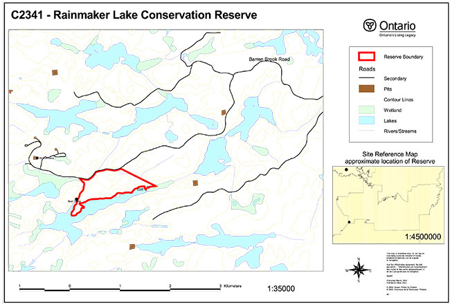
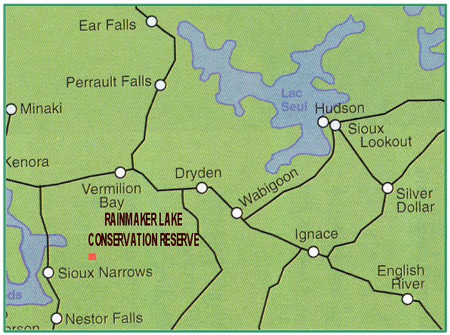
| General Location Description | Located approximately 70 km southwest of the City of Dryden, 40 km southwest of the Town of Vermillion Bay, northeast of Rainmaker Lake. |
| Access | Access can be gained via a forest access road off of Barren Brook Road (CP #61 Rd.). |
Figure 1: General location of Rainmaker Lake Conservation Reserve.
For a more detailed map of site location see Appendix A.
Enlarge Figure 1: General location of Rainmaker Lake Conservation Reserve.
Table 1.2: Representation Targets: Summary of earth science, life science, cultural resource values and present or possible recreational opportunities.
| Life Science Representation |
Upland Forest : Wetland: Animal Species: |
|---|---|
| Earth Science Representation | Underlain with granitic rock Evidence of two fault lines present Thin covering of till ground moraine |
| Cultural Value Representation | No documented cultural values |
| Recreational Opportunities | Opportunities exist for canoeing, exploring, hunting (large mammals and waterfowl), snowmobiling, fishing, bird watching and general nature activities. |
Table 1.3: Survey Information: Overview of the inventories completed, their level of detail and inventories that are needed.
| Survey Level | Life Science | Earth Science | Cultural | Recreational |
|---|---|---|---|---|
| Reconnaissance |
|
|
|
|
| Detailed |
|
|
|
|
2.0 Values to be protected
This section provides a description of the key natural heritage values on the site, their condition relative to past resource and management activities, and their sensitivity to future land use and management activities.
Table 2.1: Values Identified on Rainmaker Lake Conservation Reserve.
| Life Science |
|
|---|---|
| Earth Science |
|
| Cultural |
|
| Aboriginal |
|
| Tourism |
|
| Recreational Fishing |
|
| Recreational Hunting |
|
| Trapping |
|
| Bear Management Area |
|
| Bait Harvesting |
|
| Commercial Fishing |
|
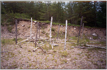
Figure 2: Old hunt camp located approximately 1 km from the reserve.
2.2 Values to be protected
The intent of this SCI is to protect the following values by establishing management guidelines for existing and potential uses in this area given the level of past disturbance and the nature of the existing features.
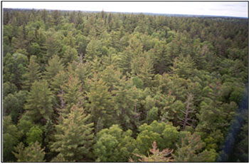
Figure 3: Aerial view of old growth red and white pine.
2.2.1 Forest values
Old growth red and white pine can be found throughout this site. None of the significant forest values found require additional protection other than that already provided by this Statement of Conservation Interest. (See Section 3.0 Management Guidelines)
2.2.2 Biological values
Several tiger beetles (Cicindela denikei) were seen along the forest access road at the boundary of the reserve. As well, the New England violet (Viola novae-angliae House) was found in the red pine mixed wood forest along a moist swale. Both are considered provincially rare species.
2.2.3 Landform values
None of the bedrock or surficial geological features determined during the Earth and Life Science Inventory were deemed significant.
2.2.4 Recreational values
The Recreation Resource Inventory regarded the forest, rolling landscape, terrestrial and aquatic wildlife, and cliffs as recreation features. Present and potential recreation activities included hunting, trapping, hiking and large tree observation. The significance of these features was rated as moderate. It was determined that none of the aforementioned features would be sensitive to recreational use. (Recreation Resource Inventory Report, 2002) Resource development, however, would result in the harvesting of significant trees (red and white pine) and loss of habitat for key species (i.e. moose, deer, bear). (Life Science Inventory, 2001)
2.2.5 Tourism values
This area is currently not being used for tourism purposes.
3.0 Management guidelines
3.1 Land tenure
The Rainmaker Lake Conservation Reserve consists entirely of Crown land within the unorganized area southeast of Dryden and Vermillion Bay. This reserve is also completely surrounded by Crown land.
The conservation reserve will remain Crown land and no dispositions (including Land Use Permits or Licenses of Occupation) will be issued for the site.
The disposition of adjacent Crown Land will be dealt with on a case-by-case basis.
Unauthorized occupations of lands within the conservation reserve will be handled in accordance with approved policy, and any required structural removal will be at the owner’s expense.
3.2 Existing and proposed development
There is an inactive forest access road leading off of Barren Brook Road (Camp #61 Rd.) that runs along the north boundary of the reserve. The Recreation Resource Inventory stated that evidence exists of ATV use to access the reserve from this road. Approximately 32% of the Conservation Reserve area has been harvested, in the north and east regions. Some of the areas in the east also contain landings and skid trails. Hardwood components make up the primary regeneration. As well, there are 5 gravel pits within 750 to 1300 m of the reserve.
Facility infrastructure and development for recreational and/or educational purposes may be considered in the future if there is a demonstrated demand for such facilities. All provincial policies that guide development on Crown Land are applicable in Conservation Reserves. A more detailed management plan would be required prior to any development occurring. The management plan would have to ensure there would be no negative impacts to any habitat or ecosystem pertinent to the values protected in this reserve. In particular, the old growth red and white pine as well as the species described by Section 2.2.2.
3.3 Recreational activities
Most recreational activities that have traditionally been enjoyed in this area can continue provided they pose no threat to the natural ecosystems and features protected by the Conservation Reserve. Those uses that are regulated include hunting, fishing and trapping. Most other permitted activities are non-regulated (i.e. canoeing, exploring, hiking). See Section 2.2.4 for the recreational uses for this Conservation Reserve as determined by the Recreation Resource Inventory.
Mechanical travel is permitted only on the existing roads and trails. Off trail mechanized travel is permitted for retrieval of game only.
3.4 Commercial activities
No new activities, such as commercial logging, hydroelectric power development, new transmission lines (e.g. power or communications), pipelines, highways or roads and the extraction of aggregate or peat, will be permitted.
An examination of the possible impact of activities on adjacent lands should be evaluated in the Forest Management Plan. Particularly in this case, due to the reserve’s small size and increased susceptibility to edge effects.
Currently there are no remote tourist camps located on or near the reserve.
3.5 Aboriginal interests
Aboriginal consultation is ongoing. To date, no issues have been voiced concerning this reserve. Nothing in this Statement of Conservation Interest affects in any way existing or future Aboriginal or treaty rights.
3.6 Natural Resources Stewardship
Natural Resource Stewardship involves the consideration of the following specific natural resource management categories.
3.6.1 Vegetation management
Management within the conservation reserve will allow for the continuation of natural ecosystem processes and functions with minimal human interference.
The forest in the entire area is to be protected from any human alteration. Forest fire protection will be carried out on the Conservation Reserve as on surrounding public lands, with a "light on the land" approach (i.e. no bulldozers, no camp construction, minimal cutting).
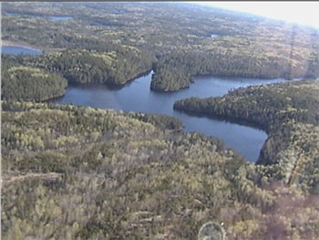
Figure 4: Aerial view of the lake on the southern border of the reserve.
Silvicultural practices and/or prescribed burns to reestablish red and white pine were recommended for future management of the site (Life Science Inventory, 2001). As well, it was suggested in the Life Science Inventory that the skid trails and landings be rehabilitated.
Forest insect and disease management will continue as on surrounding Crown lands.
3.6.2 Fish and Wildlife Management
Existing Wildlife Management Unit and sport fishing regulations and management activities will apply.
3.6.3 Landforms
None of the landforms mentioned will be altered by landform modification activities such as filling and extraction. The extraction of aggregates and similar materials are not permitted.
Careful mineral exploration may occur in specific new conservation reserves proposed through Ontario’s Living Legacy, in areas that have provincially significant mineral potential. If a portion of the new conservation reserve is to be developed for a mine, it would be removed from the reserve, and appropriate replacement lands would be placed in regulations.
3.7 Cultural Resources Stewardship
To fully manage and protect sites, field surveys are required. To date, there have been no surveys done to assess cultural or heritage values. However, common knowledge of the area suggests there to be no such values on this site, thus Cultural Inventories were deemed unnecessary.
3.8 Client services
Given the focus on low key management, client information will be given on an inquiry basis only and will deal with the basic level of information with respect to access, natural heritage appreciation, recommended activities and boundaries.
3.9 Research
Non-destructive research by qualified individuals will be encouraged to provide a better understanding of the natural values protected by the Conservation Reserve and to advance protection, planning and management.
In order to assist in enhancing the management guidelines for the reserve, the collection of additional earth and life science information during research is encouraged.
All research programs will require the approval of the Ministry of Natural Resources as will the removal of any natural or cultural specimen. The establishment of permanent plots, observation points or facilities must also be approved and be compatible with the Conservation Reserve protection objective. Any site disturbed by research activities must be rehabilitated as closely as possible to its previous state.
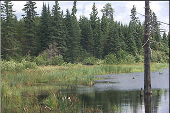
Figure 5: Moose (centre) found in a wetland area on the reserve.
3.10 Marketing
Awareness of the Conservation Reserve is promoted through the Living Legacy web site. Intensive management activity to increase use is not required at this time.
4.0 Implementation
Implementation of this Statement of Conservation Interest will primarily involve monitoring activities to ensure adherence to the management guidelines and responding to inquiries about the site.
Implementation of this statement and management of the reserve are the responsibility of the Wabigoon Forest Area Supervisor. Partnerships may be pursued to address management needs.
5.0 Review and revisions
This Conservation Reserve Statement of Conservation Interest will be reviewed on an ongoing basis.
If changes in management direction are needed at any time, the significance of the changes will be evaluated and further consultation a possibility. Any major amendments will require full public consultation and the approval of the District Manager and Regional Director. Affected clients will be immediately informed of proposed changes to this Statement of Conservation Interest.
This Statement of Conservation Interest complies with all requirements of the Environmental Assessment Act and the Environmental Bill of Rights.
5.2 Public consultation
5.2.1 Results of past consultations
Consultation on the Rainmaker Lake Conservation Reserve was conducted as part of the consultation on the Ontario’s Living Legacy Land Use Strategy, July 1999. Subsequent consultation also took place in June of 2001 to identify any stakeholder issues with the proposed Conservation Reserve.
District Manager letters were sent to the Dryden Forest Management Co., Weyerhaeuser and Ontario’s Forest Industries Association. An additional 87 stakeholder letters were sent out to tourist operators, advisory committees, trappers, land owners and members of the public on June 7, 2001. As well, newspaper ads were placed in the Ignace Driftwood, June 20 and in the Dryden Observer, June 19, 2001. One phone reply was made to Dryden District Office. Significant issues stressed concerned permitted uses. As a result of the consultation process concerns were addressed and no analysis was needed.
First Nations Consultation letters were sent to ten Native communities including Wabigoon Lake Ojibway Nation, Aboriginal People of Wabigoon and Eagle Lake First Nation. No issues have been voiced to date. Direct consultation with Treaty 3 First Nations is being carried out on a regional basis.
5.2.2 Present and future consultation
More widespread consultation is deemed unnecessary at this time.
5.2.3 Author
This Statement of Conservation Interest was prepared by Alicia H.L. Morin, OLL Intern, Information Management, Dryden District. Assistance was provided by Martin Pell of the Dryden District and Jim Cameron of the Thunder Bay Regional Office.
6.0 References
Northern Bioscience. Earth Science Inventory for Rainmaker Lake Conservation Reserve. 2001.
Northern Bioscience. Life Science Inventory for Rainmaker Lake Conservation Reserve. 2001.
Ontario’s Living Legacy Land Use Strategy. July, 1999. p. 24. Queen’s Printer for Ontario.
Ontario Ministry of Natural Resources. Rainmaker Lake Conservation Reserve (C2341) Fact Sheet. June 2001.
Ontario Ministry of Natural Resources. Rainmaker Lake Conservation Reserve (C2341) Recreation Resource Inventory Report. 2002.
Ontario Ministry of Natural Resources, Lands & Natural Heritage, Lands & Waters. Conservation Reserve Policy and Procedure PL 3.03.05. February, 1997. 22 pp.
Appendix A: Map of Rainmaker Lake Conservation Reserve