Resource Management Plan for Bob Lake, East Lady Evelyn Lake, Jim Edwards Lake, Makobe Grays Ice Margin, North Yorston, Pinetorch Lake, Smith Lake and Sugar Lake Conservation Reserves
This document provides policy direction for the protection, development and management of Bob Lake, East Lady Evelyn Lake, Jim Edwards Lake, Makobe Grays Ice Margin, North Yorston, Pinetorch Lake, Smith Lake and Sugar Lake Conservation Reserves and their resources.
Resource Management Plan
For
Conservation Reserves
- CR 44 Bob Lake
- CR 32 East Lady Evelyn Lake
- CR 52 Jim Edwards Lake
- C 1608 Makobe Grays Ice Margin
- CR 53 North Yorston
- CR 50 Pinetorch Lake
- CR 55 Smith Lake
- CR 33 Sugar Lake
Temagami Integrated Planing
June 2007
© 2007, Queen’s printer for Ontario
Single copies of this publication are obtainable from the Ministry of Natural Resources free of charge; there may be a charge for multiple copies.
Contact:
Ministry of Natural Resources
North Bay District Office
3301 Trout Lake Road
North Bay, ON
P1A 4L7
Telephone: 705-475-5550
ISBN 978-1-4249-4256-5 (Print)
ISBN 978-1-4249-4257-2 (PDF)
Approval statement
Dear Sir/Madam:
The Ministry of Natural Resources, Field Services Division, is pleased to approve the Resource Management Plan for Bob Lake, East Lady Evelyn Lake, Jim Edwards Lake, Makobe Grays Ice Margin, North Yorston, Pinetorch Lake, Smith Lake and Sugar Lake conservation reserves. This plan includes direction for the management of these eight conservation reserves and outlines the Ministry of Natural Resources' management intent for the protected areas involved. The plan provides the foundation for ongoing custodial management that includes continued monitoring of activities and other related stewardship activities within the eight conservation reserves and guidance for the management of these conservation reserves in association with two additional resource management plans that address adjacent provincial parks and Crown land recreational management.
The plan includes an implementation strategy and a summary of the public consultation that has occurred to date as part of the planning process. The plan for the eight conservation reserves will be reviewed at approximately ten-year intervals. At that time, the plan may be amended or re-written in response to changing issues or conditions.
I wish to extend my sincere thanks to all those who have participated in the planning process and encourage you to review this management plan.
Yours truly,
Signed by:
Eric Doidge
Regional Director
Northeast Region
Date: June 11, 2007
Section I: Temagami integrated planning process
1.0 Introduction
1.1. Background
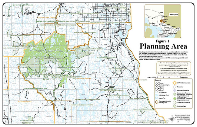
The Temagami area, located 100 km north of North Bay, covers approximately 650,000 hectares of varied and rugged terrain (Refer to Figure 1). Much of the area is forested, relatively remote, offering solitude and challenge for those seeking a backcountry recreation experience.
The Temagami area is renowned for its rugged, forested landscape as well as its significant natural, cultural and recreational resources. Temagami has been a tourist destination for over a century, and with over 2,400 kilometres of interconnecting canoe routes and portage trails it is considered one of North America’s premier canoeing destinations. Temagami encompasses numerous lakes and beaches, rivers, rapids and waterfalls, old-growth forests, rolling hills, rock outcrops, glacial features, steep cliffs and occasional canyons. These all combine to provide a rich diversity of rugged and scenic landscapes and offer opportunities for high quality backcountry travel and wilderness recreation. Popular summer activities include canoeing, camping, swimming, boating, fishing and wildlife viewing. In winter, the Temagami area is highly regarded as a destination for snowmobiling, dog sledding, snowshoeing and ice fishing. Hunting is another popular recreational activity that takes place from late summer into early winter.
The area attracts visitors from provincial, national and international markets. Recreational use is quite high, with a 1995 survey estimating over 60,000 visitor days of wilderness canoeing and other backcountry use. Use is expected to increase with growing interest in adventure travel and relatively accessible wilderness experiences. The majority of travel into the core parks and conservation reserves occurs from Crown land access points that are a considerable distance away from the protected areas. Often, recreational users travel in and out of parks, CRs and Crown land continuously, unaware of the land use designations they cross.
Five provincial parks covering 104,248 hectares lie in the western part of Temagami. Surrounding the parks are eight conservation reserves which make up an additional 42,836 hectares of protected area. The remaining land base subject to the Temagami Integrated Planning (TIP) process consists of Crown lands.
Until the early 1990s, the Ministry of Natural Resources played an active role in maintenance of Temagami’s recreational land base. This primarily included making use of the Ontario Ranger program to provide staff and resources to enable canoe route, portage and campsite maintenance to occur.
Changing government priorities led to discontinuance of the maintenance program by the provincial government in the early 1990s. The shortfall in recreational maintenance was recognized in the approved Temagami Land Use Plan in its paper The Temagami Recreation Area Strategy. Since that time, some tourism operations, youth camps and other users have undertaken some maintenance to those selected canoe routes and campsites on Crown Land of which they make the most use. In addition Ontario Parks commenced the operation and active management of the five provincial parks covered in this planning process in 2004. However, the lack of maintenance, and high concentration of use in the more accessible areas of Crown land and conservation reserve have caused campsite conditions to deteriorate.
The Background Information document prepared as part of this planning process provides a detailed description of the natural, geographical and cultural environments that make up the Temagami Area.
1.2. An Integrated planning process
Management direction for the TIP Planning Area will comply with the Temagami Land Use Plan (TLUP), Ontario’s Living Legacy (1999) where applicable, and associated protected areas legislation and policy. However, major land use decisions and management direction for the TIP area are outlined within the TLUP. This document reaffirmed Temagami’s existing provincial parks and identified four primary land use zones for the entire Temagami area as follows: Protected Areas, Special Management Areas, Integrated Management Areas, and Developed Areas. These four types of zones are subdivided into 59 specific management areas. The TLUP continues to provide the overall direction for the management and use of natural resources within each specific management area.
The Temagami Land Use Plan provides direction for the development of management plans for provincial parks and protected areas (now conservation reserves). In addition, the TLUP provides direction to develop a plan to manage the increasing recreational use of the area’s unregulated Crown lands (that is, Crown lands not regulated as a provincial park or conservation reserve). The intent of this planning process is to follow through on these commitments.
The Temagami Integrated Planning (TIP) project is not about making changes to the existing TLUP; rather, it will implement aspects of the plan. TIP will neither create new protected areas, nor reduce the size of any of the existing protected areas.
To ensure a consistent planning approach, the following three components are integrated into one overall planning process:
- Management planning for the five provincial parks (wilderness and waterway)
- Management planning for the eight conservation reserves physically connected to the parks
- Development of a Crown Land Recreation Plan for the Temagami area
All three components are strongly interrelated. The integrated planning process will explore ecological, social and recreational linkages between the interconnecting parks, conservation reserves and Crown land. The integrated process will aim to provide opportunities for ecological sustainable land use, including traditional outdoor heritage activities and associated economic benefits, and a seamless recreational experience for individuals who travel across the three different land use designations. Such opportunities will ensure that the primary objective for the TIP provincial parks and conservation reserves (i.e., to permanently protect representative ecosystems, biodiversity, and provincially significant elements of Ontario’s natural and cultural heritage and to manage these areas to ensure that ecological integrity is maintained) is achieved.
The TIP process will provide management direction and outline the management intent for each of the five parks, eight CRs and adjoining Crown land. Refer to Figure 1 for a detailed map of the planning area and the three planning components. Readers may wish to consult all three plans in order to gain an appreciation for management direction within the entire planning area.
1.2.1. Provincial parks
The mandate of Ontario Parks is to deliver the Provincial Parks and Protected Areas Program which includes the protection and management of provincially significant natural, cultural and recreational environments; provincial park operations; provision of tourism opportunities; natural heritage education in provincial parks; planning, policy development and management direction of provincial parks and protected areas; and monitoring, auditing and public reporting on Ontario’s parks and protected areas.
Provincial parks are administered under the Provincial Parks Act . Provincial parks covered by TIP fall into two of six classes of parks within the Ontario Provincial Park System—Wilderness and Waterway. Wilderness parks are substantial areas where the forces of nature are permitted to function freely and where visitors travel by non-mechanized means and experience expansive solitude, challenge and personal integration with nature. Waterway parks incorporate outstanding recreational water routes with representative natural features and historical resources to provide high quality recreational and educational experiences. The following five provincial parks are included in the TIP process:
- Lady Evelyn-Smoothwater Provincial Park (Wilderness)
- Makobe-Grays River Provincial Park (Waterway)
- Obabika River Provincial Park (Waterway)
- Solace Provincial Park (Waterway)
- Sturgeon River Provincial Park (Waterway)
1.2.2. Conservation Reserves
Conservation Reserves (CRs) are protected areas regulated under the Public Lands Act.
- Bob Lake Conservation Reserve
- East Lady Evelyn Lake Conservation Reserve
- Jim Edwards Lake Conservation Reserve
- Makobe Grays Ice Margin Conservation Reserve
- North Yorston Conservation Reserve
- Pinetorch Lake Conservation Reserve
- Smith Lake Conservation Reserve
- Sugar Lake Conservation Reserve
1.2.3. Crown lands in the Temagami area
The third component of this integrated process is the development of a recreation plan for all Crown lands covered under the Temagami Land Use Plan. Due to the complex patterns of recreational use among the parks, CRs and adjacent Crown lands, the development of the Temagami Crown Land Recreation Plan will be integrated into the protected areas planning process. This will ensure that management direction for recreation on Crown land is consistent with planning for the five provincial parks and eight CRs. The Temagami Crown land recreation plan will help to achieve a number of objectives within the TLUP. The Temagami Crown land recreation plan will examine only recreational activities that occur on Crown land in the area. Other resource management activities, which occur on the same land base, are addressed in the Temagami Land Use Plan. For example, forestry is an activity permitted or prohibited in accordance with the land use plan. Where permitted, it is planned and approved through the development of forest management plans.
1.2.4. What areas are not covered in the TIP planning process?
Scattered across the Temagami area are an additional nine conservation reserves and two provincial parks which are not included in this planning process. These protected areas are not physically connected to the core protected areas in this process. The management of these Conservation Reserves will be guided by individual Statements of Conservation Interest, legislative and associated CR policy statements. The conservation reserves referred to are: CR3a Matabitchuan River, CR4a South Temiskaming Shoreline, CR5 Ottertail Creek, CR9 Rabbit Lake West, CR15 Cliff Lake, CR17 White Bear Forest, CR31b Indian Bay South, CR40a Narrows Island and CR40b Temagami Island North. Two provincial parks, Finlayson Point and W.J.B Greenwood are not included in integrated planning and have an approved park management plan and interim management statement respectively. Two other parks are outside of the planning area; Sturgeon River Provincial Park Additions and Temagami River Provincial Park, were recommended in the 1999 Ontario’s Living Legacy Land Use Strategy. These parks are outside of the integrated planning area and will be guided by Ontario’s Living Legacy policies, legislation and current management direction via Interim Management Statements and provincial park policies.
1.2.5. Aboriginal context
For more than 6,000 years, aboriginal inhabitants have lived in the Temagami area, travelling by way of an interconnected system of winter and summer trails and portages. Temagami lies within Daki Menan, the ancestral homeland of the Teme-Augama Anishnabai—the deepwater people. Many sacred sites are found within the area, and the landscape of Temagami continues to hold great cultural, spiritual and economic significance for First Nation communities. Present-day First Nation communities include Bear Island on Lake Temagami and Matachewan on the Montreal River. A strong tradition of stewardship continues today through ceremonies, culture and language, and the spirit of the land is cared for by the original keepers of the land.
Settlement of the Temagami Land Claim is entirely separate from the Temagami Integrated Planning process, but there is some overlap between recreation management on unregulated Crown land and the Crown lands which may form part of the land claim settlement.
The Temagami Land Claim settlement process proposes the creation of a waterway class provincial park on certain portions of the mainland of Lake Temagami. Those portions of the mainland that are identified for park creation in the proposed settlement agreement can be converted to park status, following whatever requirements may be necessary, once there is final agreement. Management planning for this proposed park will be a separate process.
It is mutually understood that any communications and cooperation between the Temagami or Matachewan aboriginal communities and MNR for planning and operations purposes, as part of Temagami Integrated Planning, are undertaken without prejudice to any ongoing or future discussions or negotiations between the government of Ontario and these aboriginal communities.
Nothing in this plan shall be construed so as to abrogate or derogate from the protection provided for the existing Aboriginal or treaty rights of the Aboriginal people of Canada as recognized and affirmed in section 35 of the Constitution Act, 1982.
1.2.6. Integration with other related plans
The Conservation Reserve Resource Management Plan specifically addresses the long-term protection and management for the TIP CRs.
Whenever possible, implementation of this plan will occur in a manner which fully considers and complements the management direction included in the plans for the five provincial parks and Crown land recreation, which were developed in conjunction with this plan.
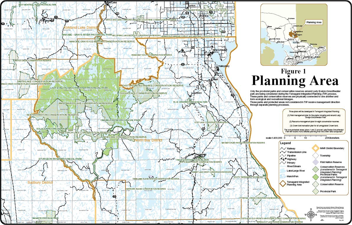
Figure 1: Planning area
Enlarge figure 1 planning area map
Section II: Conservation Reserve Resource Management Plan
1.0 Goal and objectives of the Resource Management Plan
1.1. Goal
The goal of this Resource Management Plan is to provide the policy and resource management framework to guide management decisions affecting the eight conservation reserves covered in this planning document.
1.2. Objectives
The following objectives are identified as the means to achieve the above-stated goal:
- To describe the current state of the resource in terms of the eight conservation reserves' values and existing uses and activities
- To outline the Ministry of Natural Resources' management intent for these conservation reserves
- To determine the land use compatibility of current land uses, and to develop specific guidelines and prescriptions to manage these uses
- To create public awareness of the values within these conservation reserves by providing information on the resources they contain and protect, and to support responsible stewardship through partnerships with local stakeholders
- To provide for the establishment of a maintenance program that will contribute to sound long-term management of recreational use within the conservation reserves where deemed appropriate
- To identify the monitoring and/or research necessary to maintain the integrity of protected values within the eight conservation reserves
1.3. Specific management objectives for all CRs within the tip process
General management objectives for all CRs
| Access | Allow for a variety of access opportunities while controlling access so as to ensure the continued remote character of the conservation reserves. |
|---|---|
| Angling & Hunting | In cooperation with MNR Fisheries and Wildlife Branch, protect enhance and monitor aquatic and terrestrial ecosystems that support sustainable angling and hunting via partnerships and possibly implementation planning. |
| Boat Caches | Establish minimum standards for boat caching, and where required, a boat cache management system in conjunction with the Crown land base of the TLUP. The latter could include a free permit sticker and a limit on the number of boats cached within designated zones of conservation reserves where boat caching is problematic. |
| Campsites | Maintain campsites to the same standards as in the adjacent wilderness and waterway provincial parks. |
| Canoe Routes | Maintain canoe routes to the same standards as in the adjacent wilderness and waterway provincial parks. |
| Cultural Heritage | Provide for the identification, conservation, interpretation and wise-use of the area’s cultural heritage resources. |
| Ecological Integrity | Manage CRs on the principle of maintaining their ecological integrity. Ecological integrity consists of maintaining the natural components of an ecosystem including the abiotic components (the physical elements, e.g., water, rocks), biodiversity (the composition and abundance of species and communities in an ecosystem, and ecosystem processes (the engines that make ecosystems work; e.g., fire, flooding, predation). |
| Education | Develop a public education program geared towards sustainable recreational use of conservation reserves, proper backcountry ethics and protection of sensitive features and values. |
| First Nations | Protect existing Aboriginal and treaty rights that are recognized and affirmed under the Constitution of Act (1992). The Crown has a duty to consult with local First Nation and Aboriginal communities who have existing aboriginal or treaty rights which may be infringed upon. Any First Nation land claims within this area will be addressed according to the appropriate Ontario Government procedures. The Ontario Government has stated that designation of areas as conservation reserves is not irreversible and would not preclude consideration of lands, if appropriate, in future claims negotiations or settlement. |
| Protection | To permanently protect representative ecosystems, biodiversity and provincially significant elements of Ontario’s natural and cultural heritage and to manage these areas to ensure that ecological integrity is maintained. |
| Research & Monitoring | Facilitate scientific research and monitoring to provide points of reference to support monitoring of ecological change on the broader landscape |
| Traditional Outdoor Heritage Activities and Associated Economic Benefits | Provide opportunities for ecologically sustainable land uses including traditional outdoor heritage activities and associated economic benefits. |
2.0 Planning and direction
2.1. Planning area
The planning area for this resource management plan is the regulated boundary of the following eight conservation reserves (refer to maps in section 3.0 for the regulated boundary of each individual CR):
- Bob Lake Conservation Reserve
- East Lady Evelyn Lake Conservation Reserve
- Jim Edwards Lake Conservation Reserve
- Makobe Grays Ice Margin Conservation Reserve
- North Yorston Conservation Reserve
- Pinetorch Lake Conservation Reserve
- Smith Lake Conservation Reserve
- Sugar Lake Conservation Reserve
2.2. Planning direction
Conservation Reserves (CRs) are protected areas regulated under the Public Lands Act. CRs protect natural heritage features and values by prohibiting industrial activities such as commercial timber harvest, mining activity and exploration, hydro development, aggregate extraction and removal of peat or topsoil. Many traditional, non-industrial and compatible activities are permitted to continue.
Planning direction is documented via the Resource Management Plan (RMP). A RMP provides a policy and resource management framework and is prepared in situations where one or more complex issues have to be addressed, or where there is widespread public interest. RMPs are reviewed every ten years. Permitted uses in the above-stated conservation reserves are outlined in the Temagami Land Use Plan, with the exception of Makobe Grays Ice Margin Conservation Reserve where direction comes from Ontario’s Living Legacy Land Use Strategy and Conservation Reserves Policy. Where these sources are silent, direction for all eight conservation reserves is derived from Conservation Reserves Policy or an alternate approved policy where applicable. Permitted use tables can be viewed in Chapter 4.0.
Upon proclamation of Ontario’s new Provincial Parks and Conservation Reserves Act (2006), creation and management of CRs will no longer fall under the Public Lands Act, but instead will occur under the new Provincial Parks and Conservation Reserves Act. In accordance with this new Act, it must be recognized that maintaining the ecological integrity for which specific conservation reserves were created is the first priority when planning and managing CRs. Once the new Act is proclaimed, MNR will review any decisions made regarding management of the CRs to ensure consistency with provisions of the new Act.
Planning and management of conservation reserves under the new Act also includes an objective to permanently protect representative ecosystems, biodiversity, provincially significant heritage values, and provide opportunities for ecologically sustainable land uses, including traditional outdoor heritage activities and associated economic benefits.
Proposed undertakings and/or new developments for all conservation reserves will be reviewed on a case-by-case basis and subject to the Class Environmental Assessment (Class EA) for Provincial Parks and Conservation Reserves. The Class EA for Provincial Parks and Conservation Reserves (OMNR, 2003) will be used to screen all proposals and management activities occurring within conservation reserves.
2.3. Management
Management of conservation reserves is the responsibility of the Ministry of Natural Resources at the district level, and will be done in accordance with the Public Lands Act (to be replaced by the PPCR Act), Temagami Land Use Plan, Conservation Reserve Policy and this resource management plan. All Conservation Reserve planning documents are approved by the MNR Regional Director.
This Resource Management Plan will govern the lands and waters within the regulated boundaries of the above-stated conservation reserves for a twenty year period commencing with the date of approval of this management plan (2007-2027). Review of the management direction outlined in this document shall occur ten years following its approval at which time any necessary amendments will be made at the discretion of the District Manager or Conservation Reserve Manager. Where future reviews and major revisions are necessary, public and Aboriginal consultation and notification on the Environmental Bill of Rights Registry will occur.
Public comment may be solicited during a review of any future land use proposals that require new decisions to be made. Appropriate Environmental Assessment Act requirements and amendment processes will apply to any future proposal and/or any significant change in management direction being considered for a CR or suite of CRs.
Where cultural resources may be impacted, proposals may be screened through A Technical Guideline for Cultural Heritage Resources for Projects Planned Under the Class Environmental Assessment for MNR Resource Stewardship and Facility Development Projects (2006) and the Class EA for Provincial Parks and Conservation Reserves (2005).
3.0 Individual Conservation Reserve information
The TLUP describes conservation reserves as including representative "old growth" red and white pine sites, watersheds containing the headwaters of rivers flowing through the wilderness park, significant wetlands, provincially significant ecological and geological features and significant recreation areas. Additional life and earth science and recreational data have been compiled via the Ontario Parks check sheet inventories for each conservation reserve within the province (for individual reports see surveys noted for each site).
The reason for the creation of conservation reserves (protected areas) under the TLUP was to complement the existing provincial parks, add to the ecological integrity of the adjacent parks, and to recognize areas with intrinsic, natural heritage and remote recreation values.
The following are site specific CR summaries that provide additional current state-of-the-resource information concerning values, existing uses, activities and issues/concerns:
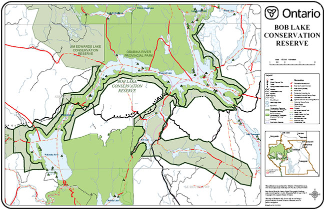
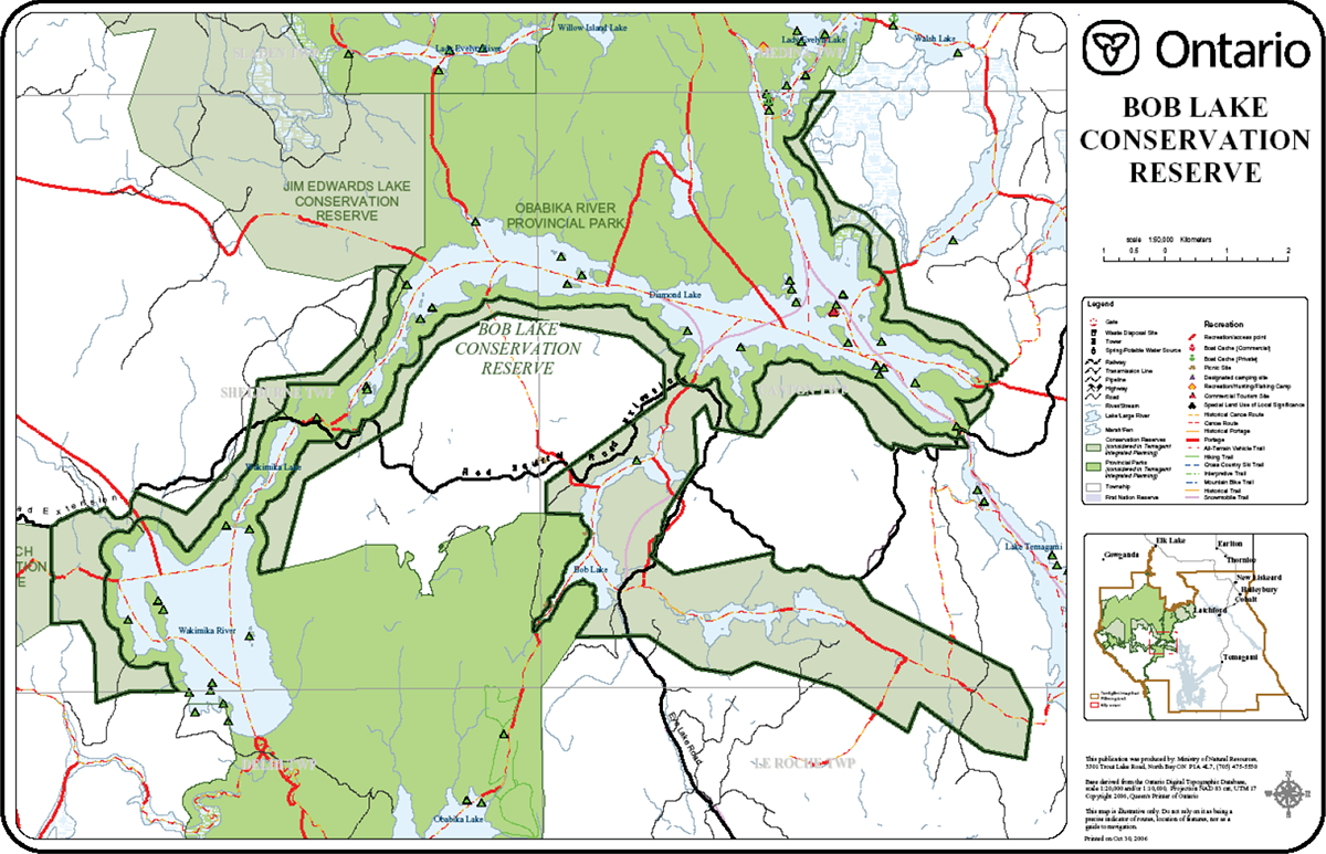
3.1. CR44 Bob Lake
| Name CR | 44 Bob Lake |
|---|---|
| Map Name | Obabika Lake |
| Map Number | 41P/1 |
| UTM Ref. | 560 250 |
| Locality | Diamond Lake |
| Latitude | 47°10' N |
| Longitude | 80°16' W |
| NAD | 83 CNT |
| Minimum Altitude | 274 m |
| Maximum Altitude | 366 m |
| Township/s | Shelburne, Delhi, Canton, Leroche |
| Area | 2,657 ha |
| Regulation | April 6, 2001 |
| Ownership | Crown |
| MNR Area | Northeast Region/North Bay District /Temagami Area |
| First Nations | Matachewan First Nation Temagami First Nation |
| Trap Lines | I-16, I-17(trap cabin), I-18, I-21, I-31, |
| BMAs | TE-40-069 and TE-40-048 |
| LUPs | None |
| Surveys Completed | Earth Science – (Kor 2002) Recreation – (Hewitson 2001) Life Science – (Morris 2000) (Cudmore and Shultz 2005) |
| Location | Bob Lake CR is located approximately 30 km southwest of Latchford, Ontario. |
| Boundary | The CR, which has a combination of ecological, cultural and vectored boundaries, forms a thin protective buffer around the Obabika River Provincial Park along Diamond Lake and Wakimika Lake and River. Boundaries surrounding Bob Lake are vectored to encompass the travel corridor. |
| Access | Access to the site is by canoe or float plane and also by un-groomed snowmobile trails in the winter. Two established road crossings of the CR are permitted to continue for exclusive use by the forest industry with timing restrictions in place; the Red Squirrel Road and Eye Lake Road |
| Special Features and Values |
|
| Specific Management Objectives |
|
| Issues and Concerns |
|
Figure 2: Bob Lake Conservation Reserve
Enlarge figure 2 Bob Lake Conservation Reserve map
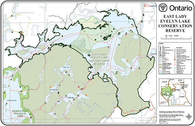
3.2. CR32 East Lady Evelyn Lake
| Name | CR32 East Lady Evelyn Lake |
|---|---|
| Map Name | Lady Evelyn Lake |
| Map Number | 41 P/8 |
| UTM Ref. | 730 440 |
| Locality | Diamond Lake |
| Latitude | 47° 23' |
| Longitude | 80° 06' |
| NAD | 27 |
| Minimum Altitude | ~290 m |
| Maximum Altitude | ~343 m |
| Township/s | Leo, Dane, Klock, Kittson |
| Area | 5,612 ha |
| Regulation | April 6, 2001 |
| Ownership | Crown, some private land surrounded by CR |
| MNR Area | Northeast Region/North Bay District /Temagami Area |
| First Nations | Matachewan First Nation Temagami First Nation |
| Trap Lines | I-06, TE-05, TE-06 |
| BMAs | TE-40-042 |
| LUPs | LTI-1058 - Rec. Camp – Expires/up for renewal April 2007 |
| Surveys Completed | Life Science – (Morris 2000) (Cudmore and Shultz 2005) Earth Science – (Kor 2002) Recreation – (Roberts 2001) |
| Location | East Lake Evelyn Lake Conservation Reserve is located approximately 17 km west of Latchford, Ontario. |
| Boundary | Ecological and cultural boundaries dominate the site. The ecological boundaries are defined by the northern shorelines of East Lady Evelyn Lake. The cultural boundaries are defined by Sugar Lake Conservation Reserve (CR33) located along the southern shorelines of East Lady Evelyn Lake. The southeastern and eastern boundaries are defined by a mix of ecological and vectored boundaries |
| Access | Access to the site is limited as there are no formal motorized trails or roadways within the site. Motorboat access is available from Mowatt’s Landing although a trailer lift over the Mattawapika Dam is required. The site is also easily accessed by canoe and can be accessed by float plane and un-groomed snowmobile trails. |
| Special Features and Values |
|
| Specific Management Objectives |
|
| Issues and Concerns |
|
Figure 3: East Lady Evelyn Lake Conservation Reserve
Enlarge figure 3 East Lady Evelyn Lake Conservation Reserve map
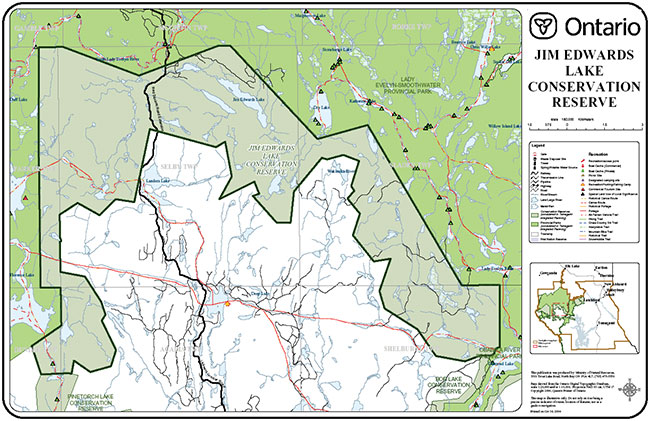
3.3. CR52 Jim Edwards Lake
| Name | CR52Jim Edwards Lake |
|---|---|
| Map Name | Lady Evelyn Lake |
| Map Number | 41 P/7, 47 P/8, 47 P/1, 47 P/2 |
| UTM Ref. | 430387 |
| Locality | Diamond Lake - Florence Lake |
| Latitude | 47° 18'N |
| Longitude | 80° 06' |
| NAD | 79° 25'W |
| Minimum Altitude | ~335 m |
| Maximum Altitude | ~564 m |
| Township/s | Parker, Selby, Sladen, Dundee, Acadian, Shelburne |
| Area | 8 656 ha |
| Regulation | April 6, 2001 |
| Ownership | Crown, |
| MNR Area | Northeast Region/North Bay District /Temagami Area |
| First Nations | Matachewan First Nation Temagami First Nation |
| Trap Lines | I-08, I-09, I-10, I-14, I-15, I-16, I-17 |
| BMAs | TE-40-043 |
| LUPs | None |
| Surveys Completed | Life Science – (Morris 2000) (Cudmore and Shultz 2005) Earth Science – (Kor 2002) Recreation – (Hewitson 2001) |
| Location | Jim Edwards Lake CR is located approximately 34 km west of Temagami, Ontario. |
| Boundary | Vectored boundaries dominate the CRs southern boundaries. The western, northern and eastern boundary connects to the Lady Evelyn Smoothwater Park boundaries; the southern tip on the west side connects to Pinetorch Lake CR and the southern tip of the east side connects to Bob Lake CR. |
| Access | Access to the site is limited, but can be obtained by canoe from Lady Evelyn Smoothwater Provincial Park (LESPP) and by floatplane. Additional access to the CR occurs via snowmobile trail originating south and east of the CR on the Red Squirrel Road. Snowmobile access is generally permitted between November 15 and April 15 each year. |
| Special Features and Values |
|
| Specific Management Objectives |
|
| Issues and Concerns |
|
Figure 4: Jim Edwards Lake Conservation Reserve
Enlarge figure 4 Jim Edwards Lake Conservation Reserve map
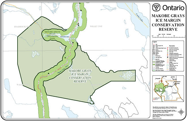
3.4. C1608 Makobe Grays Ice Margin
| Name | C1608 Makobe Grays Ice Margin |
|---|---|
| Map Name | Elk Lake |
| Map Number | 41 P/9 |
| UTM Ref. | 546527 |
| Locality | Timiskaming |
| Latitude | 47°34' N |
| Longitude | 80°23'W |
| NAD | 83 CNT |
| Minimum Altitude | 320 m |
| Maximum Altitude | 460 m |
| Township/s | Willet, Banks, Wallis, Roadhouse |
| Area | 903 ha |
| Regulation | April 6, 2001 |
| Ownership | Crown |
| MNR Area | Northeast Region/Kirkland Lake District/Elk Lake-Matheson Area |
| First Nations | Matachewan First Nation Temagami First Nation |
| Trap Lines | KL106, KL103 |
| BMAs | KL-40-015 |
| LUPs | None |
| Surveys Completed | Life Science – (Noordhof et al 2003) Earth Science – (Kor 2002) Recreation – (Hewitson 2001) |
| Location | The Makobe–Grays Ice Margin Conservation Reserve is situated approximately 28 km south of the town of Elk Lake, Ontario. |
| Boundary | The Makobe Grays Ice Margin Conservation Reserve is divided into two sections, but linked by Makobe-Grays Provincial Park. Both sections are contained by a combination of biological and vectored boundaries. For both sections, biological boundaries exist along Makobe River, along creek systems in the northern part of the site and the water’s edge of an unnamed lake in the southeastern corner of the reserve. |
| Access | Access to the CR is available by canoe route from Lady Evelyn-Smoothwater Provincial Park and arrangements can be made through Elk Lake to enter this site via floatplane. A network of forestry roads exists adjacent to the sites boundaries and may provide access. |
| Special Features and Values |
|
| Specific Management Objectives |
|
| Issues and Concerns |
|
Figure 5: Makobe Grays Ice Margin Conservation Reserve
Enlarge figure 5 Makobe Grays Ice Margin Conservation Reserve map
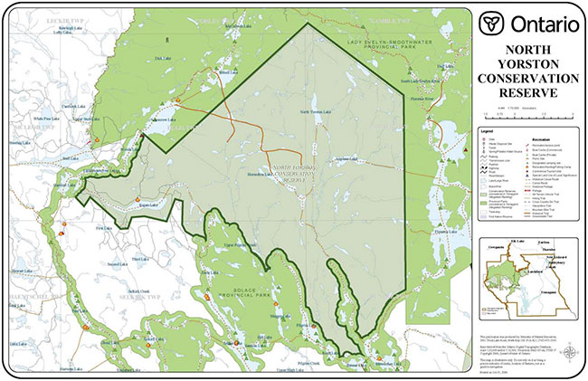
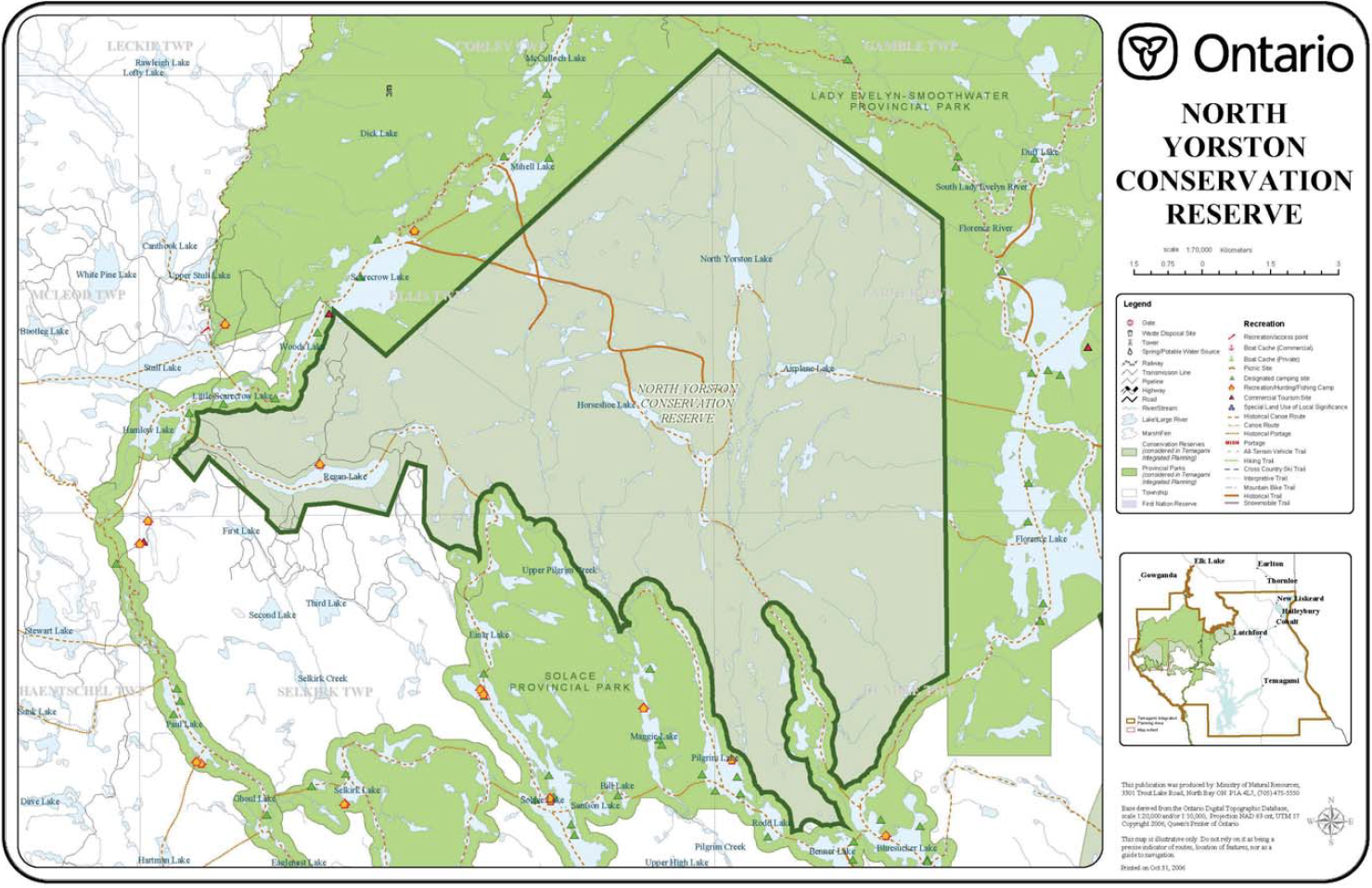
3.5. CR53 North Yorston
| Name | CR53 North Yorston |
|---|---|
| Map Name | Smoothwater Lake Pilgrim Creek |
| Map Number | 41 P/7, 41 P/2 |
| UTM Ref. | 265369 |
| Locality | Florence Lake |
| Latitude | 47° 16'N |
| Longitude | 80° 39'W |
| NAD | 83 CNT |
| Minimum Altitude | 396 m |
| Maximum Altitude | 547 m |
| Township/s | Corley, Gamble, Ellis, Parker, Selkirk, Dundee |
| Area | 13,323 ha |
| Regulation | April 6, 2001 |
| Ownership | Crown |
| MNR Area | Northeast Region/North Bay District /Temagami Area |
| First Nations | Matachewan First Nation Temagami First Nation |
| Trap Lines | SU-02, SU-04, I-07, I-08, I-13, TE-31 |
| BMAs | SU-40-037, SU-40-036 |
| LUPs | LTE-383/Rec camp on Regan Lake/Expires - up for renewal Sept. '08 |
| Surveys Completed | Life Science – (Morris 2000) (Cudmore and Shultz 2005) Earth Science – (Kor 2003) Recreation –(Smith 2001) |
| Location | North Yorston Conservation Reserve is located approximately 45 km west of Latchford, Ontario. |
| Boundary | The majority of the site’s boundaries border Lady Evelyn-Smoothwater, Solace, or Sturgeon River Provincial Parks. A portion of the southwestern boundary is vectored below Regan Lake. |
| Access | Access to the site is from the west branch of Portelance Road that leads into Sturgeon River Provincial Park. ATV and snowmobile access is permitted for LUP holder only from trail between Portelance Road and north shore of Regan lake. Besides this formal access, the only way into the CR is by water (canoe) or fly-in. |
| Special Features and Values |
|
| Specific Management Objectives |
|
| Issues and Concerns |
|
Figure 6: North Yorston Conservation Reserve
Enlarge figure 6 North Yorston Conservation Reserve map
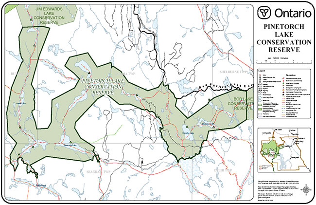
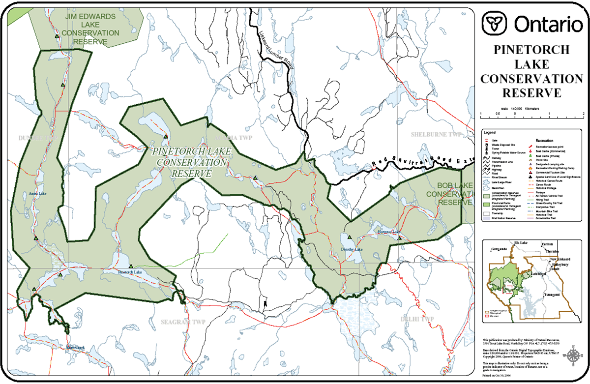
3.6. Pinetorch Lake
| Name | CR50 Pinetorch Lake |
|---|---|
| Map Name | Pilgrim Creek Obabika Lake |
| Map Number | 41 P/2, 41 P/1 |
| UTM Ref. | 373 218 |
| Locality | Florence Lake – Wakimika Lake |
| Latitude | 47°09' N |
| Longitude | 80°16'W |
| NAD | 27 CNT |
| Minimum Altitude | 305 m |
| Maximum Altitude | 518 m |
| Township/s | Dundee, Acadia, Seagram, Shelburne, Delhi |
| Area | 3,623 ha |
| Regulation | June 25, 2004 |
| Ownership | Crown |
| MNR Area | Northeast Region/North Bay District /Temagami Area |
| First Nations | Matachewan First Nation Temagami First Nation |
| Trap Lines | 1-14, I-15, I-16, I-20, I-31 |
| BMAs | TE-40-043, SU-40-037 |
| LUPs | None |
| Surveys Completed | Life Science – (Morris 2000) (Cudmore and Shultz 2005) Earth Science – (Kor 2002) Recreation – (Hewitson 2001) |
| Location | Pinetorch Lake Conservation Reserve is located approximately 38 km west of the town of Temagami. |
| Boundary | The CR connects Bob Lake CR at its eastern boundary to Jim Edwards Lake CR at its western boundary. The site’s northern and southern boundaries follow a chain of lakes and rivers and are vectored. |
| Access | Access to the site includes the Red Squirrel Rd Extension which is gated to the public, but allows snowmobiling in the winter on un-groomed trails. Access can also be obtained by canoe and float plane. |
| Special Features and Values |
|
| Specific Management Objectives |
|
| Issues and Concerns |
|
Figure 7: Pinetorch Lake Conservation Reserve
Enlarge figure 7 Pinetorch Lake Conservation Reserve map
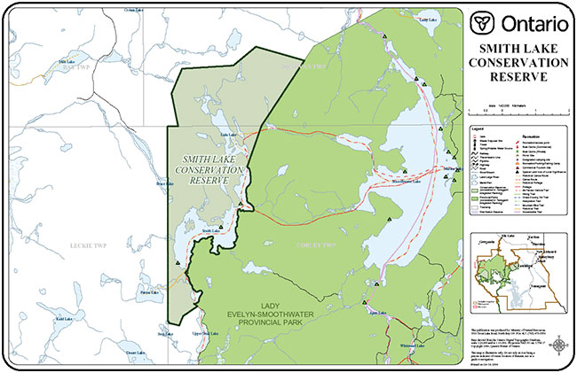
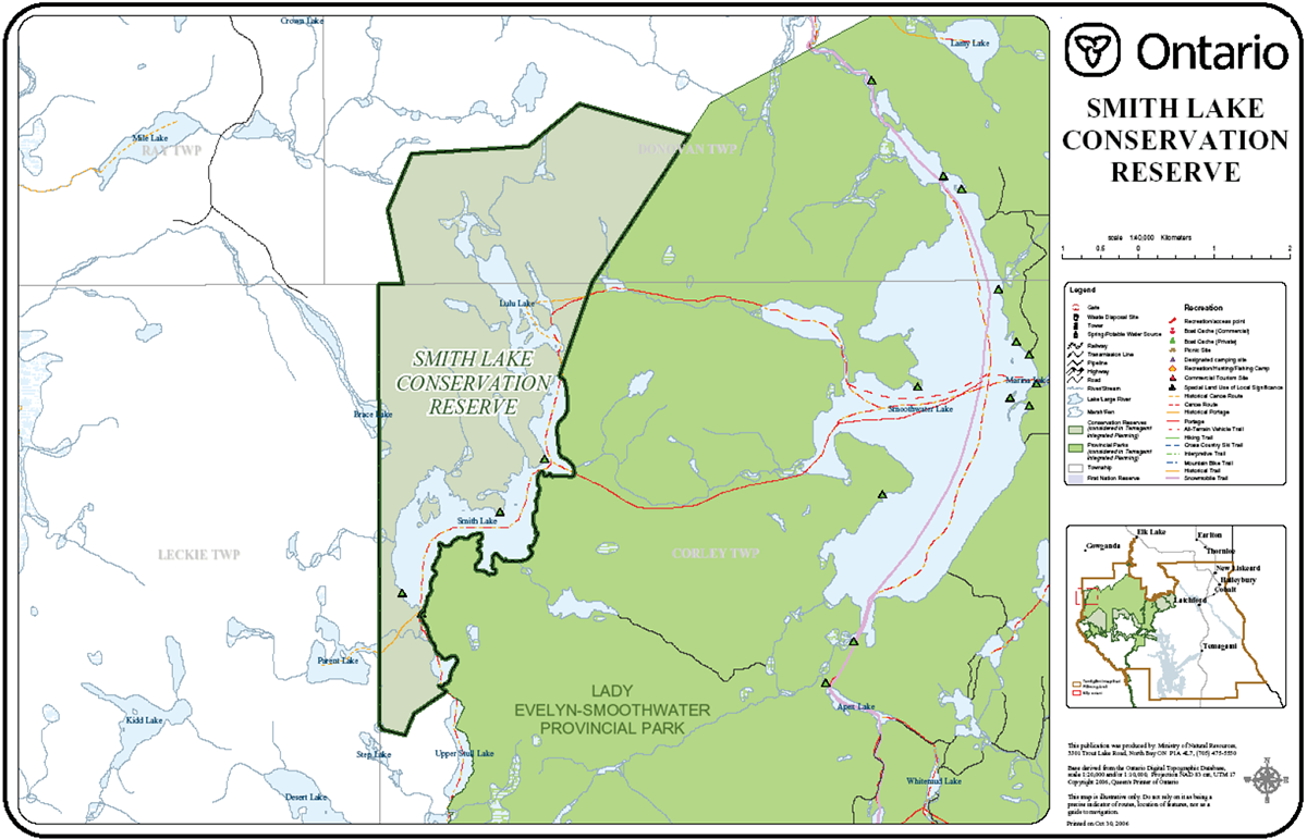
3.7. CR55 Smith Lake
| Name | CR55 Smith Lake |
|---|---|
| Map Name | Smoothwater Lake |
| Map Number | Number 41 P/7 |
| UTM Ref. | 180475 |
| Locality | Smoothwater Lake |
| Latitude | 47°23' |
| Longitude | 80°46' |
| NAD | 83 |
| Minimum Altitude | ~445 m |
| Maximum Altitude | ~615 m |
| Township/s | Donovan, Corley |
| Area | 1,649 ha |
| Regulation | April 6, 2001 |
| Ownership | Crown |
| MNR Area | Northeast Region/Kirkland Lake District/Elk Lake-Matheson Area |
| First Nations | Matachewan First Nation Temagami First Nation |
| Trap Lines | KL-100, KL-103 |
| BMAs | KL-40-017 |
| LUPs | None |
| Surveys Completed | Life Science – (Morris 2001) Earth Science – (Kor 2003) Recreation – (Smith 2001) |
| Location | The Smith Lake CR is located approximately 50 km southwest of the town of Elk Lake adjacent to the northwest corner of Lady Evelyn Smoothwater Provincial Park (LESPP). |
| Boundary | The eastern boundary borders LESPP, the southwestern boundary follows the township line and the northern and northwestern boundaries are vectored. |
| Access | Access to the site is by ATV and snowmobile from the forestry road network to the northwest and by canoe and float plane |
| Special Features and Values |
|
| Specific Management Objectives |
|
| Issues and Concerns |
|
Figure 8: Smith Lake Conservation Reserve
Enlarge figure 8 Smith Lake Conservation Reserve map
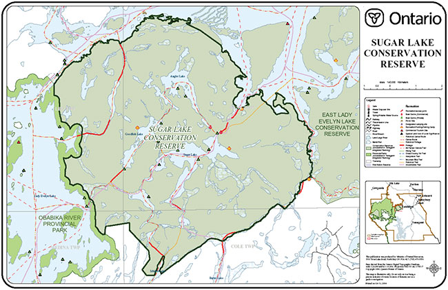
3.8. CR33 Sugar Lake
| Name | CR33 Sugar Lake |
|---|---|
| Map Name | Lady Evelyn Lake |
| Map Number | 41 P/8 |
| UTM Ref. | 670 455 |
| Locality | Lady Evelyn Lake |
| Latitude | 47° 20'N |
| Longitude | 80° 07'W |
| NAD | 83 |
| Minimum Altitude | 290 m |
| Maximum Altitude | 389 m |
| Township/s | Medina, Dane, Leo and Cole |
| Area | 6,143 ha |
| Regulation | April 6, 2001 |
| Ownership | Crown |
| MNR Area | Northeast Region/North Bay District /Temagami Area |
| First Nations | Matachewan First Nation Temagami First Nation |
| Trap Lines | I-06, I-11, I-12, TE-05 |
| BMAs | None |
| LUPs | TEM-10150/Rec camp/Expires and up for renewal Nov. '09 TEM-10108/Rec camp/Expires and up for renewal June '13 LTI – 1060/Rec camp/Expires and up for renewal July '11 |
| Surveys Completed | Life Science – (Morris 2000) (Cudmore and Shultz 2005) Earth Science – (Kor 2002) Recreation – (Roberts 2001) |
| Location | The Sugar Lake Conservation Reserve is located approximately 17 km west of Latchford, Ontario. |
| Boundary | Cultural boundaries dominate the site as the CR is connected to two protected areas including Obabika River PP on the west and the northern and northeastern boundary lie adjacent to the East Lady Evelyn Lake CR. |
| Access | Access to the site is by canoe, un-groomed snowmobile trails and float plane. |
| Special Features and Values |
|
| Specific Management Objectives |
|
| Issues and Concerns |
|
Figure 9: Sugar Lake Conservation Reserve
Enlarge figure 9 Sugar Lake Conservation Reserve map
4.0 Management direction
4.1. Permitted uses general
The management direction outlined in this section is specific to the eight conservation reserves identified in this RMP and is intended to protect natural heritage and recreational values and features. The guidelines in this document are subject to change and may be amended as necessary. If a conflict between management guidelines exists, the conservation reserve will be managed to protect the integrity of its natural values, while permitting compatible land use activities. If a permitted use is determined to be negatively impacting any of the special features and values identified in this plan, or the ecological integrity of any one, or group of conservation reserves, then the current management direction will be reviewed, and the concern/activity will be mitigated. If mitigation is not possible the use/activity will not be permitted to continue, management direction will be changed to reflect the results of review and a Crown land use amendment will be necessary.
Proposed undertakings and/or new developments for all conservation reserves will be reviewed on a case-by-case basis and subject to the Class Environmental Assessment (Class EA) for Provincial Parks and Conservation Reserves. If new undertakings are determined through the EA process to be compatible with the values and objectives of a conservation reserve, then this management plan will be amended to reflect a new permitted activity.
Industrial
| Activity | Direction | Source of direction |
|---|---|---|
| Commercial Timber Harvest |
|
Temagami Land Use Plan |
| Mining/Mineral Exploration |
|
Temagami Land Use Plan |
| Aggregate Extraction |
|
Temagami Land Use Plan |
| Hydro Generation |
|
Conservation Reserve Policy (PL 3.03.05) |
| Extraction of peat, soil and other materials |
|
Conservation Reserve Policy (PL 3.03.05) |
| Forest Renewal |
|
Temagami Land Use Plan |
| Wind Power Development |
|
Policy and Procedure 4.10.04 "Wind Power Development on Crown Land". January 2004. |
| Communications, energy transmissions and transportation corridors |
|
Conservation Reserve Policy (PL 3.03.05) |
| Resource Access Roads |
|
|
Commercial
| Activity | Direction | Source of direction |
|---|---|---|
| Trapping |
|
|
| Trap Cabins |
|
Conservation Reserve Policy (PL 3.03.05) |
| Commercial bait fish harvesting |
|
|
| New Main Base Tourism Development (lodges, resorts) |
|
Temagami Land Use Plan |
| Outfitting – Bear Management |
|
Conservation Reserve Policy (PL 3.03.05) |
| Wild Rice Harvesting |
|
Conservation Reserve Policy (PL 3.03.05) |
| Commercial Food Harvesting |
|
Conservation Reserve Policy (PL 3.03.05) |
Recreational
| Activity | Direction | Source of direction |
|---|---|---|
| Fishing |
|
Temagami Land Use Plan |
| Hunting |
|
Temagami Land Use Plan |
| Camping |
|
Temagami Land Use Plan |
| Canoeing and Kayaking |
|
Temagami Land Use Plan |
| Aircraft Landing |
|
Temagami Land Use Plan |
| Horseback Riding |
|
Conservation Reserve Policy (PL 3.03.05) |
| Mountain Biking |
|
Conservation Reserve Policy (PL 3.03.05) |
| Rock Climbing/Caving |
|
Conservation Reserve Policy (PL 3.03.05) |
| Recreation Camps |
|
Conservation Reserve Policy (PL 3.03.05) |
| Food Gathering |
|
Conservation Reserve Policy (PL 3.03.05) |
| New motorized trail development |
|
Temagami Land Use Plan |
| New non-motorized trail development |
|
Conservation Reserve Policy (PL 3.03.05) |
Public Motorized Access
|
|
|
| Motorboat Use |
|
|
| Managed Boat Caches |
|
Temagami Land Use Plan |
Snowmobile Use
|
|
Temagami Land Use Plan |
| Low-intensity tourism or recreation infrastructure development | Not Permitted: |
|
Land and resource management
| Activity | Direction | Source of direction |
|---|---|---|
| Forest Fire Suppression |
|
|
| Prescribed Burn |
|
|
| Insect and Disease Control |
|
Conservation Reserve Policy (PL 3.03.05) |
| Wildlife Management |
|
Temagami Land Use Plan |
| Fisheries Management |
|
The Ontario fishing regulations will continue to govern fishing in the conservation reserves. |
| New Cottaging |
|
Temagami Land Use Plan |
| Land Disposition |
|
Conservation Reserve Policy (PL 3.03.05) |
| Inventory Monitoring |
|
Conservation Reserve Policy (PL 3.03.05) |
| Natural Species Management |
|
Conservation Reserve Procedure (PL 3.03.05) |
| Research |
|
Conservation Reserve Policy (PL 3.03.05) |
4.2. Special areas management
4.2.1. Lady Evelyn Lake Dunes
The esker-kame system and the dune complexes in Lady Evelyn Lake were identified as provincially significant earth science features by Noble (1998) and reaffirmed by Kor (2002). A portion of the submerged dune complex has been captured within C32 East Lady Evelyn Lake Conservation Reserve. The dunes, and to some extent, the steeper slopes of the ice-contact complex, are susceptible to erosion should the forest cover be disturbed or removed. The dunes in the heightened waters of the flooded lake are currently eroding, and are at risk to long-term changes through natural processes. The fluctuating water levels in Lady Evelyn Lake are associated with water control at the Mattawapika Dam. All operating levels for Lady Evelyn Lake will be determined and approved in the Montreal River Water Management Plan.
Recreational use is also negatively affecting the dunes through vegetation loss and increased erosion. In order to mitigate the effects of recreational use on this feature, all overnight camping within the dune complex has been prohibited. All established campsites will continue to have signage in place indicating the closure of the campsite. Ongoing monitoring of the condition of this feature will be undertaken and educational material will be provided to recreationists promoting responsible day use of the dunes.
5.0 Implementation strategy
5.1. Required actions
The Implementation Strategy for this resource management plan will meet the management objectives outlined for all eight conservation reserves. While many management objectives can be satisfied through protection and management direction (permitted uses), some objectives require further action in order to be fulfilled. The following table outlines the actions required in order to meet a specific management objective:
| Management objective | Required action |
|---|---|
| Establish Boat Cache Management System | A boat cache management system can be applied to problem areas. This system will be administered by a maintenance program and will include the development of standards for boat caches outside of problem areas. |
| Management objective | Required action |
| Develop a public education program for recreationists | A public education program will be developed and administered by MNR with the assistance and advice of Ontario Parks and a maintenance partnership. The public education program for the CRs will be developed and administered in conjunction with the Parks and Crown land covered in the TIP process. |
| Maintain Campsites and Canoe Routes | Establish a maintenance program for campsites and canoe routes within identified conservation reserves as discussed below. The maintenance program will be developed and delivered by MNR, in conjunction with Ontario Parks and a maintenance partnership with interested and supportive stakeholders. Campsites and canoe routes will be maintained to the same standards of the adjacent provincial parks as is outlined in the Standard Operating Guidelines for Ontario Parks. Sufficient time is necessary for the program to be fully implemented. |
| Lady Evelyn Lake, Jim Edwards Lake and Lulu Lake fisheries | Jim Edwards and Lulu Lakes are cold water fisheries that are recovering naturally from human-caused acid damage. Lady Evelyn Lake is a heavily used and economically important walleye fishery. All three of these lakes will be managed according to the current Ontario Fishing Regulations. Fisheries monitoring be completed for a suite of lakes at the fisheries management zone level. Lakes to be included have not yet been determined. |
| Protect existing Aboriginal and treaty rights | First Nations were represented on the planning team throughout the planning process. First Nations communities will remain active in the implementation of this resource management plan. Participation can include membership in a maintenance partnership, future implementation plans and stewardship projects that may occur in the future. |
5.2. Maintenance of recreational facilities
Initiating maintenance of identified (discussed below) conservation reserves in conjunction with the Crown land base, with specific attention to camp sites, canoe routes and portages and hiking trails is critical to continued sustainable use of the area, supporting its economic and social development in a manner which protects its environment. Maintaining recreational facilities within CRs to the same standard as is provided by Ontario Parks within its wilderness and waterway parks is a desirable level which will support a high level of recreational use, integration across the entire planning area, and satisfy the majority of recreationists. In addition, providing users with information and opportunities to learn about wilderness camping and user 'ethics' is extremely important to the promotion of appropriate and sustainable use of the area.
Recognizing the immediate need to address the lack of maintenance issue, the Ministry of Natural Resources will initiate a recreation maintenance and public information program. Funding requirements for the maintenance and public education program will be identified on an annual basis.
A successful maintenance and public information program relies on provision of adequate funds annually as well as promotion of good resource stewardship by the public. Recognizing the possibility that the Ontario Government may not be able to financially support the planned maintenance program indefinitely, MNR will continue to identify and consider alternative means of ensuring that the long term funding requirements of the maintenance and public information program are met. An example of an alternative means which may be considered in the future is the application of fees to the recreational use of Crown land.
Figure 10: Crown Land and Conservation Reserve Maintenace Zones
Enlarge figure 10 Crown Land and Conservation Reserve Maintenace Zones
Implementation:
Maintenance of conservation reserves and Crown land recreation facilities will be initiated in a phased manner, as shown on the accompanying map (Figure 10). Maintenance of campsites, portages and canoe routes, to the same standard as provided by Ontario Parks in its wilderness and waterway parks will first be initiated in Zone 1, followed by Zones 2 and 3 in the future. No such implementation is planned for Zone 4, where the existing level of maintenance will continue, unchanged.
Zone 1 is the part of the planning area which supports the highest level of recreational canoeing and boating, is most closely tied to the back-country conservation reserves and provincial parks, and the area most in need of facility maintenance. It is also the area for which the highest level of support for a return to maintenance was expressed by the public. CR55 Smith Lake CR and C1608 Makobe Grays Ice Margin CR are located within Zone 4 and will not see a reinstatement of maintenance. The decision to exclude these CRs was made given that the local residents and recreational users of the area expressed concern over the potential implementation of user fees and did not indicate a significant level of concern with the existing lack of maintenance. The remaining six conservation reserves are located within Zone 1 and will be included in the maintenance program.
Maintenance will also be provided within existing conservation reserves, not otherwise subject to TIP, within the implementation area. This includes Temagami Island North and Narrows Island Conservation Reserves in Zone 1.
North Bay District will work with Ontario Parks to develop and implement a program of Crown land recreation facility maintenance, drawing on the expertise of Ontario Parks, based on the maintenance program they have developed and delivered in Lady Evelyn-Smoothwater and adjoining provincial parks over the past few years.
The Ministry of Natural Resources will also develop a single maintenance partnership with multiple stakeholders who have a significant stake in a resumption of Crown land recreation maintenance and who support its resumption.
In the initial stages, the partnership will function principally as an advisor to the Ministry of Natural Resources, charged with responsibility to make recommendations regarding such things as the planned Crown land maintenance program, and priority areas within the planned implementation area. In addition, the partnership members will be encouraged to 'bring to the table' their own expertise and support for the maintenance program, identifying areas where they themselves can contribute to the program in support of the efforts undertaking by the Ministry of Natural Resources.
Should the government’s financial support for the maintenance program change in the future, this non-profit partnership will be incorporated as a legal entity, and asked to develop and deliver a program of Conservation Reserve recreation facility maintenance and user information/education supporting sustainable and ethical Crown land recreation, under the direction of MNR.
The intent is to maintain Conservation Reserves within the implementation area to the following minimum standard:
- Crown land campsites accessible by power boat to be inspected twice annually. Campsites to be provided with a box privy. Privies to be inspected and replaced or relocated as necessary. Garbage left behind by past users to be collected and removed
- Crown land campsites accessible by canoe only to be inspected once annually. Campsites to be provided with a box privy. Privies to be inspected and replaced or relocated as necessary. Garbage left behind by past users to be collected and removed
- Campsites and portage routes to be 'signed' to indicate their location
- Portage routes to be traveled and inspected annually. Fallen trees to be cut to permit safe and unimpeded travel. ‘Brushing', to maintain travel ways to be undertaken as necessary
- Established hiking trails to be ‘brushed' annually to ensure their continued pass ability
At the same time, a program of public information will be developed for delivery to the public. This program will provide users with information and the opportunity to learn about wilderness camping and back-country 'ethics' which is important to the promotion of appropriate and sustainable use of the area.
5.3. Private and commercial caching of boats
There are no identified problem areas within the eight TIP conservation reserves where a boat cache management system is presently required. Standards of best practice in respect to general boat caching will be developed and shared with the public as part of the public information program. If problem areas are identified in the future, a boat cache management system can be implemented in those areas and would work in conjunction with the management system established for problem areas on Crown land. The boat cache management system will address the following factors:
- Identification of boat ownership
- Criteria for caching of boats by private or commercial users
- Boat cache locations
- Limitations on the number of boats which may be cached in each location if necessary
- Monitoring and compliance schedule
- Unauthorized boat caching
5.4. Use of existing portage trails
The maintenance initiative will include posting of portage trails within the implementation area to indicate that their use by ATVs is prohibited. This decision will be implemented as follows:
- Focussing on locations where conflicts are known to exist, MNR will identify and map portage trails being used for ATV travel
- Notify the public of the intent to post the above-noted trails to no motorized public use, except by snowmobile
- Post identified portage trails to no motorized use except by snowmobile
- Monitor, enforce and evaluate closure effectiveness through planned recreation maintenance program
As noted in the previous section, consideration will be given to the creation of new ATV trails on Crown land by ATV trail proponents where such use is permitted in accordance with the TLUP and where opportunities for ATV use have been lost due to the preceding prohibition.
For the purposes of this issue, the term 'portage' refers to a trail, path or route connecting two separate lakes or watercourses, or a trail, path or route used to by-pass a navigational obstruction or difficult navigational route. The term does not apply to old forest access roads, the use of which by ATV is permitted, nor does it apply to known ATV trails.
5.5. Crown land And CR visitor management system
Implementing maintenance of conservation reserve and Crown land recreation facilities carries with it a requirement to provide opportunities for distribution of information to users regarding wilderness camping and use 'ethics.'
In conjunction with the public information program to be reinitiated, the Ministry of Natural Resources will develop and implement a program of visitor management, which will include promotion of unutilized or under-utilized canoe routes and recreation areas within the planning area, thereby helping to reduce crowding and overuse of the more popular routes and recreation areas.
Promotion of unutilized and under-utilized recreation areas within the entire planning area will be undertaken by MNR in cooperation with Ontario Parks and the planned maintenance partnership, as part of the public information and education program.
5.6. Timing
The Ministry of Natural Resources is committed to implementation during its 2007/2008 fiscal year. Recognizing the scope of the conservation reserve and Crown land recreation initiative, and the length of time since comprehensive maintenance has been undertaken, it will take some time before each of its elements have been implemented throughout the phased zones described in section 5.2 and shown on Figure 10. Operating within its budget allocation, MNR will work with Ontario Parks and the maintenance partnership to implement the Crown land plan within each zone as quickly as possible.
5.7. Examples of where plan integration shall occur
The follow is a list of areas where effort must be exerted to integrate management of Crown land recreation with management of the eight Conservation Reserves and five Provincial Parks subject to the Temagami Integrated Planning process. This list is not exhaustive; other areas where integration between plans should occur may also exist.
- Campsite and portage maintenance standards
- Public information, education and marketing
- Monitoring, assessment, inventory and research
- Access to recreational areas
- Co-ordination with other resource management planning such as forest management planning
6.0 Monitoring, inventory and research requirements
The following monitoring, inventory and research activities are necessary in order to ensure that the integrity of the protected values within the conservation reserves is sustained. Attempt will be made to ensure that any information gathered is shared with Ontario Parks for use in its State of the Protected Areas reporting initiative. Additional monitoring and research requirements not included in this section are permitted and encouraged.
6.1. Access
All access into and throughout the eight conservation reserves needs to be identified and mapped using GPS and GIS technology. This refers to both motorized and non-motorized means, as well as all access points and travel corridors. A detailed level of information pertaining to access and travel throughout the CRs will allow the maintenance program to maintain travel corridors and to ensure that use is not negatively affecting the ecological integrity or values within the sites.
6.2. Boat caching
Currently no boat cache problems have been reported to the Ministry of Natural Resources. Field assessment is required to identify potential problem areas and report on existing conditions. If problem areas are identified, MNR will implement a boat cache management system in problem areas only. If a boat cache management system is established in a specified area, monitoring of that area will be done through the maintenance program. Monitoring of non-problem areas should also occur to ensure that standards are working as intended.
6.3. Campsites
A detailed inventory of all campsites needs to be completed for all conservation reserves within the planning area. This will allow for records of campsite conditions and maintenance efforts to be recorded and will facilitate the designation of established campsites if camping is to be restricted to designated sites at a future date.
6.4. Fisheries
The monitoring of identified fisheries (Lady Evelyn Lake, Jim Edwards Lake, and Lulu Lake) will take place at the discretion of the broader fisheries management program. Additional monitoring may occur in consultation with affected programs subject to available resources.
6.5. Lady Evelyn Lake Dune features
Ongoing monitoring of the condition of this feature will be undertaken. When feasible, additional research should be conducted to determine the rate of erosion occurring due to fluctuating water levels and recreational use.
6.6. Old growth
Several old-growth pine forests have been identified within conservation reserves (Bob Lake CR, Jim Edwards Lake CR, Pinetorch Lake CR). These old-growth forests were identified through Forest Resource Inventory (FRI) analysis and aerial survey but were never verified on the ground. Further research could determine the existence of old-growth areas and potential representative sites. Identifying old-growth areas could facilitate increasing the educational component of the CRs and new hiking trail development.
7.0 Plan review and amendment
This resource management plan can be reviewed or amended to address changing issues or conditions. At approximately ten-year intervals, this plan will be assessed for the need for a review or amendment. A review may involve a reassessment of all or part of the plan, including goal, objectives, resource reporting, and management direction or implementation strategy. An amendment can be considered to address specific issues or needs. Any person may initiate an amendment process by submitting a proposed amendment, with an explanation of its purpose, to the Ministry of Natural Resources, North Bay District. The district office will determine whether, and under what conditions, the amendment process should proceed.
Amendments to this plan will be undertaken in consideration of the planning direction for the adjoining provincial parks and Crown land covered in the TIP process. The First Nation communities that were involved in the planning process will be invited to participate in the review process should any amendments to the plan be necessary. Amendments to the plan will follow the document "Procedures for the Amendment of Area-specific Crown Land Use Policy" approved October 14, 2004, developed by MNR's Land Use and Environmental Planning Section.
Amendments may be considered only if the results of the proposed changes contribute positively to the goals and objectives of the management plan and must not alter the overall intent of the RMP. An amendment to the strategy maybe requested at any time and the District Manager will decide whether or not to consider it. Requests for amendments must have a basis in fact, demonstrably relate to the scope of the strategy, and respond to changing resource conditions, new information, changing government policies or public need. The MNR also has the authority to initiate amendments in response to new information or changed conditions.
Completion of the projects and activities described in this strategy and any ancillary plans are dependent on the availability and allocation of funding in accordance with priorities established by the Ministry of Natural Resources and the Government of Ontario. The MNR will pursue opportunities for partnerships with other agencies and interest groups in the funding and implementation of activities and programs identified and described in this strategy.
8.0 Planning framework and consultation summary
8.1. Planning framework
The overall framework for this integrated planning effort is based upon Ontario’s provincial park planning process. This process includes the following stages, with opportunities for public consultation at each stage:
- Terms of Reference
- Background Information
- Management Options
- Preliminary Management Plans
- Approved Management Plans
8.2. Summary of public consultation
All consultation for the Resource Management Plan for the Eight Conservation Reserves was undertaken as part of the Temagami Integrated Planning (TIP) process. The overall framework for this integrated planning effort was based upon Ontario’s provincial park planning process. The process included the following stages, with opportunities for public consultation at each stage:
- Terms of Reference
- Background Information
- Management Options
- Preliminary Management Plans
- Approved Management Plans
The Terms of Reference was approved in July 2001 with an invitation to participate in the TIP project issued in June 2004.
The Temagami Integrated Planning: Background Information document was released in August 2005 and was followed by a series of public open houses held North Bay, Sturgeon Falls, Matachewan First Nation, Elk Lake, New Liskeard, Temagami and Bear Island.
Following the open houses, three separate focus group meetings were held in Temagami, New Liskeard and Toronto. The focus groups were formed to represent the diversity of stakeholders in each area. Focus group members helped to identify the key issues to be addressed during the Management Options stage.
In addition to public open houses and focus groups, four additional information meetings were held in North Bay, Toronto, Ottawa and Temagami at the invitation of individual stakeholder groups. Ontario Parks staff also attended a range of other meetings within the planning area at the request of individual stakeholders groups.
The Temagami Integrated Planning: Management Options document was released in July 2006. This document summarized key concerns raised through the previous open houses and focus group meetings throughout 2005 and the winter of 2006. Following the release of the document a series of open houses and meetings was held during the summer and fall of 2006 to present the document and to gather public input. Public open houses were held in North Bay, Sturgeon Falls, Elk Lake, New Liskeard, Temagami and Bear Island.
The Management Options document included a workbook in which readers could indicate their preferred choices from among the options presented. Readers were invited to include supporting comments or offer additional options beyond those presented. Approximately 225 workbooks were submitted during this stage.
The Preliminary Resource Management Plan for the Eight Conservation Reserves was released in December 2006. At this stage in the TIP process, individual preliminary management plans for each of the three planning components (provincial parks, conservation reserves and Crown land recreation) were produced.
Following the release of the TIP Preliminary Plan documents, a series of open houses and meetings were held in January and February of 2007 to gather public input. Public open houses were held in North Bay, Temagami, Elk Lake, New Liskeard, Sturgeon Falls, Ottawa and Toronto.
Formal response to the proposals outlined in the preliminary management plans included over 440 written submissions by letter, fax and email.
Throughout the entire planning process, a number of key issues were brought forward. Some issues pertained to all areas of the TIP planning area, while others were more specific.
Among the issues identified and addressed in this plan are:
- The need for maintenance of recreation facilities, such as canoe routes, campsites, portages and hiking trails, within conservation reserves to support the economic, recreational and social development of the area
- The need for action to address problems associated with unregulated boat caching in conservation reserves, particularly in specific locations
- The need for a Crown land and conservation reserve visitor education and management system in order to support and encourage responsible Crown land recreation and better distribution of users across the land base
- The need to address the issues which can be created through motorized vehicle use of known portage trails, particularly in specific locations
- Snowmobile use in Jim Edwards Conservation Reserve
8.3. Aboriginal consultation
Aboriginal consultation has been an important component of the TIP Process. Local First Nation communities have representation on the TIP planning team and have participated throughout the planning process. First Nation planning team members were able to bring the comments and concerns of their respective communities directly to planning team meetings. In addition, community open houses have been held at Matachewan and Temagami First Nations where planning team members had the opportunity to hear comments and answer questions. Open houses were held at the community of Matachewan First Nation and on Bear Island with Temagami First Nation during the Background Information stage. During the Management Options stage, a second set of public meetings was held at Bear Island. With their agreement, Matachewan First Nation was invited to attend the public meetings in Elk Lake.
Temagami First Nation has shown interest in participating in a maintenance partnership. A maintenance partnership is discussed in the Crown Land Recreation and Conservation Reserve Management Plans to implement maintenance of recreational facilities such as campsites and portages. This potential partnership will continue to be explored during the implementation stage of the TIP process.
Temagami First Nation has also expressed desire that the TIP process not affect land claim negotiations. As is stated in the Aboriginal Context section, communications and negotiations will take place without prejudice to any ongoing or future discussions or negotiations between the government of Ontario and these aboriginal communities.
Matachewan First Nation has shown continued support for their neighbours in and around the community of Elk Lake. They do not want to see any further restrictions placed on the land base.
9.0 Glossary
ANSI: Area of Natural and Scientific Interest.
Backcountry: A term usually applied to wilderness areas where there are no permanent access roads, developments or settlements. Camping facilities are generally primitive (fire pit, tent pads, pit privy) and few other facilities exist.
Backcountry Ethics: A code of conduct for backcountry recreationists promoting responsible use of the backcountry. Features 'light-on-the-land' and 'no-trace' camping and traveling practices.
BMA: Bear Management Area
Boat Cache: A temporary or indeterminate storage site for boats/canoes adjacent to a water body. Typically, boat caches are found at the "far end" of portages, enabling anglers to access lakes by foot which do not have direct vehicle access. Other boat caches are found on lakes which are typically accessed only by aircraft.
CRs – Short form for conservation reserves
Crown Land: Land vested in Her Majesty in right of Ontario.
Cultural Boundary: A conservation reserve boundary determined by a human-made feature such as a road, hydro line or township boundary.
Daki Menan: The area considered the ancestral homeland of the Teme Augama Anishnabai. Today, this area is considered synonymous with the area covered in the Temagami Land Claim.
Ecological Integrity: Refers to a condition in which biotic and abiotic components of ecosystems and the composition and abundance of native species and biological communities are characteristics of their natural and rates of change and ecosystem processes are unimpeded.
LESPP: Lady Evelyn Smoothwater Provincial Park
Land Use Permit (LUP): A permit to occupy a specific site on Crown land for a specific purpose. It does not convey any right, title or interest in the resource being occupied. A Commercial Land Use Permit allows for commercial uses of the site to generate income. These typically consist of remote outpost camps that provide overnight accommodation for clients engaged in resource-based activities such as hunting, fishing or dog sledding. A Private Recreational Land Use Permit allows the construction and use of a cottage or "camp" for private (non-commercial) recreational activities.
Nastawgan: The Ojibwe term for traditional travel routes throughout the Temagami area and Northeastern Ontario. These routes consist of waterways and portages (called onigum) as well as winter trails over land (bon-kanah) and frozen water bodies. Developed by the Teme Augama Anishnabai over thousands of years, many of the routes are still in use today.
Natural Boundary: A conservation reserve boundary determined by a natural feature such as a lake or river.
TLUP: Temagami Land Use Plan approved in 1998. This planning area is equivalent to the TIP planning area (see figure 1).
Unregulated Crown lands: Within the three TIP land use planning documents, unregulated Crown lands refers only to Crown lands not regulated as a provincial park or conservation reserve
Vectored Boundary: A conservation reserve boundary determined by connecting a series of point features. Vectored boundaries do not follow identifiable features on the land.
10.0 References
Ministry of Natural Resources publications
OMNR, 2006. Temagami Integrated Planning: Management Options
OMNR, 2005. Temagami Integrated Planning: Background Information
OMNR, 2004. Temagami Integrated Planning: Terms of Reference
OMNR, 2005 La Cloche Ridge Conservation Reserve Resource Management Plan – Sudbury District
OMNR, 2005. Hunting Regulations Summary 2005.
OMNR, 2005. Recreational Fishing Regulations Summary 2005-2006.
OMNR, 2004. Forest Fire Management Strategy for Ontario. Queen’s Printer for Ontario, Toronto.
OMNR, 1999. Ontario’s Living Legacy—Land Use Strategy.
OMNR, 1999. Temagami Canoe Routes—Planning Map. MNR publication 5934 (revised). Map at 1:126,720 scale.
OMNR, 1997 Conservation Reserve Policy (PL 3.03.05) OMNR, 1997. Temagami Land Use Plan.
OMNR, 1994. Ontario Provincial Parks Management Planning Manual.
OMNR, 1992. Ontario Provincial Parks Planning and Management Policies—1992 Update.
Related publications
Johnson, L., 1994. Temagami Economic Impact Study: Parks and Crown Land Recreational Canoeing.
Wilson, H., 2004. Canoeing, Kayaking and Hiking Temagami. The Boston Mills Press, Erin, ON.
Noble, T.W. 1998. Earth Science Theme Study of Glacial and Contemporary Landforms of the Eastern Lake Superior, Northern Lake Huron and Timiskaming Basins: Reconnaissance Survey of Candidate Earth Science Sites; Consultant’s Report for OMNR, Natural Heritage Section, Peterborough.
Legislation
Public Lands Act R.S.O. 1990, Chapter P.43
Provincial Parks and Conservation Reserves Act, 2006 S.O. 2006, chapter 12
Conservation Reserve Inventories
CR44 Bob Lake Conservation Reserve
- Earth Science – (Kor 2002)
- Recreation – (Hewitson 2001)
- Life Science – (Morris 2000) (Cudmore and Shultz 2005)
CR32 East Lady Evelyn Lake Conservation Reserve
- Life Science – (Morris 2000) (Cudmore and Shultz 2005)
- Earth Science – (Kor 2002)
- Recreation – (Roberts 2001)
CR52 Jim Edwards Lake Conservation Reserve
- Life Science – (Morris 2000) (Cudmore and Shultz 2005)
- Earth Science – (Kor 2002)
- Recreation – (Hewitson 2001)
C1608 Makobe Grays Ice Margin Conservation Reserve
- Life Science – (Noordhof et al 2003)
- Earth Science – (Kor 2002)
- Recreation – (Hewitson 2001)
CR53 North Yorston Conservation Reserve
- Life Science – (Morris 2000) (Cudmore and Shultz 2005)
- Earth Science – (Kor 2003)
- Recreation – (Smith 2001)
CR50 Pinetorch Lake Conservation Reserve
- Life Science – (Morris 2000) (Cudmore and Shultz 2005)
- Earth Science – (Kor 2002)
- Recreation – (Hewitson 2001)
CR55 Smith Lake Conservation Reserve
- Life Science – (Morris 2001)
- Earth Science – (Kor 2003)
- Recreation – (Smith 2001)
CR33 Sugar Lake Conservation Reserve
- Life Science – (Morris 2000) (Cudmore and Shultz 2005)
- Earth Science – (Kor 2002)
- Recreation – (Roberts 2001)
Footnotes
- footnote[1] Back to paragraph The new Provincial Parks and Conservation Reserves Act, 2006 received Royal assent on June 20, 2006. When the new legislation is proclaimed, it will replace the current legislation. This document makes reference to the current legislation; future management will be directed by the new legislation for provincial parks and conservation reserves once it is proclaimed.