Restoule Provincial Park Management Plan
This document provides policy direction for the protection, development and management of Restoule Provincial Park and its resources.
MNR 51686
ISBN 0-7794-3361-0
© 2002 Queen’s Printer of Ontario
Approval statement
I am pleased to approve the Restoule Provincial Park Management Plan as the official policy for the protection and management of this park. The plan reflects the Ministry of Natural Resources’ and Ontario Parks’ intent to protect the natural and cultural features of Restoule Provincial Park and maintain and develop high quality opportunities for recreation and heritage appreciation for the residents of Ontario and visitors to the Province.
The plan for Restoule Provincial Park will be used to guide the operation, management and development of the park over the next 20-years. The plan may be reviewed throughout its life span to address issues or changing conditions, and may be amended as the need arises.
I wish to extend my sincere thanks to all those who participated in the public consultation process.
Yours truly,
Adair Ireland-Smith
Managing Director
Ontario Parks
Date Feb 22/02
Preface
The Ministry of Natural Resources’ Statement of Environmental Values (SEV) was prepared in accordance with the provisions of the Environmental Bill of Rights (EBR). It describes how the purposes of the EBR are to be considered whenever decisions are made which might significantly affect the environment.
The primary purpose of the EBR is to “protect, conserve and, where reasonable, restore the integrity of the environment.” From the MNR’s perspective, that broad statement of purpose translates into four objectives in its SEV:
- To ensure the long-term health of ecosystems by protecting and conserving our valuable soil, aquatic resources, forest and wild life resources as well as their biological foundations;
- To ensure the continuing availability of natural resources for the long-term benefit of the people of Ontario;
- To protect natural heritage and biological features of provincial significance; and
- To protect human life, the resource base and physical property from the threats of forest fires, floods and erosion.
The Ministry’s SEV has been considered throughout the preparation of this Park Management Plan. The Restoule Provincial Park Management Plan intended to reflect the direction set in the SEV and to further the objectives of managing Ontario’s resources on an ecologically sustainable basis.
1.0 Introduction
Restoule Provincial Park is a Natural Environment class park located approximately 10 kilometres northwest of the village of Restoule in the Townships of Pallerson and Hardy (see Figure 1). Population centres in proximity to the park include North Bay, Sudbury and Toronto. These urban areas are a one-hour, two-hour and four-hour drive from the park respectively. The primary access to Restoule Provincial Park is via Highway 534, however access is also possible by water. Boat launching und docking facilities are located on both Stormy Lake and Restoule Lake.
The park is officially established in 1963 with its designation under the Provincial Parks Act. O. Reg 117/63 s.51 and is presently described in Ontario Regulation 951 Schedule 50, Appendix B. Restoule Provincial Park is approximately 2,613 hectares in size and is situated between Clear and Restoule Lakes. Figure 2 illustrates the park boundary in addition to the park (P153) was approved through Ontario’s Living Legacy Land Use Strategy (OLL), a provincial government initiative for the management of Crown lands. Further details regarding this addition are presented in this document.
Restoule Provincial Park is subject to a two-tier set of planning policies. One set for the OLL park addition and one set for the original park. To clarify matters throughout this document, the initial park boundary will be referred to as “original” and the new park boundary will be referred to as “OLL addition.”
The entire OLL addition is encompassed within Natural Environment zone NE6.
Restoule Provincial Park is located within Ecodistrict SE-5 and is representative of the Great Lakes - St. Lawrence forest region. The vegetation cover can be described as a variety of upland, wetland and aquatic communities. Much of the forest consists of mixed Sugar Maple, Red Oak, American Beech and Eastern Hemlock mixed-wood forests growing on a range of shallow to deep sandy tills.
The Restoule area is rich in cultural history. The lakes surrounding Restoule Provincial Park are part of the traditional canoe routes of the Dokis Ojibwa. The French explorer Samuel de Champlain made his first visit to the area in 1651, marking the beginning of an era of European settlement logging began in the area around 1882. No sizable settlements were established in the area until the mid-19th century when farmers attempted to make a living from the rough and rocky landscape.
2.0 Classification
Restoule Provincial Park is classified as a Natural Environment Park. This classification incorporates outstanding recreational landscapes with representative natural features and historical resources to provide high quality recreational and educational experiences.
3.0 Park goal
The goal of Restoule Provincial Park is:
To protect the park’s significant natural and cultural resources, and to provide a variety of outdoor recreation and education opportunities.
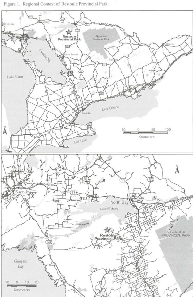
Enlarge Figure 1. Regional context of Restoule Provincial Park (PDF)
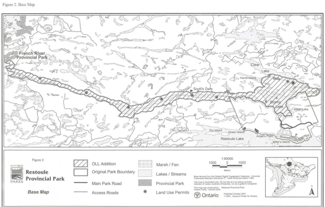
Enlarge figure 2. Base map (PDF)
4.0 Park objectives
There are four distinct objectives that provide specific direction for the management of Ontario’s park system: Protection, recreation, heritage appreciation and tourism. Restoule Provincial Park contributes to the achievement of all four objectives.
4.1 Protection objective
To protect the significant elements of Restoule Provincial Park’s natural, cultural and recreational landscape.
Area of significance within Restoule Provincial Park have been identified through zoning, and are protected by Provincial Park management policies. Research in the park will be encouraged to foster a greater awareness of park resource significance. The impact of management activities and recreational use will be monitored for environmental effects.
The Ontario’s Living Legacy park addition (Stormy Lake/Restoule River corridor) provide increased protection for natural features. It also creates an ecological corridor linking Restoule Provincial Park to other protected areas such as, French River Provincial Park and Grundy Lake Provincial Park. Ecological corridors allow wildlife to move freely between areas important to their lifecycle and for the interaction of different populations, thus helping to ensure the preservation of genetic integrity and biological diversity.
4.1.1 Life sciences
Plant communities in the original portion of the park are primarily second growth maple/beech and mixed-wood forests. There is good representation of oak mixed-wood forests, lowland hemlock/cedar forests, maple and mixed ash swamp forests, upland pine/oak barrens and various wetland communities. The southwestern part of the park provides good representation of mature beech/maple forests, hemlock forests and a nutrient-poor fen/bog complex. The section of the Restoule River in the original portion of the park supports a variety of mature wetland communities. Several plant species in the park occur in or near the northern limits of their continuous range.
The Stormy Lake/Restoule River OLL addition corridor is dominated by pine, mixed conifer and intolerant hardwood stands, and various wetland aquatic ecosystem types. A reconnaissance inventory of this area was conducted in autumn 2000.
4.1.2 Earth sciences
The moderately rolling terrain of Restoule Provincial Park is strongly in influenced by the underlying bedrock. Ridge and cliffs of exposed bedrock are interspersed along Stormy Lake and in the park’s interior. The highest point in the park, an abrupt cliff over 60 meters in height, borders Stormy Lake. The bedrock in the park is typically mantled by a thin veneer of sandy till, with pockets of moderately deep till and glacial lake deposits.
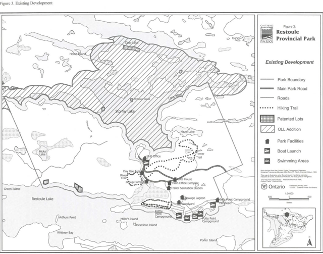
Enlarge figure 3. Existing development (PDF)
The park is situated in the geological Grenville Province of the Canadian Precambrian Shield. The bedrock type found in the park are over a billion years old, and consist primarily of grey migmatitic gneisses. Gneisses are banded rocks. Which are formed through a history of melting and stretching. The park provides locally significant represent at ion of these rocks.
Ontario was repeatedly glaciated during the last two million years. Evidence of this in Restoule Provincial Park includes deposits of glacial till, pockets of glacial lake deposits and glacially polished and striated bedrock surface. Where these sediment meet the shoreline of Stormy Lake erosion has created small sandy beaches. Inland, in the campgrounds above Stormy Lake, small wave-cut terrace, mark the ancient shorelines of glacial Lake Algonquin, a lake that occupied the Huron and Georgian Bay basins some 10,000 years ago. These beaches, both modern and ancient, are of local significance.
Restoule Provincial Park’s Ontario’s Living Legacy addition is a linear band of shoreline that forms bedrock ridges. Small rock outcrops line most of the shoreline. Many of the outcrops display significant glacial erosion surfaces, evidence of the last glacial period in the area. The bedrock exposures in the OLL addition are in the form of high ridges above the Restoule River and low relief outcrops on the north shore of Stormy Lake. Within the Ontario Provincial Park system, the geological features observed in the OLL addition have regional significance.
4.1.3 Cultural resources
The park contains three sites warranting Historical zone designation. One site marks the location of a former homestead. The remains of a root cellar on the site confirms the indication. The fire tower represents a period of fire management and past fire detection methods when people were stationed at these lookouts to monitor forest fires. Another Historical site marks the location of a former settler’s cabin.
The last study documenting the cultural history of the park was published in 1971. An archeological study to locate remnants from the homesteading era and to determine the true significance of the Historical sites will be encouraged. The park will also be assessed for historic Native presence. New park additions will be assessed for their cultural significance.
4.2 Recreation objective
To provide a variety of outdoor recreation opportunities ranging from high-intensity day-use to low-intensity backcountry experiences.
The recreation objective will be achieved through the designation of appropriate zoning to areas offering access to facilities and areas of significant recreation potential. Management policies will guide the development of recreation opportunities without compromising values associated with the protection objectives. Research on park visitation, park use, local facility development and business trends will be encouraged.
Restoule Provincial Park currently provide camping facilities, a day-use picnicking area, two swimming areas, two hiking trails, a combination hiking/biking trail, and boat launches to meet the recreational demands of, and to attract park usage by campers and day visitors. Annually, the park offers approximately 104,300 camping and 23,100 day-use opportunities.
Restoule Provincial Park is primarily a destination park for family camping. Campground facilities include:
- 275 campsites approximately 97 of these equipped with electricity;
- Group camping sites;
- Comfort stations equipped with showers; and
- Vault privy toilets located throughout the campgrounds.
Walk-in campsites are also available for a more rustic camping experience. An area is being kept in reserve for future campground development if required. This area is located in the campground Development zone (D1) and is presently used for hiking and biking. There is high potential for additional interior backcountry camping in the undeveloped western portion of the park. The western and northeastern portions of the original park offer high potential for future hiking or biking trails. Boat launches on both Stormy and Restoule Lakes offer easy access to the adjacent waterways for all park visitors.
The Stormy Lake/Restoule River corridor links Restoule Provincial Park with French River Provincial Park, offering a protected recreational and ecological corridor. This park-to-park link is part of a traditional canoe route, increasing the potential for high quality backcountry canoe and kayak camping experiences. Some interior campsites are already established dong the shores of Restoule River and Stormy Lake. Potentially. Restoule Provincial Park could serve as a staging area for canoe and kayak trips to other provincial parks, such as, Grundy Lake and Killarney Provincial Parks, both which are linked by water routes largely protected as provincial park.
4.3 Heritage appreciation objective
To provide opportunities for exploration and appreciation of the outdoor natural and cultural heritage of Restoule Provincial Park.
Exploration and appreciation of Restoule Provincial Park will be encouraged and be compatible with and complementary to the protection of the natural and cultural resources of the park. Opportunities will be provided for unstructured exploration of the park and the surrounding area. This will be facilitated by supplying visitors with up-to-date and accurate information on the park’s natural, cultural and recreational resources, and through self-guided trails and displays. Opportunities will be provided for structured exploration of the park and the surrounding area through the Natural Heritage Education (NHE) program.
4.4 Tourism objective
To provide Ontario residents and nonresident visitors with opportunities to discover and experience Restoule Provincial Park, and distinct regions of the province.
Restoule Provincial Park provides day use and destination camping facilities to Ontario residents and non-resident travelers alike. Staff are involved with promotion of local activities and services.
A previously mentioned, Restoule Provincial Park serves as a staging point for long canoe excursions. The Restoule River links the park with French River Provincial Park, thereby increasing the potential to discover other unique provincial features within the region.
Restoule Provincial Park is an important part of the Restoule/Loring tourist area and contributes to the local and provincial economies. Each year park visitors spend money while visiting the park and surrounding area and Ontario Parks spends money for the operation and capital development of the park. These expenditures are estimated to be approximately $850,000 annually. The Provincial Gross Output, or the total value of goods and services sold by businesses province wide during a normal year of operation in support of Restoule Provincial Park is estimated to be $2.2 million. The park makes a significant contribution to the local and provincial economics. Additionally, the expenditures associated with Restoule Provincial Park supports the equivalent of 24 person years of employment annually.
5.0 Park boundary
The boundary for Restoule Provincial Park is currently outlined in Ontario Regulation 951, Schedule 50, Appendix B, The park bounded by Clear Lake to the north and Restoule Lake to the south. Stormy Lake and Restoule River comprise the majority of the new OLL park addition. Restoule River also bisect the centre of the original park boundary. There is a 100 metre water boundary extending into Restoule Lake. Several patented collage lots situated along the shores of Clear, Stormy and Restoule Lakes are encompassed by the park.
The Stormy Lake/ Restoule River corridor OLL addition has increased the total area of the park such that it exceeds the 2000-hectare minimum for a Natural Environment class park. The boundary configuration and area numbers will be confirmed upon regulation of the addition under the Provincial Parks Act. The addition consists of the portion of the Restoule River between Stormy Lake and the French River, with a 200-metre setback from the water’s edge. The addition also includes all of Stormy Lake. The addition provides a navigable riverine link and ecological corridor between Restoule and French River Provincial Parks.
6.0 Zoning
Zoning delineates areas based on their management requirements and is therefore a key tool in management planning. Zoning also identifies natural and significant features of a park. A Natural Environment class park may contain up to six types of zones, including: Nature Reserve. Natural Environment, Access, Development, Wilderness and Historical. Restoule Provincial Park contains all the types of zones with the exception of Wilderness (refer to Figure 4).
6.1 Nature reserve zones
Nature Reserve zone identify significant earth and life science features requiring special management to protect these features. The primary purpose of Nature Reserve zones is to meet protection and heritage appreciation objectives. Development in Nature Reserve zones is limited to trails, necessary signage, minimal interpretive facilities and research and management facilities.
Four Nature Reserve zones have been designated in Restoule Provincial Park to protect natural features for their fundamental value interpretation and scientific study.
NR1 Hicks Lake/Beaver meadow complex (54 hectares}
This zone provides representative wetland plant assemblages ranging from sphagnum bogs to hedge meadows. The complex provides an excellent educational and research resource because of a range of habitats found within a small area. The stream/beaver meadow complex provides representation of a bedrock -controlled creek, escarpment, hemlock, and beaver meadow communities. This entire zone is sensitive to foot traffic.
The construction of boardwalks across the stream system leading from Hicks Luke to Restoule River may be permitted in order to support the development of interior hiking trails in the southwestern portion of the park and to reduce the impact from foot traffic. Trails will be limited in this zone.
Significant vegetation species in this zone include a provincially rare moss, Sphagnum contortum, and the provincially rare Marsh St. John’s-Wort, Triadenum virginicum. Efforts shall be made to ensure the protection of these species and to prevent disturbance.
NR2 Restoule River wetlands (38 hectares)
This zone includes the north/south portion of the Restoule River that bisects the original park, leading from Stormy Lake to Restoule Lake. This zone also includes the wetlands associated with the Restoule River.
The wetlands situated along the Restoule River represent a range of aquatic communities and include a sedge meadow, open water aquatic marshes and a Black Ash/Red Maple swamp. There is also good representation of sand spit plant communities. Fresh-water sponges grow in profusion in these waters.
The use of motorized vehicles, including motorboats, is not permitted within Nature Reserve zones.
Viewing platforms may be constructed along the lnngc of this zone to enhance the wildlife viewing potential in the park, and to encourage appreciation of the river and wetlands.
Figure 4: Zoning
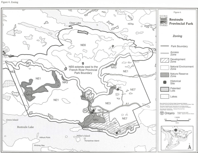
Enlarge figure 4: Zoning (PDF)
NR3 Natural sandy beaches (7 hectares)
These small natural beaches support a variety of bulrushes, sedges and other shoreline aquatic plants. Typical trees found here include hemlock, spruce, cedar and green ash. These sites provide good refuge for the continued survival and development of species assemblages that grow on natural beach environments. These sites also have a high interpretive value. The vegetation is highly sensitive to foot traffic and exploration of these areas will be discouraged. These beaches will not be developed for recreation purposes. The bulrush and sedge communities found here buffer the shoreline from wave action and therefore serve a major function in stabilizing the beaches.
NR4 Exposed bluff (6 hectares)
This area is toned Nature Reserve due to the sensitive nature of this steep rockface and fragile living conditions for plants able to maintain a foothold here. Research will be encouraged to determine the approximate age of the trees. Due to the nutrient-poor environment and extremely slow growing conditions, these dwarfed trees are potentially the most ancient in the park.
A viewing platform may be constructed at the peak or the bluff to reduce erosion and impacts on surrounding vegetation. Significant vegetation species in this zone include the provincially rare lichen, Cladina arbuscula, and the regionally rare Creeping Juniper, Juniperus horizontalis. Interpretive signs will be installed to identify the significance of the bluff and the sensitivity of the associated vegetation.
Rock climbing is not a permitted activity within the Nature Reserve.
6.2 Historical zones
Historical zones are intended to protect important examples of Ontario’s past, especially those related to the land and natural resources.
Three specific Historical sites have been identified. Management of these sites will be consistent with policies associated with Historical zones. A cultural inventory for the park and an archeological inventory for all Historical sites will be encouraged to search for artifacts and further evidence of the historical significance of Restoule Provincial Park. These studies will help determine the extent of each Historical site.
H1 Fire tower
This structure is remnant from an era of fire detection when people were posted at tower to monitor for forest fires. The Stormy Lake fire tower was constructed in 1954 and stands over 30 metres tall.
This method of fire detection was eventually abandoned in favour of aircraft fire patrols. The tower would require extensive upgrading if it is to be opened as a public viewing tower.
Interpretive signs will be displayed at this location to explain the history of fire towers.
H2 Grawbarger Homestead
This is believed to be the site of the house from the Thomas and Marian Grawbarger homestead, an Ottawa Valley couple who settled in the Restoule wilderness in 1880. Little physical evidence of any structures remains. The presence of hops growing on a slope close to the site marks what is believed to be the location of the house. A foundation of a root cellar from the Grawbarger farm potentially dates as far back as 1881. Upon completion of further research, this zone may be expanded to encompass any other evidence from the homesteading era.
H3 Putt’s Cabin
The site of Putt’s cabin is located in Putt’s Point Campground, named after the settler. It is believed the duration of his settlement was relatively short. The cabin was built sometime between 1870 and 1880. The only remaining evidence is a depression in the ground between campsites 227 and 229.
Campsites 227 and 229 will not be considered for any expansion or upgrades until a study on the site has been completed. Should further study reveal historical significance, the two camp sites will be closed and rehabilitated.
6.3 Development zones
Development zones provide access and accommodate large numbers of people with services for day-use and camping activities. Development zones are delineated for various intensive facility based recreational activities. Development permitted includes campgrounds, traits, roads, washrooms, visitor control structures, commercial, administrative, management and Natural Heritage Education facilities.
D1 Development zone (74 hectares)
This zone includes three existing campgrounds: Putt’s Point, Kettle Point, Bell’s Point and their associated facilities, such as vault privies and comfort stations. Several walk-in campsites are situated in the southern portion or Bell’s Point Campground.
The two beaches in the park designated for swimming are situated along the shoreline of the campgrounds. An area along the Restoule Lake shoreline adjacent to Bell’s Point Campground will continue to serve as the primary pet beach in the park.
Future development in Restoule Provincial Park must be consistent with park business planning, and will be subject to park management planning policies. Proposed development for this zone may include the following:
- Campsites: Management may require the development of a limited number of campsites to allow upgrading or rehabilitating of existing campsites; to provide barrier free campsites; to provide additional sites with electricity; or, to provide other site amenities;
- Boat Launches: There is currently one boat launch located at each campground to offer easy access to the adjacent waterways. These facilities may be upgraded as needed and as funding permits, to provide optimum boat launching facilities or to increase docking space;
- Future Campground: An area is reserved for a future campground if the demand exists and requires its development (see Figure 5). This area is presently used for hiking and biking;
- Park Facilities: Other facilities located m this zone include the main park office, gate house, trailer dumping station, staff house, maintenance yard, wood yard and sewage Facilities in this zone may be upgraded or replaced as needed and as funding permits:
- Park Store: This zone may accommodate a park retail outlet to consolidate services currently offered by the park;
- NHE Facilities: This zone may accommodate the relocated Natural Heritage Education office.
D2 Development zone (7 hectares)
This zone contains group camping facilities, day-use area. Park Superintendent residence, Natural Heritage Education office and the Stormy Lake boat launch.
The group camping area is currently near optimum operating level. Sites may be expanded within the Development zone boundaries if required and the demand exists. Group campsites will not encroach on the H2 Historical site, and a site-specific archeological assessment will be conducted prior to any group camping area expansion.
D3 Development zone (3 hectares)
This zone encompasses a sandpit, formerly used as an aggregate source in facility upgrading and refurbishing projects. The site is presently used for storage of maintenance materials.
Sand will not be extracted from this site for park development projects. Sand and gravel will be imported from local pits and quarries outside park boundaries to meet demand as required.
Figure 5: Proposed development

Enlarge figure 5: Proposed development (PDF)
6.4 Access zone
This eight-hectare zone consists of the main road corridor leading from the eastern park boundary to the Stormy Lake boat launch, and through the D1 and D2 Development zones. The Access zone will offer minimum facilities and will support the use of and provide access to adjacent zones.
Vegetation may be managed in the Access zone to ensure safe vehicular travel. Consideration shall be given to ensure the continued survival of the locally rare plant species Meadow Horsetail, Equestrian pretense, found in this zone.
There will be limited access through this zone during the shoulder/off-season months. The corridor leading to Stormy Lake will allow year round access; however, it will not be maintained during the winter months. The main park road leading past the gatehouse will be gated during the off-season.
6.5 Natural environment zones
Natural Environment Zones incorporate aesthetic landscapes and support lowintensity recreation activities. Development permit ted includes backcountry camping sites, recreational trail signs necessary for route identification, minimal interpretive facilities and temporary research and management facilities. While the primary focus of a Natural Environment zone is protection of flora and fauna, emphasis is placed on high quality, low intensity recreational and educational experiences, utilizing the natural development within this zone.
Being the largest zone component in the park, the Natural Environment zone provides the land base for extensive recreational activities and a buffer between the Development and Nature Reserve zones.
NE1 Natural environment (616 hectares)
This zone also includes the park’s original 100-metre water boundary along Stormy Lake, and along a portion of Restoule Lake. Present recreation activities occurring on these water bodies are compatible with this type of zone.
The NE1 zone may accommodate several shoreline backcountry camping sites. These sites would be accessible primarily by canoe. Some interior sites may be accessible by proposed interior trails.
An interior hiking/biking trail is proposed for chis zone in the southwest portion of the park. Figure 5 illustrates the proposed future development within Restoule Provincial Park. An existing four-kilometre trapper’s trail will be used as the main section of trail.
NE2 South-western park boundary (35 hectares)
This zone provides representation of typical upland beech, maple, basswood forests and upland and lowland hemlock communities of the Great Lakes - St. Lawrence Forest. This area also contains a mix of representative northern and southern flora, providing good interpretive value. The variety of ferns, clubmosses and the occurrence of orchids along the trails are of special interest. The locally rare Silvery Spleenwort, Athyrium thelypterioides, is found in this zone. Trails other than the existing trapper’s trail will not be developed in this zone in order to protect the natural values of vegetation communities found here.
NE3 Fire tower trail (76 hectares)
Along the trail in this zone are representative upland Red Oak/ juniper/ lichen barrens, which is an uncommon plant community type in the park. Also found are Sugar Maple, White Birch, American Beech, mixed tolerant hardwood/ hemlock, and cedar/ hernlock forests. There are small wetlands and ponds, as well as representation of both northern and southern Ontario flora in the forests and wetlands. A Red Pine plantation was established on abandoned agricultural land for soil stabilization purposes. This plantation is located adjacent to the Access zone leading to Stormy Lake boat launch, where it borders Natural Environment zone NE7. The variety of ferns, clubmosses and orchids along the hiking trail are of special interest. Collectively, these features provide good interpretive value.
There is a need to reduce the numerous worn pathways at the crest of the Fire Tower trail, adjacent to the lockout. Foot traffic is causing soil compaction and vegetative disturbance. Trail management techniques will be used as required. Other significant vegetation species in this zone include:
- The locally rare Silvery Spleenwon, Athyrium thelypterioides, and Leatherwood, Dirca palustris;
- The regionally rare Creeping Juniper, Juniperus horizontalis, and Northern Bog Violet, Viola nephrophylla;
- The provincially rare lichen Cladina stellaris.
Effort shall be made to ensure the protection of these species. A site specific plant inventory will be conducted prior to any trail expansion in this zone.
NE4 Walk-in sites (9 hectares)
Several walk-in campsites are situated in this zone, representing potentially the most scenic camping the park has to offer. Priority will be given to maintaining a low-impact use in this area maintaining a low-impact use in this area. No new sites will be developed in this zone. These sites are currently not operating, however consideration will be given toward opening these sites for public use, this zone. These sites are currently not operating, however consideration will be given toward opening these sites for public use.
NE5 Campground wetland, beach and shoreline (29 hectares)
This wetland is a cattail marsh with excellent interpretive values. The small cattail marsh provides an accessible and relatively resilient wetland for group or self-guided interpretation. Potential exists for the addition of a boardwalk for recreation and interpretation purposes.
A small natural sand beach is situated in this Natural Environment zone, adjacent to the wetland. It will be used for low intensity nature interpretation and recreation purposes only. Aquatic vegetation associated with this beach will continue to progress undisturbed and will not be removed.
A section of shoreline adjacent to the campgrounds is included in this zone. This stretch of shoreline runs from the easternmost park boundary along Restoule Lake to Angels Point, adjacent to the Nature Reserve Zone NR3.
NE6 Stormy Lake/Restoule River corridor (1413 hectares)
This area has been added to the park through Ontario’s Living Legacy Land Use Strategy. The addition serves as a recreational and ecological link between Restoule Provincial Park and French River Provincial Park, and will support low density/low impact canoe accessible backcountry shoreline camping. Previously established campsites will be assessed for their suitability as interior sites. Upgrades to the existing sites and addition of new sites will be implemented accordingly.
The primary access to the park addition is through the Stormy Lake boat launch. This location will continue to serve as the primary access point for the Stormy Lake/Restoule River corridor.
Scott’s Dam along Restoule River has been used as a water level control structure for many years. It will continue to be monitored by park staff and maintained by MNR North Bay District. The dam is one of only two structures spanning the river. An existing portage by-passing the dam will remain accessible. Other portages may be identified and maintained and/or developed as determined suitable by park management.
The other structure spanning the river is a bridge used by the adjacent Dokis First Nations community for forest access north of Restoule Provincial Park. This bridge will not be utilized for park operation purposes. The bridge will not be promoted nor encouraged as a park access point.
NE7 Natural environment zone (238 hectares)
This zone includes a large portion of the eastern half of the original park. The NE7 zone may support new hiking or biking traits, and serves as a buffer to park Nature Reserve zones.
7.0 Resource stewardship policies
The park’s natural and cultural resources will be managed in accordance with the general planning and management policies for Natural Environment class parks in Ontario Provincial Parks Planning and Management Policies (1992) and the Ontario’s Living Legacy Land Use Strategy (1999). Supplementary policy direction is provided in the following.
7.1 Fisheries management
Fishing activity in park waters, including Stormy Lake, the water boundary and the Restoule River OLL addition, will be subject to regulations outlined in the Fish and Wildlife Conservation Act, Federal Fisheries Act. Provincial Recreational Fishing Regulations, and the North Bay District Fisheries Management Plan. Some ongoing fisheries management practices that may occur in park waters include: lake surveys, habitat assessment and inventories; habitat improvement: fish population and tacking assessments; creel surveys; and, Walleye and Lake Trout stocking programs.
Restoule, Stormy and Clear Lakes, as well as Restoule River provide excellent recreational fishing opportunities for species such as Muskellunge. Northern Pike. Walleye and bass. Responsible fishing and use of these water bodies be promoted through appropriate park activities and information mediums.
Baitfish harvesting will be permitted within original and new park boundaries, except in Nature Reserve zones. This activity will be phased-out of Nature Reserve zones by 2010 (except for aboriginal use, subject to applicable legislation and regulation). No new baitfish operations will be permitted within the park.
7.2 Wildlife management
7.2.1 Hunting
Hunting of large game, small game and waterfowl is permitted in the Natural Environment zones NE1, NE2 and NE6 only.
Hunting of all game is permitted only during the first Tuesday following Thanksgiving until April 30 the following year. This applies to both the original park and the new Ontario’s Living Legacy addition, as follows:
- Hunting in the NE1 and NE6 zones also includes all waters contained within the zones;
- Hunting in zones other than those outlined is prohibited.
- Hunters will be permitted to transport unloaded encased and locked firearms during regular provincial hunting seasons.
- Hunting regulations will comply with those outlined in the Fish and Wildlife Conservation Act and Provincial Hunting Regulations.
- Where bear hunting is permitted in the park. a license to Provide Bear Hunting Services may be issued, renewed or transferred.
7.2.2 Trapping
In accordance with the policy for trapping in the Ontario’s Living Legacy Land Use Strategy (1999), trapping will be permitted to continue indefinitely within original park boundaries as well as the new Ontario’s Living Legacy addition. Trapping will not be permitted in park Nature Reserve zones (except for trapping by Status Indians exercising treaty rights) and as such, will be phased out of Nature Reserve Zones by 2010. Transfers of active licenses, permits or other types of authorization will be permitted subject to a review of Potential impacts and the normal types of transfer or renewal conditions that apply within a protected area. No new operations will be permitted. If a commercial license is revoked, surrendered or unallocated, all portions of the registered trapline within the park will be rescinded from the trapline’s legal description.
Occasionally, animals may become a nuisance and connect with park management objectives. Trapping of nuisance animals may be conducted under the direction or the Park Superintendent.
All operations and development activities undertaken within the park will have due regard for all animal species, their habitat requirements and movements.
7.3 Vegetation management
A Vegetation Management Plan will be developed with a view to maintaining visitor safety, park aesthetics and to perpetuate natural succession processes. Brushing and clearing operations will be conducted under the direction of the Park Superintendent. The Vegetation Management Plan will include direction to control and eradicate non-native plant species and/or noxious weeds. Efforts will be made to ensure that non-native plant species are not introduced.
The Vegetation Management Plan will also guide the management of the Red Pine plantation situated in Natural Environment zone NE7, between the Access zone split, and the bordering Natural Environment zone NE3 (Fire Tower Trail). The plantation will be thinned to allow for natural regeneration to occur, and will create a greater diversity of plant species and habitat for wildlife species. Trees cut during the plantation thinning process may be used for facility repairs and upgrades, as wood chips for trails, or for other similar projects.
Trees in the park will not be cut for the purpose of providing firewood. Windfall Crees will be left to decompose naturally, unless they pose a health or safety threat, or are an interference to regular park operation.
Vegetation may be planted for campsite regeneration and for increased naturally vegetated buffers between sites. Only species native to the park will be used.
In the Natural Environment zones, plant succession will progress unimpeded.
Where safety hazards exist along traits, vegetation may be removed in association with brushing operations and routine trail maintenance.
Natural succession in Nature Reserves will progress unimpeded. Vegetation obstructing trails in this zone will be hand tended.
Commercial timber harvesting is prohibited within park boundaries. The occurrence of insects and diseases native to the forest region, in which the park is situated, is recognized as an integral component of the park’s ecology. Insect infestations and diseases in Historical and Nature Reserve zones will normally be allowed to progress naturally. If such outbreaks threaten values which the zone was defined to project, they will be controlled.
Measures to control non-native insects and disease that infest vegetation may be permitted in all zones where aesthetic or natural values are threatened. Where control is desirable and feasible, it will be directed as narrowly as possible to the specific threat to minimize the effect on other elements of the park environment. Biological rather than chemical controls will be used whenever possible. If required, control measures will be prescribed in the Vegetation Management Plan.
7.4 Fire management
Given the capital investment in facilities within the park and the degree of development adjacent to the park, natural and human-caused fires in all zones will be suppressed. Fire suppression techniques which have the least residual impact on the park’s natural environment will be used whenever possible.
7.5 Landforms
The main beach along Restoule Lake, within the Development zone, has been replenished in the past using and from external sources. Wave action and longshore drift have caused beach erosion. ln order to maintain a quality recreation beach, various rehabilitation techniques may be utilized, such as adding sand as required to enhance aesthetics and to encourage recreational use. Beach improvements are subject to approval by the Department of Fisheries and Oceans, who is responsible for assessing the impact of shoreline projects on fish habitat and spawning areas.
7.6 Mineral exploration
Mineral exploration and mining are not permitted within the original boundaries or the OLL addition of Restoule Provincial Park.
7.7 Cultural resources
An in-depth cultural inventory of the park will be encouraged. The last historical assessment of the park was completed in 1971. Cultural history identified will he depicted through the park’s NHE program.
The fire tower may be upgraded if required to maintain structural integrity, or to facilitate the construction of stairs and viewing platforms.
7.8 Recreational resources
The existing hiking trails are heavily used, especially during peak park operating season. Measures to control trail erosion will be implemented. Added surfaces, such as crushed rock screenings or wood chips may reduce compaction of soil and damage to exposed roots. Trails will be clearly marked and signed to reduce deviation from the main route. Boardwalks, bridges and stairs may be constructed along trails to assist with erosion control and to ease difficulty of extreme terrain. Trails are discussed further in Section 8.3.1.
Priority will be placed on enhancing viewing areas on all trails when possible. Platforms may be constructed along the River Trail to provide viewing opportunities of the Restoule River Nature Reserve. Platforms may also be constructed around the perimeter of Restoule River Nature Reserve (NR2) and at the peak of the lookout on Pire Tower Trail. A boardwalk through the campground marsh (NES) will also be considered.
8.0 Operations policies
Operations policies deal with topics such as Natural Heritage Education, recreation management, the provision of recreation and tourist cervices, business planning and research.
The Park Operating Plan will be updated regularly to provide park staff with the necessary information required to operate the park on a day-to-day basis. In addition to addressing operations policies, the plan will include such topics as budget, staffing, maintenance schedule, enforcement and emergency services. This plan will be consistent with the approved Ontario Provincial Parks Operating Standards, and will be reviewed annually and updated as required.
8.1 Natural Heritage Education
The purpose of Natural Heritage Education (NHE) in Restoule Provincial Park is to provide park visitors with opportunities to learn through interpretive programs and facilities, thereby increasing visitor awareness of Restoule Provincial Park’s significant natural, cultural and recreational features.
Restoule Provincial Park presently offers a seasonal level of NHE service. This level of service designation reflects:
- Significance of natural features in the park;
- The quantity of park visitors (occupancy and visitation rates);
- Proximity of the park to a major tourist area;
- Number of education programs offered; and
- The number of park visitors attending programs and utilizing the park’s recreation and interpretive facilities.
Programming will include the three components of Natural Heritage Education: information, interpretation and recreation. The park Natural Heritage Education Plan will be evaluated annually and revisions made as required.
8.1.1 Information
Information will be conveyed to park visitors through a variety of mediums, including: park brochures and tabloids, elf-use trail guides, interpretive signs and displays, and through programs developed and conducted by the park NHE staff. Interpretive information will identify park features, management, facilities and local attractions.
8.1.2 Interpretation
Interpretive themes for Restoule Provincial Park are divided into major and minor. While park interpretation may include any aspect of the park, the following will be the primary focus.
Major
- Earth Science: Canadian Shield and Grenville Province features. Emphasis will be placed on the series or faults and dykes that make up the Restoule River.
- Life Science:
- Cliff-face ecology. Emphasis will be placed on the sensitivity of the cliff face feature and the fragile living conditions for plant species.
- Wetland communities. Restoule Provincial Park incorporates a wide variety of wetlands, which include: rivers, streams, bogs, fens, swamps and marshes.
Minor
- Historical / Cultural:
- Logging history
- Homesteading
- Resource Management: Fire response
8.1.3 Recreation
Interpretive programs will be developed to enhance the camper’s recreation experience in the park and to provide the opportunity for recreational skills development. This may take the form of programs exploring park interpretive themes by canoe or trail. Self-guided traits already exist, providing a recreational hiking experience. Emphasis will be placed on maintaining and enhancing existing trails and developing new hiking or biking opportunities. Outdoor skills enhancement activities will be developed where possible. These will include such activities as canoeing instruction and a variety of outdoor skills oriented interpretive programs.
8.2 Research
Scientific research by qualified individuals will be encouraged in Restoule Provincial Park. Approved research activities and facilities must be compatible with the park’s protection objective. Research must comply with Provincial Park Policy on research activities in parks, and will require written approval of the Park Superintendent. Research activities will also conform to the Ontario Parks Research and Information Strategy, which identifies corporate priorities with respect to current science, research and information needs.
Emphasis for future research projects at Restoule Provincial Park will be placed on: a study on the ecology of the Exposed Bluff Nature Reserve (NR4) to determine the age of the potential old growth trees established on the rock face, and a cultural resource inventory to search for remnant artifacts from the homesteading era.
8.3 Recreation management
During the average camping season, there are roughly 48,000 visits to Restoule Provincial Park; the majority of visitors are campers. According to park surveys, most visitors had previously visited the park, and the majority of campers surveyed made the park their main trip destination. Restoule Provincial Park can therefore be classified as a destination park. Day Visitor and Camper Surveys suggest that the main recreational activities in which park visitors participate include swimming, hiking, viewing scenery, fishing, boating and biking.
8.3.1 Trails
Restoule Provincial Park has two maintained hiking trails and a combined hiking/biking trail. The total length or this network is approximately 10 kilometres. The Fire Tower Trail is self-guided and approximately seven kilometres in length. The one kilometre River Trail provides for a more leisurely hiking experience. There is a two kilometre hiking and biking trail located in Development Zone D1; this area is becoming kept in service for future campground development if required.
Recent Camper and Park Day Visitor Survey support the need for new and improved traits within Restoule Provincial Park. New trails may be established to increase the recreation potential or the park, and to provide opportunities for park exploration and Resource appreciation. Proposed new traits (also see Figure 5) are as follows:
- There is an existing trapper’s trail bisecting the south-western portion of the park. This trait will be properly identified, marked and be made available for park visitors. The trait is approximately four kilometres in length and could potentially be used for day hiking or biking experiences, or as a staging point for interior camping. New backcountry camping opportunities could be provided through hike-in access to interior sites situated along the Restoule River. Access would be provided from secondary traits deviating from the existing trapper’s trail, leading to the river edge;
- A new bicycle trail may be developed in the Natural Environment zone NE7 to sustain increasing popularity of this sport. This new trait would be more challenging and would be geared toward more experienced riders. The bike trait loop would be a minimum or five kilometres in length.
The Ontario’s Living Legacy addition will be evaluated for its potential to support interior traits. Traits could provide access to proposed interior campsites, or serve as an access for park maintenance and emergency response staff. Proposed hiking and biking trails will be located where possible on old trails and/or roads. Hiking trails will be monitored for erosion, and mitigation measures will be implemented as required. A feasibility study will be prepared prior to the implementation of new traits to determine if they are an appropriate addition to the park’s trail infrastructure. New traits will be assessed for their suitability through approved site plans prior to construction. Site-specific life science, earth science and cultural inventories will be conducted to ensure protection of natural park values.
8.3.2 Backcountry camping
Restoule Provincial Park has high potential for providing backcountry camping. The relatively undeveloped southwestern half of the original park, in conjunction with the undisturbed shoreline, offers opportunity for hike-in and canoe accessible sites.
The Stormy Lake/Restoule River corridor will be evaluated for potential to support interior canoe accessible campsites. Location and number of sites will be determined following a more indepth analysts of the area. Existing campsites will he used where appropriate.
A backcountry implementation plan will be prepared prior to the development of any interior sites. This plan will assess existing sites for their suitability; propose new sites for development; and establish an implementation arrangement.
Two separate walk-in campgrounds, on one of which presently used, are located in the eastern half of the original park in zone NE4 and D1. In order to maintain the present integrity of the sites, no new development will occur in these areas.
8.3.3 Winter use
Presently there are no winter activities or services offered in the park, with the exception of ATV and snowmobile access to designated areas.
8.3.4 Recreation and tourist services
Canoeing continues to be a popular activity among park visitors, according to park user surveys. In response to this, canoe and other non-motorized watercraft rentals may be offered in the park. With the increase of bicycle use in Restoule Provincial Park, bicycles are presently being offered on a rental basis.
8.3.5 Adjacent lands and waters
Environmentally sensitive use of adjacent Crown lands and waterways will be promoted.
8.3.6 Private recreation camps
Eight Land Use Permits (LUP’s) in the form of private recreation camps, are located within park boundaries along the Stormy Lake/Restoule River OLL addition.
Existing authorized LUP’s will be allowed to continue and may be eligible for enhanced tenure, but not purchase of the lands. Enhanced tenure is defined as an upgrade in the nature or type of tenure, and/or an extension in the term of the tenure. Establishment of new private recreation camps will not be permitted within park boundaries.
Recreation camp LUP holders may apply for facility improvements, but may not increase size or capacity of the camp. No new roads will be developed for access to camps in the OLL addition. Any patented land located within the park boundaries will remain patented land. Ontario Parks may consider purchasing the properties in the future on a willing-seller, willing-buyer basis only.
8.3.7 Motorized vehicles
During the annual seasons of May 1 until Thanksgiving Monday, motorboats will be limited to motors of 10 horsepower or less along the Restoule River portion of the Ontario’s Living legacy park addition (Natural Environment zone NE6). During the seasons of the first Tuesday following Thanksgiving until April 30 the following year, motorboats in this same area will be limited to motors of 40 horsepower or less. Exemptions may he granted by the Park Superintendent for specific circumstances. This may include park management and operations, law enforcement and emergency response. Motorboat horsepower restrictions will ensure greater protection for significant and sensitive aquatic flora and fauna species and habitats.
ATV’s and snowmobiles are not permitted within original park boundaries and are permitted only on trails and routes within the OLL addition (Natural Environment zone NE6) designated by the Park Superintendent. Exemptions may be granted for specific circumstances through permission by the Park Superintendent. This may include operation and management of the trapper’s trail in zone NE1 and NE2: as a means of access through the park’s Access zone; and, for access to private recreation camps and cottages located within park boundaries.
ATV’s and snowmobiles will be permitted in the portion of the Access zone leading along Highway 534 to the Stormy Lake boat launch only during the first Tuesday following Thanksgiving until April 30 the following year. Motorized vehiclcs are not permitted in Nature Reserve zones.
8.4 Marketing
A Marketing Strategy, in conformance with the Park Business Plan, will be prepared to promote Restoule Provincial Park. This strategy will establish direction:
- To promote Restoule Provincial Park as a recreation resource to the local communities;
- To demonstrate Restoule Provincial Park as an integral element of the tourism market benefiting from and bringing benefits to the local business sector; and,
- To ensure that Restoule Provincial Park is included in promotional activities associated with tourism in local communities.
Objectives outlined in the Park Business Plan include:
- Attract new visitation from immediate markets, within a 150-km radius:
- Contact local schools for visitation and partnership projects;
- Boost visitation in both shoulder and peak periods;
- Promote day-use visitation;
- Encourage greater exposure of the local economic community to park visitors.
Emphasis on marketing will be focused on existing and new facilities and services as they materialize: for example, backcountry camping, canoeing and new trails will be promoted through published documents, such as the park tabloid, and incorporated into visitor related activities and programs. Marketing will be used to increase the length of visits to Restoule Provincial Park by promoting park use in shoulder seasons, promoting new trails, camping experiences, services and facilities. Emphasis will be placed on attracting outdoor groups to use new hiking trails, bicycle trails, backcountry camping experiences and canoe excursions using Restoule Provincial Park as a drop-off and pick-up location.
9.0 Development policies
The purpose of this section is to provide a concise development concept for Restoule Provincial Park, and to identify priorities for new development and the redevelopment or existing facilities.
9.1 Camping and alternative accommodation
Campsites subject to high use will be rehabilitated. Site rehabilitation processes, such as planting native vegetation species for buffers or to speed the rehabilitation process, may be required.
Interior campsites will be gradually phased-in upon completion of the management planning process. Suitable existing sites will be utilized first, and upgraded if required in order to provide proper site amenities, including a tent pad, fire pit, toilet pit, etc.
The park business plan will address the feasibility and environmental effects of establishing yurts and fixed roof accommodations in the park. If approved, these facilities would be situated in Development zones D1 and D2. Favorable locations include the existing campgrounds and the reserve campground.
9.2 Internal roads and parking
Park roads and parking areas may be upgraded as required. ln the case of increases in beach, day-use, or interior camping opportunities, new parking areas may be added within the Development zones. No new roads will be developed in the Ontario’s Living Legacy park addition.
9.3 Comfort stations
Two comfort stations are situated within the park, one in each of Kettle Point and Putt’s Point Campgrounds. A third comfort station may be added in Bell’s Point Campground. Shower facilities may he added to existing buildings as demand requires. Comfort stations will also he upgraded or replaced as required.
9.4 Day use facilities
Docking and boat-launching facilities along Restoule and Stormy Lakes may be refurbished and upgraded. Additional docking slips may be added, depending on the level of use.
New trails proposed for the Restoule Provincial Park include a four kilometre hiking trail and a five kilometre biking trail. Those trails are discussed in more detail in section 8.3.1.
9.5 Utilities
Utility systems such as the water system, sewage system and electrical system are adequate for the present needs of the park. Upgrades to these utilities will be implemented as needed and as funding permits.
9.6 Park maintenance and operations facilities
Restoule Provincial Park’s maintenance facilities are presently sufficient for the requirements of the park. Upgrades to the maintenance infrastructure will be implemented accordingly and as funding permits.
The main park office is currently situated within the maintenance compound. A new park office constructed in conjunction with the gatehouse facility at the entrance to the park is required in order to accommodate more efficient visitor access control during the spring and autumn seasons.
9.7 Natural heritage education facilities
The park’s NHE office is presently located adjacent to the day-use area. It serves as the summer headquarters for the NHE staff, and facilitates a variety of programs and displays. Since it is not a convenient walking distance from the campgrounds and due to its lack of parking space, it is recommended that the NHE office be relocated to a more appropriate area, central to the campgrounds. An outdoor amphitheater may be constructed at the new location of the office to accommodate a greater variety of programming. New seasonal and permanent educational displays will offer greater educational experiences for park visitors, reflecting the park’s level of activity.
9.8 Park store
A park retail outlet may be considered for Restoule Provincial Park in order to consolidate services that are currently provided by the park. Current existing services include the sale of ice, park merchandise and recreational rental items, such as bicycles and canoes. A park retail outlet operation may be considered once:
- A feasibility study and business case are prepared to determine if this is an appropriate facility for Restoule Provincial Park; and,
- An appropriate site is selected in an area central to all campgrounds and that will net negatively impact natural features of the park. The park retail outlet may also be incorporated into an existing structure, such as the current park office within the maintenance compound, or within the proposed new park office location, which includes the main gatehouse.
Ontario Parks will continue to be sensitive to the interests of neighboring private sector businesses. Park management will enter into consultation to seek approval for the expansion of the services provided by the park retail outlet should those new services be deemed to be in direct competition with existing local service providers.
10.0 Implementation strategy
The projects and activities described in this plan and listed below will be implemented depending on the availability and allocation of funding each year, and according to the priorities established by Restoule Provincial Park. Prior to implementing these projects, MNR will undertake additional evaluations and consultations as required to meet policy and Environmental Assessment Act obligations.
10.1 Resource stewardship
- Prepare study on the Exposed Bluff Nature Reserve;
- Prepare Park Cultural/Archeological Study;
- Prepare Vegetallon Management Plan;
- Implement interpretive signs at fire tower;
- Implement erosion control and monitoring measures on trail system.
10.2 Development
- Evaluate and develop new hiking and bicycle trait network, following the development of a trail implementation plan/feasibility study;
- Evaluate OLL addition for trait potential;
- Evaluate site locations and develop/upgrade water accessible interior campsites;
- Prepare business plan for yurts and fixed roof accommodation;
- Construct new park office;
- Evaluate alternatives and prepare site plan for the relocation of the NHE office and the construction of an outdoor amphitheatre;
- Implement park viewing platforms and boardwalks;
- Upgrade comfort stations.
10.3 Operational/administration
- Prepare Marketing Strategy;
- Maintain Park Operating Plan;
- Implement motorboat engine size restrictions;
- Develop park retail outlet operation;
- Maintain boundary markings.
10.4 Social and economic impact analysis
As noted in section 4.4. Restoule Provincial Park makes a significant contribution to the economies of the Restoule community. Patterson and Hardy Townships and the Province of Ontario.
The MNR Social and Economic Impact Model is used to estimate the impact of the expenditures associated with Restoule Provincial Park.
The average initial total expenditure by park visitors and by Ontario Parks to operate Restoule Provincial Park is approximately $850,000 annually. The average Provincial Gross Output (the total value of goods and services sold by businesses during a normal year of operations) is approximately $2.2 million. Restoule Provincial Park also supports the equivalent of roughly 24 person years of employment annually. The development of new hiking and biking trails, new interior campsites and roofed accommodation has the potential of increasing recreational activity during the peak operating season in the summer, as well as encouraging more visitation in the spring and autumn shoulder seasons. An increase in the number of visitors will increase the contribution to the local economy, and new development will help support the area’s tourism infrastructure.
11.0 Public consultation
An Invitation to Participate was issued in June 1998 to solicit input for the management planning process. The invitation consisted of newspaper notices, bulletin board notices throughout the park, and newsletter mailings to the public, adjacent landowner, and stakeholder groups. A notice was also posted to the Environmental Bill of Rights Environmental Registry inviting participation. A mailing list was compiled containing names of those who expressed, in addition to those on Ontario Parks’ mandatory mailing list.
Two public information sessions were held in July 1998 to address early in the planning process, concerns of park users, adjacent landowners and interest groups. One session was held in the village of Restoule for the Citizens of the local community, and one session was held in Restoule Provincial Park for park visitors. Notice of these meetings was outlined in the Invitation to Participate. A Terms of Reference was written prior to the information sessions and distributed upon request.
A Background Information File was compiled in August 1998 and was made available upon request at the Restoule Provincial Park Office, North Bay MNR District Office and Ontario Parks Central Zone Office. Invitations to review the file were issued, and consisted of newspaper notices, newsletter mailing to those on the mailing list, and a notice was posted to the Environmental Bill of Rights Environmental Registry.
The Preliminary Management Plan stage was initiated with postings in the park during the summer of 2001 to encourage participation in the planning process. The management planning mailing list was increased to include those on the MNR North Bay District’s mailing list for the Ontario’s Living Legacy Restoule Provincial Park addition.
The Preliminary Management Plan was released to the public on August 15, 2001, with and open house August 28, 2001. Comments on the preliminary plan were accepted until September 28, 2001. A newspaper notice preceded the release of this document, and an Environmental Bill or Rights posting coincided with the release date.
The predominant themes in the comments have been reflected in the contents of this management plan. Public consultation for the preliminary plan resulted in the following changes: The management planning mailing list was increased to include those on the MR North Bay District’s mailing list for the Ontario’s Living Legacy Restoule Provincial Park addition.
The Preliminary Management Plan was released to the public on August 15, 2001, with an open house August 28, 2001. Comments on the preliminary plan were accepted until September 28, 2001. A newspaper notice preceded the release of this document, and an Environmental Bill or Rights posting coincided with the release date. The predominant themes in the comments have been reflected in the contents of this management plan.
Public consultation for the preliminary plan resulted in the following changes:
- A horsepower limitation on the Restoule River will be implemented, rather than a seasonal motorboat restriction;
- Changes in zoning have been applied in order to clarify areas of the park open to hunting. Through this, the hunting zone was extended to include a traditional hunting ground in the eastern-half of the original park. The north/south portion of the Restoule River bisecting the original park has been included in the NR2 Nature Reserve zone. This meets the level of protection intended for this aquatic environment;
- The proposed non-OLL park addition located m the southeast corner of the park has been removed;
- Clarification has been provided with regard to ATV and snowmobile use within park boundaries.
The release of this approved Management Plan will also include:
- A public notice informing the public of a final opportunity to review the plan for a period of 45 days after its formal release: and,
- A posting of a Decision Notice on the Environmental Bill of Rights Environmental Registry.
12.0 References
Department of Fisheries and Oceans, Fisheries Act, R.S.C c.F-14, 1985.
Frey, E. and Duba. D., Draft Earth Science Invention. P153 Restoule Addition. 2000.
Hope, Douglas. The Historical Background of Restoule Provincial Park, Ontario Ministry of Natural Resources, 1971.
Kershaw, H.M., Life Science Inventory for Restoule Provincial Park, Devlin Consulting Services. 1997.
Ontario Ministry of Natural Resources, A Research and Information Strategy: Setting Priorities. Occasional Paper Number 2. Ontario Parks, Planning and Research Section. 1997.
Ontario Ministry of Natural Resources, Base Map Information. 1:50,000. North Bay District. 1998.
Ontario Ministry or Natural Resources, Bear Management Areas and Traplines Map, 1:50,000. North Bay District, 1998.
Ontario Ministry of Natural Resources, Environmental Assessment in Ontario Provincial Parks: An Interim Field Reference for Self Corporate Policy and Planning Secretariat, Huntsville, 1994.
Ontario Ministry of Natural Resources. Fish and Wildlife Conservation Act, S.O. 1997. C.41.
Ontario Ministry of Natural Resources, Hunting Regulations Summary 2001. Queen’s Printer for Ontario, 2001.
Ontario Ministry of Natural Resources. Land Tenure Map, 1:50.000. North Bay District, 1998.
Ontario Ministry of Natural Resources, Loring Deer Yard Map, 1:50,000. North Bay District, 1998.
Ontario Ministry of Natural Resources, North Bay District Fisheries Management Plan 1987-2000, Queen’s Printer for Ontario, 1989.
Ontario Ministry of Natural Resources. North Bay District Land Use Guidelines, 1983.
Ontario Ministry of Natural Resources, Ontario’s Living Legacy Land Use Strategy, Queen’s Printer for Ontario, 1999.
Ontario Ministry of Natural Resources, Ontario Provincial Parks Management Planing Manual, Park Operations Section, Provincial Operations Branch, Toronto, 1994.
Ontario Ministry of Natural Resources. Ontario Provincial Parks Operating Standards, Provincial Parks and Natural Heritage Policy Branch. Toronto, 1992.
Ontario Ministry of Natural Resources, Park Statistics 1993- 1997. Ontario Parks. Park Operations and Development Section. Peterborough.
Ontario Ministry of Natural Resources, Recreational Fishing Regulations Summary 2001, Queen’s Printer for Ontario, 2001.
Ontario Ministry of Natural Resources, Resource Allocations Map, 1:50,000. North Bay District, 1998.
Ontario Ministry of Natural Resources, Resource Values Map, 1:50,000. North Bay District, 1998.
Ontario Ministry of Natural Resources, Restoule Provincial Park Interim Management Statement, 1986.
Ontario Parks, OMNR, A Reconnaissance Life Science lnventory of the Proposed Addition to Restoule Provincial Park, Huntsville, March 2001.
Ontario Parks, OMNR, Provincial Park Day Visitor Survey Summary Tables 1996, Planning and Research Section.
Ontario Parks, OMNR, Provincial Park Camper Survey Summary Tables 1996, Planning and Research Section.
Ontario Parks, OMNR, Restoule Provincial Park Addition Recreation Resource lnventory Report, Huntsville, March 2001.
Patten, Bruce, Restoule Provincial Park Geological Report, Ontario Ministry of Natural Resources, 1972.
Spek, C.M., Restoule Provincial Park Earth Science Checksheet. Ontario Parks Central Zone Planning and Research Section, 1997.