Rushing River Provincial Park Management Plan
This document provides policy direction for the protection, development and management of Rushing River Provincial Park and its resources.
Park Management Plan
Ministry of Natural Resources
Hon. Vincent G. Kerrio
Mary Mogford
Deputy Minister
Note: This document has been scanned and formatted, and therefore is slightly different from the original version. -March 2002
©1986, Queen’s Printer for Ontario
Printed in Ontario, Canada
Additional copies of this publication are obtainable at the
Ministry of Natural Resources, Kenora District Office,
Box 5080, Kenora, Ontario. P9N 3X9.
Telephone 807-468-9841
Approval statement
As one of the most popular parks in the province, Rushing River Provincial Park has special significance. Its location as Ontario’s westernmost park on the Trans Canada Highway provides the travelling public with an exemplary introduction to Ontario’s provincial park system.
We are pleased to approve the Rushing River Provincial Park Management Plan, as official policy for the management and development of this park. The plan reflects this Ministry’s intent to protect natural and cultural features of Rushing River and maintain and develop high quality opportunities for outdoor recreation and heritage appreciation for both residents of Ontario and visitors to the Province.
Signed by:
D.R Johnston
Regional Director
Northwestern Region
N.R. Richards
Director
Parks & Recreational
Areas Branch
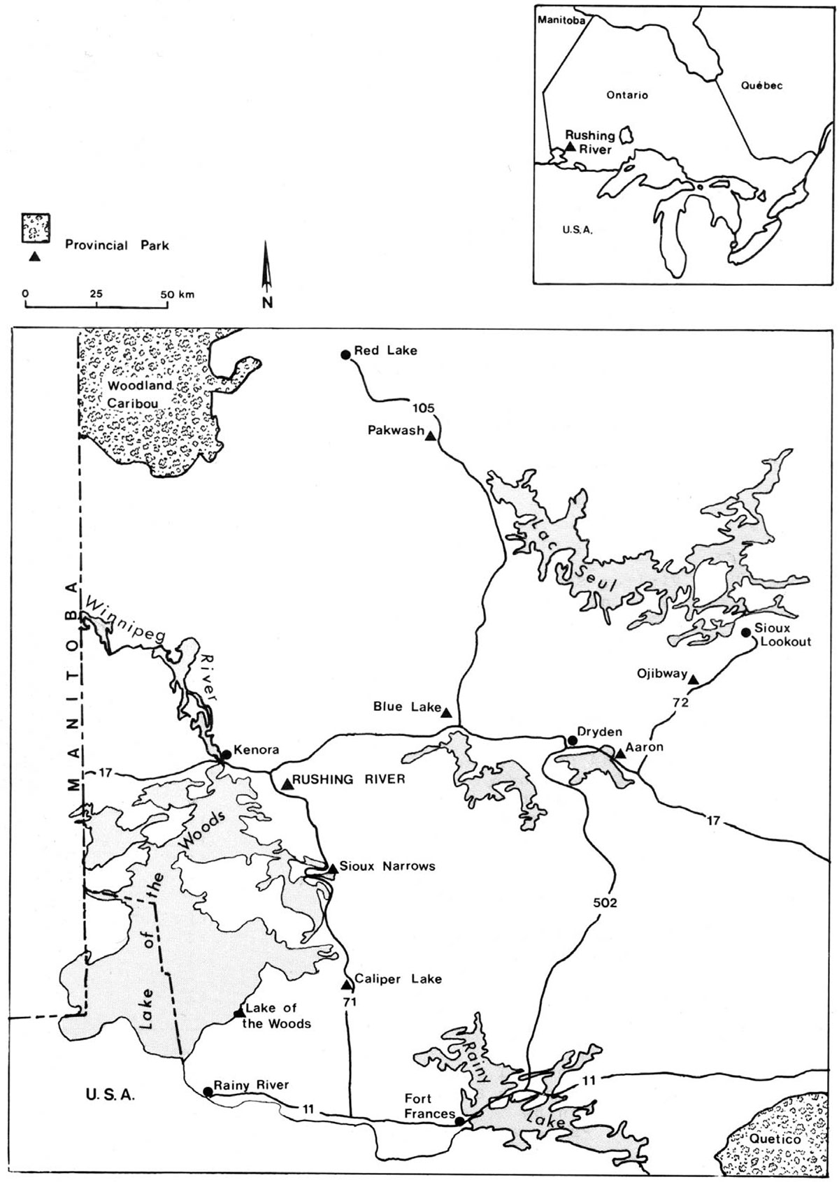
Figure 1: Regional Context

Enlarge Figure 1: Regional Context
1.0 Introduction
Rushing River Provincial Park is scenically located along a series of rapids on Rushing River and on the shore of Dogtooth Lake. The park is situated approximately twenty kilometres southeast of Kenora on Highway 71 (Figure 1). It was put into regulation in September 1958 at a size of 190 hectares. Management planning for Rushing River Provincial Park began with the collection of resource information in 1977 and continued in 1983 and 1985. The Background Information was published in September 1985 and the Preliminary Plan was distributed in February of 1986. Public comment was solicited and considered in the formulation of this management plan. It has been developed consistent with the Kenora District Land Use Guidelines.
Typical of much of the Canadian Shield country of Northwestern Ontario, the park is located on moderately broken granite bedrock with little soil cover, under a tree canopy of jackpine and aspen. These characteristics are representative of Hills' Kenora Site District of the Lake of the Woods Site Region. Although the park exhibits typical boreal vegetation, it is in the Northern Transition Zone of the Great Lakes-St. Lawrence and Boreal forests, and species native to the southern forest grow in the park. Bogs in various stages of development are found within deep bedrock depressions. In contrast to the hot, dry conditions of the bedrock outcrops, low lying areas have dense undergrowth and a cool microclimate.
Rushing River Provincial Park offers a wide range of recreation opportunities including walking, cross-country skiing, swimming, boating and fishing. Recreation facilities in the park include two interpretive trails, seven groomed cross-country ski trails, three docks, two boat launches, three beaches and 191 campsites. The campground has 38 electrical sites, a comfort station and showers. Rushing River flows through the day use area, which is a very popular picnic spot for both residents of the area and tourists travelling the highway.
The park’s interpretive program and its facilities, including the museum and interpretive trails, provides both recreation and education opportunities.
Rushing River is an intensively used park with an 80% - 90% occupancy rate during July and August. The majority of campers are families from Manitoba.
2.0 Classification
Rushing River is classified as a Recreation Park. Recreation Parks are areas which support a wide variety of year-round outdoor recreation opportunities for large numbers of people in attractive surroundings. This classification recognizes that Rushing River offers a number of alternative activities in which park visitors can participate, in a setting of picturesque river rapids flowing from a lake surrounded by rocky shores and jackpine stands. The management plan for Rushing River has been developed in accordance with the recreation class guidelines as set out in the Ontario Provincial ParksPlanning and Management Policies.
3.0 Goal
The goal of Rushing River Provincial Park is to provide a wide variety of recreation opportunities within the scenic natural setting provided by Rushing River and Dogtooth Lake and to maintain the natural beauty of the park.
4.0 Objectives
Ontario provincial parks have four objectives: to protect the province’s natural and cultural resources, to provide recreation opportunities, to provide the opportunity to appreciate the province’s heritage and to promote tourism. The role of Rushing River Provincial Park in fulfilling these objectives is outlined below.
4.1 Protection
- to protect provincially significant elements of the natural and cultural landscape of Ontario
The bogs and jackpine stands on bedrock outcrops are characteristic of this area of the province. The park is part of the transition zone between the Great Lakes-St. Lawrence and the Boreal forests and species typical of the southern forests such as Red Pine, are present in the park. These characteristics, along with cultural artifacts, like the museum, will be maintained through zoning and management policies.
Figure 2: Existing Development
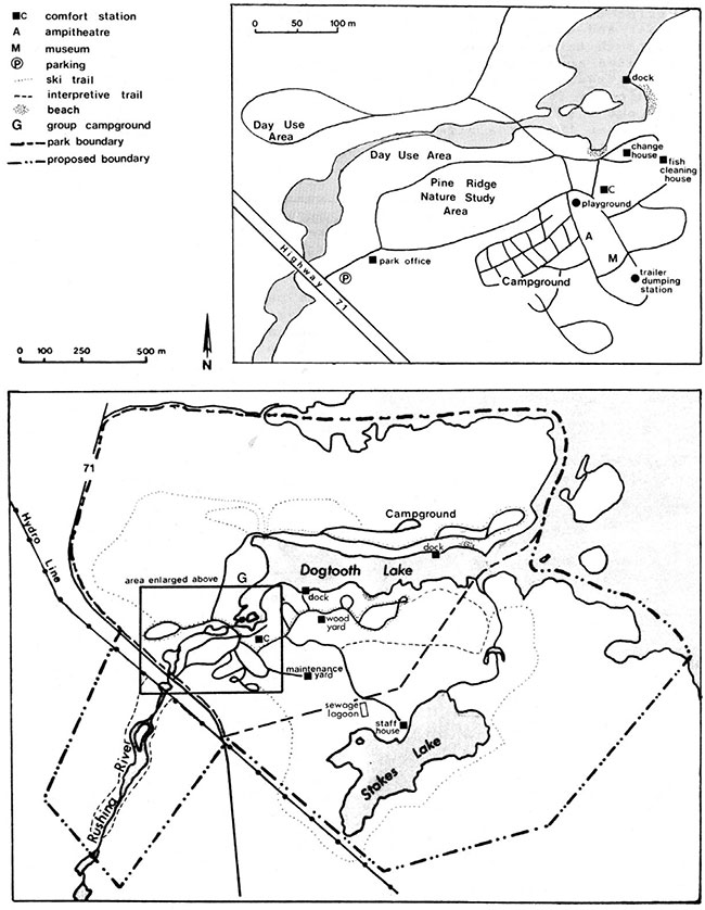
Enlarge Figure 2: Existing Development
4.2 Recreation
- to provide outdoor recreation opportunities ranging from high-intensity day use to low-intensity wilderness experiences
Rushing River Provincial Park annually provides the following recreation opportunities:
- Day Use: 15,000 user days
- Camping: 50,000 person nights
The park’s day use area takes advantage of the rapids of Rushing River to provide a scenic backdrop for the activities that are enjoyed in this area including picnicking and swimming. The campgrounds follow the shore of Dogtooth Lake and nestle amongst the jackpine and aspen which forest the park.
The park’s facilities contribute to the recreation objective by providing opportunities for both high and low intensity recreation in winter and summer.
4.3 Heritage Appreciation
- to provide opportunities for exploration and appreciation of the outdoor natural and cultural heritage of Ontario.
The visitor services program offers park users the opportunity to appreciate and learn about the natural and cultural features of the park through interpretive programs and self-use facilities.
4.4 Tourism
- to provide Ontario residents and out-of-province visitors with opportunities to discover and experience the distinctive regions of the Province
The park will provide day use and camping opportunities for travellers. It is an important weekend and vacation destination for the majority of its users who are from outside Ontario.
The park benefits the economy of the Kenora Region because of its high use by tourists from outside the province. The average camping group spends about $175.00 in the area during their stay. (O.M.N.R. 1983)
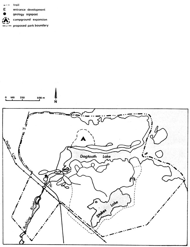
5.0 Boundary
The Lower Rapids area of Rushing River and the area around Stokes Lake, totalling 173 hectares, will be included in the park. The park facilities will then be consolidated as the staffhouse, sewage lagoon and some major parts of the trail system are outside the existing park boundary (Figure 2). The addition of these two areas will ensure their future use for low- intensity recreation and will provide expanded opportunities to interpret the park’s natural and cultural history.
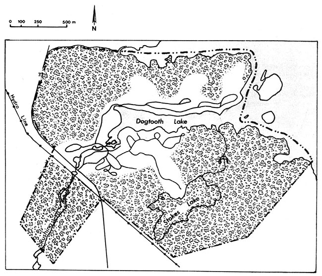
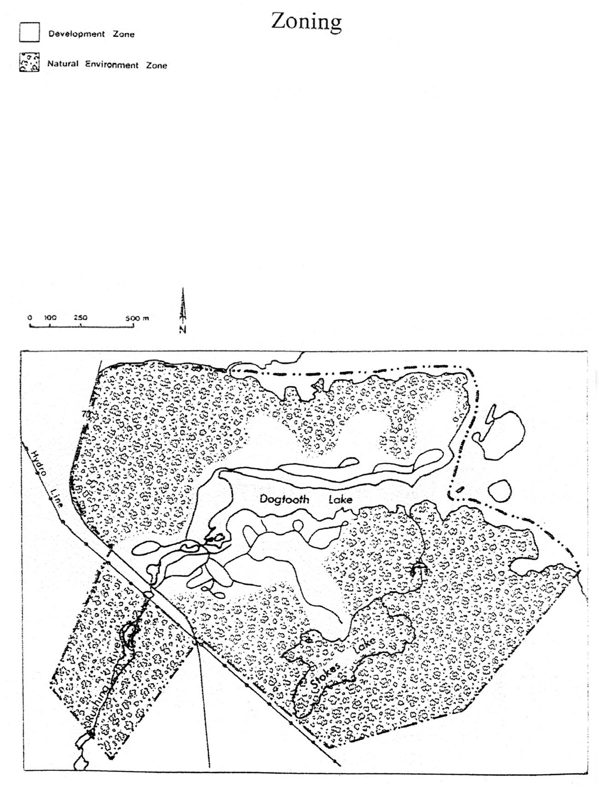
6.0 Zoning
Two types of zones are designated to guide the management of the park (Figure 4). A natural environment zone recognizes the parks natural features and the development zone recognizes those parts of the park, which are developed or are capable of supporting proposed development.
6.1 Natural environment zone
The natural environment zone comprises three areas of the park totalling 230 hectares. The zone protects areas sensitive to development and provides areas for extensive recreation. It will be managed to maintain each area’s natural character. Development will be limited to trails and minimal interpretive facilities.
One area of the zone covers much of the area in the north part of the park including jackpine uplands, a number of small bogs and other wetlands.
The second area covers the Lower Rapids area of Rushing River. This lush river valley setting with its cool microclimate is in marked contrast to the hot dry conditions of the jackpine uplands. This part of the river can be divided into two sections with differing characteristics. The upper part of the river is wide and slow moving with a sandy clay bottom. Vegetation along the river edge consists of grasses and sedges which provide an ideal habitat for waterfowl. The lower section of the river flows quickly over bedrock outcrops and has steep rocky banks.
Figure 3: Zoning
The third area includes Stokes Lake and some undeveloped shoreline on Dogtooth Lake. The marsh/bog environment of Stokes Lake has excellent interpretive potential.
6.2 Development zone
The development zone (88 ha.) covers all areas of existing and proposed development including the campgrounds, day use areas, park roads and administrative facilities. In this zone is the Pine Ridge Nature Study Area where the integration of Boreal and Great Lakes Forests is evident. This area will undergo development only for interpretation.
Parts of the development zone exhibit symptoms of overuse including exposed tree roots and soil compaction. These areas require rehabilitative work including vegetation plantings and soil rehabilitation. This zone will be managed to ensure that it is maintained such that it will continue to provide the opportunity for an enjoyable recreational experience.
7.0 Resource management
The park will be managed in accordance with the ministry’s planning and management policies for recreation class parks. Specific direction, where needed to meet the requirements of Rushing River, is outlined below.
All planning and management will recognize that the different resource components are interrelated and that an integrated approach will be required in order for the park to achieve its objectives.
7.1 Landform
Natural environment zones have been established to protect the bedrock uplands and the bogs of the park. Within the development zone, the Pine Ridge Nature Study area will be protected. Measures to reduce erosion on the ridge will be undertaken.
Levelling of campsites and adding sand to maintain the beaches in their present state will continue on an ongoing basis in order to maintain the park’s recreational facilities.
7.2 Vegetation
All wild fires burning within the park will be suppressed in order to protect park values. Wherever feasible fire suppression techniques will be used which will have a minimal impact on the park environment.
Where forest insects or disease seriously threaten park values, spraying may be permitted. In such a case, spraying will follow Ministry of Natural Resources and Ministry of Environment guidelines. The use of biological insecticides will be preferred.
In the development zone, forest rehabilitation and tree planting of native species will be undertaken to improve buffering between campsites and to rehabilitate areas devoid of natural regrowth. Where specific trees are necessary for aesthetics, shade or buffering, they may be fenced to protect them from beaver activity. A vegetation management plan will be developed to guide these projects.
In the natural environment zones, forest succession will progress unimpeded. Where safety hazards exist along trails, trees will be removed in association with regular trail maintenance.
7.3 Water
Dogtooth Lake is the source of the park’s water supply. Water will continue to be tested according to approved Ministry testing procedures.
The two dams on Rushing River will be maintained in a safe condition.
7.4 Wildlife
There will be no hunting in the park.
Where bears become a nuisance and pose a danger to park visitors, they will be removed from the park in live traps, or tranquilized by Fish and Wildlife personnel, and relocated away from the park.
If the activities of beaver threaten park values they will be trapped under the supervision of the Ministry’s Fish and Wildlife Branch.
7.5 Fisheries
Fishing for smallmouth bass, yellow pickerel and pike occurs in Dogtooth Lake. The park offers access to the lake with two boat launches and three docks. The Ministry’s Fish and Wildlife Branch is carrying out a program to improve the lake’s fishery. Projects include improvements to spawning beds and establishing a splake population in Dogtooth Lake.
7.6 Cultural resources
The park museum, built in 1935, will be protected and maintained in a sound condition. It will continue to be used as the park interpretive centre.
8.0 Visitor services
The visitor services program through the components outlined below, will give park visitors the opportunity to gain an understanding and appreciation of the park’s environment, its objectives, and how management will meet those objectives.
A Visitor Services Plan will be developed to guide the interpretation of the park’s natural and cultural history. This plan will be guided by the Regional Visitor Services Plan.
8.1 Information
Information concerning park facilities, visitor services programs, provincial park regulations and the natural and cultural environment of Rushing River will be conveyed by the use of brochures, Ministry publications, newsletters and by vocal contact between park staff and visitors. Points of interest, facilities and events in the area will be communicated to the park visitor. Visitor comments and reaction will be solicited by park staff.
8.2 Interpretation
Through printed material, self-use facilities and visitor services staff the park’s natural and cultural history will be interpreted. Self-guided exploration on park trails, in the Pine Ridge Nature Study Area and attendance at park interpretive programs will be encouraged. Park interpretation will focus on the following themes: glaciation of Precambrian granitic bedrock, marsh/bog ecology, river ecology, early contact site (natives-traders) and the transition forest.
Personal contact in the park museum, audio-visual programs at the amphitheatre and guided walks will be the major contact components of the visitor services program. Self-use of the museum, interpretive trails and displays will form the self-use components of the program.
The park museum will continue to be made available to school and other groups for nature study. Resource information will be made available to teachers and group leaders.
The current interpretive facilities will be expanded with the addition of a display post to describe the park’s geology, located in the day use area, and the addition of an interpretive/hiking trail around Stokes Lake.
8.3 Recreation
Staff will inform park visitors about recreation opportunities available to them. Outdoor recreation skills programming may be developed to assist visitors in fully experiencing those opportunities.
9.0 Marketing
Because Rushing River is used to capacity during July and early August, a marketing program will concentrate on encouraging campers to visit the park during June, late August and early September, when use is lower. The promotion of other parks in the area to relieve some of the pressure on Rushing River will also be part of the marketing program. Winter use of the park for cross-country skiing will be encouraged. A marketing plan will be developed to guide this program and it will recognize that the existing level of use during July and August will be maintained.
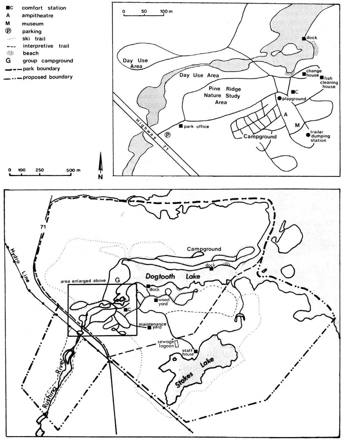
Figure 4: Proposed Development
Enlarge Figure 4: Proposed Development
10.0 Park operations
Park operations includes all day-to-day park activities including maintenance, enforcement, visitor services and gate operations. The objective of park operations is:
- to continue to manage and operate Rushing River at a high standard and in accordance with provincial park policy and procedures
A park operations plan or strategy will be updated as the park management plan is implemented. It will guide the day-to-day implementation of the projects outlined in sections 7.0 Resource Management, and 8.0 Visitor Services, as well as the activities mentioned above. The strategy will employ detailed guidelines and procedures for the management and operation of park programs, activities and facilities.
11.0 Proposed development
Development will proceed in order to meet the objectives of providing recreation opportunities, the opportunity for heritage appreciation and the promotion of tourism.
Development will be consistent with Figure 4. It will follow the guidelines outlined below and approved site plans.
11.1 Campground
A comfort station will be developed in the north campground area. This will require the construction of a sewage disposal system. Site planning will determine the best location for the comfort station.
Dependant on the results of site planning work the northside campground will be expanded to increase the number of walk-in and vehicle campsites. The site plan will determine the optimum number of sites and exact location of this expansion.
11.2 Trails/interpretive development
The Stokes Lake ski trail will be developed for use in summer as an interpretive/hiking trail. The trail will highlight parts of the Stokes Lake marsh.
To provide interpretation of some of the park’s geology an interpretive signpost will be erected in the day use area. The signpost will describe the geological history of a particular bedrock exposure.
11.3 Access & parking
The development of a vehicle circulation plan to improve access and decrease congestion at the park entrance will be undertaken.
Additional vehicle parking will be created in both campground areas. The location of parking lots will be determined by the circulation plan.
11.4 Recreation facility
A fish cleaning house will be constructed in the north campground area.
12.0 Implementation strategy
12.1 Project development
The programs and developments outlined in the management plan will be implemented based on the priority of each project. The projects to be completed in any given year will be based upon the availability and allocation of each year’s funding. All development work will follow approved site plans and Environmental Assessment Guidelines. All day-to-day park activities will be guided by a park operating strategy which will be updated as this plan is implemented.
Approved projects are listed in order of priority within the following operational categories.
Resource protection
- boundary change regulations
- vegetation management plan
- campsite rehabilitation plan
- vegetation planting and campsite rehabilitation (ongoing)
Visitor services
- Visitor Services Plan
- design and construct geological signpost
- plan and develop Stokes Lake Trail
Development
- circulation plan
- park entrance redevelopment
- additional vehicle parking
- comfort station and sewage disposal site plan
- comfort station and sanitary system construction
- campground site plan
- campground development
- fish cleaning house site plan and construction
12.2 Public consultation
The background information document and the preliminary management plan were made available for public review. Public comment on the preliminary plan was minimal. Those commenting were in favour of the plan. Some concern was expressed about the vegetation and soil deterioration in the day use area and campgrounds. A rehabilitation plan will provide prescriptions for correcting the present deterioration of these areas. Opinion varies on the development of more campsites at Rushing River Park. Expanding the campground will help to meet the need for more camping space. As well, it will provide the opportunity to give overused campsites a rest and allow time for their rehabilitation. Public comment on the approved plan will be welcomed.
12.3 Plan review
The management plan has a life span of twenty years and will be reviewed not less than 10 years following its approval and as the need arises. Data collection and environmental monitoring will be conducted regularly.
Bibliography
Beaudry, Marie-Ange and Joni Lavender Sexsmith. An Historical Research Report and Resource Inventory of Seven Provincial Parks in Northwestern Ontario Unpublished report. Northwestern Region: Ontario Ministry of Natural Resources, 1983.
Davidson, Joan. Brief Geology of Rushing River Provincial Park. Unpublished report. Kenora District: Environmental Planning Series, Ontario Ministry of Natural Resources, 1985.
Goddard, Allan W. Life Science Inventory of Rushing River Provincial Park. Unpublished report. Kenora: Environmental Planning Series, Ontario Ministry of Natural Resources, 1983.
James, T. et al. Impact of Recreation Use on Soil and Vegetation in Rushing River Provincial Park, Kenora, Ontario. Interim Report Phase B. Guelph: University of Guelph, 1976.
Kor, Philip S.G. Rushing River Provincial Park, Earth Science Inventory Checklist. Kenora: Ontario Ministry of Natural Resources, 1977.
Lambert, Peter J.B. The 1983 Archeological Survey of Seven Ontario Provincial Parks in the Kenora Region and Assessment of Archeological Resources in Adjacent Geographic Areas. Toronto: Park Planning Branch, Environmental Planning Series. Ontario Ministry of Natural Resources, December 1983.
Mackintosh, E.E. Impact of Recreation on Vegetation and Soils in Rushing River Provincial Park, Ontario. Report 0-X-290. Canadian Forestry Service and Ontario Ministry of Natural Resources, 1979.
Macleod, D. Archeological Survey of the Rushing River Site and Fox Island Site. Unpublished report Ontario Ministry of Natural Resources, 1971.
Noble,T. Rushing River Provincial Park Life Science Inventory Check—Sheet. Kenora: Ontario Ministry of Natural Resources, 1977.
Ontario Ministry of Natural Resources. Kenora District Land Use Guidelines . Kenora, 1983.
Ontario Ministry of Natural Resources. Lake of the Woods General Land Use Plan. Kenora, 1977.
Ontario Ministry of Natural Resources. 1983 Provincial Park Camper Survey Summary Statistical Report. Toronto: Parks and Recreational Areas Branch, 1983.
Ontario Ministry of Natural Resources. 1983 Provincial Park Day User Survey Summary Statistical Report. Toronto: Parks and Recreational Areas Branch, 1983.
Ontario Ministry of Natural Resources Ontario Provincial Park Planning and Management Policies. Toronto: Park Planning Section, 1978.
Ontario Ministry of Natural Resources. Northwestern Region Provincial Parks Visitor Services Plan, draft. Unpublished report. Kenora.
Ontario Ministry of Natural Resources. Rushing River Provincial Park Background Information. Kenora: Parks Branch, 1985.
Ontario Ministry of Natural Resources. A Topical Organization of Ontario History. Toronto: Division of Parks, Historical Sites Branch,1975.
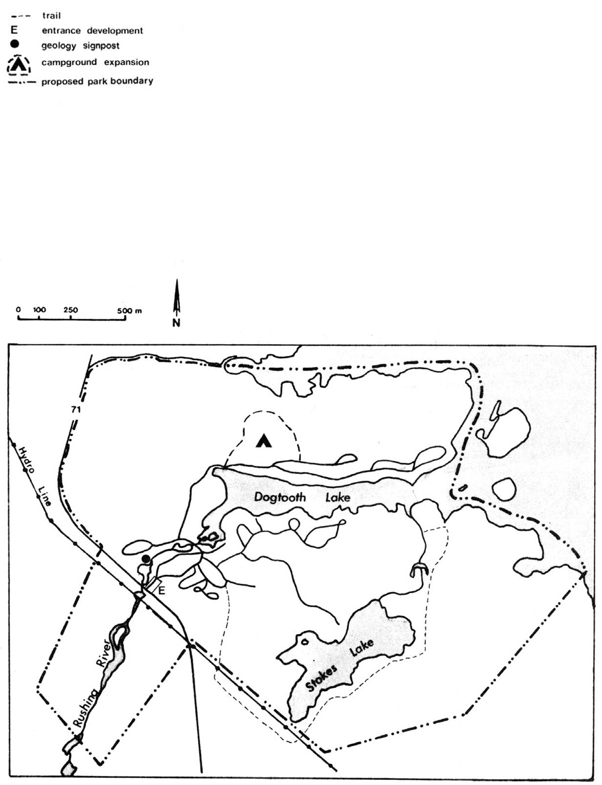
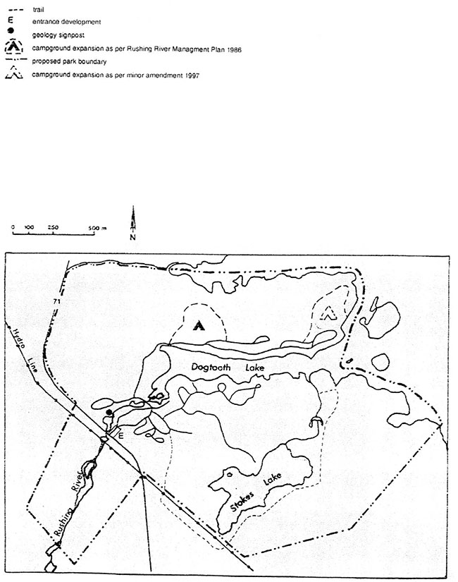
Minor amendment to rushing River Management Plan for campground expansion
Dec .18/97
1. Introduction: (proposed undertaking)
Develop 16 Hydro sites in the northeast corner of the park, 14 of which are new sites. The new campsite proposal lies within the Development Zone, as per the Rushing River Provincial Park Management Plan. However, in the P.M.P, campground development is proposed in an area west of the comfort station (section 1 1.0, page 10). We are deviating from the management plan because site investigations indicated that an area east of the comfort station was deemed superior for campsite development as per the following:
- proximity to power (construction Costs less)
- attractive lake sites
- flatter terrain for development of campsites and road (construction costs less)
- proximity to playground, dock ,comfort station and beach area
2) Project description:
The Proposed development includes clearing of trees for a new road and campsites complete with parking spurs, water lines and electrical pedestals. The campsites and road have been designed consistent with' Ontario Parks Development Standards". The road (R.O.W.), and Campsite use areas will be cleared this winter with final project completion prior to the operating season. This project has an approved business plan for capital funding, and is listed as a corporate priority
3) Existing environment:
Refer to the management plan, (section 1, page 2). Mike Jones (Natural Heritage Program) inspected the site for significant vegetative communities. There were no significant plant species with in the boundaries of development.
4) Conclusions:
The project does not have any unresolved environmental impacts, and should proceed as planned. The mitigation measures include grading of the road and campsites to provide for proper drainage and seeding/planting of all the disturbed areas as soon as possible after construction to minimize erosion and sedimentation
5) Public notification:
An information notice will be placed on the Environmental Bill of Rights Registry.
Steve Mason
Landscape Planner, Northwest Zone
Proposed development
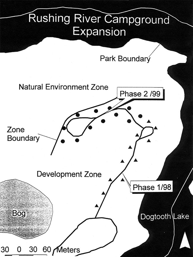
Zoning
Zoning map: 1

Zoning map: 2
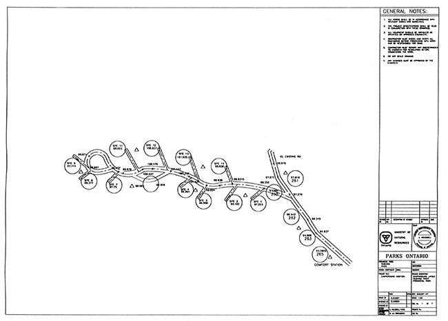
Site plan report
Campsite Development - Phase 2
Rushing River Provincial Park Jan./99
Introduction:
There have been numerous public requests to develop additional campsites in Rushing River Park.(Paul Sirman) The new campsite proposal lies within the Development Zone ,as per the Rushing River Provincial Park Management Plan (see Minor Amendment map "Zoning") These overnight facilities will include a mix of walk-in and car camping Opportunities with minimal amenities. (vault toilets, non-electrical)
Project description:
The proposed development includes clearing of trees for a new road, vault toilets, and 12 campsites complete with parking spurs. These campsites will be consistent with Ontario Parks Development Standards, which include fire pits, picnic tables, and gravel parking spurs. The road (R.O.W.) was flagged and surveyed in the fall 98. (Mason, Potter, Simian). Construction is scheduled for the spring of 99 with completion prior to the peak operating season. This project has an approved business plan for capital funding, and is listed as a corporate priority.
Existing environment:
Refer to the management plan, (section 1, page 2). Mike Jones (Natural Heritage Program) inspected the site for significant (rare) vegetative communities. There were no significant plant species within the boundaries of development. The lack of significant earth and life science features, relatively flat topography ,and minimal tree clearing were contributing factors in pin pointing this location. All campsites and parking spurs will be flagged by park staff prior to contractors operations commencing. Construction activities will occur only in the flagged areas to preserve the site.
Conclusions:
The project does not have any unresolved environmental impacts, and should proceed as planned. The mitigation measures include grading of the road, parking spurs, and campsites to provide for proper drainage and seeding/planting of all the disturbed areas as soon as possible after construction to minimize erosion and sedimentation. These additional sites should take some pressure off overused sites in the area. A campsite rotation strategy will be developed in the summer.
Public Notification:
An information notice will be placed in the local newspaper.
Steve Mason
Landscape Planner
Northwest Zone
Rushing River Gatehouse Replacement
Site plan report / March 2000
Introduction:
The existing gatehouse at Rushing River Provincial Park (circa 1956) needs to replacement to meet increased staff requirements and current building codes. Bat infestations, which pose potential health risks need to be eliminated as well. An initial inspection, with subsequent discussions in the summer 99 with Paul Sirman (Park Superintendent), J. Kolodziej (Coordinator Environmental Design), and S. Mason (Landscape / Site Designer) concluded renovations would be cost prohibitive. In addition to cost constraints, location was a major issue in terms of traffic circulation and safety. The existing location has poor site lines, its on the wrong side of the road for the drive-through concept and has limited back-up lane potential.
A site further east of the existing gatehouse on the north side of the entrance road would be a superior location for the following reasons:
- minimal site disturbance
- right side of road for drive-through concept
- 30% more back-up room for vehicles (improved circulation and safety)
- lies within the development zone and consistent with park entrance development as per the park management plan / 1986
- utilizes existing roads (minimal infrastructure cost)
- close proximity to power
- close proximity to septic field
- minimal rock blasting (soil depths)
Project description:
The proposed development includes construction of a 150 sq. metre ribbed block gatehouse complete with septic system and staff parking. These facilities will be consistent with Ontario Parks Design Guidelines. The construction of the facilities will be completed in the summer 2000.
Existing environment:
As previously mentioned the construction site lies within the development zone of the park adjacent to the park entrance road. Development in this area will not conflict with the Pine Ridge Nature Study Area where the integration of Boreal and Great Lakes Forests are evident. The area of construction will be flagged by park staff prior to contractor operations commencing. Construction activities will occur only in the flagged areas to preserve the site.
Conclusions:
This project does not have any unresolved environmental impacts, and should proceed as planned. The mitigation measures will include the following:
- grading to provide for proper drainage and seeding (native species) of all disturbed areas after construction to minimize erosion and sedimentation
- heavy equipment restrictions on site, and construction specifications will emphasize low impact building methods
Steve Mason
Landscape Planner, Northwest Zone.