Ryerson Township Forest Conservation Reserve Management Statement
This document provides policy direction for the protection, development and management of the Ryerson Township Forest Conservation Reserve and its resources.
Statement of Conservation Interest (C98)
Ministry of Natural Resources
Parry Sound District
Prepared with the assistance of:
Meteek & Company
Huntsville, Ontario
March, 2003
Approval statement
We are pleased to approve this Statement of Conservation Interest for Ryerson Township Forest Conservation Reserve (C98).
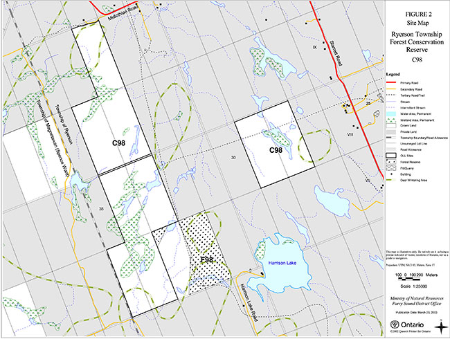
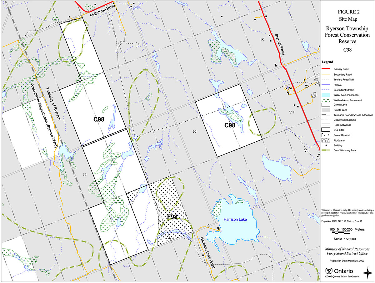
Ryerson Township Forest Conservation Reserve is located in the Township of Ryerson, in the Territorial District of Parry Sound. It lies about 15 kilometres west of the Village of Burk’s Falls and about two kilometres north of the Bear Lake Peatland Conservation Reserve (C85). The name of the site was changed from that identified in the Land Use Strategy (Harrison Lake Forest Conservation Reserve) to more accurately reflect its location.
Ryerson Township Forest Conservation Reserve comprises two separate blocks of land, the largest (most westerly) being approximately 272 hectares, and the other, approximately 81 hectares. A third block, of 50 hectares, is designated as a "forest reserve," and is immediately south-east of the conservation reserve.
This 353 hectare conservation reserve is located in Hills' ecological Site District 5E-8. It includes about a dozen identified combinations of representative vegetation and landforms. It is known as a winter concentration area for moose, and portions of it are occasionally used by white-tailed deer as a satellite of the Oranmore deer yard to the northwest.
Ryerson Township Forest Conservation Reserve is one of 378 new protected areas approved through Ontario’s Living Legacy Land Use Strategy, aimed, in part, at completing Ontario’s system of parks and protected areas.
During the "Lands for Life" planning process, the public was widely consulted and provided valuable input into what became Ontario’s Living Legacy Land Use Strategy. Comments received during that time, and during consultation related to the formal Public Lands Act (Ontario Regulation 805/94) regulation of the boundaries of this conservation reserve, were generally supportive of the protection of this area. Stakeholders who provided comment during the earlier consultation for this site were subsequently consulted regarding the draft Statement of Conservation Interest and their comments were considered in the finalization of this document.
This Statement of Conservation Interest provides guidance for the management of the conservation reserve and provides the basis for the ongoing monitoring of activities. It also provides direction for the adjacent forest reserve (F98). More detailed direction is not anticipated at this time. Should more complex resource management or conservation issues arise or significant facility development be considered, then a detailed Resource Management Plan will be prepared with full public consultation.
Ryerson Township Forest Conservation Reserve and its adjacent forest reserve are managed under the direction of the District Manager and the Parry Sound Area Supervisor of the Ministry of Natural Resources, Parry Sound District.
Approved by:
R. Griffiths
District Manager
Parry Sound District
Approved by:
Ron Running
Regional Director
Southcentral Region
1.0 Introduction
Ontario’s Living Legacy, the result of an extensive planning process that began in early 1997, culminated in the approval in July 1999 of a Land Use Strategy that identifies the intended strategic direction for Crown land, including the completion of Ontario’s system of parks and protected areas. This process, which included extensive public consultation, resulted in the recommendation for regulation of 378 new protected areas, including Ryerson Township Forest Conservation Reserve (C98).
Ryerson Township Forest Conservation Reserve is located in the Township of Ryerson in the Territorial District of Parry Sound. The conservation reserve comprises two separate blocks of land. The larger (westerly) block is approximately 272 hectares; the smaller (easterly) block is approximately 81 hectares. Immediately on the south east side of the westerly block lie two Crown lots (Lots 32 & 33, Concession 7, Ryerson), portions of which include a pre-existing mining lease and three mining claims, and which will be managed as a Forest Reserve (F98). The forest reserve is approximately 50 hectares in area. Should the aggregate permit be surrendered in the future through normal processes, and the mining claims and lease lapse, these portions of the forest reserve will be added to the regulated conservation reserve. All of the other lands surrounding Ryerson Township Forest Conservation Reserve are privately owned, and non e are a part of the conservation reserve.
This conservation reserve was selected because it contains a diversity of landform and vegetation features. It is an area of relatively low relief (shallow till and rock ridges) with tolerant hardwood forests on the uplands, and coniferous stands, black ash (Fraxinus nigra) stands and a variety of wetland types in the low areas. The conservation reserve also contains several "rich" sites (deep topsoils, fresh moisture regime, calcium in the soil) that include flora which is uncommon to regionally rare.
In particular, the area is noted to contain wintering sites for white-tailed deer (Odocoileus virginianus) and moose (Alces alces).
The area drains northerly through Ahmic Creek to Ahmic Lake and the Magnetawan River system.
Access to the conservation reserve is from the Midlothian Road, which connects to the north lot line of Lot 33 Concession 10, Ryerson, by way of a partially opened concession right-of-way. Access to the south side of the main block is from Midlothian Road to Starrett Road, south to Royston Road, then north to Harrison Lake Road to the southern lot line of Lot 31, Concession 7; from there, access is by foot, all-terrain vehicle or snowmobile into the conservation reserve. There is also a recreational trail which runs roughly north-south near the eastern boundary of the conservation reserve.
Conservation reserves are established under the authority of the Public Lands Act, Ontario Regulation 805/94. The Ryerson Township Forest Conservation Reserve was established by Ontario Regulation 148/02, an amendment of the Public Lands Act, on May 8, 2002. Forest reserves are not regulated but are bound by direction in the Ontario’s Living Legacy Land Use Strategy.
A Statement of Conservation Interest (SCI) is prepared under the authority of Procedural Guideline A – Resource Management Planning (PL. Procedure 3.03.05). The purpose of this SCI is to identify and describe the values of Ryerson Township Forest Conservation Reserve and the adjacent forest reserve (F98). The SCI also outlines the activities that currently occur within the conservation reserve and provides guidelines for the management of current and future activities in the context of protecting the natural, recreational and cultural values.
1.1 Background information:
| Name | Ryerson Township Forest Conservation Reserve (C98) |
|---|---|
| Site Region/District | Georgian Bay 5E-8 |
| OMNR Administrative Region/District/Area | Southcentral Region/Parry Sound District/ Parry Sound Area |
| Total Area (ha.) | 353 hectares |
| Regulation Date | May 8, 2002 (O. Reg. 148/02) |
| First Nations | Robinson-Huron Treaty |
| OBM map sheets | 20 17 6050 50450, 20 17 6100 50450 |
| Topographic Map | Magnetawan 31E/12 |
| UTM co-ordinates | 17T 61000 5046500 (Centroid Main Block) |
1.2 Representation
Earth science representation:
Bedrock
- Parry Sound Domain, Parry Sound Terrane in the northwestern part of the Proterozoic Central Gneiss Belt of the Grenville Province
- Dominant rock types are meta-quartz monzonite to metagranodiorite
Surficial
- Thin glacial drift (ground moraine) over bedrock with occasional thick accumulations of till, ice-contact stratified drift and glaciolacustrine stratified drift, showing the influence by glacial scouring, followed by erosion and reworking by receding waters of post-glacial Lake Algonquin
Life science representation:
A diversity of landform and vegetation features including:
- Tolerant hardwood forests on uplands
- Pure stands of black ash on some bottomlands
- Stands of Eastern hemlock (Tsuga canadensis), white spruce (Picea glauca) and/or eastern white cedar (Thuja occidentalis) on bottomlands
- Moisture and calcium rich sites that contain several understory species uncommon to regionally rare
- A variety of wetland types, primarily graminoid/sed ge meadows; and
- Wintering areas for white-tailed deer and moose
Cultural resources representation:
Neither detailed cultural research nor inventory has been carried out for this conservation reserve. However, there is some site evidence that suggests logging activity for white pine (Pinus strobus), in the mid to late 19th century. There may be traces of an old settlement road or trail in the northern part of this conservation reserve. Recent regional evaluation (OMNR 2003) shows that this conservation reserve contains areas that have a high potential for cultural heritage sites.
Recreational opportunities:
A recreational inventory report was prepared for this site based on existing knowledge and data sources of MNR staff, and reflecting field observations made during the preparation of the life science report. Currently, it is used for hunting, primarily by nearby private land hunt camps, and two existing snowmobile trails touch or cross conservation reserve boundaries.
1.3 Survey work
| Survey Level | Earth Science | Life Science | Cultural | Recreational | Other |
|---|---|---|---|---|---|
| Reconnaissance | Duba & Frey, 2001 | Blythe & Assoc., 2002 | OMNR, 2003 | Brown, 2002 | None |
| Detailed | None | None | None | None | None |
| Requirement | None | Monitor the status/presence of significant species and associations. | Research to be encouraged | Monitor use impacts | None |
2.0 Values to be protected
The conservation reserve is located entirely within Hills' (1959) ecological Site District 5E-8. Values include earth science, life science and recreational/aesthetic values, with an emphasis on the life sciences.
2.1 Earth science:
(Earth science information, unless otherwise noted, is taken from Duba & Frey, 2001).
Bedrock:
Ryerson Township Forest Conservation Reserve is a low relief area numerous wetlands, interconnecting drainages and bedrock uplands. The dominant rock type exposed is meta-quartz monzonite to metagranodiorite of the Parry Sound Domain, Parry Sound Terrane in the Proterozoic Central Gneiss Belt of the Grenville Province.
The Grenville Province is the product of thrusting and imbrication of the earth’s crust to the northwest as it collided with a continental land mass to the southeast. The Grenville Orogeny, circa 1140 to 1070 million years ago, culminated more than 500 million years of crustal evolution. The eroded rocks of the products of these events are displayed in the complexly metamorphosed and deformed rocks of the region (Easton, 1992b).
The Parry Sound Terrane is one of the four lithotectonic terranes of the Central Gneiss Belt. The Parry Sound Domain is one of three structural domains of the Parry Sound Terrane. This geological environment is part of the modern organization of the complex products of the mid-Proterozoic orogenic events (Easton, 1992a & b). As such, their representation in Ryerson Township Forest Conservation Reserve contributes to the conservation of the Grenville Province continental accretion theme (Davidson, 1981).
The geological features of the conservation reserve are of local significance in the representation of metaplutonic components of the Parry Sound Domain, Parry Sound Terrane.
Surficial:
Ryerson Township Forest Conservation Reserve lies mostly in an area of relatively low relief with rolling bedrock hills, numerous wetlands and interconnecting drainage systems. The granite hills have been heavily influenced by glacial scouring, followed by erosion and reworking by the receding waters of post-glacial Lake Algonquin. (Hoffman et al, 1962) The shallow (ground moraine) tills (with deeper pockets) are a typical component of the Late Wisconsinan Stage of the Quaternary Era in southwestern Ontario, as are the locally thick accumulations of ice-contact stratified drift and glaciolacustrine stratified drift. Surficial geology of the conservation reserve is locally significant.
2.2 Life science:
(Life science information, unless otherwise noted, is taken from Blythe & Associates, 2002)
The conservation reserve is located within Hills' (1959) ecological Site District 5E-8. Life science significance is determined on the basis of the following criteria: representation, diversity, condition, ecological considerations and special features (Crins and Kor 1998).
Representation:
The upland forests within the conservation reserve are in the mid-to late successional stages, evolving towards a climax forest of hardwoods, primarily sugar maple (Acer saccharum), basswood (Tilia americana) and yellow birch (Betula alleghaniensis), with some occasional conifers. Eastern hemlock, white spruce and eastern white cedar occupy small portions of the bottomlands. Where silty/clay soils predominate in the bottomlands there are pure stands of large mature black ash, with areas of yellow birch.
The understory of the tolerant hardwood forests include a diverse assemblage of herbaceous plants including: wild sarsaparilla (Aralia nudicaulis), bladder sedge (Carex intumescens), long-awned wood grass (Brachyelytrum erectum), intermediate wood fern (Dryopteris intermedia), hairy Solomon’s seal (Polygonatum pubescens), os trich fern (Matteuccia struthioptens) and rose twisted stalk (Stretopus roseus).
Several "rich sites" (shaded understory, deep topsoil layers, fresh moisture regime, and presence of calcium in the soil) give rise to several uncommon to regionally-rare species. These include wild leeks (Allium tricoccum), blue cohosh (Caulophylum thalictroides), leatherwood (Dirca palustris), maidenhair fern (Adiantum pedatum), white and red baneberry (Actaea pachypoda and A. rubra), sweet cicely (Osmorhiza claytonii) and several species of grass. The largest of these sites occurs in the adjacent Forest Reserve (F98) in Lot 33, Concession 7, Ryerson Township.
In low-lying areas where the water table is close to the surface, the forests are primarily composed of eastern white cedar, balsam fir (Abies balsamea), white spruce and black spruce (Picea mariana). These stands grade out into a variety of wetland types. The most common wetlands are graminoid/sedge meadows, which contain some rock islands with stunted conifers.
Condition:
This area shows little evidence of logging, with the exception of some white pine stumps that may indicate mid-19th century harvest activity. There has been no recent timber harvest activity within the conservation reserve itself, although the adjacent forest reserve (F98) has experienced several stand improvement operations over the past two decades. The resulting forest is fairly open with many large diameter sugar maple and basswood trees and a dense understory of sugar maple regeneration.
Access to the conservation reserve is from the Midlothian Road, which connects to the north lot line of Lot 33 Concession 10, Ryerson, by way of a partially opened concession right-of-way. Access to the south side of the main block is from the Midlothian Road to the Starrat Road, south to the Royston Road, then north to the Harrison Lake Road to the southern lot line of Lot 31, Concession 7. From there access is by foot, all-terrain vehicle or snowmobile into the conservation reserve.
From this same point (Lot 31, Concession 7), a snowmobile trail (#711) runs northerly along the eastern boundary of the conservation reserve, periodically running in and out of the conservation reserve. This trail shows some signs of all-terrain vehicle use.
Diversity:
The conservation reserve has a relatively homogenous forest covering of mature hardwoods on the uplands. Lowland silty/clay soil areas feature black ash stands with areas of yellow birch. Areas with poor drainage, or high water tables support areas of scrubby coniferous forest, and graminoid/sedge wetlands. Diversity is added through the presence of "rich sites" which support species not normally found in the acid soils of the Precambrian Shield, and which are therefore uncommon to regionally rare.
The area offers suitable habitat for a variety of wildlife species. Of particular note is the presence of winter feeding area for white-tailed deer and moose. Deer use the area as a satellite deer yard in years of early deep snow. Moose are often found in the chain of wetlands areas located in the central and southwest portions of the site. A heronry has existed in the conservation reserve for several years, but now appears to be in decline, with only three nests noted in 2002. (Blythe & Associates, 2002)
The north end of the conservation reserve is known to support a population of northern two-lined salamanders (Eurycea bislineata), a relatively uncommon amphibian in the Parry Sound District.
Ecological considerations:
The wintering activity of white-tailed deer and moose can attract groups of eastern grey wolves (Canis lupus lycaon) into this relatively remote corner of Ryerson Township. This usually occurs in years of deep snow cover. (C. Blythe)
This protected area will remain as one of the few mature hardwood forests in the area, not subject to timber harvesting.
Special features:
The conservation reserve is a wintering area for white-tailed deer and moose.
At least one provincially rare species is present in the conservation reserve: New England sedge (Carex novae angliae). The site also supports a locally and regionally rare plant assemblage in several large rich sites.
2.3 Cultural values:
While no specific cultural studies or inventories have been undertaken within the conservation reserve, and no major cultural resource values have been evaluated or identified to date, there is physical evidence of early (19th century) logging in areas of this conservation reserve (Blythe & Associates, 2002). The north area of the conservation reserve also shows some evidence of an old settlement road or trail.
2.4 Recreational/aesthetic values:
The recreation values of this site are primarily associated with the presence of big game species, and associated hunting activity. The area has traditionally been used for hunting of white-tailed deer, moose, and to a lesser extent, black bear. The biophysical attributes of the conservation reserve lend themselves to nature related activities such as bird-watching, hiking, cross-country skiing and snowshoeing, but there is little evidence that the area is significantly used for these activities.
There are two snowmobile trails touching or crossing through the conservation reserve. One (Magnetawan Ridge Runners, Trail #711) runs parallel, approximately north/south along the eastern boundary of the larger block of the conservation reserve. The other (#706) runs approximately east/west through the easterly block of the conservation reserve.
There is some evidence of all-terrain vehicle use of the snowmobile trails, but little evidence that unauthorized trails have developed within the conservation reserve. It is expected that there is some use of all-terrain vehicles associated with hunting activity.
3.0 Management guidelines
3.1 Land tenure:
Background:
Ryerson Township Forest Conservation Reserve comprises 353 hectares of Crown land, surrounded almost entirely by privately owned lands. Concession road allowances which cross or abut the conservation reserve remain under the authority of the municipality wherein they lie , and are not included as part of the conservation reserve. There is currently no intent to acquire adjacent private lands for addition to the conservation reserve. However if an adjacent property with significant natural values were offered to the Ministry as an addition to the conservation reserve, such a request would be kept on file, in case funding for land acquisition becomes available.
The site includes a portion of Bear Management Area (PS-4 9-09). Two assigned Bait Fish Blocks, (Ryerson 1 and 4) ex tend into the conservation reserve. There are no registered traplines within the conservation reserve. Neither are there any authorized recreation camps within the boundaries of the conservation reserve or forest reserve; however, several hunt camps are located on surrounding public lands.
One developed snowmobile trail (Magnetawan Ridge Runners, Trail #711) runs roughly north/south, near the eastern boundary of the larger block of the conservation reserve; it also cuts through the forest reserve. Another trail (#706) runs approximately east/west through the easterly block of the conservation reserve.
The adjacent forest reserve (F98) occupies a portion of Lots 32 and 33, Concession 7, Ryerson Township, as shown on Figure 2 – Site Map. This area includes active three mining claims (established 1989 and 1990) and a mining lease (established 1993). MNR is in the process of issuing an aggregate permit to the holder of the mining lease in Lot 32, Concession 7, Ryerson Township, in accordance with pre-existing rights under the Mining Act.
Guideline:
The sale of Crown lands within the conservation reserve and forest reserve is not permitted. While the Ontario’s Living Legacy Land Use Strategy provides minor flexibility in this policy, there are no sites adjacent to this conservation reserve which would meet the stipulated criteria.
There are currently no plans by the MNR to acquire private lands to add to the conservation reserve.
The commercial bear hunting service associated with the current Bear Management Area is allowed to continue. The Bait Fish Blocks are currently assigned, and are permitted to continue.
New recreation camps are not permitted.
Should the aggregate permit be surrendered in the future through normal processes, and the mining claims and lease lapse, these portions of the forest reserve will be added to the regulated conservation reserve.
3.2 Development:
Background:
There are no Crown owned buildings or other facilities within the conservation reserve. Two authorized snowmobile trails (see Section 2.4) pass through the conservation reserve.
As mentioned in Section 3.1, the adjacent forest reserve (F98) occupies a portion of Lots 32 and 33, Concession 7, Ryerson Township, as shown on Figure 2 – Site Map. This area includes active three mining claims and a mining lease. MNR is in the process of issuing an aggregate permit to the holder of the mining lease in Lot 32, Concession 7, Ryerson Township, in accordance with pre-existing rights under the Mining Act. This aggregate permit will meet the requirements of the Aggregate Resources Act.
Guideline:
No mineral exploration is permitted within the conservation reserve, but is specifically permitted in the adjacent forest reserve. This policy decision is based on a commitment made by the Ministry of Natural Resources and the Ministry of Northern Development and Mines in March 2002. This policy direction replaces that identified in the 1999 Ontario’s Living Legacy Land Use Strategy, (OMNR 1999) which stated that controlled mineral exploration would be permitted in new conservation reserves which were identified as having provincially significant mineral potential.
New roads for resource extraction and/or private use will generally not be permitted within the conservation reserve or forest reserve, nor will additions to existing roads, or up grading of existing roads generally be permitted. An exception would exist in the forest reserve where temporary access routes are permitted for mineral exploration or development, or for quarry operating equipment as specified on a site plan prepared in conjunction with the Aggregate Resources Act permit.
Because the holder of the mining lease has the right to control access on lands that fall within that lease, relocation of existing authorized trails through the forest reserve lots may be required at some time.
Existing authorized recreational trails may be permitted to continue in conservation reserves and forest reserves as long as they do not impair the natural features and values for which the area is identified and as long as there are no significant impacts. Accordingly, the two authorized snowmobile trails continue to be authorized, but their use will be monitored to ensure that that conservation reserve and forest reserve values are not being adversely impacted. Additional recreational trails are not encouraged, but may be considered on a case by case basis. Public consultation will be an important part of the consideration of any new trails, and they would also be required to comply with Procedural Guideline B – Land Uses – Test of Compatibility (Appendix 1).
While there is no intent at present to provide or permit any new development in this conservation reserve and forest reserve that would require lighting, should this be considered at some point in the future the MNR will not allow unnecessary, undirected light pollution. This commitment recognizes the wilderness values provided by a pristine night sky.
3.3 Recreational activities:
Background:
Existing recreational uses include hunting, snowmobiling and some all-terrain vehicle use. Most hunting activity in the conservation reserve and forest reserve focuses on white-tailed deer, moose and black bear, and originates from adjacent private land hunt camps. Snowmobile use appears limited to the two authorized snowmobile trails that border and cross the conservation reserve and forest reserve. There is little evidence of off-trail use of snowmobiles in the area. All-terrain vehicle use occurs on the snowmobile trails. There may be unauthorized all-terrain vehicle trails used in association with hunting activity, but this has not been documented.
Guideline:
Consistent with the Land Use Strategy, hunting is permitted to continue within the conservation reserve and the forest reserve.
Recreational use such as hiking, wildlife viewing, snowshoeing, and cross-country skiing, while currently very limited in extent and therefore not managed, will be allowed to occur in the conservation reserve and forest reserve.
The existing authorized snowmobile trails will continue to be authorized. Trail and off-trail use will be monitored to ensure that the conservation reserve and forest reserve values are not being adversely impacted. Off-trail use of snowmobiles and all-terrain vehicles is only permitted for the direct retrieval of game.
New recreational trails or changes to the existing routes are not permitted without prior MNR authorization. New trails are not encouraged but may be considered on a case by case basis provided they meet the Procedural Guideline B - Land Uses - Test of Compatibility (Appendix 1) and the MNR's Environmental Assessment Act requirements.
The use of any pre-existing unauthorized recreational trails, and any increase in use of all-terrain vehicles, will be monitored as discussed under Section 3.2. Depending on the results of monitoring, some trails may need to be redirected from sensitive areas or eliminated completely. Otherwise, there is no intent to mark or upgrade such trails.
New recreational activities will be considered on a case by case basis provided they are consistent with maintaining the values of the conservation reserve and forest reserve and comply with Procedural Guideline B - Land Uses - Test of Compatibility (Appendix 1). Emphasis will be placed on activities that have a low impact on the environment of the conservation reserve.
3.4 Commercial activities:
Background:
There has been no recent commercial forest harvesting or mining activity within the conservation reserve. There are three pre-existing mining claims and a mining lease associated with part of adjacent Lots 32 and 33, Concession 7, Ryerson, and these are currently within a forest reserve (F98) with the intention that these lots may be considered for addition to the conservation reserve if and when the mining claims or lease lapse or are released.
There is currently no registered trapline covering this conservation reserve or forest reserve. The guiding of non-resident bear hunters is authorized through the Bear Management Area, and bait ifsh harvesting is authorized through Bait Fish Block licences within the conservation reserve and forest reserve.
Guideline:
Bear hunting services and bait fish harvesting operations will be allowed to continue within the conservation reserve and forest reserve.
Conservation reserve regulations do not permit mining, commercial forest harvesting, hydroelectric power development, the extraction of aggregate and peat or other industrial uses (Public Lands Act, Ontario Regulation 805/94). Other new commercial activities must meet the requirements of Procedural Guideline B (see Appendix 1).
No mineral exploration is permitted within this conservation reserve. As is discussed in Section 3.2.mineral exploration and development are permitted in the forest reserve to recognize three pre-existing mining claims and a mining lease.
Should the mining claims, mining lease or the aggregate permit on adjacent Lots 32 and 33, Concession 7 be retired in the future through normal processes, these portions of the forest reserve will be added to the regulated conservation reserve.
3.5 Aboriginal interests:
Background:
This site is located within the area of the Robinson – Huron Treaty of 1850, and as such the general area of this conservation reserve and forest reserve is known to be of interest to various First Nations.
Guideline:
The regulation and management of this conservation reserve and forest reserve will not impede the exercise of existing aboriginal or treaty rights. These rights include hunting, fishing, fur harvesting, gathering of plants for a variety of purposes, and the use of ceremonial sites. It is recognized that the manner in which these rights are carried out is not limited to the manner in which they were carried out in the past, but has evolved over time with changes in technology.
While there are no existing First Nation land claims that extend to this site, it is recognized that at some point in the future there is a possibility of a land claim in this area. If such a land claim is determined to be valid, the Conservation Reserve designation is not irreversible and does not preclude consideration of these lands in the settlement of a claim.
3.6 Natural Resource Stewardship:
Vegetation management for specific purposes (other than historic logging) is not known to have occurred in the past. Wildlife and fisheries management, particularly hunting, has been occurring according to the prevailing policies and legislation (as discussed in Section 3.3).
The emphasis will be on ensuring that the natural values of the conservation reserve and forest reserve are not negatively affected by current and future activities. Therefore, applications for new specific uses will be carefully studied and reviewed. The Ministry, partner organizations, and/or proponents may undertake such studies.
Guideline – vegetation:
The intent of this site is to allow the existing vegetation communities to evolve naturally. The Ministry will continue to monitor for the status/presence of significant species and associations.
An exception to the above may occur in portions of the Ryerson Township Forest Conservation Reserve and the adjacent forest reserve that are used by white-tailed deer as winter yarding areas, outliers of the Oranmore deer yard to the northwest. The Ontario’s Living Legacy Land Use Strategy (Appendix A - Land Use Intent) provides direction that "Vegetation management (deer habitat) to be provided for and addressed in Statements of Conservation Interest ". Such land use and resource management policy direction for vegetation management and featured species management (deer in this case) is consistent with Conservation Reserve Policy PL 3.03.05.
The purpose of habitat management would be preservation and in some cases regeneration of the conifer trees, especially hemlocks, which provide cover from winter conditions, along with the creation of areas of browse in close proximity to conifer cover. It is anticipated that this habitat management would occur during the winter, thereby alleviating the need for any new/upgraded roads to undertake this activity.
Prior to work of this nature being done, a vegetation management plan would be completed by MNR and approved by the MNR District Manager. This vegetation management plan would be directed by local MNR specialists (e.g. area forester, area wildlife biologist) and reviewed with life science specialists/ecologists of Ontario Parks, to ensure that the habitat management would not adversely affect the natural heritage and ecological representation values of this conservation reserve. The habitat management prescriptions would generally be consistent with the approved Area of Concern provisions used for forestry operations in identified deer yards in the French-Severn Forest Management Plan, which in turn is derived from Forest Management Guidelines for the Provision of White-Tailed Deer Habitat OMNR 1997, except where modifications are needed to protect certain heritage values or features of this site.
The vegetation management plan could be implemented in several ways; for example, volunteer labour can be used if available or a commercial operator could be contracted by the MNR. In either case, it is expected that harvested forest products could be marketed commercially to offset the costs of the work.
The OMNR recognizes fire as an essential process fundamental to the ecological integrity of this conservation reserve. In accordance with existing conservation reserve policy and the Forest Management Strategy for Ontario, forest fire protection will endeavour to use "light on the land" techniques, which do not unduly disturb the landscape, in this conservation reserve. Examples of light on the land techniques may include limiting the use of heavy equipment, and limiting the number of trees felled during fire response efforts. Input from the local MNR Area Supervisor would be solicited if a forest fire threatens the area. Opportunities for prescribed burning to achieve resource management objectives may be considered. Plans for any prescribed burning will be developed in accordance with the OMNR Prescribed Burn Planning Manual.
Programs may be developed to control forest insects and diseases in the conservation reserve where these threaten significant values in or adjacent to the site. Where insects or disease threaten significant values, in or adjacent to the site, control will be directed as narrowly as possible to the specific insect or disease. Biological control will be used wherever possible. In all cases, regard shall be had for Procedural Guideline B (see Appendix 1).
Guideline – wildlife and fisheries:
Hunting and fishing within Ryerson Township Forest Conservation Reserve and the adjacent forest reserve will be guided by the relevant Ontario hunting and fishing regulations. Fur harvesting and bait fishing wi ll be managed through the maintenance of the current licensing system.
As noted above, this conservation reserve and forest reserve have wintering areas for white-tailed deer. Management for this species may involve vegetation management, as discussed above.
The Ministry will monitor the impacts of activities of snowmobile trails and the increasing use of all-terrain vehicles on the wintering areas used by white-tailed deer and moose.
3.7 Cultural Resource Stewardship:
Background:
There is evidence of early logging throughout this conservation reserve and forest reserve and remnants of an historic road or trail. However, no specific studies or inventories have been undertaken within the site, and no specific significant cultural resource values have been evaluated or identified to date. Recent regional evaluation (OMNR 2003) shows that this conservation reserve contains areas that have a high potential for cultural heritage sites.
Guideline:
Should the MNR consider either carrying out or permitting new structural development, significant clearing of vegetation or altering of land within this conservation reserve or forest reserve, the MNR will adhere to the cultural heritage resource screening process as is identified in its Memorandum of Understanding (MOU) with the Ministry of Tourism, Culture and Recreation (MTCR). While the purpose of this MOU is to provide a process to identify and protect cultural heritage resources when the MNR is reviewing work permits or disposing of Crown rights under the authority of the Public Lands Act, Ontario Regulation 805/94, the considerations and criteria would also enable the MNR to identify high potential cultural heritage areas for other purposes within conservation reserves. If the screening process indicates that the site of a proposed activity is within an area of high cultural heritage potential, the MNR will consult with the MTCR to determine the appropriate cultural heritage assessment requirements and will undertake a preliminary archaeological assessment if appropriate.
Interested partners will be encouraged to undertake inventories, studies, and research to document the First Nations, resource harvest/management and recreation history in the area. The MNR will discuss the appropriateness of archaeological assessment with local First Nations and the Ministry of Tourism, Culture and Recreation.
3.8 Client services:
Background:
Access to the conservation reserve and forest reserve has generally been confined to traditional uses for the current commercial and recreational activities. There are no Crown facilities or services developed on or adjacent to the conservation reserve or forest reserve. The information fact sheet for this conservation reserve is currently available to the public through the Parr y Sound District Office, or via the internet at www.ontarioslivinglegacy.com.(link no longer active)
Guideline:
The focus will remain on low key information and self-interpretation of conservation reserve and forest reserve values and features. Consideration will be given to the preparation of an information brochure (with map) to highlight the features for which the area was identified and appropriate uses to ensure the protection of those features.
Consideration will be given to the strategic location of identity signs where the authorized snowmobile trails cross the conservation reserve boundaries, and where other trails approach or cross the conservation reserve boundary. There are no other plans for structural development within this conservation reserve.
3.9 Research:
Background:
Research to date has included reconnaissance and locally detailed surveys to document life science values, and reconnaissance surveys to document earth science and recreation values.
Guideline:
Consideration will be given for additional inventory and documentation of natural values. Research focussing on the assessment of use/activity impacts on sensitive species and habitats will be encouraged, with an emphasis on the affect of snowmobile trails on the white-tailed deer and moose winter use areas.
All research will be carried out in a non-destructive manner. Research proposals must follow Procedural Guideline C – Research Activities in Conservation Reserves (Appendix 3).
3.10 Marketing:
Background:
There has been no marketing of this conservation reserve to date. Promotion and information about this site has been primarily through the Ontario’s Living Legacy planning process and recent MNR Parry Sound District public consultation regarding the boundaries of this site.
Guideline:
Marketing activities of this conservation reserve will be kept to a minimum.
4.0 Implementation
Administrative responsibility for this conservation reserve and the adjacent forest reserve belongs to the Parry Sound Area Office of the Parry Sound District of the Ministry of Natural Resources. The Area Office will continue to have the custodial care of Ryerson Township Forest Conservation Reserve and the adjacent forest reserve. Emphasis will be placed on awareness information highlighting reserve values, and monitoring and managing the current approved uses.
Priorities will include:
- Ensure compliance to prescribed management policies of the approved SCI
- GPS location of existing trails, and classify their status and condition
- Monitor and evaluate recreational and commercial use levels and impacts
- Encourage further inventory and research of the significant life science resources of the conservation reserve
- Encourage research about significant floral and faunal species and communities, and potential impact on these by various recreation activities
- Support cooperative ongoing education of resource users with respect to resource and land stewardship values, in order to maintain the ecological integrity of the site and to provide long term recreational opportunities
- Provide client services (e.g. brochure or fact sheet) at nearby MNR offices; and
- Should the aggregate permit be surrendered, and the mining claims and lease lapse on adjacent Lots 32 and 33, Concession 7, these portions of the forest reserve will be added to the regulated conservation reserve
5.0 Review and revision of the Statement of Conservation Interest
This Statement of Conservation Interest will be amended through a standard process of minor and major amendments. Minor amendments will be processed in a relatively informal manner and will require the approval of the Area Supervisor. These amendments will deal with uses and activities that do not affect any of the policies in this SCI (e.g. new uses and/or activities that are consistent with existing permitted uses).
Uses and/or activities that were not anticipated in the approved SCI and which may have an impact on the values of the site will require a major amendment. This will include an opportunity for public comment and input, will require the approval of the District Manager and Regional Director.
6.0 References
Blythe & Associates. 2001. Field notes, botanical species lists and photographs from 3½ day site reconnaissance survey. OMNR, Parry Sound.
Brown, B. 2002. Recreation Resource Inventory Report. Dutcher Lake Conservation Reserve. OMNR, Parry Sound.
Brunton, D. F. 1992. Life Science Areas of Natural and Scientific Interest in Site District 5E-8. OMNR, Algonquin Region, Huntsville.
Chapman, L. J. 1975. The Physiography of the Georgian Bay-Ottawa Valley Area of Southern Ontario. Ontario Division of Mines, GR 128, 35p. Accompanied by Map 2228, scale 1 inch to 4 miles or 1:253,440.
Chapman, L. J. and Putman, D. F. 1966. The Physiography of Southern O ntario (second edition). University of Toronto, Toronto.
Crins, W. J. and Kor, P. S. G. 1998. Natural Heritage Gap Analysis Methodologies Used by the Ontario Ministry of Natural Resources. Unpublished Paper. Peterborough: OMNR.
Dickson, H. L. 1978. A Brief Life Science Inventory of Brown & Wilson Townships. OMNR, Algonquin Region.
Easton, R. M. 1992a. The Grenville Province and the Proterozoic history of central and southern Ontario; in Geology of Ontario, Ontario Geological Survey, Special Volume. 4, Part 2, p.715-904.
Easton, R. M. 1992b. Tectonic evolution of Ontario. Part 3: Mesoproterozoic evolution of the southeast margin of Laurentia; in Geology of Ontario, Ontario Geological Survey, Special Volume 4, Part 2, p.1302-1314.
Frey, E. D. and Duba, D. 2000. C98 Ryerson Township Forest Conservation Reserve. Earth Science Report, unpublished, OMNR Peterborough.
Hills, G. A. 1959. A Ready Reference to the Description of the Land of Ontario and its Productivity. Ont. Dept. of Lands and Forests, Division of Research, Maple, Ontario.
Hoffman, D. W., Wicklund R. E. and Richards, N. R. 1962. Soil Survey of Parry Sound District. Report No. 31 of the Ontario Soil Survey. Research Branch, Canadian Department of Agriculture and the Ontario Agricultural College.
Noble, T. W. 1983. Biophysiographic Analysis, Site Region 5E, Algonquin Region, Ministry of Natural Resources. Algonquin Region, Huntsville.
Ontario Ministry of Natural Resources. Ontario’s Living Legacy: Land Use Strategy. Queen’s Printer for Ontario, 1999.
Ontario Ministry of Natural Resources. 2003. Cultural Heritage Registered Site Reserves and Areas of High Potential, Parry Sound District, Scale 1:150000.
Appendices
Appendix 1 Procedural guideline B – Land Uses – Test of Compatibility (PL procedure 3.03.05)
The conservation reserve policy provides broad direction with regard to the permitted uses. The policy provides only an indicationof the variety of uses that will be considered acceptable in conservation reserves. The only caution is that "any new uses, and commercial activities associated with them, will be considered on a case by case basis, and, they must pass a test of compatibility to be acceptable." What does a 'test of compatibility' mean?
An examination of this must start from the premise of why an area is set aside – specifically, its representative natural heritage values. Criteria are then identified to guide compatibility considerations. These criteria apply to the long-term acceptability of both existing uses and new uses.
-
Conformity to SCI/RMP: SCI describe values for which an area has been set aside and the range of appropriate uses that will be permitted in the area. SCI may also speak to the acceptability of other 'new' uses currently not occurring in the
The first 'test' is: "do proposed new land uses and/or commercial activities conform to the direction of the SCI/RMP for the conservation reserve? Would the new use(s) depart from the spirit of appropriate indicator land uses in the SCI/RMP?"
- Impact Assessment: If the proposed use(s) pass test 1 it is important to determine their impact on the area before they are approved. This should include the following:
- Impact on natural heritage values: "will the new use(s) impact any natural values in the area? If so how and to what degree? Is it tolerable?"
- Impact on cultural values: "will the new use(s) impact an historical or archaeological values in the area?"
- Impact on research activities: "will the new use(s) affect research activities in the area?"
- Impact on current uses: "will the new use(s) have any negative impact on the array of current uses?"
- Impact on area administration: "will the new use(s) increase administrative costs and/or complexity?" (For example, the cost of area monitoring, security and enforcement).
- Impact on accommodating the use outside the conservation reserve: "Could the use(s) be accommodated as well or better outside the conservation reserve?"
- Impact on socio-economics of the area: "will the new use(s) affect the community(ies) surrounding the area in a positive or negative way?" (For example, will the new use make an area less remote thereby affecting a local tourism industry that is dependent on the area’s remoteness for its appeal?"
- Impact on area accessibility: "does the new use(s) give someone exclusive rights to the area or a portion of the area to the exclusion of other existing uses?"
The following table (Appendix 2) provides a guide of indicator uses for the consideration of uses that may be permitted within conservation reserves. For any specific conservation reserve that test of compatibility should be applied to determine which specific uses are acceptable.
Appendix 2 Indicator uses for Conservation Reserves: generic and specific
Recreation
| Activities | Generic Policy Permitted? Existing |
Generic Policy Permitted? New |
Specific Application in Ryerson Township Forest Conservation Reserve |
|---|---|---|---|
| Sport fishing | Yes | Yes | Yes |
| Sport hunting | Yes | Yes | Yes |
| Food gathering | Yes | Yes | YesA |
| Facility infrastructure | Maybe | Maybe | Maybe |
| Non-trail snowmobiling | No1 | No1 | No1 |
| Non-trail all-terrain vehicle use | No1 | No1 | No1 |
| Rock climbing/caving | Maybe | Maybe | N/A |
| Canoeing/kayaking | Yes | Yes | Yes |
| Motorized boating | Yes | Yes | Yes |
| Picnicking | Yes | Yes | Yes |
| Camping | Maybe | Maybe | Yes |
| Trails: Hiking | Yes | Maybe | MaybeB |
| Trails: Country skiing | Yes | Maybe | MaybeB |
| Trails: Cycling | Yes | Maybe | MaybeB |
| Trails: Horse riding | Yes | Maybe | MaybeB |
| Trails: Snowmobiling | Yes | Maybe | MaybeB |
| Trails: All-terrain vehicles | Yes | Maybe | MaybeB |
Science, education & heritage appreciation
| Activities | Generic Policy Permitted? Existing |
Generic Policy Permitted? New |
Specific Application in Ryerson Township Forest Conservation Reserve |
|---|---|---|---|
| Research | Yes | Yes | Yes |
| General walking | Yes | Yes | Yes |
| Photography & Painting | Yes | Yes | Yes |
| Wildlife viewing | Yes | Yes | Yes |
| Outdoor Education/Interpretation | Yes | Yes | Yes |
| Collecting | No | Maybe2 | Maybe2 |
Commercial Activities
| Activities | Generic Policy Permitted? Existing |
Generic Policy Permitted? New |
Specific Application in Ryerson Township Forest Conservation Reserve |
|---|---|---|---|
| Food harvesting | Maybe | Maybe | No |
| Fishing | Maybe | Maybe | No |
| Baitfish harvesting | Yes | Maybe | Yes3 |
| Fur harvesting | Yes | Maybe | Yes3 |
| Trap cabins | Yes | No | NoC |
| Resort – outpost camp | Yes | No | NoC |
| Outfitting – bear management | Yes | No | Yes3 |
| Wild rice harvesting | Yes | Maybe | Maybe |
Resource Management
| Activities | Generic Policy Permitted? Existing |
Generic Policy Permitted? New |
Specific Application in Ryerson Township Forest Conservation Reserve |
|---|---|---|---|
| Inventory monitoring | Yes | Yes | Yes |
| Featured species management | Maybe | Maybe | Maybe |
| Natural systems management | Maybe | Maybe | Maybe |
Industrial Activities
| Activities | Generic Policy Permitted? Existing |
Generic Policy Permitted? New |
Specific Application in Ryerson Township Forest Conservation Reserve |
|---|---|---|---|
| Timber harvesting | No | No | No |
| Mineral exploration | No | No | No |
| Mining | No | No | No |
| Hydro generation | No | No | No |
| Energy transmission corridors | Yes | No4 | No4 |
| Communications corridors | Yes | No4 | No4 |
| Public transportation corridors | Yes | No4 | Maybe4 |
| Resource access roads | Maybe | No | No |
| Private access roads | Maybe | No5 | No5 |
Other Activities
| Activities | Generic Policy Permitted? Existing |
Generic Policy Permitted? New |
Specific Application in Ryerson Township Forest Conservation Reserve |
|---|---|---|---|
| Land Disposition | Maybe6 | No6 | No6 |
| Recreation Camps | YesC | No | YesC,D |
Notes:
On generic policy application in conservation reserves:
1For direct retrieval of game only.
2Only as a part of an approved research project.
3Transfer requests will be considered in the context of the Statement of Conservation Interest or Resource Management Plan for each conservation reserve.
4Existing use is permitted to continue. New transportation corridors, communications lines, and transmission lines are discouraged in conservation reserves except under unusual circumstances where there are no other viable alternatives.
5New private ro ads, including additions to existing roads, will not be permitted except where there are existing commitments.
6Sale of Crown lands in conservation reserves is not permitted, except for certain minor dispositions (e.g. sale of small parcel of land where adjacent private lot is too small to enable installation of a septic system, or to facilitate legal title to lands where there has been a long-standing encroachment of a dwelling on Crown land) where they do not detrimentally affect the values an area is intended to protect.
On specific policy application in Ryerson Township Forest Conservation Reserve:
AFood gathering is permitted for personal consumption only and must be conducted in a sustainable manner, and such that it does not harm the values of the conservation reserve.
BExisting authorized recreational trails are permitted to continue in conservation reserves as long as there are no significant environmental impacts and they do not impair the natural features and values for which the area is identified. Additional high impact recreational trails are discouraged, but new trails may be considered on a case by case basis, provided they comply with Procedural Guideline B – Land Uses – Test of Compatibility (Appendix 1).
CExisting authorized uses can continue. New cabins, outpost camps and private recreation camps are not permitted.
DExisting authorized recreation camps are eligible for enhanced tenure, but not for the purchase of lands. A decision to grant enhanced tenure or to transfer recreation camps will be addressed through a screening process.
Appendix 3 Procedural guideline C
Research Activities in Conservation Reserves (PL procedure 3.03.05)
Purpose
To encourage contributions to the goal of conservation reserves by:
- Providing direction for research activities associated with conservation reserves; and
- Establishing a process for the review and approval of proposals by researchers, which could have an impact on the values protected by the conservation reserve
Definition
Research means any investigation or study of the natural, cultural, economic, management or other features or characteristics of conservation reserves.
Guidelines
Research will be encouraged to provide a better understanding of the natural values protected by a conservation reserve and to advance their protection, planning and management. The Statement of Conservation Interest will define, for each conservation reserve, the key research issues, set out the parameters within which research may occur and identify research needs.
Applications and approvals
Researchers must apply in writing to the Area Supervisor for permission to conduct research. The request letter must contain a statement explaining why the proposed research should be undertaken in the particular conservation reserve in preference to another location.
Proposals will be reviewed and approved by the Area Supervisor, guided by the SCI prepared for each reserve (see Guideline A – Resource Management Planning) and using Guideline B – Land Uses – Test of Compatibility. Permission must be granted in writing, including any conditions to be met in conducting the research, prior to the undertaking of any research project.
Term and conditions
Permission to conduct research under this policy will be valid for a period of 12 consecutive months from the date of issue. Permission to continue a research project for an additional periods of 12 months or less may be granted upon submission of a written request and a progress report. The Ministry may require the posting of collateral to assure that the terms and conditions of granting permission are met.
The Area Supervisor may suspend or revoke permission at any time for failure on the part of the researcher to meet:
- The intent of this policy
- The requirements under the Public Lands Act, Ontario Regulation 805/94 including all amendments, where applicable
- The requirements under any other Act or regulations of Ontario or Canada, including those governing the taking, handling, storing, confining, fur harvesting, excavating and marketing any specimen, artifact, information or action (for example, scientific collector’s permit)
- The conditions and agreements specified in granting permission
Final report
The researcher will submit copies of reports, publications and theses following the results of the project to the Area Supervisor.
Figure 2: Site Map – Ryerson Township Forest Conservation Reserve
Enlarge Figure 2: Site Map – Ryerson Township Forest Conservation Reserve