Sandbanks Provincial Park Management Plan (Amended 2021)
This document provides policy direction for the protection, development and management of Sandbanks Provincial Park and its resources.
Amendment approval statement (2021)
February 4, 2021
I am pleased to approve this amendment to the 1992 management plan for Sandbanks Provincial Park. The amendment provides revised direction for two buildings that require demolition due to health and safety reasons. The amended plan also describes potential adaptive reuse of these sites and ensures cultural heritage interpretation of the buildings/sites. I would like to express my appreciation to those who participated in the planning process.
Sincerely,
Jason Travers, Director
Ontario Parks
Amendment form for Sandbanks Provincial Park Management Plan, 1992
Date of amendment: 1996 10 31 (per Policy PM 11.02.03, dated June 1, 1987 and 1993 draft revision)
Major: (or) Minor: ✔: Area affected: 0.12 ha (100' × 125')
- Need for Amendment: An agreement authorizes the Township of Athol to use land within Sandbanks Provincial Park for the purpose of establishing and operating a boat launch until the property is transferred to them. The park boundary is to be amended to remove this parcel of land form the park.
- Consultation on Amendment:
- Within MNR: The proposal was reviewed among Sandbanks park staff, zone office staff. The Township of Athol’s Application For Work Permit for the proposed boat launch was reviewed by ministry staff of the Quinte Area team.
- External to MNR: The proposal was discussed with staff of the County of Prince Edward, with the neighbouring land owner, and with representatives of the Township of Athol.
- Public Notice: A Public Meeting, advertised in the local paper, was held at the Cherry Valley hall on August 10, 1995. The proposal was approved.
- Comments received: A number of specific questions about the proposal were addressed verbally at the public meeting.
- E.A. Implications: none. Notice of the amendment will be sent to the regional and main offices of the Ministry of the Environment and Energy.
- Environmental Bill of Rights Requirements: It is not planned to post this amendment on the Environmental Registry since it is a minor amendment and because equivalent public consultation has been carried out. A Registry Exception File (REF) will be completed.
- Final Revision: Upon approval by Ontario Parks, this amendment will form part of Sandbanks Provincial Park Management Plan 1992. Crown Land Surveys will be requested to prepared a new boundary plan describing Sandbanks Provincial Park for regulation under the Provincial Parks Act.
- Other: The approved amendment form will be filed at the South Eastern Zone with copies distributed to Sandbanks Provincial Park and Ontario Parks, Planning and Research Section in Peterborough. The amendment will be appended to file copies of Sandbanks Provincial Park Management Plan 1992.
The amendment will take effect when the Regulations Committee approves the revised park boundary plan and an Order-in-Council is received. The original approved boundary plan will be filed with Crown Land Surveys in Peterborough.
Copies will be kept at the Ontario Park’s main office in Peterborough, the South Eastern Zone office and at the Sandbanks Provincial Park office.
The property will then be transferred to the Township of Athol in accordance with the agreement of June, 1995.
- Amendment Proposed by:
Jim Peets
Park Planner
South Eastern Zone
Ontario Parks - Approval: Signed
J. C. (Chuck) Matheson
Manager, South Eastern Zone
Ontario Parks
Date: October 31, 1996
Approval statement (1992)
November 1992
Sandbanks is of provincial significance, a unique combination of vegetation, landscape and historical resources to be protected, managed and enjoyed. The park provides visitors with a wide scope of outdoor recreation and heritage appreciation opportunities.
We are pleased to approve this Management Plan for Sandbanks Provincial Park as the policy for its management and development. The plan reflects the ministry’s intent to protect the natural and cultural features of Sandbanks and to maintain high quality opportunities for outdoor recreation and heritage appreciation for both residents of Ontario and visitors to the province.
Signed by,
David Johnstone
Regional Director
Southern Region
Aurora
Signed by,
Norm R. Richards
Director,
Provincial Parks and Natural Heritage Policy Branch
Peterborough
Chapter 1: Introduction
1.1 Location and configuration
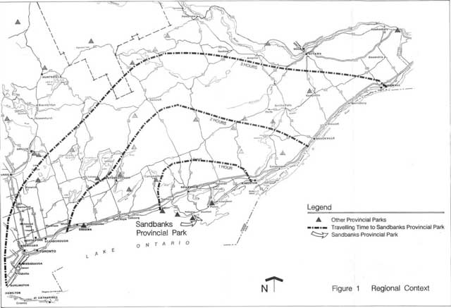
Sandbanks Provincial Park is located on Lake Ontario, within Athol and Hallowell townships in Prince Edward County (see Figure 1). The park occupies much of the southwestern shoreline of the county between the village of Wellington on the northwest and Salmon Point on the southeast. Sandbanks Provincial Park is composed of three distinct land areas: two large coastal baymouth dune formations, and an intervening area of scenic rural land on a limestone-based peninsula. These areas of the park will be referred to in this plan as the Dunes Sector, the Outlet Sector and the Woodlands Sector. The entire park is approximately 1600 ha in size and is one of the most popular and highly used parks in the Ontario provincial park system.
1.2 Park character and use
Sandbanks Provincial Park encompasses a diverse range of ecosystems of provincial significance. The West Lake baymouth dune is the largest in the world on freshwater. Vegetation features of the dunes and associated low pannes are well developed and are provincially significant. The park supports over 200 species of birds, including some rare species and is significant as a stopover point for migratory shorebirds. The land between the two baymouth dunes is composed of mature woodlots and agricultural fields, interspersed with hedgerow and old field habitats. This area of the park has a rich and varied past, containing several significant prehistoric and historic sites, buildings and landscapes.
Sandbanks Provincial Park’s popularity reflects its roles as a vacation destination for campers and as a day use area for local and regional residents. Sandbanks maintains campsite occupancy rates in the 90%-100% range for July and August, among the highest in the provincial parks system. In 1991, there was a total of 128,412 camper nights recorded, along with 222,959 day users.
Before 1979, Sandbanks existed as two separate provincial parks on each of the baymouth dunes. Outlet Beach Provincial Park included the dunes between Lake Ontario and East Lake and Sandbanks Provincial Park contained the dunes between Lake Ontario and West Lake. Outlet Beach Provincial Park was in operation from 1959, while Sandbanks Provincial Park was established as a Forestry Station in 1921 and became a provincial park in 1962. In 1971, a proposal to buy private land between the two parks was approved by the Ontario government and land acquisition has continued since that time.
1.3 Previous planning
A Master Plan (the term formerly used for management plans) approved for the park area in 1979 recommended that the two parks, along with the intervening Crown lands, be brought together into one administrative unit. Through an Order in Council dated March 1, 1984 and Ontario Regulation 152/84, the combined area was regulated under the Provincial Parks Act as Sandbanks Provincial Park.
Management plans are required for each provincial park. The 1979 master plan for Sandbanks Provincial Park is now twelve years old and Ministry of Natural Resources policy requires a public review. The evolving management plan has been reviewed with the public through public meetings, Dunes newsletters, a Preliminary Management Plan and discussions with elected representatives.
The approved Management Plan will provide a planning framework for the next twenty years, with a public review scheduled after ten years.
Chapter 2: Summary of significant issues
In the planning background information document for Sandbanks Provincial Park (1990), issues related to park planning were discussed. Of the issues outlined in that document, several have remained contentious, as evidenced by public response received as part of the planning process. These issues, and others arising during the preparation of this plan, are summarized below. Policies to address these issues are contained in the Management Plan.
2.1 Access to the park
Concerns about increasing tourist traffic in Prince Edward County and, in particular, traffic related to the park led to a 1988 transportation study. This study recommended, among other improvements, a single multi-lane entrance into the park. This entry would avoid long line ups on the county road outside the park, particularly on busy weekends. It would provide better control of the use of park lands and greater unity among the three sectors of the park. It would also lower the costs of operating three separate entrances to the park.
Local residents, particularly those who live or maintain seasonal dwellings within the boundaries of the park, have expressed concerns that a single entry point will make access to their dwellings less convenient than the present system. They also fear that it could lead to a loss of basic municipal services (e.g. mail, tire protection, school buses, garbage collection, etc.).
2.2 Internal road connections
The current public road system in the Woodlands Sector is largely under the ownership and maintenance of the county and townships and is outside the jurisdiction of the park. The recommendations of the 1979 Master Plan and the 1988 transportation study would have the affect of closing portions of the current county road system through the park. They would unify the park and provide more efficient internal transportation routes.
Local and county residents expressed concern about the possibility of the county roads through the park being brought under the park’s jurisdiction. There is considerable local opposition to any restrictions on access to the public scenic drive along Athol Bay on County Road 12.
2.3 Continued land acquisition
Since 1971, the Ministry of Natural Resources has been acquiring lands in the rural area between the baymouth dunes. Today, there are a number of private land holdings remaining in this area and some park lands are leased for agricultural use. Public questions have been raised about the ministry’s policies relating to continued acquisition and to the lack of park use of the lands that were acquired in the 1970s and 1980s. It is ministry policy to consider any lands in the Woodlands Sector for acquisition if they are willingly offered for sale by the owner.
2.4 Impact of recreation on park resources
The environmental affects of recreation are evident in several areas of Sandbanks Provincial Park. The dunes and pannes in the day use areas of the Outlet and Dunes sectors and the campgrounds in the Outlet Sector are of particular concern. Policies to address these problems are contained in this Management Plan.
For the first time in the park’s history, the beach at Sandbanks Provincial Park was declared unsafe for bathing by the local health unit due to high counts of fecal coliform bacteria. This beach posting, from August 10 to August 24, 1990, was of great concern to local residents and vacationers alike. In 1991, the beach was again posted for four to five days during August. The local conservation authority, through the Ministry of the Environment’s Rural Beaches Program, is investigating the source of the pollution. This issue is considered to be outside the mandate of the Management Plan.
2.5 Park landfill site
Solid waste generated from within the park is disposed of in a landfill site within the Woodlands Sector. The park landfill is licensed by the Ministry of the Environment and is reviewed annually by ministry inspectors. The landfill remains an issue locally. The ministry has recently begun a recycling program to reduce the amount of waste generated in the park.
2.6 Management of heritage resources
In 1972, the Ministry of Culture and Communications recommended approaches for preserving and interpreting cultural heritage in the park, in particular those resources in the lands now known as the Woodlands Sector. There have been concerns expressed that such cultural resources have been allowed to deteriorate over the past twenty years. Policies relating to cultural heritage preservation and interpretation are included in this Management Plan.
2.7 Access to Athol Bay
Public access to the Lake Ontario shoreline of Prince Edward County for launching or mooring small boats is limited. No such opportunities currently exist on Athol Bay. The public and elected representatives have encouraged the ministry to consider water access facilities on Athol Bay. Water access opportunities for small craft are addressed in this Management Plan.
2.8 Jet-ski and parasailing concessions
Motorized recreational uses such as jet-skis and parasailing are bath popular and contentious. Park staff have received requests for the provision of jet ski and parasailing concessions in the park. At the same time, many people feel that these recreational activities are disruptive and inappropriate uses within the park.
2.9 New campgrounds
There are currently few opportunities for recreational vehicle camping in the park. The demand for recreational vehicle camping in provincial parks is high. The Ministry of Natural Resources has also recently acquired two private campgrounds that catered to recreational vehicles. However, local private campground operators are concerned that provision of recreational vehicle camping opportunities in the park may constitute unfair competition for their businesses.
Chapter 3: Classification and goal
3.1 Classification
Sandbanks Provincial Park is classed as a Natural Environment Park, in recognition of its provincially significant baymouth dune formations and their vegetation, and its regionally significant life science and cultural resources. This classification also recognizes the superb recreational and educational opportunities offered in the park, its scenic setting and its popularity as a vacation destination.
3.2 Goal
The goal of Sandbanks Provincial Park is to protect and interpret its provincially significant freshwater baymouth dune formations and associated ecosystems and its significant cultural heritage resources, while offering a range of high quality, compatible recreational experiences.
Chapter 4: Park objectives
Sandbanks Provincial Park contributes to all four objectives of the Ontario Provincial Park system as follows.
4.1 Resource protection
To protect provincially significant elements of the natural and cultural landscape of Ontario.
Sandbanks Provincial Park is part of a physiographic area known as Site District 6-15, which is located on the northeastern shore of Lake Ontario between Brighton and Gananoque. The park contains many significant earth science, life science and cultural resources that are worthy of protection.
The West Lake baymouth dune complex is the largest of its kind in the world. These dunes remain a dynamic system, with sand movement and deposition forming an ever changing landscape of provincial, if not national, significance. The Outlet River baymouth dune system is smaller and is largely forested, resulting in a higher level of stability. The dune complexes are described in more detail in Section 6.2 and in the Background Information Document.
The vegetation communities of the dunes and their associated pannes (low, windscoured sand troughs between the dune ridges which are seasonally or permanently wet) are very well developed and are provincially significant. Vascular plants of the Great Lakes shores, Atlantic coastal, southern and temperate affinities are present and are locally abundant. Several species are of provincial or regional significance (e.g. Arrow Arum, Dwarf Mistletoe, Bluets, Hoary Puccoon and Stemless Blue Violet).
The park also includes mature climax woodlands in the Woodlands Sector. These climax forests are relatively rare within Site District 6-15 and are representative of the pre-settlement land cover in the area. They provide important habitat for a variety of faunal and avifaunal species.
Sandbanks Provincial Park contains good woodland bird breeding habitat and provides a significant stopover point for migratory shorebirds. The variety of habitats available, including old fields, plantations, marshes and wetlands, pannes and woodlots, create an environment highly conducive to a rich diversity of avifauna, including uncommon and regionally rare species (e.g. marsh wrens, swamp sparrows and white-rumped sandpiper).
There are two confirmed archaeological sites within Sandbanks Provincial Park. These assets provide evidence of the Princess Point culture of over 1000 years ago and of later occupations of fishing peoples, probably of Huron affiliation, dating back to 1400 A.D.—1500 A.D.
The Management Plan makes specific provisions for protecting, restoring and/or enhancing park resources. The significant dune and riparian systems are protected from incompatible and uncontrolled recreational use. Initiatives are also described for stabilizing degraded dunes and for expanding the forested area in the Woodlands Sector through managed natural succession.
4.2 Heritage appreciation
To provide opportunities for the exploration and appreciation of the outdoor natural and cultural heritage of Ontario.
Sandbanks Provincial Park protects unique dune ecosystems, which have natural and cultural heritage significance. Besides the features described under the protection objective above, the dunes also have a unique and fascinating cultural heritage story. The West Lake dunes were once stable, vegetated and considerably closer to the Lake Ontario shoreline than they are today. As agricultural uses spread in the late 1800s, the dunes became de-vegetated and unstable. Wind drove the exposed sand to the north and east, moving the main dune closer to West Lake, enlarging the panne area between the foredune and the backdunes. The movement also covered fields, houses, forests and roads in its relentless advance. Only through extensive reforestation over the past 70 years have the leading edges of the sand been stabilized.
Other themes of cultural heritage that are appreciation of Sandbanks Provincial Park’s unique cultural and natural heritage. Other themes of cultural heritage that are found within the park include the history of agricultural development and the gill-net currently provides 411 campsites, of which United Empire Loyalist settlement patterns. The former grand old Lakeshore Lodge (a century-old luxury resort of provincial fame) and the prehistoric native settlements related to the fishery on Lake Ontario are also important.
An expanded interpretive program, including trails, interpretive points, observation points, guided nature and cultural heritage walks, is proposed. Multimedia productions, along with a new visitor centre, are also proposed to give visitors an understanding and recommendations in this plan will enhance camping opportunities through the addition of new campgrounds catering to recreational vehicle camping.
4.3 Recreation
To provide outdoor recreation opportunities ranging from high intensity day use to low intensity wilderness experiences.
Sandbanks Provincial Park provides a range of high quality recreational experiences and remains one of the most popular provincial parks in Ontario. The park offers some of the best swimming beaches in Ontario and it is highly used as both a day use and a vacation destination. Sandbanks Provincial Park contributes significantly to the forecasted demand (recreation targets) for provincial park use in the Napanee District Land Use Guidelines, including 27% of the picnicking and 27% of swimming opportunities in that district. Sandbanks is also the only provincial park in Prince Edward County to provide camping.
In 1991, camper nights totalled 128,412 at supported the fourth highest camping use for the park. Statistics show that the park found within the park include the history of all Ontario provincial parks. The park fishery in Prince Edward County, and the 217 can accommodate only tents.
Sandbanks Provincial Park cannot satisfy the current demand for its campsites. The park’s campgrounds operate at 95% capacity during the peak months of July and August and there are large numbers of campers who line up daily for vacant sites. Only 40% of campsite reservation requests are presently accommodated. Day use at the park also exceeds capacity in the Outlet Sector on summer weekends with good weather. Current capacity for day use at the Outlet beach is set by a parking capacity of approximately 1,200 vehicles.
A survey of campers at the park showed that swimming, casual play, picnicking, trait hiking and viewing were the most popular activities. Campers demonstrate high attendance at park visitor service programs, including conducted hikes, children’s programs, displays, campfires and special interpretation events. In summary, Sandbanks Provincial Park provides an attractive place to camp for families seeking a good beach, an interesting area to explore and a variety of visitor service programs.
Day use of the park is also very popular with both local residents and tourists who stay at nearby accommodation outside the park. On average, day users make up about 65% of the users of the park, which reflects approximately 47,916 day use permits being sold in 1990. While day use is highly dependent on weather, statistics show a steady increase in day use at Sandbanks over the past ten years. Studies show that the high quality beaches at Sandbanks are the most popular park features for day users, along with opportunities for picnicking, hiking and nature photography.
The Management Plan enhances the recreational experiences available in the park. New recreational initiatives include the reorganization of parking and beach access in the Outlet Sector, and the provision of new hiking and cycling trails along Athol Bay and through the Woodlands Sector. New campgrounds and a new day use area in the Woodlands Sector are also proposed.
4.4 Tourism
To provide Ontario residents and visitors from outside the province with opportunities to discover and experience the distinctive regions of the province.
Sandbanks Provincial Park is one of the most popular provincial parks in Ontario. In 1991, a total of 351,371 visitors to the park was recorded. Studies show that for the great majority of these visitors, the park was the primary destination of their trip to Prince Edward County. The park is a significant contributor to the economy of its local area. In 1988-1989, direct park expenditures for programs and operations totalled $670,745 while direct visitor expenditures within 40 km of the park amounted to $5,724,270.
The park and the area around it provide many high quality tourism opportunities, including camping, swimming, beach play, fishing, boating, picnicking, nature and heritage viewing and photography, board-sailing and occasional cross-country skiing in winter.
The Management Plan proposes new tourism opportunities including a new visitor centre, roofed accommodations and new campgrounds catering to recreational vehicles.
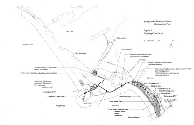
Chapter 5: Park boundary and zoning
The current park boundaries are shown in Figure 2. As stated in the Introduction, the boundaries of the park have changed considerably over the past twenty years. A land acquisition program in the Woodlands Sector has resulted in a contiguous land base, bisected in several areas by County Road 12 and County Road 18. Within the land base of the park, there remain several private land holdings and permanent homes. These private lands within the boundary of the park will be considered for acquisition as they are willingly offered for sale by the owners.
The long range goal of the land acquisition program remains to assemble all the lands within the current boundaries of the park.
Currently, the park is approximately 1600 ha in size, including Lake Ontario waters within 400 m of park shores and West Lake and East Lake waters within 100 m of park shorelines.
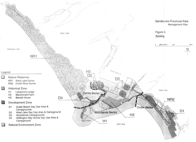
Within Sandbanks Provincial Park, five types of zones have been designated to guide the management of the park. These zones are shown in Figure 3 and summarized as follows.
5.1 Nature reserve zones
5.1.1 Nature reserve 1: West Lake dunes (545 ha)
The Dunes Sector of Sandbanks contains the largest freshwater baymouth dune formation in the world. These dunes, together with their associated pannes and beaches are incorporated into the first Nature Reserve Zone.
The West Lake dune system stretches for eight kilometres along Wellington Bay, separating Lake Ontario from West Lake. The highest sand dunes are next to West Lake and reach up to eighteen metres. These dunes are migrating in a northeasterly direction, progressively pushing into West Lake.
The Lake Ontario beaches are backed by a low foredune system. Between these two ridges of dunes is a large area of pannes and low dunes. The pannes are low-lying sand fiats that are characterized by a fluctuating water table resulting in extremes of drought and periodic inundation. Within this zone are unique evidences of the movement of sand over time, including exposed soils which were once buried by sand and remnants of former dunes.
The movement of the dunes accelerated during the late 19th century and into the 1950s, as the previously stable, vegetated dunes became destabilized through land clearing, logging and overgrazing. The high dunes continue to migrate, as the devegetated dunes are driven by winds.
The sensitivity of the dune systems is increased because there is very little supply of sand for the dunes from Lake Ontario. The beach along Wellington Bay is now largely pebbles and very little sand is introduced into Wellington Bay by littoral drift, erosion, or fluvial deposition. Sands are reworked local materials which are of glacial origin.
The extreme sensitivity of the dunes and pannes to human use and their status as a resource of provincial earth science, life science and archaeological significance fends support to the Nature Reserve Zone designation.
Management of the dune systems will be based on allowing the natural processes of dune movement and vegetative succession to continue without human intervention and impact. Access to the West Lake dunes will be provided by a self-guided interpretive trail system. This system will be located through carefully selected areas of the dunes, pannes and beaches in the Nature Reserve Zone (see Sections 7.2 and 8.7). The trail system is intended to satisfy the public demand for access into the dunes, while allowing control of recreational use and protection of the dunes and pannes from the impacts of random trampling.
Trail use and impacts will be monitored by park staff, so that any adverse conditions can be addressed through the access restrictions available for Nature Reserve Zones within the provincial park system. Special permits will be required for scientific research. Motorized access of all kinds will be prohibited on the dunes, except in emergencies.
5.1.2 Nature reserve 2: Outlet River dunes (18 ha)
One area of the Outlet River dunes that has not been developed for camping, or severely affected by trampling, is included in the second Nature Reserve Zone (see Figure 3). It is a bench mark against which changes to the back dunes of the East Lake barrier can be monitored. These dunes differ from the West Lake dunes in morphology, vegetation and surrounding land use. They are lower and are forested.
Current park development within this zone is limited to the Cedar Sands Trail, a self-guided interpretive trail that is also used by groups led by park naturalists.
Management policies for this zone will concentrate on controlling human use and on allowing natural processes to operate without human intervention. Human use in the Nature Reserve Zone will be restricted to the existing Cedar Sands Trail. The shoreline of the Outlet River within this zone will be protected through restricted boating access. Also, the enforcement of a no-wake policy and speed limits for motorized boat traffic is proposed on the river (see Section 7.2).
5.2 Historical zones
5.2.1 Historical zone 1: Lakeshore Lodge (10 ha)
The area around the former Lakeshore Lodge is rich in prehistory and recorded historical resources.
The archaeological record on the site includes evidence of a large, multi-component woodland fishing station that was intermittently used between 600 A.D.—1500 A.D. This site has a high potential for further archaeological discovery.
This site continued to be a popular destination point in more recent times. In 1879, the Lakeshore Lodge was developed as a major recreational hotel. Over the years, the hotel was redeveloped and expanded. By the turn of the century, Lakeshore Lodge was one of the premier the holiday destination resorts in Ontario.
The hotel was strategically sited on the shore of Wellington Bay on limestone ledges, near the point where the high sand dunes began. The site included a dance pavilion, a recreational hall, swimming pool, a large dock and a row of cottages connected to the lodge by a boardwalk.
The lodge declined in popularity after its turn of the century peak. It closed in 1973. The Ministry of Natural Resources had acquired the property in 1972. In 1983, white redevelopment of the lodge was being considered, the building burned down. The site now reveals only the foundation ruins of the lodge and the dance pavilion, as well as its stone entry gates. The site continues to be a popular picnicking and exploration area and quiet enjoyment area for local residents and visitors alike.
Management policies for this zone include the protection of known and potential archaeological sites from development and the maintenance of the existing ruins. They also cover the maintenance of the natural shoreline, historic vegetation and the views over Wellington Bay and along the sand dunes.
New developments will be designed to preserve historic traces and landscapes in the zone. The proposed visitor centre will be designed in keeping with the architectural character of the former lodge and its outbuildings. The area around the lodge site and the shoreline will be pedestrian access only. Parking areas will be designated just outside the old stone gates to maintain the quiet atmosphere of the site.
Appropriate interpretation of the lodge and the nearby archaeological sites will take place. Archaeological research by licensed individuals will be allowed under permit.
5.2.2 Historical zone 2: MacDonald Farm (56 ha)
The cultural heritage resources within this zone include the MacDonald farm, the remnants of the Lakeland Lodge, the historic MacDonald / Hyatt wharf and areas of archaeological potential. The Gray House operated as the Lakeview Lodge soon after its construction in 1869 by the Hyatt family. The MacDonald Farm offers insights into historical agricultural uses of park lands. It dates back to the time of United Empire Loyalist settlement and illustrates the historical themes of agriculture and resort development unique to this area of the province.
The potential for restoration or adaptive reuse of the structures will be examined and considered through appropriate technical cultural heritage studies. In keeping with the intent of adaptive reuse of the properties, the development of other facilities (e.g. roofed accommodation) may be considered in the location of the historical buildings.
This Historical Zone also includes several of the agricultural fields associated with the MacDonald Farm and the historic Gray House. The agricultural fields contained in the Historical Zone will be managed to retain the spatial form of the field and hedgerow patterns of the late 1800s period, as determined by studies such as technical cultural heritage studies, and as detailed in the vegetation management plan.
5.2.3 Historical zone 3: Barrett House (3 ha)
A third Historical Zone includes the late Victorian Barrett House and its immediate grounds. This house was restored in 1999 in partnership with the Friends of Sandbanks and is in good condition. It is used as roofed accommodation for visitors to the park.
5.3 Development zones
The Development Zone applies to all areas of the park that have existing recreational facilities, with the exception of the Historical Zones and to areas that are proposed for additional recreational facilities. The specific Development Zones are shown in Figure 3 and are summarized as follows.
5.3.1 Development zone 1: Park entrance, outlet beach day use and campgrounds (98 ha)
This zone applies to the new park entrance and access roads, the three existing campgrounds in the forested backdunes of the Outlet Sector, along with the day use beach and parking areas in the Outlet Sector. The riparian area along the Outlet River and the foredune immediately behind the Outlet Beach are not included in this zone. They are covered by the Natural Environment Zone.
5.3.2 Development zone 2: West Lake day use area (22 ha)
This zone includes the proposed new day use and swimming beach development at West Lake and the adjacent proposed recreational vehicle campground. A trail leads from this zone to the Natural Environment Zone in the reforested dunes, the site of the proposed dune observation tower.
5.3.3 Development zone 3: Woodlands campgrounds (24 ha)
This development zone includes the proposed new recreational vehicle campsites, in the area of the mature maple woodlots in the Woodlands Sector.
5.3.4 Development zone 4: Wellington Bay day use and campground (20 ha)
This development zone includes the existing campground, the access road to Wellington Bay Day Use Area and the existing parking area and day use beach.
5.4 Natural environment zone (804 ha)
The remainder of the park lands are included in a single Natural Environment zone. This zone includes scenic landscapes such as the field and forest environments of the Woodlands Sector, the shorelines of the Woodlands Sector along Athol Bay and West Point, the forest plantation areas of the Dunes Sector and several areas within the Outlet Sector. It also includes the beach, foredunes, wetlands and riparian areas along the Outlet River.
Management practices in this zone will be directed towards maintaining natural processes, with some provision for the managed natural regeneration of woodland and old field habitats. They will also allow for low-intensity recreational uses such as hiking, cycling and nature interpretation.
Chapter 6: Resource management policies
The natural and cultural resources of Sandbanks Provincial Park will be managed according to the general planning and management policies for Ontario’s natural environment class parks.
More detailed resource management plans will be required to recommend specific management techniques and strategies for three of the special resources of the park. These involve dune management, vegetation management and cultural resource management.
6.1 Aquatic resources
6.1.1 Water quality
Water quality in the major bodies of water that lie only partly within the park: Lake Ontario, West Lake, East Lake and the Outlet River, is largely beyond the control of management initiatives within the park boundaries. Water quality in the park will continue to be monitored on a regular basis.
Both East Lake and West Lake are moderately eutrophic, with nutrient loading occurring as a result of run-off from agricultural land and adjacent residential development, and as a result of restricted outflows into Lake Ontario. Management of these waters within Sandbanks Provincial Park will concentrate on maintaining or enhancing wetland and shoreline vegetation. Objectives will include reducing nutrient enriched run-off, and prohibiting recreational uses that contribute to pollution in the lakes.
Algal blooms occur periodically in Lake Ontario due to weather and nutrient conditions. Onshore winds create accumulations of algae and sometimes dead fish on the beaches in the park. In development zones (i.e. Outlet Beach), the policy will continue to be the raking and removal of these accumulations during the summer park season.
High counts of fecal coliform bacteria in the summer of 1990 resulted in the closure of the Lake Ontario beaches in the park to swimming for a fourteen day period. In 1991, the beach was also posted for four to five days in August. The Ministry of the Environment is currently investigating the source of the contamination and corrective actions that may be taken.
Water quality in the Outlet River is affected by the water quality in East Lake, as well as by recreational boating and shoreline uses within and outside the park. The Prince Edward Region Conservation Authority will continue to control the outflow of the river into Lake Ontario, by monitoring East Lake water levels. Water quality in the portion of the river within the park will be maintained or improved through the protection of shoreline wetland and riparian vegetation. Prohibiting recreational uses that degrade water quality and removing campsites and other uses along the shores that cause increased erosion, siltation and turbidity will also be important tactics.
6.1.2 Fisheries
The waters in and around Sandbanks Provincial Park support a thriving commercial and sport fishery. The number of hours of fishing effort in the sport fishery has increased dramatically in recent years, as the Lake Ontario trout and salmon fisheries have been rehabilitated through stocking efforts and improved water quality. The sport and commercial fisheries in the park will continue to be regulated and monitored through the fishery regulations of the Ministry of Natural Resources.
The commercial harvests from waters around Sandbanks Provincial Park contribute to the local economy through direct employment and secondary processing. Fish from this area are generally sold to two fish buying and processing facilities in Prince Edward County or to a fish buyer at Brighton.
6.2 Earth science resources
6.2.1 Dune ecosystems
A dune management plan will be required to recommend specific strategies and techniques for the stabilization, revegetation and management of the provincially significant dune systems in Sandbanks Provincial Park. As the dunes are varied in their character, morphology and ecology, appropriate techniques will need to be developed for different dunes. The following general policies will guide the development of the dune management plan.
All dunes in Nature Reserve zones will be allowed to evolve naturally. Human presence on these dunes will be limited to a defined trail system, with the exception of approved scientific research or emergency response.
Dunes that have been stabilized through plantation techniques will be allowed to evolve naturally. Intervention will be limited to the placement of interpretive trails and boardwalks in appropriate locations as determined through on-site investigations.
Dunes that have been degraded through human use will be the focus of dune rehabilitation efforts with the goal of stabilizing and naturalizing the dunes. These techniques may include the planting of appropriate native plant species, control of human traffic through fencing and other means to protect the dunes. The removal of campsites and other causes of dune degradation and methods of accommodating pedestrian traffic over the dunes while minimizing impact, may also be addressed. Dunes that encroach on parking areas and recreational facilities will be given the highest priority in rehabilitation and stabilization efforts.
6.2.2 Pannes
The large natural pannes in the Dunes Sector will be allowed to evolve naturally and will be protected from human impact. The panne area near the West Lake Day Use area is of artificial origin, resulting from the extraction of sand in the mid 1900s. This panne will be managed to allow natural processes to evolve, while allowing natural heritage interpretation for visitors, with a boardwalk system and interpretive nodes.
The remnant panne areas in the Outlet Sector are covered by parking areas and roads. These areas will not be managed as a natural panne, but, if areas of panne result through natural aeolian processes following the reorganization of parking areas at Outlet Beach, they will be protected from human impacts.
6.2.3 Shorelines
Lake and river shorelines will be allowed to evolve naturally, with the exception of day use beaches in development zones and where park or municipal property is threatened by erosion or high water damage.
Unstable shorelines, in particular those along Athol Bay in the West Point area, will be managed to allow natural regeneration and selective managed succession of native plant communities, subject to the recommendations of the vegetation management plan. The Prince Edward Region Conservation Authority will continue to monitor water levels in East Lake and control the outflow of the Outlet River mouth.
6.2.4 Beaches
Day use and swimming beaches in development zones will continue to be managed to ensure a high quality recreation experience. The beaches in the park will be graded and raked as required during the summer months to remove debris and garbage from the beach. Algal deposits along the water’s edge will also be removed during the summer park season. Because the removal process captures sand, such materials can be used as fill during park facility development. The appropriate use and stockpiling of this material will be detailed in the Park Operating Plan. The continued use of snow fencing or other means of trapping sand blowing inland on the beaches during the winter will be subject to recommendations in the dune management plan. The goal will be to eventually eliminate this intervention into natural dune formation processes.
6.3 Vegetation resources
The overall goal of vegetation management in Sandbanks Provincial Park is to ensure the richest possible variety of naturally occurring plant species and communities inherent to the park’s unique microclimate and topography.
A vegetation management plan will be prepared to guide the specific management policies and initiatives that will contribute to this goal. The emphasis will be on allowing the flora of Sandbanks to evolve naturally over time.
6.3.1 Principles of vegetation management
The vegetation resources of the park will be managed to:
- ensure native species diversity and age diversity;
- allow the natural succession and evolution of the various vegetation communities in the park;
- protect rare or endangered plant species and communities;
- ensure the safety of park visitors, especially in highly used areas;
- enhance wildlife habitat through natural and managed reforestation in the Woodlands Sector.
Only species native to the Sandbanks area will be planted, with the exception of species associated with historic zones or traditional land uses. Planting will be focused in development and access zones, where natural regeneration is too slow or uncertain to create buffers and effective control of erosion sites. A native plant nursery will be maintained, with stock originating from within Sandbanks to maintain local genetic strains. The vegetation management plan will provide guidelines for plantings in all zones.
6.3.2 Vegetation management issues
Special issues of vegetation management that will be detailed in the vegetation management plan include:
- rare species and communities to be protected from human activities and impacts that threaten their survival and perpetuation;
- dune stabilization plantings to be a priority in areas of degradation, using native species such as dune grasses propagated at a nursery within Sandbanks Provincial Park from local genetic strains;
- woodlots, such as those found in the Woodlands Sector, to be allowed to evolve naturally, with the goal of attaining a climax hardwood forest with species and age diversity. Low-density campground development will be permitted within woodlots, but only on a selected basis, subject to field evaluation and on-site design. Vegetation changes due to human impacts on the edge of the woodlots will be monitored and preventative action taken as required;
- plantations of largely exotic pine species used to stabilize the dune system in the West Point area during the 1920s to 1950s period have since formed dense pine forests. These plantation areas will be left to evolve naturally. However, the vegetation management plan may identify areas within the plantations where trees need to be removed to enhance the regeneration of particular habitats or plant communities. If vegetation monitoring identifies an invasion of plantation species into other areas of the park, the invading plants will be removed using mechanical rather than chemical means. Prescribed burning to manage the pine plantations may also be carried out if appropriate;
- a program of reforestation and naturalization in the Woodlands Sector to be detailed in the vegetation management plan. Reforestation will be based largely on natural succession, with some managed succession and limited planting in select areas. The existing mature woodlots will form the core of the natural regeneration area. Agricultural practices will be curtailed in the areas designated for regeneration. The reforestation program will seek to form the largest possible blocks of contiguous woodland corridors within the Woodlands Sector, given existing and proposed development locations;
- the vegetation management plan will include areas that may be managed and maintained as old field and hedgerow habitats, or to provide other specific habitat requirements for native species, as deemed desirable;
- areas associated with historical zones and landscapes may include non-native, non-invasive species that are known to have been planted on the site in the past. Vegetation with cultural heritage value (e.g. hedgerow patterns, historical crops, heritage landscapes) may be maintained and managed according to recommendations of the cultural resource management plan for the park;
- vegetation in campgrounds and along areas within the plantations where trees maximize buffers between campsites vegetation management plan may identify roads and trails will be managed to need to be removed to enhance the while ensuring public safety. Hazardous trees within 25 m of the edge of roads or parking areas may be felled and salvaged. Hazardous trees that threaten the safety of trail users and campers may be felled and salvaged, if they can be removed without environmental damage. Such salvage will not be permitted in Natural Environment Zones, however;
- noxious weeds and invasive plants, such as Poison lvy, may be controlled as required in development zones or along trails in other zones for public protection. Species not native to Sandbanks may be controlled or eliminated where feasible, by the most environmentally sound method available. Purple Loosestrife will be monitored and, if deemed to be a threat to the panne vegetation, may be controlled;
- the use of chemicals in the control of pests and weed species will be minimized, with biological or mechanical methods used wherever feasible. Directions for the use of chemicals will be provided in the vegetation management plan;
- insects and disease that attack the vegetation of the park will be considered as a natural process and will not be controlled, except in the following instances:
- where they threaten the values for which the zone has been established;
- where the public well-being is threatened;
- where heritage structures or vegetation is threatened
Where control of pests is desirable, it will be directed narrowly to a specific insect to have minimal impacts on the natural ecosystems of the park. Biological control, rather than chemical control will be used wherever feasible.
6.4 Wildlife resources
The main objective of wildlife management in the park will be to enhance the natural species diversity in Sandbanks Provincial Park while providing for recreational activities that are compatible with the park’s natural environment classification. Wildlife resources within the park will be managed through the preservation and restoration of naturally occurring ecosystems. The vegetation resources management plan will guide the management of wildlife habitat in the park.
Enhancement of wildlife habitat will occur mainly through the proposed program of natural regeneration and reforestation in the Woodlands Sector. A continuous corridor of woodland and old field habitats will be established between the Outlet River dunes and the West Lake dunes. As well, the establishment of a woodland corridor that would link woodlands within the park with woodlots on private lands outside the park will be pursued. This may require some park boundary adjustment and/or landowner agreements developed with the full cooperation and advice of landowners.
Besides the regeneration corridor, special habitat needs will be preserved through protection of existing habitats and the managed evolution of new habitats. For example, the open old fields near West Point have been identified as a potential habitat for the provincially threatened Henslow Sparrow. If further investigations warrant, this area may be managed to perpetuate old field habitat.
Hunting and trapping will not be permitted within the park. Trapping for management purposes may occur for the control of any species or individual animal that threatens public safety, park facilities, or park values.
Wildlife studies will be undertaken to determine habitats, species composition, populations and distribution of wildlife in the park. This data is currently lacking for mammals, reptiles and amphibians, and is important for establishing baseline information to allow monitoring of changes over time as the regeneration corridor evolves.
6.5 Cultural resources
A cultural resources study was completed in 1991 which identified the cultural heritage resources of Sandbanks Provincial Park, outlined their significance and made recommendations for their management. Heritage attributes in the park include:
- the Lakeshore Lodge ruins and the associated landscape;
- the MacDonald Farm and the associated wharf site and agricultural field patterns;
- the site of the Gray House (Lakeview Lodge);
- the Barrett House;
- the sugar bush at the intersection of Maple Lane and the West Point Road.
Restoration of the Barrett House took place in 1998/1999 in conjunction with adaptive reuse of the structure (see Section 7.4.3). As resources permit, other remaining significant structures will be mothballed and not be allowed to deteriorate further. Opportunities for interpretation of cultural heritage resources will be explored. Interpretation approaches will be developed as needed and may be supported by future studies or research.
A 2015 Stage 1 archaeological assessment for the park indicates that some portions of the park are considered high potential for pre-contact and post-contact cultural heritage resources. Archaeological sites that have been identified in the park, as well as sites that are discovered, will be protected from development.
Cultural heritage resources that may be impacted by park projects and activities shall be identified and managed (i.e. protected, maintained, used and disposed of) in accordance with guidelines regarding cultural heritage resources and technical cultural heritage studies.
Chapter 7: Operations policies
A Park Operating Plan will be prepared to provide park staff with the necessary information required to operate the park on a daily basis. Along with addressing the operations policies that follow, the strategy will include such topics as budget, staffing, maintenance schedules, enforcement and emergency response services. The provisions of the strategy will be consistent with the approved Ontario Provincial Parks Operating Standards and will be reviewed annually and updated as required.
Park facilities will be operated in accordance with the park operating plan, subject to availability of operating funds. If operating funds are reduced, facilities may be closed or operations curtailed in a manner that will minimize reduction of service to the public, while ensuring that park resources are protected.
7.1 Visitor services
The visitor services program at Sandbanks will provide visitors with the opportunity to gain an understanding, awareness and appreciation for the natural and cultural resources of the park. Sandbanks will provide visitor services according to the major activity level of programming as set out in policy PM 6.02.
A new visitor centre will be developed as the focus of the visitor services programs, including nature interpretation, recreation programs and information facilities (see Section 7.8). In the interim, before a new facility is built near West Point, visitor services will continue to be centred on the current park museum and visitor centre in the Outlet Sector of the park.
Visitor services will be guided by a visitor services management plan, which will be revised annually and will establish goals and objectives for the development and delivery of visitor information, interpretation and recreation programs. The plan will be prepared in concert with the newly forming Friends of Sandbanks. This organization will have an increasingly important role in park interpretation and visitor services.
7.1.1 Information
Printed and visual material will be prepared to encourage visitors to fully experience the park’s natural and cultural landscapes and passive and active recreation opportunities.
Information concerning the park’s resources, management, facilities, trail systems and special programs, as well as points of interest outside the park, will be available at key points throughout the park. Information will be provided by a park leaflet, the annual park tabloid, signs and special publications as required.
7.1.2 Interpretation
Interpretive programs will provide visitors with opportunities to learn more about the park’s resources and to experience its character and special areas. Current interpretive programs will be reviewed on an annual basis and amended as required. New interpretive programs will seek to educate both overnight visitors and day users about the special resources of the park, their dynamic nature and their response to recreational activities.
Specific interpretation themes will be determined in the visitor services management plan. The proposed visitor centre in the West Point area will become the centre for interpretation programs. In the interim, the existing visitor centre and park museum will continue to fill this function.
7.1.3 Recreation
Recreation programming will be limited. Opportunities for developing skills will be considered as part of the visitor services management plan. Outdoor activities could include canoeing on West Lake, low-impact camping and participation in human heritage activities. Criteria for selecting recreation programs will be based on their potential to encourage the appreciation and protection of the park’s natural and cultural resources.
7.2 Recreation management
Sandbanks Provincial Park is highly used for recreation and it also contains natural environments that are sensitive to human use. To ensure the protection of sensitive natural and cultural resources from overuse and degradation, controls must be placed on inappropriate recreational uses.
Jet-skis and parasails will be prohibited within park waters, including the Outlet River below the County Road 18 bridge. Motorboats will be allowed to operate on the Outlet River, but with restrictions on speed in combination with a no-wake policy.
To allow for the natural interest of visitors in the spectacular but fragile open sand dunes in the Dunes Sector, a system of carefully planned and located trails is proposed. Monitoring of trail use and impacts will be an important management activity. Any unacceptable impacts will require additional appropriate measures to be taken.
To allow observation of the dunes from a suitably dramatic perspective, a high dune observation tower near the West Lake Day Use Area and a separate viewing platform near the Lakeshore Lodge site are proposed (see Sections 7.5.3 and 7.5.4). Visitors will be allowed to access these points along trails and boardwalks, but will be discouraged from leaving the trails. The West Lake Dunes loop trail will provide more extensive (and less intensive) pedestrian access into the dunes but users will be advised against leaving the trails and walking on the dunes or pannes.
Park staff will follow the same access practices as park users, except for emergency response and exceptional maintenance and operational needs.
7.3 Research
Scientific research by qualified groups and individuals within the park will be encouraged to gain a greater understanding of the natural and cultural values and resource of the park. Research that may be used to enhance the operations of the park and the delivery of visitor services will also be encouraged. All research will require the approval of the Ministry of Natural Resources.
Subjects of research interest include, but are not limited to:
- geomorphic analysis of dune ecosystems and their development at Sandbanks;
- quantitative inventories of the fauna and flora of Sandbanks Provincial Park;
- analysis of the most appropriate means for transporting people across sand dunes with minimal damage;
- investigation, analysis and interpretation of archaeological resources;
- surveys of visitor perceptions and expectations, relating to parks operations and visitor services;
- baseline data and the environmental impacts of campgrounds and other park developments on natural ecosystems;
- monitoring of exotic species within the park, e.g. Purple Loosestrife, Scots Pine.
7.4 Marketing
Marketing of the park will emphasize the range and quality of recreational experiences available in Sandbanks Provincial Park.
Emphasis will be placed on the natural and cultural heritage of the park and on visitor service programs relating to natural and cultural heritage education and interpretation. Marketing efforts will attempt to attract visitors during low-use periods in the park, especially during the spring and fall seasons.
The newly forming Friends of Sandbanks organization will be consulted in developing marketing strategies. Marketing will need to continue coordination of efforts with tourism opportunities throughout Prince Edward County and opportunities for joint marketing initiatives between the park and the local municipalities.
7.4.1 Concessions
The concession at Outlet Beach will continue to operate under license from the Ministry of Natural Resources. A second concession at the West Lake Day Use Area will be permitted, if suitable private operators can be found and demand for this service is demonstrated.
The board-sailing concession at Outlet Beach will also continue to operate. Concessions for jet-skis and for parasailing will not be granted in the park. The feasibility of a canoe rental concession at the West Lake Day Use Area will be determined. If feasible, it will be provided.
7.4.2 Resort development
Commercial resort development will not be considered or permitted in Sandbanks Provincial Park.
7.4.3 Roofed accommodation
Two roofed accommodation facilities are available at Sandbanks Provincial Park: Maple Rest (Barrett House) and Jacques’ Cottage. Both facilities offer fully equipped kitchens, multiple bedrooms and excellent access to the park.
Roofed accommodation could also be developed on the site of the MacDonald House or Gray House.
7.5 Waste management
Sandbanks Provincial Park operates a sanitary landfill site within the park. This situation is not appropriate within a scenic, highly used Natural Environment class park. The sanitary landfill site will be phased out and rehabilitated and alternative solutions to the disposal of the park’s solid waste will be sought.
To reduce the amount of solid waste being generated in the park, the recycling program will continue and a composting program will be pursued.
Sewage will continue to be pumped from septic tanks and vault toilets by a local private operator. The proposed recreational vehicle campgrounds will require sewage pumpouts within the campgrounds, along with the existing pumpout near the exit of the Outlet Sector campgrounds. The storage, pumpout and disposal of sewage are regulated by the Ministry of the Environment.
7.6 Existing residential and private lands
Access to private residential properties within the park boundaries will be maintained. Section 7.2 describes the access and circulation provisions for residents and visitors alike.
Provision and delivery of municipal services to private homes will be maintained. Free access for residents and their guests to private properties within the park boundaries will be maintained throughout the year.
Chapter 8: Development policies
Park facilities will be maintained or replaced as necessary, as budgets allow, to provide continued service to park visitors and to ensure that public safety and environmental protection needs are met. Any structures posing a health and safety risk will be removed, subject to pertinent legislation and guidelines. New development is planned as follows.
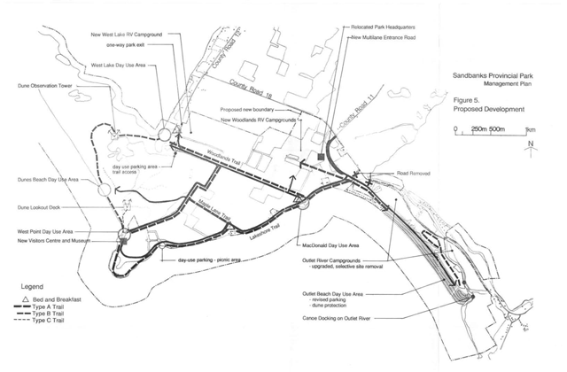
8.1 Access and control
A new access road and entry point are proposed, as shown in Figure 5. This access road will be the single entry and the main exit point for the park during the park operating season. A secondary exit-only point, with an automated gate, will be provided at the former Barrett property. This outlet will reduce internal traffic within the Woodlands Sector by those wishing to leave the park.
The entrance road will enter the park at the intersection of county roads 11 and 18 and will be controlled by a traffic signal during periods of high use.
Multiple entry lanes will reduce traffic backups and will allow the separation of day use, camper and local residential traffic. Changeable message boards over each lane will be considered to allow flexible and efficient processing of visitors. A separate exit lane will also be provided.
Associated with the proposed entry road will be a multiple booth gatehouse, a parking area for use during the daily roll-call for overflow campsites and a turnaround lane for visitors who are turned away.
8.2 Internal roads
A scenic drive is proposed for Sandbanks Provincial Park. The drive will follow the present Lakeshore Road and be two-way. It will be extended to follow the shoreline toward West Point and past (but not through) the site of the former Lakeshore Lodge to the existing township road and the West Lake Day Use Area. This extension will allow Maple Lane to be closed to vehicular traffic and converted to trail use.
The scenic drive will avoid West Point itself to allow a natural woodland to develop on the point that would be served by a short interpretive nature trail. The grounds of the former Lakeshore Lodge will be served by a small, peaceful picnic area and an interpretive centre that would provide visitors with opportunities to learn about the naturel and cultural history of Sandbanks Provincial Park.
Pull-offs, small picnic sites and access to interpretive nature trails will be provided at scenic locations along the parkway. Access to the parkway and the roadside sites will be free. For more extended use, such as camping and swimming at Outlet Beach, the Sandbanks Beach and the West Lake Day Use Area, permits will be required.
An extension of the road southeasterly from the West Lake Day Use Area (the former Barrett property) towards the MacDonald Day Use Area is proposed to provide a return link for scenic drive users and for travel between the Outlet and Dunes sectors of the park. Such a link will avoid the necessity of exiting the park or turning around within the West Lake Day Use Area.
Provision for bicycle and pedestrian use of these road corridors will be a factor in designing their alignment and construction. Maple Lane will become a heritage trail for use by cyclists and pedestrians.
8.2.1 Park entrance
A single entry to the park is proposed with special provisions for private property owners and service vehicles to bypass the entry area during busy periods. Visitors will be able to exit from the park by way of the new main entry road and at the West Lake portion of County Road 18 near the former Barrett property.
The single entry provides much greater storage capacity for arriving park visitors and reduces the conflicts posed by the present entrance at the Outlet Sector.
New access roads will be required to service the proposed recreational vehicle campgrounds in the Woodlands Sector, as described in Section 7.4. These are intended to be short connectors. A gate entrance, for staff access only, will also be provided at the Outlet Sector off Road 18 near the present exit.
8.3 Parking areas
Existing parking areas in the outlet sector will be redesigned and reorganized to reduce the environmental impact on the dune systems. The revisions will improve the efficiency of the traffic movement system during peak use periods and pedestrian safety in the day use areas. The redesign will also enhance the aesthetics of the recreational experience at Outlet Beach. A more detailed description of the proposed redesign of parking areas is included under Section 8.5.1.
Parking areas will be designed for the proposed new visitor centre and at the West Lake Day Use Area. The parking area at West Point will accommodate users of the visitor centre and the Lakeshore Trail and picnic areas. A separate, smaller parking area at West Lake will accommodate users of the interpretive trails that begin at West Lake.
Small parking areas will be provided at the MacDonald Farm and at the Gray House to accommodate those using the trail systems and the small day use/interpretive sites at the MacDonald Farm.
A parking area will also be provided at the main gatehouse and park administration headquarters, to accommodate those people who attend the daily roll-call for vacant campsite reservations or who seek information at the park headquarters.
8.4 Campgrounds
This management plan proposes a program of new campground development in the Woodlands Sector, in conjunction with a reduction of campsites in the Outlet Sector. The total number of campsites in Sandbanks Provincial Park will be increased from the current 411 sites to approximately 600 sites.
8.4.1 Outlet sector campgrounds
The existing campgrounds in the Outlet Sector will remain, with several campsites being eliminated where damage to the natural environment is evident or where substandard recreational experiences result from the proximity of campsites to County Road 18. The total reduction of campsites in this sector will be approximately 25 sites, bringing the number of campsites in the sector to 336, all of which will be restricted to tent camping, tent trailers and small (<9 m [30 ft]) recreational vehicles. The elimination of specific campsites in the Outlet Sector will be subject to recommendations in the dune management plan.
8.4.2 Woodlands sector campgrounds
The current Campground ’D’ in the Woodlands Sector will be retained as a tent, tent trailer and small (<9 m [30 ft]) recreational vehicle campground. A program of upgrading, including the planting of vegetation buffers and the relocation of campsites, will be initiated for this campground. A site plan for this campground will be prepared before its upgrading, showing specific road and campsite changes, selected tree removal if required, and new buffer plantings. The current number of sites in this campground will remain unchanged at approximately 50 sites.
Two new campgrounds will be developed in the Woodlands Sector for recreational vehicles (>9 m (30 ft). A site plan for both these campgrounds will be prepared, in conjunction with a comprehensive vegetation management plan. The objectives will be to ensure protection of significant vegetative communities and to guide revegetation and naturalization efforts in the campgrounds. The site plan will be based upon field design and surveys, involving careful siting of access roads, washrooms, individual campsites and related common areas and trails.
Similarly, construction will require close supervision based upon clear contract documents. The use of non-contracted work, through trained ministry staff, will be encouraged for those elements of construction (e.g. site clearing, campsite development, trails, etc.) that are difficult to specify adequately in contracts.
Both new campground locations have been selected to provide convenient access to day use facilities. This factor will be important in reducing unnecessary vehicular traffic between park facilities. The two locations also provide a choice of environments for camping; one largely treed and shaded, the other more open.
The larger of the proposed campgrounds is associated with mature maple woodlots and will be laid out with extreme sensitivity to the natural environment. A low density of sites will be achieved, to maintain a high quality of recreational experience and to minimize the disruption to the woodland habitats. Preliminary indications are that 100 recreational vehicle campsites on a one-way looped road system may be accommodated in the Athol Bay location (see Figure 6).
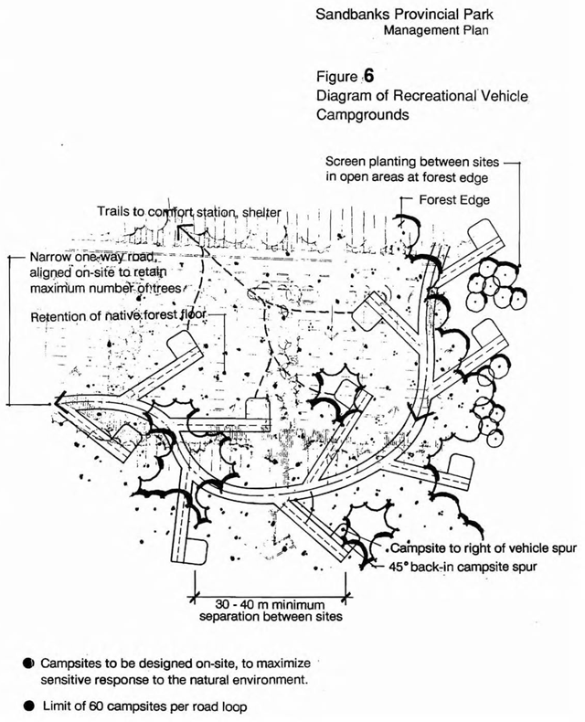
Reforestation and managed natural succession will be initiated before the development of this campground, to ensure vegetated buffers between sites and a natural environment within the campground.
Electrical hookups will be included at each campsite. Waste tank pumpouts will be located at a common area convenient to entering and exiting traffic.
The second proposed recreational vehicle campground will be developed near the West Lake Day Use Areas. This campground will be sized to prevent overuse of the West Lake beach resource. Preliminary indications are that approximately 60 serviced sites may be accommodated in the West Lake area without stressing the resource.
8.4.3 Group campsites
The existing group campsites will be retained. Environmental impacts on the shore of East Lake will be monitored and rehabilitation of the shore will be considered.
8.5 Day use areas and swimming beaches
8.5.1 Outlet each day use area
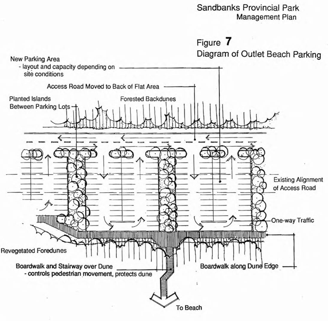
The day use area at Outlet Beach receives the most use of any area of the park. While the beach itself can sustain a high level of use without negative environmental impact the fragile foredunes between the day use parking areas and the beach itself are being severely damaged by recreational activity.
Trampling by day users walking between their cars and the beach is the main cause. The current parking arrangement along the entry road contributes to the degradation of the foredune by encouraging people to cross the dunes in a disorganized and dispersed manner. The parking lots may be described as chaotic during periods of high use, creating unsafe traffic and pedestrian conflicts. The latter condition is increased by the presence of parking on both sides of the access road. Day users must cross this road during heavy periods of both camper and day use arrivals and departures.
A reorganization and redesign of the parking areas and of the foredune crossings will be undertaken, in conjunction with dune stabilization, planting and rehabilitation. The goals of this reorganization are to allow stabilization and revegetation of the foredunes with natural cover, reducing wind scour and blowouts on the foredune and creating a more pleasant, safe and organized system of recreational access to the beach.
A site plan for the day use area at Outlet Beach will be prepared. This will include:
- relocation of the main access road to the back of the panne area behind the foredune;
- small parking areas organized on a one way loop system with lanes running perpendicular to the foredunes;
- a boardwalk running along the ends of the parking lots at the toe of the foredunes;
- collection points and defined dune crossing points using steps and elevated boardwalks where appropriate.
Figure 7 shows a schematic diagram of the reorganized day use parking areas. The selection of dune crossing points, together with pedestrian control systems and replanting of the dunes, will be subject to the comprehensive dune management plan.
8.5.2 MacDonald Farm day use area
The MacDonald Farm day use area is associated with an Historic Zone around the farm and the former wharf site. Site development will be limited to picnic sites on the point near the wharf, as well as a small parking area for 5-10 cars. This area will also serve as the access to the Lakeshore Trail and the Woodlands Trail to West Lake. Potential adaptive reuse and interpretation of the MacDonald farm buildings and the former wharf will be considered based on technical cultural heritage studies.
8.5.3 West Lake day use area
A new day use area is proposed for the West Lake beach area, on the site of the former Barrett property. This day use area is intended to take some of the swimming and beach use demand from Outlet Beach and to provide an optional swimming area for park users. It will also extend the swimming season for residents and visitors, as West Lake warms up sooner than Lake Ontario.
Site development will include change rooms and washroom facilities, a parking area, picnic sites with shelters on the backshore, a dock for the mooring and access of small craft from West Lake and a boardwalk trail to a dune observation tower. This tower will provide dramatic views over the West Lake dunes without encouraging uncontrolled access onto the dunes themselves.
Approved site plans will be required before the development of the day use area and the dune observation tower. The location of the tower and the access boardwalk will be subject to the recommendations of the dune management plan and the vegetation management plan.
8.5.4 West Point day use area
A small, passive, day use area will be developed in conjunction with the proposed visitor centre near the old Lakeshore Lodge site on West Point. This area will include minimal picnic facilities, along with cultural heritage interpretation and a small parking area at the beginning of the Lakeshore Trail.
A short interpretive trail will lead from the proposed visitor centre to the top of the nearby forested dune. A wood deck will be constructed on this dune to allow visitors to experience the dramatic views over the dunes and shoreline available from this point. The trail and deck will be designed to integrate sensitively with the site and to minimize damage to the dune by visitors and during construction. An approved site plan, as well as approved construction detailing and mitigation measures, will be required before construction of the dune observation deck.
8.6 Boat launching and mooring
There are currently very few opportunities for public launching of small craft onto Lake Ontario in the southwest area of Prince Edward County and none onto Athol Bay. This situation has led the boating public and elected representatives to ask the Ministry of Natural Resources to consider locating a public launch and mooring site on Athol Bay within Sandbanks Provincial Park.
After consideration of the backshore, shoreline and lake conditions on Athol Bay, it has been decided that any new public small craft launch facility on Athol Bay is not practical. There is a lack of a natural harbour of any kind in Athol Bay and the wind and wave conditions create very dangerous waters for launching and mooring small craft, particularly in stormy weather.
The site that received most attention was the historic MacDonald/Hyatt wharf site. This site is highly exposed to wind and wave action. The cost of creating a safe artificial harbour basin is judged to be exorbitant. Furthermore, the area required for parking and launching facilities on the backshore is not available at this site. Given a ramp’s probable popularity, the launch traffic would be incompatible with the uses in this area of the park. Use of this area by the few commercial fishermen active in the waters near the park can continue, subject to monitoring.
A facility for small craft mooring is included as part of the West Lake Day Use Area, allowing small craft to dock, but not launch, at the swimming beach and picnic area. The existing launching opportunity on the Outlet River is continued, subject to the restrictions outlined in Section 8.2.
8.7 Trails
A system of trails for hiking and cycling will be developed, ranging from short easy trails that are completely accessible, to long rugged hiking trails that may require several hours to complete.
The trail systems are shown on Figure 5 and include three types as follows.
Type A trails are wide hiking and/or cycling routes, with a well-graded and possibly paved surface and compacted sub-base, allowing safe and efficient cycle use and accessibility to wheelchairs. These trails run between high use areas and are fairly extensive in nature. Included in this group are the Lakeshore Trail, the Maple Lane Trail and the Woodlands Trail.
Type B trails are hiking trails only, more rugged and naturalistic than Type A trails and are oriented to nature appreciation and interpretation. Two of these loops are included: the existing Cedar Sands Trail and a new loop trail through the pannes and dunes of the Dunes Sector. These trails travel through sensitive natural environments and users are encouraged not to deviate from the surface of the trail itself.
Type C trails are short interpretive nature walks, which are generally not strenuous and are wheelchair accessible where terrain permits. These trails are related to the interpretation of a natural community or landscape. Two of these trails are proposed, one that leads from the Lakeshore Lodge to a dune observation point and one that loops through the mature maple woodlots.
Besides these trails, the existing cross country ski trails in the plantation area of the dunes near the current Campground ’D’ will be maintained and upgraded appropriately. Selected park roads, such as in campground and day use areas, can also be left unplowed to allow cross-country skiing opportunities.
8.8 Cultural heritage interpretation facilities
The current park museum and visitor centre are inappropriately located. The former Lakeshore Lodge site near West Point will more evenly distribute use in the park and offer associated historic and prehistoric themes. An alternative location could be on the site of the MacDonald House or Gray House. The functions of the park museum and visitor centre should be located in a new visitor centre which:
- reflects the historic character of the park’s early architecture;
- retains the historic traces of the old lodge;
- does not have impact on the nearby archaeological resources;
- encourages high quality interpretive programming and visitor services.
An approved site selection plan and site plan are required in locating and developing this new park visitor centre.
Cultural heritage interpretation in the entire park will be enhanced. There are several additional facilities that may be conserved to ensure the cultural heritage value of the park is appropriately interpreted and presented. These facilities include the MacDonald farm, the MacDonald / Hyatt wharf site, the Gray House (Lakeview Lodge) and the Barrett House, restored in 1998/1999. Conservation of all cultural heritage facilities will be guided by appropriate technical cultural heritage studies.
8.9 Park administration and headquarters
A new park headquarters and administration building will be developed in a more central location. The current location along the road to Outlet Beach reinforces the perception that Sandbanks Provincial Park is primarily centred on the Outlet Sector. The current location is not at the central distribution point for visitors to the park, once the proposed new park entrance road is in place. The current location is also constrained by limited parking facilities, especially during the hectic campsite roll-call period.
A proposed location for the park headquarters is shown on Figure 5 near the proposed gatehouse on the park entrance road. An alternative location could be at the site of the MacDonald House. A site selection plan and site plan will be prepared before locating a new site for this facility.
Chapter 9: Implementation policies
Facility improvements, studies and resource management plans discussed in this management plan are listed below in the order that they should be completed. Ministry of Natural Resources’ priorities and budgets will determine when projects can be undertaken. However, the activities of the newly forming Friends of Sandbanks organization could accelerate the interpretive content of these phases. All development work, including new facilities, roads, campgrounds, day use areas, interpretation and trail systems, will follow approved site plans and are subject to available funding.
9.1 Phase 1
This phase includes initiatives that should receive early attention, provide protection of park resources and create a framework for the future development of the park.
- Develop new park entrance and access road alignment, including gatehouse, dedicated entry and exit lanes, turnaround and appropriate sign system.
- Revise the parking and beach access at the Outlet Beach Day Use Area.
- Implement scenic drive system in the Woodlands Sector.
- Prepare dune management plan including recommendations for campsite closures, dune crossings and the use of snow fencing.
- Prepare vegetation management plan including natural regeneration corridor and monitoring programs.
- Implement motorboat restrictions on the Outlet River.
- Develop small parking areas and picnic facilities at the MacDonald Farm and West Point (Lakeshore Lodge).
- Develop parking area, picnic area and swimming beach at West Lake.
- Develop utility infrastructure for Woodlands Sector including water supply and sewage disposal facilities
- Develop exit-only outlet at former Barrett property, using automated gate.
9.2 Phase 2
This phase covers the implementation of new park facilities and the upgrading of existing facilities to distribute park use and to protect and interpret park resources.
- Initiate hiking and cycling trail network, including the Lakeshore, West Point, Woodlands and Maple Lane segments.
- Develop new recreational vehicle (RV) campgrounds in the Woodlands Sector.
- Remove selected campsites from Outlet Sector Campgrounds.
- Rehabilitate group campground and existing Campground ’D’.
- Complete the development of the West Lake Day Use Area.
- Implement the dune observation tower near West Lake, with the Dunes Interpretive Trail.
- Develop new park headquarters.
9.3 Phase 3
This phase covers further initiatives that complete the implementation of the Management Plan.
- Construct a new visitor’s centre in the West Point area.
- Construct dune observation deck and interpretive trail near West Point.
- Complete overall park trail system.
- Close landfill site.
- Demolish Gray and MacDonald houses.
Chapter 10: Summary of public consultation on the 1992 management plan
10.1 Opportunities for public consultation
The planning process included many opportunities for the public to be participants in the preparation of this Management Plan.
These opportunities are listed in the general sequence followed.
- Fall 1990 to Spring 1991 — Informal meetings between the consultant and representatives of over twenty focal and regional interest groups; including tourism, environmental, recreation, landowner and heritage organizations.
- Spring, 1991 — Informal contacts by the consultant with agencies having an interest in the park, including provincial ministries, county and township leaders and the Ontario Provincial Police.
- February, 1991 — Initial public meeting in Picton, chaired by the county and townships, providing consultant presentations of the work in progress and question and answer periods.
- March, 1991 — Initial Dunes newsletter, prepared by the consultant and mailed to those who had expressed an interest in the planning of the park and distributed at public meetings. This newsletter offered summaries of what the people were saying about the park, discussions of the issues being addressed, descriptions of the choices for the future and surveys of opinions and ideas.
- March, 1991 — Second public meeting in Picton, chaired by the county and townships, providing consultant presentations of the work in progress and question and answer periods.
- May, 1991 — Field tour of proposed park, with consultant review of proposed entrance revisions with County Roads Committee and ministry staff.
- January, 1992 — Preliminary Management Plan, prepared by consultant and circulated by the ministry to the mailing list and advertised for general public review.
- February to April, 1992 — ministry staff and council discussions on public responses to the Preliminary Management Plan and options for resolving areas of concern.
- May, 1992 — Second Dunes newsletter, written by ministry staff and mailed to those who had expressed an interest in the planning of the park. This issue offered the public a summary of the negotiated changes to the Preliminary Management Plan and solicited further comments.
10.2 Summary of public responses
10.2.1 Initial comments from meetings
Members of environmental, heritage and conservation groups were concerned about many existing and potential problems, including:
- the need to base development decisions on a clear understanding of resource capabilities and not just public demand;
- the importance of educating park visitors about ecosystems and resource sensitivity;
- recognition of boating traffic in West Lake and the need to address control of access to the Sandbanks sector by boat;
- the need for a greater presence among park staff throughout the park, especially in the Sandbanks sector where the resources have not yet been subject to over-use;
- the opportunity for the ministry to establish new solid waste management approaches;
- preservation and re-use of heritage resources and stopping the accelerated decline of old buildings through poor maintenance;
- incompatibility of mechanized water sports with the natural environment characteristics of the park;
- need to promote better non-mechanized trail opportunities for more passive enjoyment and understanding of park values;
- incompatibility of previous private lodge development proposals with the public objectives of the park;
- desire to see agricultural landscape continue.
Tourism and economic development organizations identified important concerns and opportunities, including:
- a high degree of praise for the Ministry of Natural Resources cooperative efforts to cross-promote the park and other county attractions. The groups would like to see this effort keep pace with the other aspects of enhanced park management;
- a desire that the park management plan take into account a full awareness of economic benefits and objectives and recognize special efforts for enhancing the shoulder seasons;
- a perception among too many county residents that tourism is problematic rather than beneficial, or that municipalities tend to wait for provincial funding before “pulling together” more to enhance the impact of local activities;
- a concerted effort to provide much higher quality camping and/or other accommodation for tourists in the park, without creating unfair, subsidized competition with the private sector;
- a special effort to actually reveal and interpret the most striking dunes to the public, as most visitors never see them;
- government action in resolving water quality problems and not just creating bad publicity and misunderstanding with potential tourists, or a lack of faith among local residents.
People in other provincial and local agencies mentioned some points that are of interest in planning the park, including the:
- need for refurbishing many of the county’s and the park’s, facilities on behalf of the travelling public;
- resolution of traffic and parking congestion at the present park entrance, which leads to other problems of trespass and safety;
- importance of avoiding perpetuation of agriculture in the face of unrealistic business conditions, or of treating it as a pastoral landscape feature having no conflicts with outdoor recreation.
Meetings were held also with county and township leaders and staff members. Thereafter, a meeting was held on February 19, 1991 with county residents at the Picton Community Centre. A good understanding was gained of what the residents were thinking about the park, especially from those people not represented by a particular interest group.
People living in the county and especially those living in Athol and Hallowell townships, are interested in the future of the park and voiced a number of issues they wished to see addressed, including the:
- legality of any contemplated public road closures within the park, considering county ownership;
- continued right of access to private property along such roads;
- continued public access to Lake Ontario;
- continuation of local school bus, trash collection, mail delivery, snow plowing and road maintenance services given such closures;
- continued access to and enjoyment of the park by residents, not just visitors, with opportunities for hiking and bicycling within and between both sectors;
- short and long term status of the ministry’s solid waste disposal site within the park;
- degree of additional development of the park (not too little, not too much);
- recognition of traffic impacts outside the immediate park area, caused by tourists drawn to the county because of the park;
- recognition of the great importance of such tourists to the economic health of the county;
- the commitment of relevant agencies, not just the Ministry of Natural Resources, to find the cause of water quality problems and to prevent repetition of beach postings.
The above issues and concerns were addressed in the consideration of options and the preparation of the Preliminary Management Plan.
10.2.2 Responses to preliminary management plan
Two issues emerged from the public review of the Preliminary Management Plan.
Park road changes
The Preliminary Management Plan proposed changes to the Woodland Sector road network. For the ten year lite of the plan, a one way system was proposed, coupled with a new park entrance and other modifications. A Future Planning Option, for the longer term view, posed the vision of a car-free zone along the lakefront, dedicated as a pedestrian and bicycling greenway connecting the Outlet and Dune Sectors. This idea provided for a separate access lane along the rear yard portions of the residential lots. The full width of the shoreline area would then become a corridor dedicated to public access and enjoyment uninhibited by roads or traffic.
While this long range option was misinterpreted by many people as being an immediate proposal for park changes, clearly there was strong opposition to it for any time in the park’s future.
Sand dune access
The Preliminary Management Plan contained proposed restrictions on recreational use of the sand dunes in the Dunes Sector. Nature Reserve zoning and access limitations were proposed to protect the park’s most famous resource. Public enjoyment was to be provided for with a loop trail and boardwalk system giving access to a portion of the dune and panne environment. An observation tower was also proposed to offer long range views and interpretation of the sandbanks, with easy access from the nearby West Lake Day Use Area facilities.
There was some public disagreement with the necessity of protecting sandbanks that were subject in any case to natural erosion and movement. There was greater disagreement with the restriction of trail access into the sandbanks themselves. Local users had been using the northern stretches of the sandbanks for quiet enjoyment with little impact for years. They felt that denial of access was simply too severe a measure without documented damage over time.
10.3 Changes to the management plan
Ministry staff discussions with the county and townships sought compromise solutions in response to the public. Thereafter, ministry staff directed the consultant to make a number of revisions.
10.3.1 Woodland sector road system
- delete reference to the Future Planning Option.
- maintain the new entrance proposal.
- redevelop the corridor along the lake as a scenic drive, extending it further south toward West Point and incorporating roadside picnic stops. West Point itself would not be encroached upon by the parkway. Access to the drive and roadside stops would be free. Car entry to adjacent day use areas and campgrounds would be subject to user charges. In this way, driving along the scenic road would be kept available to county residents.
- close Maple Lane to vehicular traffic, converting it to a heritage trail for pedestrian and cycling use.
- maintain the proposed new road between the former Barrett property and the MacDonald property.
- keep all retained or new roads in the Woodland Sector two-way.
The scenic drive and other road proposals provided in this plan reflect these directions.
10.3.2 Sandbanks protection and access
- retain the Nature Reserve Zone.
- permit continued public access through carefully planned and located trails.
- foster public understanding and appreciation of the significance and sensitivity of this area of the park.
- monitor the impacts of use over time and take appropriate action if unacceptable damage occurs.
The provision of continued trail access, coupled with a monitoring program and the flexibility to take further action if required, has been incorporated into this Management Plan.
10.4 Future opportunities for public consultation
The Management Plan will be subject to review every ten years and will include public consultation. The success of the present plan, the need for change and the changes themselves will involve public review and response opportunities. In addition, two other mechanisms have emerged during the review of the Preliminary Management Plan.
10.4.1 Community forum
During the planning period, several individuals and groups, as well as park staff, expressed a desire to have a better mechanism by which problems, issues, or concerns could be resolved. A Community Forum, with representatives from each township, the county, park residents, park staff and others, is recommended as part of this Management Plan.
10.4.2 Friends of Sandbanks
A new community support group, The Friends of Sandbanks, is being formed. The Friends of Sandbanks organization will be composed principally of local residents who will assist the park in developing programs and educational materials. Its objective will be to help visitors and county residents become more aware of the importance of the natural and cultural history of Sandbanks Provincial Park.
Chapter 11: Summary of consultation on the 2021 amendment to the management plan
11.1 Opportunities for consultation
Ontario Parks posted a policy proposal notice for the proposed park management plan amendment on the Environmental Registry of Ontario for a 45-day comment period. Indigenous communities, adjacent landowners and stakeholders and were notified directly of the proposed amendment to the management plan.
11.2 Summary of responses
A total of five comments were received during the consultation period; 3 opposed and 2 neutral. Most of the opposition was in regard to the loss of buildings from the landscape. A Cultural Heritage Evaluation Report and a Heritage Impact Assessment were produced for both buildings and concluded that the buildings should be demolished due to their advanced state of disrepair. Also, the reports indicated that the cultural heritage value of the buildings could be adequately commemorated through mitigation strategies such as the creation of interpretive panels.
11.3 Changes made to the management plan
Because of comments received, minor wording changes were made throughout the management plan to more closely match terms used by the Ministry of Heritage, Sport, Tourism and Culture Industries, including removing intent to prepare a cultural resources management plan for the park. Cultural heritage resources management is based on technical cultural heritage studies and a cultural resources management plan is not required. Ontario Parks commits to commemorating the buildings as guided by the Heritage Impact Assessments.
Chapter 12: References
Commonwealth Heritage Resources Ltd. 1991. Sandbanks Provincial Park Cultural Resources Study.
Laventhol and Horwath. 1987. Sandbanks Resort Hotel. Unpublished report.
Law, Jane. 1989. The Sandbanks Dune / Bay Barrier Complex. Prince Edward County Ontario. Morphology and Change Over the Past 1200 Years. Unpublished Ph.D. dissertation, University of Waterloo.
Law. Jane. 1991. The Geomorphology of Sandbank’s Provincial Park. Unpublished report prepared for the Ministry of Natural Resources.
Letourneau Heritage Consulting Inc. 2019. Heritage Impact Assessment: Site Number 13, Hyatt House, Sandbanks Provincial Park, Picton, Ontario. Project #LHC0148
Letourneau Heritage Consulting Inc. 2019. Heritage Impact Assessment: Site Number 17, MacDonald House, Sandbanks Provincial Park, Picton, Ontario. Project #LHC0184
Letourneau Heritage Consulting Inc. 2020. Cultural Heritage Evaluation Report: Site #13 (Hyatt House), Sandbanks Provincial Parks, Picton ON (revised). Project #LHC0048
Letourneau Heritage Consulting Inc. 2020. Cultural Heritage Evaluation Report: Site #17 (MacDonald Farm), Sandbanks Provincial Parks, Picton ON (revised). Project #LHC0048
Marshall Macklin Monaghan. 1983. Lakeshore Lodge. Prince Edward County, Development Concept and Feasibility Study. Unpublished report.
Marshall Macklin Monaghan. 1984. Prince Edward County: An Opportunity for Tourism Investment.
Marshall Macklin Monaghan. Prince Edward County Tourism Master Plan. Unpublished, undated report.
McKenna, E. 1981. Shifting Sands: cultural landscapes. Provincial parks and the case of Sandbanks in M. Fram and J. Weiler, editors: Continuity with Change. Ontario Ministry of Culture and Recreation.
M. Dillon Limited. 1988. Loyalist Parkway Master Plan. Unpublished report.
Norris T. and O. Cuddy. An Evaluation of the Life Sciences Resources of Sandbanks Provincial Park. Unpublished draft report. Kemptville: Ministry of Natural Resources, Eastern Regional Office. 1990.
Ontario Ministry of Natural Resources. 1987. Ontario Provincial Parks Management Planning Reference. Toronto: Parks and Recreational Areas Branch.
Ontario Ministry of Natural Resources. 1990. Sandbanks Provincial Park Management Planning Background Information and Issues. Kemptville: Provincial Parks, Eastern Regional Office.
Ontario Ministry of Natural Resources. 1990. 1990 Day User Survey, Sandbanks Provincial Park. Preliminary Report. Parks Branch, Toronto.
Ontario Ministry of Natural Resources. 1990. 1990 Camper Survey — Sandbanks Provincial Park. Preliminary Report. Parks Branch, Toronto.
Ontario Ministry of Natural Resources. 1979. Sandbanks Provincial Park Master Plan. Toronto: The Queen’s Printer.
Past Recovery Archaeological Services Inc. 2015. Stage 1 Archaeological Assessment of Sandbanks Provincial Park, Prince Edward County, Ontario.
Totten Sims Hubicki Associates. 1988. Transportation Study — Park Access, Sandbanks Provincial Park, Prince Edward County. Unpublished report.