Schedule A - Order in Council 276/2024
Order in Council 276/2024
Appendix A
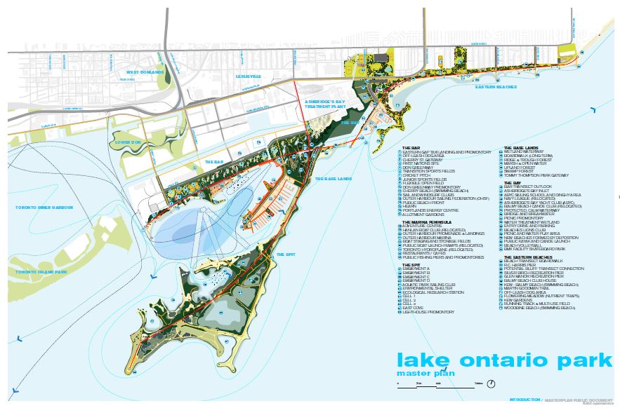
Lake Ontario Park
This map shows a master plan for the proposed Lake Ontario Park, located in Toronto along the shore of Lake Ontario, bounded by the most westerly point of Tommy Thompson Park and the Eastern Gap Taxi Landing and Promontory to the R.C. Harris Water Treatment Plant in the Eastern Beaches, including lands east of Toronto Inner Harbour and south of the West Donlands, Leslieville, and Ashbridge’s Bay Wastewater Treatment Plant. It includes the location of 75 proposed features in 6 areas: the Bar, the Marina Peninsula, the Spit, the Base Lands, the Bay, and the Eastern Beaches
- The Bar
- Eastern gap taxi landing and promontory
- Off-leash dog area
- Cherry St. Gateway
- First nations site
- Don greenway
- Transition sports fields
- Cricket pitch
- Junior sports fields
- Flexible open field
- Don greenway promontory
- Cherry beach (swimming beach)
- Sail and windsurf clubs
- Outer Harbour Sailing Federation (OHSF)
- Public beach front
- Hearn
- Portlands energy centre
- Allotment gardens
- The Marina Peninsula
- Adventure centre
- Hanlan boat club (relocated)
- Outer harbour promenade & landings
- Outer harbour marina
- Boat staging and storage fields
- Public boat launch ramps (relocated)
- Toronto hydroplane (relocated)
- Restaurants / cafes
- Public fishing piers and promontories
- The Spit
- Embayment a
- Embayment b
- Embayment c
- Embayment d
- Aquatic park sailing club
- Environmental shelter
- Ecological research station
- Cell 1
- Cell 2
- Cell 3
- East cove
- Lighthouse promontory
- The Base Lands
- Wetland waterway
- Boardwalk (long-term)
- Ridge & trough forest
- Marsh & open water
- Upland forest
- Swamp forest
- Tommy Thompson park gateway
- The Bay
- Bar transect outlook
- Ashbridge’s bay inlet
- ABYC sailing school and dinghy area
- Navy league (relocated)
- Ashbridge’s bay yacht club (ABYC)
- Balmy beach canoe club (relocated)
- Protected, calm waterway
- Bridge and breakwater
- Picnic promontory
- Water treatment wetland
- Entry drive and parking
- Beaches lions club
- Picnic and water play area
- New beaches formed by deposition
- Public kayak and canoe launch
- Beach volleyball
- BMX facility skateboard park
- The Eastern Beaches
- Beach transect boardwalk
- R.C. Harris pier
- Potential bluff transect connection
- Silver birch recreation pier
- Glen manor recreation pier
- Balmy beach club house
- Kew - balmy beach (swimming beach)
- Martin goodman trail
- Off-leash dog area
- Flowering meadow (nutrient traps)
- Kew gardens
- Running track & multi-use field
- Woodbine beach (swimming beach)
Updated: March 01, 2024
Published: March 01, 2024