Shack Creek Wetland Conservation Reserve Management Statement
This document provides policy direction for the protection, development and management of the Shack Creek Wetland Conservation Reserve and its resources.
Statement of Conservation Interest (C96)
Ministry of Natural Resources
Parry Sound District
Prepared with the assistance of:
Meteek & Company
Huntsville, Ontario
March 2005
Approval statement
We are pleased to approve this Statement of Conservation Interest for Shack Creek Wetland Conservation Reserve (C96).
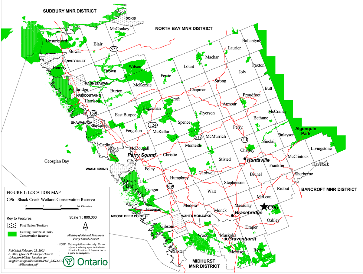
Shack Creek Wetland Conservation Reserve consists of 288 hectares of Crown land, located in McLean Ward and Oakley Ward in the Municipality of the Town of Bracebridge in the District Municipality of Muskoka. It is located about 17 kilometres east of the town centre of Bracebridge and about 3 kilometres west of Bigwind Lake Provincial Park. The site lies just north of Fraserburg Road about 2 kilometres east of the village of Fraserburg.
Shack Creek Wetland Conservation Reserve, located in ecological Site District 5E-8, protects the Crown land portions of the Shack Creek Wetland area that has been recognized as significant for over a decade. The wetland has been determined to be provincially significant and has been municipally identified as a Muskoka Heritage Area.
The conservation reserve is surrounded on most sides by private lands, and public access is limited
Shack Creek Wetland Conservation Reserve is one of 378 new protected areas approved through Ontario’s Living Legacy Land Use Strategy, aimed, in part, at completing Ontario’s system of parks and protected areas.
During the "Lands for Life" planning process, the public was widely consulted and provided valuable input into what became Ontario’s Living Legacy Land Use Strategy. Comments received during that time, and during consultation related to the formal Public Lands Act regulation of the boundaries of this conservation reserve, were generally supportive of the protection of this area. Stakeholders who provided comment during the earlier consultation for this site were subsequently consulted regarding the draft Statement of Conservation Interest and any comments were considered in the finalization of this document.
This Statement of Conservation Interest provides guidance for the management of the conservation reserve and provides the basis for the ongoing monitoring of activities. More detailed direction is not anticipated at this time. Should more complex resource management or conservation issues arise or significant facility development be considered, then a detailed Resource Management Plan will be prepared with full public consultation.
Shack Creek Wetland Conservation Reserve is managed under the direction of the District Manager and the Bracebridge Area Supervisor of the Ministry of Natural Resources, Parry Sound District.
Approved by:
R. Griffiths
District Manager
Parry Sound District
Approved by:
Ron Running
Regional Director
Southern Region
Figure 1: Location of Shack Creek Wetland Conservation Reserve
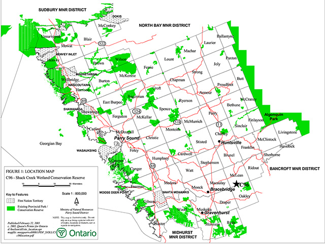
Enlarge figure 1 location map of Shack Creek Wetland Conservation Reserve
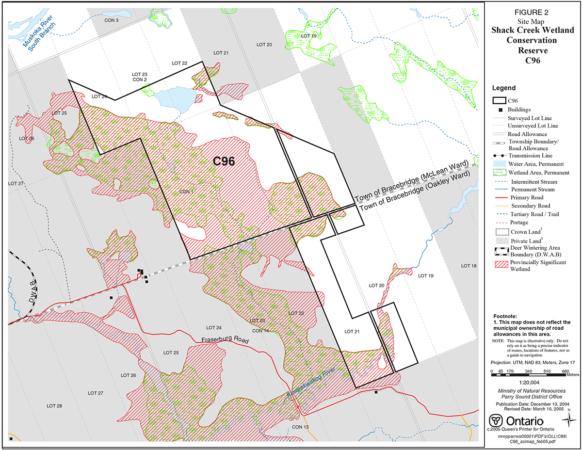
Figure 2: Site Map – Shack Creek Wetland Conservation Reserve

Enlarge figure 2 site map of Shack Creek Wetland Conservation Reserve
1.0 Introduction
Ontario’s Living Legacy, the result of an extensive planning process that began in early 1997, culminated in the approval in July 1999 of a Land Use Strategy that identifies the intended strategic direction for Crown land in central and northern Ontario, including the completion of Ontario’s system of parks and protected areas. This process, which included public consultation, resulted in the recommendation for regulation of 378 new protected areas, including Shack Creek Wetland Conservation Reserve (C96).
Shack Creek Wetland Conservation Reserve consists of 288 hectares of Crown land, located in McLean Ward and Oakley Ward in the Municipality of the Town of Bracebridge in the District Municipality of Muskoka. It lies about 17 kilometres east of the town centre of Bracebridge and about 3 kilometres west of Bigwind Lake Provincial Park. The site lies just north of Fraserburg Road about 2 kilometres east of the village of Fraserburg.
Shack Creek Wetland Conservation Reserve was considered as a candidate Area of Natural and Scientific Interest (ANSI) in 1991, (OMNR, 1993; Brunton, 1991), with the ANSI report stating that the site has been considered significant since at least the 1970's (Brunton, 1991). The entire wetland area was also determined to be a provincially significant wetland using the Ontario Wetland Evaluation System Northern Manual (1993) in 2002. Much of the conservation reserve is a small part of a municipally identified Muskoka Heritage Area (Reid and Bergsma, 1994).
Shack Creek Wetland Conservation Reserve, being limited to Crown land, does not cover all of the provincially significant wetland or the Muskoka Heritage Area, but it does provide a good representation of these designations.
Big game (moose, deer, bear) hunting is a traditional use of the conservation reserve and its surrounding lands. The site may also be used for angling and for waterfowl hunting.
Conservation reserves are established under the authority of the Public Lands Act, Ontario Regulation 805/94. Shack Creek Wetland Conservation Reserve was established by Ontario Regulation 86/01 on April 21, 2001.
A Statement of Conservation Interest (Statement of Conservation Interest) is prepared under the direction of Procedural Guideline A – Resource Management Planning (PL. Procedure 3.03.05). The purpose of this Statement of Conservation Interest is to identify and describe the values of Shack Creek Wetland Conservation Reserve. The Statement of Conservation Interest also outlines the activities that currently occur within the conservation reserve and provides guidelines for the management of current and future activities in the context of protecting the natural, recreational and cultural values.
1.1 Background information:
| Name | Shack Creek Wetland Conservation Reserve (C96) |
|---|---|
| Site Region/District | Georgian Bay Site Region, Site District 5E-8 |
| OMNR Administrative Region/District/Area | Southern Region/ Parry Sound District/ Bracebridge Area |
| Total area (ha.) | 288 hectares |
| Regulation date | April 21, 2001 (O. Reg. 86/01) |
| First Nations | Robinson-Huron Treaty and Williams Treaty |
| OBM map sheets | 10 17 6490 49940 |
| Topographic map | Bracebridge 31 E/3 |
| UTM co-ordinates | 10 17T 64937 499391 (Centroid) |
1.2 Representation
Earth science representation:
Bedrock
Migmatitic quartzofeldspathic and minor mafic gneisses derived from monzogranite and diorite/gabbro of the Fishog Domain, Algonquin Terrane in the southeastern part of the Central Gneiss Belt of the Proterozoic Grenville Province.
Surficial
Recent swamp and organic deposits, with small isolated areas of bedrock covered with very thin till of ground moraine, and glaciofluvial deposits of sand and gravel.
Life science representation:
Shack Creek Wetland Conservation Reserve provides representation of wetland habitat in ecological Site District 5E-8, and contributes to meeting site district objectives for the protection of 9 specific landform/vegetation combinations. The Shack Creek complex, part of which is within the conservation reserve boundaries, is a provincially significant wetland, and a Muskoka Heritage Area.
Cultural resources representation:
Neither detailed cultural research nor inventory has been carried out for this conservation reserve.
Recent regional evaluation (OMNR, 2003) shows that the nearby South Branch of the Muskoka River, and the Kawpakwakog River contain areas that have a high potential for cultural heritage sites.
Recreational opportunities:
A recreational inventory report was prepared for this site based on existing knowledge and data sources of MNR staff and several site visits (Gavel, 2003). Currently, it is used for big game hunting, and perhaps also for waterfowl hunting and angling. The low wet nature of most of the site precludes most trail activities.
1.3 Survey work
| Survey Level | Earth science | Life science | Cultural | Recreational | Other |
|---|---|---|---|---|---|
| Reconnaissance | Duba & Frey, 2001 | Brunton, 1991 Reid and Bergsma,1994 Eggers, 2003 |
OMNR, 2003 | Gavel, 2003 | None |
| Detailed | None | None | None | None | None |
| Requirement | None | Monitor the status/presence of significant species and associations. | Research to be encouraged | Monitor use impacts | None |
2.0 Values to be protected
The conservation reserve is located entirely within Hills' (1959) ecological Site District 5E-8. Values include earth science, life science and recreational/aesthetic values, with an emphasis on the life sciences.
2.1 Earth science:
(Earth science information, unless otherwise noted, is taken from Duba & Frey, 2001)
Bedrock:
Shack Creek Wetland Conservation Reserve is an area of wetlands with limited bedrock exposure. A northwest trending regional fault transects the southern part of the conservation reserve. Several northeast sections of the Kawpakwakog River are structurally controlled and defined by this fault. The bedrock, where it is exposed, is migmatitic quartzofeldspathic and minor mafic gneisses derived from monzogranite and diorite/gabbro of the Fishog Domain, Algonquin Terrane in the southeastern part of the Central Gneiss Belt of the Proterozoic Grenville Province (Lumbers & Vertolli, 2000).
The Fishog Domain is underlain by older migmatitic tonalitic to diorite gneisses of unknown protolith and metasedimentary derived silicaceous and calc-silicate gneisses. They are intruded by monzonitic plutons. Most of the gneisses are in turn intruded by granodiorite and magnetite–bearing syenogranite plutons inferred to represent a 1.35-1.32 billion year old magmatic episode. Structurally the gneisses and migmatites form septa between elongated domes of the larger plutons. Near the eastern boundary of the domain, these structures are stretched parallel to the intensely deformed rocks of the Central Metasedimentary Belt Boundary Zone and develop a southeast-plunging lineation. The known metamorphic grade within the Fishog Domain is primarily upper amphibolite. The apparent absence of granulite grade metamorphism distinguishes the Fishog Domain from most of Algonquin Terrane. The Fishog Domain is characterized by its distinctive, strong magnetic signature and plutonic suite suggesting that the tectonic unit (terrane) may be allochthonous (i.e. found in a place other than where they and their constituents were formed) within the Central Gneiss Belt (Easton, 1992a & b)."
The Grenville Province is the product of thrusting and imbrication of the crust to the northwest as it collided with a continental landmass to the southeast. The Grenville Orogeny, circa 1140 to 1070 million years ago, culminated more than 500 million years of crustal evolution. The eroded roots of the products of these events are displayed in the complexly metamorphosed and deformed rocks of the region (Easton, 1992b).
The Algonquin Terrane is one of the four lithotectonic terranes of the Central Gneiss Belt. The Fishog Domain is one of twelve structural domains of the Algonquin Terrane. This geological environment is part of the modern organization of the complex products of the mid-Proterozoic orogenic events (Easton 1992a & b). As such, their representation in Shack Creek Wetland Conservation Reserve contributes to the conservation of the Grenville Province continental accretion theme (Davidson, 1981).
Within the Ontario Provincial Park system, the bedrock geological features observed in Shack Creek Wetland Conservation Reserve are regionally significant in their representation of components of the Fishog Domain, Algonquin Terrane.
Surficial:
The Quaternary deposits are Late Wisconsinian in age. Recent swamp and organic deposits (Bajc & Henry, 1991) underlie most of the conservation reserve. Small isolated areas of bedrock covered with a thin till of ground moraine occur in the north and northeast parts. Smaller patches of glaciofluvial ice-contact stratified deposits of sand and gravelled glaciofluvial outwash sediments occur in the centre and southeastern areas. Surficial geology of the conservation reserve is locally significant.
2.2 Life science:
(Life science information, unless otherwise noted, is taken from Eggers, 2003)
The conservation reserve is located within Hills' (1959) ecological Site District 5E-8. Life science significance is determined on the basis of the following criteria: representation, diversity, condition, ecological considerations and special features (Crins and Kor, 1998).
Representation:
This site was identified during the Ontario’s Living Legacy selection process for representation of wetland habitat. It is a provincially significant wetland and a Muskoka Heritage Area. The site also contributes to meeting site district objectives for the protection of 9 specific landform/vegetation combinations, as identified during natural heritage gap analysis.
The Shack Creek Wetland was considered as a candidate Area of Natural and Scientific Interest (ANSI) in 1991, (OMNR, 1983; Brunton, 1991), with the ANSI report stating that the site has been considered significant since at least the 1970's (Brunton, 1991); this candidate ANSI designation no longer applies. The entire wetland area was also determined to be a provincially significant wetland (PSW) using the Ontario Wetland Evaluation System Northern Manual (1993) in 2002. The Shack Creek Wetland is a Muskoka Heritage Area (Reid and Bergsma, 1994).
Shack Creek Wetland Conservation Reserve, being limited to Crown land, does not cover all of the PSW or Muskoka Heritage Area, but it does provide a good representation of these designations. The conservation reserve is essentially a continuous area, with parcels separated only by unopened municipal road allowances. The boundaries of the conservation reserve were regulated before the formal wetland evaluation was carried out and were based on the more generalized wetland boundaries of the time; for this reason several small peripheral areas of the provincially significant wetland on Crown land are not included within the conservation reserve.
Three landform types are represented within the conservation reserve: very weakly broken peat plains [VIIIa-1]; moderately broken shallow sandy till uplands (bare bedrock) [Ia-37]; and weakly broken lacustrine deltaic sand plain [IVd-1] (Noble, 1983) .
There are five vegetation associations in the conservation reserve which are unique or of limited distribution in Muskoka, namely trembling aspen-northern conifer forest, eastern white cedar swamp forest, graminoid pool fen, black spruce treed bog, and black spruce-sphagnum-Labrador tea Intermediate fen (Reid & Bergsma, 1994).
Condition:
Access by road and trail is limited within the conservation reserve, owing to the wetland nature of the site. An unauthorized dam impounds an unnamed lake on Lot 22/23, Concession 2, McLean Ward. There is a road over private land that comes close to (but not within) the southern boundary of the conservation reserve, otherwise there is no road access to the site. There is a walking/all-terrain vehicle trail that connects the unnamed lake on Lot 22/23, Concession 2, McLean Ward with a road over private land that eventually accesses the Fraserburg Road. There are unauthorized all-terrain vehicle trails within the conservation reserve that appear to be related to hunting use.
The site is in good condition, since it has a very low proportion of introduced species, high quality wetland habitat, and anthropogenic disturbances are limited to the presence of the dam (which slightly alters the hydrology of the site), and the all-terrain vehicle trails (which are only in the upland areas and used mostly during the hunting season).
Diversity:
According to Forest Resources Inventory information, black spruce (Piceae mariana), balsam fir (Abies balsamaea), and tamarack (Larix laricina) are common in the coniferous bogs, and sugar maple (Acer saccharum), red maple (Acer rubrum), yellow birch (Betula alleghaniensis), basswood (Tilia americana), white birch (Betula papyrifera), white pine (Pinus strobus), and hemlock (Tsuga canadensis) are common on upland areas.
During a 1993 Natural Heritage Evaluation of the Shack Creek Wetland, 170 vascular plants were recorded, including three rare species.
A partial list of ecosites represented in the conservation reserve can be compiled by interpreting information from Forest Resources Inventory mapping and the Natural Heritage Evaluation (Reid & Bergsma, 1994), based on the Field Guide to Forest Ecosystems of Central Ontario (Chambers et al., 1997). Ecosites are classified based on recurring patterns of vegetation, soil, climate and topography on the landscape. An ecosite classification system has only been developed for the forest ecosystems of central Ontario, although many wetland ecosites are present in the region. Some forest ecosites represented in Shack Creek Wetland Conservation Reserve are: ES20.2 (fresh to moist white pine-red pine-white spruce-white birch-trembling aspen); ES27.2 (fresh to moist sugar maple-white birch-poplar-white pine); ES28.2 (fresh to moist sugar maple-hemlock-yellow birch); ES29.2 (fresh to moist sugar maple-yellow birch); ES31 (very moist to wet black spruce-tamarack); and ES32 (very moist to wet white cedar-black spruce-tamarack).
Completion of natural heritage gap analysis revealed that there are 14 representative combinations of vegetation and landform present in Shack Creek Wetland Conservation Reserve. The gap analysis project involved identifying vegetation and landform combinations that were not adequately represented in protected areas at the time, so that sites chosen for Ontario’s Living Legacy could protect more of these combinations. The site was not chosen expressly for protection of specific landform/vegetation combinations, although 9 of its 14 combinations make critical contributions to meeting the goals for protection of these combinations in the site district (Ontario Parks, 2003).
From a wildlife perspective, the conservation reserve supports good populations of big game such as moose (Alces alces), white-tailed deer (Odocoileus virginianus), and black bear (Ursus americanus). The wetland evaluation noted the presence of beaver (Castor canadensis), mink (Mustela vison), and muskrat (Ondatra zibethicus), which are important furbearers in Ontario. The wetlands and waterbodies of the site provide suitable habitat for waterfowl breeding. Four mammal species were observed during the Natural Heritage Evaluation, as well as 48 species of birds (during breeding season), 7 species of herpetofauna, 4 species of butterfly, and 7 species of dragonfly (Reid and Bergsma, 1994).
Ecological considerations:
The conservation reserve encompasses excellent ungulate summer cover, as there is much evidence of moose and deer in the area. The wetland is connected to the Kawpakwakog River (a portion of which is within the conservation reserve), and is also connected to the South Branch of the Muskoka River, thus it contributes to regional hydrological systems through both ground and surface water storage and recharge.
Special features:
The presence of black-backed woodpecker (Picoides arcticus), which is provincially ranked S4 (uncommon) but is regionally rare, was noted in the conservation reserve (Reid and Bergsma, 1994). Rare flora found within the site include: long sedge (Carex folliculata) (ranked S3 – provincially rare); and indian paintbrush (Castilleja coccinea) and marsh horsetail (Equisetum palustre), both ranked S5 (common) but locally significant.
2.3 Cultural values:
No specific cultural studies or inventories have been undertaken within the conservation reserve, and no major cultural resource values have been evaluated or identified to date. Recent regional evaluation (OMNR, 2003) provides generalized broad-brush mapping which shows that the nearby South Branch of the Muskoka River and the lower portions of the Kawpakwakog River contain areas that have a high potential for cultural heritage sites.
2.4 Recreational/aesthetic values:
Shack Creek Wetland Conservation Reserve supports populations of large and small game, including white-tailed deer, moose, and black bear. It also provides suitable habitat for waterfowl breeding.
There are no Crown land recreation camps situated in the site, but a private land hunt camp, is located just outside of the site, in Lot 22, Concession 2, McLean Township. It is apparent from trails and other evidence that this camp hunts big game within the conservation reserve. The site may also be hunted for waterfowl.
While the unnamed lake is not noted as a sport fishery, there are boats cached on its shores, and it is possible that it is used for angling.
There are no authorized trails within the conservation reserve, and the use of all-terrain vehicles and snowmobiles appears limited; there is some evidence of all-terrain vehicle use associated with big game hunting activity.
The distance of this conservation reserve from urban areas has resulted in a relatively pristine night sky, which enhances the sense of remoteness and wilderness of this site. Pristine night skies are considered a significant value, given the increasingly limited areas of southern and central Ontario that are not heavily affected by light pollution.
3.0 Management guidelines
MNR's Class Environmental Assessment for Provincial Parks and Conservation Reserves came into effect on January 10, 2005. All new MNR projects in conservation reserves, and any new approvals or permits issued, must meet the legal requirements of this Class Environmental Assessment, and any relevant amendments.
3.1 Land tenure:
Background:
Shack Creek Wetland Conservation Reserve consists of 288 hectares of Crown land, located in McLean Ward and Oakley Ward in the Municipality of the Town of Bracebridge in the District Municipality of Muskoka. It abuts privately owned lands on its west and south sides, and touches both Crown and private lands on its east side. Its northern edge abuts Crown land. Adjacent private lands are not part of this conservation reserve. The municipal road allowances that cross through this site are not a part of the conservation reserve.
The conservation reserve is included within Bear Management Area BR-53-02. It lies within two Bait Fish Blocks (PS245 in the south and PS230 in the north). It is not within a registered trapline area; however, resident trappers may be licensed to trap within and around the site. There are no authorized recreation camps within the boundaries of the conservation reserve.
A cache of boats is located on the north side of the unnamed lake.
Guideline:
The sale of Crown lands within the conservation reserve is generally not permitted. Exceptions will only be considered under unusual circumstances, such as where a pre-existing, adjacent, privately owned parcel has inadequate area for the installation of a septic system; this circumstance is unlikely to apply for this conservation reserve.
There are no plans by the MNR to acquire private lands to add to the conservation reserve. However, MNR may consider donations of private lands within the provincially significant wetland, or acquisition where properties become available, as additions to the conservation reserve.
The Bait Fish Blocks, currently assigned, are permitted to continue. While not within a registered trapline area, local trapping may be authorized within this site through resident trapping licences. Provision of commercial bear hunting services associated with the current surrounding Bear Management Area is allowed to continue within the boundaries of the conservation reserve.
Under current policies, non-commercial boat caching is a free use of public land, and can continue. This use will be monitored to ensure that conservation values are not being adversely impacted.
New recreation camps are not permitted in this conservation reserve.
3.2 Development:
Background:
There are no Crown owned buildings or other facilities within the conservation reserve.
There is an unauthorized walking/all-terrain vehicle trail that connects the unnamed lake on Lot 22/23, Concession 2, McLean Township with a road over private land that eventually accesses the Fraserburg Road.
There are other unauthorized all-terrain vehicle trails within the conservation reserve that appear associated with hunting activity.
There is an unauthorized dam located at the outlet of the unnamed lake.
Guideline:
New roads for resource extraction and/or private use will not be permitted, nor will up grading of existing trails in the site be permitted. There is no intention to develop or improve roads outside of the conservation reserve to improve access to this site.
New recreational trails may be considered on a case by case basis, as is discussed in more detail in Section 3.3 "Recreational Activities". New recreational trails for motorized vehicles are discouraged and will only be considered under exceptional circumstances if the criteria identified in Section 3.3 have been demonstrated.
Unauthorized works within the conservation reserve will be handled in accordance with the Public Lands Act, and any required removal of these works will be at the expense of those responsible. MNR is assessing the impacts of the unauthorized dam and will determine the most appropriate course of action.
No mineral exploration is permitted within this conservation reserve. This policy direction is based on a commitment made by the Ministry of Natural Resources and the Ministry of Northern Development and Mines in March 2002. This direction replaces that identified in the 1999 Ontario’s Living Legacy Land Use Strategy (OMNR, 1999), which stated that controlled mineral exploration would be permitted in new conservation reserves which were identified as having provincially significant mineral potential.
Any new development must meet MNR's commitments to protect cultural heritage values (see Section 3.7).
While there is no intent at present to provide or permit any new development in this conservation reserve that would require lighting, should this be considered at some point in the future the MNR will not allow unnecessary, undirected light pollution. This commitment recognizes the wilderness and biological values provided by a pristine night sky.
3.3 Recreational activities:
Background:
The area accommodates big game hunting, and possibly waterfowl hunting and fishing.
There are no Crown land recreation camps situated in the site. An adjacent private hunt camp located on Lot 21, Concession 2, McLean Township includes the site within its hunting area. A cache of boats on the north side of the unnamed lake suggests that this site is also used for waterfowl hunting or angling.
There are no authorized trails within the conservation reserve, and the unauthorized existing trails appear to be used primarily in association with hunting activity.
There is little evidence of the use of the conservation reserve by other trail activities, (e.g. hiking, wildlife viewing, snowshoeing, and cross-country skiing, cycling) probably because of the low, wet nature of most of the site, and the lack of public access to the area.
Guideline:
Hunting and angling are permitted to continue within the conservation reserve.
Recreational uses such as hiking, wildlife viewing, snowshoeing, and cross-country skiing, while currently very limited in extent and therefore not managed, are allowed to occur in the conservation reserve.
The use of pre-existing recreational trails (trails that existed at the time of regulation of this conservation reserve), and any increase in use of snowmobiles or all-terrain vehicles will be monitored to ensure that conservation reserve values are not being adversely impacted. Depending on the results of monitoring, pre-existing trails may need to be redirected from sensitive areas or eliminated completely. There is no intent to mark or upgrade these trails.
New recreational trails may be considered on a case by case basis provided that they meet Procedural Guideline B – Land Uses – Test of Compatibility (see Appendix 1) and the MNR's Environmental Assessment Act requirements. Public consultation will generally be required during the consideration of changes to existing trails, and will always be required for new trails. New recreational trails will not be permitted in or within 120 metres of the provincially significant wetland unless it has been demonstrated that there will be no negative impacts on the natural features or the ecological functions of the wetland. Any new trails must meet MNR's commitments to protect cultural heritage values (see Section 3.7).
New recreational trails for motorized vehicles will not be permitted within the boundaries of the provincially significant wetland. In areas outside the provincially significant wetland, new trails or upgrading of existing trails for motorized vehicle use are discouraged and will only be considered under exceptional circumstances if the following have been demonstrated:
- there is a community need for the trail, as well as community support
- there are no alternative suitable locations outside the conservation reserve
- the trail location would be acceptable and suitable for four-season use
- the trail would meet the requirements applicable to all trails, as identified in the preceding paragraph
Off-trail use of snowmobiles and all-terrain vehicles is not permitted, except for the direct retrieval of game.
New recreational activities will be considered on a case by case basis provided they are consistent with maintaining the values of the conservation reserve and comply with Procedural Guideline B – Land Uses – Test of Compatibility (Appendix 1). Emphasis will be placed on activities that have a low impact on the environment of the conservation reserve.
Monitoring of existing and permitted activities will be undertaken as required to ensure that the conservation reserve values are not being adversely impacted.
3.4 Commercial activities:
Background:
There has been no recent commercial forest harvesting or mining activity within the conservation reserve.
Bait fish harvesting is authorized through two Bait Fish Block licences which cover the site. Trapping can be authorized through resident trapping licences. The guiding of non-resident bear hunters is authorized within the conservation reserve through the Bear Management Area. These activities were discussed in Section 3.1 Tenure – Background.
Guideline:
Fur harvesting, guiding of non-resident bear hunters and bait fish harvesting operations are allowed to continue within the conservation reserve. New trapline cabins are not permitted within conservation reserves.
Conservation reserve regulations do not permit mineral exploration, mining, commercial forest harvesting, hydroelectric power development, the extraction of aggregate and peat or other industrial uses (Public Lands Act, Ontario Regulation 805/94). Other new commercial activities must meet the requirements of Procedural Guideline B – Land Uses – Test of Compatibility (Appendix 1).
3.5 Aboriginal interests:
Background:
This site is known to be of interest to First Nation communities. There are 2 treaties associated with the area: the Robinson – Huron Treaty of 1850 and the Williams Treaty, (although a Supreme Court decision in 1994 (Howard) validated that the Williams Treaty surrendered hunting, fishing and trapping rights of those First Nations affiliated with that treaty).
Guideline:
The regulation and management of this conservation reserve will not impede the exercise of existing aboriginal or treaty rights. These rights include hunting, fishing, fur harvesting, gathering of plants for a variety of purposes, and the use of ceremonial sites. It is recognized that the manner in which these rights are carried out is not limited to the manner in which they were carried out in the past, but has evolved over time with changes in technology.
The designation of this area as a conservation reserve or the preparation of this Statement of Conservation Interest will not affect any future First Nation land claim settlement. The conservation reserve designation does not preclude consideration of these lands in the settlement of a claim. If deregulation of part or all of a conservation reserve occurs as part of the settlement of a claim, this will be carried out at no cost to First Nations.
3.6 Natural Resource Stewardship:
Background:
Vegetation management for specific purposes is not known to have occurred in the past. Wildlife management and fisheries management have been occurring according to the prevailing policies and legislation.
It is noted that this conservation reserve protects part of a larger area that has been identified as a provincially significant wetland and municipally identified as a Muskoka Heritage Area.
During the consultation process, it was noted that the high levels of beaver activity can have an affect on adjacent private lands.
Guideline – general:
The emphasis will be on ensuring that the natural values of the conservation reserve are not negatively affected by current and future activities. Therefore, applications for new specific uses will be carefully studied and reviewed. Necessary studies may be undertaken by proponents, the Ministry, and/or partner organizations.
Guideline – vegetation:
The intent of this site is to allow the existing vegetation communities to evolve naturally.
In accordance with existing conservation reserve policy and the Fire Management Strategy for Ontario, forest fire protection will endeavour to use "light on the land" techniques, which do not unduly disturb the landscape, in this conservation reserve. Examples of light on the land techniques may include limiting the use of heavy equipment, and limiting the number of trees felled during fire response efforts. Input from the local MNR Area Supervisor would be solicited if a forest fire threatens the area. Opportunities for prescribed burning to achieve resource management objectives may be considered. Plans for any prescribed burning will be developed in accordance with the OMNR Prescribed Burn Planning Manual.
Programs may be developed to control forest insects and diseases in the conservation reserve where these threaten significant values in or adjacent to the site. Where insects or disease threaten significant values, in or adjacent to the site, and MNR determines that control is warranted, control within the conservation reserve will be directed by the MNR as narrowly as possible to the specific insect or disease. Biological control will be used wherever possible. In all cases, regard shall be had for Procedural Guideline B – Land Uses – Test of Compatibility (Appendix 1).
Guideline – wildlife and fisheries:
The relevant Ontario hunting and fishing regulations will guide these activities within Shack Creek Wetland Conservation Reserve. Fur harvesting and bait fish harvesting will be managed through the maintenance of the current licencing system.
Beaver activity is considered a natural part of wetland ecosystems, and no extraordinary measures will be undertaken to control beaver populations. However, there are several options available to adjacent land owners including enlisting the services of licenced trappers to address situations where private land values are threatened.
The Ministry will monitor the impacts of snowmobile and all-terrain vehicles use on the natural values of the conservation reserve.
3.7 Cultural Resource Stewardship:
Background:
No specific cultural studies or inventories have been undertaken within the conservation reserve, and no specific significant cultural resource values have been evaluated or identified to date. Recent regional evaluation (OMNR, 2003) provides generalized broad-brush mapping which shows that that the nearby North Branch of the Muskoka River, and the lower portions of the Kawpakwakog River contain areas that have a high potential for cultural heritage sites.
Guideline:
Should the MNR consider either carrying out or permitting new structural development, significant clearing of vegetation or altering of land within this conservation reserve, the MNR will adhere to the cultural heritage resource screening process as is identified in its Memorandum of Understanding (MOU) with the Ministry of Culture. While the purpose of this MOU is to provide a process to identify and protect cultural heritage resources when the MNR is reviewing work permits or disposing of Crown rights under the authority of the Public Lands Act, the considerations and criteria would also enable the MNR to identify high potential cultural heritage areas for other purposes within conservation reserves. If the screening process indicates that the site of a proposed activity is within an area of high cultural heritage potential, the MNR will consult with the Ministry of Culture to determine the appropriate cultural heritage assessment requirements and will undertake a preliminary archaeological assessment if appropriate.
Interested partners will be encouraged to undertake inventories, studies, and research to document the histories of First Nations, settlement, resource harvest/management and recreation in the area. The MNR will discuss the appropriateness of any proposed archaeological assessment with local First Nations and the Ministry of Culture.
Under the Ontario Heritage Act, a licence is required to carry out any archaeological field work. This includes altering or removing any artefact or any other physical evidence of past human activity.
3.8 Client services:
Background:
Access to the conservation reserve has generally been confined to traditional uses for the current commercial and recreational activities. There are no Crown facilities or services developed on or adjacent to the conservation reserve. The information fact sheet for this conservation reserve is currently available to the public through the Parry Sound District Office, Bracebridge Area Office or via MNR's Internet site, /page/ministry-natural-resources-and-forestry. Information about the values of this conservation reserve is available at the Parry Sound District Office and the Bracebridge Area Office.
Guideline:
The focus will remain on low key information and self-interpretation of conservation reserve values and features. Consideration will be given to the preparation of an information brochure (with map) to highlight the features for which the area was identified and appropriate uses to ensure the protection of those features.
There are no other plans for structural development within this conservation reserve.
3.9 Research:
Background:
Research to date has included inventory/reconnaissance level work done by the District Municipality of Muskoka (Muskoka Heritage Areas Program) and the Ministry of Natural Resources (wetland evaluation, 2002), as well as a number of reconnaissance surveys to document earth science, life science and recreation values.
Guideline:
Research focussing on the assessment of use/activity impacts on wildlife species and habitats will be encouraged.
All research will be carried out in a non-destructive manner. Research proposals must follow Procedural Guideline C – Research Activities in Conservation Reserves (Appendix 3).
3.10 Marketing:
Background:
There has been no marketing of this conservation reserve to date. Promotion and information about this site has been primarily through the Ontario’s Living Legacy planning process and recent MNR Parry Sound District public consultation regarding the boundaries of this site.
Guideline:
Marketing activities of this conservation reserve will be kept to a minimum. The future may see a shift to providing information on the place of the conservation reserve within a system of natural areas in Muskoka and beyond. Partner organizations like the Muskoka Heritage Foundation will be encouraged to assist in the preparation of such interpretive material.
4.0 Implementation
Administrative responsibility for Shack Creek Wetland Conservation Reserve belongs to the Bracebridge Area Office of the Parry Sound District of the Ministry of Natural Resources. The Area Office will continue with the custodial care of the conservation reserve and will also seek partnerships with local interests, wherever appropriate. Emphasis will be placed on awareness information highlighting conservation reserve values, and monitoring and managing the current approved uses.
Priorities will include:
- Ensure compliance to prescribed management direction of the approved Statement of Conservation Interest
- Assess impacts of and monitor the unauthorized dam; determine and implement appropriate action
- Ensure compliance with applicable legislation and regulations
- Monitor and evaluate existing and allowed recreational and commercial use levels and impacts as required to ensure that conservation reserve values are not being adversely impacted
- Seek partnerships with interested stakeholders
- Encourage further inventory and research on the significant life science resources of the conservation reserve
- Encourage research about impacts of snowmobiles and all-terrain vehicles on significant flora and fauna species and communities of the site
- Encourage further inventory and research of the cultural resources of the conservation reserve
- Support cooperative ongoing education of resource users and adjacent land private owners with respect to resource and land stewardship values, in order to maintain the ecological integrity of the site; and
- Provide client services (e.g. brochure or fact sheet) at nearby MNR offices
5.0 Review and revision of the Statement of Conservation Interest
This Statement of Conservation Interest will be amended through a standard process of minor and major amendments. Minor amendments will be processed in a relatively informal manner and will require the approval of the Area Supervisor. These amendments will deal with uses and activities that do not affect any of the policies in this Statement of Conservation Interest (e.g. new uses and/or activities that are consistent with existing permitted uses).
Uses and/or activities that were not anticipated in the approved Statement of Conservation Interest and which may have an impact on the values of the conservation reserve will require a major amendment. This will include an opportunity for public comment and input, and will require the approval of the District Manager and Regional Director.
6.0 References
Brunton, D. F. 1991. Shack Creek Wetland Candidate ANSI Life Science Area Checklist. In OMNR 1993. Life Science Areas of Natural and Scientific Interest in Site District 5E-8.
Crins, W. J. and Kor, P. S. G. 1998. Natural Heritage Gap Analysis Methodologies Used by the Ontario Ministry of Natural Resources. Unpublished Paper. Peterborough: OMNR.
Chambers, B. A., and B. J. Naylor, J. Nieppola, B. Merchant, P. Uhlig. 1997. Field Guide to Forest Ecosystems of Central Ontario. Queen’s Printer for Ontario.
Davidson, R. J. 1981. A framework for the conservation of Ontario’s earth science features. Ontario Ministry of Natural Resources, Toronto, 262 p.
Duba, D. and Frey, E. D. 2001. C96 Shack Creek Wetland Conservation Reserve. Earth Science Report, OMNR Peterborough.
Easton, R. M. 1992a. The Grenville Province and the Proterozoic history of central and southern Ontario; in Geology of Ontario, Ontario Geological Survey, Special Volume. 4, Part 2, p.715-904.
Easton, R. M. 1992b. Tectonic evolution of Ontario. Part 3: Mesoproterozoic evolution of the southeast margin of Laurentia; in Geology of Ontario, Ontario Geological Survey, Special Volume 4, Part 2, p.1302-1314.
Eggers, K. 2003. Natural Heritage Area — Life Science Checksheet: Shack Creek. OMNR Parry Sound.
Gavel, P. 2003. Recreation Resource Inventory Report. Shack Creek Wetland Conservation Reserve. OMNR Parry Sound.
Hills, G. A. 1959. A Ready Reference to the Description of the Land of Ontario and its Productivity. Ont. Dept. of Lands and Forests, Division of Research, Maple, Ontario.
Lumbers, S. B. and Vertolli, V. M. 2000a. Precambrian geology, Huntsville Area; Ontario Geological Survey, Preliminary Map P3413. Scale 1:50,000
Noble, T. W 1983. Biophysiographic Analysis, Site Region 5E, Algonquin Region, Ministry of Natural Resources. Algonquin Region, Huntsville.
OMNR. 1983. District Land Use Guideline: Bracebridge District.
OMNR. 1993. Ontario Wetland Evaluation System: Northern Manual.
OMNR. 1999. Ontario’s Living Legacy: Land Use Strategy. Queen’s Printer for Ontario.
OMNR. 2002. Shack Creek Wetland Evaluation.
OMNR. 2003. Cultural Heritage Registered Site Reserves and Areas of High Potential, Parry Sound District, Scale 1:150,000.
Reid, R. and B. Bergsma. Natural History Evaluation of Muskoka - Final Report of the Muskoka Heritage Areas Program, Bracebridge: District of Muskoka, 1994.
Appendices
Appendix 1 Procedural Guideline B – Land Uses – Test of Compatibility (PL Procedure 3.03.05)
The conservation reserve policy provides broad direction with regard to the permitted uses. The policy provides only an indication of the variety of uses that will be considered acceptable in conservation reserves. The only caution is that "any new uses, and commercial activities associated with them, will be considered on a case by case basis, and, they must pass a test of compatibility to be acceptable." What does a ‘test of compatibility' mean?
An examination of this must start from the premise of why an area is set aside – specifically, its representative natural heritage values. Criteria are then identified to guide compatibility considerations. These criteria apply to the long-term acceptability of both existing uses and new uses.
-
Conformity to SCI/RMP: SCI describe values for which an area has been set aside and the range of appropriate uses that will be permitted in the area. SCI may also speak to the acceptability of other 'new' uses currently not occurring in the area.
The first 'test' is: "do proposed new land uses and/or commercial activities conform to the direction of the SCI/RMP for the conservation reserve? Would the new use(s) depart from the spirit of appropriate indicator land uses in the SCI/RMP?"
- Impact Assessment: If the proposed use(s) pass test 1 it is important to determine their impact on the area before they are approved. This should include the following:
- Impact on natural heritage values: "will the new use(s) impact any natural values in the area? If so how and to what degree? Is it tolerable?"
- Impact on cultural values: "will the new use(s) impact an historical or archaeological values in the area?"
- Impact on research activities: "will the new use(s) affect research activities in the area?"
- Impact on current uses: "will the new use(s) have any negative impact on the array of current uses?"
- Impact on area administration: "will the new use(s) increase administrative costs and/or complexity?" (For example, the cost of area monitoring, security and enforcement).
- Impact on accommodating the use outside the conservation reserve: "Could the use(s) be accommodated as well or better outside the conservation reserve?"
- Impact on socio-economics of the area: "will the new use(s) affect the community(ies) surrounding the area in a positive or negative way?" (For example, will the new use make an area less remote thereby affecting a local tourism industry that is dependent on the area’s remoteness for its appeal?"
- Impact on area accessibility: "does the new use(s) give someone exclusive rights to the area or a portion of the area to the exclusion of other existing uses?"
The following table (Appendix 2) provides a guide of indicator uses for the consideration of uses that may be permitted within conservation reserves. For any specific conservation reserve that test of compatibility should be applied to determine which specific uses are acceptable.
Appendix 2 Indicator Uses for Conservation Reserves: Generic and Specific
Recreation
| Activities | Generic Policy Permitted - Existing | Generic Policy Permitted - New | Specific Application in Shack Creek Wetland Conservation Reserve C96 |
|---|---|---|---|
| Sport fishing | Yes | Yes | Yes |
| Sport hunting | Yes | Yes | Yes |
| Food gathering | Yes | Yes | YesA |
| Facility infrastructure | Maybe | Maybe | Maybe |
| Off-trail snowmobiling | No1 | No1 | No1 |
| Off-trail all-terrain vehicle use | No1 | No1 | No1 |
| Rock climbing/caving | Maybe | Maybe | N/A |
| Canoeing/kayaking | Yes | Yes | Yes |
| Motorized boating | Yes | Yes | Yes |
| Picnicking | Yes | Yes | Yes |
| Camping | Maybe | Maybe | Yes |
| Trails: Hiking | Yes | Maybe | MaybeB |
| Trails: X-country skiing | Yes | Maybe | MaybeB |
| Trails: Cycling | Yes | Maybe | MaybeB |
| Trails: Horse riding | Yes | Maybe | MaybeB |
| Trails: Snowmobiling | Yes | Maybe | MaybeB |
| Trails: all-terrain vehicles | Yes | Maybe | MaybeB |
Science, Education & Heritage Appreciation
| Activities | Generic Policy Permitted - Existing | Generic Policy Permitted - New | Specific Application in Shack Creek Wetland Conservation Reserve C96 |
|---|---|---|---|
| Research | Yes | Yes | Yes |
| General walking | Yes | Yes | Yes |
| Photography & painting | Yes | Yes | Yes |
| Wildlife viewing | Yes | Yes | Yes |
| Outdoor education/interpretation | Yes | Yes | Yes |
| Collecting | No | Maybe2 | Maybe2 |
Commercial activities
| Activities | Generic Policy Permitted - Existing | Generic Policy Permitted - New | Specific Application in Shack Creek Wetland Conservation Reserve C96 |
|---|---|---|---|
| Food harvesting | Maybe | Maybe | No |
| Fishing | Maybe | Maybe | No |
| Bait fish harvesting | Yes | Maybe | Yes3 |
| Fur harvesting | Yes | Maybe | Yes3 |
| Trap cabins | Yes | No | No |
| Resort – outpost camp | Yes | No | No |
| Outfitting – bear management | Yes | No | Yes3 |
| Wild rice harvesting | Yes | Maybe | N/A |
Resource management
| Activities | Generic Policy Permitted - Existing | Generic Policy Permitted - New | Specific Application in Shack Creek Wetland Conservation Reserve C96 |
|---|---|---|---|
| Inventory monitoring | Yes | Yes | Yes |
| Featured species management | Maybe | Maybe | Maybe |
| Natural systems management | Maybe | Maybe | Maybe |
| Insect and disease control | Maybe | Maybe | Maybe |
Industrial activities
| Activities | Generic Policy Permitted - Existing | Generic Policy Permitted - New | Specific Application in Shack Creek Wetland Conservation Reserve C96 |
|---|---|---|---|
| Timber harvesting | No | No | No |
| Mineral exploration | No | No | No |
| Mining | No | No | No |
| Hydro generation | No | No | No |
| Energy transmission corridors | Yes | No4 | No4 |
| Communications corridors | Yes | No4 | No4 |
| Public transportation corridors | Yes | No4 | No4 |
| Resource access roads | Maybe | No | No |
| Private access roads | Maybe | No5 | No5 |
Other activities
| Activities | Generic Policy Permitted - Existing | Generic Policy Permitted - New | Specific Application in Shack Creek Wetland Conservation Reserve C96 |
|---|---|---|---|
| Land Disposition | Maybe6 | Maybe6 | Maybe6 |
| Recreation Camps | YesC | No | No |
Notes:
On generic policy application in conservation reserves:
1For direct retrieval of game only.
2Only as a part of an approved research project.
3Transfer requests will be considered in the context of the Statement of Conservation Interest or Resource Management Plan for each conservation reserve.
4Existing use is permitted to continue. New transportation corridors, communications lines, and transmission lines are discouraged in conservation reserves except under unusual circumstances where there are no other viable alternatives.
5New private roads, including additions to existing roads, will not be permitted except where there are existing commitments.
6Sale of Crown lands in conservation reserves is not permitted, except for certain minor dispositions (e.g. sale of small parcel of land where adjacent private lot is too small to enable installation of a septic system, or to facilitate legal title to lands where there has been a long-standing encroachment of a dwelling on Crown land) where they do not detrimentally affect the values an area is intended to protect.
On specific policy application in Shack Creek Wetland Conservation Reserve:
AFood gathering is permitted for personal consumption only and must be conducted in a sustainable manner, and such that it does not harm the values of the conservation reserve.
BExisting authorized recreational trails are permitted to continue in conservation reserves as long as there are no significant environmental impacts and they do not impair the natural features and values for which the area is identified. New recreational trails may be considered on a case by case basis, provided that they meet the requirements identified in Section 3.3 of this document. New recreational trails for motorized vehicles will not be permitted within the boundaries of the provincially significant wetland. Outside the boundaries of the provincially significant wetland, new recreational trails for motorized vehicles are discouraged and will only be considered under exceptional circumstances if the criteria identified in Section 3.3 have been demonstrated.
CExisting authorized uses can continue. New cabins, outpost camps and private recreation camps are not permitted.
Appendix 3 Procedural Guideline C Research Activities in Conservation Reserves (PL Procedure 3.03.05)
Purpose
To encourage contributions to the goal of conservation reserves by:
- Providing direction for research activities associated with conservation reserves; and
- Establishing a process for the review and approval of proposals by researchers which could have an impact on the values protected by the conservation reserve
Definition
Research means any investigation or study of the natural, cultural, economic, management or other features or characteristics of conservation reserves.
Guidelines
Research will be encouraged to provide a better understanding of the natural values protected by a conservation reserve and to advance their protection, planning and management. The Statement of Conservation Interest will define, for each conservation reserve, the key research issues, set out the parameters within which research may occur and identify research needs.
Applications and approvals
Researchers must apply in writing to the relevant Area Supervisor(s) for permission to conduct research. The request letter must contain a statement explaining why the proposed research should be undertaken in the particular conservation reserve in preference to another location.
Proposals will be reviewed and approved by the relevant Area Supervisor(s), guided by the Statement of Conservation Interest prepared for each reserve (see Guideline A – Resource Management Planning) and using Guideline B – Land Uses – Test of Compatibility. Permission must be granted in writing, including any conditions to be met in conducting the research, prior to the undertaking of any research project.
Terms and conditions
Permission to conduct research under this policy will be valid for a period of 12 consecutive months from the date of issue. Permission to continue a research project for an additional period of 12 months or less may be granted upon submission of a written request and a progress report. The Ministry may require the posting of collateral to assure that the terms and conditions of granting permission are met.
The Area Supervisors may suspend or revoke permission at any time for failure on the part of the researcher to meet:
- The intent of this policy
- The requirements under the Public Lands Act, Ontario Regulation 805/94 including all amendments, where applicable
- The requirements under any other Act or regulations of Ontario or Canada, including those governing the taking, handling, storing, confining, fur harvesting, excavating and marketing any specimen, artefact, information or action (for example, scientific collector’s permit)
- The conditions and agreements specified in granting permission
Final report
The researcher will submit copies of reports, publications and theses following the results of the project to the relevant Area Supervisor(s).