Shanly Creek Drumlins Conservation Reserve Management Statement
This document provides policy direction for the protection, development and management of the Shanly Creek Drumlins Conservation Reserve and its resources.
Statement of Conservation Interest
January, 2005
Hearst District
Ministry of Natural Resources
Approval statement
I am pleased to approve this Statement of Conservation Interest for the Shanly Creek Drumlins Conservation Reserve.
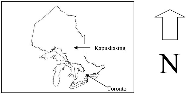
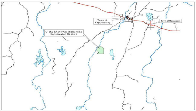
The Shanly Creek Drumlins Conservation Reserve totals 3,500 hectares in size and is located in site district 3E3. The Reserve is 40 km south of the Town of Kapuskasing on the east side of the Kapuskasing River in Shanly Township. The Shanly Creek Drumlins Conservation Reserve is located within the Hearst District in the Northeast Region.
Numerous linear ice flow features ranging from drumloidal ringes to fluted forms are oriented southeast in the proposed conservation reserve. The Cochrane Events Environment was characterized by multiple, relatively short-lived surge events reflecting in part an abundance of meltwater and readily deformable substrate. The Shanly Creek Southeast Fluted Forms site represents glacial activity related to the Cochrane I event near its southern extent. The ice flow forms are associated with overlying glaciolacustrine silty clay, probably representative of Glacial Lake Ojibway, as well as iceberg keel marks. The Shanly Creek Drumlins Conservation Reserve contains some exceptional examples of linear ice flow forms.
Direction for establishing, planning and managing conservation reserves is defined under the Provincial Parks and Conservation Reserves Act (PPCRA) (Statutes of Ontario 2006) and associated regulations and guidelines. The specific direction for managing this conservation reserve is in the form of a basic SCI, which defines the area to which the plan applies, provides the purpose for which the conservation reserve has been proposed, and outlines the Ministry of Natural Resources and Forestry’s (MNRF) management intent for the protected area. It will provide both the foundation for continued monitoring of activities and guidance for managing the conservation reserve. More detailed direction at this time is not anticipated. However, should significant facility development be considered or complex issues arise requiring additional studies, more detailed management direction in the form of special protection measures, or a detailed Resource Management Plan, will be prepared with full public consultation.
The public was informed and consulted prior to the regulation of the Shanly Creek Drumlins Conservation Reserve under the Public Lands Act as well as during the preparation and review of this Statement of Conservation Interest.
The Shanly Creek Drumlins Conservation Reserve will be managed under the jurisdiction of the Hearst District MNRF under the supervision of the Hearst District Manager.
Compiled by:
Patrick Burrough
Recommended for approval by:
R. David Scott Date
District Manager
Hearst District
Original Signed on March 24, 2005
Approved by:
Rob Galloway
Regional Director
Northeast Region
Original Signed on April 10, 2005
Administrative update
Approved by:
Wesley Woods
Hearst District Manager
Date: June 26, 2017
Corrine Nelson
Regional Director
Northeast Region
Date: July 24, 2017
1.0 Introduction
The Province of Ontario is home to a broad range of climate types, geography, and plant and animal species, all of which contribute to the variety and abundance of natural resources found here. The Ministry of Natural Resources and Forestry (MNRF) is the lead conservation and resource management agency in the province and is therefore responsible for the management of these resources, in particular, forests, fisheries, wildlife, mineral aggregates and petroleum resources, Crown lands and waters, and provincial parks and protected areas (MNR 2000).
The MNRF is committed to the protection of natural and cultural heritage values and as such has developed strategies that will maintain the integrity and sustainability of the parks and protected areas system. Recently the Government of Ontario conducted a major land use planning exercise, which resulted in the release of the Ontario’s Living Legacy Land Use Strategy (MNR 1999). The Land Use Strategy (LUS) focuses on four specific objectives that were established to guide the planning process. These are: to complete Ontario’s system of parks and protected areas; to recognize the land use needs of the resource-based tourism industry; to provide forestry, mining, and other resource industries with greater land and resource use certainty; and to enhance hunting, angling and other Crown land recreation opportunities. A major part of the Ontario’s Living Legacy Land Use Strategy was the government’s initiative to establish 378 new protected areas.
The Shanly Creek Drumlins Conservation Reserve (C1702) was created as part of this expansion. As a result, the planning and management of this conservation reserve is consistent with the policies outlined in the Land Use Strategy. This conservation reserve is regulated under the Public Lands Act (PLA). Prior to its regulation, MNRF met the Environmental Assessment Act requirements for the establishment and management of this conservation reserve.
Ontario’s network of natural heritage areas has been established to protect and conserve areas that represent the diversity of the natural regions of the province, including the species, habitats, special features and ecological systems which comprise that natural diversity. Protecting these natural heritage areas is the cornerstone to the sustainable management of natural resources. It ensures that representative sites are retained in their natural state and can continue to contribute to Ontario’s natural environment (MNR 1997a).
In order to preserve these sensitive areas they require protection from incompatible uses to ensure their values will endure over time. Conservation reserves have been identified as a way of providing necessary protection from incompatible uses such as forestry and aggregate extraction, while still permitting many of the traditional uses that allow the people of Ontario to enjoy our special heritage. An approved Statement of Conservation Interest (SCI) or a Resource Management Plan (RMP) will guide the management and administration of each conservation reserve.
The management direction for this conservation reserve is a Statement of Conservation Interest. As a stewardship document, the SCI is the minimum level of management direction established for this conservation reserve. SCIs define the area that is being planned, the purpose for which the conservation reserve has been proposed, and it outlines the Ministry of Natural Resources and Forestry’s intent for the protected area. This SCI will govern the lands and waters within the regulated boundary of the conservation reserve. However, to ensure MNRF protection objectives are being fully met within the conservation reserve, the surrounding landscape and related activities must consider the site’s objectives and heritage values. In addition, it is the intent of this SCI to create public awareness that will promote responsible stewardship of protected areas and surrounding lands. With management partners such as Ontario Parks, industry, local governments, etc. the MNRF District Offices will be able to pursue and advance sound environmental, economic and social strategies and policies related to the protection of conservation reserves and provincial parks.
The purpose of this SCI is to identify and describe the values of the Shanly Creek Drumlins Conservation Reserve and outline the Ministry’s management intent. The management direction will protect the site’s natural heritage values for the benefit of all Ontario residents and demonstrate its compatibility within the larger sustainable landscape. This direction will comply with land use intent as stated by the Ontario’s Living Legacy Lands Use Strategy (MNR 1999).
The Shanly Creek Drumlins Conservation Reserve totals 3,500 hectares in size and is located in site district 3E3. The Reserve is 40 km south of the Town of Kapuskasing on the east side of the Kapuskasing River in Shanly Township. The Shanly Creek Drumlins Conservation Reserve is located within the Hearst District in the Northeast Region.
Numerous linear ice flow features ranging from drumloidal ringes to fluted forms are oriented southeast in the conservation reserve. The Cochrane Events Environment was characterized by multiple, relatively short-lived surge events reflecting in part an abundance of meltwater and readily deformable substrate. The Shanly Creek Southeast Fluted Forms site represents glacial activity related to the Cochrane I event near its southern extent. The ice flow forms are associated with overlying glaciolacustrine silty clay, probably representative of Glacial Lake Ojibway, as well as iceberg keel marks. The conservation reserve contains some exceptional examples of linear ice flow forms.
Conservation reserves complement provincial parks in protecting representative natural areas and special landscapes. The guidelines for the management of this conservation reserve are found in this document.
2.0 Goals and objectives
2.1 Goal of the Statement of Conservation Interest
The goal of a conservation reserve, as stated in Policy PL 3.03.05 (MNR 1997a), is to protect the natural heritage values on public lands while permitting compatible land use activities. The goal of this Statement of Conservation Interest is to provide the framework and direction to guide management decisions in order to ensure the Shanly Creek Drumlins Conservation Reserve will meet this goal through both short and long-term objectives.
2.2 Objectives
2.2.1 Short term objectives
Objective 1: To define the purpose for which the conservation reserve has been identified and to outline the Ontario Ministry of Natural Resources and Forestry’s management intent for the protected area.
Strategies:
- By identifying the state of the resource with respect to the natural heritage values being protected
- By identifying current land use activities that are occurring on the land base
Objective 2: To determine the best management strategy to protect the integrity of the values in the site.
Strategies:
- By determining the land use compatibility of current and potential land uses
- By developing specific guidelines and prescriptions to manage existing and potential land uses
Objective 3: To create public awareness of the values within this conservation reserve and promote responsible stewardship of the protected area.
Strategies:
- Will partner with any local stakeholders who come forward and when active management is necessary to ensure the values of the site are properly protected.
This Statement of Conservation Interest meets the planning requirements for conservation reserves as determined in Procedure PL 3.03.05 which states that management plans must be written within three years of the regulation date (MNR 1997b).
2.2.2 Long term objectives
Objective 1: To determine the long term management goals of the conservation reserve.
Strategies:
- By identifying the research needs necessary to determine the position of this conservation reserve among the system of parks and protected areas in Ontario
Objective 2: To determine the representative targets of the site.
Strategies:
- By identifying any monitoring or research necessary to identify and maintain the integrity of these characteristics beyond this plan
Objective 3: To provide direction for the evaluation of new uses or economic ventures proposed.
Strategies:
- A Protected Area Compatibility Test (Appendix B) shall be undertaken to evaluate the impact of suggested use(s), either positive or negative, on the protected values and administrative needs of the conservation reserve
3.0 Management planning
3.1 Planning context
3.1.1 Planning area
The planning area for this site will consist of the regulated boundary for the Shanly Creek Drumlins Conservation Reserve as defined in section 4.1.3 Administrative Description. This land base will form the area directly influenced by the Statement of Conservation Interest. It is also recognized that the surrounding landscape and related activities must carefully consider the site’s values to ensure that the protection objectives are being fully met within the conservation reserve. The MNRF, in conjunction with other partners, will work to ensure that the values are protected during additional planning and implementation of activities on the intervening landscape. Any strategies noted within this plan related to the site’s boundary or beyond will need to be presented for consideration within a larger planning context.
3.1.2 Management planning context
The Ontario Living Legacy Land Use Strategy (1999) describes the Shanly Creek Drumlins Conservation as containing numerous linear ice flow features from drumlinoidal ridges to fluted forms are oriented in a southeast direction within this site. The ice flow features are overlain by a unit of glaciolacustrine silty clay, probably representative of Glacial Lake Ojibway. A number of well developed iceberg keel marks are present in the north half of the site. The site was then regulated as Schedule 270, in Ontario Regulation 181/05 made under the Public Lands Act, April 20, 2005 and subsequently regulated under the PPCRA (Statutes of Ontario 2006) by Ontario Regulation 315/07 on June 9, 2008.
Once a Conservation Reserve is passed into regulation, it must be determined what level of management planning is required to fulfill the protection targets. This Statement of Conservation Interest will only address known issues or current proposals with respect to permitted uses or potential economic opportunities brought forward during this planning stage. However, in terms of approving future permitted uses and/or development(s), there are established mechanisms in place to address such proposals. Any future proposals will be reviewed using the Protected Area Compatibility Test (Appendix B) and the Class Environmental Assessment for Provincial Parks and Conservation Reserves (OMNR 2005)
Consideration for proposals pertaining to cultural resources may be screened using A Technical Guideline for Cultural Heritage Resources for Projects Planned under the Class Environmental Assessment for MNR Resource Stewardship and Facility Development Projects and the Class Environmental Assessment for Provincial Parks and Conservation Reserves.
These planning tools will help refine the review process once the proposal satisfies the direction and intent of the Public Lands Act, associated policies and this planning document.
3.2 Planning process
There are two policy documents that address the planning process; a Statement of Conservation Interest (SCI) is the minimal requirement for providing planning direction and a Resource Management Plan (RMP) that deals with more complex issues (where several conflicting demands are placed on the resources). The guidelines for the preparation of these documents is outlined in Procedural Guideline A – Resource Management Planning (Conservation Reserves Procedure PL3.03.05 Public Lands Act). The appropriate plan must be completed within three years of the regulation date.
For current planning purposes, the Shanly Creek Drumlins Conservation Reserve will be managed under the auspices of a Statement of Conservation Interest. Interested parties from both the private and public sectors were consulted during the Ontario’s Living Legacy (OLL) planning process from candidate conservation reserve to regulation. The public was consulted during the conservation reserve’s creation and final regulation. The responses and concerns brought forward during that consultation period are reflected in this Statement of Conservation Interest.
Public consultation will be solicited during a review of any future land use proposals that would require new decisions to be made. In addition, any future proposal and/or any new, significant management direction considered will be published on the Environmental Bill of Rights registry (EBR).
The SCI is a policy document that will provide background information, identify values to be protected and establish management guidelines for use in the administration of the reserve.
The implementation of the policy will be the mandate of the MNRF at the district level, however associations with various partners may be sought to assist in the delivery. It must be noted that this SCI is a working document and it will be necessary to make revisions to it from time to time.
As part of public consultation, initial consultation was solicited from the public, First Nation communities, and stakeholders that may have an interest in the conservation reserves in the Hearst District by means of direct mail. Also, newspaper ads were placed in five local papers in Kapuskasing, Hearst, Chapleau, and Timmins that may have an interest in the conservation reserves in the Hearst District. They are listed below:
- LeNord (Hearst)– French
- The Weekender (Hearst/Kapuskasing)– French & English
- Northern Times (Kapuskasing) – English
- Chapleau Express – English
- Timmins Daily Press– English
- Cochrane-English/French
The purpose of the consultation was to notify that the management planning for the six conservation reserves within the Hearst District was beginning and:
- MNRF is collecting comments and information regarding these SCIs to assist in making decisions and determining future public consultation needs
- Respondents will be notified when the draft statements of conservation interest are available for review. At that time a copy of the draft would be provided to interested persons or organizations upon request
The MNRF is exempt from providing notification of this planning process on the Electronic Bulletin Registry, under Section 30 of the Environmental Bill of Rights (EBR).
Note that public consultation will be solicited during a review of any future land use proposals that would require new decisions to be made. In addition, any future proposal and/or any new, significant management direction considered will be published on the Environmental Bill of Rights registry (EBR).
4.0 Background information
4.1 Location and site description
4.1.1 Location
Table 1: Location and administrative details for the Shanly Creek Drumlins Conservation Reserve
| Name | Shanly Creek Drumlins Conservation Reserve |
|---|---|
| Eco- Region Eco-District (Hills 1959) | 3E-3 |
| Eco-Region Eco-District (Crins and Uhlig 2000) | Lake Abitibi 3E Smokey Falls Ecodistrict 3E-1 |
| MNRF Administrative Region/District/Area | Northeast Region/Hearst |
| Size | 3,734 ha |
| Nearest Town | Kapuskasing |
| Townships | Shanly, Concabar |
| UTM Ref. | 375544 |
| Map Name | Woman Falls |
| Latitude/Longitude | 49°05'02"N 81°42'46"W |
| Elevation | Minimum: 250 m Maximum: 260 m |
| Watershed | Moose River Basin |
| Wildlife Management Unit | WMU 24 |
| Forest | Gordon Cosens |
4.1.2 Physical site description
The Shanly Creek Drumlins Conservation Reserve is comprised of 3,734 ha and is located approximately 40 km southwest of Kapuskasing in the townships of Shanly and Concobar.
The Shanly Creek Drumlins Conservation Reserve is found within Site District 3E-3 (Cochrane)(Hills, 1959). However, Crins has redefined the site district boundaries and as a result the conservation reserve is now situated in Ecodistrict 3E-1 (Smokey Falls) (Crins, 2000). The Smokey Falls Ecodistrict is located in the central portion of the Lake Abitibi Ecoregion 3E. The 3E Ecoregion is characterized by moderately to gently rolling bedrock, generally covered by deep deposits of clay, silt and sand. The forest climate for the site is mid-humid, mid-boreal.
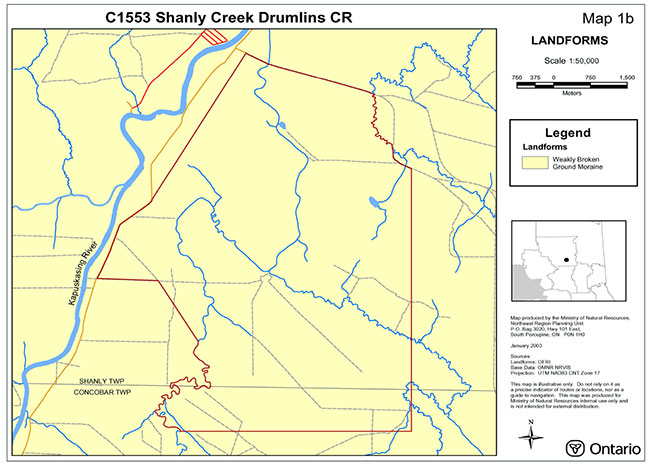
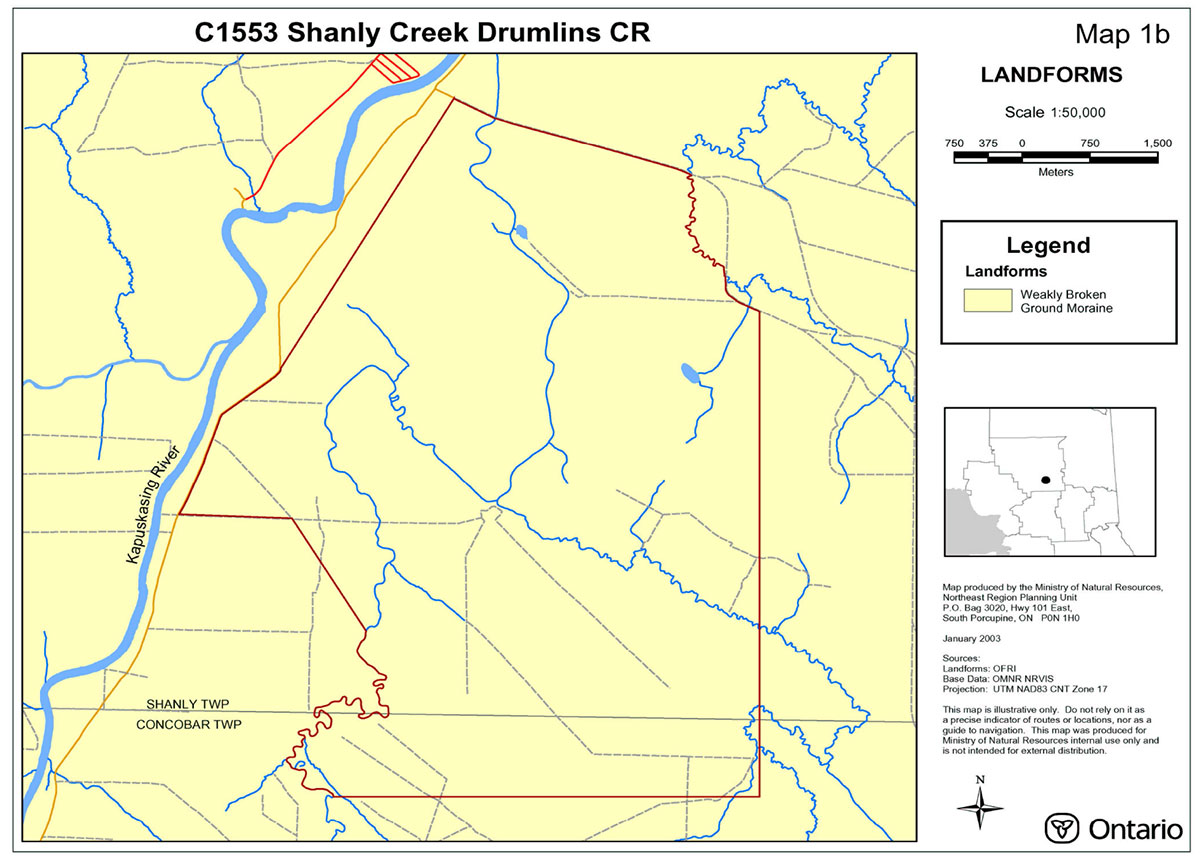
The Shanly Creek Drumlins Conservation Reserve is situated in the Abitibi Uplands Physiographic Region. This area has broad rolling surfaces that are mantled by glacial lake deposits (Bostock, 1970). The provincial landform analysis suggests this site to be entirely composed of weakly broken ground moraine (Map 1b - Landforms).
The Shanly Creek Drumlins falls in the Moose River Basin within the 4LF tertiary watershed. The only real link to aquatics is the creek system, which is linked to Kapuskasing River located west of the site.
This conservation reserve is found in Rowe’s (1972) Northern Clay Boreal Forest Section and is inhabited by black spruce stands, which occupy both the rising uplands and on the lowland flats coexisting with sedge fens and sphagnum-heath bogs. Tamarack (larch) is an occasional companion of the black spruce. Black spruce commonly occurs with cedar in swamp areas mainly in the west, but the cedar are most dominant along the borders of the swamps since this is where they reach tree size. Areas that display examples of shallowly buried coarse drift or that are located in close proximity to lakes and rivers show examples of hardwood or mixed wood communities such as trembling aspen, balsam poplar, balsam fir, white spruce and black spruce. Areas that are drier in nature such as old beaches, eskers, and outwash deposits exhibit stands of jack pine and white birch are found on sandy soils (Rowe, 1972).
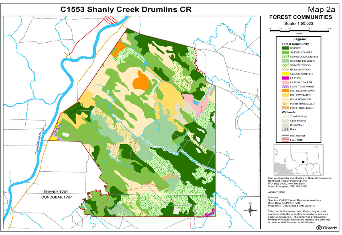
The FRI data for this conservation reserve shows a strong presence of both black spruce and poplar forest communities, which together occupy almost the entire area of the site. Black spruce inhabits approximately 70 percent of the conservation reserve’s total area as dominant conifer
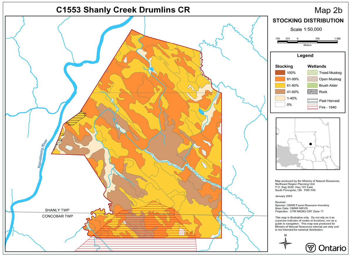
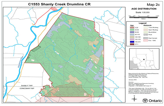
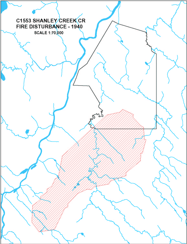
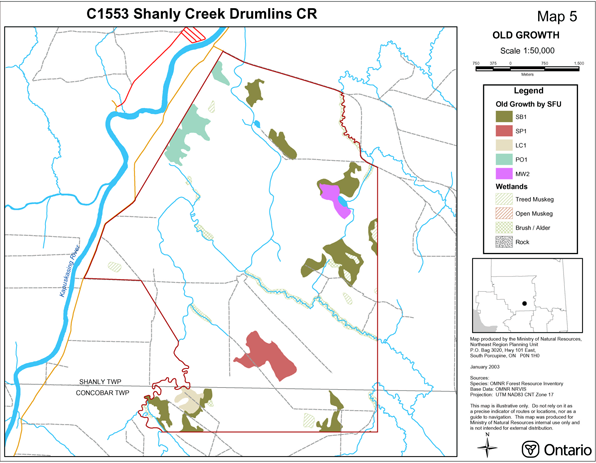
Stocking for this site is quite uneven and ranges from 1-40 percent up to 81-99 percent (Map 2b – Stocking). The sites age distribution on the other hand is fairly even with the majority of the forest stands within the site aged between 30-59 years (Map 2c – Age Distribution). The site does contain a small number of old growth stands, which are aged between 90-119 years, which included poplar and 120-149 years, which largely consisted of black spruce (Map 2c – Age Distribution) and Map 5 – Old Growth). Approximately 65 years ago the site was significantly disturbed possibly by fire which resulted in many of the black spruce and poplar dominated stands to contain 65 to 68 year old trees and little old growth representation on the site (Map 5 – Old Growth). It is expected that the majority of black spruce will achieve maturity in approximately 15 years and attain old growth in approximately 55 years. Similarly, the poplar dominated stands have reached maturity and will start to show signs of old growth in approximately 25 years.
4.2 Administrative description
The legal description of the Shanly Creek Drumlins Conservation Reserve, regulated as Schedule 270 in Ontario Regulation 181/05 made under the Public Lands Act on April 20, 2005 and filed on April 21, 2005 amending Ontario Regulation 805/94.
The Shanly Creek Drumlins Conservation Reserve is located within the MNRF, Hearst District administrative area and within the legal boundaries of the Gordon Cosens Forest Sustainable Forest License area.
4.3 History of the site
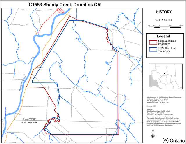
Approximately 65 years ago the site was significantly disturbed possibly by fire which resulted in many of the black spruce and poplar dominated stands to contain 65 to 68 year old trees and little old growth representation on the site (Map 5 – Old Growth).
There was also extensive historical disturbance as a result of horse logging with the horse trails still visible, however time and probably minimal compaction of soils has resulted in a continuous forest. There is a more recent harvest along the western boundary of the site which is regenerating into black spruce but the trees observed were small and are facing heavy competition from deciduous growth with alder being the major competing species (Thompson, 2001). An old road makes up the site’s northern boundary with a secondary road making up a portion of the western boundary.
4.4 Inventories
Table 2 indicates the current status of natural heritage inventory that has occurred or that will be required in the near future.
Table 2: Inventory and survey information for Shanly Creek Drumlins Conservation Reserve
| Survey level | Earth Science | Life Science | Cultural | Recreational | Other |
|---|---|---|---|---|---|
| Reconnaissance | 2001 (Kor) Aerial Photo Interpretation | 2002 (Thompson) Aerial Survey | 2002 (Malenfant and Thompson) Aerial Survey | ||
| Detailed | |||||
| Further requirements | Aerial reconnaissance survey | Life Science Gap Analysis |
5.0 State of the resource
Representation
The Shanly Creek Drumlins Conservation Reserve is comprised of 3734 ha and is located approximately 40 km southwest of Kapuskasing in the townships of Shanly and Concobar. Access to the site is fair with a secondary road following a portion of the sites western boundary and some old logging roads and trails running through the interior of the site. The site is highly vectored with only a minimal presence of biological and cultural boundaries. The Shanly Creek Drumlins Conservation Reserve was originally an Earth Science Gap Site (GAP Shanly Creek) and was brought forward in option (E71) during the Lands for Life Option Development Workshop (Houle and Thompson, 1999).
The Shanly Creek Drumlins Conservation Reserve is found within Site District 3E-3 (Cochrane)(Hills, 1959). However, Crins has redefined the site district boundaries and as a result the conservation reserve is now situated in Ecodistrict 3E-1 (Smokey Falls) (Crins, 2000). The Smokey Falls Ecodistrict is located in the central portion of the Lake Abitibi Ecoregion 3E. The 3E Ecoregion is characterized by moderately to gently rolling bedrock, generally covered by deep deposits of clay, silt and sand. The forest climate for the site is mid-humid, mid-boreal. Currently the only ecodistrict descriptions available are those documented by Poser (1992) based on Hills site district boundaries. Therefore a description of the current 3E-1 Smokey Falls Ecodistrict may require some modifications. The Smokey Falls Ecodistrict is characterized by a smooth plain of clay and loam, moderate to high in lime, shallow to moderately deep over bedrock with a fairly high percentage of muskeg. The Cochrane Site District is described as having a plain of very high to moderate lime clay and silt covered by peat six inches or more in depth over most of the area. The vegetation of the area is commonly found on esker and rock ridges (Hills, 1959; Poser, 1992).
The Shanly Creek Drumlins Conservation Reserve is situated in the Abitibi Uplands Physiographic Region. This area has broad rolling surfaces that are mantled by glacial lake deposits (Bostock, 1970). The provincial landform analysis suggests this site to be entirely composed of weakly broken ground moraine (Map 1b – Landforms). When referring to the earth science checksheet for Shanly Creek Drumlins Conservation Reserve, at its original size of 3400 ha, it is apparent that this site consists of linear ice flow features ranging from drumlinoidal ridges to fluted forms, which are oriented in a southeast direction. A unit of glaciolacustrine silty clay overlies these ice flow features. Furthermore, there are well-developed iceberg keel marks located in the northern half of the site and organic material likely overlies the glaciolacustrine deposits in the low-lying areas between the ice flow forms (Kor and Kristjansson, 1997).
This conservation reserve is found in Rowe’s (1972) Northern Clay Boreal Forest Section and is inhabited by black spruce stands, which occupy both the rising uplands and on the lowland flats coexisting with sedge fens and sphagnum-heath bogs. Tamarack is an occasional companion of the black spruce. Black spruce commonly occurs with cedar in swamp areas mainly in the west, but the cedar is most dominant along the borders of the swamps since this is where they reach tree size. Areas that display examples of shallowly buried coarse drift or that are located in close proximity to lakes and rivers show examples of hardwood or mixed wood communities such as trembling aspen, balsam poplar, balsam fir, white spruce and black spruce. Areas that are drier in nature such as old beaches, eskers, and outwash deposits exhibit stands of jack pine and white birch are found on sandy soils (Rowe, 1972).
The FRI data for this conservation reserve shows a strong presence of both black spruce and poplar forest communities, which together occupy almost the entire area of the site. Black spruce inhabits approximately 70 percent of the conservation reserve’s total area as dominant conifer
Stocking for this site is quite uneven and ranges from 1-40 percent up to 81-99 percent (Map 2b – Stocking Distribution). The sites age distribution on the other hand is fairly even with the majority of the forest stands within the site aged between 30-59 years (Map 2c – Age Distribution). The site does contain a small number of old growth stands, which are aged between 90-119 years, which included poplar and 120-149 years, which largely consisted of black spruce (Map 2c – Age Distribution and Map 5 – Old Growth). Approximately 65 years ago the site was significantly disturbed possibly by fire which resulted in many of the black spruce and poplar dominated stands to contain 65 to 68 year old trees and little old growth representation on the site (Map 5 – Old Growth). It is expected that the majority of black spruce will achieve maturity in approximately 15 years and attain old growth in approximately 55 years. Similarly, the poplar dominated stands have reached maturity and will start to show signs of old growth in approximately 25 years.
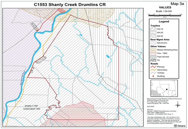
Wildlife values for this site include one bear management area, two traplines and two baitfish blocks (KA-36-03) (KA-10-41).
Wetland
Quality of present representation
a) Diversity
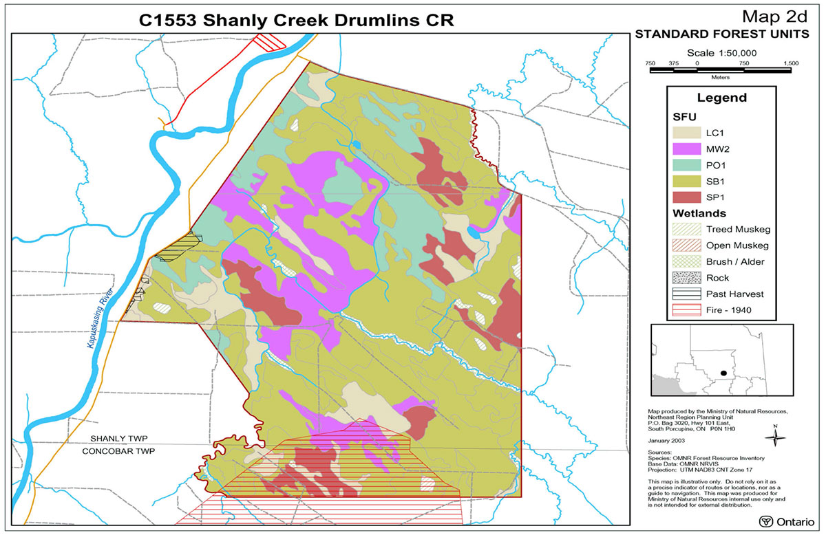
Diversity is a measure of the site’s life and earth science heterogeneity. It is based on the number and range (variety) of the natural landscape features and landforms for earth science values and the richness and evenness of the life science components. This site was originally captured as an earth science site (MNR 1999), therefore the life science values have not been evaluated within the context of Ecodistrict 3E-1. When reviewing the forest communities map (Map 2a), it is apparent that the site’s forest stands are well dispersed throughout the conservation reserve. However, the site’s evenness is skewed towards two major forest communities resulting in an overall low diversity rating for this conservation reserve. This skewed diversity is further exhibited by the ecological grouping of FRI into Standard Forest Units (SFU) (Map 2d), which clearly shows the dominant presence of black spruce (Lowland Black Spruce (SB1) and Spruce Pine
It is expected that diversity would have been slightly increased if developmental stages
b) Ecological factors
Wherever possible, a site’s boundaries should be created to include the greatest diversity of life and earth science features to provide the maximum ecological integrity. It should be ecologically self-contained, bounded by natural features and include adequate area to buffer the core ecosystems from adjacent land use activities (OMNR, 1992). The site contains a large number of vectored boundaries with a minor presence of cultural and biological boundaries. The northern part of the site follows an old logging road and a portion of the western boundary follows a secondary road making up the cultural boundaries for the site. Biological boundaries follow the centerline of creeks in the northeastern and southwestern corners of the site. Some of the forest communities within this conservation reserve are segmented by the presence of straight-line boundaries; however the majority of these stands are fairly large and therefore still maintain good core areas and contribute significantly to the features present within the site. The cedar dominant conifer and pure tamarack (larch) communities occur at less than 10 ha in size and are severed by vectored boundaries in the west and southeast respectively. However, both these communities would be classified as cooler than normal sites on moist to wet soils and as such could contribute to the value of the site as communities fewer than 10 ha in size. The contribution of the cedar communities (cedar swamp communities) is somewhat questionable since it is further fractured into two identities and not specifically related to a landform or other feature. The larch community contributes somewhat to the values of the site, since it is associated with the banks of Concobar Creek. In summary the contribution of both communities is minimal at best.
Currently we do not have minimum size standards for conservation reserves under different landscape conditions. However, a minimum size standard of 2000 ha has been established for natural environment parks by Ontario Parks (OMNR, 1992). This minimum standard was considered necessary to protect representative landscapes as well as allow for low intensity recreational activities. The Shanly Creek Drumlins Conservation Reserve is 3734 ha in size and therefore meets this minimum standard. However, the lack of on site lakes may decrease the recreational potential of the site.
c) Condition
Overall the condition of the site is considered to be good. There was extensive historical disturbance as a result of horse logging with the horse trails still visible, however time and probably minimal compaction of soils has resulted in a continuous forest. There is a more recent harvest along the western boundary of the site which is regenerating into black spruce but the trees observed were small and are facing heavy competition from deciduous growth with alder being the major competing species (Thompson, 2001). An old road makes up the site’s northern boundary with a secondary road making up a portion of the western boundary. Future inventory and assessment of access routes within and bordering the site is warranted.
d) Special features
The special features of the site include provincially significant earth science features including ice flow forms and iceberg keel marks (Kor and Kristjansson, 1997). This site has been disturbed by horse logging, which adds to its cultural features. Furthermore, the majority of black spruce and poplar communities are approximately 65 years old, which may be the result of a historic fire. Such an extensive disturbance resulted in many even aged stands and little old growth.
e) Current land use activities
Current land use activities within or near the conservation reserve, trapping, snowmobiling, fishing, hunting, canoeing, and kayaking. The Kapuskasing River is located west of the site running parallel to the site’s western boundary. A number of factors will serve to restrict the amount of people that will use the conservation reserve and include the limited road access, lack of a trail system (snowmobile/ATV).
Few lakes are present within the conservation reserve, which is typical of the Claybelt (Rowe 1972) and is likely to decrease the recreational potential of the site. Wildlife values for this site include one bear management area, two traplines and two baitfish blocks (KA-36-03) (KA-10-41).
5.1 Social/economic interest in the area
a) Linkage to local communities
The Shanly Creek Drumlins Conservation Reserve is approximately 40 km southwest of Kapuskasing. It is anticipated that the impact of human recreational activities within the conservation reserve should be minimal because of limited road access and lack of a trail system. Also, the lack of on site lakes may decrease the recreational potential of the site. The only real link to aquatics is the creek system, which is linked to Kapuskasing River located west of the site.
Some of the other recreational/commercial activities that the Shanly Creek Drumlins Conservation Reserve represents may include wildlife viewing, photography, fishing, hunting. Hunting, trapping and fishing are long-standing traditional activities and they are also a vital part of the local economy. Economic benefits are seen at local establishments from bear and moose hunting parties as well as fishing enthusiasts, and trapping provides a source of income to local trapline holders.
b) Heritage estate contributions
There are no life science values reported for this site since it was captured during OLL as an earth science site therefore the site’s significance is currently unknown. However, the site does contain provincially significant earth science features including ice flow forms and iceberg keel marks (Kor and Kristjansson, 1997). A life science gap analysis is required to place its life science feature and significance within Ecodistrict 3E-1.
c) First Nations
The Shanly Creek Drumlins Conservation Reserve lies within the of Nishnawbe-Aski Nation (N.A.N) Treaty # 9 Area. The protection of this area as a conservation reserve and the Statement of Conservation Interest are not meant to infringe on the Treaty and Aboriginal Rights of any First Nation in any way. Traditional uses such as hunting, fishing, trapping and gathering will be respected. At the present time, there are no known land claims by First Nations for the area in question.
d) Mining interests
This conservation reserve has no mining tenure within it. Mining and surface rights have been withdrawn from staking within the conservation reserve boundaries under the Mining Act (RSO 1990 Chapter M.14). Mining will not occur in any regulated protected area.
e) Forest and fire management history
The MNRF recognizes fire as an essential process fundamental to the ecological integrity of conservation reserves. Fire Protection will be carried out in accordance with The Wildland Fire Management Strategy (2014), which provides direction for how the MNRF manages wildland fire across Ontario.
Whenever feasible, the MNRF fire program will endeavour to use "light on the land" techniques, which do not unduly disturb the landscape, in this conservation reserve. Examples of light on the land techniques may include limiting the use of heavy equipment or limiting the number of trees felled during fire response efforts. Opportunities for prescribed burning to achieve ecological or resource management objectives may be considered. These management objectives will be developed with public consultation prior to any prescribed burning, and reflected in the document that provides management direction for this conservation reserve. Plans for any prescribed burning will be developed in accordance with the Wildland Fire Management Strategy (2014), and the Class Environmental Assessment for Provincial Parks and Conservation Reserves.
f) Other government agencies, departments or crown corporations
Other Government Agencies that may have an interest in the site include the Ministry of Tourism, Culture, and Sport (MTCS). Although there are no known cultural heritage values present at this time if values were identified in the site the MNRF would work with the MTCS to ensure proper protection of any cultural heritage resources. The MNRF will also work in conjunction with the MTCS to identify/enhance any potential tourism opportunities, in particular where resource-based tourism (RBT) potential is identified. RBT operations include hunting and fishing as well as eco-tourism opportunities. Proper evaluation will be undertaken where opportunities are identified to ensure consistency with the management policies of this conservation reserve.
5.2 Natural Heritage Stewardship
There are no life science values reported for this site since it was captured during OLL as an earth science site therefore the site’s significance is currently unknown. However, the site does contain provincially significant earth science features including ice flow forms and iceberg keel marks (Kor and Kristjansson, 1997). A life science gap analysis is required to place its life science feature and significance within Ecodistrict 3E-1.
5.3 Fisheries and wildlife
Wildlife values for this site include one bear management area, two traplines and two baitfish blocks (KA-36-03) (KA-10-41)(Values - Map 3a).
It is not known if any vulnerable, threatened or endangered species exist on or near the site. Further detailed habitat studies may be warranted.
5.4 Cultural Heritage Stewardship
There are no known cultural heritage values within the Shanly Creek Drumlins Conservation Reserve and no detailed research has been conducted as of this date to document possible cultural heritage values. If archaeological/cultural resources are discovered within the conservation reserve proposals pertaining to the development/use of these cultural resources may be screened through direction provided in A Technical Guideline for Cultural Heritage Resources for Projects Planned under the Class Environmental Assessment for MNR Resource Stewardship and Facility Development Projects and the Class Environmental Assessment for Provincial Parks and Conservation Reserves.
5.5 Land use/current or past development
This conservation reserve rest entirely on Crown land and is unencumbered by any land use permits, licences of occupations, leases or mining claims. There is no mining tenure near the site and no mines have been developed on the site in the past.
5.6 Commercial use
This site includes one bear management area, two traplines and two baitfish blocks.
5.7 Tourism/recreational use/opportunities
The impact of human recreational activities within the bounds of the conservation reserve is also anticipated to have a minimal impact on the site’s ability to maintain its core values over the long-term. Recreational activities will likely be restricted to remote wilderness and backcountry travel with canoeing or kayaking the most probable form of transportation.
5.8 Client services
Currently visitor services at the MNRF Kapuskasing Area Office, Hearst District Office are limited to responding to inquiries about access, natural heritage features and boundaries. No formal information or interpretive facilities currently exist within the conservation reserve.
6.0 Management guidelines
6.1 Management planning strategies
The land use intent outlined in the OLL Land Use Strategy (MNR 1999) provides context and direction to land use, resource management, and operational planning activities on Crown land. Commitments identified in the above strategy and current legislation (Policy 3.03.05 PLA) will form the basis for land use within Shanly Creek Drumlins Conservation Reserve. Management strategies for these uses must consider the short and long-term objectives for the reserve. For up to date information on permitted uses refer to the Crown Land Use Atlas.
Protected areas will be managed to retain and/or restore natural features, processes and systems. They will also provide opportunities for compatible research, education and outdoor recreation activities (MNR 1997c). Proposed uses and development will be reviewed on a case-by-case basis. A Protected Area Compatibility Test (Appendix B), (Procedural Guidelines B – Land Uses PL 3.03.05) must be passed before they are deemed acceptable. The emphasis will be on ensuring that the natural values of the conservation reserve are not negatively affected by current and future activities. Therefore any application for new specific uses will be carefully studied and reviewed via the above environmental screening process.
Management strategies will also be consistent with the objectives of promoting responsible stewardship and identifying inventory, monitoring, and research opportunities.
6.2 "State of the resource" management strategies
The development of this SCI and the long-term management and protection will be under the direction of the MNRF's Hearst District. The following section will deal with the management strategies that are specifically laid out to maintain, protect and enhance the existing natural heritage values and land use activities of the Shanly Creek Drumlins Conservation Reserve.
Natural heritage values
The management intent for the Shanly Creek Drumlins Conservation Reserve will be to allow for natural ecosystems, processes and features to operate undisturbed with minimal human interference while providing educational, research and recreational activities.
Forest fire protection will be provided as per fire strategies used on surrounding public lands, under the direction of the Wildland Fire Management Strategy (2014). All wildfire occurrences will be considered a high priority and will actively be suppressed. Prescribed burning will be conducted only under the direction of the Wildland Fire Management Strategy (2014). Prescribed burning may be utilized if deemed necessary to emulate natural disturbances and renew forest communities, prepare seed beds for research and/or education purposes or to meet additional objectives determined within a separate vegetative management plan.
Defining compatible uses, enforcing regulations and monitoring and mitigating issues will protect all earth and life science features. Industrial activities such as commercial timber harvest and new hydro generation will not be permitted within the conservation reserve. Extraction of unconsolidated sand, gravel, soils or peat is not permitted. Energy transmission, communication and transportation corridors or construction of facilities are discouraged within the boundaries of the conservation reserve. Such structures negatively impact on the quality of representation features that require protection. Alternatives should be reviewed via larger landscape planning processes. New roads for resource extraction and/or private use will not be permitted. Other activities that do not pass a Protected Area Compatibility Test (Appendix B) will be prohibited (MNR 1997a).
The introduction of exotic and/or invasive species will not be permitted. Programs may be developed to control forest insects and diseases where there is a concern that significant values may be compromised. Remedies must focus on the outbreak or infestation. Native biological or non-intrusive solutions should be applied whenever possible.
The collection/removal of vegetation and parts thereof may be permitted subject to a Protected Area Compatibility Test (Appendix B), the District Manager may authorize such activities for purposes of wild rice harvesting, food harvesting, removing exotic species, rehabilitating degraded sites within the reserve, collecting seeds for maintaining genetic stock and/or for inventory or research. The cutting of trees for non-commercial purposes (e.g. fuel-wood) is not permitted.
MNRF will provide leadership and direction for maintaining the integrity of this site as a heritage estate. To ensure MNRF protection objectives are being fully met within the conservation reserve, activities on the surrounding landscape should consider the site’s objectives, heritage values and the design flaws currently present. MNRF via input and plan review will ensure the conservation reserve’s values are considered in local and adjacent land use strategies and plans. Research, education and interpretation will be encouraged to provide a better understanding of the management and protection of the natural heritage values.
Fisheries and wildlife
Sport fishing and hunting will be permitted within this conservation reserve. Fishery and wildlife resources will continue to be managed in accordance with specific policies and regulations defined by the MNRF under the Fish and Wildlife Conservation Act and the Hearst District Manager. Management of these resources will have consideration for the earth and life science features contained within the site.
Cultural heritage values
It is not known if cultural heritage values exist in the Shanly Creek Drumlins Conservation Reserve, however, if values are confirmed management would be consistent with A Technical Guideline for Cultural Heritage Resources for Projects Planned under the Class Environmental Assessment for MNR Resource Stewardship and Facility Development Projects and the Class Environmental Assessment for Provincial Parks and Conservation Reserves.
Land use/past and existing development
The sale of lands within the conservation reserve is not permitted. No new recreational camps will be permitted. Road realignments, telecommunications and other resource networks will be discouraged from crossing the site and interrupting the conservation reserve’s natural state. New roads for resource extraction and/or private use will not be permitted.
Through the Ministry’s plan input and review program, applications for more intense use will be reviewed to ensure natural heritage values within the conservation reserve are considered and protected in planning decisions on adjacent private land.
Any new developments (e.g. tourism developments) proposed for the conservation reserve must go through a Protected Area Compatibility Test (Appendix B) to ensure that the activity is permitted and to ensure the natural heritage values within the site are protected. If a proposal is considered, public consultation may be required. If accepted, an amendment of the SCI would be required.
Social/economic interest
The conservation reserve’s relative remoteness and lack of current uses established within the site may help ensure that its fragile vegetative communities, as well as provincially significant earth and life science features. Future managers will have to balance the need to maintain the quality of the current representation and the needs of current or future users.
Commercial activities
Commercial, non-industrial activities such as fur harvesting, baitfish harvesting and Bear Management Areas will be managed according to prescriptions in the Land Use Strategy (MNR 1999). Fur harvesting traplines and bait fishing operations will be permitted to continue since there are no demonstrated conflicts between these activities and the values being protected. New operations would be subjected to a Protected Area Compatibility Test (Appendix B) to ensure that the wildlife populations could sustain additional activity. Existing Bear Management Areas (BMAs) will be permitted to continue, however, new operations will not be permitted. MNRF managers will work with operators to ensure that the natural heritage values within the conservation reserve are respected.
Aboriginal interests
Traditional activities and aboriginal rights as defined in the Nishnawbe-Aski Nation (N.A.N) Treaty # 9 Area and other relevant Acts will not be affected within the boundaries of this conservation reserve.
Tourism and recreation
The earth and life science features and their protection shall be the overall theme for tourism and recreation within the conservation reserve.
Future economic or development proposals should go through a Protected Area Compatibility Test (Appendix B) to ensure the natural heritage features are well protected. Future trail development must consider the values found within the boundaries of the site, the rationale for developing trails within the site and the availability of current access through the site and surrounding areas. Furthermore, any new trail development will require a 'Protected Area Compatibility Test (Appendix B)'. Sensitive areas previously discussed should be avoided.
Client services
Under the direction of the District Manager, Hearst District staff will respond to public, non-government organizations (NGOs), industry and MNRF partner requests for basic information on the site. Such requests could include but are not limited to the following; regulated boundaries, values, current access and infrastructure, permitted uses, role that Shanly Creek Drumlins Conservation Reserve plays as a natural heritage estate and within the greater provincial parks and protected area system and any additional information that is required to meet good customer service.
6.3 Promote inventory monitoring and assessment reporting and research
Scientific research by qualified individuals or institutions, which contributes to the knowledge of natural and cultural history and to environmental and recreational management, will be encouraged. Research programs will be subject to ministry policies and other legislation.
Approved research activities and facilities will be compatible with the protection objective. Any inventory, monitoring, assessment reporting or research developments or facilities will not be considered until a Protected Area Compatibility Test (Appendix B) is conducted and proposal is approved by the District Manager, Hearst District.
To advance conservation reserve custodial management, future managers will need to monitor the current state of the conservation reserves resources at least at the community and landscape levels within and adjacent to the conservation reserve and its surrounding environment. Such monitoring could include: evaluating and reporting on changes such as; natural disturbances (i.e. fire, insect/disease, wind throw, etc.), human disturbances (i.e. forest harvesting, access and/or other land use activities) as well as management prescriptions (i.e. rehabilitation efforts and/or vegetative management planning).
Ongoing evaluations and reports will have to rely on current and new technologies such as satellite imagery, global positioning systems (GPS), supplementary aerial photography (SAP) and/or aerial/ground reconnaissance surveys/assessments conducted periodically and placed within a GIS database. Such tools could help managers spatially record affected areas, severity of perturbations or management action as well as consider the sensitivity of values, the design of the CR and determine the future desired condition of the site. Monitoring efficiencies could be enhanced via partnerships and internal coordination within MNRF.
6.4 Implementation and plan review
Implementation of this SCI will primarily involve monitoring activities to ensure adherence to the management guidelines. Other activities may include funding future life and earth science inventories and responding to inquiries about the site.
Implementation of the SCI and management of the reserve are the responsibility of the District Manager. Partnership may be pursued to address management needs. Shanly Creek Drumlins Conservation Reserve SCI will be examined, as per the schedule outlined in the PPCRA (Statutes of Ontario 2006). If changes in management direction are needed at any time, the significance of the changes will be evaluated. Administrative updates to the SCI may be considered and approved by the Hearst District Manager and Regional Director without further consultation. In assessing amendments, public and Indigenous consultation will occur. All updates and amendments will follow the process outlined in the Protected Areas Planning Manual (OMNR 2014)
6.5 Marketing
No active marketing of this conservation reserve is anticipated.
7.0 References
Arnup, R., G.D. Racey and R.E. Whaley. 1999. Training manual for photo interpretation of ecosites in northwestern Ontario. NWST Technical Manual TM-003.127p.
Bostock, H.S., 1970. Geology and economic minerals of Canada – Part A
Bridge, S., R. Watt, G. Lucking and B. Naylor. 2000. Landscape analysis for forest management planningin boreal northeastern Ontario. OMNR, Northeast Science and Technology. 36p.
Crins, W.J., 2000. Ecoregions of Ontario: Modifications to Angus Hills' Site Region and Site Districts-Revisions and Rationale.
Kor, P. and R. Kristjansson, 1997. Conservation Geology of Selected Sites in Northeastern Ontario.
Hills, G.A., 1959. A Ready Reference to the Description of the Land of Ontario and its Productivity.
Houle, N. and J. Thompson, 1999. Ontario’s living legacy boundary determination exercise – visits to Hearst District.
OMNR. Ontario Provincial Parks: Planning and Management Policies – 1992 Update
OMNR. 1999. Ontario’s Living Legacy Land Use Strategy, Queen’s Printer for Ontario, Toronto, ON. 136p.
OMNR, 2005. A Class Environmental Assessment for Provincial Parks and Conservation Reserves. Queen’s Printer for Ontario. Ontario. 120pp.
OMNR. 2006. A Technical Guideline for Cultural Heritage Resources for Projects Planned Under the Class Environmental Assessment for MNR Resource Stewardship and Facility Development Projects and the Class Environmental Assessment for Provincial Parks and Conservation Reserves. 45pp.
OMNR, 2014. Ontario’s Protected Areas Planning Manual. Queen’s Printer for Ontario. Peterborough, Ontario. 33pp.
Poser, S., 1992. Report on the Status of Provincial Parks in the Site Regions and Districts of Ontario.Ministry of Natural Resources Report.
Rowe, J.S., 1972. Forest Regions of Canada
Statutes of Ontario, 2006. Provincial Parks and Conservation Reserves Act. S.O. 2006, Chapter 12
Thompson, J.E., 2002. Aerial Reconnaissance Notes
Taylor, K.C., R.W. Arnup, B.G. Merchant, W.J. Parton and J. Nieppola. 2000. A field guide to forestecosystems of northeastern Ontario. 2nd Edition. Northeast Science and Technology NEST Field Guide FG-001.
Uhlig, P., A. Harris, G. Craig, C. Bowling, B. Chambers, B. Naylor and G. Beemer. 2001. Old growthforest definitions for Ontario. Ont. Ministry of Natural Resources and Forestry, Queen’s Printer for Ontario, Toronto. ON. 27p.
8.0 Maps
Map 1: Inset of Ontario showing location of Kapuskasing
Map 1-Large: Location of Shanly Creek Drumlins Conservation Reserve in relation to Kapuskasing
Map 1b - Landforms
Map 2a – Forest communities

Enlarge Map 2a – Forest Communities
Map 2b - Stocking

Map 2c – Age distribution
Enlarge Map 2c – Age Distribution
Map 2d – Standard forest unit
Enlarge Map 2d – Standard Forest Unit
Map 3a – Values
Map 4 – Fire
Map 5 – Old Growth
Map 6 – History
9.0 Appendices
Appendix A: Permitted uses table
Permitted uses table for conservation reserves as per policy
Recreation
| Activities | Conservation reserve policy - permitted? - existing | Conservation reserve policy - permitted? - new | Policy clarification |
|---|---|---|---|
| Sport fishing | Yes | Yes | |
| Sport hunting | Yes | Yes | |
| Food gathering | Yes | Yes | |
| Facility infrastructure | Maybe | Maybe | Any new facilities are subject to a “Protected Area Compatibility Test (Appendix B)” and approval by the District Manager. |
| Rock climbing | Maybe | Maybe | Rock climbing and/or caving is permitted where it does not detrimentally affect the values to be protected. |
| Canoeing/kayaking | Yes | Yes | |
| Motorized boating | Yes | Yes | |
| Picnicking | Yes | Yes | |
| Camping | Maybe | Maybe | Camping is permitted where it does not detrimentally affect the values to be protected. |
Trails
| Activities | Conservation Reserve policy - permitted? - existing | Conservation Reserve policy - permitted? - new | Policy clarification |
|---|---|---|---|
| Hiking trails | Yes | Maybe | Any new hiking trails will be subject to a “Protected Area Compatibility Test (Appendix B)” and approval by the District Manager. |
| Cross-country skiing trails | Yes | Maybe | Any new cross-country skiing trails are subject to a “Protected Area Compatibility Test (Appendix B)” and approval by the District Manager. |
| Cycling/mountain biking trails | Yes | Maybe | Any new cycling trails are subject to a “Protected Area Compatibility Test (Appendix B)” and Approval by the District Manager. |
| Horse riding trails | Yes | Maybe | Any new horse riding trails are subject to a “Protected Area Compatibility Test (Appendix B)” and approval by the District Manager. |
| Snowmobiling trails | Yes | Maybe | Any new snowmobiling trails are subject to a “Protected Area Compatibility Test (Appendix B)” and approval by the District Manager. |
| Non-trail snowmobiling | Maybe | Maybe | Non-trail snowmobiling is only permitted for the retrieval of game. |
| ATV trails | Yes | Maybe | Any new ATV trails are subject to a “Protected Area Compatibility Test (Appendix B)” and approval by the District Manager. |
| Non-trail ATV use | Maybe | Maybe | Non-trail ATV use is only permitted for the retrieval of game. |
Science, education and heritage appreciation
| Activities | Conservation Reserve policy - permitted? - existing | Conservation Reserve policy - permitted? - new | Policy clarification |
|---|---|---|---|
| Research | Yes | Yes | |
| General walking | Yes | Yes | |
| Photography and painting | Yes | Yes | |
| Wildlife viewing | Yes | Yes | |
| Outdoor education/interpretation | Yes | Yes | |
| Collecting | No | No | Collecting may be permitted as part of an authorized research project. The issuance of permits will be considered on a per-site basis. |
Commercial activities
| Activities | Conservation Reserve policy - permitted? - existing | Conservation Reserve policy - permitted? - new | Policy clarification |
|---|---|---|---|
| Food harvesting | Maybe | Maybe | Any new food harvesting is subject to a “Protected Area Compatibility Test (Appendix B)” and approval by the District Manager. |
| Fishing | Yes | Maybe | Any new commercial fishing is subject to a “Protected Area Compatibility Test (Appendix B)” and approval by the District Manager. |
| Baitfish harvesting | Yes | Maybe |
Any new baitfish harvesting operations are subject to a “Protected Area Compatibility Test (Appendix B)” and approval by the District Manager. Transfer requests for existing baitfish operations will be considered on an on-going basis subject to a review of potential impacts. |
| Trapping | Yes | Maybe |
Any new traplines are subject to a “Protected Area Compatibility Test (Appendix B)” and approval by the District Manager. Transfer requests for existing traplines will be considered on an on-going basis subject to a review of potential impacts. |
| Trap cabins | Yes | No | |
| Resort – outpost camps | Yes | Maybe |
Any new outpost camps/resorts are subject to a “Protected Area Compatibility Test (Appendix B)” and approval by the District Manager. Transfer requests for existing outpost camps/resorts will be considered on an on-going basis subject to a review of potential impacts. |
| Outifitting – bear management | Yes | No | Transfer requests for existing Bear Management Areas will be considered on an on-going basis subject to a review of potential impacts. |
| Wild rice harvesting | Yes | Maybe | Any new wild rice operations will be subject to a “Protected Area Compatibility Test (Appendix B)” and approval by the District Manager. |
Resource management
| Activities | Conservation Reserve policy - permitted? - existing | Conservation Reserve policy - permitted? - new | Policy clarification |
|---|---|---|---|
| Inventory/monitoring | Yes | Yes | |
| Featured species management | Maybe | Maybe | Any new featured species management is subject to a “Protected Area Compatibility Test (Appendix B)” and approval by the District Manager. |
| Natural systems management | Maybe | Maybe | Any new natural systems management will be subject to a “Protected Area Compatibility Test (Appendix B)” and approval by the District Manager. |
Industrial activities
| Activities | Conservation Reserve policy - permitted? - existing | Conservation Reserve policy - permitted? - new | Policy clarification |
|---|---|---|---|
| Timber harvesting | No | No | |
| Mineral exploration | No | No | |
| Mining | No | No | |
| Hydro power generation | No | No | |
| Energy transmission corridors/communication corridors | Yes | No | New communication lines and transmission corridors are discouraged from within conservation reserves but can be considered under unusual circumstances where there are no other viable alternatives and where the line/corridor does not significantly impact the values the site is trying to protect. Approval from the District Manager is required. |
| Transport corridors | Yes | No | |
| Resource access roads | Yes | No | Existing roads can continue to be used. Continued use will include maintenance and may include future upgrading. New roads for resource extraction will not be permitted, with the exception of necessary access to existing forest reserves for mineral exploration and development. |
| Private access roads | Yes | No | |
| Fuelwood cutting | No | No | The cutting of trees for non-commercial purposes may be authorized by permit subject to a review of the impact of the values to be protected. This flexibility is only for leaseholders and property owners who do not have road access. |
| Extraction of peat, soil, aggregate | No | No |
Other activities
| Activities | Conservation Reserve policy - permitted? - existing | Conservation Reserve policy - permitted? - new | Policy clarification |
|---|---|---|---|
| Land disposition | Maybe | Maybe | Sale of Crown lands in a conservation reserve is not permitted, except for certain minor dispositions (e.g. sale of road allowance in front of existing cottage, sale of small parcels to provide adequate installation of a septic system) where it does not detrimentally affect the values the area is intended to protect. Renewals of existing leases or land use permits will be permitted. Tourism facilities can apply to upgrade tenure from LUP to lease. Requests for transfer of tenure will be considered on an on-going basis. New leases or land use permits will be allowed for approved activities. |
| Private recreation camps (hunt camps) |
Yes | No | Transfer requests for existing private recreation camps will be considered on an on-going basis subject to a review of potential impacts. Existing private recreation camps may be eligible for enhanced tenure (i.e. lease) but not purchase of land. |
Appendix B: SCI Protected Area Compatibility Test (Appendix B)
- Procedural Guideline B - Land Uses - Protected Area Compatibility Test (Appendix B) Conformity to SCI/RMP - SCI describes values for which an area has been set aside and the range of appropriate uses that will be permitted in the area. SCI may also speak to the acceptability of other 'new' uses currently not occurring in the area.
- The first 'test' is: "do proposed new land uses and/or commercial activities conform to the direction of the SCI/RMP for the conservation reserve? Would the new use(s) depart from the spirit of appropriate indicator land uses in the SCI/RMP? "Impact Assessment: If the proposed use(s) pass test one it is important to determine their impact on the area before they are approved. This should include the following:
- impact on natural heritage values: "will the new use(s) impact any natural values in the area? If so how and to what degree? Is it tolerable?"
- impact on cultural values: "will the new use(s) impact any historical or archaeological values in the area?"
- impact on research activities: "will the new use(s) affect any research activities in the area?"
- impact on current uses: "will the new use(s) have any negative impact on the array of current uses?"
- impact on area administration: "will the new use(s) increase administrative costs and/or complexity?" (For example, the cost of area monitoring, security and enforcement).
- impact of accommodating the use outside the conservation reserve: "Could the use(s) be accommodated as well or better outside the conservation reserve?"
- impact on socio-economics of the area: "will the new use(s) affect the community(ies) surrounding the area in a positive or negative way?" (For example, will the new use make the area less remote thereby affecting a local tourism industry that is dependent on the area’s remoteness for its appeal)?
- impact on area accessibility: "does the new use(s) give someone exclusive rights to the area or a portion of the area to the exclusion of other existing uses?"
This Test of Compatibly is taken from Procedural Guidelines B — Land Uses —Protected Area Compatibility Test (Appendix B).
Footnotes
- footnote[1] Back to paragraph Conifer stands are defined as follows: pure conifer stands contain 100% conifer trees in the canopy; dominant conifer stands contain less than 10% cover of hardwoods in the main canopy and predominant conifer stands contain less than 20% cover of hardwoods in the main canopy. Similarly hardwood stands may contain no conifer in canopy (pure hardwood), less than 10% conifer (dominant hardwood) or less than 20% conifer cover (predominant hardwood) (modified after Taylor et al 2000).
- footnote[2] Back to paragraph Mixedwoods are defined as follows: hardwood mixedwoods are stands dominated by hardwoods with less than 30% cover of conifer in the main canopy; similarly conifer mixedwoods contain less than 30% hardwoods in the canopy. Mixedwoods contain approximately equal percentages of conifer and hardwood trees and true mixedwoods contain a 50:50 split between conifers and hardwoods (modified after Taylor et al 2000).
- footnote[3] Back to paragraph Wetlands were classified after Arnup et al. 1999
- footnote[4] Back to paragraph Spruce Pine (SP1) doesn't necessarily have to contain a pine component.
- footnote[5] Back to paragraph Age class includes pre-sapling, immature, mature and old (modified after Bridge et al. 2000).