Sharpe Bay Fen Conservation Reserve Management Statement
This document provides policy direction for the protection, development and management of the Sharpe Bay Fen Conservation Reserve and its resources.
Statement of Conservation Interest
August 8, 2001
Approval statement
We are pleased to approve this Statement of Conservation Interest (SCI) for the Sharpe Bay Fen Conservation Reserve. It is one of 378 new protected areas approved through Ontario’s Living Legacy, a land use strategy aimed, in part, at completing Ontario’s system of parks and protected areas.
This large and undisturbed fen and peatland in Site District SE-11 supports large Black Spruce and Cedar stands, fen forests, as well as open Black Ash and Cedar swamps. The fen changes from shrubby to forested land, with only a few open water patches. The organic soils of the fen are overtop of extensive marble deposits (OMNR 1999).
During the preparation of Ontario’s Living Legacy, the public was widely consulted and provided valuable input into what became Ontario’s Living Legacy Land Use Strategy. Public comments received during that time, and during the fine-tuning of the boundaries were generally supportive of the protection of this area, and are reflected in this Statement of Conservation Interest.
This Statement of Conservation Interest provides guidance for the management of Sharpe Bay Fen Conservation Reserve and provides the basis for the ongoing monitoring of activities. More detailed direction is not anticipated at this time.
The Sharpe Bay Fen Conservation Reserve is managed under the jurisdiction of the Bancroft Area Supervisor, Bancroft District, Ministry of Natural Resources.
Signed and approved by:
Monique Rolf von den Baumen-Clark
District Manager
Bancroft District
Date: August 08, 2001
Signed and approved by:
George Ross
Regional Director
Southcentral Region
Date: August 11, 2001
1.0 Introduction
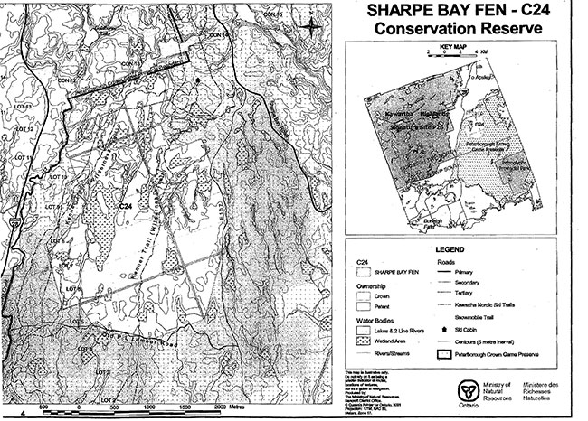
The Sharpe Bay Fen Conservation Reserve is situated midway between Bancroft and Peterborough, roughly 50 kilometres from each. It is located in Burleigh Township in the County of Peterborough (Inset, Figure 1).The Conservation Reserve consists entirely of Crown land, and is bordered by Crown land on the east, south and southwest portions of its boundary. It abuts private land on its north and northwest sides. Three unopened road allowances cross the reserve; these are in municipal ownership and therefore not part of the reserve. (Figure 1)
The purposes of this Statement of Conservation Interest (SCI) are to identify and describe the values of the Sharpe Bay Fen Conservation Reserve. The SCI also outlines the activities that occur within the reserve and provides guidelines for the management of current and future activities in the context of protecting the natural and cultural values.
Conservation Reserves are established by Regulation under the Public Lands Act. Statements of Conservation Interest are prepared under the authority of Procedural Guideline A-Resource Management Planning (PL Procedure 3.03.05).
1.1 Background information
| Name | Sharpe Bay Fen Conservation Reserve |
|---|---|
| Ecological Site Region/ Site District | 5E-11 |
| OMNR Administrative Region/ District/ Area | Southcentral Region/ Bancroft District/ Bancroft Area |
| Total Area (Hectares) | 636 |
| Regulation Date | August 10, 2000, by Ontario Regulation 461/00 |
| OBM map sheets | 1017725049450, 1017725049500, 1017730049450, 1017730049500 |
| UTM Coordinates | 7295 49510 centroid |
1.2 Representation/targets
Earth science representation:
Bedrock
- Belmont Domain, Elzevir Terrane of the southwestern part of the Metasedimentary Belt of the Proterozoic Grenville Province
- low relief area of bedrock barrens, exposed gneissic quartz monzonite
Surficial
- large peatlands over bedrock, interspersed with bedrock barrens and thin Limerick tills over bedrock
Life science representation:
Large undisturbed fen and peatland system, interspersed with bedrock barrens and shallow tills over bedrock. This is known habitat of the provincially rare Five-lined Skink (Eumeces faciatus).
Cultural resources representation:
No research has been done to date and there are no known values within the reserve.
Recreational opportunities:
Only a reconnaissance level inventory and assessment (Bean 2001) has been completed for recreational opportunities in the Conservation Reserve. As the Conservation Reserve is entirely within the Peterborough Crown Game Preserve, recreational hunting is not allowed. The area is used for cross-country skiing, hiking and various nature related activities. Recreational use of the area is locally significant.
1.3 Survey work
| Survey Level | Earth Sciences | Life Sciences | Cultural | Recreational | Other |
|---|---|---|---|---|---|
| Reconnaissance | Checklist 2000; | Checksheet 2001; Site Region 5E Report, Noble 1983 |
None | Checklist, 2001 | |
| Detailed | None | ||||
| Requirement | None | Not anticipated |
2.0 Values to be protected
The Conservation Reserve is located entirely within Hills (1959) ecological Site District 5E-9. Values include earth science, life science and recreational features, with an emphasis on life science representation values.
2.1 Earth science
Earth science values are focused on features (bedrock and surficial that represent the chronology of earth history in the province (Davidson, 1981).
The bedrock of the Sharpe Bay Fen Conservation Reserve is within the Belmont Domain, Elzevir Terrane of the Central Metasedimentary Belt of the Proterozoic Grenville Province. The Elzevir Terrane is one of five lithotectonic terranes of the Central Metasedimentary Belt. Within the Elzevir Terrane, the Belmont Domain is one of three structural domains. This geological environment is part of the modem organization of the complex products of the mid-Proterozoic Grenville orogenic events (Easton 1992a & b).
The felsic gneisses are typical of the plutonic rocks of the Belmont Domain, Elzevir Terrane (Frey, Duba 2000), and the site contributes to the conservation of the continental accretion theme (Davidson, 1981).
2.2 Life Science
The Sharpe Bay Fen Conservation Reserve is located within Hills (1959) ecological Site District 5E-11.
Representation:
This large peatland is situated on extensive marble bedrock deposits, and supports large Black Spruce-White Cedar fen forests as well as Black Ash-Cedar swamps and open shrubby areas. There are few open water bodies. It is the largest of several fens forests in ecological Site District SE-11.
Rock barrens and shallow till over bedrock are extensive. The Limerick till soils in this area are derived from a crumbly crystalline limestone, which gives the soils a high base content and a higher pH than average for the Site District. This is reflected in the vegetation (Merchant 2001).
Condition:
The fen areas have largely been protected from logging and other development by Eel’s Creek to the west, and by north/south-running ridges around it, and are therefore, relatively undisturbed.
In the upland areas, some forest management stand improvement was carried out in the 1960's.High levels of deer browsing on competitive vegetation have allowed natural White Pine and White Spruce to become established.
Diversity:
The area contains diverse lowland habitats, including treed and open swamps, fens and bogs of varied composition. These are interspersed with islands and ridges of rock barrens and shallow till, which contain mixed forests and open areas. The vegetation communities include species which are uncommon or absent in other parts of Site District SE-11.
Ecological considerations:
The Conservation Reserve is a part of the Peterborough Crown Game Preserve.
Special features:
The fen is the largest of several fen forests in ecological Site District SE-11.
Significance:
The Sharpe Bay Fen Conservation Reserve contains regionally significant fen forests and peatlands. It provides known habitat for the provincially rare Five-lined Skink (Eumeces faciatus).
2.3 Recreational/aesthetic values
The Sharpe Bay Fen Conservation Reserve lies within the Peterborough Crown Game Preserve, which is used extensively for recreational activities such as cross-country skiing, hiking and camping. Hunting is not allowed within the Crown Game Preserve, and therefore is not allowed within this Conservation Reserve. There are two cross-country ski trails through the reserve, and the Reserve is known to be used for hiking, wildlife (deer) viewing, and other nature related activities. There is little opportunity for fishing within this Conservation Reserve.
The current and expected levels of recreational activities within the Sharpe Bay Fen Conservation Reserve have local significance, and with the exception of the potential for wild fire, recreational use is considered to pose little threat to the other values of the reserve.
3.0 Management guidelines
3.1 Land tenure
Background:
Sharpe Bay Fen Conservation Reserve consists entirely of Crown land, except for some unopened road allowances within the reserve, which are in municipal ownership and therefore not part of the reserve (Figure 1). It is surrounded on three sides by Crown land, abutting private land on its north and northwest sides.
Except for a registered fur harvesting trapline (NO 91) and a commercial bait fishing license (Baitfish Block BU 2), both of which include this site, there are no land use permits, licenses or easements that apply to Crown land within the Conservation Reserve.
Guideline:
Sale of Crown lands within the Conservation Reserve is not permitted.
Land tenure will continue for fur harvest through the registered trapline area.
While baitfish harvesting is technically allowed, the absence of significant bodies of open water means that there is little opportunity for such activity to occur within the Conservation Reserve.
3.2 Existing/proposed development
Background:
Other than roads and trails, there is no development within this Conservation Reserve. A secondary road from Jacks Lake Road to the Peterborough Petroglyphs Provincial Park defines part of the east boundary of the reserve, and a tertiary forest access road, known as the Old Peterborough Lumber Road, defines part of its south boundary. Two ski trails cross the reserve, trending generally north/south (Figure 1).
Guideline:
No additional development is anticipated within the Conservation Reserve. New recreational trails (for non-motorized activities) may be considered provided they meet the Procedural Guideline B-Test of Compatibility (Appendix 1), and MNR's Environmental Assessment Act requirements.
The Ontario’s Living Legacy Land Use Strategy provides that controlled mineral exploration is permitted in specific new conservation reserves that have been identified as having provincially significant mineral potential. While there is currently little information indicating that this particular site may have provincially significant mineral potential, this determination has not yet been made. Roads necessary for access for mineral exploration and development are also permitted, with appropriate consideration for the protection of conservation reserve values. If mineral values are such that a site is to be developed as a mine, that area would be deregulated and an appropriate replacement area would be added to the conservation reserve.
3.3 Recreation activities
Background:
Existing known recreational activities include cross-country skiing, hiking, wildlife viewing and nature related activities.
Guideline:
Recreation use such as hiking, wildlife viewing, snowshoeing and cross-country skiing will be allowed to continue in the Conservation Reserve.
Sport hunting will not be allowed within the Conservation Reserve, as it is contained within the Peterborough Crown Game Preserve.
3.4 Commercial activities
Background:
Current commercial use of the Conservation Reserve includes fur harvesting (Trapping area NO 91) and Baitfish Block BU 2.
Mining activities are not known to have occurred within the reserve.
Guideline:
Fur harvest will continue to be allowed in the Conservation Reserve. Baitfish harvesting within the reserve is also allowed, although impractical.
Conservation Reserves do not permit mining, commercial forest harvesting, hydroelectric power development, the extraction of aggregate, peat, soils, or other industrial uses. (Public Lands Act, Ontario Regulation 805/94).Other new commercial activities must meet the requirements of Procedural Guideline B-Test of Compatibility.
The mineral potential of the area will be assessed in accordance with Ontario’s Living Legacy Land Use Strategy commitments; if areas of provincially significant mineral potential are identified, controlled exploration will be allowed, as discussed in Section 3.2.
3.5 Aboriginal interests
Background:
During the consultation process on the refinement of the boundary of this conservation reserve, Ministry staff discussed this conservation reserve with representatives of the Curve Lake First Nation.
Guideline:
The regulation and management of this conservation reserve will not impede the exercise of existing Aboriginal or treaty rights.
3.6 Natural Resource Stewardship
Guideline - general:
The Conservation Reserve will be managed with an emphasis on ensuring that the natural ecosystems and processes of the Conservation Reserve are not negatively affected by current and future activities. Therefore, applications for specific uses will be carefully studied and reviewed. The Ministry of Natural Resources, partner organizations, and/or the proponents may undertake such studies.
Guideline - vegetation:
The intent of this site is to allow the existing vegetation communities to evolve naturally.
It is recognized that forest fire has been a part of this system in the past, but at this time it is not anticipated that fire will be used as a tool for the management of the site’s vegetation communities. The Conservation Reserve is in MNR's East Fire Region Sector 1 (Haliburton Highlands - Georgian Bay). This is classified as an intensive fire management zone where the objectives are to minimize hectares burned, values destroyed and social impact, and to extinguish fires as soon as possible.
Until a more detailed local natural resource plan or fire management plan provides alternate direction, fire protection for the Sharpe Bay Fen Conservation Reserve will be carried out in accordance with the approved Fire Management Strategy that applies to surrounding Crown lands. A 'light on the land' be approach to fire suppression will desirable in order to protect natural values; for example, minimal use of heavy equipment, trenching, tree cutting, camp construction, etc will occur.
Programs may be developed to control forest insects and diseases in the Conservation Reserve where these threaten significant values in or adjacent to the site. Where insects or disease threaten significant values, in or adjacent to the site, control will be directed as narrowly as possible to the specific insect or disease. Biological control will be used wherever possible.
Guideline - wildlife:
The management of game and fur species in the Sharpe Bay Fen Conservation Reserve will continue consistent with the wildlife management unit (WMU-60A), fur harvest trapline area (NO 91) and the Peterborough Crown Game Preserve, within which it lies.
3.7 Cultural Resource Stewardship
No values have been identified within the Sharpe Bay Fen Conservation Reserve to date. Interested partners will be encouraged to undertake inventories and studies of the area.
3.8 Client services
Background:
Other than a fact sheet, which is available for this Conservation Reserve, there are no services provided.
Guideline:
The focus will remain on low key information and self-interpretation of Conservation Reserve values and features. Consideration will be given to the strategic location of identity signs where trails and adjacent roads approach or cross the boundaries of the Conservation Reserve.
3.9 Research
Background:
Research to date has consisted of reconnaissance surveys and checklists of the earth science, life science and recreation values of the reserve. Additional assessment is not planned at present, though may occur if future opportunities are presented.
Guideline:
The Ministry will consider whether there is a need for further inventory and documentation of natural values, and/or assessment of use/activity impacts. Research proposals and activities must follow Procedural Guideline C-Research Activities in Conservation Reserves (PL Procedure 3.03.05) (Appendix 2).
The mineral potential of the area will be assessed in accordance with Ontario’s Living Legacy commitments once the criteria for determining Provincially Significant Mineral Potential have been approved.
3.10 Marketing
Background:
There has been no direct marketing of the Sharpe Bay Fen Conservation Reserve to date. Promotion and information about this site has been primarily through the Ontario’s Living Legacy planning process, and recent Bancroft District public consultation regarding the regulation of the boundaries of this site.
Guideline:
Direct marketing of the Sharp Bay Fen Conservation Reserve is not proposed. Fact sheets will continue to be available to inform the public about the role of the Conservation Reserve in a provincial system, and about its specific values.
4.0 Implementation
Administrative responsibility for the Sharpe Bay Fen Conservation Reserve lies with MNR's Bancroft Area, Bancroft District. Implementation of this Statement of Conservation Interest will primarily involve monitoring activities to ensure adherence to the management guidelines. Other activities will include distribution of a fact sheet highlighting the important natural heritage values of the site, and responding to inquiries.
5.0 Review and revision of the Statement of Conservation Interest
The Sharpe Bay Fen Conservation Reserve Statement of Conservation Interest will be reviewed on an ongoing basis.
If changes are required in the Statement of Conservation Interest, they will occur through a standard process of minor and major amendments. Minor amendments will be processed in a relatively informal manner and will require the approval of the Area Supervisor. These amendments will deal with uses and activities that do not affect any of the policies in this SCI, such as new uses and/or activities that are consistent with existing uses.
Uses and/or activities that were not anticipated in the approved SCI and that have the potential to have a negative impact on the values of the Conservation Reserve will require a major amendment. This will include an opportunity for public comment and input, and will require the approval of the District Manager and Regional Director.
References
Bean C. 2001. Recreation Inventory Checklist. Sharpe Bay Fen Conservation Reserve. Ontario Ministry of Natural Resources, Bancroft.
Davidson R.J. 1981. A framework for the conservation of Ontario’s earth science features. Ontario Ministry of Natural Resources, Toronto.
Easton R. M. 1992a The Grenville Province and the Proterozoic history of central and southern Ontario: in Geology of Ontario, Ontario Geological Survey, Special Volume 4, Part 2, p715-904.
Easton R. M. 1992b Tectonic evolution of Ontario. Part 3: Mesoproterozoic evolution of the southeast margin of Laurentia: in Geology of Ontario, Ontario Geological Survey, Special Volume 4, Part 2, p1302-1314.
Frey E.& Duba D. 2000. Earth Sciences Checksheet, Sharpe Bay Fen Conservation Reserve. Ontario Ministry of Natural Resources, Peterborough.
Hills, G.A. 1959. A ready reference to the description of the land of Ontario and its productivity. Ontario Department of Lands and Forests, Division of Research, Maple, Ontario.
Merchant B. 2001 Life Sciences Checksheet. Sharpe Bay Fen Conservation Reserve (Interim) Ontario Ministry of Natural Resources, Bancroft.
Noble T.W. 1983. Biophysiographic Analysis of Site Region 5E. Central (Algonquin) Region, Ontario Ministry of Natural Resources.
OMNR 1983. Bancroft District Land Use Guidelines. Bancroft District, Algonquin Region, Ontario Ministry of Natural Resources.
OMNR 1999. Ontario’s Living Legacy, Land Use Strategy, July 1999.Ontario Ministry of Natural Resources, Peterborough.
Appendix 1 Procedural guideline B - Land Uses-Test of Compatibility (PL Procedure 3.03.05)
The Conservation Reserve policy provides broad direction with regard to the permitted uses. The policy provides only an indication of the variety of uses that will be considered acceptable in Conservation Reserves. The only caution is that "any new uses, and commercial activities associated with them, will be considered on a case by case basis, and, they must pass a test of compatibility to be acceptable." What does a 'test of compatibility' mean?
An examination of this must start from the premise of why an area is set aside-specifically, its representative natural heritage values. Criteria are then identified to guide compatibility considerations. These criteria apply to the long-term acceptability of both existing uses and new uses.
-
Conformity to SCI/RMP: SCI describes values for which an area has been set aside and the range of appropriate uses that will be permitted in the area. SCI may also speak to the acceptability of other 'new' uses currently not occurring in the area.
The first 'test' is:"do proposed new land uses and/or commercial activities conform to the direction of the SCI/RMP for the Conservation Reserve? Would the new use(s) depart from the spirit of appropriate indicator land uses in the SCI/RMP?"
- Impact Assessment: If the proposed use(s) pass test 1 it is important to determine their impact on the area before they are approved. This should include the following:
- Impact on natural heritage values: "will the new use(s) impact any natural values in the area? If so how and to what degree? Is it tolerable?"
- Impact on cultural values: "will the new use(s) impact an historical or archaeological values in the area?"
- Impact on research activities: ''will the new use(s) affect research activities in the area?"
- Impact on current uses: "will the new use(s) have any negative impact on the array of current uses?"
- Impact on area administration: "will the new use(s) increase administrative costs and/or complexity?" (For example, the cost of area monitoring, security and enforcement).
- Impact on accommodating the use outside the Conservation Reserve: "Could the use(s) be accommodated as well or better outside the Conservation Reserve?'!
- Impact on socio-economics of the area: "will the new use(s) affect the community (ies) surrounding the area in a positive or negative way?" (For example, will the new use make an area less remote thereby affecting a local tourism industry that is dependent on the area’s remoteness for its appeal?"
- Impact on area accessibility: "does the new use(s) give someone exclusive rights to the area or a portion of the area to the exclusion of other existing uses?"
Appendix 2 Procedural Guideline C-Research Activities in Conservation Reserves (PL Procedure 3.03.05)
Purpose
To encourage contributions to the goal of Conservation Reserves by:
- Providing direction for research activities associated with Conservation Reserves; and
- Establishing a process for the review and approval of proposals by researchers, which could have an impact on the values protected by the Conservation Reserve
Definition
Research means any investigation or study of the natural, cultural, economic, management or other features or characteristics of Conservation Reserves.
Guidelines
Research will be encouraged to provide a better understanding of the natural values protected by a Conservation Reserve and to advance their protection, planning and management. The Statement of Conservation Interest will define, for each Conservation Reserve, the key research issues, set out the parameters within which research may occur and identify research needs.
Applications and approvals
Researchers must apply in writing to the Area Supervisor for permission to conduct research. The request letter must contain a statement explaining why the proposed research should be undertaken in the particular Conservation Reserve in preference to another location.
Proposals will be reviewed and approved by the Area Supervisor, guided by the SCI prepared for each reserve (see Guideline A- Resource Management Planning) and using Guideline B-Land UsesTest of Compatibility. Permission must be granted in writing, including any conditions to be met in conducting the research, prior to the undertaking of any research project.
Term and conditions
Permission to conduct research under this policy will be valid for a period of 12 consecutive months from the date of issue. Permission to continue a research project for an additional periods of 12 months or less may be granted upon submission of a written request and a progress report. The Ministry may require the posting of collateral to assure that the terms and conditions of granting permission are met.
The Area Supervisor may suspend or revoke permission at any time for failure on the part of the researcher to meet:
The intent of this policy:
- The requirements under the Public Lands Act, including all amendments, where applicable
- The requirements under any other Act or regulations of Ontario or Canada, including those governing the taking, handling, storing, confining, trapping, excavating and marketing any specimen, artifact, information or action (for example, scientific collector’s permit)
- The conditions and agreements specified in granting permission
Final report
The researcher will submit copies of reports, publications and theses following the results of the project to the Area Supervisor.
Map 1: Sharpe Bay Fen C24 Conservation Reserve