Sifton Township Conservation Reserve Management Statement
This document provides policy direction for the protection, development and management of the Sifton Township Conservation Reserve and its resources.
Statement of Conservation Interest
Ministry of Natural Resources
Rainy River/Manitou Area
Fort Frances District
February, 2002
John Munroe
District Planner
Approval statement
I am pleased to approve this Statement of Conservation Interest for the Sitton Township Conservation Reserve.
This Statement of Conservation Interest provides guidance for the management of the conservation reserve and the basis for the ongoing monitoring activities. More detailed direction at this time is not anticipated. Should significant facility development be considered or complex issues arise requiring additional studies, more defined management direction, or special protection measures, a more detailed Resource Management Plan will be prepared with full public consultation.
The public was consulted during the original regulation process and further consultation is not required at this time.
The conservation reserve will be managed under the jurisdiction of the Rainy River/Manitou Area Supervisor, Fort Frances District, Ministry of Natural Resources.
Signed by:
C. Lauer
Regional Director
Northwest Region
Date: 02/12/20
1.0 Introduction
On July 16, 1999, the Ontario Government released the Ontario’s Living Legacy Land Use Strategy to guide the planning and management of Crown lands in central and parts of northern Ontario. A major part of the Ontario’s Living Legacy Land Use Strategy was a government intent to establish 378 new protected areas. This commitment marks the biggest expansion of provincial parks and conservation reserves in Ontario’s history.
The Sifton Township Conservation Reserve is part of this significant expansion of Ontario’s protected areas system.
Conservation reserves are areas of Crown land set aside by regulation under the Public Lands Act, complementing provincial parks in protecting representative natural areas and special landscapes. Most recreational (e.g. hiking, skiing, tourism related uses, nature appreciation) and non-industrial, commercial (e.g. fur harvesting, commercial fishing and bait harvesting) activities that have traditionally been enjoyed in the area will continue, provided that these uses do not impact on the natural features needing protection. Hunting and fishing is permitted within all new conservation reserves proposed through Ontario’s Living Legacy.
Commercial timber harvesting, mining and mineral exploration, aggregate extraction and commercial hydroelectric development are prohibited in conservation reserves.
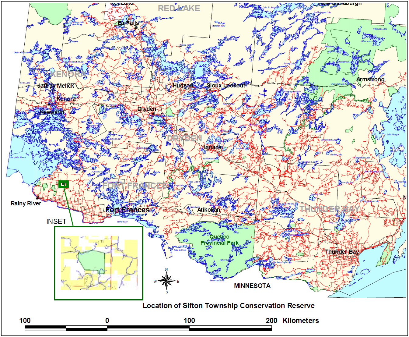
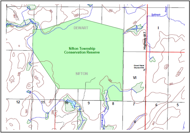
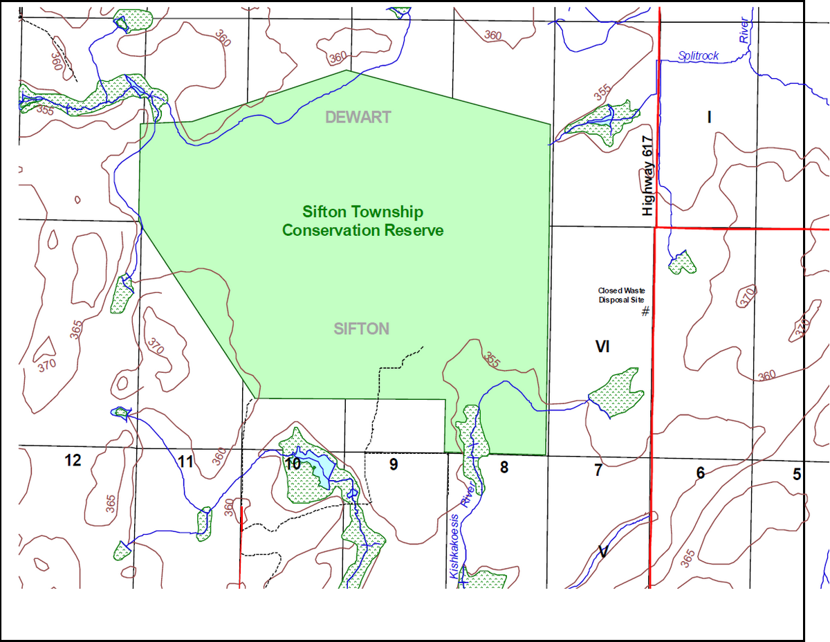
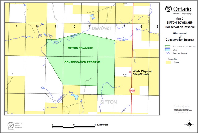
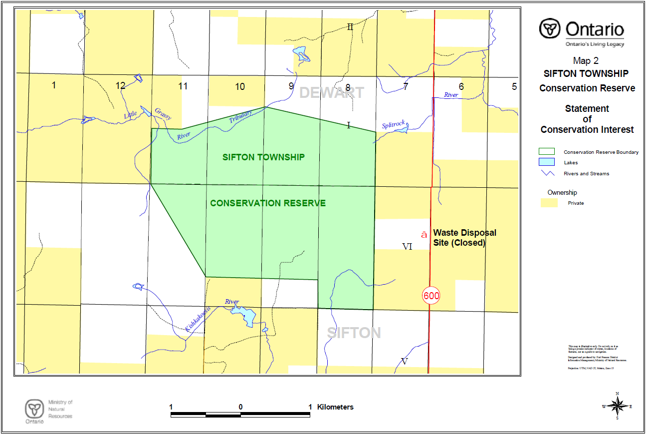
Sifton Township Conservation Reserve is located in northwestern Ontario in the Fort Frances Administrative District of the Ontario Ministry of Natural Resources, approximately 23 kilometres north of the town of Stratton. Much of the surrounding land has been alienated from the Crown and consists of private, patented properties. Moreover, the predominant land use on these properties is agriculture. A highly developed system of roads, akin to those more commonly associated with that found in more southerly portions of the province, surrounds the conservation reserve. Highway 600 runs north-south paralleling the eastern boundary of the Conservation Reserve, approximately 1 kilometre distant.
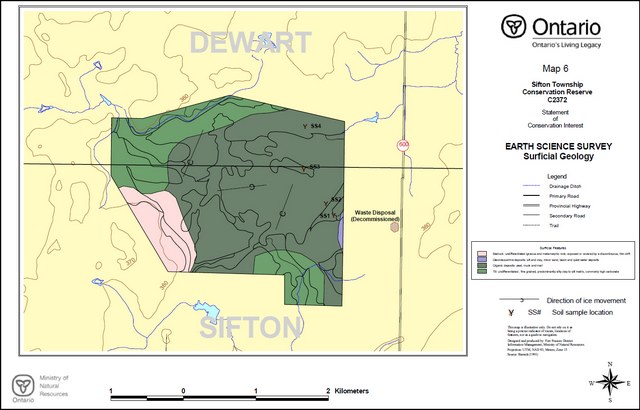
Sifton Township Conservation Reserve is located within Hills' Site Region 5S and Site District 5S2 (Hills, 1961). The area occupies a peneplain that extends southwestward into the adjacent United States, and is underlain by the felsic intrusive rocks of a lobe of the Sabaskong Batholith. Surficial geological features are complex, being formed as a consequence of the successive advance of two lobes of the Laurentide Ice Sheet across the area during the late Wisconsin period (Bajc, 1991) and periodic inundation by the waters of glacial Lake Agassiz. The latter deposited sediments between and following the advances of the ice margins across the area. The result is a complex stratigraphy of glacial tills interspersed by glaciolacustrine sediments. The later deposits are rich in carbonates due to their western origins. Deep organic deposits were accumulated in the shallow depression between the surrounding uplands over the underlying glaciolacustrine deposits and range in depth from 2 to 3 metres.
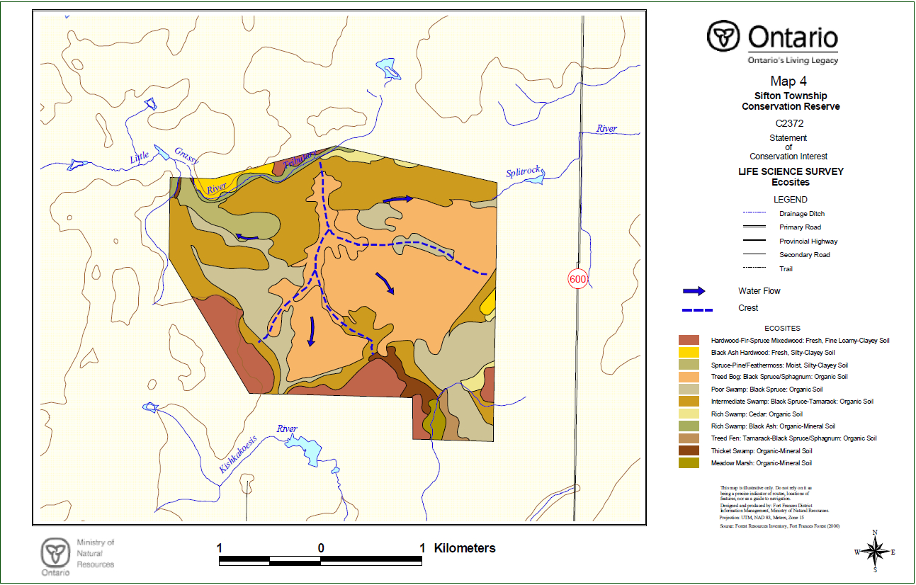
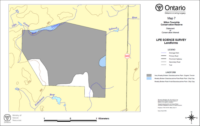
The wetlands and surrounding upland forests captured by the Sifton Township Conservation Reserve include representative areas of hardwood-spruce-fir mixedwood, black ash hardwoods, spruce-pine conifer, black ash swamp, black spruce swamp, cedar swamp, thicket swamp, treed bog, treed fen and meadow marsh. The site is focused around a classic raised bog of the crested ridge type considered rare in northwestern Ontario (Noble, 1997). The Conservation Reserve forms part of a series of large peatlands draining westwards to Lake of the Woods and the Sifton Township site specifically forms part of the headwater area for three significant local river systems. The natural drainage of the peatlands towards the northeast, south and northwest into the Splitrock River, Kishkakoesis River and Little Grassy River systems, respectively, has created a pattern visible from the air and on satellite images and aerial photographs. The site lies within an area that contains species not commonly found elsewhere in northwestern Ontario, such as largetooth aspen, green ash, red maple, basswood, red oak, red-headed woodpecker, loggerhead shrike, black-billed magpies, bobcat, coyotes, porcupines, raccoons, white-tailed jackrabbit and american badger. Eastern white cedar is common throughout the area owing to the presence of calcareous glacial tills and clay glaciolacustrine deposits. The occurrence of species here which are more common further to the south led to designation of the area as part of the Great Lakes - St. Lawrence Forest Region (Rowe, 1972). Rowe recognizes the Rainy River area as part of a separate section of the forest region that is influenced by the northward movement of the southern forest, the prairie to the west and the northern forest.
The Conservation Reserve does not contain any known rare species, however detailed life science surveys would be required to confirm this. Species diversity within this Conservation Reserve is not expected to be as great as that for the Nature Reserve class Provincial Parks lying to the west. Within the Conservation Reserve a well-developed network of trails can be observed, created by the movements of the larger mammals, such as deer, across the area. The dense conifer of the treed portions of the Conservation Reserve provides habitat for boreal species such as red squirrel, marten and great grey owl. The existence of the Conservation Reserve as an undisturbed island of both treed and untreed habitat in the midst of an agricultural area, coupled with the range of habitats represented, enhances its value for wildlife, at least in a local context.
The site has low potential for outdoor recreational activities, access directly to and within much of the conservation reserve being limited, owing to the dominating wetlands. Access may be gained, with some difficulty, on foot off of Highway 600.
The purpose of this Statement of Conservation Interest is to identify the natural heritage values of the Sifton Township Conservation Reserve, the activities which occur there and, through a set of management guidelines, outline the activities which will and will not be permitted, as well as the management direction for the area (MNR, 1997).
2.0 Background information
The Sifton Township Conservation Reserve is an area protected as representative of a raised bog feature considered rare in northwestern Ontario. Originally recommended as a candidate protected area under the Nature’s Best initiative of the Ontario Ministry of Natural Resources (Noble, 1997), the area was included amongst those recommended as a proposed Conservation Reserve under Ontario’s Living Legacy and approved in the resulting Land Use Strategy (OMNR, 1999). It is a roadless, largely undisturbed tract practically accessible with some difficulty only on foot. The peatland features and surrounding upland margins, the sites role as a headwater for three locally-important drainage systems, and a variety of forest and wetland ecosites and associated flora and fauna all contribute to the Conservation Reserve’s role within Ontario’s system of parks and protected areas.
Table 1. Background Information
| Name | Sifton Township Conservation Reserve |
|---|---|
| Site Region / Site District | 5S2 |
| Ecosite Class | ES 29, 30, 31, 34, 35, 36, 37, 38, 40, 44, and 46 |
| OMNR Administrative Region / District / Area | Northwest / Fort Frances / Rainy River-Manitou Area |
| Total Area (ha) | 712 |
| Regulation Date | Not yet regulated. |
| First Nations with Interest in Area | Treaty Three: Rainy River and Big Grassy First Nations (Note: Although not identified specifically as an area of interest, the area is within a larger area which is the subject of ongoing land claim negotiations. Other First Nations may also have an interest.) |
| OBM | 15U 4125/54184 |
| Lat./Long. | 48°55'00"N; 94°11'30"W |
| Basemap | 2015410054100 |
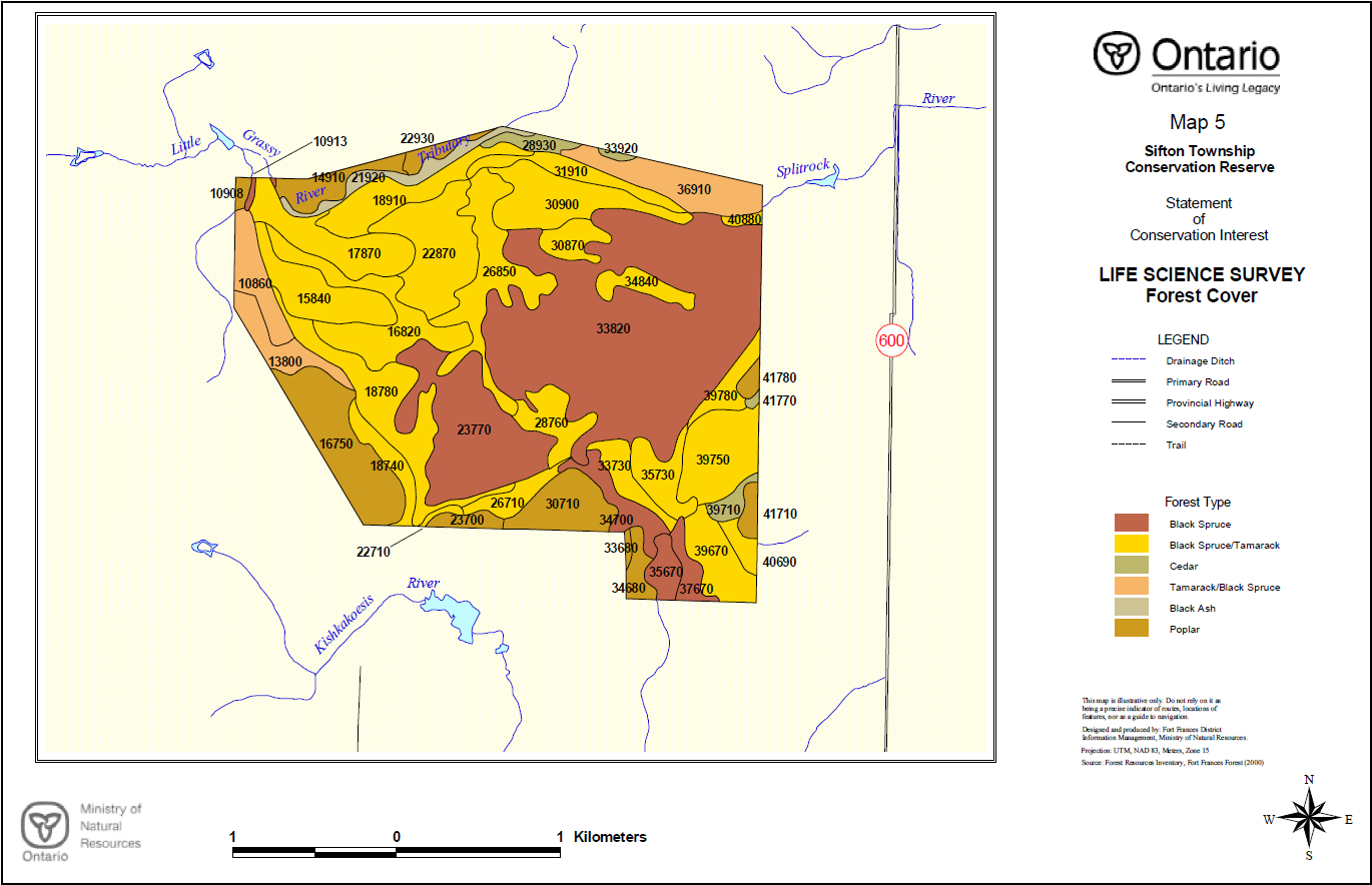
| Forest Cover | Dominated by black spruce, tamarack and cedar conifer lowlands. Black ash hardwood lowlands are common. The margins of the wetlands within the site include upland mixedwoods, including spruce, balsam fir and poplar. (Refer to Appendix D) |
| General Location Description | The Sifton Township Conservation Reserve is situated approximately 90 kilometres northwest of the Town of Fort Frances, 28 kilometres north of the village of Stratton and 4 kilometres northwest of the hamlet of North Branch. The site includes the wetland and surrounding upland margins forming part of the headwaters of the Little Grassy, Kishkakoesis and Splitrock Rivers. Lying entirely within unorganized territory, the Conservation Reserve straddles the southern and northern boundaries of Dewart and Sifton Townships, respectively. (refer to Figure 1.) |
| Access | Access can be gained via Highway 600. Limited parking is available at the gated entrance to the decommissioned waste disposal site adjacent to the highway. Direct access is by foot only, with few trails available. Permission must be obtained from adjacent property owners prior to crossing private lands. |
2.1 Targets
This section provides a summary of the earth and life science system and values, cultural resources represented and recreational opportunities available or possible.
Table 2. Summary of Social, Economic and Environmental Opportunities
| Life Science Representation | Although it may be considered primarily an earth science feature, the raised bog that dominates the wetland features of the Conservation Reserve manifests itself as a distinct ecology and associated plant community as well. The area contains representation of 11 ecosites classified under the Northwestern Ontario Forest Ecosystem Classification (Racey et al, 1996), including 3 upland types as well as 8 wetland types. The numbers and variety of bird species, both waterfowl and uplands species that the area supports is not well known, with other areas further to the west which are well-known amongst birders, naturalists and investigators commanding most of the local attention. With little open water, little habitat for many such species occurring in high numbers elsewhere is provided by the Conservation Reserve. With a predominance of conifer, habitat for birds is weighted heavily towards those species favouring such forest types. Although not observed directly, it is anticipated that some regionally unusual species can be observed here at least as occasional visitors, such as red-headed woodpecker, loggerhead shrike, western kingbird, and black-billed magpies, although these may favour the margins of the area adjacent to open farmland. Although much of the wetland area within the Conservation Reserve does not provide ideal habitat for most mammals, the adjacent uplands, given their relative scarcity owing to the surrounding agricultural practices, do provide some refuge for a variety of species. Regionally unusual species commonly found in the area include raccoons, bobcat, white-tailed jackrabbit, and american badger. Detailed plant surveys have not been conducted on the site. No records of rare species occurring in the area exist (NHIC, 2001). Species known to occur here are representative of plant communities associated with both ombrotrophic and minerotrophic bog and fen features, swamps and marsh, as well as upland forested areas. |
|---|---|
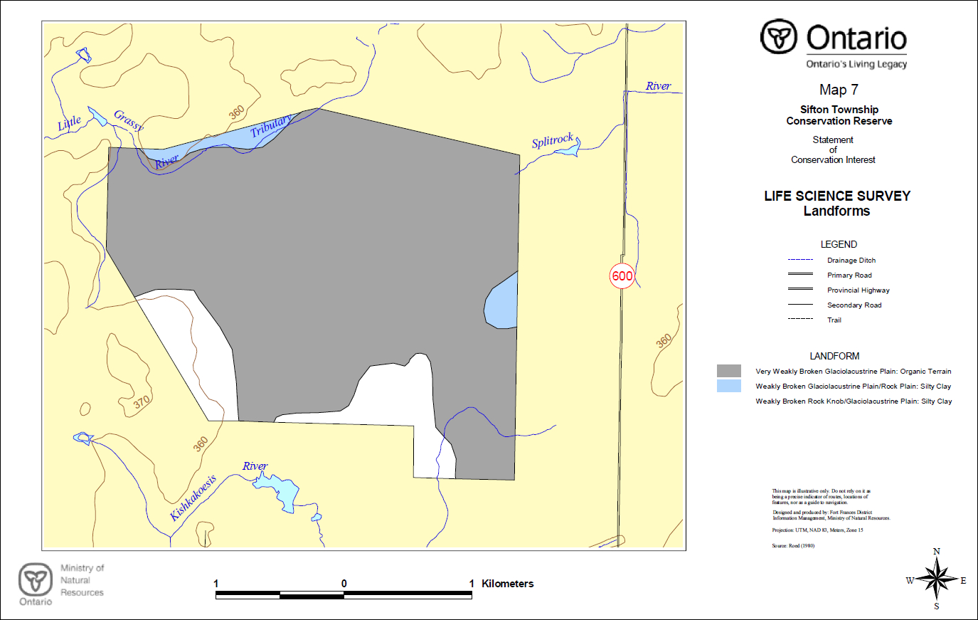
| Earth Science Representation | Deep glaciolacustrine silts and clays and thin glacial outwash sandy tills deposited over felsic intrusive granitoid bedrock (Johns, 1988 and Bajc, 1991). The dominant landform features are very weakly broken glaciolacustrine plain and weakly broken ground moraine over bedrock plain (Roed, 1980). Peatlands contain moderately deep organic deposits, averaging 2 to 3 metres in depth, consisting of fibric peatymors (Northland Associates Ltd., 1984). The peatlands are dominated by a sinuous, ridged, raised bog feature that dissects the wetlands into four distinct drainages flowing into three separate river systems. |
| Cultural Representation | The site contains no known cultural resource values. Although located within an area of relatively intensive human use, both currently and historically, the dominantly wetland nature of the Conservation Reserve limited historical uses, as it does today. |
| Recreational Opportunities | The overall recreational potential of the Conservation Reserve is extremely limited and is ranked as low to very low. Little evidence of current human activity was found. Of the potential recreational activities identified, those which are associated with the appreciation of the life science values are deemed to be the most viable, although these are somewhat hampered by access limitations and difficulty. Such activities could include nature study, including bird and wildlife viewing and photography. The high population of game species, particularly white-tailed deer, as indicated by the well-used game trails throughout the wetland features, would suggest that hunting might be a viable recreational pursuit within the area. However, this activity is also limited by access difficulties and may be confined practically to some of the areas along the margins and surrounding lands. |
2.2 Survey information
This section provides an overview of the inventories completed, their level of detail and any further inventories required.
Table 3. Level of survey performed
| Survey Level | Life Science | Earth Science | Cultural | Recreational |
|---|---|---|---|---|
| Reconnaissance | Yes. Noble, 1997; Munroe, 2002a. | Yes. Munroe, 2002b | No | Yes. Munroe, 2002c |
| Detailed | No | No | No | No |
| Requirement | No | No | No | No |
The reconnaissance surveys which have been completed, in conjunction with other values and earth/life science records for the area (OMNR, 2002) are deemed sufficient in scope and detail to determine management direction for the conservation reserve. More detailed surveys may be undertaken at a later time if circumstances change.
3.0 Values to be protected
This section provides a description of the key natural heritage values on the site (Appendices) and their condition relative to past resource use and management activities. It also addresses the values' sensitivity to future land use and management activities.
3.1 Values identified in the Conservation Reserve
Table 4. Values identified in the conservation reserve
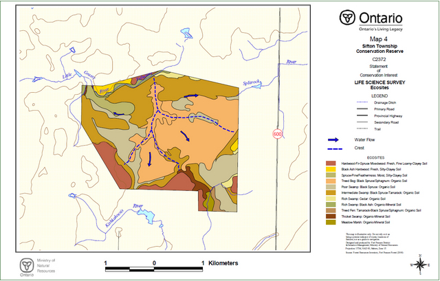
| Life Science | Identified ecosites within the Conservation Reserve include:
Those parts of the Conservation Reserve supporting tree growth include discreet areas dominated by black spruce, tamarack, eastern white cedar, black ash, and aspen. The calcareous tills and glaciolacustrine deposits common in the area support the occurrence of cedar throughout the site, both as a dominant and component species. The age of the forest cover averages 80 to 100 years, with the oldest trees represented by the cedar dominated stands that are estimated to be up to 140 years of age. The lowland black spruce in the western portions of the site tends to be somewhat older at 110 years than those found in the eastern half. The latter situation may be the consequence of historical fire in the eastern portions where bog conditions predominate, while in the west the tendency towards conifer swamp may have limited fire. Appendix C contains a forest cover map and Appendix D contains stand listings for the Conservation Reserve. The existence of the Conservation Reserve as an undisturbed island of both treed and untreed habitat in the midst of an agricultural area, coupled with the range of habitats represented, enhances its value for wildlife, at least in a local context. Perhaps most visible amongst the species is represented by the large local white-tailed deer population. Deer are frequently observed crossing the surrounding roads and highway travelling to and from the Conservation Reserve. Within the Conservation Reserve a well-developed network of trails can be observed, created by the movements of the larger mammals, such as deer, across the area. The vegetation of the Conservation Reserve is typical of the ecosites represented, with no rare plants having been documented for this site. No detailed survey of plant species has been undertaken for the site. |
|---|---|
| Earth Science | Extensive areas of wetlands and deep overburden make access to and direct observation of geological features difficult, and much of the information is therefore inferred. Located within the westernmost portion of the Wabigoon subprovince and the Rainy River area, Sifton Township Conservation Reserve lies upon the felsic igneous rocks of a lobe of the Sabaskong batholith, north of the mafic metavolcanic rocks of the Rainy River greenstone belt. The rock in this location consist of a foliated granodiorite with varying percentages of hornblende and biotite with dikes of aplite and pegmatite (Johns, 1988). Located on the northwestern edge of a peneplain extending into adjacent Minnesota, the Conservation Reserve contains landform features representing very weakly broken glaciolacustrine plain and weakly broken bedrock plain. Surficial deposits are dominated by sandy glaciolacustrine silts and clays, with occurrences of ground moraine tills over bedrock, particularly along the southwesterly margins of the wetlands. The tills and lake sediments nearest the surface are of western origin and contain calcareous material, having been deposited by the last advance of the Keewatin glacier and the last high stand of glacial Lake Agassiz in late Wisconsin times. Quaternary stratigraphy is complex with deposits estimated to range from 10 to 20 metres in depth in this part of the Rainy River Area (Bajc, 1991). Recent deposits are represented by the peat that occupies much of the shallow basin of the Conservation Reserve. These deposits have been measured at 2 to 3 metres in depth over the silty-clayey glaciolacustrine deposits (Northland Associates Ltd., 1983 and Munroe, 2002a). The peatlands tend to be ombrotrophic, or influenced primarily by rainfall in the east, and increasingly minerotrophic, or influenced by seepage of mineral-laden waters through the peat, towards the west. The wetlands of the Conservation Reserve are subdivided into four drainage basins separated by low ridge crests of raised, treed bog. The two southern basins drain into tributaries of the Kishkakoesis River system, the nortwestern basin into the Little Grassy River system and the northeastern basin into the Splitrock River system. |
| Cultural | The area contains no identified cultural values. The only significant human influence identified is an old cleared survey line marking the boundary between Sifton and Dewart Townships, which is evident from the air but difficult to discern on the ground. One old trail enters the site from private lands to the south but is grown-in. |
| Aboriginal | The area contains no identified aboriginal values. |
| Tourism | Although the potential exists for commercial tourism based upon low-impact activities such as birdwatching and nature photography, difficulties associated with access limit such potential. Such operations may be more viable if considered within the context of the system of wetland-centred parks and protected areas in the Rainy River area, including Cranberry Lake, Spruce Islands, Agassiz Peatlands and Sable Islands Provincial Parks. |
| Recreational Fishing | The Conservation Reserve contains little open water and therefore has no recreational fishing potential. |
| Recreational/ Commercial Hunting | Hunting potential for deer and upland birds is judged to be good, although access is a serious limitation. No significant evidence of hunting activity within the site has been found. Hunting opportunities around the periphery of the Conservation Reserve may be better, although landowner permission would be required in some instances to cross private property. The area contains portions of two Bear Management Areas (BMA's), FF9A-15 and 9A-33. Again, no overt signs of bear hunting activity have been observed. The closure of the waste disposal site immediately to the east of the Conservation Reserve may limit the number of bears attracted to the area, and access is once again a limiting factor. |
| Mining | Due primarily to the depth of overburden in the area that hampers exploration coupled with the removal of the area of the conservation reserve from staking activities and the preponderance of private lands in the area surrounding the conservation reserve, little historical exploration has occurred. The area surrounding the conservation reserve contains no active mining claims, with exploration in the area tending to focus on the area of the Rainy River Greenstone Belt to the southeast, where active claims do exist. The area is ranked as low in terms of mineral potential (Springer, 1978). |
| Aggregate | The area is generally low potential for aggregate extraction, with deeper deposits tending to be glaciolacustrine silts and clays or occasional shallow tills over bedrock. (Roed, 1980) No aggregate pits currently exist in proximity to the Conservation Reserve. |
| Forest Harvest | Apart from some periodic logging of Crown parcels surrounding the Conservation Reserve, no forest harvesting has been documented in this area. |
| Trapping | The Conservation Reserve contains portions of two traplines. Trapline FF02-1890 lies within the southern portion of the site, and registered trapline FF02 occupies the northern portion in Dewart Township. No evidence of trapping was observed within the site. |
| Wild Rice | Commercial wild rice harvesting currently does not occur within this conservation reserve, nor have stands been identified. |
| Wildlife | Commercial game species, such as bear and deer can be found throughout this area. No known nesting sites have been identified within the area. The forest provides habitat for species favouring mature conifer forest. Beaver are limited to areas near the periphery of the wetland features where distinct watercourses develop. |
| Commercial Fish | No commercial fishing for human consumption exists within the conservation reserve. Commercial baitfshing does occur, with the area forming parts of baitfish blocks FF-10-004 and FF-10-005, and will be permitted to continue. The latter activity is confined to the periphery of the area where distinct watercourses develop. |
3.2 Values protection
The intent of this Statement of Conservation Interest is to protect the identified values by establishing management guidelines for existing and potential uses in this area, given the level of past disturbance and the nature of the existing features. Uses and activities which are permitted, not permitted or conditionally permitted are governed by the policies applying to Conservation Reserves as stated in the Land Use Strategy and existing Conservation Reserve policy. Any new uses, and commercial activities associated with them, will be considered on a case by case basis, and must pass a test of compatibility to be acceptable. Compatibility is normally determined through a planning process. The policies outlined in this Statement of Conservation Interest do not supersede any Aboriginal or treaty rights that may exist, or other legal obligations.
Forest values
The upland forest types and ecosites identified surrounding the primary wetland features of the Conservation Reserve will continue undergoing natural successional changes already initiated, towards a spruce-fir forest without the advent of a major disturbance such as fire. The eastern white cedar forest and black ash lowland ecosites are not expected to change, given the autecology of the primary species. The treed and untreed peatland features are also likely to remain unchanged in the absence of natural disturbances such as fire. Human activities that represent the greatest potential impacts on forest structure, such as logging, mining and hydroelectric development, will not be permitted. However, sustaining these values in the long-term may require development of a vegetation management plan and natural disturbance strategy.
Activities occurring on adjacent lands surrounding the Conservation Reserve are not expected to have a significant impact on the ecology of the site, with one possible exception. Unlike other wetland areas in the Rainy River area, drainage of adjacent lands through ditching has been limited in this location. With the site representing the headwaters of three developed drainage systems, the area is perhaps better drained naturally than those are elsewhere, precluding the need for ditching. Nevertheless, should such projects be proposed or undertaken they would constitute a potential cause for concern relative to the possible impacts on the water table and dependent ecology within the protected area. Should such occasion arise, the active co-operation of surrounding landowners will be necessary to limit such impacts.
Recreational and commercial values
The Sifton Township Conservation Reserve contains a significant wetland feature that may hold interest for amateur and professional naturalists. There is the potential for a number of low impact, non-consumptive recreational activities such as wildlife viewing and photography, although access difficulties are expected to continue to limit use.
The existing traplines, baitfish harvest areas and bear management areas within the conservation reserve will remain and existing uses associated with them allowed to continue. New operations may be considered, subject to the "test of compatibility". Normal application of controls such as quotas and seasons are designed to ensure that affected wildlife populations remain sustainable. Use of existing trails will be allowed to continue. Proposals for the development of new trails to permit access for these activities will be considered carefully to ensure that the values of the Conservation reserve are protected. Recreational hunting will be permitted, although it is expected that access limitations will restrict this activity to the margins of the area and the level of use may remain relatively low.
Tourism values
Access to this area is on foot from surrounding lands. Some old trails and logging roads around the margins do exist, but are not maintained and often involve crossing private lands. Little evidence of recent human activity within the site can be found. Some potential may exist to develop tourism based upon low-impact activities such as birdwatching and nature photography. Such operations may be more viable if considered within the context of the system of wetland-centred parks and protected areas in the Rainy River area, including Cranberry Lake, Spruce Islands, Agassiz Peatlands and Sable Islands Provincial Parks.
4.0 Management guidelines
4.1 Land tenure
The Sifton Township Conservation Reserve consists entirely of Crown land and no disposition of Crown land by sale is permitted within the conservation reserve. The surrounding and adjacent lands consist of a mixture of private and Crown lands. The main wetland features for which the Conservation reserve was proposed are entirely captured within the boundaries of the site as they now exist. No expropriation or purchasing of private land for inclusion in the conservation reserve is planned. New leases or land use permits may be considered for approved activities, subject to the "test of compatibility", but will generally be discouraged within the Conservation Reserve.
4.2 Existing and proposed development
No mining development or mineral exploration activities will be permitted within the conservation reserve.
No roads currently exist within the area and no new roads will be permitted.
No commercial aggregate permits exist for the area of the conservation reserve and no new permits will be issued. Aggregate extraction will not be permitted.
No logging operations or facilities, nor hydro-electric facilities or structures exist within the area and no new development will be permitted.
No cabins or other facilities associated with commercial bear management, baitfish harvesting or fur harvesting on the site exist, and no new facilities will be permitted. Existing trails used in conjunction with these activities may continue to be used, but new trails will only be considered subject to the "test of compatibility", and will be discouraged within the wetland features of the site. New fur harvesting or commercial baitfishing operations can be considered, subject to the "test of compatibility".
Few trails suitable for recreational purposes, such as hiking, skiing, snowmobiling or horseback riding, exist within the Conservation Reserve. The development of new trails or the rehabilitation of existing trails will be subject to further planning if considered desirable. Under such circumstances planning will favour the upland portions of the site, and avoid the wetland features in locating trails.
No private recreational camps currently exist within the Conservation Reserve and no new camps will be permitted.
The cleared boundary between Dewart and Sifton Townships should no longer serve a practical purpose within the Conservation reserve and will be allowed to revegetate.
4.3 Recreational activities
Hunting will be allowed to continue within the conservation reserve, subject to applicable regulations. The use of motorized and non-motorized means of transport will be permitted but restricted to existing trails. New trails may be permitted, subject to the "test of compatibility", and will be discouraged within the wetland features of the site. Other recreational low impact activities and non-motorized recreational travel such as skiing and hiking are permitted.
The use of mechanized means of transport such as snowmachines and all-terrain vehicles off of existing trails will not be permitted, except for direct retrieval of game in accordance with existing Conservation Reserve policy.
Existing Ministry policies and regulations relating to Crown land camping will apply. Existing policies relative to boat and equipment caches will also apply. The site contains no identified navigable waters, nor identified campsites.
Sport fishing is a permitted use within the Conservation Reserve, however the lack of suitable aquatic habitat for game species within the site makes this activity unlikely.
Low-impact recreational activities such as nature appreciation, photography and wildlife viewing are permitted and will be encouraged.
4.4 Commercial activities
Activities associated with current traplines and baitfish harvesting areas in the conservation reserve will be permitted to continue in accordance with existing policies and regulations. New operations may be considered, subject to a test of compatibility.
Existing bear management areas will be permitted to continue in accordance with existing policies and regulations. No new operations are permitted.
No commercial tourism facilities, such as outpost cabins, resorts or lodges, exist within the Conservation Reserve. New commercial tourism facilities within the Sifton Township Conservation Reserve may be considered, unless there are significant demonstrated conflicts, subject to review through the planning process as set out in the Draft Class Environmental Assessment for Ontario’s Provincial Parks and Conservation Reserves. Existing Ministry policies and regulations relating to Crown land camping will apply. Existing policies relative to boat and equipment caches will apply.
No commercial food fisheries operations exist within the Conservation Reserve, and given the relative absence of open waters, are unlikely to be proposed.
Commercial wild rice harvesting does not occur within the conservation reserve, nor have any significant occurrences of wild rice been identified. No other commercial food harvesting (i.e, blueberries) activities have been identified. Any new activities will require the written authorization of the District Manager, be subject to a test of compatibility and alternative locations will be preferred.
4.5 Aboriginal interests
The creation of this conservation reserve will not affect any Aboriginal or treaty rights. Consultation with interested First Nations towards identifying cultural and spiritual values within the area will continue.
4.6 Natural Resources Stewardship
4.6.1 Vegetation management
The Sifton Township Conservation Reserve will be managed to allow natural processes to continue. Suppression of fire will occur in accordance with existing MNR fire suppression strategies. Prescribed burning may be carried out to simulate natural fire, subject to a planning process. The development of a vegetation management plan for the area in the context of regional fire strategies is recommended over time. Efforts will be made to monitor any potential or proposed drainage projects near the conservation Reserve and limit the impacts on the wetland features through seeking the active co-operation of landowners.
Control of insects and diseases within the Conservation Reserve will be carried out, if required, in accordance with existing Provincial programs and policies. All such proposed activities will be reviewed carefully to ensure that the values of the Conservation reserve are protected. Control of non-native species will be considered a priority.
The use of pesticides and other control agents within the Conservation Reserve, should such measures be considered desirable, will favour biological controls.
4.6.2 Fish and wildlife management
Current Acts, Regulations and Policies will apply. The lands and waters of the conservation reserve will be included in scheduled fish and wildlife management programs and activities. The terrestrial and wetland ecosites of the conservation reserve will be considered in other resource management planning as a component of the wildlife habitat in the broader landscape. The introduction of non-native species will not be permitted.
4.6.3 Landforms
Activities that tend to impact landforms, such as aggregate extraction and road construction, will not be permitted.
4.7 Non-commercial consumptive uses
The consumptive uses of fish and wildlife resources within the Conservation Reserve are discussed under Section 4.3, and commercial consumptive uses under Section 4.4.
Non-commercial food gathering activities such as berry picking for personal use will be permitted to continue. Plant collection except for approved research or inventory purposes will not be permitted.
Non-commercial harvesting of traditional forest products such as fuelwood, fenceposts or poles for personal use will not be permitted within the Conservation Reserve. The lack of access coupled with ample availability of such material elsewhere on Crown and private lands, and the lack of isolated private inholdings within the site combine to render such uses both undesirable and unnecessary.
4.8 Cultural Resources Stewardship
The location and specific details regarding cultural heritage resources may be kept confidential in order to ensure protection of such values and sites. No cultural heritage values have been identified within the site to date.
4.9 Client services
The permitted uses and recognized values of this conservation area will be made known to the public through public consultation associated with the Land Use Strategy, the site regulation process, and materials, including this Statement of Conservation Interest, available through Government Information Centres. No significant advertising campaigns for the Sifton Township Conservation Reserve are planned at this time.
Future planning for the conservation reserve will be in accordance with the Class Environmental Assessment for Provincial Parks and Conservation Reserves, which may involve formal public consultation.
4.10 Research
Research activities which do not detrimentally affect the values which the conservation reserve is designed to protect will be encouraged, but will require the written authority of the District Manager.
4.11 Marketing
No marketing associated specifically with this Conservation Reserve for tourism and recreational purposes is planned at this time.
5.0 Implementation
The Sifton Township site will be regulated as a Conservation Reserve under the Public Lands Act, in 2002, following the process set out in the Ontario’s Living Legacy Protected Areas Regulation Implementation Manual (MNR, 2000).
The Fort Frances District, Rainy River/Manitou Area of the Ministry of Natural Resources will be responsible for implementing the management policies and guidelines for the area. All MNR Resource Management Plans or Land Use Plans have been revised as necessary to exclude timber harvesting and other non-permitted activities from this area. All stakeholders and clients will be informed through mail and other consultation of the changes that will take affect. The Rainy River/Manitou Area will have primary responsibility in administering the policies and guidelines.
The primary role is providing public information and monitoring of compliance to the policies and guidelines.
6.0 Review and revisions
6.1 Review and revision process
The Sifton Township Conservation Reserve Statement of Conservation Interest will be reviewed on an ongoing basis and revised as needed.
Revisions to the Sifton Township Statement of Conservation Interest will be subject to the requirements as specified in the Draft Class Environmental Assessment for Provincial Parks and Conservation Reserves. Significant changes as defined under the Class EA will involve a public consultation process and approval from the District Manager and Regional Director of the Ministry of Natural Resources.
6.2 Public consultation
6.2.1 Past consultation
The Sifton Township site was part of the consultation process beginning early in the land use planning exercise, as one of the initial sites proposed for protection. Consultation associated with the land use planning initiative occurred at a number of stages in the process:
- Lands For Life round table consultation June 1997- July 1998
- Ontario Forest Accord 1999
- Ontario’s Living Legacy round table discussions 1999
- Ontario’s Living Legacy Land Use Strategy 1999
- OLL Site Regulation Public Consultation Process 2001
6.2.2 Present and future consultation
Summary of the 2001 Site Regulation Process:
- Mailouts were sent to adjacent property owners and other affected and interested parties and agencies by the District Manager, and newspaper adds placed in local and regional media, informing of the regulation process and inviting comments on the proposed boundaries
- A concern was received from an adjacent property owner over any restrictions on hunting in the new protected area. It was explained that hunting was a permitted use in Conservation Reserves and the protected area was designed primarily to protect vegetation and earth science features, with the main restrictions applying to mining and timber extraction. Most other uses would continue to be allowed providing they did not negatively impact the features that the Conservation Reserve was specifically intended to protect. A second concern was raised regarding the potential for the area to be "upgraded" to a more restrictive type of protected area (i.e. Provincial Park) and it was explained that the Conservation Reserve designation was not an interim step and that the process for redesignated such an area as a Provincial Park would require the same process as designated any area as a new park
- Recommendations: Based on the input received, no revisions to the boundaries of the site were deemed necessary
(More detailed Consultation Documentation is available on file at the Fort Frances District offices of the Ministry of Natural Resources)
The policies that form the basis of this Statement of Conservation Interest are specified in the approved Ontario’s Living Legacy Land Use Strategy. A policy statement defining the land use intent and specific policies applicable to this Conservation Reserve may also be found posted on the internet as part of the Land Use Atlas (under preparation, expected completion 2002). Should revisions to the policies applying to this Conservation Reserve be required over time, such revisions will be subject to the provisions of the Land Use Strategy regarding amendments.
7.0 References
Bajc, A. F. 1991. Quaternary Geology, Fort Frances - Rainy River Area. Ontario Geological Survey. Open file report 5794, 170p. accompanied by Maps P.3065, P.3137 and P.3138.
Hills, G.A. 1961. The Ecological Basis for Land-Use Planning. Ont. Dept. Lands and Forests. Toronto, Ont. Res. Rep. No. 42. 63 pp.
Johns, G.W. 1988. Precambrian Geology of the Rainy River Area, District of Rainy River. Ontario Geological Survey. Map P.3110. Geological series-preliminary map. scale 1:50,000
Ministry of Natural Resources (MNR). 1997. Conservation Reserves Policy and Procedure. PL 3.03.05.
Ministry of Natural Resources (MNR). 2000. Protected Areas Regulation Implementation Manual; Internal Document.
Munroe, J. 2002a. Sifton Township Conservation Reserve: Life Science Reconnaissance Inventory Report. Ministry of Natural Resources, Fort Frances District.
Munroe, J. 2002b. Earth Science Reconnaissance Inventory Report: Sifton Township Conservation Reserve. Ministry of Natural Resources, Fort Frances District.
Munroe, J. 2002c. Recreation Inventory Report – Sifton Township Conservation Reserve. Ministry of Natural Resources, Fort Frances District.
NHIC 2001. Natural Heritage Information Centre Database. Ontario Ministry of Natural Resources. Page http://mnrweb.mnr.gov.on.ca/nhic/nhic.cfm. (Link no longer active) Accessed 2001, Aug. 23.
Noble, T. 1997. 5S2 Sifton Tp Headwater Peatland. Preliminary gap analysis report. Ontario Ministry of Natural Resources, Northwest Region. 3 pp.
Northland Associates Ltd. 1984. Peat and Peatland Evaluation of the Rainy River Area. Ontario Geological Survey. vol. I., 136 pp.
Ontario Ministry of Natural Resources (OMNR) 1996. Forest Resources Inventory - Fort Frances Forest. Ontario Ministry of Natural Resources Digital G.I.S. database, updated to year 2000.
Ontario Ministry of Natural Resources (OMNR) 1999. Ontario’s Living Legacy - Land Use Strategy. Ontario Ministry of Natural Resources Toronto, Ont. 136 pp.
Ontario Ministry of Natural Resources (OMNR). 2002. Natural Resources Values Information System (NRVIS). Fort Frances District.
Racey, G.D., Harris, A.G., Jeglum, J.K., Foster, R.F. and Wickware, G.M. 1996. Terrestrial and Wetland Ecosites of Northwestern Ontario. Ont. Min. Natur. Resour., Northwest Sci. & Technol. Field Guide FG-02. 94 pp. + Append.
Roed, M.A. 1980. Rainy Lake Area (NTS 52C/NW). District of Rainy River, Ontario. Geological Survey, Northern Ontario Engineering Geology Terrain Study 53. 14p. Accompanied by Map 5069, scale 1:100,000.
Rowe, J.S. 1972. Forest Regions of Canada. Dept. Environ., Can. For. Serv. Ottawa, Ont. Publ. No. 1300 172 pp.
Springer, J. 1978. Ontario Mineral Potential, International Falls-Roseau Sheet, District of Rainy River. Ontario Geological Survey Prelim. Map P.1523, Mineral Deposits Ser., Scale 1:250,000.
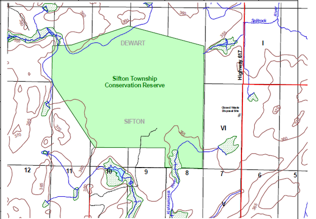
Map: Location of Sifton Township Conservation Reserve
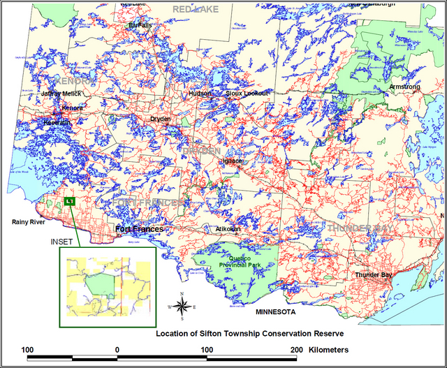
Enlarge Map: Location of Sifton Township Conservation Reserve
Appendix A Permitted Uses List
Land use activity for Sifton Township Conservation Reserve
Those uses and management activities not listed in the following table are governed by existing Conservation Reserve policy. Management direction is elaborated in the Statement of Conservation Interest. Any new uses, and commercial activities associated with them, will be considered on a case by case basis, and must pass a test of compatibility to be acceptable. Compatibility is normally determined through a planning process.
Commercial activities
| Activity | Permitted | Guidelines |
|---|---|---|
| Aggregate extraction: | No | |
| Bait fishing - Existing: | Yes | Existing use permitted to continue, unless there are significant demonstrated conflicts. |
| Bait fishing - New: | Maybe | New operations can be considered, subject to the "test of compatibility". |
| Commercial fishing - Existing: | Yes | Existing use permitted to continue, unless there are significant demonstrated conflicts. |
| Commercial fishing - New: | Maybe | New operations can be considered, subject to the "test of compatibility". |
| Commercial fur harvesting - Existing: | Yes | Existing use permitted to continue, unless there are significant demonstrated conflicts. Existing trap cabins can continue; new cabins are not permitted. |
| Commercial fur harvesting - New: | Maybe | New operations can be considered, subject to the "test of compatibility". |
| Commercial hydro development: | No | |
| Commercial timber harvest | No | |
| Commercial tourism - Existing: | Yes | Existing authorized facilities can continue, unless there are significant demonstrated conflicts. |
| Commercial tourism - New: | Maybe | New tourism facilities can be considered during the planning for an individual reserve. |
| Bear hunting by nonresidents (guided) - Existing: | Yes | Existing authorized operations permitted to continue. |
| Bear hunting by nonresidents (guided) - New: | No | New operations not permitted. |
| Outfitting services existing: | Yes | Existing authorized operations permitted to continue. |
| Outfitting services - New: | Maybe | New operations can be considered during the planning for an individual reserve. |
| Outpost camps - Existing: | Yes | Existing authorized operations permitted to continue. |
| Outpost camps - New: | Maybe | New operations can be considered during the planning for an individual reserve. |
| Resorts/lodges - Existing: | Yes | Existing authorized operations permitted to continue. |
| Resorts/lodges - New: | Maybe | New tourism facilities can be considered during the planning for an individual reserve. |
| Energy transmission and communications corridors - Existing: | Yes | These facilities should avoid conservation reserve lands wherever possible. |
| Energy transmission and communications corridors - New: | No | |
| Food harvesting (commercial) - Existing: | Maybe | Written authority required. |
| Food harvesting (commercial) New: | Maybe | Written authority required. |
| Mineral exploration and development: | No | |
| Peat extraction: | No | |
| Wild rice harvesting - Existing: | Yes | |
| Wild rice harvesting - New: | Maybe |
Land and resource management activities
| Activity | Permitted | Guidelines |
|---|---|---|
| Crown land disposition - Private use: | Maybe | Sale of lands is not permitted, except for minor dispositions in support of existing uses (e.g., reconstruction of a septic system). Renewals of existing leases and land use permits are permitted. Requests for transfer of tenure will be considered in the context of the Statement of Conservation Interest or Resource Management Plan. New leases or land use permits permitted for approved activities. Tourism facilities can apply to upgrade tenure from LUP to lease. |
| Crown land disposition - Commercial use: | Maybe | Sale of lands is not permitted, except for minor dispositions in support of existing uses (e.g., reconstruction of a septic system). Renewals of existing leases and land use permits are permitted. Requests for transfer of tenure will be considered in the context of the Statement of Conservation Interest or Resource Management Plan. New leases or land use permits permitted for approved activities. Tourism facilities can apply to upgrade tenure from LUP to lease. |
| Fire suppression: | Yes | Fire suppression policies are similar to adjacent Crown lands, unless alternative fire policies have been developed through a planning process. |
| Fish habitat management: | Maybe | |
| Fish stocking: | Maybe | Conservation Reserves policy indicates that "featured species management" may be permitted. |
| Insect/disease suppression: | Maybe | |
| Inventory/monitoring | Yes | |
| Personal use permits for wood harvesting: | Maybe | Existing permits may continue on an interim basis for properties that do not have road access. The long term status will be determined through management planning. |
| Prescribed burning: | Maybe | May be carried out to simulate natural fire. Subject to a planning process. |
| Roads (resource access) - Existing: | Yes | Existing roads can continue to be used. Continued use will include maintenance and may include future upgrading. |
| Roads (resource access) - New: | No | New roads for resource extraction will not be permitted, with the exception of necessary access to existing forest reserves for mineral exploration and development. |
| Vegetation management: | Maybe | Conservation Reserves policy indicates that Featured Species Management and Natural Systems Management may be permitted. Vegetation management can be considered in a planning process. |
| Wildlife population management: | Maybe |
Science, education and heritage appreciation
| Activity | Permitted | Guidelines |
|---|---|---|
| Collecting: | No | |
| Historical appreciation: | Yes | |
| Nature appreciation: | Yes | |
| Photography and painting: | Yes | |
| Research: | Yes | |
| Wildlife viewing: | Yes |
Recreation activities and facilities
| Activity | Permitted | Guidelines |
|---|---|---|
| All-terrain vehicle use - On Trails: | Yes | Existing use permitted to continue where it does not adversely affect the values being protected. ATV use not permitted except for direct retrieval of game. |
| All-terrain vehicle use - Off trails: | No | Existing use permitted to continue where it does not adversely affect the values being protected. ATV use not permitted except for direct retrieval of game. |
| Campgrounds: | Maybe | |
| Horseback riding (trail): | Yes | Existing use on trails permitted. |
| Hunting: | Yes | |
| Mountain bike use: | Yes | Existing use on trails permitted. |
| Motor boat use - Commercial: | Yes | |
| Motor boat use - Private: | Yes | |
| Non-motorized recreation travel: | Yes | |
| Private recreation camps (hunt camps) - Existing: | Yes | Existing camps permitted to continue, and may be eligible for enhanced tenure, but not purchase of land. |
| Private recreation camps (hunt camps) - new: | No | |
| Rock climbing: | Maybe | |
| Snowmobiling on trails: | Yes | Existing use permitted to continue where it does not adversely affect the values being protected. |
| Snowmobiling off trails: | Maybe | Off trails not permitted, except that snowmobiles maybe used for direct retrieval of game. |
| Sport fishing: | Yes | |
| Trail development: | Maybe | Development of trails for a variety of activities (e.g., hiking, cross-country skiing, cycling, horseback riding, snowmobiling) can be considered as part of planning for an individual reserve. |
Note: The policies outlined in this table do not supersede any Aboriginal or treaty rights that may exist, or other legal obligations.
Source: OLL Land Use Strategy, Table 4, and Conservation Reserves Policy.
Management of this conservation reserve is carried out within the context of conservation reserve policy as amended by the policies for new conservation reserves outlined in the OLL Land Use Strategy.
Source of direction:
LUS (1999)
Fort Frances District Fisheries Management Plan (1987)
Appendix B Survey checksheets
Recreation Inventory Checklist
| Name | Sifton Township Conservation Reserve |
|---|---|
| Map name | Arbor Vitae |
| NTS Number | 52D/16 |
| UTM reference | 15 4125/54184 |
| OBM Number | 2015410054100 |
| Latitutde | 48 55' 00" |
| Longitude | 94 11' 30" |
| Area (ha) | 712 |
| Ownership | Crown |
| MNR Region | Northwest |
| MNR District | Fort Frances |
| Park Zone | Northwest |
| County | N/A |
| Township | Sifton/Dewart |
Recreation
- E08 Wetland Vegetation
- W00 Wildlife, general
- E03 Coniferous
- J05 Organic
Recreation
- n05 Nature Study
- h00 Hunting/Trapping - Hunting - General
- n03 Identifying Wildlife
- q10 Birdwatching
- n06 Photography
| Recreation | Features | Rating (Very High, High, Moderate, Low) |
|---|---|---|
| Most Scarce Feature: | 3 | |
| Feature Scarcity: | Moderate | |
| Most Unique Feature: | 1 | |
| Activity Attraction Capability: | Low | |
| Scenic Attractiveness: | Low | |
| Geographic Significance: | Low | |
| Feature Significance: | ||
| Most Sensitive Feature To Recreation | 1 | |
| Feature Sensitivity To Recreation Use: | High | |
| Most Sensitive Feature To Resource | 1 | |
| Feature Sensitivity To Resource Development: | High | |
| Cultural/Historic and Archaelogical Features: | N/A |
Comments: The site has limited potential for most traditional recreational activities, being dominated by swamp and bog. Activities which could be pursued such as hunting, bird and wildlife viewing or botany, are hampered by the difficulties associated with access.
Date compiled: November 28, 2001
Compiler: John Munroe
Source: Recreation Resource Inventory Stadndards and Proceedures DRAFT REPORT, Gov. of British Columbia, Ministry of Forests Range, Recreation and Forests Practices Branch, March 1995.
Ontario Ministry of Natural Resources, Ontario Parks
300 Water Street, Peterborough, Ontario K9J 8N1
Earth Science Inventory Checklist
| Name | Sifton Township Conservation Reserve |
|---|---|
| Map name | Arbor Vitae |
| NTS Number | 52D/16 |
| UTM reference | 15 4125/54184 |
| OBM Number | 2015410054100 |
| Latitutde | 48 55' 00" |
| Longitude | 94 11' 30" |
| Elevation - Max | 360 |
| Elevation - Min | 355 |
| County | N/A |
| Concession | VI ; I |
| Area (ha) | 712 |
| Ownership | Crown |
| Area Photos Year-Roll-Flight-Line Number |
95-8-4830B-165, 166, 167 95-17-4831C-61, 62, 63 |
| MNR Region | Northwest |
| MNR District | Fort Frances |
| Park Zone | Northwest |
Map of Sifton Township Conservation Reserve boundary
Enlarge map of Sifton Township Conservation Reserve boundary
Earth science features
Extensive areas of wetlands and deep overburden make access to and direct observation of geological features difficult, and much of the information is therefore inferred: glaciolacustrine and morainal deposits; extensive peat deposits; felsic igneous rocks (Sabaskong Batholith); complex, deep, sandy carbonate-rich glaciolacustrine sediments and carbonate-rich and acidic tills.
Significance
The peatland ecology supports a unique variety of flora and fauna. The drainage into three river systems has created a pattern of treed and open fen, swamp and raised bog ,visible primarily from the air. Forming the headwaters of the Little Grassy, Kishkakoesis and Splitrock River systems, the site is considered of Regional significance, although it is not the geological features directly which lead to this conclusion.
Sensitivity
Drainage of adjacent lands for agricultural and other purposes may have an influence on the rate of decomposition or volatility in the peat deposits, change drainage patterns and effect ecology. No significant undertakings of this sort currently affect the site.
Recommendations
The active co-operation of adjacent property owners and roads authorities in limiting drainage of wetlands should be sought.
Major references
Bajc, A. F. (1991); Fenton, M. M., Moran, S. R., Teller, J. T. and Clayton, L. (1983); Johns, G.W. (1988); Jones, P. (1996); Northland Associates Ltd. (1984); Teller, J.T. and Bluemle, J. P. (1983); Zoltai, S.C. (1961).
Date compiled
December 2001
Compiler
John Munroe, District Planner, Fort Frances District.
Natural Heritage Area – Life Science Checksheet
| Name | Sifton Township Conservation Reserve |
|---|---|
| Map name | Arbor Vitae |
| Map Number | 52D/16 |
| UTM reference | 15 4125/54184 |
| County | N/A |
| Latitutde | 48 55' 00" |
| Longitude | 94 11' 30" |
| NAD | 83 |
| Minimum Altitude | 355 m. |
| Maximum Altitude | 360 m. |
| Locality | NW of North Branch, W of Highway #617. Approximately 23 kilometers north of the town of Stratton |
| Township | Sifton/Dewart |
| Area | 712 hectares |
| Ownership | Crown |
| MNR Region | Northwest |
| Ecoregion and Ecodistrict | 5S2 |
| Area Photographs Year-Roll-Flight-Line Number |
1995-08-4830B-164, 165, 166; 1995-17-483C-61, 62, 63 |
| Land form unit(s) | |
| MNR District | Fort Francis |
Map of Sifton Township Conservation Reserve boundary
Enlarge map of Sifton Township Conservation Reserve boundary
Physical and biological features
Representation
Primary feature is a raised bog, which is further differentiated into treed and open bog features. Surrounding wetland and upland forested features including swamp and fen ecosites are also included within the boundaries. The primary feature may be subdivided into four distinct sections representing drainage; the southeast section drains into a tributary of the Pinewood River; the southwest section drains into a second tributary of the Pinewood River; the northeast section drains into a tributary of the Splitrock River; and the northwest section drains into a tributary of the Grassy River. Between the drainage divides within the primary feature lie the treed portions of the raised bog, with the feature becoming open bog radiating outwards. The bog feature grades into narrow bands of fen along the margins closer to the outflows, as water movement becomes more pronounced. This in turn grades into treed swamp features, particularly in the northern drainage channels. Upland features around the periphery of the site are captured mainly due to practical considerations associated with defining the boundary of the protected area.
The site was initially identified by T. Noble in his gap analysis report as part of MNR's Nature’s Best initiative as a candidate for protection. It was recommended as an representative example of a raised bog feature, relatively rare in the northwest. Subsequent Forest Resources Inventory identified the primary features as fen, but field investigation confirmed T. Nobles assessment as correct, with no evidence found of fen indicators throughout most of the primary wetland ecosites.
Condition
The boundaries of the site as shown have been proposed to capture the wetland features and exclude areas indicating past human disturbance. The main features represented are therefore largely undisturbed. Several game trails, created through dear usage as travel corridors corresponding to the peripherys of the main features, particularly running east-west along the northern edge of the bog, were the only disturbances identified. A single trail runs in a northwesterly-southeasterly direction through the main treed bog portion. These trails represented localized compaction of the sphagnum hummocks, creating furrows which indicated continuous and significant use by deer. They are easily identified on aerial photographs.
Although a former waste disposal site formerly operated by MNR exists to the east of the site of the area, along Highway #617, the site has been closed and a significant treed buffer exists between it and the wetland feature. It is not anticipated that this represents any impact on the protected area.
Surrounding private farmlands represent a variety of human activities, but due to the nature of the site as a headwater, most of these lands are located "downstream", and therefore should not represent significant potential impacts on the features of the site.
A single east-west survey line was cut through the centre of the bog feature along the boundary between Sifton and Dewart Townships. It is identifiable on aerial photographs, but, due to its age, is not readily identifiable on the ground.
Diversity
The ecosites identified within the boundaries of the protected area include:
Raised bog features
Ecological considerations
Elevated hummocks subject to compaction. Trails through bog features in particular should be discouraged.
Special features
- peatland is situated on a drainage divide for three stream systems (i.e., Kishkakoesis, Splitrock, Grassy headwaters), draining southerly into the Pinewood and Rainy River; northerly into Sabaskong Bay; and westerly into Lake of the Woods, respectively
- "classic" raised (i.e., domed) bog belonging to the crested ridge type with drainage seeps radiating laterally from the ridge crest
Major information sources
Forest Resources Inventory - Crossroute Forest (2000); Gap Analysis (Nature’s Best) Recommendation - T. Noble (1997); Field reconnaisance Survey (Munroe/Baycroft - 2001).
Significance level (provincial/regional/local) and brief summary of major representative values
Regional. Raised bogs of this type are relatively common in northeastern Ontario but rare in northwestern Ontario.
Date Compiled
17/08/2001
Compiler
John E. Munroe, District Planner
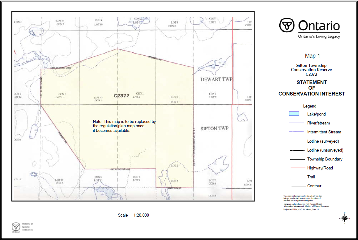
Appendix C Maps
Map 1: Sifton Township Conservation Reserve
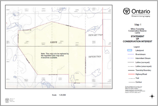
Enlarge Map 1: Sifton Township Conservation Reserve
Map 2: Sifton Township Conservation Reserve Waste Disposal Site
Enlarge Map 2: Sifton Township Conservation Reserve Waste Disposal Site
Map 3: Sifton Township Conservation Reserve Recretional Survey
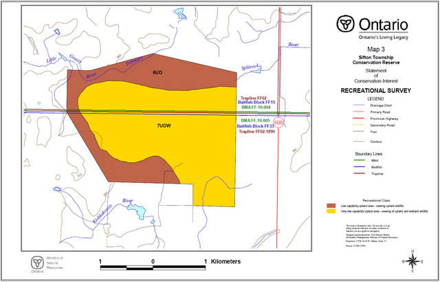
Enlarge Map 3: Sifton Township Conservation Reserve Recretional Survey
Map 4: Sifton Township Conservation Reserve Lifescience Survey Ecosites
Enlarge Map 4: Sifton Township Conservation Reserve Lifescience Survey Ecosites
Map 5: Sifton Township Conservation Reserve Lifescience Survey Forest Cover

Enlarge Map 5: Sifton Township Conservation Reserve Lifescience Survey Forest Cover
Map 6: Sifton Township Conservation Reserve Earth Science Surficial Geology
Enlarge Map 6: Sifton Township Conservation Reserve Earth Science Surficial Geology
Map 7: Sifton Township Conservation Reserve Lifescience Survey Landforms
Enlarge Map 7: Sifton Township Conservation Reserve Lifescience Survey Landforms
Appendix D Forest stand listings
Sifton Township Conservation Reserve (C2372) Forest Resources Inventory - stand listings
| Stand | Age | Working Group | Area | Year Update | Height | Stkg. | Site Class | Species composition | Prime Ecosite | Mapsheet |
|---|---|---|---|---|---|---|---|---|---|---|
| 26850 | 80 | 11 | 30 | 2000 | 9 | 0.8 | 3 | SB 9L 1 | 35 | 154105410 |
| 17870 | 80 | 11 | 23 | 2000 | 14 | 0.8 | 1 | SB 9PO 1 | 31 | 154105410 |
| 12910 | 0 | 0 | 0 | 2000 | 0 | 0 | 0 | 154105410 | ||
| 22870 | 80 | 11 | 31 | 2000 | 7 | 0.7 | 4 | SB 8L 2 | 36 | 154105410 |
| 10860 | 70 | 18 | 12 | 2000 | 13 | 0.7 | 1 | L 6SB 3CE 1 | 36 | 154105410 |
| 40880 | 90 | 11 | 2 | 2000 | 9 | 0.6 | 3 | SB 0 | 35 | 154105410 |
| 33820 | 0 | 0 | 171 | 2000 | 0 | 0 | 0 | 154105410 | ||
| 30870 | 60 | 11 | 7 | 2000 | 7 | 0.7 | 3 | SB 9L 1 | 35 | 154105410 |
| 15840 | 75 | 11 | 21 | 2000 | 5 | 0.5 | 4 | SB 8L 2 | 36 | 154105410 |
| 16820 | 80 | 11 | 27 | 2000 | 6 | 0.6 | 4 | SB 0 | 35 | 154105410 |
| 34840 | 60 | 11 | 7 | 2000 | 7 | 0.7 | 3 | SB 9L 1 | 35 | 154105410 |
| 18780 | 80 | 11 | 30 | 2000 | 7 | 0.8 | 4 | SB 0 | 35 | 154105410 |
| 13800 | 70 | 18 | 9 | 2000 | 11 | 0.7 | 2 | L 5CE 3AB 1SB 1 | 36 | 154105410 |
| 39780 | 90 | 11 | 7 | 2000 | 14 | 0.6 | 2 | SB 7L 2AB 1 | 36 | 154105410 |
| 23770 | 0 | 0 | 50 | 2000 | 0 | 0 | 0 | 154105410 | ||
| 41780 | 50 | 33 | 2 | 2000 | 19 | 1 | 2 | PO 8AB 1B 1 | 29 | 154105410 |
| 16750 | 65 | 33 | 21 | 2000 | 22 | 0.9 | 2 | PO 8B 1SW 1 | 29 | 154105410 |
| 28760 | 80 | 11 | 11 | 2000 | 9 | 0.7 | 3 | SB 7L 3 | 36 | 154105410 |
| 41770 | 95 | 17 | 1 | 2000 | 8 | 0.7 | 4 | CE 5SB 2AB 1L 1PO 1 | 37 | 154105410 |
| 18740 | 80 | 11 | 7 | 2000 | 11 | 0.7 | 2 | SB 5CE 3L 2 | 36 | 154105410 |
| 39750 | 80 | 11 | 24 | 2000 | 15 | 1 | 1 | SB 0 | 35 | 154105410 |
| 35730 | 75 | 11 | 11 | 2000 | 6 | 0.6 | 4 | SB 9L 1 | 35 | 154105410 |
| 33730 | 85 | 11 | 8 | 2000 | 14 | 0.6 | 1 | SB 7L 2PO 1 | 36 | 154105410 |
| 34700 | 0 | 0 | 10 | 2000 | 0 | 0 | 0 | 154105410 | ||
| 26710 | 80 | 11 | 7 | 2000 | 13 | 0.5 | 2 | SB 8L 2 | 36 | 154105410 |
| 30710 | 30 | 33 | 17 | 2000 | 14 | 1 | 2 | PO 9B 1 | 29 | 154105410 |
| 39710 | 142 | 17 | 4 | 2000 | 9 | 1 | 4 | CE 8B 2 | 37 | 154105410 |
| 41710 | 60 | 33 | 4 | 2000 | 20 | 1 | 3 | PO 6B 2L 1SB 1 | 29 | 154105410 |
| 39670 | 110 | 11 | 15 | 2000 | 11 | 0.7 | 3 | SB 0 | 35 | 154105410 |
| 22710 | 80 | 11 | 1 | 2000 | 11 | 0.7 | 2 | SB 5CE 3L 2 | 36 | 154105410 |
| 23700 | 65 | 33 | 4 | 2000 | 22 | 1 | 2 | PO 8B 2 | 29 | 154105410 |
| 37670 | 0 | 0 | 6 | 2000 | 0 | 0 | 0 | 154105410 | ||
| 40690 | 60 | 11 | 4 | 2000 | 7 | 0.6 | 3 | SB 7L 3 | 36 | 154105410 |
| 34680 | 65 | 33 | 5 | 2000 | 22 | 1 | 2 | PO 8B 2 | 29 | 154105410 |
| 33680 | 30 | 33 | 0 | 2000 | 14 | 1 | 2 | PO 9B 1 | 29 | 154105410 |
| 35670 | 0 | 0 | 6 | 2000 | 0 | 0 | 0 | 154105410 | ||
| 31640 | 65 | 33 | 34 | 2000 | 22 | 1 | 2 | PO 8B 2 | 29 | 154105410 |
| 34630 | 65 | 33 | 9 | 2000 | 22 | 1 | 2 | PO 8B 2 | 29 | 154105410 |
| 36630 | 0 | 0 | 5 | 2000 | 0 | 0 | 0 | 154105410 | ||
| 38630 | 0 | 0 | 10 | 2000 | 0 | 0 | 0 | 154105410 | ||
| 39620 | 110 | 11 | 14 | 2000 | 11 | 0.7 | 3 | SB 0 | 35 | 154105410 |
| 10908 | 55 | 33 | 1 | 2000 | 20 | 0.7 | 2 | PO 5B 2BW 1SB 1SW 1 | 38 | 154105410 |
| 10913 | 0 | 0 | 1 | 2000 | 0 | 0 | 0 | 154105410 | ||
| 21920 | 45 | 20 | 9 | 2000 | 14 | 0.7 | 1 | AB 0 | 38 | 154105410 |
| 22930 | 60 | 33 | 4 | 2000 | 22 | 0.7 | 2 | PO 6B 2SB 1SW 1 | 29 | 154105410 |
| 28930 | 110 | 17 | 4 | 2000 | 11 | 0.7 | 3 | CE 7SB 2L 1 | 37 | 154105410 |
| 18910 | 75 | 11 | 19 | 2000 | 12 | 0.7 | 2 | SB 8L 2 | 36 | 154105410 |
| 36910 | 80 | 18 | 23 | 2000 | 16 | 0.7 | 1 | L 6PO 2AB 1SB 1 | 36 | 154105410 |
| 33920 | 110 | 17 | 1 | 2000 | 11 | 0.7 | 3 | CE 7SB 2L 1 | 37 | 154105410 |
| 31910 | 80 | 11 | 10 | 2000 | 13 | 0.6 | 2 | SB 7L 3 | 36 | 154105410 |
| 14910 | 65 | 33 | 10 | 2000 | 23 | 0.8 | 2 | PO 6B 2AB 1SB 1 | 29 | 154105410 |
| 30900 | 75 | 11 | 25 | 2000 | 6 | 0.8 | 4 | SB 8L 2 | 36 | 154105410 |
Appendix E Sifton Township Conservation Reserve C2372 factsheet
June, 2001
Background
On July 16, 1999, the Ontario Government released the Ontario’s Living Legacy Land Use Strategy to guide the planning and management of Crown lands in central and parts of northern Ontario. A major part of the Ontario’s Living Legacy Land Use Strategy was a government intent to establish 378 new protected areas. This commitment marks the biggest expansion of provincial parks and conservation reserves in Ontario’s history.
The proposed Sifton Township Conservation Reserve is part of this significant expansion of Ontario’s protected areas system.
Size and location
The Sifton Township site is located in the Rainy River District, approximately 23 kilometres north of the town of Stratton. This small site is not road accessible but Highway 600 is located within 750 metres of the eastern boundary. The area surrounding this reserve is predominately patented land. The Sifton Township site is approximately 712 hectares in size.
Area highlights
The proposed Sifton Township Conservation Reserve is a unique area that contains a raised bog. A raised bog is formed when peat accumulates at the centre to a greater degree than at the edges resulting in a cross section resembling an inverted saucer. This wetland feature is very unique to northwestern Ontario. The Sifton Township site supports many wetland/bog plant species, birds of prey, and songbirds. Around the periphery, visitors may be fortunate to view deer, bear and other small mammals. Due to the wet nature of this area, access within the site is limited and difficult.
Land use intent
Conservation reserves are areas of Crown land set aside by regulation under the Public Lands Act. Conservation reserves complement provincial parks in protecting representative natural areas and special landscapes. Most recreation activities (e.g. hiking, skiing, tourism related uses, nature appreciation) that have traditionally been enjoyed in the area will continue, provided that these uses do not impact on the natural features needing protection. Hunting and fishing is permitted within most new conservation reserves proposed through Ontario’s Living Legacy.
Commercial timber harvesting, mining, aggregate extraction and commercial hydroelectric development are prohibited in conservation reserves. New private access roads and new resource access roads are not permitted in conservation reserves unless a prior commitment has been made.
Where there are existing Aboriginal and treaty rights, the establishment of this conservation reserve does not extinguish these rights.
Next steps
The Land Use Strategy established the Ministry’s intent to add these Crown land areas to Ontario’s protected areas system following the extensive public consultation associated with the Ontario’s Living Legacy and Lands for Life land use planning initiatives between 1997 and 1999. Prior to the finalization of the boundary of this Conservation Reserve proposed for regulation under the Public Lands Act, the Ministry is inviting public comment from June 15 - July 15, 2001 on the proposed boundary from all potentially affected stakeholders. The Ministry is committed to ongoing consultation First Nations potentially affected by OLL decisions.
In the interim, the area has been withdrawn and protected from resource extraction activities such as timber harvesting, hydroelectric development, aggregate extraction and new mineral exploration.
In the future and subject to the intended regulation of the area as a conservation reserve, the Ministry of Natural Resources will provide long term management direction for this area. Depending upon the complexity of issues within this conservation reserve, management direction may take the form of a simple Statement of Conservation Interest or a more detailed Resource Management Plan. The public will be invited to participate in the preparation of management plans. Please let us know if you would like to be notified directly of this opportunity. Planning, management and the uses permitted within this conservation reserve will be consistent with the commitments of the Ontario’s Living Legacy Land Use Strategy and Conservation Reserves Policy and Procedure (1997).
For more information
For further information on the Sifton Township Conservation Reserve, please contact John Munroe, Ministry of Natural Resources, 108 Saturn Ave., Atikokan, Ontario, P0T 1C0, phone (807) 597-6971, extension 241, Fax: (807) 597-6185. You may also visit the Ministry’s Internet web site at www.ontarioslivinglegacy.com [link no longer active] for information on Ontario’s Living Legacy.
Appendix F Photographs
Figure 2: Satellite image of Sifton Township Conservation Reserve.
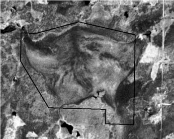
Figure 3: Aerial photograph of raised bog feature - Sifton Township Conservation Reserve.
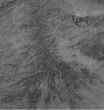
Figure 4: Aerial photograph showing distinct game trails - Sifton Township Conservation Reserve.
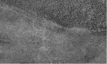
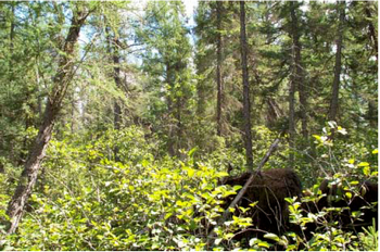
Figure 5: Photograph of ES40 Treed Fen - Sifton Township Conservation Reserve.
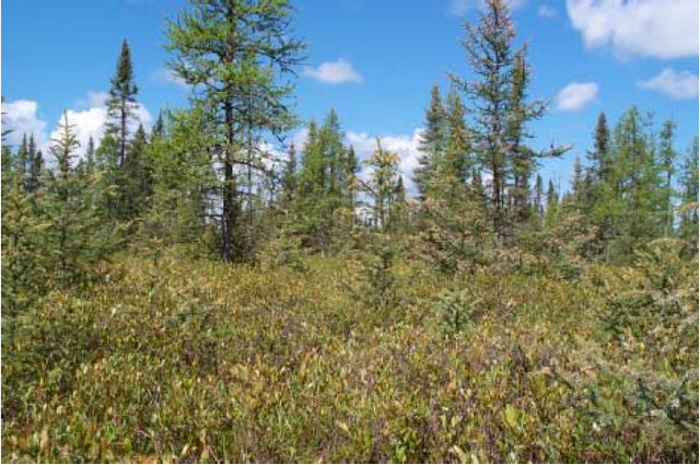
Figure 6: Photograph of ES34 Treed Bog - Sifton Township Conservation Reserve.
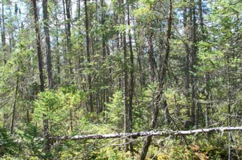
Figure 7: Photograph of ES36 Intermediate Swamp - Sifton Township Conservation Reserve.