Silent Lake Provincial Park Management Plan
This document provides policy direction for the protection, development and management of Silent Lake Provincial Park and its resources.
Approval statement
Silent Lake Provincial Park was established in 1975 to provide outstanding outdoor recreation opportunities in the popular Haliburton Tourist area. In developing the Park, attention was given to preserving the natural values of the area and retaining its tranquility and solitude. The Park offers both recreational campers and wilderness enthusiasts an unspoiled environment together with easy access and modern facilities. Silent Lake Provincial Park provides traditional drive-in campsites as well as walk-in sites. In winter cross-country skiing and ice fishing can be enjoyed by the public.
We are pleased to approve the Silent Lake Provincial Park Management Plan, as official policy for the management and development of this park. The plan reflects this Ministry’s intent to protect natural and cultural features of Silent Lake Park and maintain and develop high quality opportunities for outdoor recreation and heritage appreciation for both residents of Ontario and visitors to the Province.
Regional director
Algonquin region
Director parks and recreation areas branch
1.0 Introduction
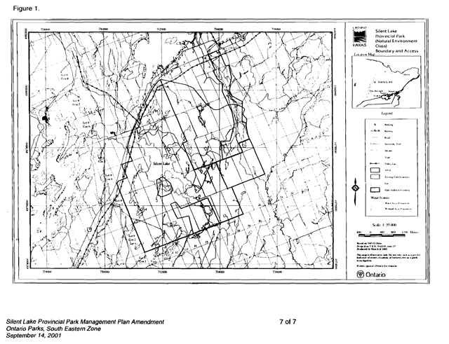
Silent Lake Provincial Park is located in the southern portion of Cardiff Township, County of Halliburton. Highway 28 runs along its north and northwest boundary providing good road access from the large urban centres of Peterborough, Oshawa and Toronto to the south (Figure 1). The Park lies 80 kilometers north of Peterborough, 216 kilometres northeast of Toronto and 24 kilometres south of Bancroft.
The Park, a Natural Environment class park, covers an area of 1,450 hectares offering a year - round threshold wilderness experience. The 125 hectare lake known as Silent Lake has pine studded rocky shores and possesses the solitude of a northern lake. Construction initiated on Silent Lake Provincial Park in 1966 and continued until 1978. The Park was first opened to the public in the summer of 1975, rut was not put into regulation until 1977.
All development has taken place in the northern portion of the Park leaving the remainder, approximately 60 percent of the Park area, in a natural state. The Park contains 167 campsites of which 45 are walk-in and 122 are car campsites divided into three separate camping areas and two campgrounds respectively. Each of the three walk-in camping areas contains vault toilets, water faucets and a central parking lot. Both campgrounds are serviced by vault toilets, a centrally located comfort station containing flush toilets, showers and laundry facilities, centralized garbage facilities and water faucets. All of the camping facilities are located in the northeastern corner of the Park; the campsites developed with privacy and natural setting as the criteria. A central wood yard provides firewood needs.
A small day use area located at the north end of Silent Lake contains a parking lot, floating docks, vault toilets, and a swimming beach.
The maintenance area east of the campgrounds consists of a staff quarters, a four-bay maintenance building and superintendent’s office, fuel storage building, and a four-bay cold storage building.
Activities offered in the Park include lake trout, large and smallmouth bass fishing, canoeing (motorboat ban), 11 kilometres of hiking trails and 40 kilometres of cross-country ski trails.
Silent Lake Provincial Park is located within the Grenville Province of the Precambrian Shield, 48 kilometers north of its junction with younger sedimentary rocks of southern Ontario. Good examples of glacial abrasion is found on the granitic rocks along the shoreline of Silent Lake. Bedrock geology of this area is complex and several important mineral deposits, especially uranium, are found immediately north of the Park. Quartz-sillimanite modules found in the Park’s bedrock are unique to Ontario and the best developed in Canada.
Topography is broken and rolling, and in places precipitous, especially in the vicinity of the shore at the southern end of the lake and in sane higher backshore areas. Swamps and wetlands are common. Ecologically the area lies in the Great Lakes - St. Lawrence Mixed Forest zone. Historically the Park area has been selectively cut numerous times, though never clear-cut or completely burnt over. This can be shown clearly by the fact that today some 95 percent of the Park area is forested.
The general climate of the Park area is classed as typical Humic Continental with warm summers and cold snowy winters, ideal for year-round outdoor recreation activities.
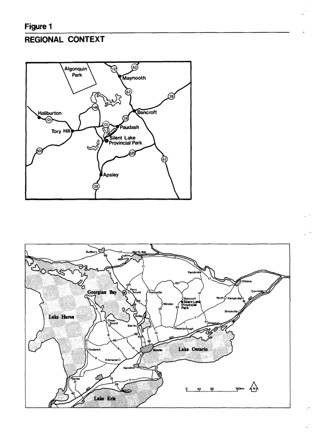
Enlarge this regional context map for Silent Lake Provincial Park (PDF)
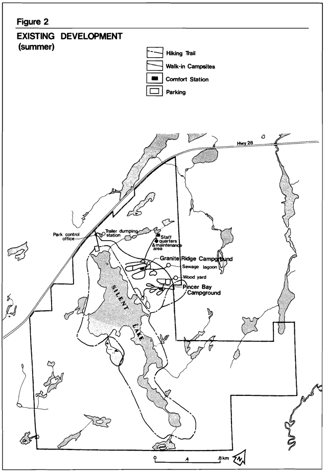
Enlarge this map of existing summer developments for Silent Lake Provincial Park (PDF)
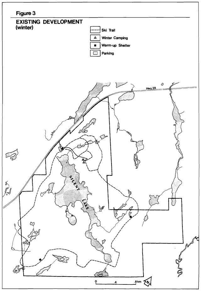
Enlarge this map of existing winter developments for Silent Lake Provincial Park (PDF)
2.0 Summary of significant issues
Silent Lake Provincial Park’s development followed guidelines set out in site and development plans and a preliminary management plan. For this reason no major problems in design have occurred.
However, four areas require improvement:
- A permanent structure combining a summer picnic shelter and winter warm-up shack is needed to provide day users protection from inclement or unexpected weather conditions.
- The walk-in campsites located adjacent to Granite Ridge campground have proved inappropriate. Consideration should be given to converting some of these campsites into a small car campground.
- With present winter fishing pressure and the noticeable decrease in fishing success, a fish management plan for the Park is required.
- To meet future demand for car camping, a third campground should be considered and contain facilities similar to those in the existing campgrounds.
3.0 Classification
Silent Lake Provincial Park will continue to be classed as a Natural Environment Park.
4.0 Park goal
Silent Lake Provincial Park will provide a variety of quality, low intensity threshold natural environment recreation experiences on a year 'round basis, compatible with Provincial Park Policy, the park resources and land capability.
5.0 Park objectives
Provincial Natural Environment Parks contribute to the achievement of all four established overall objectives of the Ontario Provincial Park System.
5.1 Protection
To protect a system of provincially significant natural environments incorporating natural, cultural and recreational features.
Silent Lake Park is the only Natural Environment Park in the Bancroft district. Provincially significant earth and life sciences features are found within the park. By ways of development and management strategies, significant earth and life sciences features such as the quartz sillimanite nodules and the upland and lowland habitats of the three other nature reserves will be protected.
5.2 Recreation
- To provide day use opportunities in areas of recreation potential associated with natural environments.
- Silent Lake will provide opportunities for hiking, boating, fishing, swimming, winter cross-country skiing and other healthfu1 and enjoyable outdoor activities on a seasonal basis.
- The Park’s existing recreation opportunities (7,000 picnicking, 10,000 swimming, 36,000 camping opportunities) contribute to the achievement of the recreation target as presented in the Bancroft District Land use Guidelines.
- To provide facility-based camping opportunities in natural environments and in associated areas of outstanding recreational potential.
Silent Lake will be developed and operated to provide visitors contact with fellow recreationists in a balanced, natural environment.
To provide in the natural environment opportunities for back-country travel and camping experiences.
The recreation experience will be characterized by solitude, challenge, and personal integration with nature derived from relatively unmanipulated landscapes of the Park.
5.3 Heritage appreciation
To provide opportunities for unstructured individual exploration and appreciation of the natural environment heritage of Ontario.
Individual exploration and appreciation will be encouraged to the greatest extent compatible with and complimentary to preservation of natural environments, earth and life science features and historical resources of the Park.
To provide opportunities for exploration and appreciation of natural and cultural environments through interpretation and education based upon the character and significance of Natural Environment Parks.
Silent Lake Park will provide interpretive and educational programs c reflect the diversity of features and resources of a natural environment park to be directed to the widest possible user spectrum.
5.4 Tourism objective
To provide Ontario residents and out-of- province visitors with opportunities to discover and experience distinctive regions of the Province.
Silent Lake Park will provide day use and camping opportunities for travellers through Ontario, as well as destination camping opportunities for those attracted from considerable distances.
Silent Lake’s existence in the tourism industry generates $856,256 worth of expenditures and supports 16 jobs in Ontario’s economy.
6.0 Zoning
Land within a Natural Environment Park is zoned to recognize the significance of resources, management inplications and capacity for use.
Natural Environment Parks always include Natural Environment and Development Zones, and may also include Wilderness, Nature Reserve, Historical and Access Zones. Silent Lake Park has three zones - Development, Natural Environment and Nature Reserve.
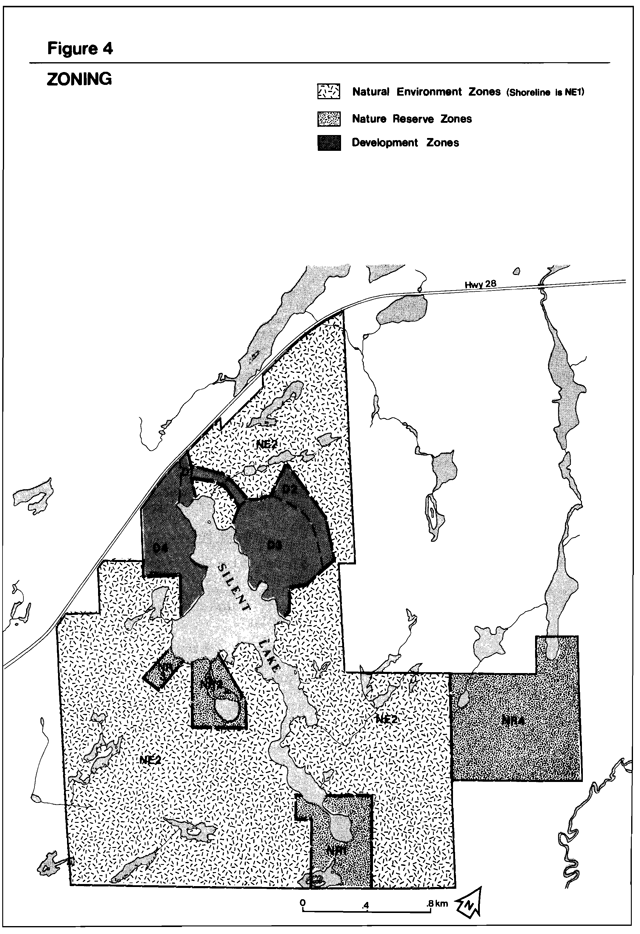
Enlarge this zoning map of Silent Lake Provincial Park (PDF)
6.1 Nature Reserve Zones (233.8 ha)
These zones include significant earth and life science features which require protection distinct from that in adjacent zones.
Development is limited to trails, necessary signs, minimal interpretive facilities for research and management where such development will not harm the natural values to be protected.
There are four Nature Reserves in Silent Lake Park (Figure 3).
NR-1 The Third Silent Lake
This zone (50 hectares) surrounds the Third Silent Lake at the south end of the Park. It contains a wide variety of upland and lowland habitats which are of high representative value. A total of 16 vegetative communitites have been identified here. The most significant of these are the bogs and upland forests.
The sphagnum bogs contain a number of rare and unusual species. These include wild orchids, such as the grass pink and rose pogonia, as well as a rare sedge, bog bean and chain fern.
The upland forest surrounding the Third Silent Lake is dominated by stands of sugar maple and white birch. A variety of interesting southern species occur here, including spring wildflowers such as hepatica, toothwort and blue cohash, as well as Christmas fern and rattlesnake fern.
The zone also provides good wildlife habitat. A pair of common loons nest on the lake. The upland forests provide nesting areas for several species of wood warblers, and the wetlands for yellow throats, great blue herons and a number of amphibians.
Adjacent to the third Silent Lake to the west, is an extensive wetland complex including the remainder of Quiet Lake, that should be surveyed, assessed and seriously considered for incorporation into NR1. This area includes significant southern species such as jack-in-the pulpit, Christmas fern and moneywort. These species alone support the status of this area as a nature reserve zone.
NR-2 Lost Lake Bog
Lost Lake is a small lake (36 hectares) with a shoreline ringed by a sphagnum bog mat. Both the lake and bog environments are of high representative value. The bog mat, which is dominated by larch and leatherleaf, supports an interesting flora. A number of uncommon species occur here, such as chain fern, twig rush, bog bean am rose pagonia orchid. Typical bog species, including sundew and pitcher plant, occur here as well.
Wildlife is common in the area. Lost Lake itself supports a population of beaver and otter. Dead standing trees near the edge of the lake provide nesting habitat for great blue herons, wood ducks am pileated woodpeckers.
The site is quite fragile, am should be used for only very limited on-site interpretation.
NR-3 Quartz Sillimanite Nodules
This small zone of 2.8 hectares contains one of two outcroppings of provincially significant quartz sillimanite modules. This earth science feature is unique in Ontario. They are white to light grey in colour and contrast strongly with the bright reddish orange of the matrix rock. The nodules are much more resistant to weathering than the matrix rock which contains them. The nodules appear to be bisquits sitting on the surface of the rock. The size of the nodules varies from 5mm to 30cm in length. The largest ones are the biggest ever described in the literature.
The best nodules outcrop is in an existing campground on the east side of Silent Lake. Because the nodules are more resistant than the matrix rock, they can be easily broken off. The nodules in the campground should not be interpreted for protection purposes.
NR-4 Lowrie Lakes
This zone, the largest of the four (145 hectares) is located just south of the Lowrie Lakes on the east side of the Park. The site is dominated by sugar maple forest, with occasional stands of white birch in the lowlands. Intermittent streams in the valleys support small black ash swamps.
The valleys are composed of 25 different fern species, including narrrow-leaved spleenwort, a fern which is rare in Ontario. This is the only known location of this fern in Algonquin Region.
A rare amphibian, the four-toed salamander, also occurs here. This species is seldom encountered in Ontario and is only the second area in this region where this salamander has been observed.
This area is a prominent asset to the Park and will be treated with special attention. No development will be allowed for the sole purpose of protecting this area’s significant features.
Nature Reserves 1, 3 and 4 would be difficult to locate due to the lack of natural boundaries. These zones will be surveyed and flagged, promoting public awareness of these sensitive areas. Nature Reserve 2 incorporates natural features to facilitate ground location. Signage and/or a park leaflet will provide ample information promoting the sensitivity of these areas.
6.2 Natural Environment Zones (1020 ha)
A Natural Environment Zone includes aesthetic natural landscapes in which minimum development is required to support low-intensity recreational activities.
Development within the Park will be limited to portages, trails and necessary signs for route identification, minimal interpretive facilities where appropriate, and basic facilities to support low-intensity recreation facilities, as well as protecting representative geology and life science features.
6.3 Development Zones (196.3 ha)
This zone will provide the main access to the Park am facilities for a wide range of day use am camping activities. Development zones are a relatively small portion of Natural Environment parks.
There is one development zone in Silent take Park with four sections:
D 1 - park entrance road, park control office, trailer sanitation station, day use area and main park road providing access to the campgrounds and park maintenance buildings.
D 2 - park maintenance area, staff quarters, proposed park office, sewage lagoon and firewood areas.
D 3 - Granite Ridge and Pincer Bay campgrounds.
D 4 - proposed campground on the west side of Silent take.
7.0 Resource Management
The Park’s natural and cultural resources will be managed according to the administrative policies for resource management in Natural Environment parks.
7.1 Vegetation
A vegetation management plan is required. The Plan will maintain a particular kind and quality of vegetation in a given area in the Park. Zones with vegetation progressing through natural succession will need different management techniques from zones where vegetation is maintained at its present stage of natural succession.
Some management practices will produce small quantities of wood as by-products of selective and dead tree removal. The wood, depending on type and quality, can be used for firewood, sawlogs, posts, or other required items within the Park. By this means, small savings in both maintenance and capital costs may be realized. However, it must be remembered that the main purpose of these management techniques is to maintain or create a particular quality of vegetation and not to generate revenue.
Below is a general description of the type of vegetation cover desired for each zone in the Park.
- Development Zone
Vegetation cover in the beach, day use and play areas of the park will be maintained in a park-like setting with a varying aged overstory and replacement trees in a sparse understory.
A mixture of ground cover vegetation and trees will be maintained to screen the maintenance area and sewage lagoon from the park visitor.
The existing vegetation quality will be maintained in the existing and future camping areas. Ground and understory vegetation will be managed to provide and maintain the existing visual buffer for privacy between campsites. - Nature Reserve zone
All the areas designated under this zoning will be allowed to progress through natural succession. - Natural Environment zone
This area designated under this zoning will have a silvicultural program to promote growth of healthy, aesthetically pleasing forest cover similar to that now present.
Natural succession will progress unimpeded. Where safety hazards along trails exist, potentially dangerous trees will be removed in association with brushing operations and routine trail maintenance.
7.2 Wildlife
No hunting will be allowed.
The following restrictions will apply:
- Only nuisance beaver may be trapped as designated and requested by the Park Superintendant.
- Where control is needed, techniques having minimal effects on other components of the Park Environment will be used.
7.3 Fisheries
A fisheries management plan is needed for Silent take Provincial Park. The plan will address such questions: as the lake capable of supporting a naturally reproducing fishery or will it continue to rely on a fish stocking program? Should winter fishing be allowed? If so, how much and how can it be regulated?
The plan will be written and remain in effect until the results meet the requirements of the management plan, the Park Superintendent and Bancroft District Office.
7.4 Fire
Normal methods of fire detection and suppression will be carried out to protect the park resources.
7.5 Insects and disease
Measures for insect and disease control will be permitted, when necessary, to protect visitor health and park values. The Nature Reserve zones will be excluded unless the very values that are being protected by Nature Reserve zoning are being threatened or attacked by insects and/or disease.
the Trent Valley I.ullber and South Shield Agriculture Historic themes, and one can take advantage of the geological features of the area as well as mineral collecting at sites driving distance of the Park.
7.6 Resource extraction
No commercial extraction of resources will be permitted within the Park.
7.7 Water
Water quality will be monitored by the Park’s present water quality sampling program. Any deterioration in the water quality will be investigated by this Ministry. Appropriate action will be taken to maintain water quality and solve the problem.
8.0 Visitor services
Silent Lake is an integral part of a tapestry of life and activity which does not stop at the park boundary. The Park has been visited by Native Indians, farmed, logged, explored for minerals and used for recreation purposes, first as a lodge and then as a Provincial Park.
Silent Lake will be a satellite park to Algonquin Park - the nodal park for this region, and will be operated in accordance with the Park rating Plan. It also has the resources to illustrate the Trent Valley Lumber and South Shield Agriculture Historic themes, and one can take advantage of the geological features of the area as well as mineral collecting at sites driving distance of the Park.
8.1 Public information
Every park, Silent Lake included, will provide a basic level of communicatian. This includes publications (park leaflet, posters) , displays (kiosk showing past sites of historical significance) and personal contact by park staff, providing the following to the park visitor:
- information about the Provincial Park System;
- information about the Park, its facilities, programs, features, rules and regulations;
- information an management messages for the protection of the park environment and conduct expected of the park visitor;
- information on services, facilities and attractions in the local area of the Park;
- an opportunity for the visitor to communicate thoughts and the Park.
8.2 Interpretation
Interpretive programs such as canoeing and back-country camping will provide visitors opportunities to learn and experience the character and significance of the Park and surrounding area. These programs will be based an natural and cultural features of the park landscape.
Self-use facilities such as trails with trail guides, exhibits and displays at park control offices will be provided.
8.3 Education
While school population with convenient access of the Park is relatively small, desired assistance will be provided to any group leader where practical, compatible with and complimentary to park values.
8.4 Recreation
In keeping with the development concept of a threshold wilderness, an introduction to outdoor recreation skills is important. Those of canoeing and back-country camping will be an integral part of the program. When staff, volunteers and recreation clubs skilled in canoeing and cross-country skiing are available, practical introductory courses emphasizing safety and technique will be offered.
8.5 Recreation management
To maintain the Park’s recreational facilities at a high standard of quality, certain management guidelines must be established. Trails, campsites and the beach are three recreation facilities which require attention. The Park Superintendent will identify the guidelines for maintaining these and other facilities and include them in the Operations Plan for the Park.
8.6 Marketing
A marketing plan to attract more visitors to Silent Lake Park throughout is operating seasons will be prepared with the following objectives: to hold present clientele (average length of stay in 1984 2.3 days, up 0.4 since 1980); to attract day users staying at local commercial establishments or using local services; to attract day users from local urban centres and private cottages; to attract campers and day users during low use periods in the midweek (July-August occupancy rate in 1984 - 62 percent, second highest total in 10 years) and shoulder seasons; to increase involvement with the commercial sector by encouraging the park user to avail oneself and take advantage of local tourist services and attractions, and generally stimulate interaction between the Park and the private tourist and commercial sector in the vicinity.
The marketing plan will also incorporate winter day use, applying current information of planning, research and operational/ management functions to attract more visitors. Important objectives would hold present clientele (average length of stay in area 2.5 days, 0.8 days less than Regional average); promote and attract a higher percentage of day users from local urban centre; and enhance Silent Lake’s recreational attributes to local tourist accommodations, in hoping lodgings will expand their seasons to include a potential increasing winter market.
9.0 Development
Development will proceed in accordance with Figure 5 and the following guidelines. In all instances, detailed site plans will be completed and approved in advance of rehabilitation of existing facilities or the development of new facilities. Development projects including the vegetation management plan will be phased according to the Implementation Strategy (Section 11.0) as needed and funding permits. The requirements of the Environmental Assessment Act will be adhered to.
9.1 Day use parking
Major redevelopment of the existing day use parking lot is necessary to accomodate the increasing numbers of day users during winter and summer use. The need for acklitional parking will be considered prior to or in coojunction with aey further development of the day use area.
9.2 Picnic and warm-up shelter
An all-season permanent post and beam structure with removable walls will be built on a site to be determined in the day use area. The building will be secure and insulated well enough to be used as a warm-up facility for skiers and anglers, yet have the flexibility to be utilized as an open air picnic shelter during inclement summer weather. The building will be designed to blend l into its surroundings.
9.3 Granite Ridge campground redevelopment
Due to inconsistent use and a demand for more car campsites, the 22 site walk-in campsite complex located adjacent to Granite Ridge campground will be redeveloped. The 14 sites located near the existing parking lot will be converted into a small car campground.
The remaining 8 sites will remain as walk-in campsites with a new service road and parking lot providing access to these campsites from the main park road. The existing parking lot will be removed.
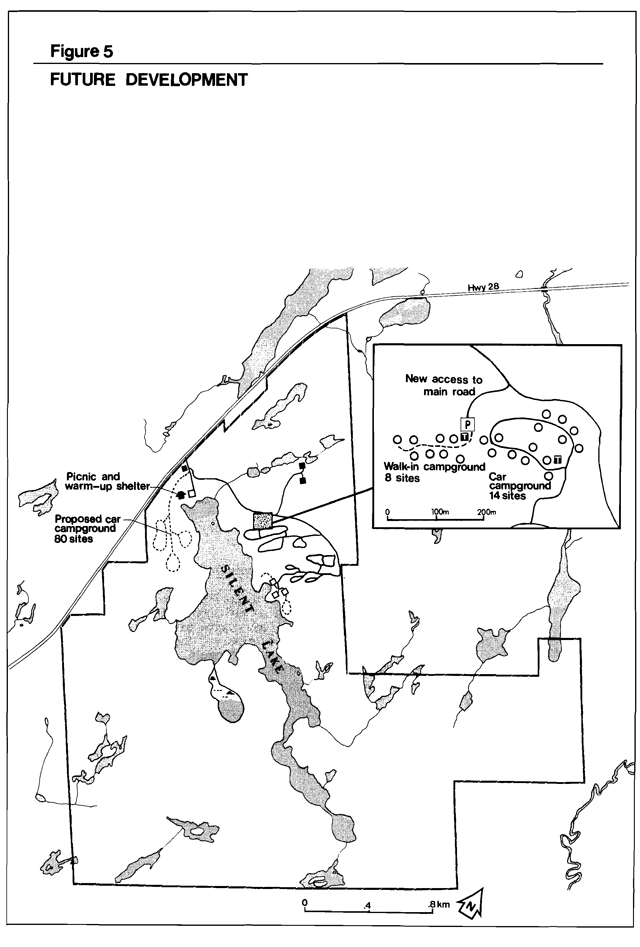
Enlarge this map of future development for Silent Lake Provincial Park
9.4 New campground development
A third campground will be developed on the northwest shore of Silent Lake to meet future demands for car camping opportunities. The area will accommodate 80 car-camping sites. Access will be by a new road constructed to the north of the day use area.
Design criteria for this campground will be consistent with guidelines followed in Granite Ridge and Pincer Bay campgrounds. This new campground will contain facilities similar to those in the existing campgrounds: a centrally located comfort station with showers strategically placed vault toilets and water supply facilities.
10.0 Implementation strategy
The Management Plan will be reviewed not less than every 10 years following its approval and as need arises. Data collection and environmental monitoring will be conducted regularly.
Below is a list of projects that have been previously described in this plan. This list appears in chronological order according to the individual project priority. The number of projects to be completed or partially completed will be based upon the availability and allocation of each year’s capital funding.
| Priority Rating | Project Description |
|---|---|
| 1 | Expansion of the Day Use Parking |
| 2 | Permanent picnic shelter/ warm up shack in day use area |
| 3 | Vegetation Management Plan
|
| 4 | Fisheries Management Plan |
| 5 | Market Management Plan |
| 6 | Redevelopment of Granite Ridge campground walk-in sites |
| 7 | New campground on northwest side of Silent Lake. |
11.0 Public consultation
A preliminary management plan was written and made available to park visitors, adjacent landowners and local township offices to be reviewed and commented on. Very few comments were received. Most are in agreement of what was being proposed.
12.0 References
Cordiner, G.S. A Reconnaissance Earth Science Inventory of Silent Lake Provincial Park, Algonquin Region, Division of Parks, 1977.
Dickson, H.L. A Reconnaissance Life Science Inventory of Silent Lake Provincial Park, Ministry of Natural Resources unpublished report 1979.
Environment Canada. The Tourism and Outdoor Recreation Climate of Ontario, Atmospheric Environment Service, Department of the Environment, Ottawa, 1976.
Ontario Ministry of Natural Resources. Bancroft District Land Use Guidelines, Regional Lands Office, 1983.
Ontario Ministry of Natural Resources. Economic Impact of Provincial Parks in Ontario: A Summary Report, Parks Planning Section, Toronto 1982.
Ontario Ministry of Natural Resources. Ontario Provincial Parks Planning and Management Policies. Parks Planning Section, Toronto, 1978.
Ontario Ministry of Natural Resources. Ontario Provincial Parks Policy, Queen’s Park, June, 1978.
Ontario Ministry of Natural Resources Provincial Parks Statistics, Toronto, Division of Parks, 1974-1984.
Ontario Ministry of Natural Resources Provincial Park User Survey Analysis of Data, Parks Planning Section, Toronto, 1982.
Ontario Ministry of Natural Resources, Provincial Park Winter Survey Statistical Summary, Parks Planning Section, Toronto, 1985.
Minor Amendment Form Silent Lake Provincial Park Management Plan, 1986
(per Policy PM 11.02.03 and Procedure PM 11.02.03, dated August 1, 1994)
September 14, 2001
1.0 Need for amendment
As one of the recommendations of the Ontario’s Living Legacy Land Use Strategy (OLL-LUS), an addition was made to Silent Lake, a Natural Environment class Provincial Park. The OLL-LUS amends some existing park policies; the amended policies will apply to the addition (Appendix I). This minor amendment to the 1986 Silent Lake Provincial Park Management Plan will provide interim management guidelines for the addition until a full Management Plan review is completed.
2.0 Amendments
2.1. Park boundary and zones (Section 1.0 and 6.0 of management plan)
The park boundary in regulation under the Provincial Parks Act was revised on June 23, 2000 (O. Reg. 376/00, Provincial Parks Act). The new boundary encompasses a 169 ha addition on the northeast side of the park (Figure 1) and is described by regulation plan P20 Silent Lake Provincial Park Addition (March 15, 2000). Signs will be erected to identify the addition as part of Silent Lake Provincial Park.
The addition includes Little Lowrie and Lowrie lakes, Moxley Lake, and the intervening Moxley Creek. These lakes are part of a rich marble-based wetland system as described in the Life Science Checksheet. The addition is adjacent to, and hydrologically connected to, Nature Reserve Zone 4 of the existing park. This Nature Reserve Zone was established to protect mature tolerant hardwood forests, and assemblages of unusual plant species.
The addition is described as Natural Environment in the OLL-LUS. The addition will be managed as a Natural Environment zone until further zoning decisions are made during Management Plan review and the addition is addressed in the Silent Lake Provincial Park Management Plan.
2.2. Interim management policies for OLL Additions (Section 7.0 of plan)
Recreational activities
Most activities currently taking place in the addition (Appendix II) will be permitted to continue as directed by the OLL-LUS, although they may be subject to prescriptions determined through future management planning. These activities include sport hunting and fishing, as well as existing commercial bait fish harvesting, commercial fur harvesting, private recreational camps, bear management area (BMA) licences, and authorized all-terrain vehicle (ATV) and snowmobile trail use. No new licences or permits will be issued for the Crown land included in the addition. Future zoning decisions and management planning may influence the permitted uses.
There is an informal campsite located near Moxley Lake on the side of the road. Camping will not be permitted at this location, which also serves as a canoe launch. Users will be directed to the established campsites within the park.
The recreational camp immediately outside the southern boundary of the addition has a fuelwood cutting permit. This permit may be renewed; however, the permit holders will be made aware that fuelwood cutting is not permitted within the park boundary. The two recreational camps within the addition do not have fuelwood cutting permits. Fuelwood cutting permits will not be issued for the recreational camps inside the addition.
Access
The west branch of a forest access road crosses Moxley Creek and provides access to the Crown land between the existing park and the addition for forestry purposes. Ontario Parks has an obligation under the OLL-LUS to allow the Bancroft Minden Forest Company to use this road to access the intervening Crown land. However, there are no forestry prescriptions assigned to that land in the next five years. as outlined in the draft 2001 - 2021 Bancroft Minden Forest Management Plan (Jan. 15, 2001).
This section of the road also provides access to the two recreational camps in the southern portion of the addition, as stipulated in their Land Use Permits (LUP). The road continues as a snowmobile trail through the existing park. A LUP has been issued to the Paudash Trailblazers Snowmobile Club for its use as a snowmobile trail. The road is also used by motorized recreational vehicles (ATV, 4x4). If deemed necessary, restrictions to access on this road will be considered during future management planning with public input.
This part of the road is not maintained by the Crown and is in poor condition. At one location, the culvert has rusted and collapsed; in another, the culvert has been dammed by beavers, causing the road to wash out. Interim custodial maintenance will be the responsibility of the recreational camp permit holders and the snowmobile club, and must be approved by Ontario Parks through a work permit. The park superintendent may provide assistance with road maintenance where necessary to prevent resource degradation.
Site rehabilitation
A small sand pit (< 1 ha) is located on the access road, west of Moxley Creek. This pit contravenes park objectives, as it is currently used by recreational vehicles and as a garbage pit. It also allows the establishment and proliferation of invasive species. Use of the pit will be prohibited, and rehabilitation of the site will be initiated.
Commercial development
Unless identified by the Ministry of Northern Development and Mines (MNDM) as a site with provincially significant mineral potential, the addition will be closed to mineral exploration. A hydro-electric easement (#17268) passes through the north portion of the addition. New hydro electric development will not be permitted.
Resource management
All other resource stewardship issues in the park additions will be in accordance with existing park policies, policies for provincial park additions in the OLL-LUS, and the direction specified in the Management Plan (Appendix. Those issues not specifically addressed in this amendment will continue until future management planning, unless identified as an area of concern in the interim.
3.0 Issues to consider during plan review
3.1. Enhanced tenure
The OLL-LUS indicates that enhanced tenure may be granted to private recreational camp permit holders. If necessary, these decisions will be determined through a screening process, or through the Management Plan review process. Although recreational camps are a permitted use in OLL park additions, the effect of the camps on the ecological and recreational values of the addition must be evaluated before enhanced tenure may be granted.
3.2. Sport hunting
Sport hunting is allowed in the addition portion of Silent Lake Provincial Park .through an amendment to the Fish and Wildlife Conservation Act (O. Reg. 379/00). Sport hunting is not permitted in the original portions of Silent Lake Provincial Park. However, the OLL-LUS states that the Ministry will consider the provision of new hunting opportunities in existing parks through park management planning. During public consultation on park boundary refinement (January February 2000), several individuals expressed concern regarding hunting in the OLL addition. Further consideration of sport hunting in the original park will be made during management planning with public involvement.
3.3. Other recreational activities
The OLL-LUS indicates that the continuation of, or limits on, the following activities, including renewal and transfer of licences, should be addressed through management planning for both the original park and the OLL addition: bear management areas, commercial baitfish harvesting, commercial fur harvesting, and ATV and snowmobile use on existing trails. Alternative routes for some of the existing trails may also be investigated in the future to minimize their impact on the park environment.
4.0. Amendment process
4.1. Consultation on amendment
Extensive consultation within the Ministry, with the public, and with the Aboriginal community took place during the OLL boundary review process in 1999-2000 prior to the regulation of the addition, as well as through the Lands for Life planning process. Local landowners and interest groups were informed of the boundary and policy changes and were invited to comment on the boundary changes. This amendment addresses those issues raised that do not require further public consultation at this point.
4.2. Environmental Assessment Act requirements
Notice of the Ontario Regulation amendments concerning the Silent Lake Addition (O. Regs. 376/00 and 379/00) was posted on the EBR Registry on August 23, 2000 (RB9E6012). Notice of this amendment to the Silent Lake Management Plan will not be posted on the Environmental Registry as the issues discussed in this document were set out in the OLL-LUS. This is consistent with Ontario Parks policy (PM 11.02.03).
4.3. Final revision
Upon approval by the Ministry, this amendment will form part of the Silent Lake Provincial Park Management Plan. The amendments not already in effect will take effect upon approval of this form.
4.4. Distribution
The approved amendment form will be filed at the Ontario Parks, South Eastern Zone office, with copies distributed to Silent Lake Provincial Park and Ontario Parks, Planning and Research Section in Peterborough. The Bancroft District manager will also be provided with a copy of the amendment.
Amendment proposed by: Corina Brdar, OLL Planner
Ontario Parks, South Eastern Zone
Amendment Approval: John Immerseel, Zone Manager Ontario
Parks, South Eastern Zone
Date: September 27 2001
Appendix I. Interim Resource Stewardship and Recreation Activities Policies
Silent Lake Provincial Park addition
This chart lists selected activities and policies that are relevant to the Silent Lake Addition. For a comprehensive list of policies that apply to Natural Environment Parks, refer to the OLL LUS (1999) and Ontario Provincial Parks: Planning and Management Policies (1992 update).
| Activity | Interim Direction | Reference Document |
|---|---|---|
| All-terrain vehicle use (ATV) | * |
OLL |
| Bear Management Area licence existing |
Permitted | PPP |
| Bear Management Area licence new |
Not permitted | PPP |
| Boat caches | Not permitted | PPP |
| Commercial bait fish harvesting existing |
Permitted | OLL |
| Commercial bait fish harvesting new |
Not permitted | OLL |
| Commercial fur harvesting existing new |
Permitted | OLL |
| Commercial fur harvesting new |
Not permitted | PPP |
| Commercial hydro development (new) | Not permitted | PPP |
| Commercial timber harvest | Not permitted | PPP |
| Fire Suppression |
Permitted | PPP |
| Fish stocking |
MP |
PPP |
| Fuelwood cutting |
Not permitted | PPP |
| Mineral exploration | * |
OLL |
| Other new developments | MP |
PPP |
| Power boating (small motor) | MP |
PPP |
| Prescribed burning & prescribed natural fire |
MP |
PPP |
| Private Recreational Camps existing use |
Permitted | OLL |
| Private Recreational Camps enhanced tenure |
MP |
OLL |
| Private Recreational Camps new |
Not permitted | OLL |
| Roads existing |
Permitted | OLL |
| Roads new |
MP |
PPP |
| Snowmobiling - authorized trails |
Permitted | OLL |
| Sport fishing | Permitted | PPP |
| Sport hunting | Permitted | OLL |
| Vegetation management | MP |
PPP |
| Wildlife population management | MP |
PPP |
Appendix II. Existing activities in the Silent Lake Addition
| Activity | License or Permit | Location | Comments |
|---|---|---|---|
| Bear Management Area | BA-60-07 | Throughout addition | N/A |
| Commercial Baitfish Harvesting | CR-5 | Throughout addition | occurs in Little Lowrie and Moxley lakes |
| Commercial Fur Harvest | BA109 | Throughout addition | N/A |
| Private Recreational Camps | BA32058 | Cardiff III, lot 20 | located immediately outside southern boundary of the addition; fuelwood permit; access through the addition |
| Private Recreational Camps | BA32004 | Cardiff IV, lot 22 | unauthorized camp improvements |
| Private Recreational Camps | BA32107 | Cardiff VI, lot 23 | |
| Snowmobile Trail | BA32153 | Throughout addition | follows forest access road through addition and original park |
Enlarge this map of Silent Lake Provincial Park boundary and access (PDF)
Footnotes
- footnote[1] Back to paragraph refer to amendment text for complete discussion of interim management direction
- footnote[2] Back to paragraph involves coordination with Bancroft District
- footnote[3] Back to paragraph Policy to be determined through future park management planning - until that time, new activities will not be permitted and existing activities may continue