Silver Lake Provincial Park Management Plan
This document provides policy direction for the protection, development and management of Silver Lake Provincial Park and its resources.
Limited printed copies of this publication are obtainable only from the Ministry of Natural Resources, Eastern Region Office, Postal Bag # 2002, Kemptville, Ontario K0G 1J0. Telephone (613) 258-3411.
This publication is also available on microfiche through the Ministry of Government Services, Publications Services, 5th Floor, 880 Bay Street, Toronto, Ontario, M7A 1N8. Telephone 1-800-268-7540.
©1985 Government of Ontario
Approval statement
1985 03
We are pleased to approve the Silver Lake Provincial Park Management Plan as official policy for the management and development of this park. The plan reflects the ministry’s intent to protect the natural features of Silver Lake and maintain high quality opportunities for outdoor recreation in an attractive setting for residents of Ontario and visitors to the province.
Signed by:
J.R. Oatway
Regional Director
Eastern Region
Signed by:
Norm R. Richards
Director
Parks and Recreational Areas Branch
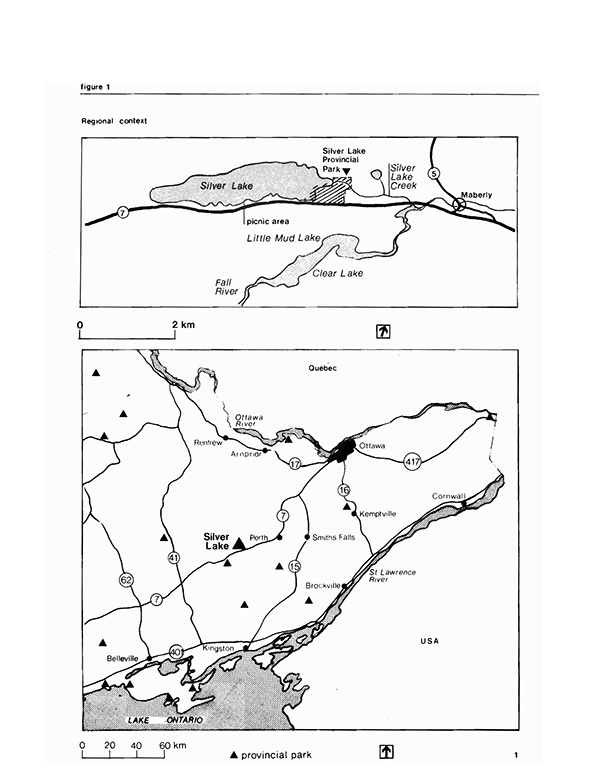
Figure 1 - Regional Context Map.
Enlarge Figure 1 - Regional Context Map.
Introduction
Silver Lake Provincial Park is located on Highway 7 at the eastern tip of Silver Lake in South Sherbrooke Township, Lanark County. It is a relatively small park of 43 ha and is 28 km west of Perth, the largest nearby town. At a one and one half to two hour drive from Belleville, Brockville, and Ottawa, it serves a population of nearly one million Ontario residents. Figure l shows Silver Lake Provincial Park’s location and relation to other provincial parks.
The landscape of the park is characteristic of the southern Precambrian Shield: rocky outcrops and swampy lowlands with a range of biotic communities. There are no life science, earth science or cultural features of major significance. There is a great blue heronry just east of the park and often these birds feed in the park along the creek or in the marsh.
The main attraction is the park’s natural sandy beach. The large beach areas combined with the pleasant natural surroundings result in a high level of use at the park.
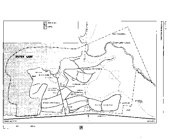
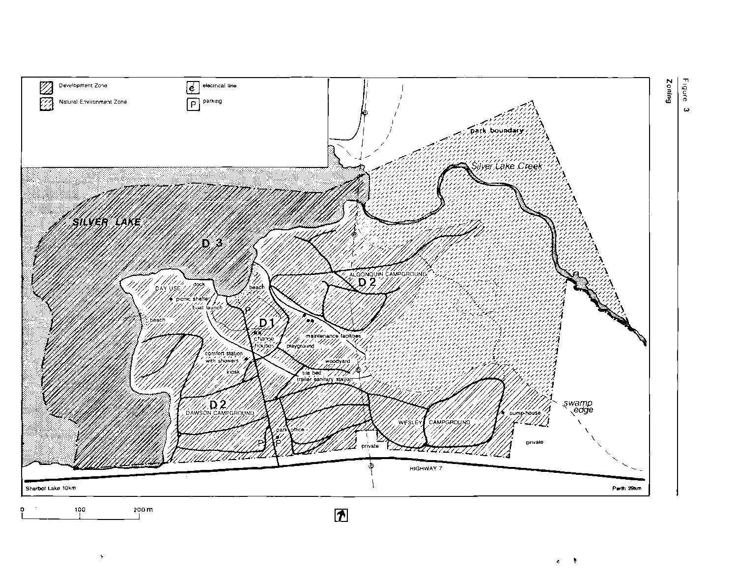
In the early 1960's there were 196 campsites in the park. Over the years many sites have become eroded or unstable and in need of improvements due to their initial high density development, their location and subsequent overuse. The number of sites has been gradually decreased to the present 150. There are three campgrounds, one of which includes a number of trailer sites. The park also has a playground, a woodlot, a washroom building with flush toilets and showers, two pair of vault toilets with cold running water, several small maintenance and garbage sheds, a trailer sanitary station, a pair of change houses, a picnic shelter and a large parking area close to the main beach. Figure 2 shows the location of this existing development.
Almost 47% of the park’s campers come from the Ottawa-Carleton region. [8:27] The campground occupancy rate for July and August has averaged between 45 and 67% over the past ten years, with 100% occupancy frequent on weekends. More than 45% of park permits issued are for day use suggesting that the beach is a locally significant recreational resource. [12:8]
The daily operation and maintenance of the park since 1984, has been done through a contract agreement with a private operator. Park management continues to follow Ministry of Natural Resources policies.
Issues
There are two issues: screening between campsites for privacy and campsite deterioration. Both problems are a result of development and use that have occurred in the park. Some action has been taken in the past to resolve these problems, such as closing badly deteriorated sites and stabilizing slopes around campsites.
Consideration was given to further reducing the number of sites but this would mean turning away visitors on busy summer weekends. Instead existing sites will be improved by screening for privacy with plant material, improvement of tent pads and better defined parking areas.
Figure 2 - Existing Development Map.
Enlarge Figure 2 - Existing Development Map.
Park policies
Classification
"Recreation Parks are areas which support a wide variety of outdoor recreation opportunities for large numbers of people in attractive surroundings." [11] Silver Lake Provincial Park is classified as a Recreation Park because of its emphasis on providing quality camping, picnicking and swimming in a natural setting.
Goal
The goal for Silver Lake Provincial Park is to provide a wide range of recreational opportunities within the capabilities of the land base while encouraging the appreciation of the province’s natural heritage and contributing to tourism in the region.
Objectives
To achieve this goal the following objectives have been set for the park. [10:R-i-31]
Protection
- to protect provincially significant elements of the natural and cultural landscape of Ontario
The Silver Lake Creek area is locally significant as habitat for a variety of wildlife species and for its diversity of vegetation. Development here will be limited to a boardwalk, signs and minimal interpretive facilities to support low intensity day use recreational activities.
Recreation
- to provide provincial park day use and facility based camping opportunities in an attractive setting
Silver Lake Provincial Park annually provides the following supply of recreation opportunities. [4:34] (Shown in brackets is % of Carleton Place District supply.)
- swimming: 15 064 (23%)
- picnicking: 21 732 (13%)
- camping: 48 825 (21%)
The three campgrounds and the day use area are located around the highly developed main sand beach and the neighbouring boating facilities. swimming, sunbathing, sailing and waterskiing are favourite activities here.
There is no area for campground expansion. The District Land Use Guidelines indicate adequate camping opportunities in the district. [4:34]
Heritage appreciation
- to provide opportunities for exploration and appreciation of the outdoor natural and cultural heritage of Ontario.
The clear lake water and clean sand beach offer opportunities for visitors to enjoy same of the province’s natural recreation potential. The boardwalk trail through the park’s wetlands promotes an understanding and appreciation of the diversity of biotic communities in the province.
Tourism
- to provide Ontario residents and visitors from outside the province with opportunities to discover and experience the distinctive regions of the province
Day use and camping opportunities in an attractive setting on an extension of the Canadian Shield will continue to attract local visitors and tourists. Points of interest in Lanark County such as stonebuilt towns and the White Lake Fish Culture Station will be promoted to park visitors to encourage them to stay longer in the Lanark County area.
Figure 3 - Zoning.
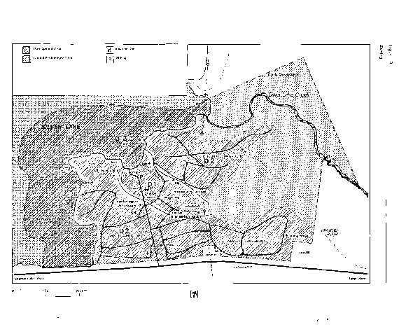
Enlarge Figure 3 - Zoning Map.
Zoning
Two types of zones, development and natural environment, are designated to guide the management of the park. These will be managed in accordance with ministry guidelines for the zone type. [10:R-III-1 to R-IV-7] Figure 3 shows the park zoning.
Development zones
Development zone Dl (3 ha) has the highest development capability. See background information document. [13:23 to 25] Fill and some tile drainage has been placed between the rock ridges and the area now sites the main beach, the large parking area, playground and woodlot/storage area.
Development zone D2 (15 ha) has moderate to high development capability. See background information document. [13:23 to 25] Development can occur in this area with special consideration given to its intensity and to construction techniques. Shallow soils and steep slopes necessitate such considerations. The three campgrounds and the day use area are within this zone.
The primary function of development zones is to accommodate intensive recreational use in areas with the physical capacity to sustain it. They cover about 60% or 18 ha of the park’s land area plus the lake area within the park boundaries. Because the lake area has potential for development such as floating platforms and because motorboating and waterskiing will be allowed, it has been included in the development zone as D3 (13 ha).
The entire development zone (31 ha) will help in achieving the park’s recreation objective.
Natural environment zone
The natural environment zone covers wetlands and the slow moving water of Silver Lake Creek. It covers about 40% or 12 ha of the park’s land area. It has lower development capability but higher interpretive potential than other sections of the park. This area is locally significant because it has habitats attractive to a variety of wildlife species. Having a good diversity of vegetation it is also the best area in the park for observing wildlife, particularly birds. Great blue herons come here to feed, possibly from the heronry just to the east.
Resource management
The park will be managed in accordance with the ministry’s planning and management policies for recreation class parks. [10:R-IV-1 to 9] Same specific actions to be undertaken are outlined below. For more information on resource characteristics and development capability see the background information document. [13:9 to 22]
Land-form
Land-form management will be undertaken in the park to restore severely eroded areas and to maintain optimum beach conditions. Outside the developnent zone this will normally be limited to trail safety and the perpetuation of natural conditions. Campsite rehabilitation will include soil stabilization for erosion control. Other steep areas of the park will be protected from erosion by maintaining vegetation cover and managing recreational uses. These actions may include placement of sand or soil mix, plantings and the construction of small retaining walls. Beach areas will also be monitored for signs of overuse or unstable conditions.
Water
Water quality will be managed to ensure safe swimming areas and drinking water. The quality of drinking water and water at the beaches is routinely sampled and checked according to standard park operating procedures.
The water pipe from the lake will be made operational for use as a back-up system for washroom facilities.
Vegetation
Vegetation management for the park has three objectives: to provide pleasant settings for recreational activities; to provide opportunities for appreciation of native flora and to ensure visitor safety in the park. Natural vegetation may be manipulated to meet these objectives. With these objectives a vegetation management plan will be prepared and will address the following items.
Large mown areas will be maintained only at high use areas such as the day use are, playground, play field and at septic beds. Trees may be removed where they are diseased and pose a hazard and also as part of campsite and picnic area improvements.
Planting will be limited to indigenous native species with the exception of vegetation barriers between campsites where native species may be difficult to establish or less effective than other species. Selective thinning in the campgrounds will aid understory growth and improve overall campsite quality. Spraying with insecticides or fungicides will be initiated to control diseases and insects affecting vegetation only if health, environmental quality, aesthetics, user satisfaction or adjacent properties are threatened. Otherwise plant diseases will be tolerated.
Gypsy moth, Lymantria dispar (Linnaeus), an insect causing defoliation of trees and a nuisance to park users has infested the park. [1] A program to control it in the park has been approved for the 1985 season. [7] The program involves helicopter spraying infested areas with Bacillus thuringiensis (Bt), a biological insecticide. The objectives of the program are to provide foliage protection, to reduce gypsy moth population in campground areas, to prevent stress and tree mortality from defoliation, and to minimize the long distance spread of gypsy moth by recreational vehicles carrying the insect’s eggs, larvae and pupae.
Forest fires will be suppressed in keeping with provincial fire management policies and plans. [3]
Trees will be removed and grounds graded between the playground and woodyard so that the area may be used for active sports such as softball and football. Following a planting plan, planting in the large parking area will provide shade for vehicles and act as transition from the wooded campgrounds to the open beaches. This plan will also give consideration to transplanting trees from the play area to the parking area. These actions and any long term tree planting program that may be developed for the park will be conducted in cooperation with the Regional Landscape Architect and will be addressed in the vegetation management plan for the park.
Wildlife
The objective of wildlife management is to retain fauna diversity and habitat and to enhance wildlife viewing and interpretive opportunities in keeping with the recreational environment of the park. Hunting and trapping are prohibited within the park. Control of problem or nuisance animals identified by the Park Superintendent may be carried out following a wildlife management plan to prepared and approved by the Regional Director.
Fish
The objective of fish management is to provide fishing recreation consistent with a healthy fish community. Sport fishing on Silver Lake will be encouraged for a variety of species. Although the angling quality is not high the lake does offer cold and warm water species, including lake trout, northern pike, bass, perch and splake.
Aesthetics
The management objective is to foster an attractive recreational park envirornnent with characteristic sights and sounds. Implementation of the management plan will consider aesthetic qualities within the park environment. Areas offering scenic views over Silver Lake have been identified and will be protected. In siting buildings, facilities and plantings an attempt will be made to recreate or reinforce the natural landscape.
Client services management
Visitor services
The visitor services goal is to encourage visitors to discover and appreciate the park’s resources and facilities and to encourage participation in recreational and cultural opportunities outside the park. [5] Communications of park staff will inform visitors about the Ontario provincial parks system and will orient them to park facilities and local and regional attractions.
The park’s resources will be interpreted mainly through self-use facilities, particularly the kiosk and the marsh trail. Films may be shown occasionally at the picnic shelter by park staff. Themes will be south shield geology and ecology.
Generally, organized outdoor recreation programs and activities will not provided. Opportunities will be available for informal field and ball sports. The creative playground will be maintained in a safe and attractive condition. Special recreational events or skill training sessions in cooperation with other agencies or clubs will be encouraged.
School groups will be encouraged to use the park’s facilities for outdoor education purposes, especially during fall, winter and spring seasons. Priority will be given to studies promoting discovery and the acquiring of outdoor skills having minimal impact on the park environment.
Park and regional visitor services plans have been prepared giving further direction to visitor service efforts consistent with these guidelines. [5]
Marketing
The existing marketing plan [6] will be updated and revised to include promotion of the park as a base for exploring the surrounding area. Emphasis will be placed on early summer and fall use of the park in recreational driving including promotion of the park to touring agencies.
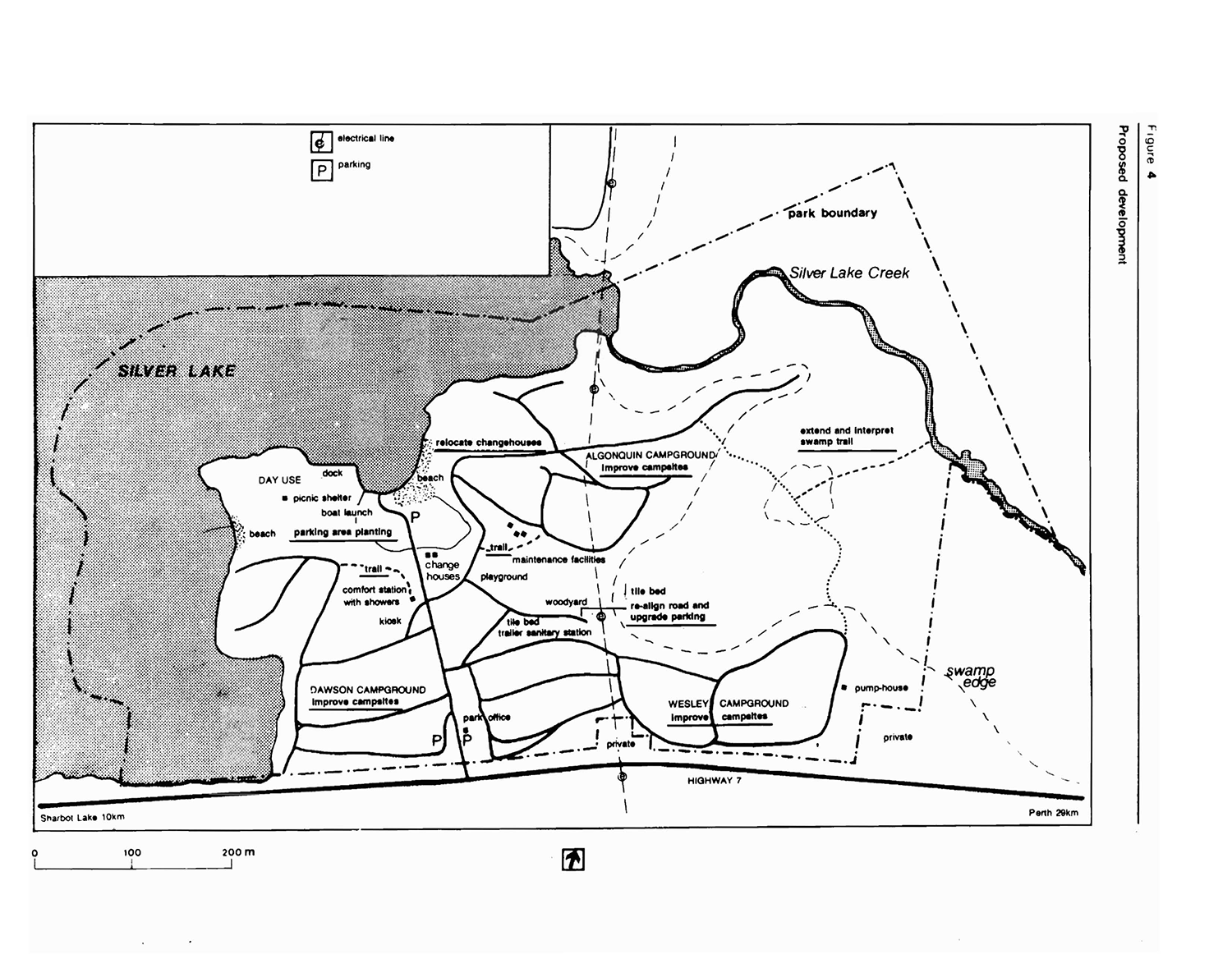
Proposed development
In keeping with the goal to provide a wide range of recreational opportunities and encouraging the appreciation of the province’s natural heritage, development is proposed as outlined below. Development and improvements to Silver Lake Provincial Park will proceed according to Figure 4, these guidelines and appropriate site plans.
Campgrounds
There are now 150 campsites in 3 campgrounds. A number of sites are in need of rehabilitation.
Many of the campsites are to be improved with the planting of ground cover, shrubs and trees to provide a visual barrier for privacy as well as to help define campsites and campsite parking areas. Selective thinning of trees will be done where feasible to provide some morning sun and aid understory growth. Campsites requiring rehabilitation need soil retention through planting and/or retaining structures.
Shoreline facilities
The park’s beach area occasionally reaches its capacity on weekends during July and August. This is controlled by limiting the number of day use vehicles allowed into the park. The smaller western beach attracts people who enjoy more privacy.
The boat launch and dock are not in a very compatible position with the main beach area. However, no major problems have been experienced, so they will remain as they are. If problems develop, relocation of the boating facilities to the western beach will be considered. See the background information document for details. [13:26]
A sign will be posted on the dock advising boaters to avoid the swimming area when approaching the dock or dropping off waterskiers.
The change houses will be relocated closer to the beach to better serve swimmers.
Traffic and parking
The present traffic system works adequately during the peak summer season, though minor improvements will be made to ensure safe and efficient traffic flow.
A site plan will be prepared for the large parking area by the main beach to improve its functional and aesthetic quality. It will propose tree planting to supplement the existing trees. The road leading to the woodyard will be adjusted to provide for a new tile field for the comfort station if the need arises. A parking area for day users will be defined between the new tile field and the woodyard. This additional parking will serve as overflow on busy summer weekends and will be needed after planting is completed at the main parking area. Other smaller parking areas will be upgraded as required.
Trails
All motor vehicles and bicycles are restricted to the park’s road system. Two walking trails leading to the comfort station will be upgraded. The short trail going behind the kiosk will be closed.
The swap trail will be upgraded and self-guiding interpretation of the park’s geological and biological features will be established. The trail will be extended to the creek where the flora and fauna differ fran other areas of the park.
Visitor services facilities
Emphasis at Silver Lake Provincial Park will be on providing basic self-guiding interpretive information and recreational facilities. Upgrading the swamp trail to provide self-guiding interpretation is the first priority. The kiosk will provide information on the provincial parks system and the geological and biological history of Silver Lake. Local and regional attractions in Lanark County such as the White Lake Fish Culture Station will also be promoted at the kiosk.
Figure 4 - Proposed Development Map.
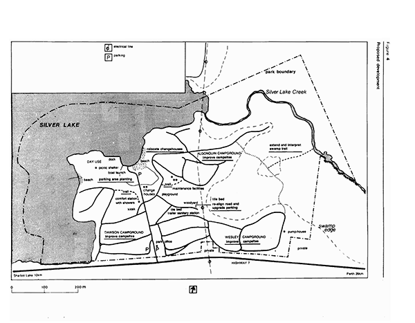
Enlarge Figure 4 - Proposed Development Map.
Implementation strategy
The following projects will be undertaken on approval of the management plan. Campletion wi11 depend on Ministry of Natural Resources' priorities for funding. The management plan will be reviewed as the need arises over its 20 year term.
Phase I
Low cost projects to be undertaken as soon as possible
- upgrade trails to comfort station
- prepare planting plan for main parking area
- post sign on dock indicating proper approach for waterskiers
- rehabilitate campsites through slope stabilization, tent pad improvement, placement of fill
Phase II
Higher cost projects with potential for generating more park use
- improve campsites through opening tree canopy and by shrub and ground cover planting
- implement planting plan at main parking area
- transplant trees in centre of play areas using tree spade
- establish interpretive facilities for swamp trail
- improve small parking areas for camper’s additional vehicles
Phase III
Projects without revenue benefits
- improve circulation and safety on park roads
- relocate change houses
- consider relocation of dock
Public consultation
Comment on the park’s future management was invited during the management planning process. News releases were sent to local radio stations and to newspapers in Kingston, Smiths Falls, Perth and westport inviting review and comment on the 1984 preliminary management plan from park users, local governments and adjacent landowners. A display was set up at the park to solicit comment from park visitors.
There was minimal response to the preliminary plan and no major concerns were raised. Incorporating same minor changes and updating, this approved management plan confirms the park policies set out in the 1984 preliminary management plan. It will guide the management of Silver Lake Provincial Park for the next 20 years.
Bibliography
- Canadian Forestry Service and Ontario Ministry of Natural Resources. The Gypsy Moth. Leaflet, Catalog Number: Fo29-1/5-1983E. Sault Ste. Marie: Great Lakes Forest Research Centre Information Office, 1983.
- Chapman, L. J. and D. F. Putnam. The Physiography of Southern Ontario. Second edition. Toronto: University of Toronto Press, 1966.
- Ontario Ministry of Natural Resources. Aviation and Fire Management Policy # AF.03.01.01. Sault Ste. Marie: Aviation and Fire Management Centre, 1983.
- Ontario Ministry of Natural Resources. Carleton Place District Land Use Guidelines. Carleton Place, 1983.
- Ontario Ministry of Natural Resources. Eastern Region Provincial Parks Visitor Services Plan, draft. Unpaged, unpublished report. Kemptville: Parks Branch, 1984.
- Ontario Ministry of Natural Resources. Marketing Strategy for Silver Lake Provincial Park. Unpublished report. Carleton Place District, 1984.
- Ontario Ministry of Natural Resources. 1985 Gypsy Moth aerial spray proposal for the Eastern Region. Unpublished. Kemptville, 1984.
- Ontario Ministry of Natural Resources. 1978 Provincial Park Camper Survey Summary Statistical Report. Toronto: Parks and Recreational Areas Branch, 1979.
- Ontario Ministry· of Natural Resources. 1978 Provincial Park Day User Survey Summary Statistical Report. Toronto: Parks and Recreational Areas Branch, 1979.
- Ontario Ministry of Natural Resources. Ontario Provincial Parks Planning and Management Policies. Toronto: Parks and Recreational Areas Branch, 1979.
- Ontario Ministry of Natural Resources. Ontario Provincial Parks Policy. Publication Number 5739. Toronto: Park Planning Section, 1978.
- Ontario Ministry of Natural Resources. Ontario Provincial Parks Statistics 1983. Publication Number 5628. Toronto: Parks and Recreational Areas Branch, 1984.
- Ontario Ministry of Natural Resources. Silver Lake Provincial Park Background Information 1984. Unpublished report. Kemptville: Parks Branch, 1984.
- Ontario Ministry of Treasury, Economics and Intergovernmental Affairs. Ontario Population Projections to 2001. Toronto: 1974.
- Tourism and Outdoor Recreation Planning Study Committee. Tourism and Recreational Behaviour of Ontario Residents, Volumes 1 to 8. Toronto: Queen’s Park, 1977.
- United States Department of Agriculture. The Gypsy Moth: Research Toward Integrated Pest Management. Technical Bulletin 1584. Edited by Charles C. Doane and Michael L. McManus. Washington, D. C., 1981.
- Woerns, Norbert. Earth Science Inventory Checklist, Silver Lake Provincial Park. Toronto: Ontario Ministry of Natural Resources, 1977.