Site Readiness Program Guide
Read the full program guidelines for submitting an application to the Site Readiness Program.
Program overview
The Site Readiness Program (the “program”) supports investment attraction and business expansion opportunities in Ontario. The program responds to the new reality of shortened timelines for site selection for companies looking for their first or next location in Ontario. The program provides funding assistance to successful Applicants to help prepare their eligible industrial properties for potential buyers and investment. The program is provided through the Ministry of Economic Development, Job Creation and Trade (MEDJCT) and with support from other Ministries involved in land development in Ontario.
The program provides partial reimbursement to property owners who complete the work plan for an eligible industrial property. The work plan that is funded under the Program is intended to include items most required by companies making site selection decisions for investment and expansion projects.
Upon completion of the work plan, participants of the program qualify for reimbursement of 50% of eligible costs - to a maximum of $25,000 - per site. Eligible costs include costs associated with the application and completion of the work plan.
The program is a discretionary, non-entitlement funding program. Acceptance into the program is based on the merits of the application and available program funding. Even if an application meets all program objective and eligibility criteria, there is no guarantee that the Applicant will be awarded funding under this program. Without limiting the generality of the foregoing, the Applicant acknowledges that if an Applicant submits an application, the Province of Ontario is under no obligation to approve funding.
Please note that the Province of Ontario will not represent or warrant the accuracy or completeness of the information provided by Applicants in the application form and any other information submitted by Applicants or by third parties that may be made available to any agents, prospective purchasers or other parties. Capitalized terms have the meaning set out in the glossary which can be found at the bottom of this Guide.
Minimum eligibility requirements
The mandatory requirements that must be met for a site to be eligible for the program are identified below (the “minimum eligibility requirements”):
Application submission
An application may be submitted for one (1) Site that could consist of multiple lots.
The site must be vacant with no existing buildings or structures.
Site ownership
The program is open to publicly-owned and privately-owned land.
The Applicant must be the registered owner of the site.
If the site is a combination of multiple Lots, the Lots must have the same registered owner on title. Registered owner(s) must be willing to enter into a contract with the Province of Ontario to participate in the program.
Official plan and zoning
The site must be located within an area designated for employment or industrial development uses in an in-effect official plan and zoned to permit a wide range of industrial uses.
Applicant eligibility
Applications must be submitted by the registered owner(s) of the site.
Applications must be sponsored/endorsed by either the municipality or regional economic development organization and by the municipal Chief Planning Official or their delegate.
Applicants are limited to submitting five (5) applications for reimbursement per year. Sites that are current participants in the Investment Ready: Certified Site program are not eligible.
Applicants who have been previously accepted to the Investment Ready: Certified Site program but are no longer actively certified in the program (for example: certifications have expired or Applicants have withdrawn from the program), are eligible to apply.
Commitment to make the site available for sale/lease
The Applicant(s) must agree to make the site available for sale/lease for at least one (1) year following the date of completion of the program, unless sold.
Minimum property size
The site must consist of at least five (5) acres or two (2) hectares of vacant, contiguous net developable area.
Existing public road access
The site must have existing frontage and access from a public right-of-way.
Minimum servicing requirements
The site must have a minimum of two (2) of the five (5) services listed below, at the lot line or within 500 meters of the lot line at the time of acceptance into the program. Supporting documents must be provided as confirmation of service location.
Municipal water
A letter from the municipality’s public works department and/or public utilities commission. This letter should confirm services are at the lot line or within 500 meters of the lot line and outline service capacity at the time of acceptance into the program.
Municipal wastewater
A letter from the municipality’s public works department and/or public utilities commission. This letter should confirm services are at the lot line or within 500 meters of the lot line and outline service capacity at the time of acceptance into the program.
Electricity
The Province of Ontario will acquire these letters on behalf of the Applicant.
Natural gas
The Province of Ontario will acquire these letters on behalf of the Applicant.
Telecommunications
A letter from the local telecommunications provider. This letter should indicate that telecommunications services and infrastructure are onsite or within 500 meters of the lot line. This letter should also outline the type and capacity of the service.
The letter must be provided on corporate letterhead and be signed by a staff person within the telecommunication provider’s provisioning department who has the authority to provide such information.
Remaining utility services
Supporting documents required:
- providing the Municipality’s servicing plan and demonstrating that the site is within the municipality’s urban boundary
- public utilities commission modelling
- development or servicing agreements
- a letter of confirmation from utility service providers
Dry industrial sites
Sites zoned specifically for dry industrial uses, which are not serviced by municipal water and/or wastewater, must demonstrate that there is sufficient water capacity to support permitted uses under the respective municipality’s zoning by-law, with a Hydrogeological Study prepared by a qualified professional.
Supporting documents required:
- hydrogeological study and if available
- confirmation/modelling from municipality’s public works department and/or public utilities commission
Major development constraints
The property must not be subject to significant development restrictions that could impact the building lot or the various industrial and other permitted uses of the site(s). Possible restrictions would be restrictions on title, known flood zones and the presence of features of provincial natural or cultural heritage interest, species at risk, deferred use symbols on the site(s) listed in the municipal zoning by-law, easements, road projects or existing rights-of-way.
How the Site Readiness Program works
Step 1: Pre-application consultation
The complimentary pre-application consultation is the required first step in the application process.
Pre-application consultations are used to determine if a proposed site meets the minimum eligibility requirements. Pre-application consultations are also an opportunity to discuss projected timing, the work plan and budget and to strengthen a prospective Applicant’s application. Applications cannot be submitted without completing a pre-application consultation.
A recommendation to apply or applying to the program does not guarantee acceptance into the program or funding.
To arrange a pre-application consultation, Applicants should contact the program staff at
Step 2: Application submission
Following the pre-application consultation, a prospective Applicant will receive a written invitation to submit an application package that consists of a completed application form and supporting documentation through Transfer Payment Ontario (TPON).
The information provided on the application form and supporting documentation will be used by review committees to evaluate the application package in greater detail.
The application package must consist of the items listed in Table 1: Application package below, unless stated otherwise.
Only complete applications will be considered.
Table 1: Application package
Application form
A signed, completed application form through Transfer Payment Ontario.
Signed application sponsorship form from an Economic Development Officer and Chief Planning Official
Completed form signed by the municipality’s Economic Development Officer and Chief Planning Official.
Site Readiness Program Application Sponsorship
Supporting documentation
Aerial photo
An aerial photo of the Site with parcel boundary clearly shown.
Context map
A context map of the Site with parcel boundary clearly shown, including:
- infrastructure elements (e.g., roads and railways, provincial and national parks, place names, municipal and township boundaries, lots and concessions)
- natural elements (e.g., lakes and rivers, falls, rapids and rocks, wooded areas, wetlands)
- surrounding uses within approximately 1-5 km radius
Topographic map
A detailed, accurate graphic representation of features of the Site that appear on the earth's surface, using contour lines at a scale of 1:50,000.
Net developable area map
A map showing the net developable area of the site in accordance with the in-force zoning by-law.
Excerpts of the in-effect municipal official plan and applicable zoning by-law which include the date the official plan and zoning by-law that came into effect.
Property survey that includes all Lots that forms the site.
Parcel register
Parcel register report and the index map from the Ontario Land Registry Office.
Utility servicing support documents
Supporting documents that confirms the site’s utility servicing locations and serviceability as identified in “Minimum Servicing Requirements” section.
Title search opinion/certificate (if applicable, as directed by program administrators)
Title Search or a Certificate of Title prepared by a solicitor for the site. This should include any information for encumbrances, land claims and sub-surface/mineral rights if applicable as well as other legally relevant information such as encumbrances, encroachments and/or easements.
Land and division (for properties located in the business/industrial parks)
A draft approved plan of subdivision that clearly identifies each Lot that forms part of the application.
Step 3: Application evaluation and notice of acceptance
Complete applications will be evaluated based on the program’s criteria for acceptance into the program.
The Site will be assessed based on the information provided about each lot that makes up the site. One approval does not guarantee that all lots will be approved to proceed to complete the program.
Applicants will receive a written notification if the site has been accepted into the program within 45 business days.
Applicants whose site has been accepted will be offered an agreement contract to formalize their participation in the program.
Step 4: Completion of work plan
Once the Applicant has been issued a Notification of Acceptance and formalized their participation into the program, the Applicant may complete the work as outlined in the work plan.
The work plan must be completed within one (1) year of the notification of acceptance.
Step 5: Completion of the program
Program staff will review the completeness of the submitted work as outlined in the work plan.
Once the work plan has been deemed complete by the program staff, the Applicant can submit expenses for reimbursement.
The Applicant can submit invoices to receive reimbursement of eligible costs. Program staff calculates the actual grant payment amount based on approved eligible costs. Applicants are entitled to be reimbursed 50% of the total eligible costs to a maximum of $25,000 per application.
Internal inventory for site selection inquiries
Once the work plan has been fully completed, the Applicant has the option to include the site into the Province of Ontario’s listing of sites used to help attract potential investors.
Eligible costs and reimbursements
A maximum grant of 50% of eligible costs, up to $25,000 per site, will be paid as a reimbursement of eligible costs provided the following conditions have been met:
- applications have been accepted into the Site Readiness Program through the application process
- the activities identified in the work plan has been completed and its completeness confirmed by program staff
- the Applicant has entered into and agreed to the terms of a funding Agreement with the Province of Ontario
- to receive reimbursement, invoices for each eligible cost are required and must be submitted after the completion of the work plan. All invoices must itemize the work completed for the program. Please ask your service provider to include on all invoices, the references to the site (i.e. legal description or municipal address) for which the work is being completed
Definition of eligible costs:
- Eligible costs must be costs incurred by the Applicant.
- Eligible costs can include costs incurred from the pre-application consultation date for the site.
- Eligible costs must be directly related to the project and be in accordance with the terms of the agreement and be actual cash outlays to third parties that are documented through paid invoices and proofs of payment and are not to exceed fair market value.
- In the event of any interpretation issues regarding expenditures and valuations, the decision of the Ministry is final and determinative.
Eligible reports
The list below outlines due diligence and site preparation work that is often requested by site selection advisors and typically required as part of site preparation or certification programs in North America. If due diligence work has already been carried out for the site, it is recommended to provide proof of this as an annex to the application, so that the program team can review it during the assessment.
Eligible costs for completion of the work plan include assessments and documentation prepared by qualified professionals and meet municipal or provincial standards for the following services:
- Arborist Report/Tree Survey
- Archaeological Study (Stage 1,2,3 and/or 4)
- Conservation Authority studies/drawings
- Drainage Plan
- Environmental Impact Study (EIS)
- Environmental Site Assessment Phase I, II (ESA)
- Erosion/ Sediment Control Plan
- Geotechnical Study/ Slope Stability Study
- Grading Plan
- Groundwater Impact Study
- Heritage Impact Assessment
- Hydrogeological Study
- Hydrological Report
- Natural Heritage Impact Study
- Noise Impact Study
- Pedestrian Level Wind Study
- Planning Rationale Report
- Servicing Options Report
- Soil Management Report
- Species At Risk Assessments/Mitigation Report
- Stormwater Management Report
- Topographic Survey Plan
- Tree Preservation Plan
- Transportation Impact Study
- Utility Plan
- Vibration Study
- Other (as approved by program staff)
Additional eligible costs
The following list outlines additional eligible costs that may be incurred as a result of applying to the program or completing the project:
- mapping (e.g. topographic map, environmental context maps)
- aerial photograph or video of site with parcel boundary clearly shown
- parcel register, Title Opinions, and Property Index Map
- plan of survey
- legal fees (including contract and fees associated with updating site description information)
- surveyor’s real property report
- property assessment/valuation reports
Types of ineligible costs
Applicants will not be entitled to reimbursement by the Ministry for any of the following:
- costs incurred prior to the pre-application consultation date
- infrastructure or capital costs related to bringing the site up to eligibility and property standards, site preparation, maintenance and property taxes
- capital costs: infrastructure development, capital expenditures to acquire or enhance assets, software licenses, electronics (computers, fax, machines, digital cameras, etc.), and demonstration aids. Capital costs include the direct costs of acquisition, construction, expansion, modification, conversion, transportation, installation and insurance (during construction) of fixed assets, as well as the cost of licensing and franchising fees
- costs paid to an Ontario Ministry, Ontario Agency or Crown Corporation
- travel costs and accommodations incurred by the Applicant, agent or third-party consultants as a result of the preparation of the application or completion of activities related to the work plan
- ongoing operational expenses including labour costs, office and overhead expenses e.g. salaries, wages, including those of staff working on the application
- costs not incurred in Ontario, except when the only supplier(s) of services are outside of Ontario with proof and/or prior written approval
- entertainment expenses, meals or alcoholic beverages
- in-kind contributions
- costs, including taxes, for which the Applicant has received, will receive or is eligible to receive a rebate, credit or refund
- consultant fees are ineligible where there is an indication of an employer-employee relationship to be determined by the Ministry in its sole discretion
- project management consultant fees
- miscellaneous: activities for which one or more partners expect to receive compensation in the form of a commission, finder's fee
- fees associated with municipal planning applications unless required and pre-approved by the program
- activities related to remediation of the site
Stacking of funds
Stacking of Provincial support will be considered on a case-by-case basis. Stacking of funding from complementary programs may be acceptable to the Ministry in its sole discretion for eligible costs that:
- are ineligible costs in such complementary programs; and
- will not be reimbursed by the Province of Ontario under such programs.
Glossary
The Site Readiness Program Guide contain a number of “standard” words and phrases throughout the document. The following is a list of some of those terms together with an explanation of their meaning, which will help you interpret the application form and the Site Readiness Program Guide.
Agreement
The agreement entered into between the Province of Ontario and the Applicant formalizing the Applicant’s participation in the Site Readiness Program including all of the schedules and any amending and license agreements entered into.
Airports
All Ontario airports, including designated lands for future airports, with Noise Exposure Forecast (NEF)/Noise Exposure Projection (NEP) mapping. For the purposes of this program the term airport refers to nationally-significant, regional and local airports that are governed by the Federal government's National Airports Policy (NAP).
Nationally-significant airports are defined as airports that link the country from coast to coast and internationally. Regional/Local airports are airports:
- with scheduled passenger traffic that is less than 200,000 a year for three consecutive years
- not classified as Arctic or remote airports
- where there is currently some form of ongoing federal financial involvement relating to the ownership or operation of the airport
Agent
Any professional that the Applicant appoints to act on its/his/her behalf in relation to this application.
Applicant
An individual(s) or corporation who has legal ownership of a site (registered owner) and who has made an application to the Province of Ontario’s Site Readiness Program.
Application
The completion and submission to the Ministry of a Site Readiness Program application form together with all requisite work plan, technical studies and any supporting documents deemed necessary by the Ministry.
Application sponsor
A municipal economic development officer (EDO) or a planning official who has been delegated authority to assist the Applicant with obtaining the necessary Site-specific information to complete a Site Readiness Program application, review the application for accuracy of municipal information and support the Applicant’s participation in the program.
Archaeological assessment
Identifies and evaluates in stages, the presence of archaeological resources and assesses the degree to which a development proposal may disturb or alter an archaeological landscape. These resources may include physical remains and contextual settings of any structure, event, place, feature or object which because of the passing of time, is on or below the surface of the land or water.
Archaeological resources
Includes artifacts, archaeological sites, marine archaeological sites, as defined under the Ontario Heritage Act. The identification and evaluation of such resources are based upon archaeological fieldwork undertaken in accordance with the Ontario Heritage Act.
Areas of natural and scientific interest (ANSI)
Areas of land and water containing natural landscapes or features that have been identified as having life science or earth science values related to protection, scientific study or education.
Built heritage resource
A building, structure, monument, installation or any manufactured remnant that contributes to a property’s cultural heritage value or interest as identified by a community, including an Indigenous community. Built heritage resources are generally located on property that has been designated under Parts IV or V of the Ontario Heritage Act, or included on local, provincial and/or federal registers.
Business/industrial park
For the purposes of this program, means an area of a municipality specially designated and zoned to accommodate business offices, warehouses and industrial uses.
Certificate of Consent
A certificate issued by the Deputy-Secretary Treasurers of the Committee of Adjustment stating that the city has approved a Consent for Severance. The certificate includes details such as the date of the committee’s decision, the nature of the application and a legal description of the lands that were the subject of the consent. The certificate is conclusive evidence that any conditions of approval have been satisfied and that all provisions of the Planning Act relating to the granting of the Consent have been complied with.
Certificate of Title
A government-issued document that identifies the owner or owners of personal or real property. A Certificate of Title provides documentary evidence of the right of ownership. When issued for real property (such as land or a house) by a title insurance company, the certificate of title is a statement of opinion on the status of the title, based on a thorough examination of specified public records.
Certified Site
A site that has satisfied the requirements to be certified under the Investment Ready: Certified Site Program and received the designation from the Province of Ontario.
Class 1 industry
Small scale, self-contained plant, no outside storage, low probability of fugitive emissions and daytime operations only.
Class 2 industry
Medium scale processing and manufacturing with outdoor storage, periodic output of emissions, shift operations and daytime truck traffic.
Class 3 industry
Processing and manufacturing with frequent and intense off-site impacts and a high probability of fugitive emissions.
Contaminated site assessment
A document that identifies and evaluates the degree of air, water and soil contamination in relation to a property or within a specific area. The document also outlines and recommends methods and measures of remediation to secure public health and safety.
Committee of Adjustment
The Planning Act grants authority to committees appointed by Municipal Councils to approve a number of minor applications. Called Committees of Adjustment, these bodies are empowered to make decisions on minor variances from the zoning by-law. Permission to alter or change a lawful non-conforming use of land. Consent (consent means “approval”) to sever land (divide a parcel of land into more than one lot). Consent to register a mortgage over part of a property. Consent to register a lease over part of a lot for more than 21 years. Validation of land title where an error exists in the description of land.
Complete application
An application will be deemed complete if it is accompanied by the required information identified in this Site Readiness Program Guide and identified through pre-application consultation discussions.
Consent for severance
A municipality must grant consent for the following types of land transactions: divide land (sever) into new lots, and/or add land to an abutting lot (lot additions, lot adjustments, lot extensions, corrections to deeds or property descriptions), and/or establish easements or rights-of-way, and/or lease land or register a mortgage in excess of 21 years.
Municipal council can delegate the approval authority for the creation of new lots to the Committee of Adjustment. Approval authority for all other types of consents has been delegated to the Deputy-Secretary Treasurers of the Committee.
Cultural heritage landscape
A defined geographical area that may have been modified by human activity and is identified as having cultural heritage value or interest by a community, including an Indigenous community. The area may involve features such as structures, spaces, archaeological sites or natural elements that are valued together for their interrelationship, meaning or association. Examples may include, but are not limited to, heritage conservation districts designated under the Ontario Heritage Act; villages, parks, gardens, battlefields, main streets and neighbourhoods, cemeteries, trailways, viewsheds, natural areas and industrial complexes of heritage significance; and areas recognized by federal or international designation authorities (e.g. a National Historic Site or District designation, or a UNESCO World Heritage Site).
Project completion date
The date on which the program staff has deemed the Applicant’s work plan as complete.
Date of pre-application consultation
The date on which the Applicant completes a formal consultation with the program staff regarding the eligibility of the proposed Site.
Deep water port
Any fixed or floating man-made structure other than a vessel, or any group of such structures, usually made up for the usage of very large and heavily loaded ships which may require the water to be 30 feet deep or more. Deep water ports are also defined to be any port which has the capability to accommodate a fully laden Panamax ship, which is determined principally by the dimensions of the Panama Canal’s lock chambers.
Delegated approval authority
The decision-making authority passed down to an alternate, in accordance with Provincial/program statutes.
Deposits of mineral aggregate resources
An area of identified mineral aggregate resources, as delineated in Aggregate Resource Inventory Papers or comprehensive studies prepared using evaluation procedures established by the Province of Ontario for surficial and bedrock resources, as amended from time to time, that has a sufficient quantity and quality to warrant present or future extraction.
Designated and available
For the purposes of this program, lands designated in a municipal official plan for employment, business offices, warehouses, industrial development but which have not yet been developed.
Development
For the purposes of this program, means the construction of buildings and structures requiring approval under the Planning Act.
Dry industrial
Those uses in which only the disposal of the domestic waste of employees is permitted and treated. No industrial liquid wastes, wash or cooling water or process wastes are permitted.
Employment area
Areas designated in an official plan for clusters of business and economic activities including, but not limited to, manufacturing, warehousing, offices, and associated retail and ancillary facilities.
Endangered species
A species that is listed or categorized as an “Endangered Species” on the Ministry of the Environment, Conservation and Parks official Species at Risk list, as updated and amended from time to time.
Environmental impact study
Identifies and evaluates the possible impact a proposed development may have on the social and natural environment and provide measures to alleviate any negative impacts.
Environmental assessment
A decision-making process used to promote good environmental planning by assessing the potential effects of certain activities on the natural and human environment. In Ontario, this process is defined and finds its authority in the Environmental Assessment Act (EAA) and its associated regulations. The EAA applies to undertakings (enterprises, activities, proposals, plans or programs) by provincial ministries, municipalities and prescribed public bodies such as conservation authorities.
Employment area
Areas designated in a municipal official plan for a cluster of businesses and economic activities including, but not limited to, manufacturing, warehousing, offices, and associated retail and ancillary facilities.
Environmental site assessment
An assessment of the environmental integrity of a site and may be required in order for a Record of Site Condition to be filed with the Ministry of the Environment, Conservation and Parks.
Erosion hazard
The loss of land, due to human or natural processes, that poses a threat to life and property. The erosion hazard limit is determined using considerations that include the 100 year erosion rate (the average annual rate of recession extended over a one hundred year time span), an allowance for slope stability, and an erosion/erosion access allowance.
Fish habitat
As defined in the Fisheries Act, Fish habitat means water frequented by fish and any other areas on which fish depend directly or indirectly to carry out their life processes, including spawning grounds and nursery, rearing, food supply and migration areas.
Flood plain
For river, stream and small inland lake systems, means the area, usually low lands adjoining a watercourse, which has been or may be subject to flooding hazards.
Habitat of endangered species and threatened species
As defined in the Endangered Species Act, 2007, species listed on the Species at Risk in Ontario List as an endangered or threatened species for which a regulation made under clause 55(1)(a) of the act is in force, the area prescribed by that and Forestry regulation as the habitat of the species.
Any other species listed on the Species at Risk in Ontario List as an endangered or threatened species, an area on which the species depends, directly or indirectly, to carry on its life processes, including life processes such as reproduction, rearing, hibernation, migration or feeding, as approved by the Ministry of the Environment, Conservation and Parks.
Any places in the areas described in clause 55(1)(a) or (55(1)(B) of the Endangered Species Act, 2007, whichever is applicable, that are used by members of the species as dens, nests, hibernacula or other residences.
Hazardous forest types for wildland fire
Forest types assessed as being associated with the risk of high to extreme wildland fire using risk assessment tools established by the Ontario Ministry of Natural Resources, as amended from time to time.
Hazardous sites
Property or lands that could be unsafe for development or alteration due to naturally occurring hazard. These hazards may include unstable soils or unstable bedrock.
Heritage impact statement (conservation strategy)
A document that provides relevant information on the nature and significance of a heritage property. It outlines the policy framework in which such properties can be conserved and identifies practical options to inform decisions and directions for the development of a conservation plan for the heritage resource.
Incomplete application
An application for this program that does not comply with the information and material submission requirements set out in the application form and Site Readiness Program Guide.
Intermodal transit hub/facility
Stations or centres where different transit modes come together and allow for easy transfers from one mode to another. They can also facilitate transfers at different scales: local, regional and intercity.
Intermodal facilities enable the efficient and convenient transfer of goods between different modes of transport and include specialized equipment that moves commodities from rail to truck and vice-versa. The CN intermodal facility in Brampton and the CP intermodal facility in Vaughan are the largest CN and CP facilities in all of North America.
Note: Multi-modal shipment transfers are not limited to intermodal facilities. Rail spurs and other facilities allow carriers to transfer goods between rail and truck.
Legal description
The written words within a document that defines a parcel of land either by metes and bounds or by reference to a survey plan or registered plan.
Lot
A recognized subdivision of property with a written legal description that addresses permissions or constraints upon its development.
Metes and bounds
That part of a deed or transfer of land in which the boundaries of the property are described only in words without a plan or map. The description will start at a defined point on the ground (e.g., “the North West corner of Lot 1, Concession 1”) and continue around the parcel giving directions and distances or other identifiers and finishing up at the same point as the start.
The metes normally refer to the direction and distance of a boundary segment, such as “Thence N35°44’E, 245 meters to a point”. The bounds would normally refer to a natural feature, such as “Thence along the centre line of Jolly Creek”. Written descriptions are rarely used in current documents, in favour of a graphical representation of the boundary with reference to a plan or a map.
Mineral aggregate operation
Lands under license or permit, other than for wayside pits and quarries, issued in accordance with the Aggregate Resources Act.
For lands not designated under the Aggregate Resources Act, established pits and quarries that are not in contravention of municipal zoning by-laws and including adjacent land under agreement with or owned by the operator, to permit continuation of the operation.
Associated facilities used in extraction, transport, beneficiation, processing or recycling of mineral aggregate resources and derived products such as asphalt and concrete, or the production of secondary related products.
Mineral aggregate resources
Gravel, sand, clay, earth, shale, stone, limestone, dolostone, sandstone, marble, granite, rock or other material prescribed under the Aggregate Resources Act suitable for construction, industrial, manufacturing and maintenance purposes but does not include metallic ores, asbestos, graphite, kyanite, mica, nepheline syenite, salt, talc, wollastonite, mine tailings or other material prescribed under the Mining Act.
Minor variance
Small changes or exceptions to existing land use or development restrictions contained in the zoning by-law are called minor variances. Variances are obtained by making an application to the Committee of Adjustment. Larger changes to the zoning by-law require a zoning by-law amendment. Advice as to whether the proposal may be considered minor, and thus dealt with by the Committee of Adjustment, is provided by planning staff.
Multimodal transportation system
A transportation system which may include several forms of transportation such as automobiles, walking, trucks, cycling, buses, rapid transit, rail (such as commuter and freight), air and marine.
Municipal sewage services
A sewage works within the meaning of section 1 of the Ontario Water Resources Act that is owned or operated by a municipality.
Municipal water services
A municipal drinking-water system within the meaning of section 2 of the Safe Drinking Water Act, 2002.
Natural heritage features and areas
Features and areas, including significant wetlands, significant coastal wetlands, other coastal wetlands in ecoregions 5E, 6E and 7E, fish habitat, significant woodlands and significant valleylands in ecoregions 6E and 7E (excluding islands in Lake Huron and the St. Marys River), habitat of endangered species and threatened species, significant wildlife habitat, and significant Areas of Natural and Scientific Interest (ANSI), which are important for their environmental and social values as a legacy of the natural landscapes of an area.
Natural heritage impact study
A study that identifies natural features and areas including, wetlands, woodlands, valley lands and significant wildlife areas, highlighting a proposed development’s potential impact on the natural heritage system. The study will also provide ways to mitigate negative impacts on and/or improve the natural heritage system.
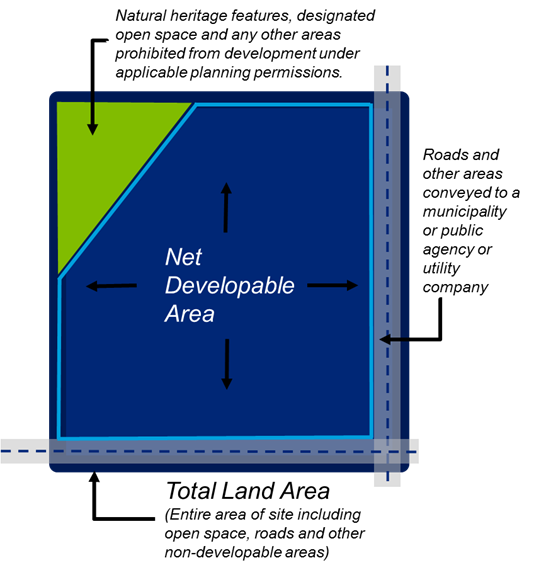
Net developable area
Net developable area refers to the total area of land available for new development, not necessarily the total area of a property itself. It does not include lands needed for open space, wetlands, floodplain, significant woodlands drainage land, regional roads and land used for other public facilities such as hydro corridors, railway right of ways provincial highways etc.
Net developable area includes local access roads, parking areas, footpaths and local open space such as children’s play areas and amenity space.
Notification of acceptance
A letter issued to the Applicants formally stating acceptance of the site into the program.
Official plan
The Planning Act requires each municipality in Ontario to have an official plan. The official plan is a legal document approved by municipal Council/planning board that describes policies and objectives for future land uses. The official plan is prepared in consultation with municipal residents and reflects a community vision for future change and development. The official plan is a blueprint for how a municipality will grow over the next 30 years. It describes the location for new housing, industry, parks, office and retail areas, community services and other land uses. The pfficial plan also establishes policies for the built environment, for improvements to the municipality’s hard services (such as transit, roads, sewers, etc.) and for the protection of the municipality’s natural environment.
Official plan amendment
A site-specific amendment to alter or develop your property in a way that does not conform with the official plan. An official plan amendment must be approved by the municipal council, other local authority exercising any power with respect to municipal affairs or the Ontario Municipal Board.
Oil, gas and salt hazards
Any feature of a well or work as defined under the Oil, Gas and Salt Resources Act, or any related disturbance of the ground that has not been rehabilitated.
Ontario Land Surveyor
An Ontario Land Surveyor (OLS) is a professional member of the Association of Ontario Land Surveyors (AOLS). They are required to maintain the necessary theoretical, practical and ethical standards set by legislation and the profession. More information about the Association of Ontario Land Surveyors. Information about the Surveyors Act.
Ontario Land Tribunal
One of the functions of the Ontario Land Tribunal is to hear appeals from planning decisions of municipal Council and the Committee of Adjustment. It is an independent and impartial adjudicative tribunal. It is made up of a Chair, Vice-Chairs and Members. The Ontario Government appoints all board members who have diverse backgrounds and come from different parts of the province. For more information, see the Ontario Land Tribunal.
Parcel
A unit of land that is registered in the Land Registry Office and identified as such for taxation purposes.
Petroleum resources
Oil, gas, and salt (extracted by solution mining method) and formation water resources which have been identified through exploration and verified by preliminary drilling or other forms of investigation. This may include sites of former operations where resources are still present or former sites that may be converted to underground storage for natural gas or other hydrocarbons.
Plan of subdivision
The Planning Act grants the municipality the authority to regulate the division of land through the registration of Plans of Subdivision. This authority is used to provide for the orderly servicing and development of large parcels of land in accordance with appropriate municipal regulations and standards. Plans of subdivision will typically include information on new municipal infrastructure (i.e., water and sewer servicing and new roads), lot and block patterns and any park and/or school sites. Plans of subdivision are also typically used to create public rights-of-way for municipal services.
Plan of survey
A legal plan of lands outlining the location and dimension of its boundaries and associated encumbrances, prepared by an Ontario Land Surveyor.
A survey plan is a graphic representation showing the true (accurate and precise) location of legal boundaries. It is created from actual field measurements and can be used to accurately locate boundaries on the ground.
Planning Act
The Province of Ontario sets out rules and regulations in the Planning Act which describe how planning processes should be dealt with, how land uses may be controlled and by whom. The Planning Act gives municipalities the power to create official plans and zoning by-laws which in turn provide direction to the various officials, staff members and other authorities involved in the planning and development decision making process.
Pre-application consultation
A formal consultation process which is held before the submission of an application; typically in the form of a meeting arranged with the program staff. This meeting is intended to determine site eligibility, identify issues of concern, guides the content of the application submission (reports, studies, drawings, etc.) and identifies the need for any further applications or approvals.
Property identification number
Each property or parcel of land in Ontario is assigned a unique 9-digit number (e.g., 49876-0123)
Protected heritage property
Property designated under Parts IV, V or VI of the Ontario Heritage Act; property subject to a heritage conservation easement under Parts II or IV of the Ontario Heritage Act; property identified by the Province of Ontario and prescribed public bodies as provincial heritage property under the Standards and Guidelines for Conservation of Provincial Heritage Properties; property protected under federal legislation, and UNESCO World Heritage Sites.
Provincial plan
A provincial plan within the meaning of section 1 of the Planning Act.
Rail facilities
Rail corridors, rail sidings, train stations, inter-modal facilities, rail yards and associated uses, including designated lands for future rail facilities.
Record of site condition
A Record of site condition summarizes the environmental condition of a property, based on the completion of environmental site assessments.
Each record of site condition:
- is based on the results of one or more environmental site assessments
- is conducted by a qualified person
- may involve the completion of a risk assessment and the development of property specific standards
- a qualified person must certify that the property meets the applicable site condition standard or a standard specified in a risk assessment for the intended use
- is filed to the Environmental Registry once regulatory requirements are met
Reference plan
A plan deposited under Section 150 of the Land Titles Act or Sections 80 or 81 of the Registry Act. It shows the boundaries of the parcel of land, the location of easements and can be used to describe the pieces of land forming part of a severance application (shown as parts on the reference plan). The reference plan is a convenient tool used to describe specific lands, it does not create any easements or severances. Once deposited in the land registry office it is given a numerical reference number generally 66R-. Prepared by an Ontario Land Surveyor, it must meet the requirements of the Registry Act.
Registered owner
The legal owner of the site.
Rezoning
If you wish to use, alter or develop your property in a way that does not conform with the zoning by-law, you must apply for a site-specific amendment to the By-law. You can do this through either a zoning by-law amendment application (commonly called a rezoning) or a minor variance application. Rezonings are used for major revisions to the by-law such as land use changes or significant increases in permitted building heights and development densities. minor variances are used for issues such as small changes to building setback or parking requirements.
Right-of-way permit
A permit required if a landowner intends to undertake any work or occupation within the public right-of-way. Permit must be obtained from the municipal Transportation Services Division or the Ontario Ministry of Transportation.
Road network
Network of roads comprising of Provincial highways, parkways, major arterial roads, minor arterial roads, collector roads and local roads.
Sensitive land uses
A building, amenity area, or outdoor space where routine or normal activities occurring at reasonably expected times would experience one or more adverse effect(s) from contaminant discharges generated by a nearby major facility. The sensitive land use may be a part of the natural or built environment. Depending on the particular facility involved, a sensitive land use and associated activities may include one or a combination of:
- residences or facilities where people sleep (e.g. single and multi-unit dwellings, long term care facilities, hospitals, trailer parks, campgrounds, etc.). These uses are considered to be sensitive 24 hours a day
- a permanent structure for non-facility related use, particularly of an institutional nature (e.g. schools, churches, community centres, day care centres)
- certain outdoor recreational uses deemed by a municipality or other level of government to be sensitive (e.g. trailer park, picnic area, etc.)
- certain agricultural operations (e.g. cattle raising, mink farming, cash crops and orchards)
- bird/wildlife habitats or sanctuaries. (MECP Guidelines, Procedure D-1-3, amended)
Site
The land that is under consideration for acceptance into the Site Readiness program. A site may be an assemblage of multiple Lots.
Species at risk
Species at risk means an extirpated, endangered or threatened species or a species of special concern.
Wayside pits and quarries
A temporary pit or quarry opened and used by or for a public authority solely for the purpose of a particular project or contract of road construction and not located on the road right-of-way.
Wetlands
Lands that are seasonally or permanently covered by shallow water, as well as lands where the water table is close to or at the surface. In either case the presence of abundant water has caused the formation of hydric soils and has favoured the dominance of either hydrophytic plants or water tolerant plants. The four major types of wetlands are swamps, marshes, bogs and fens.
Periodically soaked or wetlands being used for agricultural purposes which no longer exhibit wetland characteristics are not considered to be wetlands for the purposes of this definition.
Work plan
Section E in the Site Readiness application form that outline a detailed description of the project, including which eligible report(s) the Applicant plans to undertake, and the costs associated with each eligible report selected.