Sleeping Giant Provincial Park Management Plan
This document provides policy direction for the protection, development and management of Sleeping Giant Provincial Park and its resources.
©2007, Queen’s Printer for Ontario
Additional copies of this publication are available from the Ministry of Natural Resources at the following location:
Sleeping Giant Provincial Park
c/o Ontario Parks
Northwest Zone
Suite 221d 435 James St. S.
Thunder Bay, Ontario
P7E 6S8
807-475-1321
51883
0.5k P.R. 01 03 07
ISBN – 978-1-4249-3309-9
Approval statement
I am pleased to approve the Sleeping Giant Provincial Park Management Plan as the official policy for the management and development of this park. The plan reflects the intent of the Ministry of Natural Resources and Ontario Parks to protect the natural and cultural features of Sleeping Giant Provincial Park and to maintain and develop high quality opportunities for outdoor recreation and heritage appreciation for the residents of Ontario and visitors to the Province.
The plan outlines a prioritized implementation strategy for the plan’s elements and summarizes the consultation that occurred as part of the planning process.
There is a final opportunity to review the approved management plan for a period of forty-five (45) days after its formal release. This allows interested participants in the planning program a final opportunity to determine if their concerns have been considered.
The plan for Sleeping Giant Provincial Park will be used to guide the management of the park. It will be reviewed to address changing issues or conditions as necessary. The Crown Land Use Policy Atlas (CLUPA) will be amended to reflect the policy direction in this management plan.
I wish to extend my sincere thanks to all those who participated in the consultation process.
Yours truly,
Signed by:
Adair Ireland-Smith
Managing Director
Ontario Parks
Date: January 24, 2007
Statement of Environmental Values and the Environmental Bill of Rights
In accordance with the provisions of the Environmental Bill of Rights, the Ministry of Natural Resources prepared a Statement of Environmental Values. It describes how the purposes of the Environmental Bill of Rights are to be considered whenever decisions are made which might significantly affect the environment. This includes decisions made as a result of the park management planning process.
The primary purpose of the Environmental Bill of Rights is "to protect conserve and, wherever reasonable, restore the integrity of the environment." From the Ministry’s perspective, that broad statement of purpose translates into four objectives in its Statement of Environmental Values:
- To ensure the long-term health of ecosystems by protecting and conserving our valuable soil, aquatic resources, forest and wildlife resources as well as their biological foundations
- To ensure the continuing availability of natural resources for the long-term benefit of the people of Ontario
- To protect natural heritage and biological features of provincial significance; and
- To protect human life, the resource base and the physical property from the threats of forest fires, floods and erosion.
The Ministry’s Statement of Environmental Values has been considered in the development of this preliminary park management plan for Sleeping Giant Provincial Park.
1.0 Introduction
Sleeping Giant Provincial Park is classified as a natural environment park and is 24,751.4 hectares in size. It was established as Sibley Provincial Park in 1944, regulated in 1950 (O. Reg. 4/50) and renamed Sleeping Giant Provincial Park in 1988. The park area includes the previously regulated area of 24,400 hectares, plus an additional 351.4 hectares associated with an increase in the Lake Superior natural environment zone. The park includes 2,751.4 hectares of the bed of Lake Superior, since its boundaries extend out 400 metres from the shoreline, except:
- in the vicinity of Thunder Cape
- the section of shoreline associated with the community of Silver Islet (Perry Bay to Fork Bay) and
- the area around Middlebrun Island.
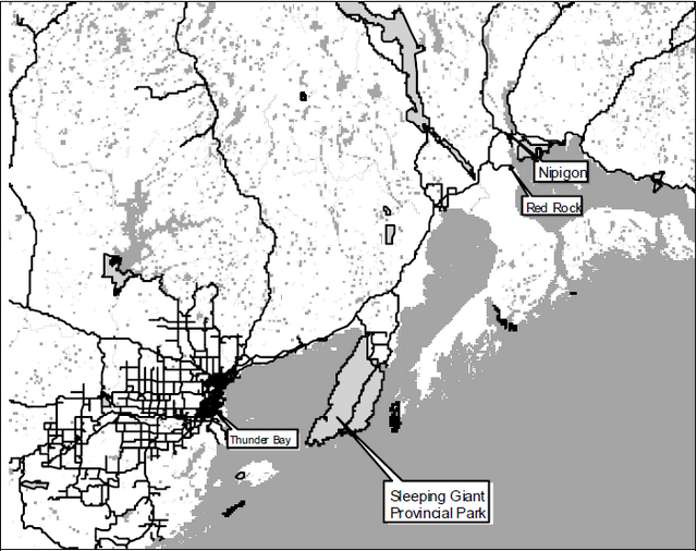
Sleeping Giant is located approximately 40 kilometres east of the city of Thunder Bay (population 109,016 in 2001).
The community of Pass Lake abuts the northern park boundary. Silver Islet, a mostly seasonal community on Lake Superior, is a park neighbour to the southeast. Nearby communities to the east on the Trans-Canada Highway (11/17), include Dorion, Red Rock and Nipigon. The Fort William First Nation borders the city of Thunder Bay to the south.
Sleeping Giant Provincial Park occupies most of the Sibley Peninsula. The park’s eastern lowlands rise gently from Lake Superior, while the western shore is dominated by rugged topography that includes sheer cliffs, deep valleys, and the distinctive mesa–cuestas that form the Sleeping Giant. This varied terrain and the effect of Lake Superior on the park’s microclimates provide a variety of habitats for a great diversity of plants including rare orchids and arctic-alpine disjuncts. The park is home to wolf (Canis lupus), lynx (Lynx canadensis), and bear (Ursus americanus), as well as moose (Alces alces), and white-tailed deer (Odocoileus virginianus). More than 200 species of birds have been recorded at Sleeping Giant, including bald eagle, and peregrine falcon, both of which are species at risk in Ontario.
Visitors access the park via the Trans-Canada Highway (#11/17), and Highway 587. Sleeping Giant Provincial Park is considered a destination park because it attracts visitors seeking outstanding hiking, viewing and nature interpretation opportunities. The park also offers visitors opportunities for cross-country skiing, as well as car and interior camping, roofed accommodations, picnicking, kayaking, boating and swimming. Access to the park may also be gained from Lake Superior by boaters and kayakers.
Sleeping Giant is part of the Great Lakes Heritage Coast. The park is adjacent to Parks Canada’s Lake Superior National Marine Conservation Area (NMCA).
Most visitors to Sleeping Giant are from Thunder Bay and area (50%). The second largest group of visitors is from the American Midwest (25%), specifically Minnesota Wisconsin and Michigan, (OMNR, 1996a,b; CAMIS, 2001). This is in contrast to the origins of park users on a province-wide basis where the majority of park visitors originate in the eastern and central parts of the province and only about 9% of visitors come from the United States.
Sleeping Giant Provincial Park is within the boundaries of lands covered under the Robinson-Superior 1850 Treaty. The Fort William First Nation (Reserve #52) is located adjacent to the City of Thunder Bay. Sleeping Giant Provincial Park is part of the traditional use area of this First Nation. There are no land claims regarding Sleeping Giant Provincial Park at this time.
Fort William First Nation is located within the boundary described by the Treaty #3. Sleeping Giant Provincial Park is part of the traditional use area of this Aboriginal community. Sleeping Giant Provincial Park overlaps traditional lands and waters of this Aboriginal community. Aboriginal communities use the area for hunting, trapping, fishing, and other gathering and travel. These uses may continue, subject to public safety and conservation.
In recognition of the Aboriginal archaeological features located within the park, Ontario Parks will have special regard for local First Nations' interests. Respect and protection of archaeological and cultural features are integral to this park management plan. The Fort William First Nation will be consulted on topics of concern during the implementation of this plan.
Figure 1: Regional Context
This park management plan has been prepared consistent with direction contained in Our Sustainable Future, Ministry of Natural Resources Strategic Directions (2005). The Ministry’s vision is "sustainable development"; and the Ministry’s mission is "ecological sustainability". The Ontario Parks program contributes mainly to the goal of: "Healthy Natural Environment for Ontarians", but contributes to other strategic elements as well. The mandate of the Ministry for Ontario Parks is to deliver Ontario’s parks and protected areas program, which includes: the protection and management of provincially significant natural, cultural, and recreational environments; provincial parks operations; provision of tourism opportunities, natural heritage education; planning and management of parks and protected areas; policy leadership on conservation reserves; monitoring, auditing, and public reporting on Ontario’s parks and protected areas.
This document has also been prepared consistent with direction contained in Protecting What Sustains Us: Ontario’s Biodiversity Strategy (2005). Ontario Parks supports both the first goal "Protect the genetic, species and ecosystem diversity of Ontario", and the second goal: "Use and develop the biological assets of Ontario sustainably, and capture benefits from such use for Ontarians".
The most recent management plan for Sleeping Giant Provincial Park was approved in 1988. It describes Sleeping Giant’s role within the provincial park system, and identifies a series of policies intended to maintain or improve these contributions. That document provided some of the background information for the present planning process. The park management plan
2.0 Park classification
All provincial parks in Ontario fall into one of six classes: wilderness, nature reserve, historical, natural environment, waterway and recreation. Sleeping Giant Provincial Park is classified as a natural environment park.
Natural environment parks incorporate "outstanding recreational landscapes with representative natural features and historical resources to provide high quality recreational and educational experiences" (OMNR, 1992). Sleeping Giant’s natural environment status reflects it’s provincially significant natural features, as well as its rich historical legacy and recreational values.
3.0 Goal
To protect the outstanding landscape and provincially significant natural and cultural features of Sleeping Giant Provincial Park and to provide opportunities for compatible heritage appreciation, recreation, and tourism activities within a natural environment of educational, scientific and recreational significance.
4.0 Objectives
Ontario’s provincial park system has four objectives: protection, recreation, heritage appreciation, and tourism. Each park in the system contributes in some way to these objectives, depending on its resource base. Sleeping Giant Provincial Park contributes to the achievement of all four system objectives.
4.1 Protection objective
To protect the provincially significant natural and cultural features of the park including the Keweenawan diabase sills, rare orchids and Arctic-alpine disjuncts, Paleo-Indian values and the history of the Silver Islet mine.
Sleeping Giant Provincial Park contains a variety of natural and cultural resources that are provincially significant. These include:
- The mesoproterozoic Keweenawan diabase sills, whose tabular form has resulted in the distinct mesa- cuesta landforms that characterize the physiography of this area of the province. In addition, the park aptly demonstrates the interaction between the intrusion of the younger magma and the older Sibley sediments Paleoproterozoic earth science features including landforms of the Gunflint and Rove Formations as well as the more recent Mesoproterozoic Sibley Group
- The life science biophysical units in Ecodistrict 3W-3
- The occurrence of rare orchids and Arctic-alpine disjuncts
- Old-growth stands of red and white pine
- The significance of Sibley peninsula as a travel route for migratory birds, and
- Historic and cultural features associated with Paleo-Indian occupation on the north shore of Lake Superior and the early mining activity at Silver Islet
The protection objective will be accomplished through appropriate park zoning, resource management policies (land use controls), research, monitoring, and an ecosystem approach to park planning and management. The greater ecosystem is defined as the area of influence surrounding the park from an ecological, social and economic perspective. It is the area where most of the cross-boundary impacts affecting the park and the surrounding area will occur, and vice versa (Figure 2).
4.1.1 Earth science
Sleeping Giant Provincial Park lies within the Southern Structural Province of the Canadian Precambrian Shield, in an area known as the Nipigon Embayment (Sutcliffe, 1991). The Nipigon Embayment consists of a sequence of Mesoproterozoic, pre-Keweenawan sedimentary rocks of the Sibley Group that formed about 1.3 billion years ago, and the Keweenawan Nipigon diabase sills that were intruded into the Sibley sequence about 1.1 billion years ago.
Diabase, a very dark, basic, igneous rock was intruded as magma sheets roughly parallel to the bedding planes of the Sibley sediments. Differential erosion (the diabase is more resistant to erosion than the sediments) has resulted in tabular or sheet-like forms (sills) that cap the softer sediments and now stand out as isolated flat-topped mesas or southward-dipping cuestas. Structures within the diabase determine the spatial form of these features. Prominent joint sets (fractures) developed perpendicular to the plane of injection due to contraction within the cooling magma forming a distinctive pattern called columnar jointing. Erosional processes (e.g. freeze-thaw) worked on these zones of weakness (i.e. the columnar jointing) which resulted in the development of vertical cliffs (escarpments) that characterize the mesas and cuestas. The eroded materials collected as colluvial talus at the base of the cliffs. In the park, one billion years of erosion after the intrusion of the sills has resulted in the formation of five flat-topped mesas that, when viewed from across the waters of Thunder Bay, resemble the profile of a recumbent human form. This characteristic landform feature is associated with the legend of Nanabosho and is known as the "Sleeping Giant".
Along with the flat-lying diabase sills, diabase dikes also intruded the sedimentary rocks. The Pigeon River Dike Swarm, one of three swarms along the north shore of Lake Superior, is related to the volcanic rocks of the Keweenawan Supergroup that were deposited during the upheaval of the Midcontinental Rift about 1.1 billion years ago. The Pigeon River Dike Swarm extends east from the Ontario/Minnesota border to the Black Bay Peninsula roughly parallel to the midcontinental rift. The individual dikes are up to 40 kilometres long and one hundred metres wide (Sutcliffe, 1991). Erosion of the softer sedimentary rocks has left the more resistant dikes to control and form many of the northeastern trending ridges of the region and the park. These are best observed where they form headlands or promontories at the shoreline at the south end of the peninsula. Notable examples are the Sea Lion and the crossbar of the T-shaped feature at Tee Harbour. The former is one of the better known geological features in the park. The Sea Lion is a narrow vertical diabase dike that forms a tabular mass of rock not more than 1.5 metres thick and 7.5 metres high that juts out 15 metres into Lake Superior at Perry Bay just northwest of Silver Islet. The wave action of Lake Superior has cut a small gap in the dike (Pye, 1997).
Glacial ice covered the Sibley Peninsula many times over the past 2 million years or so. The last ice to override Sleeping Giant Provincial Park was the Marquette Advance, which occurred roughly 10,000 years ago and filled the Superior basin with ice for the last time. The park was uncovered after the ice retreated across the lake to beyond the north shore. Glacial Lake Minong followed the ice back and ultimately filled the Lake Superior basin (Farrand, 1960; Farrand and Drexler, 1985). The continued retreat of the ice to the north essentially ended the ice age in the Lake Superior basin. There was a succession of lowering lake levels, including several significant fluctuations as glacial Lake Agassiz drained eastward, one rising level (i.e., the Nipissing Transgression), and then continued lowering levels down to the present Lake Superior.
When the ice retreated, glacial Lake Minong was approximately 75 metres higher than current Lake Superior levels and, as a result, the western highlands of the Sibley Peninsula existed as a series of islands. Sand, silt, and clay were deposited in the lowlands, and existing deposits of silty sand were reworked by wave action. Where a source material was available, cobble and gravel beaches formed along the shoreline of glacial Lake Minong. Beaches associated with the glacial Lake Minong shoreline can be found just north of the park boundary in the vicinity of Pass Lake. Raised cobble and shingle beaches, representative of post-Minong lake levels, are found throughout the park. Isostatic rebound (a slow uplifting of the earth’s surface following the removal of the weight of glacial ice) has raised these features to a level higher than when they were originally formed. The highest raised cobble beaches occur 70 metres above the present level of Lake Superior. Near Silver Islet Landing and on Sawyer Bay and Perry Bay, raised cobble beaches related to lower, more recent lake stages extend down to the present shoreline, where wave action is redistributing these deposits to form contemporary beaches.
Earth science values are provided with enhanced protection within nature reserve, wilderness, and natural environment zones.
4.1.2 Life science
Sleeping Giant is situated in Ecodistrict 3W-3 (Crins 2002). Due to its varied topography, interesting geology and variety of microclimates, Sleeping Giant provides an array of habitats for a number of plant communities. These include orchids unique to the provinces' park system and arctic-alpine disjuncts supported by the cold microclimate produced by Lake Superior (Johnson, 1993; Laliberté, 2001).
Forests consist of predominantly mature trembling aspen (Populus tremuloides) and white birch-dominated (Betula papyrifera) mixedwoods with a strong component of balsam fir (Abies balsamea) and white spruce (Picea glauca) (Foster et al., 2000). The park has several other forest types including jack pine parkland, pure balsam fir stands, cedar (Thuja occidentalis) dominated swamps and black spruce (Picea mariana) dominated stands on dry shallow ridge tops and on wet organic soils in low areas. There are a few remaining stands of old-growth red (Pinus resinosa) and white pine (Pinus strobus), which are a significant forest type because of their relative rarity in the region, and in the province (Foster et al., 2000).
Non-forest communities also contribute to the plant diversity in Sleeping Giant Provincial Park. Less extensive communities include non-forested wetlands (marshes and fens), forested wetlands (swamps) and non-forested upland communities such as talus slopes and cliffs. The diabase cliffs and talus slopes form provincially rare habitat types (Basic Open Cliff Type and Basic Open Talus Type), with sparse vegetation dominated by shrubs, mosses and lichens (Bakowsky, 2002). The talus slopes and cliffs provide habitat for provincially and globally rare plant species (Johnson, 1993; Foster et al., 2000; Laliberté, 2001).
Before the turn of the last century, woodland caribou (Rangifer tarandus) was the most abundant ungulate on the Sibley Peninsula; however they are now locally extinct. The extirpation of the Sibley caribou population is consistent with the provincial trend of caribou population declines and extirpation. In contrast, the white-tailed deer and to a lesser extent moose, previously rare on the peninsula, are now more abundant. Black bear, marten (Martes americana), and fisher (Martes pennanti) population numbers have been variable over the years and are currently believed to be on the increase (Ontario Parks, 2004).
The red fox (Vulpes vulpes) has always been common in the park and several phases (silver, cross and black) have been observed. The residing population is believed to include descendants of captive foxes, which were raised until 1944 on a fox farm at Silver Islet (Ontario Parks, 2004).
Other mammals found in the park include the grey wolf, coyote (Canis latrans), lynx, mink (Mustela vison), river otter (Lutra canadensis), beaver (Castor canadensis), muskrat (Ondatra zibethicus), least weasel (Mustela nivalis), ermine (Mustela erminea), long-tailed weasel (Mustela frenata), striped skunk (Mephitis mephitis), woodchuck (Marmota monax), short-tail shrew (Blarina brevicauda), masked shrew (Sorex cinereus), star-nosed mole (Condylura cristata), red-backed vole (Clethrionomys gapperi), deer mouse (Peromyscus maniculatus), eastern chipmunk (Tamias striatus), least chipmunk (Tamias minimus), red squirrel (Tamiasciurus hudsonicus), northern flying squirrel (Glaucomys sabrinus), snowshoe hare (Lepus americanus), little brown bat (Myotis lucifugus), big brown bat (Eptesicus fuscus), silver-haired bat (Lasionycteris noctiv), and hoary bat (Lasiurus cinereus) (Ontario Parks, 2004).
Over two hundred bird species have been recorded in Sleeping Giant and the immediate vicinity. Of these, about 75 are known to nest in the park. The birds of the park are typical of the Boreal Forest and include a wide variety of songbirds, raptors, shore birds and waterfowl (TCBO, 2002).
Amphibian and reptile species found in the park include the red-spotted newt (Notophthalmus viridescens viridescens), blue-spotted salamander (Ambystoma laterale), red-backed salamander (Plethodon cinereus), eastern garter snake (Thamnophis sirtalis sirtalis), American toad (Bufo americanus), spring peeper (Pseudacris crucifer), green frog (Rana clamitans), mink frog (Rana septentrionalis), wood frog (Rana sylvatica), leopard frog (Rana pipiens), boreal chorus frog (Pseudacris maculata), as well as the western painted turtle (Chrysemys picta bellii), and snapping turtle (Chelydra serpentina) (Ontario Parks, 2004).
Most of the inland lakes in Sleeping Giant Park are classified as either cool water (e.g. Marie Louise) or warm water lakes and contain the corresponding cool/warm water fish communities. Some cold water species do occur in the park. For example, rainbow trout (Oncorhynchus mykiss) and brook trout (Salvelinus fontinalis fontinalis) are commonly found in Sibley Creek and Joe Creek in the spring and fall (Stephenson, 1991).
The portion of Lake Superior which lies within Sleeping Giant’s boundary contains a large variety of fishes, including lake trout, whitefish (Coregonus clupeaformis), rainbow trout, brook trout, Chinook (Oncorhynchus tshawytscha) and coho salmon (Oncorhynchus kisutch) (Stephenson, 1991).
Life science values are provided with enhanced protection within nature reserve, wilderness, and natural environment zones.
4.1.3 Cultural features
Sleeping Giant Provincial Park is known to contain a number of cultural and historical values. The Brohm site contains features related to the Paleo-Indian occupation of the north shore of Lake Superior. The artefacts found at this site are typical of hunting and gathering people and suggest that this location may have been visited repeatedly over many years. Other archaeological surveys have identified a number of small native encampments in some of the sandy bays on the south shore of the peninsula. These sites represent short-term camps and span a time period from approximately 2,000 BC to European contact (OMNR, 1980).
The European history of the area is dominated by the discovery of silver on Silver Islet in 1868, which resulted in the establishment of a thriving mining community. Although the historic buildings of the mining community, which are primarily used as summer homes, are outside the park boundaries, Sleeping Giant Provincial Park does contain an old cemetery.
The legend of Nanabosho, or the 'Sleeping Giant,' is another feature in the park’s cultural landscape. According to legend, Nanabosho disobeyed the Great Spirit and tried to protect the secret of the silver that his people had hidden at Silver Islet by raising a large storm that sunk the white men’s boats. As punishment for his actions, Nanabosho was turned into stone where he still lies today.
Cultural features are protected within historic, nature reserve and natural environment zones.
4.2 Heritage appreciation objective
To provide both structured and individual opportunities for exploration and appreciation of the natural and cultural heritage of Sleeping Giant Provincial Park, including the variety of human occupations in the area, as well as the earth and life science features of the park.
Sleeping Giant Provincial Park currently offers a "major activity" level of Natural Heritage Education (NHE) programming. Staff-led interpretation programs, based from the visitors' centre during July and August, provide park visitors with opportunities to appreciate and understand the area’s natural and cultural resources.
The primary interpretive themes include:
- The Sleeping Giant legend and its associated earth and life science features
- The transitional forest and its relationship to major biological themes of the park and Lake Superior
- Rare plants
- The history of the Silver Islet Mine
- The Palaeo-Indian occupation of the Sibley Peninsula and subsequent prehistoric cultures; and
- Park wildlife viewing opportunities
Additional interpretive themes to be incorporated into the NHE program include:
- The Keweenawan diabase sills and diabase dikes
- The old-growth white and red pine
Self-use facilities such as trails and displays allow users to experience the dramatic landscape of the north shore of Lake Superior. The park’s variable terrain provides excellent vantage points. This objective will be achieved through the provision of accurate up-to-date information to park visitors regarding the natural, cultural and recreational resources of the park using signage, park literature, trail guides and interpretive displays.
4.3 Tourism objective
To provide both Ontario residents and out-of-province visitors with opportunities to discover and experience the unique natural and cultural features of Sleeping Giant Provincial Park, through the provision of seasonal day-use, car-camping, interior camping, roofed accommodations and tourism facilities and services.
Sleeping Giant Provincial Park provides day-use and camping opportunities for passing travellers as well as destination camping opportunities for those attracted from considerable distances. Winter use of the park for cross- country skiing, snowshoeing, roofed accommodations and winter camping provide year-round tourism opportunities, revenues and benefits.
Tourism industry trends such as an ageing population, increasing concern for the environment, and interest in educational experiences, indicate market growth potential for soft adventure and ecotourism. Examples of products include experiences in natural environments/cultural heritage with packaging of wildlife/scenic viewing, water- and land-based recreation. Trend analyses of visitors from overseas (Europe and Asia) indicates strong interest in the outdoors, natural and cultural heritage, especially that of First Nations. Sleeping Giant Provincial Park and the surrounding locale, especially within the context of the Great Lakes Heritage Coast, are well positioned as part of an international attraction where there is opportunity for growth with independent tourists, package tours, bus tours, and Great Lakes cruises (Van Wagoner, 2000).
The tourism objective is achieved by having outstanding natural features with the high quality infrastructure and customer service that will optimize opportunities to attract and retain visitors.
4.4 Recreation objective
To provide park visitors with opportunities for compatible recreation such as camping, picnicking, hiking, swimming, boating, sea kayaking and scenic viewing, through the provision of appropriate facilities and services.
Sleeping Giant Provincial Park provides opportunities for a variety of high quality recreational uses compatible with the character of the park.
Visitors to Sleeping Giant can participate in picnicking, swimming, mountain biking, hiking and backpacking, non- motorized and motorized water sports the enjoyment of nature, and the scenery during summer. Winter activities include cross country skiing, snowshoeing, wildlife viewing, winter camping in the park interior, and special events such as the Sibley Ski Tour. Winter activities are supported by park rental roofed accommodation.
The recreation objective will be achieved through appropriate park zoning; the identification of management policies to prevent any compromise of significant natural and/or cultural heritage values; market research and monitoring; and mitigating impacts of recreational use. Any outdoor recreation skills programs will be compatible with the park’s resource base.
5.0 Park boundary
Sleeping Giant lies on Lake Superior’s Sibley Peninsula. Its northern boundary is 14 kilometres south of Highway 11/17, and southern boundary is approximately 700 m from the tip of the peninsula. The park boundary extends 400 metres into Lake Superior to control access to the park, provide harbours of refuge for boaters and to protect shoreline features.
Much of the land north of Sleeping Giant is private. The community of Pass Lake abuts the northern park boundary. Silver Islet, a predominately seasonal community on Lake Superior, is a park neighbour to the southeast. The Thunder Cape Bird Observatory is located south of the park on the tip of Sibley Peninsula. Thunder Cape is part of the Canadian migration monitoring network, and is operated as a partnership between the MNR, Thunder Bay Field Naturalists and Bird Studies Canada.
The park boundary may be resurveyed with the assistance of an Ontario Land Surveyor, to enable easy visibility, as resources become available.
Highway 587 traverses the park from north to south linking the community of Silver Islet with Highway 11/17. This road and the associated right-of-way are under the jurisdiction of the Ministry of Transportation (MTO), who is responsible for its construction, maintenance and management.
Park tenure has been extended, through a land use amendment process, over the bed of Lake Superior for 400 metres to extend the existing NE3 (Lake Superior natural environment zone) along the south shore of the Sibley peninsula. This addition includes a 400 metre corridor of the bed and the waters of Lake Superior from Tee Harbour to Perry Bay and from Fork Bay to Middlebrun Bay. This makes the NE3 zone contiguous with the land base of the park, and increases the size of the park by approximately 351.4 hectares. It does not include the waters of the lake adjacent to the community of Silver Islet or around Middlebrun Island.
Ontario Parks is committed to an ecosystem approach during park planning and management. The regulated park boundary is an administrative boundary, and as such will not be viewed as an ecological barrier between the park and the surrounding landscape. This approach will ensure park management will consider the relationship between the park and the surrounding environment. Park managers may consider potential impacts on park values and features from activities occurring on adjacent lands, and potential impacts from park activities on land uses in adjacent areas.
Park management plan policies apply only to the area within the regulated boundary of the park. Within the park boundary, the protection of park values and features will be achieved through appropriate zoning, control of land use and activities, education, and monitoring of ecological impacts.
6.0 Park zoning
Zoning is a key part of a park management plan. Zones fulfil a variety of functions that include:
- Providing recognition of the features and attributes of a park;
- Delineating areas on the basis of their requirements to protect and buffer provincially significant representative features and other sensitive features;
- Delineating areas on the basis of their ability to support various recreational activities; and
- Identifying uses that will protect significant features, yet allow opportunities for recreation and heritage education. (Appendix A)
Zoning includes confirmation of the appropriateness of zone designation, which was based upon the best available information at the time of the previous planning process in The six zones that will guide the resource management and development of Sleeping Giant Provincial Park are access, development, historical, natural environment, nature reserve and wilderness (Figure 3).
6.1 Nature Reserve zones
Nature Reserve (NR) zones include significant earth and life science features that require management distinct from that in adjacent zones, as well as a protective buffer area in which a minimum amount of development is permitted.
There are occurrences of species at risk in some of the nature reserve zones. For example, some cliffs in the park provide nesting habitat for the provincially endangered peregrine falcon. Peregrine falcons were hacked (raised in captivity and released form a nest box) from the cliffs of the park as part of Project Peregrine from 1990-1996. Peregrine falcons have been nesting along the cliffs of the peninsula since 1997 (Ratcliff, 2002). In addition to protection through parks legislation and policy, peregrine falcons and their nests are protected in regulation under the provincial Endangered Species Act and in schedule under the Fish and Wildlife Conservation Act.
Nature Reserve Zone 1 (507 hectares) Joeboy Lake (NR1)
The purpose of this zone is to provide protection for important wildlife habitat and to allow opportunities for recreational viewing and photographing of wildlife such as moose and waterfowl in the vicinity of Joeboy Lake.
Existing development within this zone consists of a trail and a dam originally installed on Joeboy Lake in the late 1920s, which is being allowed to deteriorate. The Joeboy Lake nature trail serves as the northern boundary to this zone. All forms of boating, as well as swimming, are prohibited in the Joeboy Lake Nature Reserve zone (NR1).
Nature Reserve Zone 2 (796 hectares) Sifting Creek (NR2)
The purpose of this zone is to maintain a representative sample of old-growth red and white pine for aesthetic, educational and interpretive values.
Existing development within this zone consists of the Sifting Lake trail. This zone also contains a red and white pine plantation established in the late 1950s. The Gardner Lake trail serves as the southern boundary for this zone.
Nature Reserve Zone 3 (114 hectares) Pickerel Lake (NR3)
The purpose of this zone is to protect the ecologically sensitive poor fens at either end of Pickerel Lake.
Several species of orchids are found in these poor fens, including swamp pink (Arethusa bulbosa) and the small round-leafed orchids (Ameorchis rotundifolia). There is no existing development within this zone.
Nature Reserve Zone 4 (17 hectares) Marie Louise (NR4)
The purpose of this zone is the protection of life science features.
This shoreline area contains a floating poor fen with characteristic floral species, such as the small bog birch (Betula pumila) which is uncommon in the park, as well as nesting habitats for waterfowl species and potential osprey nesting sites. The island portion of this zone contains an occurrence of wood sorrel (Oxalis acetosella), the only known location of this regionally rare plant species within the park.
There is no existing development within this zone. Trails and facilities for nature interpretation, research and management are prohibited in this zone.
Nature Reserve Zone 5 (136 hectares) Grassy Lake (NR5)
The purpose of this zone is to protect plant communities in the Grassy Lake area.
Grassy Lake and the poor fen surrounding it contain rare plants, including two species of Malaxis, small, delicate orchids. Also present is the arctic raspberry (Rubus acaulis), a species very near the southern limit of its range (Johnson, 1993; Laliberté, 2001). There is no existing development within this zone.
Nature Reserve Zone 6 (359 hectares) Middlebrun Bay (NR6)
The purpose of this zone is to protect the earth science features and associated plant communities of the Middlebrun Bay area.
The Middlebrun Bay area, including Fork Bay, contains a cold sphagnum poor fen with boreal sub-arctic plant species such as crowberry (Empetrum nigrum) and several orchid species including the extremely rare lineata and immaculata forms of Amerorchis rotundifolia (Johnson, 1993). In addition, Middlebrun Bay contains the earth science feature of raised sand ridges, which record the lake level history of Lake Superior. A recent beach is located along Middlebrun Channel. Although the beach is used for day-use, camping is not permitted.
Existing development within this zone includes a hiking trail to Finlay Bay and trail signage.
Nature Reserve Zone 7 (1,178 hectares) Sleeping Giant Mesa (NR7)
This zone includes the Sleeping Giant mesas and associated talus slopes and diabase cliffs. These landforms are the best examples of their type in Ontario. The diabase cliffs and talus slopes form a rare type of open habitat in a forested area, with sparse vegetation dominated by shrubs, mosses and lichens. The diabase cliffs also provide a relatively nutrient rich substrate. These conditions combine to form rare-to-uncommon vegetation types in Ontario: Basic Open Cliff Type and Basic Open Talus Type (Bakowsky, 2002). These provincially rare vegetation types warrant nature reserve zoning. Existing development in this zone consists of trails and signage.
Ascending and descending these talus slopes, except on authorized trails, will be prohibited in order to protect the sensitive plant communities that grow on these sites. Rock climbing and ice climbing are not permitted. Camping is not permitted on the mesas.
This zone includes the Top of the Giant trail, Chest trail and the Head trail, but does not include the Kabeyun and Talus Lake trail corridors, which retain their wilderness zoning, in order to accommodate the interior campsites located along their length.
Nature Reserve Zone 8 (400 hectares) Lookout Cliffs (NR8)
This zone includes all of the cliffs north of the Thunder Bay Lookout. The cliffs expose significant rock layers which represent the geology of the coast. Some cliffs can provide nesting habitat for the provincially endangered peregrine falcon. Rock climbing and ice climbing are not permitted. Camping is not permitted. There is no existing development within this zone.
6.1.1 Nature reserve zone management policies
Management will be directed toward the maintenance of an evolving natural succession, unless the rationale for an alternative approach can be documented. Development is limited to trails, bridges, signs and temporary facilities for research and management. Interior camping is not permitted in nature reserve zones.
6.2 Historical zones
Historical zones encompass significant cultural resources that require management distinct from that in adjacent zones. These areas generally focus on specific sites and that site’s relationship to the surrounding landscape. This may include a protective buffer around the main feature in the zone. The priorities for historical zones will be protection, heritage appreciation and research.
Historical Zone 1 (26 hectares) Brohm Site (H1)
The purpose of this zone is to protect the Brohm Site from incompatible use and development. The Brohm site is part of the larger nationally significant "Lakehead complex" of historic sites. Evidence of the earliest known occupation of the Sibley Peninsula has been found at this site.
This zone is located on both sides of the access road to Pass Lake, at the north end of the park. The standard 100-metre access corridor has been reduced to the existing roadbed in this area to protect artefacts immediately adjacent to the roadway. This road is currently open to emergency vehicles only. The parking area adjacent to Highway 587 is used by visitors who hike and/or cycle the roadway.
Historical Zone 2 (1 hectare) Silver Islet Cemetery (H2)
The purpose of this zone is to protect the historic Silver Islet Mining Cemetery. Management of the cemetery is described in Section 8.2.
6.2.1 Historical zone management policies
Development permitted within these zones includes existing access roads and trails, necessary signs, security fencing, interpretive, educational, research and management facilities, and historical restoration or reconstruction, where appropriate. Development will be subject to the Class EA for provincial parks and conservation reserves.
6.3 Wilderness zones
Wilderness zones include wilderness landscapes of appropriate size (2,000 hectares is the recommended minimum), integrity to protect natural and cultural values, and to support low-impact types of backcountry recreation, such as hiking.
Wilderness Zone 1 (2,978 hectares) Lizard Lake (W1)
The purpose of this zone is to provide an area where the forces of nature are allowed to function freely, to protect representative landscapes and life science features, and to provide opportunities for unstructured recreation and heritage appreciation activities, such as hiking and scenic viewing.
Existing development within this zone consists of a hiking trail, and picnic areas at Lizard and Pounsford Lakes. The natural environment zone associated with the hydro corridor to Sibley Bay also bisects this zone.
Wilderness Zone 2 (2,628 hectares) Ferns Lake (W2)
The purpose of this zone is to provide an area where the forces of nature are allowed to function freely, to protect representative landscapes, significant life science features including rare orchids and arctic-alpine disjuncts, and to provide opportunities for unstructured recreation and heritage appreciation activities.
This zone extends 1.6 kilometres (1 mile) inland from the Lake Superior shoreline, where it shares a boundary with Rita Lake natural environment zone (NE1). This zone includes the arctic-alpine vegetation communities and raised beaches associated with the Lake Superior Shoreline.
Existing development within this zone includes the Middlebrun Trail to Finlay Bay and interior campsites. Interior camping is permitted in this zone on designated sites only.
Wilderness Zone 3 (8,209 hectares) Sleeping Giant (W3)
This zone includes much of the interior of the park, extending from the Thunder Bay Lookout road in the north to NR7 (Sleeping Giant mesa) in the south. The purpose of this zone is to provide an area where the forces of nature are allowed to function freely, to protect significant earth and life science features, to protect archaeological sites, to provide high quality, year-round backcountry wilderness recreation opportunities, and to provide opportunities for heritage appreciation activities.
This zone contains significant natural geological and ecological features, including the T-shaped feature at Tee Harbour, its associated arctic-alpine plant species, old- growth red and white pine stands, and the peninsula’s western escarpment which provides continuous exposure of the Rove Formation of the Middle Precambrian Era.
Existing development within this zone consists of an extensive trail network with scenic lookouts, interior campsites, trail signage, deteriorating cabins at Clavet and Sawyer Bays and a dock at Sawyer Bay.
Interior camping is permitted in this zone on designated sites only.
6.3.1 Wilderness zone management policies
Management will normally be directed toward the maintenance of an evolving natural succession, unless the rationale for an alternative approach can be documented.
Development is limited to trails, bridges, backcountry campsites (at a very low density), pit privies, permanent moorings, and necessary signage.
Development will be supported by a resource inventory and will be undertaken in accordance with the Interior Trail and Recreation Management Plan as well as approved site and development plans.
Development will be subject to detailed archaeological assessment and a site inventory to mitigate detrimental impacts on the values of the park.
6.4 Natural environment zones
Natural environment (NE) zones include natural landscapes which permit the minimum level of development required to support low-intensity recreational activities.
Natural Environment Zone 1 (2,326 hectares) Rita Lake (NE1)
The purpose of this zone is to provide protection for wildlife species, opportunities for wildlife viewing, opportunities for low-intensity recreational activities, and to act as a buffer between A1 and W2.
This zone consists of:
- Lacustrine lowlands underlain by sedimentary rocks of the Sibley Group
- The low rolling hills, characteristic of the eastern part of the Sibley Peninsula, and
- A variety of forest vegetation types, representative of the types found in the park, and stands where balsam fir is the dominant forest species
Development within this zone consists of trails and a waste disposal site. A closure plan will be developed for the waste disposal site in order to bring this zone into conformity with provincial park policies (section 7.11).
Natural Environment Zone 2 (294 hectares) Sibley Creek (NE2)
The purpose of this zone is to provide increased protection for life science features that include rare orchids and arctic-alpine disjuncts, and to act as a buffer between A1 and NR6.
This zone is located on the lacustrine lowlands and includes associated representative landscapes. Existing development in this zone consists of the Plantain Lane trail and a footbridge over Sibley Creek.
Natural Environment Zone 3 (2751.4 hectares) Lake Superior (NE3)
The purpose of this zone is to provide protection for the park’s shoreline, geological and life science features, to provide low-intensity recreational activities on Lake Superior, to provide scenic viewing opportunities for boaters, and to control use of, and access to, the park. This zone also will allow for harbours of refuge, such as Tee Harbour and Sawyer Bay, offering shelter to any craft seeking to escape from storms on Lake Superior.
This zone acts as a buffer area which extends 400 metres out into the waters of Lake Superior (including islands) following the entire shoreline of the park except in the vicinity of the Federal Lighthouse Reserve on the southern tip of the Peninsula, the waters of the lake adjacent to the community of Silver Islet and around Middlebrun Island.
Every effort will be made to ensure that the use of personal watercraft (PWCs, jet skis) on the waters of Lake Superior within the park boundary will be discouraged.
Commercial fishing is permitted within this zone.
Natural Environment Zone 4 (43 hectares) Interior Trails (NE4)
This zone is a six metre-wide corridor measured three metres from the centre point of the trails in the W3, NR2, NR3, NE1 and NE2 zones, and the aboveground utility corridor in the W1 zone, to permit continued:
- mechanized ski trail grooming (Burma, Pickerel and Wildlife Habitat Nature Trail loop)
- emergency access and mechanized trail maintenance (Burma, Pickerel and Wildlife Habitat Nature Trail loop, South Kabeyun to Tee Harbour, Lehtinen’s Bay, Sawyer Bay and Sawbill Lake)
- mechanized maintenance of the utility corridor right-of-way, and
- mountain biking on designated trails (South Kabeyun to the junction with the Talus Lake trail, Sawyer Bay, Sawbill Lake to Marie Louise Drive, Burma and Pickerel Lake)
The use of all terrain vehicles, including motorized hybrid bicycles and scooters, except for park maintenance and emergency purposes, will be prohibited within this zone.
Natural Environment Zone 5 (776 hectares) Marie Louise Lake
This zone will include the waters of Marie Louise Lake. The lake is currently zoned Development (D1). This change in zoning is in keeping with current management direction for the lake and will prohibit future development of the land surrounding the lake, while allowing all current activities to continue.
6.4.1 Natural environment zone management policies
Management will normally be directed toward the maintenance of an evolving natural succession, unless the rationale for an alternative approach can be documented. Development is limited to trails, necessary signs and minimal interpretive facilities.
Under the guidance of an approved trail maintenance plan, unnecessary trails will be closed and trails located in environmentally fragile locations will be realigned and/or subjected to mitigation measures. Trail rationalization and mitigation will be contingent upon availability of capital funding.
Development will be subject to detailed archaeological assessment and a site inventory to mitigate detrimental impacts on the values of the park.
6.5 Development zones
Development zones contain the areas of the park geared toward the support of intensive day-use and camping activities. They constitute a relatively small portion of the park.
Development Zone 1 (518 hectares) Marie Louise Lake Campground (D1)
This zone serves as the park’s administrative and operational base and contains the majority of the existing facilities and services including the main campground and day-use areas, an Ontario Ranger camp, park staff accommodations, winter roofed accommodations, visitor centre, amphitheatre, docks and recreational facilities such as the Marie Louise Lake Drive and cross-country ski trails.
The purpose of this zone is to maintain the existing recreational opportunities, providing for additional, moderately intensive recreational activities in a pleasing natural setting, and to provide opportunities for year-round recreation and tourism such as camping, hiking, cross- country skiing and interpretive services.
Development Zone 2 (1 hectare) Sewage Lagoon (D2)
The sewage lagoon consists of two collection chambers and a concrete dumping ramp. Materials from the park’s vault privies and septic tanks are disposed into the chambers. The sewage lagoon is for park use only.
Previously, this site was in NE2 (Sibley Creek).
6.5.1 Development zone management policies
Development may include roads, visitor control structures, beaches, picnic areas, campgrounds, commercial service facilities, orientation, interpretive, educational, research and management facilities. Development will be subject to a site inventory to mitigate detrimental impacts on the values of the park. All development will be carried out in accordance with approved site and development plans.
Development will be subject to detailed archaeological assessment and a site inventory to mitigate detrimental impacts on the values of the park.
6.6 Access zone
Access zones provide staging areas for park visitors to gain entry into the different areas of the park as well as a means of park staff to control and regulate access.
Access zone (514 hectares) (A1)
This zone consists primarily of a travel corridor for Highway 587, the Thunder Bay Lookout Road, the access road to Pass Lake (currently used by emergency vehicles only) and roads to designated development zones. This zone also includes the emergency air ambulance landing site adjacent to highway 587, formerly located in NR5. This zone is:
- 50 metres wide on either side of the Highway 587 right-of-way
- 50 metres wide on either side of the centre line of the Thunder Bay Lookout Road, from Rita Lake to Thunder Bay View to Pass Lake (emergency access only), with extensions to access Lizard Lake, Pounsford Lake and Sibley Bay and reduced to the existing roadbed adjacent to H1, and
- Reduced to 15 metres adjacent to lakes, such as Joeboy, Rita, Marie Louise, Grassy and Pickerel, and along the corridor to D2 (sewage lagoon)
Existing development within this zone consists of roads and roadside pullovers, parking areas, entry control kiosks, and trailheads.
Future development within this zone may include an access point at Sibley Bay with parking and boat launch facilities for non-motorized watercraft and pay-and-display kiosks at the south Kabeyun, Middlebrun, and Thunder Bay Lookout trailheads. This development will be considered as use requires and will be subject to an assessment of environmental impacts, market research and business planning.
Access to the Lake Superior portion of Sleeping Giant Provincial Park is presently available through an existing crown land boat launch facility in Sibley Bay. Although outside the boundaries of the park, Ontario Parks will work with MNR Thunder Bay District to continue to provide the existing boat launching opportunities.
6.6.1 Access zone management policies
Development may include signs, secondary and tertiary roads and entry control structures Provisions may be made for limited orientation, interpretive or educational facilities, though generally more for self-use rather than through structured personal service. Limited facilities for research and park management may also be present.
Development will be subject to detailed archaeological assessment and a site inventory to mitigate detrimental impacts on the values of the park.
7.0 Resource stewardship policies
The management of Sleeping Giant Provincial Park natural and cultural resources will conform to the policies identified for natural environment class parks in Ontario Provincial Parks: Planning and Management Guidelines 1992 as amended by Ontario’s Living Legacy Land Use Strategy (1999). Additional policy direction is provided in the following section.
Resource stewardship initiatives may be undertaken through partnerships and sponsorships. All resource stewardship activities will comply with requirements under the Provincial Parks Act and Environmental Assessment Act.
An adaptive management approach will be applied to resource management activities within Sleeping Giant Provincial Park. Adaptive management allows for continual modification of planning and management strategies as better information becomes available. Modifications are based on new scientific findings and experiences.
7.1 Natural resources
7.1.1 Industrial / commercial uses
The following uses are not permitted in Sleeping Giant:
- Commercial forestry
- Prospecting, staking mining claims, developing mineral interests, working mines
- Extraction of sand, gravel, topsoil or peat.
- Commercial hydroelectric power development
- Commercial electricity generation, including wind and solar, is not permitted
7.1.2 Land form and land management
The management of the park’s land base will be directed toward maintaining the natural landscape. Mineral exploration and mining are prohibited within the park. Acquisition of the private patent mineral rights to the northeastern quarter of section 3 and the Sea Lion will be pursued. With acquisition of these mineral rights, these parcels will be regulated as part of Sleeping Giant Provincial Park.
Commercial electricity generation, including hydro, wind and solar, is not permitted.
Use of the portion of the bed of Lake Superior that is regulated as park for industrial purposes is not permitted.
Commercial aggregate extraction from sources within the park is prohibited.
Erosion control work to protect park values and public safety is permitted in the access and development zones. Identified locations include the Marie Louise Lake campground where campsites are threatened by bank erosion and along access roads. The application of non-structural techniques, or dam management, is preferred where possible.
A closure plan will be developed for the park waste disposal site. This closure plan will identify alternative dumping facilities, a timeline for decommissioning and rehabilitative measures. The closure plan will be developed in consultation with MNR Thunder Bay District. Ontario Parks will also promote recycling to reduce the amount of garbage produced. Ontario Parks will keep the Silver Islet Campers Association informed on future waste management arrangements, and will investigate partnership opportunities with the Association regarding waste management.
The park sewage lagoon in D2 will be operated according to a code of best practices as per Section 27 of the Environmental Protection Act Certificate of Approval.
No land disposition for the private use of individuals is permitted. Land disposition in the D1 development zone for commercial use may occur, under the authority of a land use permit or lease, subject to approval through planning. This land area will be the minimum required to accommodate the building(s), parking and storage area(s) and accessory structures associated with development.
If any lands within, nearby or adjacent to the park become available for acquisition, they will be evaluated with regard to their contribution to park objectives and available funding.
7.1.3 Water
Water management in the park will maintain good water quality and sufficient water flow for fisheries habitat and recreational purposes. Water quality will be monitored on a regular basis in the D1 development zone in accordance with current Ontario Safe Drinking Water Regulations., and the Ontario Beach Management Protocol.
The water levels within the park are controlled on Marie Louise and Joeboy Lakes only. The existing dam, located at the southern end of Marie Louise Lake, will be maintained to decrease shoreline erosion and control water levels for swimming and fish spawning. The dam at Joeboy Lake will remain and be allowed to deteriorate naturally.
Until recently, drinking water for Sleeping Giant has been obtained from Marie Louise Lake. Drinking water for the park is now supplied from the well at the visitors' centre.
7.1.4 Vegetation
Management of vegetation within the park will be directed toward the maintenance of an evolving natural succession of communities.
A Natural Resource Stewardship strategy for vegetation, wildlife and fire will be developed, as resources become available, to explore ways to maintain the biodiversity and ecological integrity of the park, while balancing this with the needs of the park users. This may include vegetation management, direction for the role of fire in maintaining park ecosystems and wildlife habitat, and management direction on rare/sensitive plant species such as arctic-alpine disjuncts and orchids.
The Marie Louise Lake campground provides additional challenges to vegetation management. A vegetation stewardship plan will be developed specifically for the campground in order to mitigate the pressures on campground vegetation associated with relatively high use levels. This plan may include direction on vegetation maintenance and regeneration, site maintenance and soil erosion and compaction control.
Commercial timber harvesting is prohibited within the park. Bioprospecting
Infestations of forest insects and diseases will be monitored and assessed. Non-native species may be controlled in all zones, and native species may be controlled only in the development and access zones. If control measures are undertaken, they will be applied to minimize effects on the general park environment.
The removal of hazard trees will be permitted in all zones where safety is a concern (e.g. trails, and campgrounds). Areas experiencing adverse use impacts will be rehabilitated whenever possible using plant species native to the park. Landscaping will be permitted in the development zones. Effort will be made to incorporate natural features and exclusive use of native species for restoration of vegetation.
Brushing along primary and secondary roads as well as along hiking and ski trails will be permitted to improve sight lines and/or traffic flow.
Herbicide applications will not be used for vegetation management. Manual methods will be used for vegetation management.
Any development that requires the removal of vegetation will be supported by a vegetation inventory in accordance with approved site plans.
Vegetation management techniques permitted within H2 (Silver Islet Cemetery) include the clearing of underbrush, the pruning of large trees, and the removal of dead and/or diseased trees.
7.1.5 Forest fire management
The MNR and Ontario Parks recognize fire as an essential ecosystem process, fundamental to restoring and maintaining the ecological integrity of protected areas in the Boreal Forest Region.
The Natural Resource Stewardship strategy will include direction for the role of fire in maintaining park ecosystems. Approaches to fire management will be developed in co-operation with MNR's fire program. Fire planning will identify management objectives, protection priorities, the potential use of prescribed fire and/or prescribed burning, and fire response activities.
The strategy will examine the historical role of fire in the ecodistrict, and its potential beneficial effects, particularly with regard to maintenance of ecosystems and wildlife habitat. The strategy will consider an appropriate combination of fire use and fire response to meet ecosystem management objectives while ensuring the appropriate response to forest fires to prevent personal injury, value loss, and social disruption.
Before an approved Natural Resource Stewardship strategy is in place, fire management will be carried out in accordance with the Forest Fire Management Strategy for Ontario, the Fire Management Policy for Provincial Parks and Conservation Reserves and the Fire Management Planning Guidelines for Provincial Parks and Conservation Reserves, as follows:
- Fire management direction will be the same as that of the Boreal Fire Management Zone
- All fires having the potential to negatively impact values and/or cause social disruption will receive a full response and sustained action until extinguished
- Prescribed natural fire will not be used as a management tool; however prescribed burning may be used in the wilderness, natural environment and nature reserve zones to achieve ecosystem management or hazard reduction objectives
- During escalated fire activity, fires in the wilderness and natural environment zones will be prioritized and will receive a response commensurate with values at risk and availability of suppression resources Prioritization will involve consultation between senior park and fire managers at the district and regional levels, and will be based on an approved Fire Assessment Report (FAR)
"Light on the land" fire suppression techniques, which do not unduly disturb the landscape, will be used wherever feasible to protect sensitive features. Examples of "light on the land" techniques may include limiting the use of heavy equipment or limiting the number of trees felled during fire response efforts. In accordance with OMNR Prescribed Burn Planning guidelines, individual plans will be developed and approved for each prescribed burn conducted.
Emergency evacuation procedures will be as outlined in the Fire Emergency and Evacuation Plan for Sleeping Giant.
7.1.6 Wildlife
The Natural Resource Stewardship strategy will provide direction on strategic wildlife inventories, and systematic monitoring, to provide planners and managers with appropriate data to guide the management of wildlife populations.
Monitoring may include species such as deer, moose, wolves and bear. Monitoring may also include examination of wildlife health to ensure diseases associated with domestic animals are not being brought into the park. Species at risk such as peregrine falcon will be monitored to ensure their protection. The vegetation and wildlife stewardship plan may also take advantage of data available from the Thunder Cape Bird Observatory.
Wildlife management may be undertaken on an "as required" basis in order to protect the health and safety of the park visitors or to protect park values.
Hunting is prohibited, by regulation, within the boundaries of Sleeping Giant Provincial Park. Commercial fur trapping was phased out within Sleeping Giant Provincial Park in 1975 when park lands were removed from the registered trapline areas adjacent to the park.
Nuisance animals may be trapped and removed under the supervision of, or directly by, Ontario Parks staff. This control will be used as a last resort when it is essential for the protection of human health and safety, the health of animal species, or the protection of park values.
7.1.7 Species at Risk
Species at risk will be protected consistent with the Endangered Species Act and regulations. Species found within a recommended or regulated provincial park that have been identified on the Species At Risk in Ontario list by MNR as Endangered (not regulated), Threatened or Special Concern will be afforded the same level of protection as an Endangered species listed in regulation under the Endangered Species Act.
7.1.8 Fisheries
Sport fishing is permitted in the park, although the use and possession of baitfish is prohibited in park waters, with the exception of Lake Superior. All fishing activity will be subject to the policies and regulations of the Ontario Fishing Regulations. The park superintendent may take steps to restrict sport fishing at certain times and locations for the purposes of fisheries management and/or public safety.
Stocking of native species is allowed in development and natural environment zones. Rehabilitation of degraded fish habitat may occur.
Commercial fishing and commercial bait fishing are prohibited in park waters, with the exception of the waters of Lake Superior (NE3 zone), where commercial fishing is an existing use and is permitted to continue.
7.1.9 Climate change
There is scientific evidence that human activities are changing the atmospheric concentration of several greenhouse gases (e.g. carbon dioxide, methane), which in turn affects the global climate, causing a warming trend in average global temperatures. Global warming alters temperature and precipitation patterns. Some may consider a warming trend beneficial because of lower heating costs and longer, warmer growing seasons. However, the potential negative impacts of global warming are significant and could include an increase in the frequency and intensity of severe weather events such as thunderstorms, ice storms, tornadoes, floods, droughts and heat waves. In addition, forests could be affected by an increase in the frequency of fires, insect infestation and diseases due to changes in temperature and precipitation. Climate change could also affect the distribution and abundance of habitat and populations of flora and fauna, resulting in a change in species composition within the park (MOE 2001).
These effects of climate change may influence the resource management policies of the park over the long term, and possibly within the 20 year term of this plan. In the event of longer and warmer summers, park visitation may increase, resulting in operational issues (e.g. increased impacts on trails). These effects should be considered during scheduled reviews of this plan, and activities adapted if required.
7.1.10 Inventory and monitoring
Planning and management decisions are intended to ensure the ecological sustainability of protected areas (which includes social and economic components). Ontario Parks will ensure these decisions are made with the best available information. Where this information is lacking, Ontario Parks may conduct inventories and monitoring, as necessary, to provide this information. Such efforts will be undertaken, based on established methodologies and best practices. This will foster an adaptive management approach to protected areas management. The following are broad approaches to identifying inventory and monitoring needs: management actions identified in this management plan; public input; routine park maintenance activities; staff knowledge and experiences, and environmental scans.
7.1.11 Research
Scientific research by qualified individuals contributing to the knowledge of natural and cultural history and to environmental management will be encouraged. All research will be conducted by, or authorized by, Ontario Parks. Research projects will be administered through park policy directive PM 2.45 (Research Activities in Provincial Parks) and requires a research permit. Research must also meet all requirements under applicable provincial and federal legislation. Approved research and monitoring activities must be consistent with Ontario Parks' Research and Information Strategy (1997). Temporary facilities in support of approved research and monitoring activities may be considered.
A research strategy may be prepared for the park to provide direction to research activities in the future. Approved research activities and facilities will be compatible with protection values and/or recreational uses in the park, and will be subject to development and management policies associated with the park’s classification unless special permission is given. Sites altered by research activities will be rehabilitated as closely to their previous condition as possible.
7.2 Cultural resources
The focus of cultural/heritage representation in Ontario Parks is the protection of significant landscape-related cultural resources. The two main cultural resources of Sleeping Giant are the Brohm Site (H1) and the Silver Islet Cemetery (H2). Cultural resources will be managed to ensure their protection, and to provide opportunities for heritage appreciation and research where these activities do not impair the resource. This will be achieved through zoning and by controlling any recreational activities, development and research that may occur in these areas.
The protection and maintenance of the Silver Islet Cemetery Site will be directed by the existing Management Plan for the Silver Islet Cemetery in Sibley Provincial Park and will be in accordance with the Cemeteries Act. The park superintendent may restrict access if damage to the cemetery occurs. The cemetery will be managed to slow deterioration and allow it to age gracefully using vegetation control and minimal maintenance. Excavation of the Silver Islet cemetery is prohibited.
Ontario Parks will continue to work with the Ministry of Culture in the inventory, protection and maintenance of archaeological and historic sites. If deemed appropriate for the protection and preservation of cultural resources, such inventory may include excavations of archaeological sites. Excavations by authorized licensed personnel with appropriate research permits will be conducted under the approval and supervision of the above ministries. Upon completion of an excavation, the site or portions of the site will be returned to their original condition, or will be developed for the purposes of interpreting the cultural resources of the site. The type and extent of such development will be determined by the findings from the excavation.
Periodic inspection of significant sites will occur with protective controls established as required. The removal of artefacts or destruction of historical features is illegal and is prohibited by the Provincial Parks Act.
Ontario Parks will consult with the Fort William First Nation on matters pertaining to Aboriginal history, sites in the park associated with Aboriginal culture, interpretation of First Nation’s history, and appropriate use of cultural artefacts. Every effort will be made to avoid disturbance of any Aboriginal burial sites. The precise location of Aboriginal cultural sites, including burial sites will not be disclosed to the public.
Ontario Parks will consult with Silver Islet on matters pertaining to the Silver Islet cemetery, and appropriate interpretation of cultural history.
8.0 Operational policies
Operations policies deal with topics such as natural heritage education, recreation management, and the provision of recreation services, business planning and research. The park operating plan provides park staff with the necessary information required to operate the park on a day-to-day basis. In addition to addressing operations policies, the operating plan will include such topics as budget, staffing, and maintenance schedules, enforcement and emergency services. The provisions of the operating plan will be consistent with the approved Ontario Provincial Parks Minimum Operating Standards (1992). The operating plan will be reviewed annually and revised as required.
8.1 Natural Heritage Education
As outlined in the Strategic Plan for Natural Heritage Education in Ontario Parks 2005 – 2010 (2005), the goal of the natural heritage education (NHE) program is to develop visitor awareness and appreciation of Ontario Parks' natural and cultural heritage, fostering a commitment to its protection for all generations. Opportunities to do so will be educational and recreational, formal and informal, and accessible to all people.
The objectives of the NHE program are to provide basic information in all parks, interpretation of Ontario’s natural and cultural heritage in provincial parks, and outdoor recreation in representative landscapes in Ontario. There are three levels of NHE service in the provincial park’s system: Self-use, Seasonal Activity, and Major Activity. Sleeping Giant presently offers a major activity level of programming.
A Natural Heritage Education plan and an annual NHE operating plan will be prepared for Sleeping Giant. Direction will be taken from provincial policy, the Northwest Zone Natural Heritage Education Plan, and the park management plan. The Sleeping Giant Natural Heritage Education plan will be reviewed and updated as required. The scope and intent of all NHE activities will be carefully defined to ensure their compatibility with park features.
A full-time Natural Heritage Education Specialist position may be established at Sleeping Giant Provincial Park, subject to available funding and Northwest zone and park staffing priority.
The visitors' centre and park amphitheatre offer central locations for NHE programs and self-guided heritage appreciation and recreation opportunities.
8.1.1 Park information
The public information program (e.g. Parks Guide, park tabloid, park maps and the Ontario Parks and Friends websites) will be continued. It will provide visitors with information about the park and its resources, environment and facilities, the park system and local attractions. This information emphasizes the visitor’s role in maintaining the natural environment of the park, appropriate behaviour in the park, safety in the outdoors, and nuisance animals. Park literature will also advise visitors about commercial services and attractions in the local area and other provincial parks.
The sign plan for Sleeping Giant Provincial Park details the location and types of interpretive and directional signs within the park. This plan will be reviewed and updated periodically and will detail future strategies for sign development and placement.
The park map, park tabloid and brochures enable visitors to explore and use the park. A "respect the environment" ethic is promoted in order to minimize human impact on the park environment. The importance of respecting other users is also stressed.
Ontario Parks will work with the Silver Islet community, through the Campers Association, to develop ways to educate the park visitors about the community, shops and traffic flow, and to help mitigate the effects of increased visitation.
8.1.2 Interpretation
Interpretive programs and facilities provide park visitors with a greater appreciation for, and understanding of, the natural and cultural features of Sleeping Giant Provincial Park. Interpretive programs, printed material, self-use facilities and informal personal contact will be the primary means of interpretation.
The park’s primary interpretive theme relates to the geological significance of the Sleeping Giant, and to the unique ecological characteristics of the park shoreline including its botanical rarities such as arctic-alpine disjuncts (Section 5.2).
Interpretation of the human history of the Sibley peninsula includes both the history of the Anishinawbe of the area (including the legend of the Sleeping Giant) and the discovery of silver in the mid-1800s, leading to the development of the Silver Islet Mine and community.
Additional interpretive themes to be incorporated into the NHE program include the Keweenawan diabase sills and diabase dikes as well as old-growth white and red pine.
Sleeping Giant Provincial Park shall endeavour to work with Fort William First Nation to ensure that any interpretation of Aboriginal cultural features is accurate and appropriate. The direct involvement of local First Nations in interpretive programs and activities will be encouraged.
8.1.3 Recreation
Outdoor recreation skills programs will be compatible with the park’s resource base and the park’s themes, and may include hiking, backpacking, cross-country skiing, snowshoeing, canoeing, camping, geocaching, sea kayaking and orienteering.
Basic recreation information provided on the park map will acquaint visitors with the attributes of the park and safety considerations.
8.2 Recreation management
Recreation management provides a variety of recreational opportunities while aspiring to minimize negative environmental impacts in recognition of the park’s significant landscape. Recreational activities that are incompatible with the park goal or with specific zones are prohibited or restricted. Prevention and control of such activities will be achieved through enforcement, compliance, and education of park visitors concerning appropriate uses in the park in general and within specific zones (Figure 3).
8.2.1 Day-use areas
Day-use of Sleeping Giant is significant. Many day-users are local residents from Thunder Bay and area. Day-use facilities, such as picnic grounds, are provided at Rita Lake, Lizard Lake, Pounsford Lake and Marie Louise Lake. The Thunder Bay Lookout and many of the nature trails are also popular with day-users. Winter day-use is predominantly trail use by skiers and snowshoers, as well as for ice-fishing on Lake Superior at Sawyer Bay.
A federal dock with tenure under a Licence of Occupation is located adjacent to the Silver Islet store. A second dock is located at Sawyer Bay to help accommodate use of the park by motor and sailboats. Ontario Parks will work with the Thunder Bay Yacht Club to determine levels of maintenance appropriate for this dock. The associated cabin will be allowed to deteriorate.
Canoes and kayaks are available for rent from the park store for use on Marie Louise Lake.
Motorboats are prohibited in all inland lakes with the exception of Marie Louise Lake. On Marie Louise Lake, motors are restricted to a maximum of 10 horsepower. There are no restrictions on motors on the waters of Lake Superior. All forms of boating, as well as swimming, are prohibited in the Joeboy Lake Nature Reserve zone (NR1).
At present, visitors purchase a daily vehicle permit at the park office/entry control at Marie Louise Lake campground from May through October. Day-users may also purchase a permit through a self-serve kiosk at the south Kabeyun trailhead and at the access road to the Thunder Bay Lookout. Pay-and-display kiosks may be installed at popular trailheads such as the South Kabeyun, Middlebrun and Thunder Bay Lookout.
Aircraft landing is not permitted in Sleeping Giant Provincial Park, with the exception of MNR fire program aircraft in the locations identified in the Fire Emergency and Evacuation Plan for Sleeping Giant and the air ambulance landing site near Grassy Lake.
8.2.2 Campgrounds
Sleeping Giant Provincial Park provides car camping at the Marie Louise Lake Campground which has a total of 190 sites, 85 of which offer electrical hook-ups as well as two group sites with electrical hook ups. Ten additional sites are located across the lake and are known as "the 300s". Family groups (57.4%) and families with friends (20.5%) account for the majority of campers at Sleeping Giant. Age distribution of campers is similar to other parks in the zone with the highest representation in the 25-44 and 0-14 age cohorts respectively. There are 15 designated camping areas on the interior hiking trails with approximately 40 interior campsites.
All campgrounds, campsites, backcountry sites and camping areas associated with natural harbours will be monitored to ensure their sustainability. This will include necessary improvements to bring them to Ontario Parks' operating standards.
Additional backcountry campsites may be developed in the areas of Demers Point, Foster Point, Hoorigan Bay and Clavet Bay based upon site plans and earth, life and cultural inventories, to accommodate sea kayakers.
An Interior Trail and Recreation Management strategy will be created as resources become available, and may consider implementation of a quota system and the registration of all interior campers for specific sites. This strategy will also consider campsite rationalization, maintenance and rehabilitation, as well as a can and bottle ban on shoreline campsites.
Sleeping Giant offers a designated number of seasonal leases for sites. Leases are awarded annually through a draw. This practice will be reviewed annually to ensure its continued feasibility for economic return to the Crown. Lease sites will be rotated to minimize cumulative impacts to the sites.
Alternative accommodations are available in the off- season in the staff cabins and Ontario Ranger Camp. There is also a meeting room available at the visitors' centre.
8.2.3 Trails
There are two types of developed trails at Sleeping Giant Provincial Park: hiking trails and nature trails (Figure 3). The seven nature trails, which have a combined length of 10 kilometres, are relatively short, and pass through some of the more accessible and easily travelled areas. Some of these trails also have interpretive signs along their length that highlight aspects of the park’s natural history.
Conversely, the hiking trails (over 80 kilometres) travel through some of the more scenic and rugged terrain that characterizes this region. These trails range in length from the 0.5 kilometre Sea Lion Trail, which is often hiked as a side-trip on the way to the Tee Harbour, to the 40 kilometre Kabeyun Trail, which can be hiked in several sections or as a multi-day expedition. In order to accommodate overnight trips, most of the longer hiking trails are equipped with interior campsites.
The Interior Trail and Recreation Management strategy will consider trail rationalization, maintenance and rehabilitation as well as interior visitor education, compliance, enforcement and signage.
The park offers cross-country skiing on 50 kilometres of groomed trails during the winter. These trails represent a combination of the Burma and Pickerel Lake hiking trails, a small portion of the Wildlife Habitat Nature trail, Marie Louise Drive, and old tertiary and secondary roads. All of the trails are maintained and groomed through a partnership with the Thunder Bay Nordic Trails Association. The trailhead is in the Marie Louise Lake Campground, where the visitors' centre is used for warming at certain times.
Although not suitable for cross-country skiing, many of the other hiking trails are used for snowshoeing.
Ontario Parks will post trail courtesy signage as required. Interpretive signs will be reviewed and replaced when required.
Rock and ice climbing and scrambling on talus slopes are prohibited throughout Sleeping Giant Provincial Park, in order to protect provincially rare habitat types.
Ontario Parks will restrict the use of mountain bikes to designated routes within the Interior Trails Natural Environment zone (NE4). Off-trail biking, or biking on any other hiking or interpretive trail is prohibited. Mountain bikes are permitted only on:
- The South Kabeyun trail to the junction with the Talus Lake trail
- The Sawbill Lake trail
- Sawyer Bay trail to Sawyer Bay
- The Burma trail
- The Pickerel Lake trail
- The Marie Louise Lake Drive in D1, and
- The Thunder Bay Lookout Road (A1).
The Superintendent may restrict bicycle access to any of these trails if damage to park resources occurs.
NE4 permits mechanized grooming of the park’s ski trail system on Burma, Pickerel and the Wildlife Habitat trails.
Motorized vehicle use on the trails is prohibited with the exception of park service and emergency vehicles.
The dog sled racing is permitted to continue in the Marie Louise Lake Development zone only. The use of dog sleds is prohibited elsewhere in the park.
New non-park road, rail and utility line corridors will not be permitted within the park boundary subject to the provisions of provincial park policy.
Horseback riding and the use of all terrain vehicles will be prohibited on the trails within Sleeping Giant, as well as on Marie Louise Lake Drive and the Thunder Bay Lookout Road.
8.2.4 Mechanized travel
Recreational motorized vehicle use including ATVs and snowmachines, on park trails and park roads is prohibited.
Aircraft landing is not permitted in Sleeping Giant Provincial Park, with the exception of MNR fire program aircraft in the locations identified in the Fire Emergency and Evacuation Plan for Sleeping Giant and the air ambulance landing site near Grassy Lake.
8.2.5 Natural harbours
Natural harbours which offer protection and anchorage for watercraft within Sleeping Giant include Portage, Finlay, Middlebrun, Lehtinen’s, and Sawyer Bays as well as Tee Harbour.
The Interior Trail and Recreation Management strategy will include discussion of a quota system for use of campsites in these harbours, as well as acceptable levels of development (e.g. permanent moorings, designated sites, pit privies, information kiosks, fire pits) to mitigate impacts of the use of the shoreline for camping and for shore lunches. Ontario Parks will monitor the recreational use of natural harbours, and work with the Thunder Bay Yacht Club to develop a fee structure for their use of park facilities.
Industrial and commercial use of natural harbours is not permitted.
Ontario Parks will consider the implementation of a can and bottle ban and party size restrictions (beyond the regulated 9 persons) if necessary. Users of natural harbours will be required to purchase day-use or camping permits as per regulation under the Provincial Parks Act 952/01,3(3).
8.2.6 Partnerships
In the implementation of the park management plan, Ontario Parks may pursue opportunities for partnerships involving other agencies and groups through formal partnership agreements. Partners may represent the local community, and local and provincial interests. Partners will work with Ontario Parks to assist with the implementation of the approved park management plan and follow provincial park policies and regulations.
8.2.7 Other
Firearm training will be phased out in accordance with provincial park objectives.
8.3 Tourism
It is important to consider the ecological, social and economic relationships that Sleeping Giant Provincial Park has with the surrounding area. Especially important is the ecological link between the park and Lake Superior. Social and economic links include the local communities of Pass Lake, Silver Islet and Thunder Bay whose residents and businesses either visit the park and/or utilize the park as an anchor/draw for recreation activities and/or for business opportunities.
Sleeping Giant is located in an outstanding recreational environment linked by the spectacular shoreline of Lake Superior and by transportation corridors, including highways, railways, non-mechanized and mechanized trails, as well as by water.
Sleeping Giant Provincial Park is adjacent to Parks Canada’s national marine conservation area (NMCA) proposal in western Lake Superior. NMCAs are designed to protect and conserve marine areas representative of Canada’s 29 marine regions for the benefit of present and future generations. Managed for sustainable use, they contain smaller zones of high protection and include the lakebed, the water above it and any species which occur there. They may also take in wetlands, islands and other coastal lands. The NMCA's proposed boundaries are currently under discussion with Ontario. Examples of partnerships could include joint research, visitor services and heritage presentation.
The increased number of visitors to the park has led to increased visitation of Silver Islet. Both the Great Lakes Heritage Coast (GLHC) and Parks Canada’s Lake Superior NMCA are expected to further increase the number of visitors to the park as well as to Silver Islet and the federal dock facility. Ontario Parks will work with the Silver Islet community, through the Campers Association, to develop ways to educate the park visitors about the community, shops and traffic flow, and to help mitigate the effects of increased visitation. Ontario Parks will encourage park day users and campers using the Federal dock to park their vehicles at the south Kabeyun trailhead. As well, Ontario Parks will pursue the development of a walking trail adjacent to the road between Marie Louise Lake campground and the park boundary south of the Kabeyun trailhead. A connecting trail, outside the park boundary, extending to Silver Islet would allow park users to walk from the Marie Louise Lake campground or the Kabeyun trailhead to Silver Islet, further reducing congestion in this community.
Tourist information centres located in Thunder Bay provide both residents and visitors with information about recreation opportunities, accommodation, and regional information. Ontario Parks will continue to work in co-operation with the Ministry of Tourism and Recreation, Tourism Thunder Bay, and the local municipalities to optimize opportunities for marketing, partnering and packaging of Sleeping Giant Provincial Park.
Ontario Parks will provide support, in the form of information to park visitors and participation by staff in local and regional initiatives, to assist in the co-ordination of recreation opportunities that are compatible with park values. Ontario Parks will seek to maintain a supportive working relationship/dialogue with individuals, groups and agencies that share the greater park ecosystem.
The development of Ontario Parks or private commercial tourism operations such as alternative accommodation, food and beverage services, recreation equipment rental/sales and retail sales will be determined through business planning, in conjunction with the zone and park marketing plan.
8.4 Marketing
A marketing plan will be developed for Sleeping Giant Provincial Park in accordance with the Ontario Parks Marketing Plan and established Ontario Parks policy. It will be reviewed and revised as required. Marketing activities will be consistent with the zone and provincial marketing plan. The considerations of the marketing plan are to:
- protect park values
- capitalize on the park’s natural and cultural features
- provide visitors with a unique outdoor experience within the park goal and objectives
- optimize the local, regional, provincial, national, and international markets for the park
- encourage park visitation and the use of the park as a catalyst to stimulate the local and regional economy
- encourage visitation to low-use areas of the park, in keeping with the park goals and objectives
- increase shoulder season use of the park
- work co-operatively with local commercial establishments
- encourage visitors to enjoy the attractions of the surrounding area
- work co-operatively with municipal, regional, and provincial marketing, travel, and tourism associations
- increase awareness of Ontario Parks' seasonal day-use permits
- maintain existing levels of park use by park visitors and increase their scope of usage of the park
- encourage use by non-park users; and
- encourage appropriate and respectful use of park resources
Ontario Parks will work with Tourism Thunder Bay, and the Ministries of Culture and Northern Development and Mines to optimize opportunities for marketing, partnering and packaging of Sleeping Giant Provincial Park.
9.0 Development policies
Development policies identify priorities for new development as well as redevelopment of existing facilities. Development is implemented through business and work program planning, based on priority and subject to the availability of funds, in accordance with approved site and development plans that detail the location, type and extent of development permitted.
Ontario Parks will:
- Undertake earth and life science inventories so developmental impacts can be mitigated
- Ensure any development projects are in accordance with approved site plans and Environmental Assessment Act requirements including the technical guideline for cultural heritage resources
9.1 Access and circulation
The construction of new roads, bridges and utility corridors for park purposes will be directed by Environmental Assessment Act requirements and approved site plans. Such projects will be permitted in the development zones only. Construction will be closely monitored. No development will be carried out prior to detailed archaeological assessments and approved site plans.
The construction of new trails in the wilderness and nature reserve zones will be in accordance with the Interior Trail and Recreation Management Plan and be directed by Environmental Assessment Act requirements and approved site plans.
9.2 Campgrounds
Ontario Parks will continue to monitor the viability of the campgrounds to determine if they should be expanded, or closed, or retained at appropriate maintenance levels. The requirement for additional capacity will be assessed on an ongoing basis. Development of additional sites will be subject to detailed archaeological assessments and will comply with Ontario Parks' standards, guidelines governing capital development, business planning, and be in accordance with approved site plans.
The existing campground at Marie Louise Lake may be expanded, from its current 200 sites, by a maximum of 50 when the demand for such facilities becomes evident. Development of new campsites will be subject to an assessment of their relationship to the carrying capacity of fisheries and other park values. Existing campsites will be closed, rehabilitated or enhanced as necessary.
Additional interior campsites may be developed to accommodate sea kayakers, in the areas of Demers Point, Hoorigan Bay, Foster Point and Clavet Bay and other locations subject to the Interior Trail and Recreation Management strategy, based upon site plans and earth, life and cultural inventories. The number of sites will be determined through site planning and carrying capacity analysis.
9.3 Comfort stations
Ontario Parks will assess the viability of existing comfort stations. The comfort stations will be upgraded and/or replaced as required, including the development of additional comfort stations, in the most cost-effective manner.
9.4 Day-use areas
Ontario Parks will continue to monitor the quality of day- use areas. Development in day-use areas will focus on:
- Re-design and re-development to improve quality and operational effectiveness; and
- A limited amount of new development to provide additional day-use opportunities (i.e. picnic shelters)
Where user conflicts or operational inefficiencies exist, separation of day-use and camper activity will be undertaken.
9.5 Trails
Within the past five years a new trail to the giant’s head has been built. The Top of the Giant trail has also been built to help alleviate safety concerns, vegetation damage and erosion caused by vastly increased use on the Chimney trail. With the completion of this new Top of the Giant trail, the Chimney trail has been closed. Increased use on top of the giant may also necessitate the development of additional trails and signage on top of the mesa formation to help direct visitor traffic, ensure visitor safety, and prevent adverse impacts on vegetation.
An evaluation of the trail system within Sleeping Giant will be undertaken under the Interior Trail and Recreation Management strategy. Each trail will be assessed as to its function and associated environmental impacts to sensitive features. Unnecessary trails will be closed and trails located in environmentally fragile locations will be closed, realigned and/or subjected to mitigation measures. Trail rationalization, maintenance and mitigation would be contingent upon availability of capital funding.
9.6 Utilities
Ontario Parks will continue to assess the viability of the park’s water, sewage, and electrical facilities. All upgrading and/or replacement will be undertaken in accordance with the Ontario Parks Operating Standards and all applicable Acts and Regulations.
The existing utility corridor that passes through W1 to Sibley Bay has been reclassified as NE4, and now conforms to Provincial Park policy. New utility corridors will not be permitted subject to the provisions of provincial park policy.
A closure plan will be developed for the park’s waste disposal site. This plan will identify alternative disposal facilities for the park and determine how the existing waste disposal site will be rehabilitated.
A Bell Canada transmission tower has been erected in the Marie Louise campground to improve Sleeping Giant’s communication link. This tower is also used by Bell Canada to provide phone and internet service to Silver Islet.
9.7 Recreation and tourism services
Ontario Parks will continue to operate in a business-like way. Park staff will assess visitor needs and customer service. Any new or additional services, such as the development of alternative accommodation, will be implemented through the normal business and work planning processes. Analysis will include the review of impacts of new services on the surrounding municipalities and businesses.
9.8 Interpretive facilities
Ontario Parks will assess the performance of the park’s interpretive facilities in relation to the Natural Heritage Education plan. This will include facilities such as the visitor centre, the amphitheatre park trails and interpretive trail signage. Upgrading, relocation, and/or replacement of these facilities will occur as funds permit or as required to ensure public and park staff health and safety.
9.9 Park maintenance and operation
Ontario Parks will assess the performance of the operations and maintenance facilities. This will include facilities such as the park office, the staff houses and the water distribution system. Upgrading, relocation, and/or replacement of these facilities will occur as funds permit or as required to ensure public and park staff health and safety.
9.10 Friends of Sleeping Giant
A co-operating association, "Friends of Sleeping Giant Provincial Park", is a non-governmental, volunteer, not- for-profit, registered charitable organization governed by a volunteer elected board of directors. The Friends of Sleeping Giant were incorporated in 1993 and have been working with the park since 1994. Their purpose is to enhance and supplement the educational, recreational, research and resource protection programs and facilities of the park with which it is affiliated thereby increasing the public’s understanding and appreciation of the park and the Ontario provincial park system. The membership is drawn from park visitors and individuals from the local community. In addition to its directors and volunteers, a co-operating association may also employ paid staff. Friends' activities may include such things as:
- Enhancing and supplementing the educational, recreational, research and resource protection programs and facilities provided in a park
- Producing and selling educational and informational materials (i.e. trail guides, checklists, maps, newsletters, etc.)
- Selling souvenir and convenience items (i.e. crafts, postcards, etc. with a connection to park themes that provide a tangible memento of a visit, film, batteries, insect repellent, etc.)
- Encouraging volunteer and community participation in its programs and those of the park
- Raising funds, applying for grants, accepting donations and bequests, and re-investing the funds to further their charitable objectives
- Organising special programs and events
The Friends of Sleeping Giant operate the park store in accordance with the Provincial Parks Co-operating Associations policy, host special events such as the Festival of the Giant, are actively involved in efforts to clean up the park’s coastline, Hwy. 587, as well as trails through the Adopt-a-Trail program. The Friends of Sleeping Giant also fund summer student positions.
Ontario Parks will continue to work with the Friends and will monitor the effectiveness of the organization to ensure its continued feasibility.
10.0 Plan implementation
In the implementation of the approved park management plan, Ontario Parks may pursue opportunities for partnerships involving other agencies and groups. Park development, operations and resource stewardship will be contingent upon the availability of funding and unforeseeable changes in priority or policy. Funding may be derived from a variety of sources, including corporate sponsorships and donations. Implementation of the management plan and the operation of the park will meet the requirements of the Environmental Assessment Act, Provincial Parks Act and other applicable legislation.
Unless otherwise identified in this document, implementation priorities may be established in subsidiary operating and resource stewardship plans. Preparation of these plans will involve the appropriate level of public and Aboriginal consultation. A list of implementation priorities follows.
10.1 Resource stewardship
Ontario Parks will undertake the following resource stewardship activities, as resources become available:
- Regulation of a 400 metre corridor of the bed and the waters of Lake Superior from Tee Harbour to Perry Bay and from Fork Bay to Middlebrun Bay corresponding to NE3
- Development of a Statement of Fire Intent within the context of Ontario’s Forest Fire Management Strategy, the Management Policy for Provincial Parks and Conservation Reserves, and the Fire Management Planning Guidelines for Provincial Parks and Conservation Reserves
- Development of a Natural Resource Stewardship strategy to explore ways to manage fire, and maintain the biodiversity and ecological integrity of the park, while balancing with the needs of park users
- Development of an Interior Trail and Recreation Management strategy to monitor, rationalise and rehabilitate interior trails and campsites, direct implementation of: trail and campsite management, a quota system for interior use, can and bottle restrictions for interior campsites
- Preparation of trail/site inventories and trail/site plans to identify and minimize impact upon arctic-alpine disjuncts
- Acquisition of private patent mineral rights to the Sea Lion and the northeastern quarter of Section 3 and subsequent regulation of these parcels as part of Sleeping Giant Provincial Park
- Development of a vegetation stewardship strategy for the Marie Louise Lake campground
- Ontario Parks will continue to work with the Ministry of Culture in the inventory, protection and maintenance of archaeological and historic sites
10.2 Development
Ontario Parks will undertake the following developments as resources become available:
- Replacement and / or upgrading of park facilities as required
- Creation of an access point at Sibley Bay with parking and launch facilities for non-motorized boats if the need becomes apparent
- Installation of pay-and-display kiosks at the South Kabeyun, Middlebrun, and Thunder Bay Lookout trailheads
- Development of interior campsites to accommodate kayakers in the areas of Demers Point, Hoorigan Bay, Foster Point, Clavet Bay, or other appropriate locations
- Expansion of the existing Marie Louise campground to a maximum of 50 sites, if the need becomes apparent
- Installation of bike racks on the Kabeyun Trail – Talus Lake Trail and Kabeyun Trail - Sawyer Bay Trail junctions
10.3 Operations/administration
- Development of a closure plan for the park’s waste disposal site
- Closure and decommissioning of the waste disposal site
- Preparation of a Natural Heritage Education plan
- Preparation of a park marketing plan/strategy
- Annual review of the operating plan, the business plan and natural heritage education plan
- Establishment of a full-time Natural Heritage Education Specialist position subject to available funding and staffing priorities
- Development of an Interior Trail and Recreation Management Strategy
- Continue to work with the two neighbouring communities to maintain positive relationships
11.0 Social and economic impact analysis
Sleeping Giant Provincial Park is an important part of the region’s tourism infrastructure. The projects and activities identified provide a wide range of social and economic benefits both within the park and in the surrounding area.
11.1 Benefits of provincial parks
Provincial parks provide a wide range of social, economic and environmental benefits. While some of the benefits can be measured in economic terms, other benefits cannot. Traditionally, Ontario Parks has reported on the economic impacts associated with park and visitor expenditures.
There are other benefits which provincial parks and protected areas provide to local communities, to the province and to society as a whole. The following are important benefits which help demonstrate how the park supports our quality of life:
- Protection and contribution to ecological functions (water & soil production)
- Protection of resource integrity
- Health effects from use of parks (mental, physical, spiritual benefits)
- Worker productivity (healthy and happy workers tend to be more productive - a visit to a provincial park can contribute)
- Educational benefits (young and old learning about our environment)
- Scientific benefits (research in provincial parks)
- International responsibilities to protect natural settings, features and wildlife
- Business location decisions (quality of life/business) and community cohesion
11.2 Economic impacts (Benefits from expenditures)
Economic impact is one way to demonstrate the flow of park and visitor expenditures in the economy. Ontario Parks calculates the economic impacts associated with park expenditures and the estimated visitor spending at provincial parks. The following is the most recent estimate (fiscal 2000/01) of the economic impacts associated with park and visitor spending for Sleeping Giant Provincial Park.
The estimated total initial expenditures at Sleeping Giant Provincial Park for fiscal 2000/01 were $2,600,723. Park operations accounted for $397,224, park visitors (campers and day-use) spent $1,718,999, and capital expenditures amounted to $484,500.
Ontario Parks reports on the following indicators of economic impact (Appendix A):
- Value Added
- Wages & Salaries
- Provincial Person Years of Employment
Economic impacts are based on expenditures. The expenditures made by the park on operations and capital as well as average visitor trip expenditures (camper and day visitor) compose the initial expenditure. Visitor expenditure information is taken from the 2000 Park User Survey. Park operating and capital expenditures are taken from the unit cost analysis sheets. This information is entered into an input-output model licensed to MNR for economic analysis.
Based on an initial expenditure of $2,600,723 the following impacts were sustained at Sleeping Giant Provincial Park. The figures are for total economic effects, (direct + indirect + induced effects):
- Value Added - $3,253,482
- Wages & Salaries - $2,113,287
- Provincial Person Years of Employment – 59.4
Provincial parks help make communities attractive for business as well as for tourists and retirees. Businesses bring employment opportunities and support the local tax base. The retirement community brings in pension income which is often indexed to inflation and is recession proof.
Finally, the combined economic activity at Sleeping Giant Provincial Park supports approximately 59 person years of employment in the province each year. This activity provides the area with employment opportunities and contributes to a stable local economy and community.
12.0 Plan review and amendment
The park management plan can be reviewed or amended to address changing issues or conditions. At ten year intervals, this plan will be assessed for the need for a review or amendment. A review may involve a reassessment of all or part of the plan, including classification, zoning, goal, objectives and all resource management, operations and development policies. An amendment can be considered to address specific issues or needs. Any person may initiate an amendment process by submitting a proposed amendment, with an explanation of its purpose, to Ontario Parks, which will determine whether, and under what conditions, the amendment process should proceed.
A variety of programs will provide essential information concerning the implementation of the management plan and the effectiveness of approved policies. Such mechanisms as the collection of user statistics, periodic user surveys, park management audits, ecological monitoring and user impact assessments will provide valuable information to ensure policies remain current and relevant. Research findings and resource inventory work, may aid in conducting plan reviews.
13.0 Summary of public and aboriginal consultation
Consultation is a very important part of the Sleeping Giant Provincial Park Management Plan Review process. To date, public consultation for the review of the park management plan has included several opportunities:
- Phase 1 - Invitation to Participate
- Phase 2 - Background Information, and Issues and Options
- Phase 3 - Preliminary Park Management Plan
- Phase 4 - Approved Park Management Plan
Phase 1 invitation to participate
February 22 – April 6, 2002
The Invitation to Participate and to Inspect the Approved Terms of Reference stage included newspaper advertisements, distribution to the mandatory contact list as well as to First Nations and known stakeholders, posting the Environmental Bill of Rights electronic registry (EBR) proposal notice, distribution to park, zone and district offices, and Ministry of Natural Resources Information Centres in Toronto and Peterborough. No comments were received from Fort William First Nation. Thirteen written comments were received from local residents, The Friends of Sleeping Giant, the Silver Islet Campers' Association Thunder Bay Field Naturalists, Tourism Thunder Bay and park users, at the Northwest Zone office from March 18 to October 10 2002. These comments included:
- Reinstating the lakes of the park in adjacent baitfish blocks
- Using forest harvesting for vegetation and wildlife management
- Limiting mountain bikes to Tee Harbour and Sawyers Bay; prohibiting rock climbing and the use of snowmachines and ATVs in the park; increasing levels of interior trail maintenance and management; reopening the Thunder Bay Lookout Road to Pass Lake; a full-time NHE leader; rezoning of D2 and A2 as wilderness zone; eliminating firearms training in the park, support for the continued prohibition of hunting, trapping, forest harvesting and mineral exploration.
- Developing a new access to Lake Superior to alleviate congestion at the Silver Islet dock; limiting any further infrastructure in undeveloped areas of the park
- Providing winter access (ploughing) to Thunder Bay Lookout Road
- Providing backcountry facilities, especially for winter use i.e. primitive shelters, warm up huts
- Development of tourism packages with Tourism Thunder Bay and the tourism industry for non- consumptive outdoor recreation activities
- Adding non-consumptive to park goal to preclude intensive/consumptive recreation activities; increasing interior management to include compliance enforcement; banning motorboats form Marie Louise Lake; interpretive signage for fragile plant communities in the park interior
Phase 2 background information, and issues and options
July 3 – September 12, 2003
The Background Information, and Issues and Options documents were distributed to the mandatory contact list and to First Nations and known stakeholders, as well as the EBR notices listed above. The documents were also available to visitors at the park from early July until September 12, in order to provide the opportunity to participate to the greatest number of people.
A meeting was held at the Silver Islet Campers Association recreation centre on July 31, 2003, to discuss the concerns of Silver Islet residents regarding the closure of the waste disposal site, congestion at Silver Islet and the relationship between the park and the community. Approximately 100 people attended this meeting.
An open house was held at Victoria Inn in Thunder Bay on August 27, 2003, for stakeholders and interested members of the public. Fifty people attended the open house.
Written comments were received at Sleeping Giant Provincial Park and the northwest zone office from July 3 to September 12, 2003. Seventy-eight written comments were received from individuals and groups including the Friends of Sleeping Giant, Thunder Bay Field Naturalists, Canadian Parks and Wilderness Society, Sleeping Giant campers, and community representatives from Silver Islet Campers Association. No comments were received from Fort William First Nation.
Park users, local residents, park staff, as well as other groups and individuals, identified the following concerns related to the management of Sleeping Giant:
- The role of Sleeping Giant Provincial Park within both the Great Lakes Heritage Coast and within Parks Canada’s proposed National Marine Conservation Area should be considered and refined. (Sections 5.3, 7.5, 9.1, 9.2, 10.8)
- The potential for Ontario Parks to work with Tourism Thunder Bay, and the Ministry of Tourism and Recreation (MTR) and Ministry of Northern Development and Mines (MNDM) to optimize opportunities for marketing, partnering and packaging of Sleeping Giant Provincial Park. (Sections 9.2, 9.3, 9.4)
- The development of a park marketing plan consistent with the Northwest zone marketing plan. (Section 9.4)
- Activities occur in the park that do not conform to 1988 park management plan and park policy. Examples include mountain biking on trails that are not designated for cycling, rock/ice climbing and scrambling, use of motorized equipment on park trails for maintenance and ski trail grooming, the shooting range, and the waste disposal site. (Sections 7.0, 9.2)
- Monitoring and management of the hiking and interpretive trails, and the effect of use on the surrounding soils and vegetation. (Section 10.5)
- Wildlife inventory and monitoring. (Section 8.1)
- Vegetation inventory and monitoring as well as fire management. (Section 8.1)
- Consideration of more active interior, shoreline, and day-use management, i.e. reservation/quota system, enforcement, campsite rationalization and rehabilitation, permanent boat moorings at Sawyer Bay, Tee Harbour and Finlay Bay, new entry control (on Hwy. 587 corridor), pay-and-display meters. (Sections 9.2, 10.2, 10.4, 10.5)
- Adjustments to zoning to increase protection of significant earth and life science features and sensitive wildlife habitat. (Section 7.0)
- Adjustments to zoning to address non-conforming activities. (Section 7.0)
- Consideration of restrictions on the recreational use of motorboats on Marie Louise Lake. (Section 7.4)
- Consideration of the discouragement of personal watercraft (PWCs) within the park boundary on Lake Superior. (Section 7.3).
- Consideration of additional interpretive themes to the NHE program including:
- The history of Silver Islet mine and community
- The Keweenawan diabase sills and diabase dikes as well as the Sibley sediments, and
- Old-growth red pine and white pine (Section 9.1)
- Expansion of the existing campground at Marie Louise Lake when the demand for such facilities becomes evident. (Section 10.2)
- Camping and camping alternatives, i.e. alternative roofed accommodation in the interior, i.e. primitive huts/shelters and yurts and/or cabins in Marie Louise Lake campground. (Section 9.2)
- Improved access to Lake Superior. With the increased number of visitors to the park, establishment of the Great Lakes Heritage Coast and proposed National Marine Conservation Area, demand for access to Lake Superior via Silver Islet dock has increased and will continue to do so. (Sections 7.5, 9.2)
- Concern by some residents of Silver Islet, about the increasing number of visitors to Silver Islet and the resulting traffic congestion. This is in part due to the increased number of visitors to the park, as well as the use of the Silver Islet dock by anglers and outfitters accessing both the park and Lake Superior. It is also due to initiatives at Silver Islet such as the General Store, bicycle rentals and artisan shops. (Section 9.2)
- The issue of the inherent conflict between marketing parks as tourist destinations, and preserving natural features. The need to find a suitable balance between use and protection has been identified. (Sections 7.0, 9.2, 10.5)
- Adequate protection of historical features within the park. (Sections 7.6, 8.2)
- Opportunities for persons with disabilities and mobility limitations to use interior trails. (Section 9.2.3)
- Adequate protection of open cliff and talus slope communities within the park. (Section 7.1)
- Adequate protection of old-growth red and white pine stands within the park. (Sections 7.1, 7.2)
Phase 3 preliminary park management plan
June 27, 2005 – August 29, 2005
This phase included distribution of approximately 288 copies of the Preliminary Park Management Plan to the mandatory contact list and to First Nations and known stakeholders, as well as the EBR notice listed above. The document was also available on the Ontario Parks website, in order to provide the opportunity to participate to the greatest number of people.
An open house was held at Victoria Inn in Thunder Bay on August 23, 2005, for stakeholders and interested members of the public. Thirty-two people attended the open house.
Twenty written comments were received from individuals and groups including local park users, adjacent land owners, hunters and trappers, boaters, Thunder Bay Yacht Club, Thunder Bay Field Naturalists, Thunder Bay Fly Fishing Club, Lakehead University, the Canadian Parks and Wilderness Society (CPAWS), and the Disabled Workers Complex Case Unit. No comments were received from Fort William First Nation.
- Waste disposal site and sewage lagoon Most respondents expressed support for the closure of the waste disposal site - suggestions included a set date/timeline for closure, as well as fencing around the site. Some respondents did not support closure of the site - suggestions included deregulation and / or rezoning of the site. With regard to the sewage lagoon, respondents did not support the presence of the site in the park. (Sections 7.5 and 8.1.1)
- Access to Lake Superior Respondents expressed support for the use of Sibley Bay for access to Lake Superior. Some respondents expressed concern that the new access would not alleviate congestion at the Silver Islet dock. (Section 7.6)
- Use of Natural Harbours Respondents in general expressed support for more active management of natural harbours, including the collection of fees and limiting/prohibiting the use of PWCs in the park’s waters. Boaters did not express support for the implementation of fees for the use of natural harbours although they did support the provision of permanent moorings. (Section 9.2.4)
- Interior Trails and Interior Management Respondents expressed support for monitoring and management of the hiking trails, and interior campsites, especially the use of signage, education, can/bottle ban, and compliance enforcement. Support was also expressed for the prohibition of rock and ice climbing. Concerns were expressed about the use of mountain bikes on the NE4 trail corridor - some respondents suggested eliminating biking as a permitted trail activity, others suggested restricting bikes to as far as Tee Harbour on the South Kabeyun trail. Strong concerns were expressed about the development of primitive shelters in the interior.(Sections 7.4, 9.2.2, 9.2.3, 10.2, 10.5)
- Resource Stewardship and ecological integrity Respondents expressed support for resourcestewardship of vegetation and wildlife including the use of natural and prescribed fire. Respondents also expressed concerns that ecological integrity must be the primary focus of resource stewardship. Concerns were expressed regarding the use of herbicides and / or biological pest controls in the park. Respondents expressed concerns about the availability of human and financial resources to undertake resource stewardship planning and implementation. Concerns were expressed regarding proposed campground expansion and the use of motorboats on Marie Louise Lake. Respondents suggested using commercial trapping and sport hunting for wildlife management. Respondents also raised the issue of marketing parks as tourist destinations, and the conflict between preserving natural features. Respondents expressed concerns about adequate protection of historical features within the park, especially with regard to H1 the Brohm site. (Sections 7.0, 8.0, and 9.2)
- Adjustments to zoning Respondents expressed strong support for adjustments to zoning including the designation of NR7 and NR8, as well as the reclassification of former development and access zones to wilderness and natural environment zones. Suggestions included expanding the NR4 zone on Marie Louise Lake to the Marie Louise Drive and designating all three wilderness zones as one. Respondents expressed criticism of the designation of the NE4 corridor zone to accommodate nonconforming uses such as biking and trail grooming in wilderness zones. The designation of Marie Louise Lake as a natural environment zone was also criticised. (Section 7.0)
- Acquisitions Respondents expressed support for the expansion of the park boundary to include the bed of Lake Superior along the south shore of the Sibley Peninsula. Support was also expressed for the acquisition of other adjacent lands such as the mineral rights for the Sea Lion and the NE ¼ section, when they become available. Suggestions included the acquisition of Middlebrun Island. (Section 6.0)
- Accessibility Respondents expressed concerns about the limited accessibility of Lake Superior and limited opportunities for older adults, persons with disabilities and mobility limitations to use interior trails. Suggestion included improving maintenance levels to the Thunder Bay Lookout Road between Thunder Bay Lookout and Pass Lake so it can be used by vehicular traffic. (Section 9.2.3)
Based on the third phase of public consultation, the following notable changes were addressed in the final Sleeping Giant Park Management Plan:
- Section 7.1 has been amended to expand the size of NR 4.
- Section 8.1.3 has been amended to prohibit the use of herbicides and biological controls for vegetation and insect management; and
- Section 10.2 has been amended to remove the proposal for the development of primitive shelters in the interior.
Phase 4 approved park management plan
March 26 – May 7, 2007
In phase 4, a policy decision notice associated with the approved park management plan was posted on the EBR Environmental Registry and a paid advertisement was inserted in local and regional newspapers. A public notice was mailed to local First Nations, local residents, interest groups and others in March 2007. This allowed interested participants a final 45-day opportunity to determine if their concerns had been adequately considered and addressed, and to initiate an appeal of the plan contents where appropriate.
Following its release, the approved Sleeping Giant Park Management Plan may be reviewed or amended to address changing issues or conditions. A review may involve a reassessment of all or part of the plan, including classification, zoning, goal, objectives and all resource management, operations and development policies, while an amendment may be considered to address specific issues or needs.
Ontario Parks will retain on file reference copies of relevant background information, Terms of Reference, Preliminary Management Plan and the approved Park Management Plan.
14.0 References
Bakowsky, W. D. Winter 2002. Rare Vegetation of Ontario: Diabase Cliffs of Northwestern Ontario. Natural Heritage Information Centre (NHIC) Newsletter. p. 12-15.
CAMIS. 2001. User Origin Report.
Canadian Heritage Parks Canada. May 2001. A National Marine Conservation Area Proposal for Lake Superior Newsletter Issue 5.
Crins, W. J. 2002. Ecozones, ecoregions and ecodistricts of Ontario. (OMNR) Prepared for the ELC Working Group.
Crins, W. J., and Uhlig, P.W.C. 2000. Ecoregions of Ontario: Modifications to Angus Hills' Site Regions and Districts: Revisions and Rationale (Ontario Ministry of Natural Resources). 7 Pages.
Farrand W.R. 1960. Former Shorelines in Western and Northern Lake Superior Basin. Unpublished PhD thesis. University of Michigan, Ann Arbor.
Farrand, W.R. and Drexler, C.W. 1985. Late Wisconsinan and Holocene History of the Lake Superior Basin; in Karrow, P.F. and Calkin, P.E., eds., Quaternary Evolution of the Great Lakes: Geological Association of Canada. Special Paper 30, p.17-32.
Forma, G. 1981. A Proposed Management Plan for the Silver Islet Cemetery in Sibley Provincial Park. Ontario Ministry of Natural Resources.
Foster, R., Harris, A., and Robertson, S. (2000) Sleeping Giant Provincial Park Vegetation History Unpublished Report, Northern Bioscience.
Johnson, L.P. 1993. Native Orchid survey for Sleeping Giant Provincial Park.
Laliberté, E. 2001. Arctic-Alpine Plant Survey, Sleeping Giant Provincial Park, Summer 2001. Friends of Sleeping Giant Provincial Park and Ontario Parks.
Ontario Ministry of Natural Resources (OMNR). 1971. Resource data for Sibley Provincial Park Master Plan: Phase I.
Ontario Ministry of Natural Resources. (OMNR). 1980. Sibley Provincial Park Master Plan.
Ontario Ministry of Natural Resources. (OMNR). 1983. Thunder Bay District Land Use Guidelines.
Ontario Ministry of Natural Resources. (OMNR). 1992. Ontario Provincial Parks: Planning and Management Policies.
Ontario Ministry of Natural Resources. January 1995. Forest Values Sustainable Forestry Social Economic Impact Model. Technical Manual.
Ontario Ministry of Natural Resources. (OMNR). 1996a. Ontario Parks Camper Survey.
Ontario Ministry of Natural Resources. (OMNR). 1996b. Ontario Parks Day-Use Survey.
Ontario Ministry of Natural Resources. (OMNR). 1999. Ontario’s Living Legacy Land Use Strategy.
Ontario Ministry of Natural Resources. (OMNR). January 2000. The Great Lakes Heritage Coast Imagine the Possibilities. News Release.
Ontario Ministry of Natural Resources. (OMNR). 2004. Forest Fire Management Strategy for Ontario.
Ontario Ministry of Natural Resources. 2006. A Technical Guideline for Cultural Heritage Resources for Projects Planned Under the Class Environmental Assessment for MNR Resource Stewardship and Facility Development Projects and the Class Environmental Assessment for Provincial Parks and Conservation Reserves.
Ontario Parks. 1992. Ontario Provincial Parks Minimum Operating Standards.
Ontario Parks. 1997. Ontario Parks' Research and Information Strategy .
Ontario Parks. 1998. Emergency Plan and Evacuation Plan for Sleeping Giant Provincial Park.
Ontario Parks. 2003. Sleeping Giant Background Information.
Ontario Parks. 2003. Sleeping Giant Issues and Options.
Ontario Parks. 2003. Draft Fire Management Policy for Provincial Parks and Conservation Reserves.
Ontario Parks. 2004. Draft Detailed Life Science Inventory for Sleeping Giant Provincial Park.
Ontario Parks. 2005. Strategic Plan for Natural Heritage Education in Ontario Parks 2005-2010.
Ontario Parks. 2005. Sleeping Giant Preliminary Park Management Plan.
Pye, E.G. 1997. Roadside Geology of Ontario, North Shore of Lake Superior. Rock On Series 2. Queen’s Printer for Ontario.
Ratcliff, B., Personal communication. September 30 2002.
Stephenson, SA. 1991. The distribution of fishes in the Thunder Bay area of Northwestern Ontario since deglaciation, with special reference to the darters (Genus Etheostoma) and the Sibley Peninsula. M.Sc. Thesis submitted to the Dept. of Biology, Lakehead University: Thunder Bay.
Sutcliffe, R.H. 1991. Proterozoic Geology of the Lake Superior Area; in Geology of Ontario, Ontario Geological Survey, Special Volume 4 Part 1 p. 627-658.
Thunder Cape Bird Observatory (TCBO). 2002. Migration Monitoring at Thunder Cape Bird Observatory. URL: http://tbfn.org/tcbotbfn.htm
Van Wagoner, D. August 2000 Tourism Trends and Opportunities in the North of Superior Region. Ministry of Northern Development and Mines
Appendix A Social and economic analysis notes and definitions
Notes on Total Effects
As measured by economic impact, expenditures have different rounds or levels of effect on the economy. An example, using the value added indicator, of the levels of effect for the park management expenditure is provided below:
For example, from an initial park management expenditure of $376,520 the direct effect is calculated at $340,003 and the indirect and induced effects are calculated at $301,078. The direct + indirect + induced effects of the park management expenditure total $641,081 value added. The same calculation would be done for capital and visitor expenditures.
Value Added: "This is a measure of net output. It avoids double counting of products sold during the accounting period by including only final goods. For instance, only chairs are included, whereas the wood that goes into making them does not appear separately. It is equal to income (GPI) Gross Provincial Income. It may be calculated by adding wages, interest, rent and profits. Alternatively, it is equal to revenues minus the total cost of purchased inputs." (OMNR, Social and Economic Model, Technical Manual, 1995, p. 35)
Gross Output (Gross Sales): "This is the total value of goods and services sold by businesses during the year in sustaining the projects normal year operations. Direct sales include all the value of goods and services bought for on-site operations. They include only a portion of the revenues of the project - excluded are taxes, depreciation, wages and salaries, and net profits. Total sales include all the turnover of goods and services needed to sustain the project on-site and off-site." (OMNR, Social and Economic Model, Technical Manual, 1995, p. 35)
Wages and Salaries: "This is the wages and salaries component of income." (OMNR, Social and Economic Model, Technical Manual, 1995, p. 35).
Figure 2 - Adjacent land use
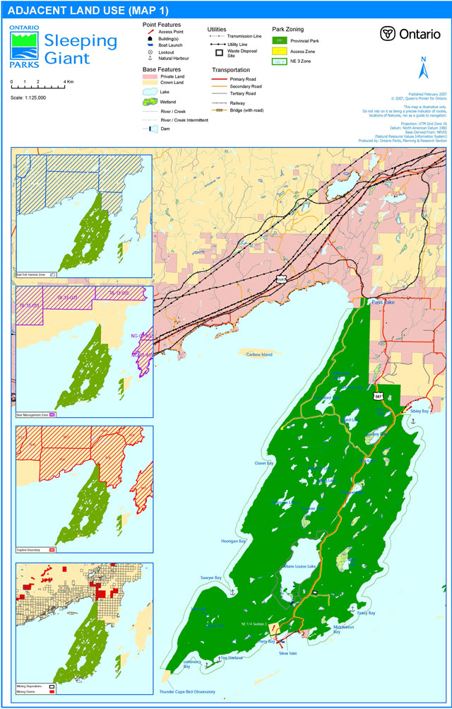
Figure 3 - Park zoning and development
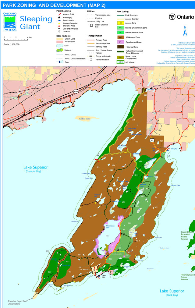
Figure 4 - Zoning and development - Marie Louise Lake and Silver Islet
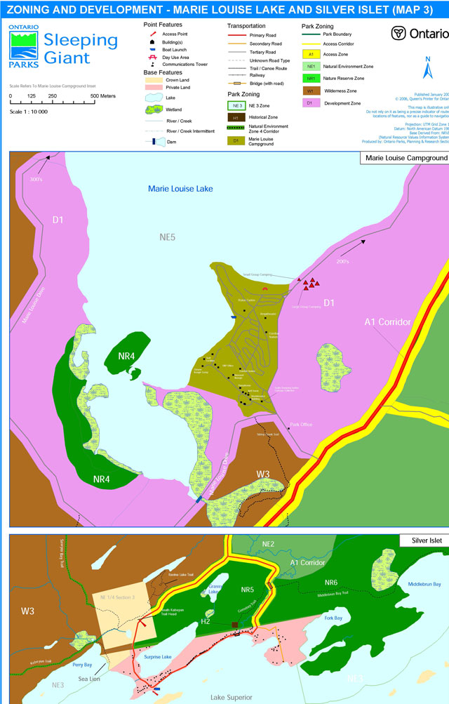
Footnotes
- footnote[1] Back to paragraph OMNR designates bald eagle (Haliaeetus leucocephalus) as endangered, and the peregrine falcon (Falco peregrinus) as endangered as of 01-Mar-00.
- footnote[2] Back to paragraph Sleeping Giant Park Management Plan has been developed in accordance with the Ontario Provincial Parks Planning and Management Policies (1992), Ontario’s Living Legacy Land Use Strategy (1999) and District Land Use Guidelines for the Ministry of Natural Resources Thunder Bay District (1983). In accordance with this plan, MNR will amend affected area-specific land use policies and mapping found in the Crown Land Use Policy Atlas: /page/crown-land-use-policy-atlas.
- footnote[3] Back to paragraph The Crown Land Use Policy Atlas (CLUPA) is MNR's repository of existing local land use policies for Crown lands in the central part of Ontario, including provincial parks. Amendments to the policy reports and mapping of the CLUPA will be completed to reflect the direction of this park management plan.
- footnote[4] Back to paragraph Bioprospecting is the collecting of biological samples (plants, animals, micro-organisms) and the collecting of indigenous knowledge to help in discovering genetic or biochemical resources. Bioprospecting is intended for economic purposes (e.g., new drugs, crops, industrial products).
- footnote[5] Back to paragraph 2. (1) No person shall, (a) remove, damage or deface any property of the Crown; or (b) damage or deface any relic, artefact or natural object or any site of archaeological or historical interest, within a provincial park. R.R.O. 1990, Reg. 952, s. 2.