Smokey Head-White Bluff Provincial Park Management Statement
This document provides policy direction for the protection, development and management of Smokey Head-White Bluff Provincial Park and its resources.
March 1, 1997
Approval statement
This Interim Management Statement will provide interim direction for the custodial management of Smoky Head - White Bluff Provincial Nature Reserve until such time as a comprehensive Park Management Plan is prepared.
This statement will provide the basis for the subsequent preparation of the Park Management Plan.
I am pleased to approve the Smoky Head - White Bluff Provincial Nature Reserve Interim Management Statement.
Additional copies of this document are obtainable from:
Park Superintendent
MacGregor Point Provincial Park
R.R. #1
Port Elgin, Ontario N0H 2C5
Signed by:
Peter Sturdy, Zone Manger
Southwestern Parks Zone
Ontario Parks
Background information
| Name: | Smoky Head - White Bluff Provincial Nature Reserve |
|---|---|
| Class: | Nature Reserve |
| MNR Parks Zone: | Southwestern, London |
| MNR Region/District: | Southcentral/Midhurst |
| Total Area: | 346.7 ha. (regulated) |
| Site District: | 6 - 14 |
| Regulation: | Ont. Reg. 45/85 |
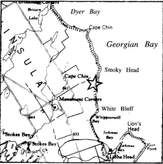
Regional setting map
Targets
1. Life science representation (provincial significance)
| Site Type/Landscape Unit | Feature |
|---|---|
| Niagara Escarpment Slopes and Georgian Bay Shore Bedrock Plain |
Post-fire successional broadleaf, mixed and conifer forests, with a boreal element; unusually rich Sugar Maple forests; open block talus shores with rare shoreline species; and dry open talus and exposed cliffs and old-growth White Cedar treed cliff rim. |
2. Earth science representation (regional significance)
| Geological Theme | Feature |
|---|---|
| Lower-Middle Silurian Late Wisconsinan (Pleistocene - Holocene) |
Cobble beaches, coarse blocky talus slopes, tall cliffs, upland areas with predominantly shallow soils over rolling dolostone bedrock (ancient reef complex), escarpment plain, potholes. |
3. Cultural resources representation
| Theme | Theme Segment |
|---|---|
| Agriculture and Agricultural Communities Forest Industries and Forest Industry Communities |
Settlement of Bruce Peninsula Upper Great Lakes Fisheries Georgian Bay Lumbering |
4. Recreational opportunities
| Day Use | Vehicle Camping | Back Country |
|---|---|---|
| Hiking (Bruce Trail) Cross-country Skiing Snowshoeing Nature Appreciation |
n/a | Bruce Trail Overnight Rest Area Proposed |
Inventories
| Level/Type | Earth Science | Life Science | Cultural | Recreational | Other |
|---|---|---|---|---|---|
| Check Sheet | Blachut, 1977 | Cuddy, 1976 Varga, 1994 |
|||
| Reconnaissance | Varga, Jalava, Kor, Larson, 1992 | (required) | (trail plan required) | ||
| Detailed | (required) | Varga, Jalava, Larson, 1994 |
Management guidelines
I. Land tenure
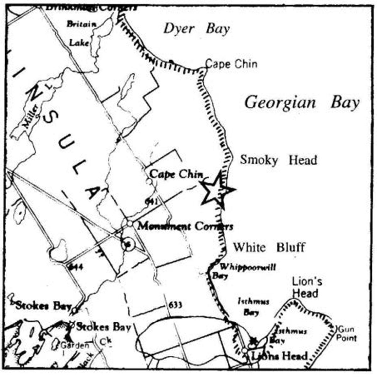
Smoky Head - White Bluff Provincial Nature Reserve is located on the Bruce Peninsula on Georgian Bay approximately six kilometres north of the community of Lion’s Head. A total of 346.7 hectares (856.7 acres) have been acquired and regulated under the Provincial Parks Act in the Township of Lindsay, in Bruce County (see Figure 1).
Acquired Crown land associated with Smoky Head - White Bluff consists of parts of Lots 11, 12, 13 and 14, Concession 9, East of Bury Road (EBR), Township of Lindsay, the plan of subdivision (R-172) in part of Lots 7, 8 and 9, Concession 9, EBR, and part of Lot 41, Concession 6, EBR, Township of Eastnor. In The Forty Hills/White Bluff area the Bruce Trail Association (BTA) holds title to Part Lot 1, Concession 7, EBR, Township of Lindsay, and part or all of lands in Lots 39 through 44, Concession 5, EBR, Lots 39 through 43, Concession 6, EBR, and Lots 43 and 44, Concession 7, EBR, in the Township of Eastnor (Figure 1). It is proposed that acquired Crown lands and portions of the Bruce Trail Association (BTA) lands eventually become additions to the Nature Reserve.
No land use permits or leases presently exist within the Nature Reserve.
The Nature Reserve is a part of the Niagara Escarpment Parks and Open Space System and is classified as a Nature Reserve in the Niagara Escarpment Plan. Under that Plan, the applicable land use designations for the immediate area are: Escarpment Natural Area, Escarpment Protection Area, Escarpment Rural Area, and Escarpment Recreation Area.
Guideline:
Subject to the status of the local Native land claim negotiations and/or a shift in government policy, no additional acquired Crown lands shall be regulated as part of the Nature Reserve.
A housekeeping amendment may be processed to correct the regulated name of the Provincial Nature Reserve (i.e., "Smokey" to "Smoky").
II. Land acquisition and disposition
Land acquisition in the Township of Lindsay is substantially complete except for intervening or abutting (untravelled) municipal road allowances.
The BTA may eventually lease or transfer title of portions of its holdings in The Forty Hills/White Bluff area to the province, to be managed by Ontario Parks, Ministry of Natural Resources (MNR). The transfer may include two easement or right-of-way agreements allowing landowners access to their properties.
Figure 1: Smokey Head - White Bluff Provincial Nature Reserve
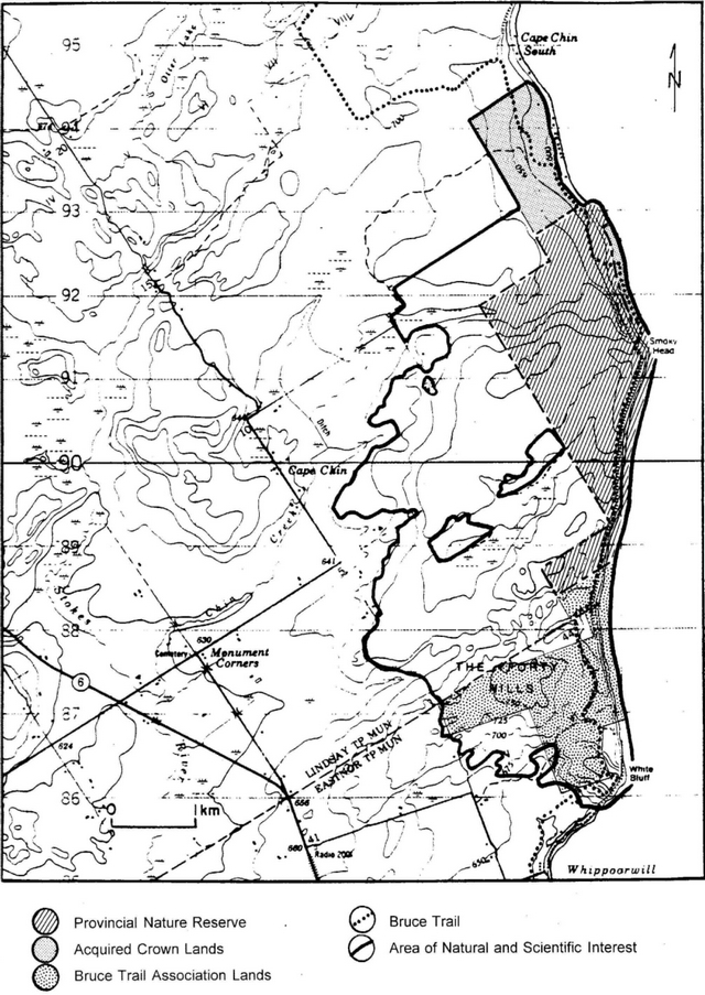
Enlarge Figure 1: Smokey Head - White Bluff Provincial Nature Reserve
Guidelines:
Land acquisition by the province (including untravelled municipal road allowances) may proceed to consolidate provincial holdings, to facilitate management and to protect significant natural or cultural features. Lands will be acquired on a willing seller - willing buyer basis as opportunities arise, subject to the availability of funding.
Bruce Trail Association lands may be secured and managed by Ontario Parks as an addition to the Nature Reserve.
Acquired Crown lands, through time, may be regulated under the Provincial Parks Act subject to the status of Native land claims negotiations and/or government policy, no disposition of any surplus Crown land will occur.
III. Existing and proposed development
The Bruce Trail travels through the length of the Nature Reserve (see Figure 1) with two minor reroutes; one just south of the Cape Chin South Road and the other south of the boundary between Lindsay Township and Eastnor Township. There is an overnight rest area (ORA) which is currently located at Reed’s Dump. As a condition of the transfer of its lands to the province, the BTA wishes to relocate the ORA from Reed’s Dump to the open land in Lot 42, Concession 6, EBR, Township of Eastnor.
At the terminus of the gravel road extending south of the cottages at Cape Chin South there are two parking spaces for Bruce Trail hikers.
Guidelines:
The Peninsula Bruce Trail Club will be responsible for maintaining the Smoky Head - White Bluff portion of the Bruce Trail and related facilities. The proposed optimum Bruce Trail route should be based on recommendations in the Life Science Inventory report (see references - Varga, Jalava, Larson, 1994). A Bruce Trail Overnight Rest Area may be accommodated on lands leased or transferred from the BTA.
A five vehicle parking area may be established adjacent to Cape Chin South Road, following acquisition and gating of the gravel access road.
Interpretive panels/stations may be installed at suitable points along the Bruce Trail and/or at access points into the Nature Reserve.
Appropriate signs, fences, gates and barriers may be installed as required to control access onto acquired Crown lands and the regulated Nature Reserve and thus to prevent damage to sensitive features within these areas.
IV. Recreation activities
Hiking, cross-country skiing, snowshoeing, picnicking, and nature/historical appreciation are recreational activities permitted in the Nature Reserve.
Guidelines:
Sport hunting will not be permitted.
Horseback riding and mountain biking will not be permitted.
Non-conforming recreational activities will be discouraged through public education, posted signs, and, if necessary, enforcement.
A Trail Implementation Plan shall be prepared prior to establishment of the proposed optimum Bruce Trail route.
Recreation programs will not be promoted.
V. Commercial activities guideline:
No commercial forest management operations, fishing, bait fishing or trapping will be permitted in the Nature Reserve.
VI. Natural resources
Life Science - The provincially significant life science Area of Natural and Scientific Interest has a 9.4 kilometre long escarpment slope, and associated plain, containing diverse vegetation types. It is one of the longest undeveloped escarpment slopes on the Bruce Peninsula south of Cabot Head. The escarpment plain has an exceptional intermingling of northern and southern forest types and a noteworthy reef complex landscape at The Forty Hills. The diverse flora and fauna include 9 nationally and/or provincially rare, 38 regionally rare, and 19 locally significant species, as well as old growth Eastern White Cedars (Varga, Jalava, Larson, 1994). Also the nationally and provincially threatened Massasauga Rattlesnake exists within the area.
Earth Science - At the promontories of White Bluff and Smoky Head, the escarpment slopes rise up to 65 metres (200 feet) above Georgian Bay. These slopes are topped by the dolostone cliffs of the Amabel Formation, the cap rock of the Niagara Escarpment. The slopes consist of talus eroded from the main cliff-face and intermittent dolostone cliffs of the Fossil Hill Formation. Back from the escarpment rim, an extensive escarpment plain varies from relatively flat bedrock in the site’s northern portion to the rocky knolls of The Forty Hills in the southern half of the site. The Amabel Formation forms most of the bedrock, with the higher dolostone knolls being ancient bedrock reefs of the Guelph Formation (Jalava, Varga, Riley, 1995).
Guidelines:
A detailed earth science study should be completed prior to preparation of a Park Management Plan.
The biological impacts of the Bruce Trail will be periodically monitored. Sensitive areas will be avoided in any trail related development. Other activities having a negative impact upon natural values will not be permitted.
Approved land acquisition should continue in the area to protect significant natural values.
VII. Cultural resources
- Pre-history - Archaeological evidence dates the earliest human occupation of Smoky Head - White Bluff to the arrival of the Amerindians nearly 2,500 years ago. The Bruce Peninsula was originally settled by the Odawa of Algonquin background.
- History - In 1616, Samuel de Champlain visited the Bruce Peninsula. Logging and fishing became the predominant activities in the late 1800's.
Guideline:
Both archaeological and historical reconnaissance surveys would serve to further document the cultural values of the local area. These surveys may be completed prior to preparation of a Park Management Plan.
VIII. Natural heritage education
Guidelines:
A fact sheet on the Smoky Head - White Bluff Life Science Area of Natural and Scientific Interest will be updated, reproduced, and made available to the public as required.
Interpretive panels/stations may be established at suitable points along the Bruce Trail and at access points to the Nature Reserve.
IX. Native interests
Guideline:
Subject to the status of local Native land claim negotiations and/or government policy, the status of provincially owned lands associated with the Nature Reserve will not be changed.
X. Marketing
Guidelines:
A marketing plan will not be required.
This Provincial Park will not be promoted aside from general information provided in the fact sheet and as identified in information presented to the public regarding the Niagara Escarpment Parks and Open Space System and the Bruce Trail Reference.
XI. Research
Guideline:
Appropriate research or inventory projects will be encouraged, and directed particularly to subject areas required to assist in preparation of a Park Management Plan and to assist in identifying and protecting sensitive natural features or cultural resources in the local area.
XII. References
Blachut, S. Cape Chin Special Area Earth Science Inventory Checklist. Ontario Ministry of Natural Resources, Division of Parks, Parks Planning Branch, 1977.
Bracken, M., Barnes, J., and Oates, C. The Escarpment - A Climber’s Guide. Borealis Press, Toronto, 1991.
Bruce Trail Association. Bruce Trail Reference, 19th Edition. Hamilton, 1994.
Cowell, D.W., and Woerns, N. Earth Science Candidate Nature Reserves in the Niagara Escarpment Planning Area. Ontario Ministry of Natural Resources, Division of Parks, 1976.
Cuddy, D.G. Smokey Head - White Bluff Life Science Inventory Checklist. Ontario Ministry of Natural Resources, Division of Parks, Parks Planning Branch, 1976.
Cuddy, D.G., Lindsay, K.M., and Macdonald, I.D. Significant Natural Areas Along the Niagara Escarpment. Ontario Ministry of Natural Resources, Parks Planning Branch, 1976.
Jalava, J.V., Varga, S., and Riley, J.L. Ecological Survey of the Niagara Escarpment Biosphere Reserve (Preliminary). Ontario Heritage Foundation and Ontario Ministry of Natural Resources, 1995.
Niagara Escarpment Commission. Niagara Escarpment Plan. Ontario Ministry of Environment and Energy, Toronto, 1994.
Ontario Ministry of Natural Resources. Ontario Provincial Parks Management Planning Manual. Provincial Operations Branch, Peterborough, 1994.
Ontario Ministry of Natural Resources. Ontario Provincial Parks: Planning and Management Policies, 1992 Update. Provincial Parks and Natural Heritage Policy Branch, Toronto, 1992.
Ontario Ministry of Natural Resources. Owen Sound District Land Use Guidelines. Owen Sound District, Owen Sound, 1983.
Ontario Ministry of Natural Resources. Smokey Head - White Bluff Life Science Area of Natural and Scientific Interest Fact Sheet. Owen Sound District Office, 1994.
Varga, S., Jalava, J., Kor, P.S.G., Larson, B. Reconnaissance Survey of the Vegetation, Fauna and Landforms of the Bruce Trail Association Forty Hills Property, Bruce County. Ontario Ministry of Natural Resources, Southern Region, 1992.
Varga, S., Jalava, J.V., and Larson, B. Biological Inventory and Evaluation of the Smokey Head - White Bluff Provincial Nature Reserve and Area of Scientific Interest. Ontario Ministry of Natural Resources, Southern Region, Aurora, 1994.