St. Raphael Provincial Park Management Statement
This document provides policy direction for the protection, development and management of St. Raphael Provincial Park and its resources.
Interim Management Statement
©2001, Queen’s Printer for Ontario
Additional copies of this publication can be obtained only from:
Ministry of Natural Resources
Sioux Lookout District Office
Prince Street
PO Box 309
Sioux Lookout, ON
P8T 1A6
Telephone: 807-737-1140
or:
Ontario Parks Northwest Zone
Suite 221D
435 James Street South
Thunder Bay, ON
P7E 6S8
Telephone: 807-475-1321
Approval statement
This Interim Management Statement will provide interim direction for the management of St. Raphael Provincial Park until a comprehensive Park Management Plan is prepared.
This statement will provide the basis for the subsequent preparation of the Park Management Plan.
I am pleased to approve this Interim Management Statement for St. Raphael Provincial Park.
Signed by:
Tim P. Sullivan
Zone Manager, Ontario Parks
North West Zone
Prelude
The purpose of this Interim Management Statement is to identify:
- park values, which are to be protected
- resource management prescriptions necessary to protect these values in their current state; and
- restrictions, according to existing park policy, on use of natural resources within the park
This Interim Management Statement is not intended to replace a Park Management Plan. Rather it is intended to guide the use of natural resources and related activities within the park until such a time as a Park Management Plan is prepared.
The guidelines that have been developed are based upon information contained in the Ontario Provincial Parks Planning and Management Policies (1992) and Ontario’s Living Legacy Land Use Strategy (1999).
Background information
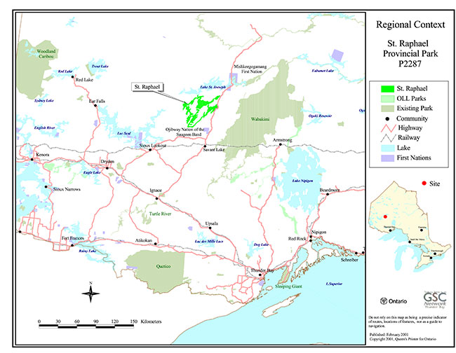
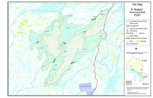
Refer to the maps at the end of the document.
| Name: | St. Raphael Provincial Park |
|---|---|
| Classification: | Waterway |
| MNR District: | Sioux Lookout |
| MNR Region: | Northwest |
| Total Area (ha): | 89 097 |
| Site Region: | 3S |
| Site District: | n/a |
| Date in Regulation: | 2001 (target) |
Targets
Life science representation
| site type / landscape unit | species / communities |
|---|---|
|
|
Earth science representation
| geological theme | feature(s) |
|---|---|
|
|
Cultural resource representation
| cultural resource representation | theme segment |
|---|---|
| n/a | n/a |
Recreational opportunities
| day use | car camping | wilderness/backcountry |
|---|---|---|
| Hunting / Angling Opportunities, Wildlife Viewing, Swimming, Nature Appreciation, Snowmachine Travel | n/a | Canoe Routes, Commercial Outpost Based Fishing and Hunting , Berry and Mushroom Picking |
Inventories
| level/type | reconnaissance / completion date | detailed / completion date | Required |
|---|---|---|---|
| earth science | February 16, 2001 -draft | Detailed Required | |
| life science | February 16, 2001 -draft | Detailed Required | |
| cultural | Yes | ||
| recreational | March 2001 (target) | No | |
| other |
I. Introduction
St. Raphael Provincial Park was established as part of Ontario’s Living Legacy, a land use strategy that guides the planning and management of Crown lands in central, and portions of northern Ontario. Under this initiative, released in July 1999, 378 new protected areas were identified. St. Rachael Provincial Park is designated as part of a Signature Site in this land use strategy and as such forms part of this significant expansion of Ontario’s protected areas system.
Using the NAD 27 UTM coordinate system, St. Raphael Provincial Park is located within UTM Zone 15 and is roughly bounded by 5590500 mN, 621200 mE, 5647850 mN, and 679800 mE. As a waterway class park, St. Raphael includes various watercourses, as well an area bordering them which ranges between 25 to 2000+ meters in width. Some of the larger lakes included entirely within the park are: Churchill Lake, De Lesseps Lake, Hooker Lake, Lawson Lake, Minchin Lake, Miniss Lake, St. Raphael Lake, and Vincent Lake.
II. Land tenure/acquisition/disposition
St. Raphael Provincial Park is all Crown Land. There is a Crown Lease (No. 3875) for land located on De Lesseps Lake which is occupied by Guardian Eagle Resort who operate a 5 star facility at that location. Neighboring this resort is an airstrip which services the resort, authorized through a Crown Land Use Permit (LUP 5007). Also nestled within the park is a patch of private land (Parcel # 36099), located on Hooker Lake, which is occupied by a main base camp of Hidden Bay Lodge. Land use permits exist for six other outpost camps (16-00867, 16-00370, 16-00819, 16-00883, 16-00882, 16-00868) located on park land. Aside from the section where Highway # 599 runs adjacent to the park’s eastern border (near Minchin Lake), the land immediately adjacent to the outer borders of St. Raphael Provincial Park is all owned and managed by the Crown. Highway # 599 is administered by the Ontario Ministry of Transportation.
The Miniss Enhanced Management Area (EMA) consists of three separate land parcels, two of which are entirely surrounded by St. Raphael Provincial Park. Ontario’s Living Legacy Land Use Strategy (OMNR 1999) indicates that the Miniss EMA was created with the intent to carry out forest management activities while giving special consideration to tourism activities that are consistent with policy. Forest roads and areas of active timber harvest are to be kept to a minimum within this EMA (OMNR 1999).
Guideline:
- No land disposition for the private use of individuals or corporations will be considered within the park
- Dispositions for uses associated with activities permitted in this IMS will be considered
- If any portion of adjacent lands become available they will be considered for addition to the park
- Activities related to commercial uses are addressed in Section VIII – Commercial Activities
III. Aboriginal interests
St. Raphael Provincial Park is within the boundaries of lands covered under the James Bay Treaty Treaty 9, and Treaty 3 between Her Majesty the Queen and the Saulteaux Tribe of the Ojibway Indians at the Northwest Angle on the Lake of the Woods with Adhesions. The Ojibway Nation of the Saugeen Band (Treaty 3) is located approximately 15 kilometers east of the park boundary at Lawson Lake, while the Mishkeegogamang First Nation (Treaty 9) is located approximately 12 kilometers north of the park boundary at Medcalf Lake (Figure 1). It is likely that the park includes traditional use areas for both of these First Nations, however, very little information is available regarding such park values. There are no land claims regarding St. Raphael Provincial Park at this time.
Guideline:
- Any management guidelines will reflect the Ontario government’s approach to aboriginal rights:
- All decisions related to the identification, planning or disposition of provincial park lands, or other lands set aside to protect significant natural or cultural heritage values, will be the subject of public Aboriginal peoples who identify traditional ties to those lands will be integral to the consultation and decision making processes. In some cases there may be a need for separate consultation or negotiation processes to address Aboriginal interest in park lands. If required, some issues regarding how a park is used may also be the subjects of negotiation with Aboriginal people
- The Government of Ontario will consider all the available options when seeking to determine the land component, if any, during negotiations involving land claim settlements with First Nations. Options for uses that involve lands which are not to be considered for provincial park purposes will be preferred
- As described in the Province’s Interim Enforcement Policy (1991), aboriginal people hunting or fishing in provincial parks will be subject to all relevant treaties and However, an agreement reached between the Province and a First Nation may modify the application of those treaties and laws. (Ontario Provincial Parks Planning and Management Manual 1992)
IV. Natural Resource Stewardship
St. Raphael Provincial Park is located in Hills Site Region 3S (Hills 1964 revision map), and in the Upper English Section (B.11) of the Boreal Forest Region (Rowe 1972). The Upper English River Section represents part of the Great Lakes St. Lawrence Forest- Boreal Forest transition zone (Rowe 1972). Black spruce, white spruce, jack pine, balsam fir, white birch, and trembling aspen are common canopy species. White pine and red pine occur as scattered individuals, or isolated clumps, and they reach the northern limits of their range in this section (Rowe 1972). Forest soils here are generally thin (Rowe 1972), and in many places exposed bedrock results in sparse canopy cover.
The granite bedrock of St. Raphael Provincial Park is from the early Precambrian (Early to mid-Archean) period which occurred between 2.5 and 3.4 billion years ago. This bedrock is contained in both the Wabigoon, and English River subprovinces of the Superior Geological Province. At the junction of these two subprovincies lays the northeast tending Miniss River Fault. Blackburn et al. (1991) indicates that this fault is transcurrent, and a subprovince marginal fault that makes up the northern extension of the Vermilion Fault. Its presence is not strongly visible at the surface, but may be inferred by examination of adjacent rock ages. The most visible feature of this fault is its hydrological control of the Miniss River and some lake shores (Cowell 2000). Although this fault is of scientific, educational, and interpretative value, its obscure nature suggests that it should be ranked only at the regional level of significance pending further field investigation.
The geological characteristics of St. Raphael Provincial Park would suggest that there is some potential for tantalum in the pegmatite rock units associated with the area north of, and partially including, the northern section of the park (near Lawson Lake and Medcalf Lake). Used in the electronics industry, the value of tantalum has increased substantially in recent years. The mafic intrusive rock east of Hooker Lake is known as the Hooker Lake Stock and it has a moderate potential for platinum group elements (Rhodium, Palladium, Platinum, Iridium, Osmium, Rhenium), nickel, and copper (Abraham Drost, 2001). Field assessment of the minerals present within the St. Raphael Provincial Park area has been limited to a 1976 airborne magnetometer survey by Union Miniere Exploration (east of Hooker Lake), and two drilled holes in iron formation by INCO in 1968 (East of St. Raphael Lake).
i. Lands and waters
The topography of St. Raphael Provincial Park features weakly broken bedrock that is mantled, or flanked, by silty sandy till. Characteristic features of such areas include eskers, drumlins, and ground moraines. The drumlin features between Minchin and De Lesseps Lakes, as well as various eskers throughout the park are possibly of regional significance. There are a relatively low number of shallow bays and lowlands in general within the park. This feature contributes to the low level of wetland habitat representation in the area. St. Raphael Provincial Park provides excellent examples of ongoing shoreline processes in Canadian Shield Lakes and as such displays active lakeshore bars, re-curved spits, tombolos, and wide sand beaches. These features are especially evident in Medcalf, Hooker, and Vincent Lakes where they are possibly of provincial significance.
Currently, there are no patent mining claims, or aggregate extraction permits issued for land located in St. Raphael Provincial Park.
Guideline:
- Aggregate extraction is not permitted
- Peat extraction is not permitted
- Commercial hydro development is not permitted
- The need for any water control structures to enhance recreational opportunities will be considered during the park management planning process provided there will be no conflicts with natural or cultural values
- Mineral exploration may occur under controlled conditions in portions of the park that are identified through further analysis and consultation as having provincially significant mineral potential. If part of a new park is to be developed for a mine, it would be deregulated as part of the park, and appropriate replacement lands would be placed in regulation
ii. Fish and wildlife management
St. Raphael Provincial Park contains significant habitat for woodland caribou, moose, wolf, wolverine, black bear, pine marten, lynx, bald eagles, osprey, and various waterfowl species. Park lakes and rivers support yellow pickerel (walleye), northern pike, yellow perch, whitefish, and lake trout populations all of which are harvested through recreational angling. There are a total of eleven registered traplines, seventeen baitfish blocks, and twelve bear management areas associated with St. Raphael Provincial Park (see Section VIII - Commercial Activities). Wildlife Management unit 16B encompasses the entire park. For fisheries management St. Raphael Provincial Park sits in Northwestern Ontario, Division 31.
Guideline:
- Non-invasive wildlife monitoring may be permitted
- The need for a Fisheries and/or Wildlife Management Plan will be resolved in the park management plan
- Sport fishing in St. Raphael Provincial Park is permitted subject to the relevant Ontario Sport Fishing Regulations
- The possession/use of baitfish for sport fishing is a non-conforming use as park policy states it is prohibited. Decisions on this issue will be determined during park management planning
- Sport hunting is permitted in Natural Environment zones, as determined through park management planning and subject to the relevant Ontario Hunting Regulations. Consideration of safety and conservation with respect to hunting will be made during park management planning with public involvement
- Aboriginal and Treaty rights to fish and trap are not affected
iii. Vegetation management
A wide variety of forest and wetland communities are present in St. Raphael Provincial Park. Jack pine, jack pine/black spruce, white birch, white birch/trembling aspen, and mixedwood forest of black spruce, white spruce, white birch, and trembling aspen all commonly occur on upland areas. In low areas black spruce swamps, fens, and marshes are all represented, however, such habitat is relatively infrequent in relation to park size. There is a stand of red pine which includes several old growth pockets on the shores of Hooker Lake. This stand is of provincial significance due to its age, purity, and location north of normal range limits for red pine. Also, the occurrence of horizontal juniper (Juniperus horizontalis) in the wetland area south of Medcalf Lake, an area referred to as the Medcalf Peatland in Noble (1995a), is probably of at least regional significance.
Forest fires have helped shape the vegetative communities in St. Raphael Provincial Park. In 1996, a substantial portion of the park at the northeast end of Miniss Lake was burned. Several other less recent fires have also influenced vegetation throughout the park. Under the existing Fire Management Strategy for Ontario, this park is within the Intensive Zone. The province is in the process of redeveloping their fire management strategy, and as a result, this zone designation will change. The level of protection in the St. Raphael Provincial Park area will, however, be maintained to the same levels as with the existing strategy (Jackson 2001). Once developed the Park Management Plan, along with supporting vegetation and fire management plans, will outline the role of fire management within St. Raphael Provincial Park.
St. Raphael Provincial Park is surrounded by land which is managed primarily under the Caribou Forest Sustainable Licence (SFL # 542481), however, a small portion is managed under the Lac Seul Sustainable Forest Licence (SFL # 542455). Twenty year forest management plans are produced for both of these forests every 5 years. Currently, a Forest Management Plan (FMP) covering the period 2002-2022 for the Caribou Forest is under development; with an expected implementation date of April 1, 2002. A Forest Management Plan covering the period 2001-2021 for the Lac Seul Forest has recently been approved with an implementation date of April 1, 2001.
Guideline:
- Commercial forest operations are not permitted
- Fuelwood cutting is not permitted
- Insect/disease suppression of non-native infestations is permitted
- Suppression of natural and/or human-caused forest fires using light on the land techniques is permitted
- The need for a Vegetation Management plan, which could include prescriptions for natural and accidental fire management, will be determined in the park management plan
- Access routes through St. Raphael Provincial Park for the purposes of conducting forest management operations within the Miniss Enhanced Management Area is covered in Section VI – Existing/Proposed Development, and Section IX – Access
V. Cultural resources
Very little is known about the cultural resources of St. Raphael Provincial Park. It has been suggested that pictographs are associated with Lawson Lake, and record of a traditional meeting area within park boundaries exists. It is likely that the area was used extensively by ancestors of both the Mishkeegogamang First Nation, and the Ojibway Nation of the Saugeen Band, before and after European contact. There may be a rich cultural history for the park from these times.
Guideline:
- Further inventory work to assess the cultural resources of St. Raphael Provincial Park will be undertaken as funds become available
- Aboriginal cultural values will be obtained from First Nations as opportunities become available
- Approved archeological fieldwork will be encouraged
- The locations of any archeological sites will not be public information. Necessary measures (access/development restrictions) to protect the integrity of any archeological sites will be implemented
- The need for a Cultural Resources Plan/Strategy for cultural features/sensitive areas will be determined with park management planning
VI. Existing/proposed development
Currently development within St. Raphael Provincial Park includes: 10 trapper’s cabins, one tourist main base lodge, an airstrip, 6 tourist outpost camps, various privately maintained portages (without public funds), four commercial boat cashes (2 boats on Ghost Lake, 1 boat on Spirit Lake, 4 boats on St. Raphael Lake, and 3 boats on Lawson Lake), and one road access point at Minchin Lake. There is also a winter trail running from Highway # 599, over Minchin Lake, and to De Lesseps Lake for access to the Guardian Eagle Resort. This resort is a 5 star facility on land held under a Crown Lease. It appears that this winter road/trail was used primarily during resort establishment. St. Raphael Provincial Park surrounds private land on Hooker Lake which is used for a main base camp by Hidden Bay Lodge. Also, Highway #599 is immediately adjacent to the eastern boundary of St. Raphael Provincial Park for 18 kilometers near Minchin Lake.
There are intentions to develop up to six road crossings of St. Raphael Provincial Park for the purposes of timber extraction from the Miniss Enhanced Management Area (EMA) (Figure 2). OMNR (1999) indicates that roads within this EMA, "will be kept to a minimum, developed at the lowest standard possible, closed to public travel, and physically abandoned when no longer required for forestry purposes". Certain roads within these access corridors may be required for Forest Management activities on a permanent basis (greater than 100 years). Subsequently, it is necessary for Ontario Parks to consider these purposed park road crossings as possible permanent development of park land. As such, the influence of these proposed crossings should be evaluated from a parks perspective before their establishment and will require the appropriate site evaluation and park planning processes.
Guideline:
- Road crossings of the park will be minimized and managed to limit their impact on the recreational and aesthetic values
- Access roads not used for parks purposes and not intended for use in the Forest Management Planning cycle (20 years) will be removed, rehabilitated, and regenerated
- Development of new/additional roads for the purposes of park access will be determined through park management planning
- Boat caches fall under existing policy of land disposition. Currently, boat caches for the private use of individuals will be phased out by Jan 1, 2010. Dispositions for commercial tourism can be permitted if they are complementary to the park objectives, and if supported by public consultation via the management planning process
- Development of campsites, portages, and hiking trails will be addressed via park management planning
- Ontario Parks' signage is permitted
- The use of snowmachines / all-terrain vehicles is covered under Section VII - Recreational Activities and Section VIII - Commercial Activities
- The use of roads for forest management operations within the Miniss Enhanced Management area is covered in Section IX – Access
VII. Recreation activities
The most common recreational uses of St. Raphael Provincial Park currently include sport fishing, sport hunting, motorized boating, wildlife viewing, swimming, and canoe tripping. In addition there is a limited amount of mushroom picking, berry picking, and archeology related activities. During winter months there is also some recreational snowmachine use in the park.
Guideline:
- Park management planning will determine policies for recreation management, including backcountry camping and canoeing
- Motorized boat use in the park is permitted to continue subject to management prescriptions determined through park management planning
- Self-guided nature appreciation and wildlife observation is permitted
- Use of snowmachines/all-terrain vehicles on pre-existing (authorized) trails is permitted to continue subject to management prescriptions determined through management planning
- Development of new trails as well as appropriate uses will be considered, where consistent with policy, during park management planning
- Existing, unauthorized, snowmobile trails can continue subject to management prescriptions to be determined through management planning. Management planning will also review these trails in the context of park objectives with the intent to permit snowmobile trails within access zones. Routes located outside of future access zones will be evaluated to determine alternative route locations
- Sport fishing and hunting are addressed in Section IV – Natural Resource Stewardship
- Access related issues (i.e. winter roads), are addressed in Section IX – Access
VIII. Commercial activities
A total of eleven commercial traplines (SL80-170, SL80-171, SL80-172, SL80-173, SL80-182, SL80-183, SL92-162, SL92-163, SL92-164, SL96-143, SL96-144) are wholly or partially covered by St. Raphael Provincial Park. These traplines are held by 10 different operators with one trapline currently in the process of changing holders.
The twelve Bear Management Areas that include portions of the park are: SL-16B-006, SL-16B-007, SL-16B-009, SL-16B-011, SL-16B-012, SL-16B-013, SL-16B-014, SL-16B-015, SL-16B-025, SL-16B-033, SL-16B-035, SL-16B-036. Five outpost camp operators hold seven of these permits, three (SL–16B-006, SL-16B-007, and SL-16B-015) are currently available for issue, and two (SL-16B-035 and SL-16B-036) will not be re-issued.
Seventeen baitfish blocks are located entirely or partially within the park and these are: 504904, 504911, 505904, 505911, 506903, 506904, 506911, 506912, 507902, 507903, 507904, 507911, 507912, 508902, 508903, 508904, 508911. These baitfish blocks are licenced to a total of 6 holders.
No commercial fishing operations occur in the park.
St. Raphael Provincial Park is adjacent to land currently managed under the Caribou Forest Sustainable Forest Licence held by Bowater Incorporated, and the Lac Seul Sustainable Forest Licence held by Mackenzie Forest Products Incorporated.
Six outpost camps occur on park land; Miniss Lake (3 camps), Churchill Lake (1 camp), Arc Lake (1 camp), and St. Raphael Lake (1 camp). Guardian Eagle Resort operates a 5 star facility in St. Raphael Provincial Park (Crown Lease No. 3875) on De Lesseps Lake. Associated with this resort is an airstrip (LUP 5007) also within the park. On Hooker Lake, Hidden Bay Lodge operates a main base camp on private land surrounded by the park.
Guideline:
- Existing trapline operations can continue indefinitely except in Nature Reserve zones as determined through park management planning. No new operations are permitted including new cabins, trails, and reissuing vacant or lapsed trap lines. Transfer may take place if the surrender is accompanied by a request to be immediately reissued
- Snowmobile trails used for access to trap lines are permitted
- Status Indians exercising treaty rights are permitted to continue trapping, subject to applicable legislation and regulation
- No new BMA's will be permitted. Existing BMA's may be renewed or transferred except in nature reserves, and wilderness zones where this activity is not permitted. Park management planning will address renewal and transfer of BMA's as they relate to conservation principles, and public safety
- Existing bait harvesting is permitted to continue indefinitely, subject to possible conditions identified in subsequent Provincial Park and / or Fisheries Management Plans. No new baitfish harvesting licenses will be permitted, but the active license may be transferred where this is already an established permitted use
- Commercial forest operations are not permitted
- Existing authorized tourism facilities may continue subject to management prescriptions determined through park management planning. New tourism facilities and expansion of existing facilities may be considered through the management planning process
IX. Access
Motor vehicle access into St. Raphael Provincial Park is restricted to a small boat launch at Minchin Lake, and a developed winter trail which runs from Highway # 599 over Minchin Lake and to De Lesseps Lake. Boat access to the park is also attained where Pashkokogan Lake bisects with Highway # 599. From this location boats are launched into Pashkokogan Lake and are taken into Medcalf Lake which has a southern shore that is part of the park. Canoes are also commonly launched at three points near Minchin Lake (Pashkokogan River, East Minchin Lake, and South Minchin Lake. Three other recognized canoe routes enter the park at: Lake St. Joseph (Miniss Bay), Miniss River from Armit Lake, and Spirit Creek south of Spirit Lake. Aside from these locations, access into St. Raphael Provincial Park is attained primarily by air travel.
There are intentions to develop up to six road crossings of the park for the purposes of forest management within the Miniss Enhanced Management Area (EMA). These proposed park crossing locations are:
- South De Lesseps Lake – North Lawson Lake (Land Crossing)
- Southeast Miniss – North De Lesseps (Water Crossing)
- South Miniss Lake – North Arc Lake (Water Crossing)
- Between Vincent Lake and Ghost Lake (Land Crossing)
- South Churchill Lake – North St. Raphael (Water Crossing)
- South Medcalf Lake (Land Crossing)
Guideline:
- Access into the park from existing roads will be permitted to continue pending park management planning
- Use of any or all of the proposed park road crossing locations as access zones to the park will be determined during park management planning. For the interim, public access using these roads will be prohibited
- No new access to the park from adjacent roads will be permitted until park road access issues are resolved through the park management planning process
- Access through the park will be permitted to allow forest management operations within the Miniss Enhanced Management Area. Such access will be allowed only through designated access corridors
- Decisions on new roads, parking facilities and long-term management of roads abutting / crossing park lands will be clarified via park planning when access zones are delineated
- Access by Aboriginal people exercising their Aboriginal or Treaty rights is not affected
- Commercial tourist outfitters and individuals with tenure within the park can continue to access their properties by air. A valid aircraft landing authorization is required from the Park Superintendent. Use of the established winter trail/road to Guardian Eagle Resort by the LUP holder, for its originally intended purpose, is permitted to continue subject to park management planning
X. Client services
There are currently no client services for St. Raphael Provincial Park. Some Ontario Living Legacy related information is available from the Sioux Lookout District Office.
Guideline:
- Client services will be limited to a map/brochure until an approved park management plan is completed
- Development of a Natural Heritage Education Plan will be considered when developing the park management plan
XI. Research and inventories
Through the Ontario’s Living Legacy initiative, Sioux Lookout District largely completed the field portion of a detailed recreational resource assessment of the park during the summer of 2000. It is expected the associated document will be completed in 2001.
Reconnaissance level earth and life science inventories were completed for the park by North-South Environmental Inc. in early 2001.
Guideline:
- Detailed earth science, detailed life science, and cultural values inventories will be conducted when funding permits
- Additional research / inventories to document park values will be permitted if not in conflict with park values and consistent with the Ontario Parks Research and Information Strategy
- Research projects may be undertaken by MNR, Ontario Parks or outside groups and individuals. The Park Superintendent / Zone Manager must approve all research applications
XII. Marketing
To date, St. Raphael Provincial Park has been marketed through the Ontario’s Living Legacy (OLL) program, the park boundary regulation process, and Forest Management Planning activities. As a result of its Signature Site designation, St. Raphael Provincial Park has been included in an OLL newsletter (distributed in local and Northwest Regional papers); and an Ontario Ministry of Natural Resources OLL website. In addition, there has been limited distribution of a glossy one page information sheet about the park during consultation activities with First Nations. As part of the recreational resource assessment several Outpost facility owners within, and adjacent to, the park were contacted directly regarding the establishment of St. Raphael Provincial Park. Finally, a post-card form questionnaire was distributed to several individuals starting in the summer of 2000 as part of the recreational survey for the park. To date, this initiative is still in progress.
The boundaries for St. Raphael Provincial Park are targeted for regulation in 2001. As part of this process a parks "Facts Sheet" was distributed to those on a mailing list in an effort to attain public comments on park boundaries. Also during this time, the Sioux Lookout Bulletin produced an article entitled "MNR seeking input for St. Raphael Provincial Park" which discussed Ontario’s Living Legacy, and mentioned the need for public comments on the proposed park boundaries.
Finally, St. Raphael Provincial Park has been discussed at the first forest management planning information center as a step in preparation of the 2002-2022 Caribou Forest Management Plan.
Guideline:
- When resources are available, Ontario Parks will promote St. Raphael Provincial Park with the methods used for the other parks in the Northwest Zone. These may include the Parks' Guide, tourism trade shows, waterway parks information sheet/poster, and "friends of…" organizations
- A park management plan may direct that a marketing plan be developed. The scope of this plan could include provincial, national, and international markets
- As a result of its Signature Site designation, St. Raphael Provincial Park may be included in further Ontario’s Living Legacy marketing initiatives
XIII. Sources/references
Anonymous. 1992. Akwesasne to Wunnumin Lake: Profiles of Aboriginal Communities in Ontario. Ontario Native Affairs Secretariat and Ministry of Citizenship, unknown. 272 Pages.
Anonymous. 1999. Draft Native Background Information Report for the Mishkeegogamang First Nation as part of the Caribou Forest Management Plan 92002-2022). Ontario Ministry of Natural Resources, Sioux Lookout. 6 Pages.
Anonymous. 1999. Draft Native Background Information Report for the Ojibway Nation of the Saugeen Band as part of the Caribou Forest Management Plan (2002-2022). Ontario Ministry of Natural Resources, Sioux Lookout. 6 Pages.
Anonymous. November 28, 2000. Accord Item 20 – Crossing Provisions for Linear Parks: Ontario’s Living Legacy Sties in the Northwest Region. Ontario Forest Accord Advisory Board: A Foundation For Progress. 21 Pages.
Blackburn, C.E., G.W. Johns, J. Ayer, and D.W. Davis. 1991. Wabigoon Subprovince. Pages 303-381 In Ministry of Northern Development and Mines, Geology of Ontario: Ontario Geological Survey: Special Volume 4, Part 1. Queen’s Printer for Ontario, Toronto.
Breaks, F.W. 1991. English River Subprovince. Pages 239-278 In Ministry of Northern Development and Mines, Geology of Ontario: Ontario Geological Survey: Special Volume 4, Part 1. Queen’s Printer for Ontario, Toronto.
Cowell, D.W. 2000. St. Raphael Waterway Provincial Park (P2287): Draft Earth Science Inventory Checklist. North-South Environmental Inc., Campbellville. 9 Pages.
Dawson, N. 2000. Report on the Status of the wolverine (Gulo, gulo) in Ontario. Ontario Ministry of Natural Resource, Thunder Bay. 45 Pages.
Drost, A. 2001. Ministry of Northern Development and Mines. Thunder Bay. Personal Communication, January 30, 2001.
Hill, G.A. 1964. Revised map of the site Regions and Districts of Ontario.
Jackson, D. 2001. Ontario Ministry of Natural Resources. Thunder Bay. Personal Communication, January 30, 2001.
Noble, T.W. 1995a. Medcalf Lake Peatland Life Science Checksheet. In Site District 3S Gap Analysis. Ontario Ministry of Natural Resources, Northwest Region, Thunder Bay, Ontario.
Noble, T.W. 1995b. Hooker Lake Red Pine Life Science Checksheet. In Site District 3S Gap Analysis. Ontario Ministry of Natural Resources, Northwest Region, Thunder Bay, Ontario.
Noble, T.W. 1995c. St. Raphael Lake Life Science Checksheet. In Site District 3S Gap Analysis. Ontario Ministry of Natural Resources, Northwest Region, Thunder Bay, Ontario.
Niznowski, G. 2000. Draft 2001 – 2021 Lac Seul Forest Management Plan: Body Text. McKenzie Forest Products Inc. 356 Pages.
Ontario Ministry of Natural Resources. 1992. Ontario Provincial Parks: Planning and Management Policies: 1992 Update. Queen’s Printer for Ontario, Toronto. 90 Pages.
Ontario Ministry of Natural Resources. 1994. Ontario Provincial Park Management Planning Manual – and related directives. Queen’s Printer for Ontario, Toronto. 87 Pages.
Ontario Ministry of Natural Resources. 1999. Ontario’s Living Legacy Land use Strategy. Queen’s Printer for Ontario. Ontario, Canada. 135 Pages.
Racey, G. , A. Harris, L. Gerrish, E. Armstron, J. McNicol, and j. Baker. 1999. Forest management guidelines for the conservation of woodland caribou: a landscape approach. MS draft. Ontario Ministry of Natural Resources, Thunder Bay, Ontario. 69pp.
Rowe, J. S. 1972. Forest Regions of Canada. Department of the Environment Canadian Forestry Service Publication No. 1300. Information Canada, Ottawa, 172 pp.
Thurston, P.C. 1991. Geology of Ontario: Introduction. Pages 3-25 In Ministry of Northern Development and Mines, Geology of Ontario: Ontario Geological Survey: Special Volume 4, Part 1. Queen’s Printer for Ontario, Toronto.
West, D. 1997. Forest Management Plan for the Caribou Forest: Body Text. Avenor Inc. Woodlands Northwest Division. 195 Pages.
Zoladeski, C. 2000. St. Raphael Waterway Provincial Park (P2287) Natural Heritage Area – Draft Life Science
Maps
Map 1: Regional Context, St. Raphael Provincial Park (P2287)
Enlarge Map 1: Regional Context, St. Raphael Provincial Park (P2287)
Map 2: Site Map, St. Raphael Provincial Park (P2287)
Enlarge Map 2: Site Map, St. Raphael Provincial Park (P2287)