St. Williams Conservation Reserve Management Plan
This document provides policy direction for the protection, development and management of the St. Williams Conservation Reserve and its resources.
Aylmer District
Ontario Ministry of Natural Resources
Source: Ontario Ministry of Natural Resources.
© 2005, Queen’s Printer, Ontario.
Approval statement
I am pleased to approve the management plan for St. Williams Conservation Reserve (SWCR).
SWCR has been designated for protection due to its ecological diversity and natural heritage features which consist of numerous rare plant and animal species including many species at risk. The intent to regulate St. Williams Crown Lands as a conservation reserve was established through an amendment to the Simcoe District Land Use Guidelines (DLUG) in June 2004. The St. Williams Crown Lands will be regulated as a conservation reserve under the appropriate guiding legislation (e.g. Public Lands Act).
The specific direction for managing this conservation reserve will be in the form of a management plan, which defines the area to which the plan applies, provides the purpose for which the conservation reserve has been proposed, and outlines the Ministry of Natural Resources' (MNR) management intent for the protected area. This management plan has been created with input from program specialists within the MNR Aylmer District and Chatham Area offices as well as the MNR South-Central Regional office. A 45 day public consultation period was held between December 14, 2005 and February 13, 2006 which provided stakeholders and First Nations with an opportunity to comment on the draft management plan. Comments from the review period have been considered in the development of this document. The SWCR management plan will provide both the foundation for the continued monitoring of activities and guidance for the management of the conservation reserve. The policies of this management plan will be implemented through an operational plan which identifies how specific management activities will be undertaken within the site.
The management direction outlined in the management plan will be implemented by the MNR Aylmer Area Supervisor and will be reviewed every 5 years and amended as required.
Signed by:
Regional Director
Date: January 05, 2007
Signed by:
District Manager
Date: December 21, 2006
Executive summary
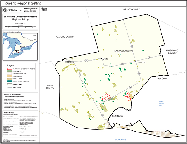
SWCR is one of the largest blocks of forest and natural habitat in the Carolinian Life Zone of southern Ontario (Figure 1). It is recognized regionally, provincially, and nationally for its exceptional biological diversity, natural heritage values and has potential for even greater value through restoration. The protected area’s combined diversity of ecological communities (including oak savanna, oak woodland, other tallgrass communities; and sand barrens, forests, wetlands and streams) supports one of the highest concentrations of species at risk in Ontario and Canada.
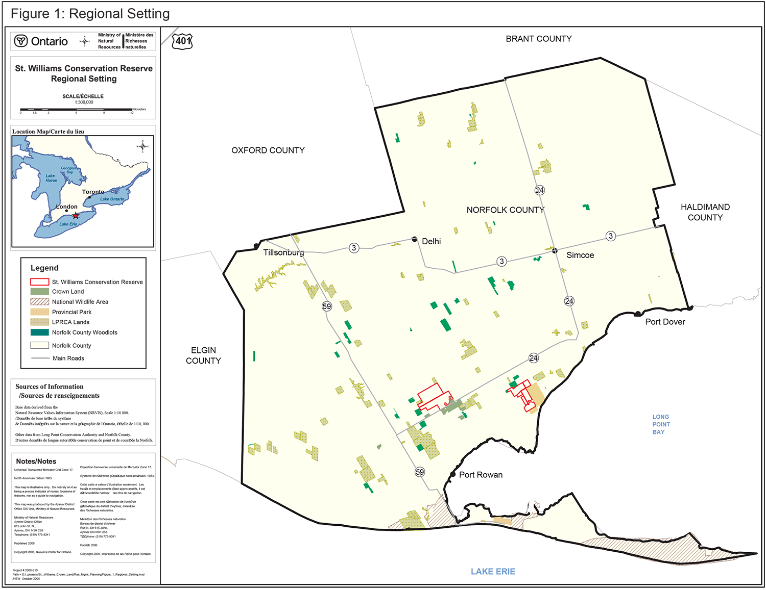
The conservation reserve is composed of two large but separate tracts of Crown land in Norfolk County that total 1033.95 hectares (Figure 2). These lands were part of Ontario’s first provincial forest station, which was in operation from 1908 to 1998. The tree seedlings produced at this forest station and its demonstration forests played a major role in the environmental conservation and soil stabilization efforts in southern Ontario in the twentieth century.
Ontario’s goal for SWCR is that these tracts will be a flourishing example of extraordinary biological diversity representing their pre-European settlement natural legacy of ecological communities while protecting their unique cultural heritage and providing opportunities for compatible public land uses.
Five key objectives for SWCR are:
Natural Heritage Protection and Restoration: Maintain and restore the native ecological communities (including oak savanna, oak woodland, other tallgrass communities; and sand barrens, forests, wetlands and streams) of SWCR, and their associated species and ecological processes.
Cultural Heritage Protection: Recognize the significance of SWCR as part of the first provincial forest station in Ontario. It also has potential for archaeological artifacts and sites.
Recreational Opportunities: Provide day use recreational opportunities and permit traditional public land uses that are compatible with natural heritage protection and restoration.
Educational Awareness: Raise awareness of the site’s significance, history, ecological processes, features, complexity, sensitivity and beauty.
Research Opportunities: Encourage research that helps guide the maintenance and restoration of the conservation reserve’s biological diversity using adaptive management.
This management plan defines the policies and strategies that will be used to guide management to achieve the goal and meet the stated objectives for SWCR.
1. Introduction
SWCR is located in Norfolk County in the geographic townships of South Walsingham and Charlotteville, 15 kilometers southwest of the Town of Simcoe (Figure 1). It is composed of 1033.95 hectares of Crown land that was formerly operated as part of the St. Williams Provincial Forest Station. The conservation reserve is managed by the MNR under provincial policy governing conservation reserves and the policy direction of this management plan.
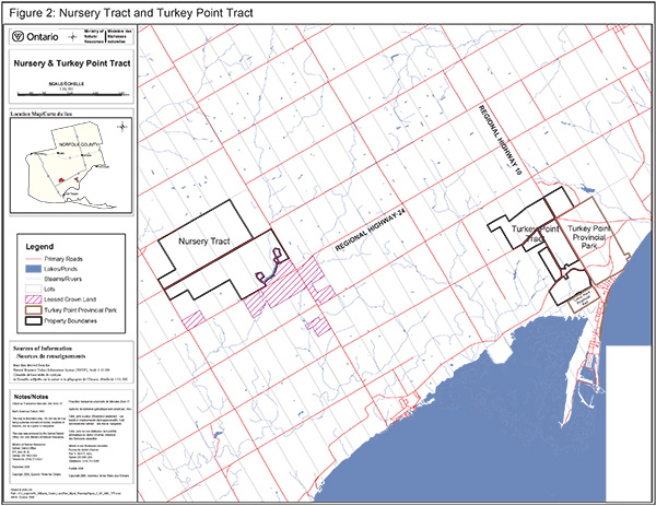
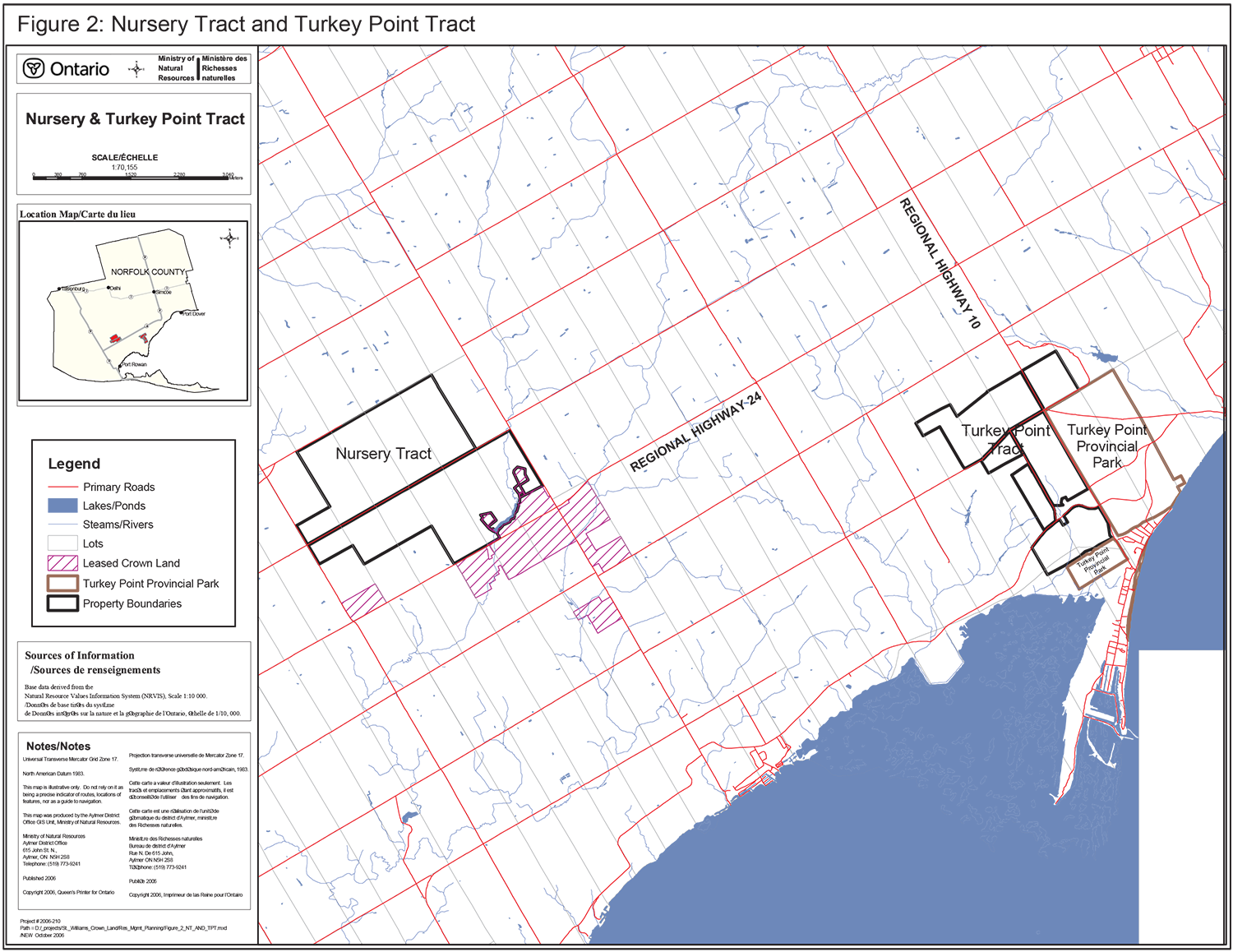
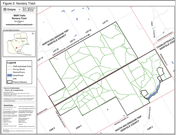
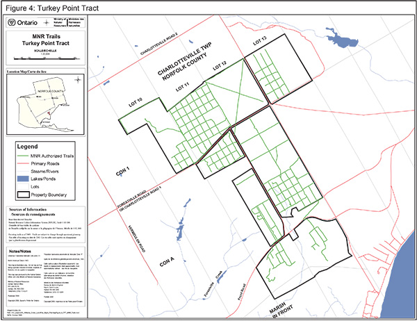
The conservation reserve includes two separate tracts of Crown land, the Nursery Tract (Figure 3) and the Turkey Point Tract (Figure 4). The latter is adjacent to Turkey Point Provincial Park. The conservation reserve is a core component of a larger complex of conservation lands within Norfolk County. Other publicly owned forest lands include the Norfolk County Forest Network, and properties owned and managed by the Long Point Region Conservation Authority. Coordination and cooperation of the management of these conservation lands will be sought with other agencies to improve greater regional ecosystem linkages and long term health.
The conservation reserve is on the Norfolk Sand Plain, deposited as a large delta in a glacial lake. Well formed sand dunes are prominent features on the Nursery Tract, but less frequent on the Turkey Point Tract. The dunes in SWCR are prone to wind erosion in the absence of vegetation cover and underlying root mat.
SWCR is one of the largest blocks of forest and other natural habitats in the Carolinian Life Zone of southern Ontario. It is recognized regionally, provincially, and nationally for its exceptional biological diversity, natural heritage values and has potential for even greater value through restoration. Its combined diversity of ecological communities (including oak savanna, oak woodland, other tallgrass communities; and sand barrens, forests, wetlands and streams) supports one of the highest concentrations of species at risk in Ontario and Canada. It is also internationally recognized as a natural heritage area within and adjacent to the Long Point World Biosphere Reserve, a United Nations Education, Scientific and Cultural Organization designation.
Prior to European settlement, the sandy lands in and around the conservation reserve supported large areas of oak savanna, tallgrass prairies and sand barrens, which have always been rare communities in Ontario. Conversion to agriculture in the late 1800s and early 1900s on predominantly drought-prone, sandy soils resulted in extensive wind erosion and sand blowouts.
Reforestation was proposed as one means of preventing further degradation of agricultural lands. The Ontario government purchased marginal farmland in Norfolk County and established the first provincial forest station in 1908. The forest station was established to: (1) provide tree seedling nursery stock for distribution throughout Ontario; (2) demonstrate the feasibility of reclaiming degraded lands by reforestation; and (3) experiment with various tree species in relation to this work. The St. Williams Provincial Forest Station operated from 1908 to 1998.
Figure 1: Regional Setting
Enlarge Figure 1: Regional Setting map
Figure 2: Boundary Map
Enlarge Figure 2: Boundary Map
Figure 3: Nursery Tract
Enlarge Figure 3: Nursery Tract map
Figure 4: Turkey Point Tract
Enlarge Figure 4: Turkey Point Tract map
The conservation reserve consists entirely of Crown land. Municipal roads and private land abut most of its boundaries but are not included as part of the conservation reserve. There are a few utility corridors and a natural gas well that predate the establishment of the conservation reserve.
As open access Crown land, SWCR has supported informal public recreation for many years, including hunting, bird-watching, nature appreciation, and various forms of trail use.
Most of the St. Williams Crown Lands were designated as a conservation reserve in the Simcoe DLUG in March, 2004. The conservation reserve has been recommended for regulation under the Public Lands Act (by amending Ontario Regulation 805/94) to protect this important natural heritage and public recreation area. Consistent with Ontario’s Biodiversity Strategy, the conservation reserve will be managed to provide for a natural succession of vegetation communities while also protecting species at risk from becoming locally extinct.
This management plan prescribes policy direction for a 50-year period (2005 – 2055) and replaces previous forest management plans or other policy documents that governed the use of the land to be regulated as SWCR.
There is one formal parking lot within the conservation reserve as well as some unauthorized parking lots that have been created by trail users. There are multiple unauthorized trails which continue to create issues and concerns and will be addressed through operational planning. A number of MNR access roads also exist within the conservation reserve.
All consultation with the public and Aboriginal groups is identified in Section 7 of this management plan.
2. Goal
Ontario’s goal for SWCR is that these tracts will be a flourishing example of extraordinary biological diversity representing their pre-European settlement natural legacy of ecological communities (including oak savanna, other tallgrass communities, sand barrens, Carolinian forests, wetlands and streams) while protecting their unique cultural heritage and providing opportunities for compatible public land uses.
3. Objectives
MNR has established conservation reserves for the purpose of protecting natural heritage in specific areas of public lands, while permitting traditional recreational public land uses that are compatible with natural heritage protection. A set of broad objectives were developed and measurable outcomes for each of these will be identified in an operational plan.
Objective 1: Natural heritage protection and restoration
Maintain and restore the native ecological communities (including oak savanna, oak woodland, other tallgrass communities; and sand barrens, forests, wetlands and streams) of SWCR, and their associated species and ecological processes.
SWCR is recognized as being provincially and nationally important for the conservation of biological diversity and natural heritage. It is a core component of a series of significant conservation lands located in Norfolk County. SWCR supports one of the largest remaining, although degraded, oak savannas in Canada, a globally threatened vegetation community. Natural heritage stewardship will include plans to restore oak savannas. Ninety species of provincially rare flora and fauna have been recorded within SWCR, plus many regional rarities. Some ecological communities within the conservation reserve will be managed to provide for natural succession while also protecting species at risk. The natural heritage values of SWCR will be protected through appropriate land management, restoration, education, and enforcement.
Objective 2: Cultural heritage protection
Recognize the cultural significance of SWCR as part of the first provincial forest station in Ontario.
The conservation reserve is part of the former St. Williams Provincial Forest Station, established in 1908, and has a rich history of reforestation. The tree seedlings produced at this forest station and its demonstration forests played a major role in the environmental conservation and soil stabilization efforts in southern Ontario in the twentieth century.
There is potential for archaeological artifacts and sites within SWCR.
The cultural heritage values of SWCR will be protected through appropriate land management, education, and enforcement.
Objective 3: Recreational opportunities
Provide day use recreational opportunities and permit traditional public land uses that are compatible with natural heritage protection and restoration.
The conservation reserve will offer opportunities for individuals, families, and small groups to experience this area. SWCR presents opportunities for traditional public land uses to continue within the goal of natural heritage protection. Non-mechanized activities like hiking, nature viewing, hunting, and fishing will be encouraged.
Traditional recreational activities that are compatible with natural heritage protection and restoration will be managed through appropriate natural heritage education, land management, and enforcement.
Objective 4: Educational awareness
Raise awareness of the site’s significance, history, ecological processes, features, complexity, sensitivity and beauty.
Learning about the significance of the conservation reserve’s natural and cultural heritage will be encouraged for both individuals and groups. The extraordinary biological diversity, restoration efforts and demonstration plantations provide excellent opportunities for education.
Objective 5: Research opportunities
Encourage research that helps guide the maintenance and restoration of the conservation reserve’s biological diversity using adaptive management (see section 4.1 below for definition).
SWCR has been an area of forest research since 1908, including growth and yield plots and provenance trials on a variety of tree species. Other scientific studies have included restoration techniques, carbon and water exchange in planted forests and breeding birds. Historical research projects will be evaluated and then continued or discontinued based on their relevance and compatibility.
New research that helps guide our understanding of the maintenance and restoration of the conservation reserve’s biological diversity and that is compatible with the management guidelines as defined in this plan will be encouraged subject to MNR approvals.
MNR's Class Environmental Assessment for Provincial Parks and Conservation Reserves came into effect on January 10, 2005. All new MNR projects in conservation reserves, new approvals or permits issued, and any relevant amendments must meet the legal requirements of this Class Environmental Assessment.
4. Resource stewardship policies
Species at risk, vegetation, wildlife, and cultural resource stewardship policies will be addressed through strategies in the operations plan. Adaptive management principles will be used for the protection and restoration of the natural heritage values of SWCR.
4.1. Inventory, monitoring and assessment
A life science inventory and evaluation of St. Williams Crown Forest was completed in 2002 and provides a significant amount of information and high quality analysis of the natural heritage values of SWCR. Additional inventories will be undertaken as necessary.
Adaptive management is a process for continually improving management policies and practices by learning from the evaluation of outcomes of operational programs. Monitoring to assess whether management techniques are achieving the stated objectives is an essential component to adaptive management. Where monitoring indicates techniques are not effective, adjustments will be made. There will be on-going monitoring of populations of species at risk.
4.2. Landforms
Forming part of the Norfolk Sand Plain, the soils within the conservation reserve are sandy and drought-prone, and consequently subject to erosion by wind and water. Vegetation cover will be managed to reduce erosion, where appropriate. Mining and the extraction of aggregates, peat, soils, petroleum (with the exception of the existing lease) and similar materials are prohibited within the conservation reserve.
4.3. Species at Risk
Populations of species at risk and their habitats will be monitored, protected and recovered. Direction provided by species and ecosystem recovery plans will be implemented through consultation with recovery teams and recognized specialists.
4.4. Vegetation
There are five main types of ecological communities in this conservation reserve (i.e., oak savanna, other tallgrass communities, sand barrens, Carolinian forests, wetlands and streams). Some of the communities will be managed by allowing natural ecosystems, processes and features to function normally. Other communities, including some conifer plantations, will have active management with appropriate disturbance regimes to restore natural systems.
Non-native species will not be deliberately introduced. Management approaches for the eradication or control of non-native species that threaten natural heritage values will be developed. Where feasible, native species formerly present in the general region of the conservation reserve may be re-established.
Populations of native insects and diseases affecting vegetation within the conservation reserve will normally be allowed to develop undisturbed. Non-native insects and diseases may be controlled if they threaten the values for which the conservation reserve was established, where feasible and necessary. Where control is undertaken, it will be directed as narrowly as possible to the specific insect or disease so as to have minimal effects on other components of the environment of the conservation reserve. The details regarding the prioritization and implementation of specific management activities to the control of invasive species will be provided in the operational plan.
Prescribed burns will be used to restore and maintain ecological communities, as appropriate, in accordance with the Fire Management Policy for Provincial Parks and Conservation Reserves (PL 3.03.09) and the Class Environmental Assessment for Provincial Parks and Conservation Reserves. All other fires will be suppressed, as needed. Fire response and suppression is provided by Norfolk County.
Wetland and Natural Forest
Wetland, riparian areas and the relatively undisturbed natural forest will generally be passively managed to maintain the area’s ecological health and function. Where feasible and appropriate, more active management techniques will be used to meet other objectives of this plan, e.g. ecological restoration, species at risk recovery.
Oak savanna and oak woodland
The life science inventory indicates that oak savanna and oak woodland were the dominant original ecological communities within this conservation reserve. Most of these vegetation communities were under-planted with coniferous trees while the site was managed as a provincial forest station. Oak savanna and oak woodland communities will be restored and maintained using appropriate management techniques. Management activities may include cutting, timber removal, mowing and prescribed burns. Merchantable material resulting from restoration activities may be salvaged, and any revenues earmarked and applied towards future ecosystem restoration or management activities.
Sand barrens
Sand barren communities will be maintained and restored through the management of disturbance levels such as prescribed burns, discing and cutting.
Conifer plantation
Some areas of the extensive conifer plantations will be retained to continue the demonstration of the environmental restoration and soil protection techniques of the twentieth century. As the plantations developed and matured, various forest management techniques were tested and demonstrated. Some of these plantations will be retained to provide opportunities for research, education, and demonstration. Other plantations will be managed for conversion to more natural vegetation communities. Plantations will be managed using appropriate silvicultural techniques, e.g. thinning, cutting, prescribed burning. Merchantable material resulting from conversion activities may be salvaged, and any revenues will be applied towards future ecosystem restoration or management activities.
4.5. Wildlife
Wildlife and fish will continue to be managed in accordance with provincial policies and regulations prevailing in the area. Recreational sport hunting will be allowed. Where feasible and appropriate, native species formerly present in the general region of the conservation reserve may be re-established.
Appropriate management techniques will be used to address threats to human health and safety presented by wildlife. Non-native species will not be deliberately introduced. Management approaches for the control of species that threaten natural heritage values will be developed where feasible and appropriate.
4.6. Cultural heritage
SWCR is a living record of the practices of ecological restoration dating back to 1908. The rich history of the conservation reserve will be protected by maintaining examples of the native conifer plantations. Interpretive material (e.g. publications, signage) will be developed to raise awareness of the history of SWCR. The privately operated St. Williams Museum located east of the conservation reserve on Highway 24 contains historic documents and equipment and may provide opportunities for collaborative efforts in education.
SWCR has potential for archaeological sites with artifacts ranging in age from the Archaic to historic periods. If archeological resources are discovered, appropriate steps will be taken in consultation with the Ministry of Culture to protect them. Should new structural development or significant clearing of vegetation or altering of land within this conservation reserve be considered, the cultural heritage resource screening process will be implemented as identified in the Memorandum of Understanding with the Ministry of Culture.
5. Operational policies
Alternatives to MNR staff undertaking all operational and management activities will be explored including alternative service delivery models and partnerships with other agencies. Management actions and operations undertaken by any partners of MNR must be consistent with the objectives and policies of this plan. Recreation, research, education and infrastructure policies will be addressed in greater detail in an operational plan, as required. Any proposed new uses will be reviewed within the framework of the approved management plan.
5.1. Recreation
Recreational activities that do not adversely affect the natural heritage and cultural values of the conservation reserve will be permitted.
5.1.1. Permitted activities
Walking, hiking, cross-country skiing, and wildlife viewing are not actively managed by MNR and will be allowed to continue. Fishing and hunting are regulated under provincial and federal legislation and are permitted according to provincial and federal policy and legislation.
Mountain biking and horseback riding is only permitted on authorized trails. The use of motorized vehicles under 300 kg is permitted on authorized trails only.
Recreational events authorized by MNR may be held in SWCR. Recreational activities and their impacts will be monitored. If a permitted recreational activity is found to have an adverse effect on the natural heritage values of SWCR, then the activity will be appropriately limited through an amendment to this plan and enforcement and mitigative measures.
5.1.2. Prohibited Activities
The use of motorized vehicles over 300 kg is prohibited with the exception of authorized maintenance vehicles. Unauthorized trails will be closed under the authority of appropriate legislation (e.g. Public Lands Act).
Overnight camping is prohibited. Open fires are prohibited. New private access roads are prohibited.
Collection of any flora or fauna or parts thereof is prohibited except where specifically authorized by MNR.
5.2. Research & education
Scientific research by qualified individuals, which contributes to the knowledge of natural and cultural history and to environmental and recreational management, will be encouraged. Research that causes negative impacts on the natural heritage values of the conservation reserve will not be permitted.
Due to the history of SWCR as a provincial forest station, several long-term research plots currently exist. All existing and proposed research programs will be reviewed on a case by case basis to determine if they complement the goal and objectives of this conservation reserve. They will require the approval of MNR and will be subject to Ministry policy and other appropriate legislation. Research proposals must follow appropriate procedural guidelines (e.g. C – Research Activities in Conservation Reserves (PL 3.03.05). The Ministry may approve the removal of any natural or cultural specimen by qualified researchers. All such materials will remain the property of MNR. Any site that is disturbed, other than for restoration purposes, will be appropriately rehabilitated.
5.3. Infrastructure
There are no existing facilities in the conservation reserve. Numerous municipal roads provide access through SWCR. The extensive system of existing trails and roads will be evaluated to determine if they are needed and if they are sited and aligned in an environmentally sensitive manner. Significant erosion, destruction of vegetation, and disruption of fauna have been observed on some trails. Portions of the existing trail system will be closed and/or abandoned due to the sensitivity of the site. Signage and barriers of natural or artificial materials will be used to prevent continued use.
A small network of trails will be maintained for multi-use and/or site maintenance and emergency access. Trails may be opened, closed, abandoned, or moved in accordance with the provision of recreational opportunities that do not adversely affect the protection of the natural heritage values of the conservation reserve.
The signage throughout the conservation reserve will be improved to clearly communicate permitted uses and boundaries.
There is one authorized parking lot in SWCR that may be improved. There are a few informal parking areas which may be authorized and improved, relocated, or closed. Construction to improve or create a new parking area is subject to the Class Environmental Assessment for Provincial Parks and Conservation Reserves and appropriate public consultation.
The conservation reserve includes a reservoir that was traditionally used for irrigation purposes in the production of tree nursery stock. MNR is responsible for the dam which creates the reservoir; the dam is outside the boundaries of SWCR.
New transmission lines, pipelines, and road corridors will be discouraged. Leasing or sale of parts or all of a conservation reserve is not permitted by MNR policy (PL 3.03.05).
New tourism developments will not be permitted. Major infrastructure will not be considered.
5.4. Enforcement
The enforcement program will be carried out in accordance with MNR policies and relevant legislation to provide for the safety of visitors and the protection of resources.
5.5. Land tenure and adjacent lands
Any unauthorized occupations of lands within the conservation reserve will be managed in accordance with approved policy and will be removed in a manner that causes the least disturbance to the site, at the occupier’s expense. In addition, enforcement action may be taken.
Through the Ministry’s municipal plan input and review program, applications for large-scale development on private lands adjacent to the conservation reserve will be reviewed to ensure natural heritage values within the conservation reserve are considered and protected in municipal planning decisions.
5.6. Commercial activities
Mining, commercial forest harvest, hydro-electric or wind power development, the extraction of aggregates, peat, soils, petroleum (with the exception of the existing lease) and similar materials, or other industrial purposes are prohibited by appropriate legislation, regulations and policies.
The removal of some standing timber is required to meet the management and restoration objectives of this plan. Merchantable material resulting from ecological restoration activities may be salvaged, and any revenues applied towards future restoration or management activities.
Commercial trapping and bait fishing will be permitted provided they do not negatively impact the natural heritage values of SWCR. The natural gas well and pipeline that was present before the establishment of the conservation reserve will be permitted to continue under the current lease. Current practices of this use will be reviewed to determine if any changes are required to sustain natural heritage features, functions and processes of the conservation reserve. Only commercial activities that do not negatively impact the natural heritage values of SWCR may be permitted.
6. Implementation priorities
In the implementation of the approved management plan, MNR will pursue opportunities for partnerships with other agencies and groups. Resource stewardship projects and operations will be contingent upon the availability of funding and will be subject to the legal requirements of MNR's Class Environmental Assessment for Provincial Parks and Conservation Reserves. Implementation of this management plan and operation of the conservation reserve will meet the requirements of the Environmental Assessment Act, Environmental Bill of Rights, Public Lands Act, Fish and Wildlife Conservation Act, and Endangered Species Act and other pertinent legislation.
Implementation priorities are as follows:
- Measurable outcomes for each of the stated objectives will be identified in operational plans
- Develop partnership arrangements for the implementation of priorities, e.g. restoration of oak savanna, education
- Develop a long term framework for the duration of this plan that provides implementation targets with corresponding timelines
- Develop and implement a ten-year operational plan that will include detailed implementation for each of the policies in this plan
- Initiate restoration of oak savanna / oak woodland as a recurring project
- Initiate conversions of conifer plantations to natural communities (i.e. oak savanna, other tallgrass communities, or Carolinian forest as appropriate) as a recurring project
- Rationalize and implement the authorized trail, road and parking system; improve, close or relocate trails, roads and parking areas as appropriate
- Initiate and continue monitoring the trail system for impact on vegetation and user compliance with permitted uses
- Improve methods, such as signage to better communicate permitted uses, education and boundaries
- Monitor conversion projects for regeneration of natural vegetation communities and habitat for species at risk
- Develop and implement the operational plan referenced in Sections 4 and 5 of this plan
- Develop educational tools such as interpretive signage or fact sheets
7. Summary of public and Aboriginal consultation
Public consultation was a very important part of the designation of the conservation reserve and the development of this management plan.
Public consultation regarding an alternative, community-focused delivery mechanism for the adequate protection and management of the St. Williams Crown Lands began in 1999. A steering committee was struck to lead the process. An initial public information session was held in 1999 and focus groups were developed. Meetings with the focus groups were held throughout 2000 and input was provided to the steering committee.
The recommendations of the steering committee were shared at a community information session in 2001. News releases and direct mailings were used to seek public input on the recommendations. A preferred model for the alternative service delivery was not selected as the comments received suggested that further protection for the St. Williams Crown Lands as a conservation reserve should be considered.
An eight-member Technical Advisory Group was created in 2002 to provide recommendations for the long-term management of the St. Williams Crown Lands. The group recommended that the native biological communities be maintained and restored, the conifer plantations be managed to return to natural forests, and that recreational activities that negatively impact the natural heritage values of the site be restricted or curtailed.
Two public open houses were held in June and December 2002 regarding the proposed land use designation of these Crown lands as a conservation reserve. A notice was posted on the Environmental Bill of Rights (EBR) Registry in May 2003 inviting written comments from the public regarding the designation of the lands as a conservation reserve. 158 comments were received and responded to in summary on the EBR Registry (No. PB03E3003). In June 2004, the Ministry’s decision to designate St. Williams as a conservation reserve was posted. Mailouts and newspaper advertisements coincided with the EBR postings.
A notice was posted on the EBR Registry (No. PB40E3001) to announce the beginning of the management planning process in June 2004. The public was invited to provide written comments. This notice was included in the direct mailout in June 2004 announcing the decision to designate St. Williams Crown Lands as a conservation reserve. Twelve written comments were received.
A draft of this management plan was posted on the EBR Registry for public inspection and written comments from the public were accepted between December 14, 2005 and February 13, 2006. The comments were given consideration through the development of this management plan and will be responded to in summary through a decision notice for the approved management plan on the EBR Registry. The decision to approve the SWCR management plan will be posted on the EBR Registry for a 45-day period.
Aboriginal and treaty rights, as identified under the Canadian Constitution, will be recognized and respected. The Six Nation First Nation Community was consulted throughout the management planning process, however no comments were received.
8. Reviews and revisions
The SWCR Management Plan in conjunction with the development of operational plans will be examined in ten years. The need for review of or amendment to the management direction will be determined. The results of this examination will be posted on the EBR Registry. However, if changes in management direction are needed, the significance of the changes will be evaluated. Administrative and minor amendments which do not alter the overall protection objectives may be considered at any time and approved by local MNR management without further public consultation and posting on the EBR Registry. Major amendments to this plan will only be considered with public consultation and will require the approval of the Regional Director.
Bibliography
Abrams, M.D. 1992. Fire and the development of oak forests. BioScience 42: 346-353.
Bakowsky, W., and J.L. Riley. 1992. A survey of the prairies and savannas of southern Ontario. In: Wickett, R.G., P.D. Lewis, A. Woodliffe and P. Pratt (eds.). 1992. Proceedings, Thirteenth North American Prairie Conference. Aug. 6-9, 1992. Windsor. 262 p.
Barnett, P.J. 1978. Quaternary Geology of the Simcoe Area, Southern Ontario. Geoscience Report 162. Ontario Ministry of Natural Resources. Toronto.
Barnett, P.J. 1982. Quaternary Geology of the Tillsonburg Area, Southern Ontario. Ontario Geological Survey Report 220. Ontario Ministry of Natural Resources. Toronto.
Barnett, P.J. 1998. Quaternary Geology Long Point - Port Burwell Area. Ontario Geological Survey Report 298. Queen’s Printer for Ontario.
British Columbia Forest Service. 2000. Definitions of Adaptive Management. http://www.for.gov.bc.ca/hfp/amhome/Amdefs.htm (Link no longer active)
Catling, P.M., V.R. Catling and S.M. McKay-Kuaja. 1992. The extent, floristic composition and maintenance of the Rice Lake Plains, based on historical records. Canadian Field Naturalist. 106(1): p. 73-86.
Chapman, L.J., and D.F. Putnam. 1984. The Physiography of Southern Ontario. Third Edition. Ontario Geological Survey, Special Volume 2. Ontario Ministry of Natural Resources. Government of Ontario. 270 p.
Coons, C.F. 1981. Reforestation on Private Lands in Ontario. Ontario Ministry of Natural Resources. February 1981. 31 p.
Department of Militia and Defence. 1909. Topographic Map, Ontario, Long Point Sheet. Scale 1:63,360. Surveyed 1904, Revised 1908.
Draper, W.B., M.E. Gartshore and J.M. Bowles. 2002. Life Science Inventory and Evaluation of St. Williams Crown Forest. Unpublished report by Bird Studies Canada, World Wildlife Fund and Tallgrass Ontario for Ontario Parks and the Ontario Ministry of Natural Resources. Vol. 1, 345 p. Vol 2, 705 p.
Fox, W.A. The Middle to Late Woodland Transition. In: Ellis, C.J. and N. Ferris (eds.). 1990. The Archaeology of Southern Ontario to A.D. 1650. Occasional Paper of the London Chapter, OAS Number 5. p 171-188.
Freemark, K.E., and H.G. Merriam. 1986. Importance of area and habitat heterogeneity to bird assemblages in temperate forest fragments. Biological Conservation 36 (1986) p 115-141.
Friesen, L., M.D. Cadman, P.J. Carson, K. Elliott, M.E. Gartshore, D. Martin, J.D. McCracken, P. Prevett, J. Oliver, B. Stutchbury, D.A. Sutherland and A. Woodliffe. 2000. National Recovery Plan for Acadian Flycatcher (Empidonax virescens), Hooded Warbler (Wilsonia citrina). National Recovery Plan No. 20. Recovery of Nationally Endangered Wildlife (RENEW). Ottawa, Ontario.
Gartshore, M.E. 1987. Annotated Checklist to the Mammals of Haldimand-Norfolk. In: M.E. Gartshore, D.A. Sutherland, J.D McCracken. 1987. The Natural Areas Inventory of the Regional Municipality of Haldimand-Norfolk, Norfolk Field Naturalists, Simcoe. Vol II.
Herms, C.P., D.G McCullough, L.S. Baue, R.A. Haack, D.L. Miller, and N.R. Dubois. 1997. Susceptibility of the endangered Karner Blue butterfly (Lepidoptera: Lycaenidae) to Bacillus thuringiensis var. kurstaki used for Gypsy Moth suppression in Michigan. The Great Lakes Entomologist 30: p 125 - 141.
Hills, G.A. 1959. A Ready Reference to the Description of the Land of Ontario and its Productivity. Ontario Department of Lands and Forests. Maple.
Jalava, J.V., P.J. Sorrill, J. Henson and K. Brodribb. 2000. The Big Picture Project: Developing A Natural Heritage Vision for Canada’s Southernmost Ecological Region. Science and Management of Protected Areas Association (SAMPA IV) Conference Proceedings. Manuscript submitted.
Kimmins, J.P. 1992. Balancing Act: Environmental Issues in Forestry. UBC Press, Vancouver. 244 p.
Lee, H., W. Bakowsky, J. Riley, J. Bowles, M. Puddister, P. Uhlig, and S. McMurray. 1998. Ecological Land Classification for Southern Ontario, First Approximation and Its Application. SCSS Field Guide FG-O2 September 1998. Ontario Ministry of Natural Resources, Southcentral Science Section, Science Development and Transfer Branch, North Bay, ON.
Moss, M.R., and P.L. Hosking. 1983. Forest Associations in Extreme Southern Ontario ca. 1817: a Bibliographical Analysis of Gourlay’s Statistical Account. Canadian Geographer XXVII: p 184-193.
Newmaster, S.G., A. Lehela, P.W.C. Uhlig, S. McMurray, M.J. Oldham. Ontario Plant List. Forest Research Paper No. 123. Ontario Forest Research Institute. Ontario Ministry of Natural Resources. Sault Ste. Marie, ON.
Ontario Department of Mines and Northern Affairs, 1972. Map 2226, Physiography of the South Central Portion of Southern Ontario. Scale: 1:253,440.
Ontario Ministry of Natural Resources. 2005. Ontario’s Biodiversity Strategy: Protecting what sustains us. 44 p.
Ontario Ministry of Natural Resources. 2004. A Class Environmental Assessment for Provincial Parks and Conservation Reserves. 134 p.
Ontario Ministry of Natural Resources. 2004. Fire Management Policy for Provincial Parks and Conservation Reserves. Ontario Parks/Aviation and Forest Fire Management/Lands and Waters Branches. Directive No. FM 2:12; PM 11.03.03; PL 3.03.09. 5 p.
Ontario Ministry of Natural Resources. 2000. A Silvicultural Guide to Managing Southern Ontario Forests. Ontario Ministry of Natural Resources. Queen’s Printer for Ontario, Toronto, Ontario. 648 p.
Ontario Ministry of Natural Resources. 1997. Conservation Reserves. Policy (8 p) and Procedure (22 p) PL 3.03.05. Lands and Natural Heritage Branch. February 11, 1997.
Ontario Ministry of Natural Resources. 1997. Unauthorized Occupations – Control and Removal. Policy (8 p.) and Procedure (12 p.) No. PL 3.03.02. Lands and Natural Heritage Branch. February 11, 1997.
Ontario Ministry of Natural Resources. 1991. Prescribed Burning. Policy No. FM 2:10. Aviation and Forest Fire Management Branch. Amended 1995. 2 p.
Packer, L., J. Grixti, H. Douglas, J. Janjic, R. Sellars, and M. Sommers. 2001. Insect Survey of Tall-Grass Prairie in Southern Ontario With Particular Reference to the Bees of the Manestar Tract. Unpublished report to Tallgrass Ontario, World Wildlife Fund under the Ontario Ministry of Natural Resources Ontario Living Legacy.
Presant, E.W., and C.J. Acton. 1984. The Soils of the Regional Municipality of Haldimand-Norfolk. Report No. 57 of the Ontario Institute of Pedology (Two Volumes). Land Resource Research Institute, Research Branch, Agriculture Canada. Guelph.
Puttock, G.D. 2001. Critical Review of Historical and Current Tree Planting Programs in Ontario. Ontario Ministry of Natural Resources. March 2001. 42 p.
Rodger, L. 1998. Tallgrass Communities of Southern Ontario, A Recovery Plan. Prepared by Lindsay Rodger for World Wildlife Fund Canada and the Ontario Ministry of Natural Resources. World Wildlife Fund, Toronto.
Rowe, J.S. 1972. Forest Regions of Canada. Canadian Forestry Service Publication No. 1300. Department of Fisheries and the Environment. Ministry of Supply and Services Canada, Ottawa, Ontario.
Technical Advisory Group (TAG): Dr. Duncan Sinclair, Dr. Jane Bowles, Michael Bradstreet, Robert Burgar, Steve Hounsell, Dr. Paul Prevett, Dr. David Puttock, and Elizabeth Snell. 2003. Recommendations for the Long-term Management of the St. Williams Crown Lands. St. Williams Crown Lands Technical Advisory Group. January 2003. 20 p.
Wallace, B., and J.D. McCracken. 1995. A Survey of the Breeding Birds of St. Williams Provincial Forest Station. Unpublished report prepared for Ontario Ministry of Natural Resources. Long Point Bird Observatory. Port Rowan.
Williamson, R.F. 1990. The Early Iroquoian Period of Southern Ontario. In: Ellis, C.J. and N. Ferris (eds.). 1990. The Archaeology of Southern Ontario to A.D. 1650. Occasional Paper of the London Chapter, OAS Number 5. p 291-320.
Zavitz, E.J. 1909. Report on the Restoration of Waste Lands in Southern Ontario. Published by the Ontario Department of Agriculture, Toronto. In: Zavitz, E.J. 1958. Fifty Years of Reforestation in Ontario. Ontario Department of Lands and Forests.