Stoco Fen Provincial Park Management Statement
This document provides policy direction for the protection, development and management of Stoco Fen Provincial Park and its resources.
1985 Government of Ontario
Ontario Ministry of Natural Resources
Hon. Alan W. Pope
Minister
John R. Sloan
Deputy Minister
Regional Director’s Approval Statement
January, 1985
I hereby approve this interim management statement for Stoco Fen. It will guide management of Crown Lands located in the fen until they are placed in regulation under the Provincial Parks Act and thereafter until a final management plan is prepared for the park. It will also direct any future land acquisition in the fen with which the Ministry of Natural Resources may be involved.
Signed by:
J. R. Oatway
Regional Director
Background
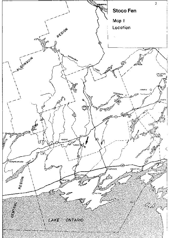
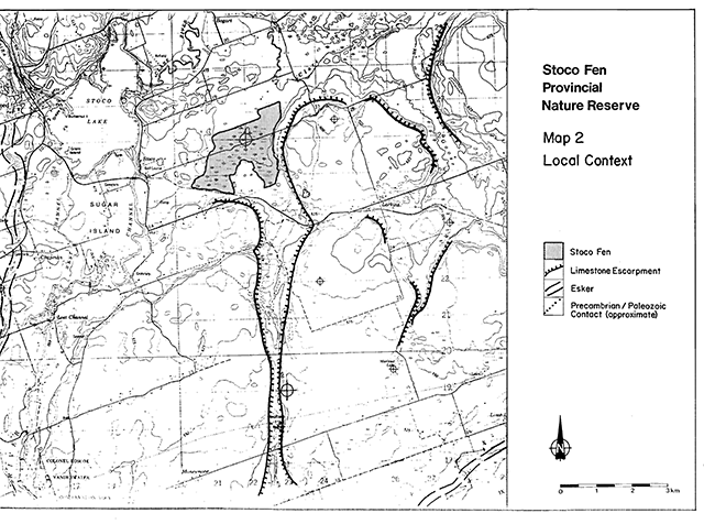
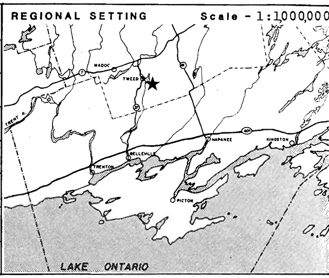
Stoco Fen is a wetland complex located 3 km east of Stoco Lake (6 km from the village of Tweed map 1). The wetland covers approximately 400 ha of a shallow depression between limestone plateaus at the head of a valley which served as a meltwater channel during early postglacial times (map 2). Drainage from the wetland is bidirectional, to the north into the Clare River and to the south into Coulters Creek. Water drains into the fen via surface runoff and subsurface flow from the surrounding limestone uplands. Thus the fen waters are rich in lime which, as shallow surface pools warm up, precipitates as marl. Much of the wetland is underlain by a mixture of marl and organic soil deposits.
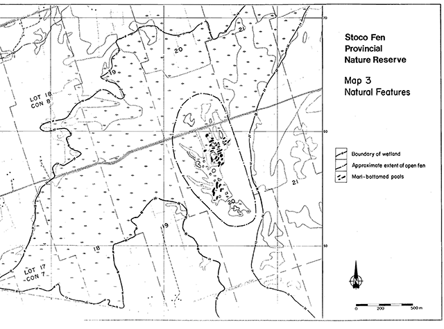
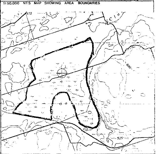
Most of the wetland vegetation consists of mixed swamp forest, with cedar swamp predominating. In the eastern part of the wetland, however, is an open fen complex covering about 50 ha (map 3). It consists of a mosaic of sedge meadows, shrub thickets, marl-bottomed pools and 'islands' of stunted cedar and larch trees. The fen has a high plant species diversity and provides habitat for a number of provincially and regionally rare plant species. Of greatest significance is a population of Small White Lady’s-slipper, an orchid which is endangered in Ontario. The Spotted Turtle, one of our rarest turtle species, also inhabits the fen. Other significant biological features are summarized in the appendices at the end of this document.
Much of the open fen area is publicly owned, partly by the Province of Ontario and partly by the Moira River Conservation Authority. In 1982, the Ministry of Natural Resources, after preliminary discussions with the Conservation Authority and after public consultation during land use planning open houses, decided to recommend that publicly owned portions of the fen be placed in regulation under the Provincial Parks Act as a Provincial Nature Reserve. This would protect the significant and sensitive features of the fen to a greater extent than is currently possible. The process of transferring title of a parcel of land owned by the Conservation Authority to the Province is currently underway. When the transfer is complete, regulation of the park can proceed.
This interim management statement has been prepared in response to a Ministry requirement for interim management guidelines for each candidate park. Interim management statements are intended to identify:
- park values to be protected
- the resource management prescriptions necessary to protect those values, and
- restrictions in use required to protect values
This statement is in conformity with the direction provided by the Tweed District Land use Guidelines, 1983 and will guide the Ministry’s activities in the Stoco Fen area until a formal management plan is prepared for the park.
Map 1 - Location
Map 2 - Local Context
Map 3 - Natural Features
Management statements
Land tenure
The land tenure of the proposed park and immediately adjacent area is shown on map 4. The area initially proposed for regulation (Lot 20, Con. VII, Hungerford Township) is owned half by the Province and half by the Moira River Conservation Authority. The part owned by the Conservation Authority is in the process of being transferred to the Province. Regulation of the park is not expected to occur until the transfer is complete.
The Conservation Authority owns another 40 ha of the wetland in which the fen is located (north half of Lot 18, Con. VII). With the exception of the township road allowance the balance of the wetland is privately owned.
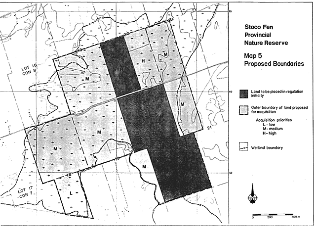
During the summer of 1984, a land owner approached the Ministry of Natural Resources and offered to sell a further 20 ha (50 acres) to the Province. This acquisition has been approved and is currently in progress. It is anticipated that this 20 ha will also be regulated as part of the park (see map 5).
From the perspective of protecting the most significant part of the wetland which is not already under public ownership (the open shrub/sedge fen in which the Small White Lady’s-slipper grows), control over activities along the township road and on the south half of Lot 20, Con. VIII, is most important. The Endangered Species Act provides legislated protection to the lady’s-slipper habitat but formal agreements should be sought with the respective landowners (see also the following section on land acquisition).
A Bell Canada telephone line is located on the township road allowance. The company has been notified of the significance of the site and requested to contact the District Manager of the Ministry of Natural Resources before doing any work in the area.
Other lands in and around the fen are of significance in adding to the diversity of the wetland, helping to maintain the water table of the fen and serving as recharge areas for the carbonate-rich groundwater which upwells in the fen and is essential to its existance. With respect to the latter, the upland limestone plains to the east of the fen are thought to be particularly important but hydrogeologic studies are required to determine the extent of this significance. The potential impact of land clearing and of housing and other development in this area is unknown at this time.
Guidelines:
- The ownership of all lands located within the wetland (as shown on map 4) will be ascertained.
- Land owners will be contacted and informed of the Ministry’s plans for a Provincial Nature Reserve in the fen area.
- Liaison with the Township of Hungerford will be maintained in order to prevent any adverse impacts on the fen which could be caused by road maintenance activities.
Map 4 - Land Ownership
Land Acquisition
Stoco Fen is part of a large wetland complex which extends north to the Clare River and south to Coulters Creek. The extent of the fen plant communities and of other significant wetland types has not been mapped in detail. The Nature Conservancy of Canada has expressed interest in participating in land acquisition in the Stoco Fen. For this purpose, a map showing land acquisition priorities for the fen was prepared in 1981. The acquisition priorities shown on map 5 essentially reproduce those of the earlier map. A minor modification has been made to exclude an area of agricultural land. The proposed boundary and acquisition priorities shown are subject to revision as more information about the fen becomes available.
Guideline:
Individuals, groups or agencies such as the Nature Conservancy of Canada will be encouraged to contribute towards land acquisition for conservation purposes. Direct land purchases, land exchanges or conservation easements acquired by the Ontario Government will depend upon the availability of funding. Land purchases will be made only from willing vendors.
Access
The township road along the front of the VIIIth Concession makes access to the heart of the fen extremely easy - too easy. The fen vegetation is very sensitive to trampling so access by the public should be discouraged. It is not anticipated that any access facilities will be required.
Fences around the proposed park area are either non-existent or in very poor condition. Cattle are or have been pastured to the southwest and northeast of the fen area but there is no evidence that they are gaining access to, or damaging the fen.
Guidelines:
- Use of the fen will be monitored and if adverse impacts are noted, the park will be posted and access will require the written permission of the Regional If necessary, assistance may be sought from the Township of Hungerford in having "no parking" or "no stopping" signs erected along the road.
- Fencing or other boundary markings are not recommended at this time, Should circumstances change and fencing (or surveying) be required, care will be taken to minimize environmental impacts.
Information services
To discourage use of the fen by the public, the park should be given a low profile in Ministry communications.
Guidelines:
- The park may be listed in general parks publications but will not be shown on detailed maps (including the Official Ontario Road Map).
- Unless it becomes necessary to restrict access to the park by posting it, signage will not be used to identify the park boundary.
- A modest brochure or information package will be prepared on the park to aid in answering public inquiries if it is determined that this will further the objectives of the park.
Scientific research
Over the past several years some of the most visible impacts to the open fen area have been caused by scientific and nature studies (sediment coring, plant collecting and general trampling of the vegetation).
Guideline:
In conformity with Ministry policy for Provincial Parks, all research activities will be strictly controlled through the issuance of research permits by the Regional Director. Applications for research will be approved only if the project meets the strict guidelines of the policy.
Vegetation management
Most of the rarer species in the Stoco Fen require relatively open, sunny habitats. Natural succession could eventually threaten these conditions in the fen. Succession in the fen is, however, a very slow process and active vegetation management is not expected to be required in the forseeable future.
Guidelines:
- Vegetation management will not be undertaken until a vegetation management plan has been prepared for the
- A vegetation management plan will be prepared after the natural resources of the wetland have been more fully documented (see the resource inventories section on the following page).
Wildlife Management
Some of the more notable wildlife species of the fen include the Spotted Turtle and the Black Bear. No active wildlife management is anticipated but further inventory of wildlife resources is required.
Guideline:
The subject of wildlife management and the need for a wildlife management plan will be addressed in the final Park Management Plan after additional inventory work has been completed.
Resource inventories
To date, detailed resource inventory work has been concentrated in the vicinity of the open fen area (Lot 20, Con. VII and VIII). The natural resources have not been examined or evaluated in detail for the remainder of the wetland. Information on the rest of the wetland is necessary to determine if, and how much, further land acquisition is prudent. It is also required before management plan(s) for the wetland can be formulated.
Further geological/geomorphological/hydrological studies of the general fen area are required to determine the sources of the calcareous fen waters and the overall significance of the geological features in the vicinity of the fen.
Guidelines:
- A detailed life science inventory of the Stoco Fen wetland complex will be undertaken before a final management plan is prepared for the park.
- A hydrogeologic study will be undertaken to determine the source, characteristics and sensitivity of fen waters.
Zoning
The sensitive and highly significant open fen area requires the maximum protection available within the existing management policies of the Provincial Park system.
Guideline:
The entire land area initially placed in regulation will designated as a nature reserve zone. Any additional lands acquired will also be managed as nature reserve zones, at least until a final management plan is prepared for the park.
Map 5 - Proposed Boundaries
Selected bibliography
Argus, G.W. and D.J. White, 1977. The Rare vascular Plants of Ontario. Botany Division, National Museum of Natural Sciences, Ottawa.
Argus, G.W. and D.J. White, 1982. Atlas of the Rare vascular Plants of Ontario. Botany Division, National Museum of Natural Sciences, Ottawa.
Brownell, V.R., 1981. The Small White Lady’s-slipper (cypripedium candidum Muhl. ex. Willd.) in Canada: A Status Report. Prepared for the Ontario Ministry of Natural Resources, Wildlife Branch, Toronto.
Catling, P.M. and R.E. Whiting, 1976. Orchids fragile and endangered. Ontario Naturalist 16(3):20-30.
Cuddy, D.G., 1981. Stoco Fen- Life Science Inventory Check-sheet. Ontario Ministry of Natural Resources, Kemptville.
Luciuk, L.Y., P. Ward and A. Forsyth, 1974. stoco Lake Bog – Sensitive Areas and Features Report. Ontario Ministry of Natural Resources, Tweed.
Ontario, 1980. Endangered Species Act. Revised Statutes of Ontario, Chapter 138.
Ontario Ministry of Natural Resources, 1982. Background Information on Land Use Planning and Park Systen Planning in Ontario.
Ontario Ministry of Natural Resources, 1983. Tweed District Land use Guidelines.
Reddoch, J.M., 1979. Same Eastern Ontario Bogs and Fens. The Ottawa Field-Naturalist’s Club, unpublished mimeo.
Background Summary
| Name: | Stoco Fen |
|---|---|
| Proposed Class: | Nature Reserve |
| M.N.R. District: | Tweed |
| M.N.R. Region: | Eastern |
| Area (ha.): | 81 |
| Site Region: | 6 |
| Site District: | 9 |
| Date in Regulation: | 1984 (proposed |
Regional Setting Map
Targets
Life science representation
| Site type/landscape unit | Species/communities |
|---|---|
| Organic & marl (clay) soils. Wet to saturated. Normal to cooler than normal. |
Sedge/shrub marl fen; cedar swamp. Cyeripedium candidum, Eleocharis rosttellata, Valeriana uliginosa, clemmys guttata |
Earth science representation
| Geological theme | Feature |
|---|---|
| N/A | N/A |
Recreation opportunities
| Day use | Car camping | Wilderness back country |
|---|---|---|
| N/A | N/A | N/A |
Inventories
| Level type | Earth science | Life science | Cultural | recreational |
|---|---|---|---|---|
| Reconnaissance completed | Yes | Yes | No | No |
| Detailed completed | No | No | No | No |
| Required | Yes | Yes | No | No |
Ontario Nature Reserves program – Life science inventory check-sheet
| Name: | Map name: | Map number: | UTM Ref. |
|---|---|---|---|
| Stoco Fen | Tweed | 31C/6 | 220260 |
| County, District or Regional Municipality | Hastings County |
|---|---|
| Lat. | 44° 28'N |
| Long. | 77°14'W |
| ALT. | ca. |
| MIN. | 470 ft. |
| MAX | 500 ft. |
| Locality | 3 km east of Stoco Lake |
| Township | Hungerford Hungerford |
| Lots | pt. 18-22 pt. 18-21 |
| Concessions | VII VIII |
| Area | 1000 |
| Acres | 400 ha |
| Ownership | Private/Crown/C.A. |
| Administration | Private/Crown |
| Forest region and district | L-1 |
| Site region and district | 6-9 |
| MNR region and district | E - Tweed |
| Conservation Authority | Moira |
| Base map | 444771 |
Aerial photographs
| Year | Roll | Flight line | Numbers |
|---|---|---|---|
| 1978 | 138 | 4432 | 241-245 |
| 1978 | 139 | 4433 | 147-149 |
Map boundaries
Physical and biological features
Stoco fen is a large calcareous fen underlain by marl and organic deposits. The fen shows considerable diversity in physiography and vegetation with extensive cedar - larch - spruce swamp forest, shrub bog/fen and sedge fen communities. The soil pH varies between highly calcareous pools and sloughs and acidic hummocks. Of interest is an abundance of Skunk Cabbage in the swamp forest and shrub thickets. Overall there is a high species diversity.
Several rare species occur: Ram’s-head Lady’s-slipper, Small White Lady’s-slipper, Eleocharis rostellata, Valerian, False Asphodel and Spotted Turtle.
Data sheets attached
| Physical description | X |
|---|---|
| Vegetation summary | X |
| Evaluation sheet | X |
| Community descrs. | |
| Community comp. lists | |
| Summary species lits | X |
| Physical features map | |
| Vegetation map | |
| Bibliography | X |
| Photographs | X |
| Major information sources | Luciuk, Ward and forsyth, 1974. Cuddy, 1977, 1978, 1980. Catling, et al. 1976. Reddoch, 1979. |
Evaluation and priorities
Highly significant fen complex. Excellent candidate for a Provincial Nature Reserve
Physical description
Bedrock
The fen area is surrounded by shallowly-soiled limestone bedrock.
Physiography
The fen lies in a shallow basin in relatively flat-lying limestone bedrock. Hummocks in the fen provide acidic growing conditions in close proximity to alkaline sloughs.
Soils
The fen is underlain by a complex of peat and marl substrates which are often
interlayeied.
Groundwater
The carbonate content of surface waters suggests at least partial phreatic origin.
Surface water
The fen is largely flooded during the spring but dries up most summers except for the stream which runs through it. The surface waters are carbonate rich.
Shores
nil
Climate
Normal? The location of the fen in a depression may cause greater than norm~l temperature extremes.
Disturbance history
A gravel township road crosses the fen. Parallelling it is a local telephone line. Part of lot 21, Con. VIII has been clear-cut (cedar posts).
Vegetation summary
| Number | Association or complex | Area (ha) | Soil texture | Moisture regime | Micro-climate | Soil pH | Data sheet |
|---|---|---|---|---|---|---|---|
| 1 | Cedar -Larch -Black Spruce swampforest | ||||||
| 2 | Shrub fen/bog complex | ||||||
| 3 | Sedge fen | ||||||
| 4 | Open Marl flats | ||||||
| 5 | Tall sedge-grass fen |
Evaluation
Outstanding associations
- sedge-forb-shrub fen
- rich cedar swamp forest
Significant species or features
Flora
Plants rare in Ontario
- Cypripedium candidum
footnote * - Cypripedium arietinum
- Valeriana uliginosa
- Eleocharis rostellata
Plants rare in Eastern Ontario
- Tofieldia glutinosa
Fauna
Locally Rare or Uncommon
- Spotted Turtle
- Black Bear
Potential disturbances and threats
- drainage
- logging of cedar swamp
- trampling, extensive plant collecting
- road, utility line maintenance activities
Brief summary
A floristically rich marl fen with a diversity of open and forested habitats. veral provincially rare plant species occur. Cypripedium candidum is on the province’s Endangered Species list.
Recommendations
- High priority area for protection. The entire fen should be acquired and given protective (Nature Reserve) status.
- Consideration should be given to closing the Township road whichpasses through the fen, thereby limited access to the most sensitive part of the fen (where Cypripedium candidum grows).