Temagami River Provincial Park Management Statement
This document provides policy direction for the protection, development and management of Temagami River Provincial Park and its resources.
Interim Management Statement
2006
Approval statement
I am pleased to approve this Interim Management Statement for Temagami River Provincial Park. Ontario’s Living Legacy Land Use Strategy (OMNR 1999) has identified this area as a waterway class provincial park. This provincial park was regulated under the Provincial Parks Act in 2000 (O. Reg. 685/00).
This Interim Management Statement provides direction for the protection and custodial management of Temagami River Provincial Park.
Paul Bewick
Zone Manager
Northeast Zone
Ontario Parks
Date: November 10, 2006
1.0 Introduction
Temagami River Provincial Park was regulated on December 21, 2000 (O. Reg. 685/00). This provincial park was identified through Ontario’s Living Legacy and is classified as a waterway park. The purpose of the waterway designation within the context of the provincial park system is to protect outstanding recreational water routes and to provide high quality recreational and educational opportunities.
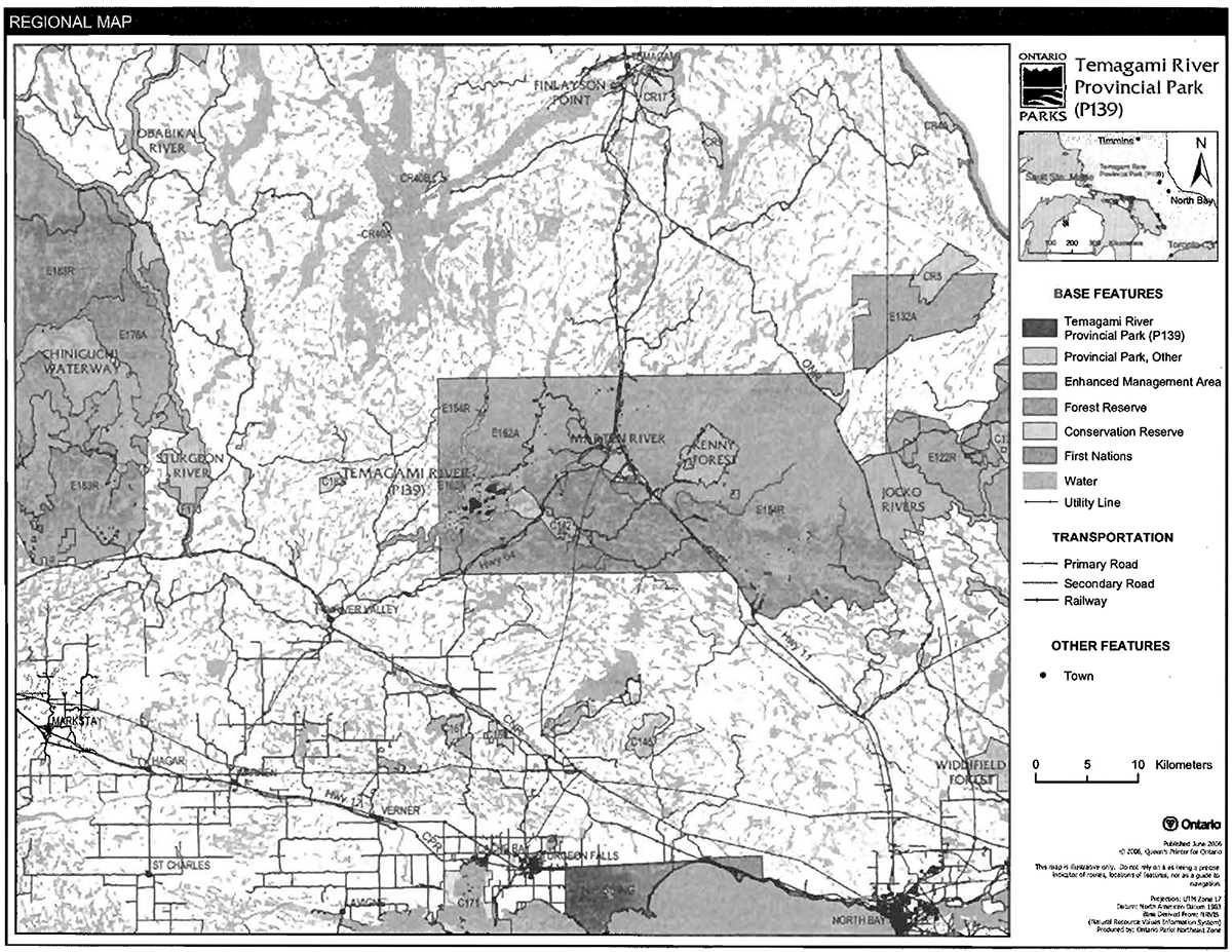
Temagami River Provincial Park is located approximately 40 kilometres north-east of Sudbury and 60 kilometres north of North Bay (Figure 1). The regulated boundary includes lands and waters in McCallum, McWilliams, and Thistle Townships in the District of Nipissing (Figure 2). This waterway provincial park encompasses 3,394 hectares.
1.1 Objectives
Temagami River Provincial Park will be managed according to provincial park objectives:
Protection: To protect provincially significant elements of the natural and cultural landscapes of Ontario.
Recreation: To provide provincial park outdoor recreation opportunities ranging from highintensity day-use to low-intensity wilderness experiences.
Heritage Appreciation: To provide opportunities for exploration and appreciation of the outdoor natural and cultural heritage of Ontario.
Tourism: To provide Ontario’s residents and out-of-province visitors with opportunities to discover and experience the distinctive regions of the Province.
2.0 Management context
The purpose of this Interim Management Statement (IMS) is to provide direction to ensure the custodial management of park resources. Future park planning may be undertaken as required to provide direction on significant decisions regarding resource stewardship, development, operations and permitted uses.
Park management will follow direction from:
- Provincial Parks Act (1990) and regulations;
- Ontario Provincial Parks Planning and Management Policies (OMNR 1992);
- Ontario Crown Land Use Policy Atlas (OMNR 2004a); and
- Ontario’s Living Legacy Land Use Strategy (OMNR 1999) and policy clarification amendments (OMNR 2000a) and related
In addressing custodial management obligations to protect park values and ensure public health and safety, Ontario Parks will ensure that policy and Environmental Assessment Act (1990) requirements are implemented.
Figure 1: Regional setting
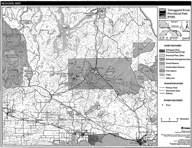
Enlarge figure 1 regional settings map
Figure 2: Park boundary
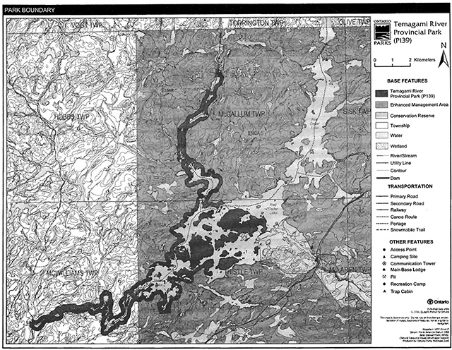
Enlarge figure 2 park boundary map
2.1 Environmental assessment
As part of the Ontario Ministry of Natural Resources (MNR), Ontario Parks is a public sector agency that is subject to the Environmental Assessment Act. Park management will be carried out in accordance with legislation, policies and guidelines that are required under MNR's A Class Environmental Assessment for Provincial Parks and Conservation Reserves (OMNR 2005a).
3.0 Park features and values
The Temagami River is one of several large to small rivers draining the southern Precambrian Shield in Ecodistrict 4E-4. The drainage is part of the Lake Huron basin. This 30 kilometre long waterway is known for its concentration of novice to advanced white water paddling opportunities. Part of Red Cedar Lake and all of Thistle Lake, also known as Island Lake, are within the park.
3.1 Geological features
Temagami River Provincial Park is in the north-eastern part of the Grenville Front Tectonic Zone of the Ontario Central Gneiss Belt, in the north-western part of the Grenville Province. The Grenville Province is the product of the movement and collision of the Earth’s crust approximately 1,140 to 1,170 million years ago. The main bedrock types of Temagami River Provincial Park include gneissic coarse metasediments and migmatitic and gneissic granitic intrusive rocks (Frey and Duba 2002).
The surficial deposits of Temagami River Provincial Park are Late Wisconsinan in age. The small areas of bedrock uplands along the shoreline of the Temagami River have a discontinuous till cover of thin sandy-silty ground moraine (Frey and Duba 2002).
The bedrock geology of Temagami River Provincial Park is provincially significant in its representation of part of the Grenville Front Tectonic Zone.
3.2 Biological features
Temagami River Provincial Park is located in Ecodistricts 4E-4 and 5E-6.
The upper portions of the river are typically flanked by white cedar and yellow birch near the shore, and mature or old pine - mixed hardwood communities on the valley slopes. Old pine communities, as well as black ash swamps, mixed hardwood uplands, and tolerant hardwood uplands are found in the Red Cedar and Island lakes area. The lower section of the Temagami River includes mixed pine communities on the north shore, and pine - hardwood forests on the south shore. Black ash swamps and open wetlands are also present in the lower section (Morris 2001).
Major ecosites of Temagami River Provincial Park include white pine mixed woods, red maple red oak uplands, sugar maple forests, intolerant hardwood forests, moderately-rich coniferous forests, and rich coniferous forest. Regionally significant representation includes rich lacustrine aquatic marshes and riverine sedge marshes (Morris 2001).
3.3 Cultural setting
Temagami has a rich cultural heritage; local native people and others have recorded this heritage from various perspectives (Speck 1915, Hodgins 1989, Wilson 2004).
The Temagami area is the homeland of the Teme-Augama Anishnabai (the Deep Water) people for at least the last 5,000 years. The Temagami River is within the 4,000 square-mile area that is referred to as n'Daki Menan ("Our Land"). The waters of n'Daki Menan are considered to be one of the world’s largest recorded network of nastawgan (traditional Aboriginal trails), largely intact and up to 3,000 years old, and one of the greatest concentrations of archaeological sites on the Canadian Shield.
An investigation into the cultural features specific to Temagami River ProvincialPark has not been completed at this time. Any future planning will be within the context of a provincial framework, A Topical Organization of Ontario History (OMNR 1974). In addition, updates and discussions with First Nations, other agencies and stakeholders may be carried out to identify cultural heritage values and features within the park and their significance. This information may be used to develop management guidelines to conserve and protect representative archaeological and historical values and features, or to provide direction for further research.
3.4 Recreation
The Temagami River has a reputation as an accessible white water river with numerous swifts, chutes, and rapids (Kershaw 2002, Wilson 2004).
The Temagami River. was identified as providing a 'natural river' experience on portions of the waterway within the park. Cross, Red Cedar and Thistle lakes as well as the Temagami River below the park, could be classed as providing 'modified river' experiences (Kershaw 2002).
A variety of recreational pursuits occur along the river. These include land based and water based activities: canoeing, kayaking, cottaging, motor boating, fishing, camping, hunting, landscape viewing, and wildlife viewing (Kershaw 2002).
4.0 Aboriginal uses
Temagami River Provincial Park lies within the Robinson-Huron Treaty (1850} area and just north of the Nipissing Indian Reserve.
Discussions regarding the regulation of Temagami River ProvincialPark occurred with the Dokis First Nation, Nipissing First Nation, Temagami First Nation, Teme Augama Anishnabai and Mattawa/North Bay Algonquins (OMNR 2000b).
First Nations have expressed interest in and have shared knowledge of the park and surrounding area. Aboriginal communities have used the area for hunting, trapping, fishing, gathering and travel. These uses may continue, subject to public safety, conservation and other considerations.
Any communications and cooperation between Aboriginal communities and MNR for planning and operations purposes will be done without prejudice to any future discussions or negotiations between the government of Ontario and Aboriginal communities.
5.0 Stewardship policies
The removal, damage or defacing of Crown property, natural objects, relics and artefacts is not permitted in provincial parks (Provincial Parks Act).
5.1 Terrestrial ecosystems
5.1.1 Vegetation
Harvesting
Commercial forest operations are not permitted within the park (OMNR 2004a).
The harvest of non-timber forest products such as club moss, Canada yew etc. will not be permitted within the park.
Existing authorized wild rice harvesting may continue. New operations will not be permitted. There are no fuelwood cutting permits currently issued for the park. No new permits will be issued (OMNR 2000a).
Non-native plants
Non-native plant species will not deliberately be introduced into Temagami River Provincial Park. Where non-native plant species are already established and threaten park values. a strategy to control non-native plant species may be developed (OMNR 1992).
Insects and disease
Insects and diseases may be managed where the aesthetic, cultural or natural values of the park are threatened (OMNR 1992). Control measures will follow guidelines established by the Ontario Ministry of the Environment (MOE) and MNR. Whenever possible, biological controls will be given preference over the use of chemicals (OMNR 1992).
Fire
In accordance with existing provincial park policy and the Forest Fire Management Strategy for Ontario, forest fire protection will be carried out in the park as on surrounding lands (OMNR 2004a).
Whenever feasible, MNR's Forest Fire Management program will use techniques which minimize damage to the landscape, such as limiting the use of heavy equipment or limiting the number of trees felled during response efforts (OMNR 2004b).
5.1.2 Wildlife management
Temagami River Provincial Park is located within Wildlife Management Units 40 and 41. The removal or harassment of non-game animals is not permitted in provincial parks (Provincial Parks Act).
Hunting
Sport hunting is permitted to continue. Considerations of safety and conservation with respect to hunting may be made through future management planning, which will include public and Aboriginal consultation (OMNR 2000a).
The Fish and Wildlife Conservation Act (1999) and the Migratory Birds Convention Act (1994) govern hunting within the park. The Ontario Hunting Regulations Summary contains regulations specific to this area. The harvest of bullfrogs or snapping turtles is illegal in provincial parks.
Bear management areas
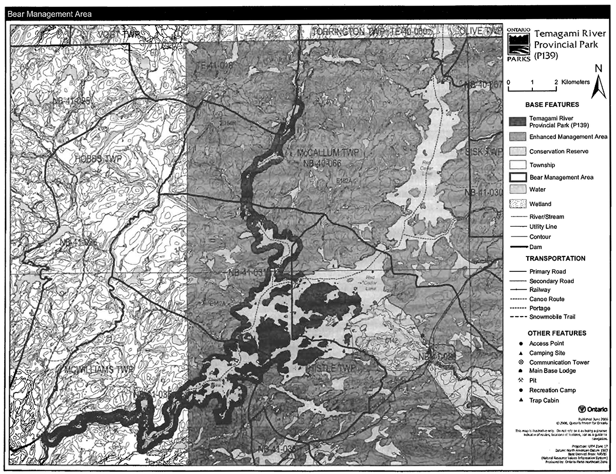
Temagami River Provincial Park includes portions of five bear management areas (BMA): NB41-028, NB41-035, NB41-031, NB40-066, and TE41-018 (Figure 3).
Existing commercial bear hunting operations are permitted to continue. This activity may be subject to conditions identified during future management planning (e.g. potential designation of nature reserve zones).
New BMA licences will not be permitted (OMNR 2000a; 2003).
Figure 3: Bear management areas

Enlarge figure 3 bear management area map
Trapping
There are portions of six trap lines included in the area of Temagami River Provincial Park: NB-13, NB-07, NB-06, NB-08, 1-27 and 1-28 (Figure 4). There are currently three trap cabins located within the boundary of the park (NB-06, NB-07, and NB-13).
Existing commercial fur harvesting operations may continue where the activity has been licensed or permitted since January 1, 1992. New operations, including trap cabins and trails, will not be permitted (OMNR 2000a; 2003).
Transfers of active trap line licenses are permitted, subject to a review of potential impacts and the normal transfer or renewal conditions that apply
Figure 4: Trap line areas
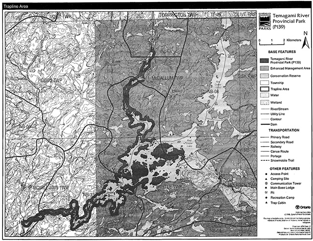
Enlarge figure 4 trap line areas map
5.1.3 Industrial resources
There are no licensed aggregate pits (active or inactive) located within the boundary of Temagami River Provincial Park. Aggregate extraction is not permitted in provincial parks (OMNR 1992, 2004a).
There are no existing mining claims within the park. Mining and surface rights on all lands within the park have been withdrawn from staking under the Mining Act (1990). Mineral exploration and mineral extraction are not permitted in provincial parks (OMNR 1992). In accordance with Ontario’s Living Legacy Land Use Strategy (OMNR 1999}, however, access through the park to mining lands for purposes of mineral exploration, development or operations (i.e. forest reserves and mining patents) will be permitted. Access will be planned in accordance with the requirements of the Environmental Assessment Act.
5.1.4 Access and crossings
Access
Temagami River Provincial Park can be reached by water, air and land.
Aircraft are able to land on Cross Lake, Red Cedar Lake, and Thistle (Island) Lake.
There are boat launch sites at access points that provide access to this park: at the west end of the park from Baie Jeanne Road and a launch near Island Lake Camp.
There are several points which provide indirect water access to this park. The Temagami River Camp on Red Cedar Lake, Mountain View Camp on Holdridge Creek, Red Cedar Lake Camp, and the Ministry of Transportation (MTO) area on Highway 64 provide indirect water access to Temagami River Provincial Park.
Roads
Island Lake Road travels from Highway 64 to Thistle (Island) Lake. There is an extension of this road that travels to the southern part of Red Cedar Lake. This road is usually used by camp owners {Island Lake Camp), hunters, anglers, and canoeists (Kershaw 2002).
The Baie Jeanne Road, a road used by forest companies, crosses over (bridge crossing) the Temagami River, near the most western limit of the park. The corridor and bridge crossing are not included within the boundary of the park.
There is an old forest access road that branches off Cross Lake Road and travels to the west side of the Temagami River, near the northern limit of the park. A bridge that crossed over at this point has been removed.
There are also some operational forestry roads that cross into the boundary of the park to the south of the Temagami River and Thistle Lake.
Where existing forest access roads are essential for continued access within or beyond the park for forest management, recreation or in-holding purposes, and alternative road access does not exist, or road relocation is not feasible, existing roads will continue to be available for access. Continued use will include maintenance and may include upgrade (OMNR 2004a). Ontario Parks is not responsible for the maintenance or upgrade of any roads within the park boundary.
Any proposed development, maintenance or upgrading of existing roads must meet all Environmental Assessment Act requirements.
Crossing of waterway parks by new roads may be necessary. The number of crossings will be minimized where possible and they will be managed to reduce their impact on recreational and aesthetic values. Any future road crossings proposed through the park, where park lands are unavoidable, will be reviewed on a case-by-case basis. Protection of park values will be priority and all requirements of the Environmental Assessment Act will be met.
Aggregate resource extraction is not permitted within parks. An external source of aggregate is required for road improvements and maintenance.
Utility corridors
There are no utility corridors which cross the boundary of the park. All public utilities (e.g., gas pipelines, transmission lines, communications towers, etc.) must avoid park lands wherever possible; however, new utility corridor crossings may be necessary to maintain essential public services (OMNR 2004a).
New crossings will be minimized where possible and they will be managed to reduce their impact on recreational, biological, cultural, geological and aesthetic values (OMNR 2004a).
Any future utility corridors proposed through the park, where park lands are unavoidable, will be reviewed on a case-by-case basis. Protection of park values will be a priority and Environmental Assessment Act requirements must be met.
Railway
There are no crossings of the park boundary by railway corridors.
Recreational trails
All-Terrain Vehicles: There is one all-terrain vehicle (ATV) trail from Island Lake Camp to the Red Cedar Lake South Control Dam. This trail, which is authorized by MNR, is used regularly by Ontario Power Generation to manipulate the dam. The trail is gated and public motorized use is not permitted.
An unauthorized ATV trail is located along the southern shore of the Temagami River. This trail . travels from Baie Jeanne Road to Island Portage.
Canoe Routes: The Temagami River is a known canoe route (Wilson 2004). The entire length of the canoe route along the Temagami River is 64 kilometres; 30 of which are included in this provincial park. The canoe route has approximately 20 sets of rapids (14 within the park) ranging in levels of difficulty. Portages occur at each rapid.
Hiking: There are no designated hiking trails in Temagami River Provincial Park at this time.
Snowmobiles: There are no authorized snowmobile trails within the park.
New trails (e.g., hiking) may be developed if the need can be justified through planning. Any proposed development within the park is subject to Environmental Assessment Act requirements.
5.1.5 Adjacent land management
Forestry
The land adjacent to the park is located within the Nipissing Forest Management Unit (FMU 754). This FMU is currently managed by sustainable forest licensee Nipissing Forest Resources Management Incorporated and is scheduled for renewal in 2009 (OMNR 2005b).
Enhanced management areas
The upper two thirds of this park are surrounded by two Enhanced Management Areas (EMA): Marten River (E154r) and McCallum Peninsula/Thistle Township (E162a).
Marten River EMA (E154r) is 5,883 hectares in size. This EMA is important to tourism, recreational, and resource sectors. Resource extraction activities can be considered in the context of future semi-remote access planning to protect semi-remote tourism values and important recreation areas (OMNR 2004a).
McCallum Peninsula/Thistle Township (E162a) EMA is 33,881 hectares in size. This EMA is made up of geographically separated areas managed as limited access areas. The management objective will be to maintain the remote character of the area. Providing existing road access is not enhanced, traditional recreational and resource uses (e.g. forest management) are permitted (OMNR 2004a).
Conservation reserves
The Holdridge Creek Conservation Reserve (CR) is contiguous with the eastern side of the park. This CR (C142) is a 1,343 hectare area that is covered by a large and extensive network of wetland habitats, including marshes and swamps, bordered by rock outcrops (OMNR 1999). The land use intent of this area is to protect the extensive marsh community, the unique site type representation of red oak and white pine on rock outcrop, and the Holdridge Creek riparian wetland which performs important hydrological functions including water quality improvement and shoreline erosion control.
Shoreline reserves
The strip of land that is commonly known as Crown shoreline reserve fronting patent property and adjacent to water’s edge is not included in the park. Crown shoreline reserve that is backed by park land is included within the park boundary.
Adjacent tourism developments
Island Lake Camp is located on private land on the south shore of Thistle Lake. Temagami River Side Lodge is located on private land on the west shore of the Temagami River, just north of Red, Cedar Lake.
General use areas
The Red Cedar Lake General Use Area is located adjacent to the park.
The Red Cedar Lake Area General Use Area (G1939) is comprised of 11,542 hectares and is along the park’s western boundary. This is an area of moderately broken relief overlain by shallow glacial till, interspersed with rock outcrops. Some rural residential uses occur here. The land use intent is for resource production, wildlife management, commercial tourism, recreation, cottaging, and rural residential.
5.1.6 Land disposition
Temagami River Provincial Park is located in McCallum, McWilliams, and Thistle townships in MNR's North Bay Administrative District.
New land disposition for the private use of individuals or corporations will not be permitted (OMNR 1992; 2000).
Land Use Permits, Licenses of Occupation, and Unauthorized Occupations
There is one existing land use permit (LUP) issued for the use of a private recreation camp within the park boundary. This LUP is located at the southern end of Thistle Lake and will be permitted to continue. There will be no new dispositions for private recreation camps (OMNR 1999).
Existing authorized LUPs for recreation camps may be eligible for enhanced tenure but not the purchase of land. Recreational camp LUPs cannot be changed to commercial land use permits unless this is supported during a review as part of park management planning. Enhanced tenure, is defined as a possible extension of the term of the LUP for recreation camps up to 10 years or upgrade in tenure (i.e. land use permit to lease) (OMNR 2000a).
Enhanced tenure for an LUP for a recreation camp is not guaranteed. Requests for enhanced tenure, or to transfer recreation camps, will be reviewed based upon the following criteria:
- Continued compliance with the conditions of the land use permit for recreation camps;
- Current land disposition policies for LUPs;
- Consistency with park objectives to sustain values - no effects on heritage values and/or conflict with other uses;
- Consistency with Aboriginal land claim negotiations or protocol agreements; and
- All rents, taxes, fees, rates or charges are paid and in good
An extension in the term of tenure for an existing private recreation camp LUP does not convey a commitment to provide for a change in the type or the standard of existing access to the private recreation camp.
An existing private recreation camp LUP holder can relinquish their LUP and are responsible for having existing improvements removed including, but not limited to, the sale of any existing improvements. MNR may consider purchase of improvements.
Ontario Power Generation Incorporated holds a license of occupation (LO) for the dams located on Red Cedar Lake and the flooding rights for Red Cedar Lake. These LOs are issued by the province and specify the maximum level to which water can be impounded behind the dams and other conditions of operation.
There are no known unauthorized occupations within the park.
Patent land
The boundary of Temagami River Provincial Park does not include the 14 parcels of private land located on the shoreline and islands of Red Cedar and Thistle lakes. These parcels of patent land are not included within the park and as such the policies and legislation of the Provincial Parks Act do not apply.
Boat caches
There is one known unauthorized boat cache within the park boundary. This boat cache, located on the east shore of the Temagami River in McCallum Township, just north of Red Cedar Lake will be discontinued. Boats are not permitted to be left unattended in the park without written permission from the superintendent under the authority of the Provincial Parks Act.
5.2 Aquatic ecosystems
Sustaining quality water resources is integral to the protection of park and adjacent lands' values. MOE enforces applicable legislation and regulations for water quality.
5.2.1 Water management
The waters of the Temagami River are included in the Sturgeon River-Lake Nipissing-French River Watershed, and as such are managed by the watershed’s current water management plan, the Sturgeon River/Lake Nipissing/French River Water Management Plan.
There are three water control structures located on Red Cedar Lake within the boundary of the park. These dams were developed at the turn of the century to hold back waters for downstream low flow augmentation (Kershaw 2002). Two of these dams can be manipulated; the other is an overflow weir dam. These dams are owned and operated by Ontario Power Generation under licenses of occupation issued by the Province of Ontario.
The Cross Lake Dam, which is located north and just outside of the park boundary on Surveyor Lake is managed to control waterflow out of Lake Temagami (Kershaw2002).
The purpose and affects of each of the water control structures will be reviewed through future planning with full public and Aboriginal consultation. A provision to upgrade existing structures may be considered through future planning (OMNR 2004a).
No new commercial hydroelectric development will be permitted in the park (OMNR 2000a).
5.2.2 Fisheries management
The Temagami River has sustainable small mouth bass, large mouth bass, walleye, and northern pike populations. Fisheries management activities will be aimed, wherever possible, at the maintenance and enhancement of native, self-sustaining fish populations (OMNR 1992).
Sanctuaries
There are currently no fish sanctuaries located within the park boundary. Certain water bodies may be closed to fishing temporarily or permanently for fisheries research or management purposes (OMNR 1992).
Sport fishing
Sport fishing is permitted within the park. This activity is governed by legislation and regulations in the Fish and Wildlife Conservation Act (1999) and the Fisheries Act (1985). The Recreational Fishing Regulations Summary contains details on regulations that apply to this park.
Commercial fishing
There are no commercial fishing operations within the park boundary. New operations will not be permitted (OMNR 2004a).
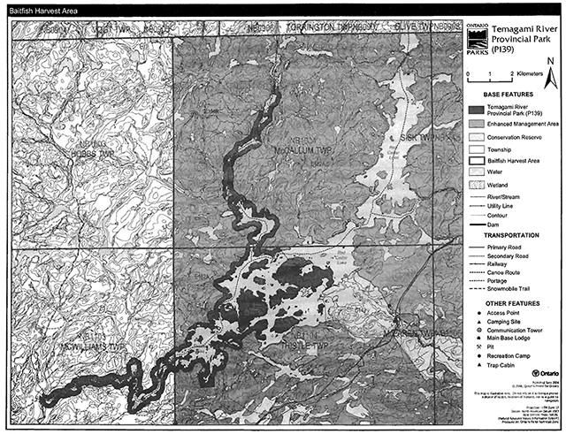
Commercial baitfish harvesting
There are portions of three baitfish licence areas within the park (Figure 5). This activity may be subject to conditions identified through future park management planning or fisheries management plans. New baitfish licenses will not be permitted (OMNR 2000a; 2003).
Fish stocking
Fish stocking does not currently occur in the water bodies contained within the park boundary. The stocking of native fish species may be considered through park management planning, with full public and Aboriginal consultation. Non-native fish species will not deliberately be introduced into park waters (OMNR 1992).
Figure 5: Commercial baitfish harvesting
Enlarge figure 5 commercial baitfish harvesting map
6.0 Operations policies
6.1 Recreation management
Future planning, with full public and Aboriginal consultation, will review direction on motorized and non-motorized recreation uses.
6.1.1 Motorized recreation
Motorboats
The use of motorboats is permitted to continue, unless park values are being threatened (OMNR 2004a).
Aircraft
Aircraft landings are permitted in the park (OMNR 2004a). All aircraft landings are subject to regulation and valid aircraft landing permits issued by the park superintendent under the authority of the Provincial Parks Act.
Snowmobiles
There are currently no authorized snowmobile trails located within the boundary of Temagami River Provincial Park. Proposals for new trails may only be considered through future planning with public and Aboriginal consultation (OMNR 2000a).
Snowmobile use on existing routes for access to private land in-holdings, LUPs, and recreational ice fishing may continue unless park values are threatened.
All-terrain vehicles
The use of authorized ATV trails is permitted to continue (OMNR 2004a).
The use of unauthorized trails by ATVs is not permitted. MNR district and Ontario Parks will work to discontinue this unauthorized use in the park.
The use of ATVs on existing trails for access to private land in-holdings and LUPs is permitted to continue unless park values are threatened. Proposals for new trails may only be considered through future planning with public and Aboriginal consultation (OMNR 2000).
Off-road/off-trail use of all-terrain vehicles will not be permitted within park boundaries unless authorized by the superintendent under the authority of the Provincial Parks Act.
6.1.2 Non-motorized recreation
Camping
There are currently no developed camping facilities within Temagami River Provincial Park. However, there are several unmanaged campsites located within the park boundary that are associated with the canoe route. Ontario Parks may assess the condition of existing campsites and will maintain, rehabilitate or close sites as required. If there is an identified need, new backcountry campsites may be considered (OMNR 2004a). Infrastructure will be permitted in order to protect park features and values in response to use, environmental deterioration and environmental protection requirements. Any proposed development in the park must fulfill the requirements of the Environmental Assessment Act.
Hiking
There are no designated hiking trails in Temagami River Provincial Park.
If there is an identified need, the development of new hiking trails may be considered. Trail infrastructure to protect park values and features will be permitted. Any proposed development within the park is subject to Environmental Assessment Act requirements.
Canoeing/kayaking
There is an existing canoe route along the length of the park. Portages will be managed to provide safe passage- non compatible uses are prohibited (e.g., ATVs). Existing uses may continue, unless park values are threatened (OMNR 2004a). Infrastructure to protect park features and values may be permitted and developed in response to use, environmental deterioration, and environmental protection requirements.
6.1.3 Emerging recreation uses
There are emerging recreational uses for which there is limited or no policy to deal with their management (e.g., adventure racing, geocaching). The park superintendent will use legislation, policy and guidelines which are in place to manage emerging uses.
6.2 Development
There is no existing infrastructure located within the park boundary. Infrastructure to protect park features and values may be permitted and developed in response to use, environmental deterioration and environmental protection requirements. Any proposed development within the park is subject to MNR's requirements under the Environmental Assessment Act.
6.3 Commercial tourism
There is no infrastructure for commercial tourism within the park. New commercial tourism facilities may be considered where consistent with park policy (OMNR 2004a). Any development must meet the requirements of the Environmental Assessment Act.
7.0 Cultural resources
An assessment of the cultural resources specific to Temagami River Provincial Park has not been completed; however upon completion, the management of all cultural values within this park will be directed toward protection and heritage appreciation (OMNR 1992).
8.0 Heritage education
Literature, maps and other supporting information may be developed to describe the park in the context of Ontario’s provincial park system. Boundary limits, significant heritage features and permitted uses of the water-Way park may be included in park information.
Prospective park visitors may be informed about the sensitivity and significance of park values through park information.
9.0 Research
Scientific research by qualified individuals which contributes to the knowledge of natural or cultural history, or to environmental or recreational management, may be encouraged in the park. Ontario Parks will encourage institutions, such as universities, to undertake research projects.
All research programs will require the approval of Ontario Parks and are subject to park policy and other applicable legislation. Any materials removed from the park will remain the property of Ontario Parks.
Approved research activities and facilities will be compatible with the park’s protection objective. Any site which is affected by research will be rehabilitated as closely as possible to its original state. Environmental Assessment Act requirements will apply.
10.0 References
Acres International Limited, 1992. Sturgeon River/Lake Nipissing/French River Water Management Plan. Sturgeon - Nipissing - French Water Management Advisory Board I Ontario Ministry of Natural Resources.
Environmental Assessment Act, 1990
Fisheries Act, 1985
Fish and Wildlife Conservation Act, 1999.
Frey, E. and D. Duba, 2002. Earth Science Checksheet - P139 Temagami River Provincial Park.
Hodgins, B. and J. Benidickson, 1989. The Temagami Experience. University of Toronto Press.
Kershaw, W.L., 2002. Recreation Assessment - Temagami River Provincial Park Inventory Report - Version 2.0.
Mining Act, 1990.
Morris, E.R., 2001. Natural Heritage Life Science Checksheet - Temagami River Provincial Park.
Ontario Ministry of Natural Resources, 1974. A Topical Organization of Ontario History. Historic Sites Branch Division of Parks.
Ontario Ministry of Natural Resources, 1992. Ontario Provincial Parks Planning and Management Policies.
Ontario Ministry of Natural Resources, 1999. Ontario’s Living Legacy Land Use Strategy.
Ontario Ministry of Natural Resources, 2000a. Ontario’s Living Legacy Land Use Strategy (Policy Clarification).
Ontario Ministry of Natural Resources, 2000b. Public and Aboriginal Consultation Documentation Form - Ontario’s Living Legacy Protected Area Boundary Refinement Review.
Ontario Ministry of Natural Resources, 2003. Directions for Commercial Resource Use Activities in Provincial Parks and Conservation Reserves. 5 pp.
Ontario Ministry of Natural Resources, 2004a. Crown Land Use Policy Atlas.
Ontario Ministry of Natural Resources, 2004b. Forest Fire Management Strategy for Ontario. Aviation and Fire Management Branch.
Ontario Ministry of Natural Resources, 2005a. A Class Environmental Assessment for Provincial Parks and Conservation Reserves.
Ontario Ministry of Natural Resources, 2005b. List of Forest Management Units and Forest Management Plan Renewal Schedule 2005.
Speck F.G. 1915. Family Hunting Territories and Social Life of Various Algonquin Bands of the Ottawa Valley, Ottawa: Geological Survey, Dept. of Mines, Gov. Printing Bureau.
Wilson, H. 2004. Canoeing, Kayaking and Hiking Temagami. Boston Mill Press. pp. 151.
Appendix A: Background information
| Name | Temagami River Provincial Park (P139) |
|---|---|
| Classification | Waterway |
| Ecoregion/Ecodistrict | 4E-4 (Temagami), 5E-6 (Tomiko) |
| OMNR Administrative Region/District | Northeast – North Bay |
| Total Area (ha) | 3,394 |
| Regulation date & number | December 21st, 2000 (O. Reg. 685/00) |
Representation
Earth science:
Temagami River Provincial Park is in the north-eastern part of the Grenville Front Tectonic Zone of the Ontario Central Gneiss Belt, in the north-western part of the Grenville Province. The main bedrock types of Temagami River Provincial Park include gneissic coarse metasediments and migmatitic and gneissic granitic intrusive rocks.
The surficial deposits of Temagami River Provincial Park are Late Wisconsinan in age. The small areas of bedrock uplands along the shoreline of the Temagami River have a discontinuous till cover of thin sandy-silty ground moraine.
Life science:
The Temagami River Provincial Park is located in the southern edge of Ecodistrict 4E-4. A small portion of the park is also located in Ecodistrict 5E-6. The upper portions of the river are typically flanked by white cedar (Thuja occidentalis) and yellow birch (Betula alleghaniensis) near the shore, and mature or old pine - mixed hardwood communities on the valley slopes. Old pine communities, as well as black ash (Fraxinus nigra) swamps, mixed hardwood uplands, and tolerant hardwood uplands are found in the Red Cedar and Thistle Lakes area. The lower section of the Temagami River includes mixed pine communities on the north shore, and pine - hardwood forests on the south shore. Black ash swamps and open wetlands are also present in the lower section.
Major ecosites of the Temagami River Provincial Park include white pine (Pinus strobus) mixed woods, red maple (Acer rubrum) - red oak (Quercus rubra) uplands, sugar maple (Acer saccharum) forests, intolerant hardwood forests, moderately-rich coniferous forests, and rich coniferous forests.
Cultural resources:
An investigation and analysis of the cultural resources specific to Temagami River Provincial Park has not been completed at this time.
Recreation and tourism:
The Temagami River has a reputation as an accessible white water river with numerous swifts, chutes, and rapids, but it also has a striking lake land cottage setting. The Temagami River tends to have higher than normal summer flows compared to other rivers in this area. This is likely the result of Lake Temagami and Cross Lake in the river’s headwaters sustaining the summer flows.
The Temagami River was identified as providing a 'natural river' experience on the portions of the river that are included in the park. The Red Cedar and Thistle lakes in the park, and Cross Lake to the north and the Temagami River below the park could be classed as providing 'modified river' experiences. For an explanation of the river classification please refer to the recreation assessment inventory for Ternagarni River Provincial Park.
A variety of recreation pursuits occur along the river. These include land based and water based activities: canoeing, kayaking, cottaging, motor boating, fishing, camping, hunting, landscape viewing, snowmobiling and wildlife viewing.
Inventories
| Survey level | Earth science | Life science | Cultural | Recreational |
|---|---|---|---|---|
| Reconnaissance | Frey and Duba, 2002 | Morris, 2001 | Kershaw, 2002 |
Footnotes
- footnote[1] Back to paragraph Transfers include situations where a license is surrendered with a request that it be immediately reissued to another individual or organization that is assuming an existing operation. Trap cabins are considered part of a trapline and would be transferred with the trapline for the purposes of trapping. If a trapline license is revoked or surrendered, all portions of the registered line within the park will be rescinded from the legal description of the trap line (OMNR 2003).