Thessalon River Delta/Rock Lake Red Oak Conservation Reserve Management Statement
This document provides policy direction for the protection, development and management of the Thessalon River Delta/Rock Lake Red Oak Conservation Reserve and its resources.
(C258)
Statement of Conservation Interest
Ministry of Natural Resources
Algoma Area
Sault Ste. Marie District
March 4, 2003
Ce document est seulement disponible en anglais.
Approval statement
I am pleased to approve this Statement of Conservation Interest (SCI) for the Thessalon River Delta/Rock Lake Red Oak Conservation Reserve (C258).
The Thessalon River Delta/Rock Lake Red Oak Conservation Reserve protects red oak (Quercus rubra L.), a species occurring on the northern limits of its range, and sugar maple (Acer saccharum Marsh.) forests. Regulated on April 6, 2001, this 295-hectare conservation reserve is situated approximately 16 kilometres north of the town of Bruce Mines, in Aberdeen Township.
Direction for establishing, planning and managing conservation reserves is defined under the Public Lands Act and current policy. The direction for managing this conservation reserve is in the form of a SCI, which defines the area that is being planned, provides the purpose for which the conservation reserve has been proposed, and outlines the Ministry of Natural Resources' intent for the protected area. This SCI will provide both guidance for the management of the conservation reserve and the basis for ongoing monitoring of activities. More detailed direction at this time is not anticipated. However, should significant facility development be considered or complex issues arise requiring additional studies, more defined management direction in the form of special protection measures, or a detailed Resource Management Plan will be prepared with full public consultation.
Public and Aboriginal consultation occurred prior to the regulation of this conservation reserve during the planning for Ontario’s Living Legacy (OMNR 1999). Furthermore, there was a 15- day review period in November 2002 concerning a draft of this SCI. Comments from the review period have been considered in the development of this document.
This SCI will be implemented by the Algoma Area Supervisor, and will be reviewed every five years and amended as required by the District Planner, Sault Ste. Marie District, Ministry of Natural Resources.
Submitted by:
Erin Nixon
Date: February 28, 2003
Recommended for Approval and signed by:
Serge Tenaglia R.P.F.
District Manager
Sault Ste. Marie District
Date: March 4, 2003
Approved and signed by:
Rob Galloway
Regional Manager
Northeast Region
Date: May 30, 2003
1.0 Introduction
The following document is a Statement of Conservation Interest (SCI) for the Thessalon River Delta/Rock Lake Red Oak Conservation Reserve (C258). The purpose of this SCI is to identify and describe the natural, recreational and cultural values of Thessalon River Delta/Rock Lake Red Oak Conservation Reserve and to outline the Ministry of Natural Resources' management intent for this area. The first portion of this document highlights the provincial context in which it was produced, states its goals and objectives and summarizes the planning process for conservation reserves. The remainder of this document is specific to the Thessalon River Delta/Rock Lake Red Oak Conservation Reserve. Management direction provided within this SCI will serve to protect the conservation reserve for the benefit of all Ontario residents. This direction will comply with the land use intent stated in the Ontario’s Living Legacy Land Use Strategy (OMNR 1999).
1.1 Provincial context
Ontario’s network of natural heritage areas has been established to protect and conserve areas representative of the diversity of the natural regions of the province, including species, habitats, features and ecological systems which comprise that natural diversity. Protected natural heritage areas are a key component in the sustainable management of natural resources. They ensure that representative sites within the larger managed landscape are permanently retained in their natural state. The Thessalon River Delta/Rock Lake Red Oak Conservation Reserve is part of Ontario’s network of natural heritage areas.
On July 16, 1999, the Ontario Government released the Ontario’s Living Legacy Land Use Strategy to guide the planning and management of Ontario’s Crown lands. Extensive consultation was conducted during the development of the Land Use Strategy. The objectives of the Land Use Strategy (OMNR 1999) are to complete Ontario’s system of parks and protected areas; recognize the land use needs of the resource-based tourism industry; provide forestry, mining and other resource industries with greater certainty around land and resource use; and enhance hunting, angling and other Crown land recreation opportunities.
The Land Use Strategy (OMNR 1999) demonstrated the government’s commitment to completing Ontario’s system of protected natural heritage areas by designating 378 new areas to be protected. These areas are considered to be significant and require protection from incompatible activities in order for their values to endure over time. The addition of these 378 new areas marks the largest expansion of parks and protected areas in Ontario’s history. The Thessalon River Delta/Rock Lake Red Oak Conservation Reserve was created as part of this expansion. It protects a provincially significant combination of red oak (Quercus rubra L.), a species occurring on the northern limits of its range, supported by rocky uplands. This site is also protected because it is the best representative example of moderately broken shallow sandy till uplands on bedrock in Site District SE-1 with high landform and vegetative diversity and sugar maple (Acer saccharum Marsh.) forests.
The Ministry of Natural Resources has established conservation reserves as a tool to protect natural heritage areas on public lands, while permitting traditional public land uses to continue. These uses include recreational activities, such as hunting and fishing, and the traditional activities of Aboriginal societies, as defined under applicable Aboriginal Treaties. Lands designated as conservation reserves in the Land Use Strategy (OMNR 1999) are removed from the Sustainable Forest Licence, and mining and surface rights are withdrawn from staking under the Mining Act (RSO 1990 Chapter M.14).
Ontario’s Living Legacy Land Use Strategy (OMNR 1999) outlines the general land use policy and management direction for new conservation reserves. Each new conservation reserve will have a planning document, either a SCI or, in more complex situations, a Resource Management Plan, that details site-specific management direction.
2.0 Goal and objectives of the SCI
2.1 Goal
The goal of this SCI is to provide the framework and direction to guide management decisions affecting the Thessalon River Delta/Rock Lake Red Oak Conservation Reserve.
2.2 Objectives
The following objectives are identified as the means to achieve the above stated goal.
- To describe the state of the resource with respect to the values identified in Section 5.0 and current land use activities
- To outline the Ministry of Natural Resources' management intent for the protected area
- To determine the land use compatibility of current land uses, and to develop specific guidelines and prescriptions to manage these uses
- To create public awareness of the values (Section 5.0) within this conservation reserve by providing information on the resources that it contains and protects; and to promote responsible stewardship of the protected area through partnerships with local stakeholders
- To determine the long-term management goals for the conservation reserve by identifying research, client services, and marketing strategies necessary to position this conservation reserve among the system of parks and protected areas in Ontario
- To identify the scientific values on the site in relation to provincial benchmarks and identify the necessary monitoring and/or research to maintain the integrity of these values
- To provide direction for the evaluation of proposed new uses or economic ventures through the application of the Test of Compatibility (Appendix A). This test will evaluate the impact of suggested use(s), either positive or negative, on the protected values of the conservation reserve
3.0 Management planning
3.1 Planning for a Conservation Reserve
The planning process for a conservation reserve consists of defining site boundaries and preparing a site specific management plan. Public, Aboriginal and industry consultations occur during the planning process. When the boundaries of the site are finalized, and the Ministry of Natural Resources' approval process is complete, a conservation reserve becomes regulated. Once a conservation reserve is regulated, the level of management planning required to fulfill the protection targets is determined, and either a basic or an enhanced SCI, or a Resource Management Plan is prepared. A basic SCI is prepared when no new decisions are made beyond those mentioned 'in the Ontario’s Living Legacy Land Use Strategy (OMNR 1999), whereas an enhanced SCI is prepared when one or more decisions are made beyond those mentioned in the Strategy. A Resource Management Plan is prepared in more complex situations where a number of issues have to be addressed. Whichever the determination, the plan must be completed within three years of the conservation reserve’s regulation date. The guidelines for the preparation of these documents are provided in Procedural Guideline A - Resource Management Planning (Conservation Reserves Procedure PL3.03.05, Public Lands Act).
A SCI is essentially a management plan based on the management direction provided in the Land Use Strategy (OMNR 1999). The purpose of a SCI is to identify the state of the resource with respect to the values identified in Section 5.0 and current land use activities, and to outline the Ministry of Natural Resources' management intent for the conservation reserve. Basic SCIs typically go through a public review period of 15 days. Upon completion of this public review, the SCI is revised as appropriate and approved by the Ministry of Natural Resources' Regional Director.
Existing permitted uses within conservation reserves may continue, unless they are shown to have a significant negative impact on the values protected by the site. A review/evaluation mechanism is in place to address proposed new permitted uses, or land use proposals. The Test of Compatibility as outlined in the Public Lands Act Policy PL 3.03.05 (OMNR 1997) and/or other standard Ministry of Natural Resources' environmental screening processes, is used to screen future proposals. Where cultural resources may be impacted, proposals may be screened through Conserving a Future for our Past: Archaeology, Land Use Planning & Development in Ontario, Section 3 (MCzCR 1997), in a manner similar to that used by the Ministry of Natural Resources in the forest management planning process.
Public comment may be solicited during a review of any future land use proposals that require new decisions to be made. Appropriate environmental assessment (EA) requirements and amendment processes will apply to any future proposal and/or any significant change in management direction being considered for a site.
3.2 Planning process for the Thessalon River Delta/Rock Lake Red Oak Conservation Reserve
Thessalon River Delta/Rock Lake Red Oak Conservation Reserve (C258) was proposed as a conservation reserve in the 1999 Ontario’s Living Legacy Land Use Strategy by the Ontario Ministry of Natural Resources. Public, Aboriginal and industry consultation has taken place and the boundary of the site has been finalized. The site was formally regulated through an amendment to Ontario Regulation 805/94 of the Public Lands Act on April 6th, 2001, by Ontario Regulation 86/01.
To date, no significant issues related to land use in this area have been identified. For this reason, it was determined that a basic SCI will adequately identify the conservation reserve’s significant features and address the management guidelines. Thessalon River Delta/Rock Lake Red Oak Conservation Reserve will be managed under the auspices of a SCI. It should be noted that this SCI addresses only those issues or land use proposals currently known to the District Manager. The direction provided by this SCI, and future management decisions, will resolve any future land use conflicts and will ensure that identified values continue to be adequately protected.
3.2.1 Planning area
The planning area for this SCI consists of the regulated boundary for the Thessalon River Delta/Rock Lake Red Oak Conservation Reserve (see Section 10, Map 1a). However, to fully protect values within the conservation reserve, additional consideration within larger land use planning initiatives may be required. The forest management planning process is an example of how adjacent land management may consider sensitive features within the conservation reserve boundary.
3.3 Guiding principles
All current or planned activities within this conservation reserve will be in compliance with the following guiding principles. If a conflict between management guidelines exists, the following guiding principles will be used to discern management intent and resolve the issue.
- All management guidelines will be based on maintaining the long-term ecological integrity of the area
- No new or existing uses will be permitted if it is deemed that they compromise the protected natural heritage values
- All attempts will be made to maintain traditional uses while protecting the values mentioned in section 0 and maintaining the long-term ecological integrity of the site
- This conservation reserve was chosen to represent vegetation and landscape types unique to this site district and All efforts will be made to maintain those values identified in Section 5.0.
- Overall, management strategies will focus on maintaining the conservation reserve in as natural a state as possible
4.0 Background information
4.1 Location and site description
Thessalon River Delta/Rock Lake Red Oak Conservation Reserve
Table 1 describes the location and administrative details of the site.
Table 1. Location and Administrative details for the Thessalon River Delta/Rock Lake Red Oak Conservation Reserve
| Name | Thessalon River Delta/Rock Lake Red Oak Conservation Reserve |
|---|---|
| Site Region - Site District (Hills) | 5E Georgian Bay 5E-1 Thessalon |
| Site region - Site District (Crins and Uhlig) | 5E-1 |
| Ministry of Natural Resources Administrative Region/District/Area | Northeast Region/Sault Ste. Marie District/Algoma Area |
| UTM co-ordinates | 288335 E 5147887 N - Zone 17 |
| SCI Completed | February 12, 2003 |
| Regulated | April 6 2001 |
| Area | 295 ha |
| Nearest Town/Municipality | Approximately 16 km north of the Town of Bruce Mines |
| Township(s) | Aberdeen |
| OBM Numbers | 20 17 2800 51400 |
| Topographical Map Name/Number | Bruce Mines/41J/5 |
| Wildlife Management Unit | 36 |
| Forest Unit | Algoma Forest |
4.2 History of the site
In the 1870s, activities such as agriculture and logging began to prosper around the Town of Bruce Mines to help support the mining economy. The rich lowlands of southern Aberdeen Township quickly became the foundation for increasing agricultural activities (Mcleod 2001). The Rock Lake mine site was developed in 1899, and in 1902 a railroad was constructed to connect Bruce Mines to this mine site. The Rock Lake Mine closed a short time later in the summer of 1903 (Anonymous 1999). The railroad was then used to transport lumber, firewood and hay. After World War I, the railway was no longer used to transport these resources; instead, it operated as an early tourism railway, bringing people to Rock Lake for weekend fishing trips and picnics until 1921. The last of the rails were removed during World War II. The steel rails were most likely melted down in the blast furnaces of Algoma Steel Inc. to support the war effort (Hughes 2001).
Indian Lake comprises part of the Thessalon River Delta/Rock Lake Red Oak Conservation Reserve’s boundary. According to long-time residents of the area, Indian Lake got its name around the turn of the century when the first pioneers witnessed Aboriginal people spear fishing in this lake (Mcleod 2001). There are unconfirmed reports that a First Nations cemetery exists somewhere around Indian Lake and potentially within this conservation reserve (Mcleod 2001).
Rock Lake’s past mining activities have served to enhance the recreational opportunities available in this conservation reserve. Old Mill Beach Road was originally constructed to transport mined material from the mine site to the mill and is now used as an access point for Rock Lake. Mine tailings that were discarded into the lake are partially responsible for the creation of Old Mill Beach, the most popular recreational feature in this site. Snowmobiles and ATVs also commonly use portions of the old rail bed.
An open mineshaft of archeological and historical significance is present just north of the access point on Rock Lake.
4.3 Inventories
Table 2 indicates the current status of natural heritage inventories that have occurred and/or are required for the Thessalon River Delta/Rock Lake Red Oak Conservation Reserve.
Table 2: Inventory and Survey Information for the Thessalon R1ver Delta/Rock Lake Red Oak Conservation Reserve.
| Survey Level | Earth Science | Life Science | Cultural | Recreational |
|---|---|---|---|---|
| Reconnaissance | 2001 | 2001 | 2001 | 2001 |
| Detailed | Not required | Not required | Not required | Not required |
| Further Requirements | An assessment of red oak regeneration should be completed. | An assessment of recreational structures (i.e. outhouses and fire pits) should be completed. |
5.0 State of the resource
The key values (geological features and/or featured species) found within the Thessalon River Delta/Rock Lake Red Oak Conservation Reserve include the following:
- The best representative example of moderately broken shallow sandy till uplands on bedrock in Site District SE-1
- A provincially significant combination of red oak supported by rocky uplands
- High landform and vegetative diversity in a unique landform pattern that is oriented from northwest to southeast
The key values are those values that make this site unique and have led to its designation as a conservation reserve. Their protection is paramount. Additional values as listed in Section 5.1 through to Section 5.5 are also important. This description is not necessarily complete. If new values are identified, they will be added to this section. If any new value is considered significant, management guidelines may be modified, if required, to ensure its protection.
5.1 Earth sciences
The Thessalon River Delta/Rock Lake Red Oak Conservation Reserve is located along the edge of the Canadian Shield, which is composed of Precambrian bedrock, and is just within the southern limits of the Abitibi Uplands subdivision. In Ontario, the Abitibi Uplands physiographic area is further divided into the Cobalt Plain in the east and the Penokean Hills in the west, which forms the north shore of Lake Huron. The Thessalon River Delta/Rock Lake Red Oak Conservation Reserve is located within the Penokean Hills physiographic area. This landscape is controlled by folded Proterozoic
This site is the best representation of moderately broken shallow sandy till uplands on bedrock within Site District SE-1. The landform types are dominated by exposed bedrock (i.e. greater than 5O% bedrock exposed) ridges that are oriented approximately in the northwest to bedrock southeast direction, and bedrock drift complexes containing areas of exposed bedrock and discontinuous drift. The majority of this conservation reserve consists of a glacial high relief bedrock knob terrain with variable depths of ground moraine (sandy till). Consequently, bedrock outcrops to sheer rock cliffs with spectacular horizontal summits can be found throughout (OMNR 2000).
Some glaciolacustrine deposits are present, and are concentrated in the northwestern section of the site. They are associated with the eastern shoreline of Indian Lake, or within a concave northwest to southeast trough behind the sandy beach area located on Rock Lake. The lacustrine sand at Rock Lake beach is supplemented by quartzite fragments from a past mining operation. The beach and glaciolacustrine sediment may be susceptible to erosion if the vegetation layer is disturbed (OMNR 2000).
A portion of the area to the northeast is on less rugged terrain; it has deeper soils, less exposed bedrock and dense tree cover (OMNR 2000). These richer soils support farming activities outside the boundary of the conservation reserve.
5.2 Life sciences
Based on field studies conducted in 1998 by Bergsma and an aerial reconnaissance survey completed by the Ministry of Natural Resources in October 2000, the site contains a minimum of 42 landform/vegetation combinations, which is high for such a small site. The proportion of cover types is somewhat skewed towards the maple and oak dominated communities. However, the largest community is a red oak, predominately deciduous mixed-wood that makes up approximately 10% of the site. In addition, most forest stands observed contain a wide assemblage of tree species. Wetland and aquatic values within the site add to the site’s diversity but are not considered significant. Associated wetland and aquatic systems adjacent to the site complement the current conservation reserve’s values.
Generally, the forests in this conservation reserve are very dense with a limited herbaceous and woody understory. Sugar maple and red oak are found dominating most of the ridges; however, eastern white pine (Pinus strobus L.) grows throughout, especially on the side slopes with pockets of white cedar in the moist bedrock valleys. The forests closest to Rock Lake are primarily mixed-woods, with components of trembling aspen (Populus tremuloides Michx.), red oak, sugar maple, eastern white cedar (Thuja occidentalis L.), balsam fir (Abies balsamea (L.) Mill.) and white spruce (Picea glauca (Moench) Voss). Maple dominates the dense forests of the northern part of the conservation reserve, with many large solitary red oaks existing in the overstory. Historically, this maple dominated stand consisted mainly of red oak; however, due to insufficient natural disturbances such as fire (Farrar 1995), the oak has not regenerated. Instead, shade tolerant sugar maple has assumed dominance and now exclusively composes the understory (Farrar 1995).
A major red oak community is located within the southern extent of the site, with stands extending beyond the southeast border. This red oak, predominately deciduous mixed-wood community is located over bedrock and bedrock drift landforms, and has been designated as provincially significant (Bergsma 1998). Also present are silver maple, trembling aspen, yellow birch and white pine species.
The Thessalon River Delta/Rock Lake Red Oak Conservation Reserve and surrounding area provides habitat for a variety of faunal species. The Rock Lake area is an identified deeryard and has been managed as such since 1983. A number of wildlife features are adjacent to the conservation reserve and contribute to its richness. Extensive wetland areas around Indian Lake and at the mouth of the Thessalon River are important waterfowl staging areas. Wetlands associated with the Thessalon River support a resident population of dabbling ducks. These wetlands also provide an important stop-over for migratory geese and a variety of ducks such as scaup (Aythya sp.), teal (Anas sp.), ring-necked duck (Aythya collaris), common goldeneye (Bucephala clanga americana), bufflehead (Bucephala albeola), mallard (Anas platyrhynchos) and american black duck (Anas rubripes). In fact, several hundred scaup have been seen utilizing the wetlands of Rock Lake at one time (OMNR(a) 2001).
The Thessalon River upstream of the delta provides spawning areas for fish species such as brook trout (Salvelinus fontinalis fontinalis), walleye (Stizostedion vitreum vitreum) and rainbow trout (Oncorhynchus mykiss). Lake sturgeon (Acipenser fluvescens) may also use the upper Thessalon River for spawning. Indian Lake has historically been known as an important spawning area for northern pike (Esox lucius) from Rock Lake. The wetland areas of the delta may provide spawning opportunities for species such as northern pike, yellow perch (Perea flavescens) and brown bullheads (Ameiurus nebulosus).
Rock Lake marks the southern boundary of the conservation reserve, and can be accessed via a public boat launch located within the conservation reserve. The lake’s warm water has historically supported abundant walleye, but fishing pressures have decreased the size and abundance of this species. In addition to walleye, this lake now contains yellow perch, rainbow trout, northern pike and lake sturgeon (OMNR 1995).
5.3 Recreational values
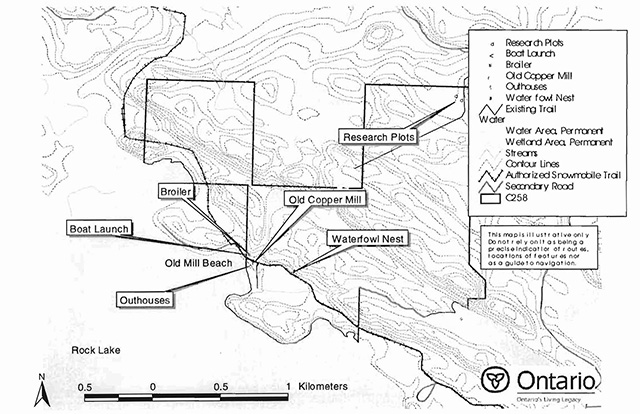
Old Mill Beach on Rock Lake is one of the most commonly used recreational features in the conservation reserve (See Section 9.2). The surrounding communities place high value on this relatively sandy beach, as much of the remaining shoreline near this site consists of rubble and cobble (OMNR 2000). The day-use potential of this beach has been enhanced by the additions of a boat launch, two outhouses and concrete fire pits.
Old Mill Beach Road cuts through the southeast corner of the site providing access to Old Mill Beach, as well as a number of cottages located on private land next to the conservation reserve. Menard Road provides access to the site from the north, and a snowmobile trail bisects two of the center blocks of the conservation reserve.
Rock Lake forms much of the southern boundary of the conservation reserve and is used for fishing and recreational boating. Public access to Rock Lake is achieved via the boat launch located at Old Mill Beach. There are numerous sport fish species in this lake as identified in Section 3.3.2. However, according to the Guide to Eating Ontario Sport Fish (MOE 2001), the lake’s Walleye and Northern Pike are known to have dangerous levels of mercury.
This conservation reserve supports many different hunting opportunities. The interior harbors a seasonal deer population, and the wetlands and shoreline provide habitat for local and migrating populations of geese and ducks. The importance of this conservation reserve for hunting is high, as it is an area of Crown land in an area otherwise dominated by private land.
An Ontario Federation of Snowmobile Clubs (OFSC) authorized snowmobile trail traverses the southern portion of the conservation reserve (See Section 10.2). This trail appears to be used by ATV operators during the non-winter months. In addition, an existing trail is located in the northeastern portion of this conservation reserve. This trail starts at Highway 638, entering at the northeast corner of the site and heads southwest, allowing access to two Forest Ecosystem Classification (FEC) research plots (please refer to Section 5.5 for more information on research).
5.4 Cultural values
This site falls within the Robinson-Huron Treaty area. No First Nation community has to date identified any specific cultural values within its boundaries.
5.5 Research values
There are two Forest Ecosystem Classification (FEC) research plots in the northeast corner of this site. These plots are part of a network of plots established throughout the Northeast Region in the early 1990s. Research is ongoing, and these plots are likely to be revisited in the future.
6.0 Management guidelines
All management guidelines in this SCI are based on policy and direction outlined in the Ontario Living Legacy Land Use Strategy (OMNR, 1999) and associated policy clarification statements. Management policies in this document may be subject to change and may be amended as necessary. These guidelines are specific to Thessalon River Delta/Rock Lake Red Oak Conservation Reserve, and provide for protection of the site’s unique features.
New proposed uses and development as well as research and education will be reviewed on a case-by-case basis. The Test of Compatibility (Appendix A - PL 3.03.03, Public Lands Act) must be passed with reference to Conserving a Future for our Past: Archaeology, Land Use Planning & Development in Ontario, Section 3 (MCzCR 1997) before new proposals will be permitted. In addition, all new proposals are subject to the Class Environmental Assessment for Parks and Conservation Reserves.
The following management strategies have been created to achieve the goal and objectives of this SCI with regard to Thessalon River Delta/Rock Lake Red Oak Conservation Reserve.
6.1 Industrial activities
6.1.1 Commercial timber harvest
The area of this conservation reserve (295 ha) has been withdrawn from the Algoma Sustainable Forest Licence area and no commercial timber harvesting is permitted. Please refer to Section 6.4.3 for information regarding non-commercial harvesting of wood.
6.1.2 Mining and exploration
There are no known current mining interests related to the conservation reserve. Mining and surface rights have been withdrawn from staking within the conservation reserve’s boundaries under the Mining Act (RSO 1990 Chapter M.14). Mineral exploration is not permitted.
6.1.3 Extraction of peat, soil, aggregate and other material
Extraction of peat, soil, aggregate and other material is not permitted.
6.1.4 Energy generation
Hydropower development and windpower generation is not permitted.
6.2 Existing and proposed development
6.2.1 Transportation corridors
6.2.1.1 Roads
According to the Land Use Strategy (OMNR 1999), new roads for resource extraction will not be permitted, except for those identified in Forest Management Plans prior to March 31, 1999. This process identified no new or existing roads for resource extraction within this site.
There is one existing secondary road used to access Old Mill Beach in this conservation reserve. This road is considered to be consistent with traditional recreational uses and protected values. Upgrades to this road will be considered if protected natural and geological features are not significantly compromised, and will be subject to the Test of Compatibility (Appendix A).
6.2.1.2 Trails
Existing and/or authorized trails can continue unless there are significant demonstrated conflicts. Presently, an authorized Ontario Federation of Snowmobile Clubs (OFSC) snowmobile trail traverses the southern portion of the conservation reserve. This trail is permitted to continue for snowmobile activities as well as for associated off-season activities. Existing trails for hiking, snowmobiling, ATV use, cycling, horse riding and cross-country skiing, such as the one identified in the northeast part of this conservation reserve, can continue.
Any future trail development must consider the conservation reserve’s core values that are protected within the boundaries of this site. Trail development in low-lying areas and wetlands will be discouraged. Any proposed new trails will be subject to the work permit review process and the Test of Compatibility screening process (Appendix A). All new and existing trail heads and trail routes must be identified using new technologies (i.e. global positioning systems) to ensure the most accurate record of the feature. If new trails are approved, an amendment to this SCI will occur
6.2.2 Other corridor development/maintenance
There are no communication, energy transmission, or other non-road corridors within this conservation reserve. New corridor developments will be actively discouraged through planning. Proposals for new corridors will be subject to the Test of Compatibility (Appendix A) and applicable district policies.
6.2.3 Land disposition
No land will be sold within the boundaries of this conservation reserve.
6.2.4 Land tenure
Presently there are no Land Use Permits or leases within this conservation reserve. With the exception of private recreation camps, new leases or land use permits may be issued for other approved uses subject to the Test of Compatibility (Appendix A) and applicable district policies.
These forms of land tenure will neither be patented nor phased out but may be eligible for enhanced tenure or transfer. Enhanced tenure is defined as anything beyond the term and form of current tenure. All requests for transfer or enhanced tenure will be subject to the following screening criteria:
- Is the transfer or enhanced tenure consistent with the conservation reserve’s land use intent, which is the protection and enhancement of the site’s natural, recreational and cultural values?
- Is it consistent with the land disposition policies outlined in the District Land Use Guidelines, the Crown Land Use Atlas, this SCI and any other applicable document?
- Does it adversely affect the values as stated in Section 5.0, and/or conflict with other uses?
- Is land needed by the Crown to protect significant natural or recreational values outlined in this SCI?
- Does the transfer or enhanced tenure clash with Aboriginal traditional uses, land claims or agreements?
- Are all rents, taxes, fees, rates or charges paid up for the existing Land Use Permit or lease?
6.3 Commercial activities
6.3.1 Commercial bait harvesting
No active commercial bait harvest operations or licences currently exist within this conservation reserve. New operations can be considered within the conservation reserve subject to the Test of Compatibility (Appendix A) and applicable district policies.
Under the Public Lands Act and in conjunction with PL 3.03.08 "Buildings for Bait Harvesting Management", cabins for the purpose of bait harvesting may be constructed on Crown land. However, the construction of such buildings within this conservation reserve should be avoided, and be directed to Crown land outside of the protected area wherever possible.
6.3.2 Commercial fishing
There are no commercial fisheries within this conservation reserve.
6.3.3 Commercial fur trapping
Portions of Registered Trapline Area SS-PL-02 fall within the boundary of this conservation reserve. This registered trapline area is currently allocated to a head trapper and is considered an existing operation. If a head trapper surrenders a registered trapline, or the head trapper’s privileges are revoked, the registered trapline may be transferred to another trapper following established allocation procedures. If the registered trapline is not transferred in due course, or remains unallocated for a significant period of time, reallocation of the trapline may occur following applicable district screening processes.
The establishment of new trapline trails will be considered following the procedure and criteria for new trails as outlined for trails in Section 6.2.1.2.
No trap cabins currently exist within this conservation reserve. The establishment of new trap cabins will not be permitted within the conservation reserve.
6.3.4 Bear Management Areas
There is no history of a Bear Management Area (BMA) within the boundaries of this conservation reserve. In compliance with the direction outlined in the Land Use Strategy (OMNR 1999), new BMA operations will not be permitted.
6.3.5 Commercial food collection
There are no existing, commercial food harvesting ventures within this conservation reserve. New ventures will be subject to the Test of Compatibility (Appendix A) and the appropriate Ministry of Natural Resources' policies and procedures.
6.3.6 Commercial non-timber forest products
Policy regarding commercial non-timber forest products is currently being developed by the Planning and Research Section of Ontario Parks. In the interim, proposals will be reviewed on a case-by-case basis, subject to the Test of Compatibility and applicable district policies.
6.3.7 Outpost camps/main base lodges
There are no existing authorized outpost camps or main base lodges within this conservation reserve. New outpost camps and main base lodges may be considered through planning and will be subject to the Test of Compatibility (Appendix A) and applicable district policies.
6.4 Non-commercial activities
6.4.1 Nature appreciation/recreation activities
Off-trail hiking, cross-country skiing, and other activities will be permitted within this conservation reserve. However, should the impact of these activities degrade the landscape of the conservation reserve, the Ministry will re-evaluate these permitted uses and decide upon a new strategy for this site. New trails to support these activities may be considered; see Section 6.2.1.2 on trails for more details.
While camping is permitted within the conservation reserve, camping is not permitted on Old Mill Beach. Campers should also avoid sensitive areas such as wetlands.
6.4.2 Natural heritage appreciation facilities/recreational structures
Natural heritage appreciation facilities and recreational structures include such things as boardwalks, bird viewing platforms, kiosks, ski shelters, and interpretative signs. There are currently two outhouses and fire rings located at Old Mill Beach. These are the only existing authorized structures within this conservation reserve. New natural heritage appreciation facilities and recreation structures are encouraged and permitted, subject to the Test of Compatibility (Appendix A).
6.4.3 Non-commercial consumptive resource use
Cutting of trees for non-commercial purposes may be authorized by permit issued by the local Ministry of Natural Resources' Office, subject to a review and determination of the impact that such cutting would have on the values identified in Section 5.0. This flexibility is intended only for leaseholders, Land Use Permit holders, cottagers and other property owners within the conservation reserve who do not have road access to their property and have no alternative wood source outside of the conservation reserve. This permit is intended to cover fuelwood dock stringers, and other occasional small scale uses.
It should be noted that the red oak and mature sugar maple communities found in this conservation have been identified as significant features and harvesting of these species is prohibited.
Non-commercial harvesting of non-timber forest products such as berries, mushrooms, sphagnum moss (Sphagnum spp.) and wild rice (Zizania L.) can occur as long as the values of the site, as mentioned in Section 5.0, are not jeopardized.
6.4.4 Hunting and fishing
Hunting is a traditional use and has been identified as an important value of this area. In conjunction with current hunting regulations and adherence to the guiding principles (Section 3.3) of this conservation reserve, hunting is permitted to continue.
Recreational fishing is also permitted within this conservation reserve in compliance with current fishing regulations.
6.4.5 ATV and snowmobile use
ATV and snowmobile use will be permitted on the authorized trail within the conservation reserve. Please refer to Section 6.2.1.2 for more information on trails. In general, off-trail use of ATVs and snowmobiles is not permitted within this conservation reserve. However, off-trail use is accepted for licenced trappers to access their traplines and for licenced bait harvest operators while conducting harvest operations. Off-trail ATV and snowmobiling is also accepted for the direct retrieval of large game by hunters and of bears harvested within a current Bear Management Area. In all cases, off-trail use is only permitted provided the protection of the site’s values is not compromised. Should the impact of off-trail ATV and snowmobile use degrade the landscape of the conservation reserve, the Ministry of Natural Resources will reevaluate these permitted uses and determine a new strategy.
6.5 Resource management activities
Resource management activities are tools used to protect and enhance the values of this conservation reserve. Some management activities may require the use of intrusive techniques. Some of these techniques, under normal circumstances, would not be permitted to occur in the conservation reserve; however, if they are found to be necessary, they may be applied under controlled conditions, to achieve a desired result. Infrastructure such as roads, trails and buildings may need to be constructed to perform activities such as prescribed burns, forest regeneration, wildfire control, and insect and disease control. Activities described in this section will be deemed acceptable if the ultimate outcome is in compliance with the guiding principles of this SCI.
6.5.1 Fish stocking
No water bodies within this conservation reserve have been stocked or are currently being considered for stocking.
6.5.2 Insect and disease control
In accordance with the guiding principles, this conservation reserve will be maintained in as natural a state as possible. Insect and disease control measures should only be considered if the identified values (e.g. red oak) are significantly threatened.
6.5.3 Fire management
Fire protection will be carried out in accordance with current Ministry of Natural Resources' fire management strategies. When aggressive fire suppression is undertaken, techniques that may excessively damage the site, such as heavy equipment use, trenching, camp construction, tree cutting, etc., should be avoided within the conservation reserve except where the occurrence of a deep seated peat Fire burn may require an excavation. If it is deemed that human life or property is in jeopardy, all necessary fire suppression measures should be undertaken regardless of potential damage to any of the site’s protected values.
Prescribed burning may be permitted within this conservation reserve if it is determined that the features of this site would benefit from controlled burning (e.g. to promote red oak regeneration).
6.5.4 Management for key values
Management that maintains or improves the condition of the site’s key values is permitted on a case-by-case basis and is subject to the Test of Compatibility (Appendix A). Management may also include habitat or ecosystem management. Please refer to Section 5.0 for a list of the site’s key values.
6.5.5 Forest renewal
The preferred regeneration option after any natural disturbance is natural regeneration. In some cases, regeneration may be artificially assisted (e.g. tree removal, tree planting) when it is deemed appropriate to mitigate against human disturbances (e.g. illegal occupation and trespass).
6.6 Research
Scientific research is encouraged, by qualified individuals or institutions, that contributes to a better understanding of the natural and cultural values protected by this conservation reserve or that advances the protection, planning and management of these values. The Sault Ste. Marie District Planner should be contacted for information on research and/or monitoring opportunities within this conservation reserve. Proposals to conduct research should directed to the Algoma Area Supervisor, Ministry of Natural Resources, Sault Ste. Marie District Office, and will be subject to the Test of Compatibility (Appendix A), to ensure that no values will be damaged in the process. Any site that is disturbed during research activities is to be rehabilitated as closely as possible to its original condition. Research programs will also be subject to Ministry policies and other legislation. Collecting may only be permitted as part of an authorized research project.
Existing Forest Resource Inventory surveys and approved resource monitoring activities are permitted to continue.
Thessalon River Delta/Rock Lake Red Oak Conservation Reserve should be considered as a potential research and/or monitoring area due to the presence of mature red oak communities.
6.7 Marketing
No active marketing of this conservation reserve is currently taking place.
6.8 First nations
Traditional activities and Aboriginal rights as defined in the Robinson-Huron Treaty and other relevant acts will not be affected within the boundaries of this conservation reserve.
7.0 Recommendations
7.1 Additions to the Conservation Reserve
Many of the significant landforms and forest communities present within the Thessalon River Delta/Rock Lake Red Oak Conservation Reserve extend beyond the site’s boundaries onto private land. If the opportunity arises, additional protection of the site’s forest communities may be considered within a broader planning process. Programs such as Room to Grow may provide the opportunity to add additional land to protected areas where it is deemed appropriate.
7.2 Future needs and considerations
The following recommendations should be considered in any future planning initiatives for this conservation reserve:
- Efforts should be made to work with partners (such as Sault College of Applied Arts and Technology) to gather baseline data on this This data will be used for future monitoring and inspection activities when required
- Efforts should be made to complete further inventory requirements for this site
- The site’s significant features should be mapped for future reference
- Securing a partner to manage and maintain the Rock Lake access point is Public use of this area is high, and unlawful overnight camping is currently occurring. Evidence suggests authorized control at this site may be of value
- Erosion and rutting were observed on the snowmobile/ATV trail in the southeastern portion of the conservation Erosion caused by this trail should be periodically monitored. Action should be taken to reduce erosion if it is found to be negatively impacting any of the site’s values
- It is recommended that consideration be given to connecting the existing trail in the northern portion of the conservation reserve to the road in the south This would promote and enhance the recreational features of this conservation reserve and allow easier public access to the trail. The conservation reserve contains a series of parallel, rounded rock ridges, some with very steep slopes. Many of these rock ridges have level summits that provide natural lookouts (OMNR 2000). The combination of these ridges and the dense maple, oak and white pine forests throughout gives this conservation reserve great potential for developing networks of nature and interpretative trails. Connecting the existing trail and the road would be a good first step in developing this trail network
- As part of any future vegetative management plan, the regeneration of red oak should be addressed to sustain these communities over In addition, the vegetative management plan may take into consideration the following;
- future forest conditions for the site based on undisturbed or minimal human interference
- oak regeneration targets based on representation and the role the site plays within the parks and protected areas system within Site District SE-1
- current provincial strategies (e.g. for species such as white pine)
- larger long-term objectives for the conservation reserve (e.g. recreational objectives)
Furthermore, silvicultural assessments of red oak dominated communities and rates of regeneration presently occurring should consider but not be limited to the following objectives:
- describing the current forest condition
- determining soil type and depth
- defining potential restoration. Such prescriptions must consider current silvicultural science and guidelines and additional objectives established by the Sault Ste. Marie District and Ontario Parks
7.3 Monitoring
Periodic monitoring of human activities within this conservation reserve will be conducted. A schedule for cursory field monitoring will be identified within the District’s annual compliance plan and an Integrated Field Monitoring (IFM) Inspection Report Form will be filed at the Sault Ste. Marie District Office. The Algoma Area Supervisor will oversee these activities. If at any time human activities are deemed to be negatively impacting the protected values, the activities will be reviewed and measures taken to mitigate any disturbance. Cursory field monitoring must look at the erosion and rutting previously observed on the snowmobile trail to ensure that the conservation reserve’s values are not impacted.
Approved inventory, monitoring, assessment or research activities that are compatible with protection objectives are encouraged. Any area that is disturbed during research activities is to be rehabilitated as closely as possible to its original condition. The Algoma Area Supervisor may apply additional conditions.
8.0 Implementation, review and revisions
8.1 Responsibility
The Sault Ste. Marie District will be responsible for implementing the management policies and guidelines for the Thessalon River Delta/Rock Lake Red Oak Conservation Reserve (C258). The primary role will be to provide public information and compliance monitoring to ensure adherence to current policies and guidelines.
8.2 Review and revisions
The Thessalon River Delta/Rock Lake Red Oak Conservation Reserve SCI will be reviewed every five years by the District Planner to confirm and update the information in this document.
Revisions to this document will be subject to the requirements as specified in the Class Environmental Assessment for Provincial Parks and Conservation Reserves. If changes in management direction are needed at any time, the significance of the changes will be evaluated. Minor amendments to the plan that do not alter the overall protection objectives may be considered and approved by the Area Supervisor without further public consultation. In assessing major amendments, the need for a more detailed Resource Management Plan will first be considered. Where a Resource Management Plan is not considered necessary or feasible, a major amendment may be considered with public consultation. Major amendments will be recommended by the District Manager and approved by the Regional Director, and will follow the appropriate guidelines (OMNR 2001).
9.0 Literature cited
Anonymous, 1999. Bruce Mines & Plummer Additional. Bruce Mines Community Access Project (CAP). http://www.algoma.net/bru&plum.htm. [link no longer works]
Bergsma, B., 1998. Life Science Gap Analysis for Site District 5E-1. BMB Scientific
Bostock, H.S. 1970. Physiographic subdivisions of Canada; in Geology and Economic Minerals of Canada, Geological Survey of Canada, Economic Geology Report no. 1, p. 11-30.
Farrar, John, L., 1995. Trees in Canada. Fitzhenry & Whiteside Limited, 195 Allstate Parkway, Markham, Ontario; The Canadian Forest Service, Natural Resources Canada, Ottawa. 134-135, 248-249 pp.
Hughes, Robert J., 2001. The Ontario Railway History Page. http://www.globalserve.net/"'robkath/index.htm [link no longer works]
Mcleod, Ron and Helen, 2001. Personal communication, Blind River, Ontario
MNDM, 1898. Bureau of Mines Report, Vol. VIII. ODM Annual Report. MNDM Mines Library, Sudbury, Ontario.
MCzCR, 1997. Conserving a Future for our Past: Archeology Land Use Planning and Development in Ontario, Section 3
MOE, 2001. Guide to Eating Ontario Sport Fish. 21ed. Queen’s Printer for Ontario.
MOE, 2000. Order in Council, No.182/2000. Minister of the Environment
OMNR, 1979. Sensitive Areas and Features Report Form. Sault Ste. Marie District. No. W-H-W-12.
OMNR, 1983. District Land Use Guidelines (DLUG): Sault Ste. Marie District.
OMNR, 1995. Rock Lake, Lake Survey. Sault Ste. Marie District.
OMNR, 1997. Conservation Reserves. PL 3.03.05. Date Issued: February 11, 1997.
OMNR, 1999. Ontario’s Living Legacy Land Use Strategy. Queen’s Printer for Ontario.
OMNR, 2000. C258 Aerial Life, Earth and Recreation Inventory. Sault Ste. Marie District.
OMNR, September 2000. Policy Clarification for Conservation Reserves.
OMNR(a), 2001. Sensitive Areas Report. Sault Ste. Marie District.
OMNR(b), 2001. State of the Ontario Forest Accord. Ontario Forest Accord Advisory Board.
OMNR(c). 2001. Application, Review and Land Disposition - Building for Bait Harvesting Management. PL 4.02.01, Schedule A.
Rowe, J.S. 1972. Forest regions of Canada. Dept. of Fisheries and the Environment, Can. Forest Ser. Publ. .13000. Ottawa, Can. 172pp.
Crins, W.J. and P.W.C. Uhlig. 2000. Ecoregions of Ontario: Modification to Angus Hills' Site Regions and Site Districts - Revisions and Rationale.
Hills, G.A. 1959. A Ready Reference for the Description of the Land of Ontario and its Productivity. Preliminary Report. Ontario Department of Lands and Forests. Maple. Ontario.
10.0 Maps
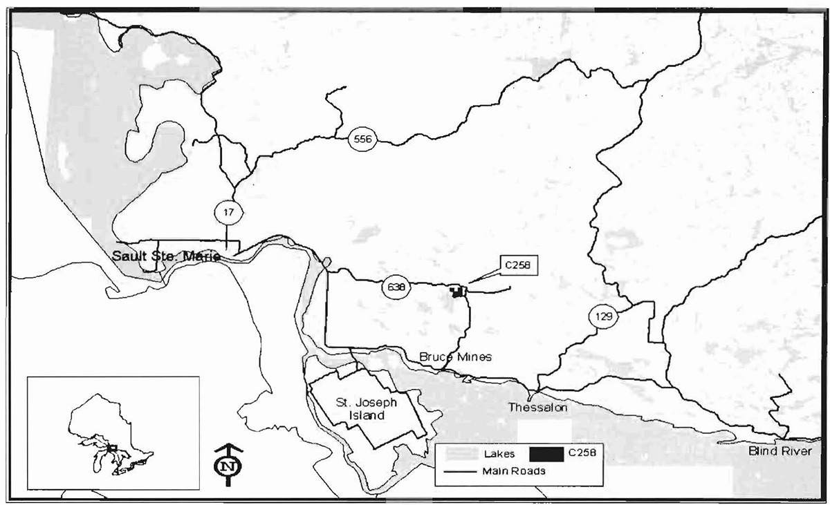
10.1 Map 1: Location of Thessalon River Delta/Rock Lake Red Oak (C258)
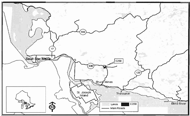
Enlarge map 1: Location of Thessalon River Delta/Rock Lake Red Oak (C258)
10.2 Map 2: Values for Thessalon River Delta/Rock Lake Red Oak
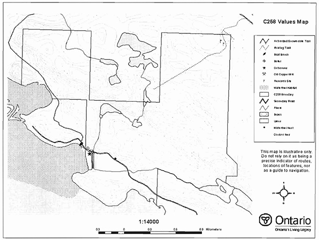
Enlarge map 2: Values for Thessalon River Delta/Rock Lake Red Oak
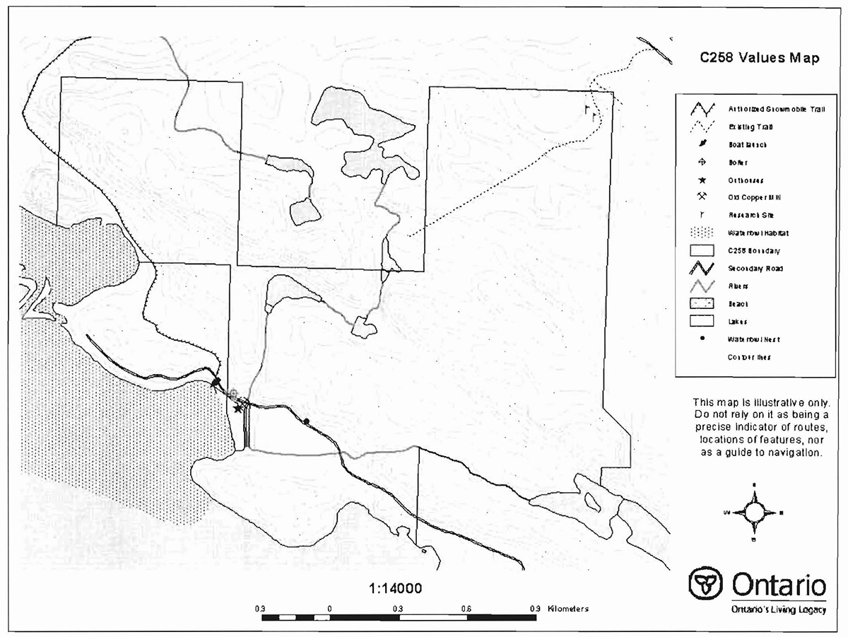
10.3 Map 3: Location of Significant Values - C258
Enlarge map 3: Location of Significant Values - C258
11.0 Photos
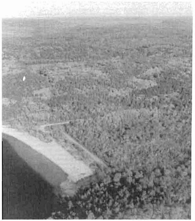
Southern extent of conservation reserve on Rock Lake, looking North
Taken by Sheila Walsh, October 2000.
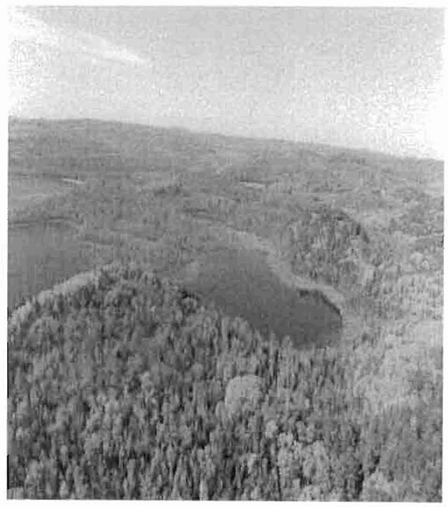
Indian Lake, near mouth of Thessalon River at western extent of Conservation Reserve
Taken by Sheila Walsh, October 2000.
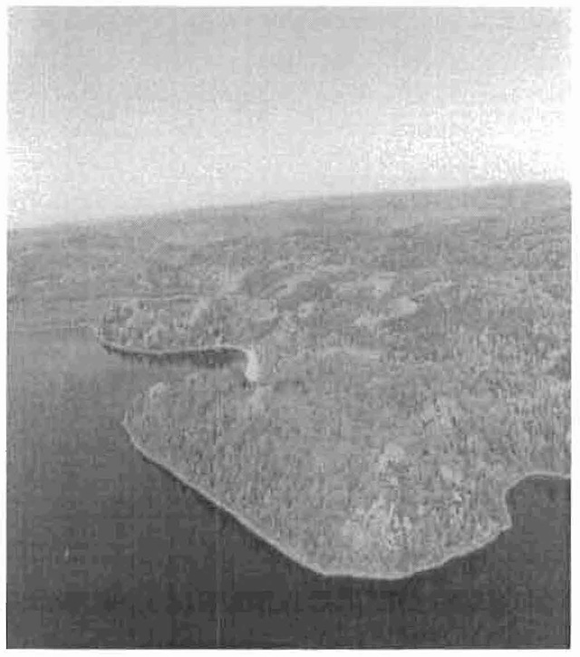
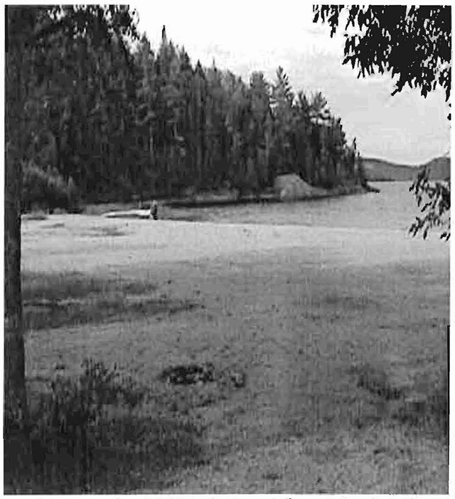
"Old Mill Beach" on Rock Lake, looking north (northeast)
Taken by Sheila Walsh, October 2000.
Looking at the "Old Mill Beach" and Rock Lake.
Taken by Mark Austin, 2001.
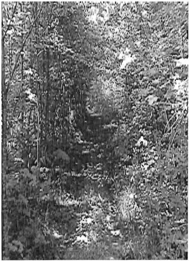
Section of the Ontario Federation Snowmobile Club trail as identified in section 5.2.1.4.
Taken by Mark Austin, 2001.
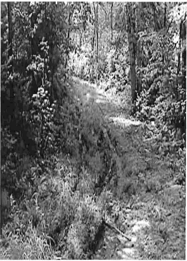
Section of the Ontario Federation Snowmobile Club trail as identified in section 5.2.1.4.
Taken by Mark Austin, 2001
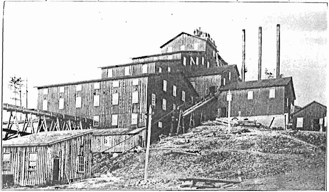
Rock Lake copper mine; Concentrating plant
Mines Library, Sudbury, Ontario, 1898
Appendices
Appendix A: SCI Test of Compatibility
Test of Compatibility :footnote 3 :
-
Conformity to SCI/RMP: SCI describe values for which an area has been set aside and the range of appropriate uses that will be permitted in the area. SCI may also speak to the acceptability of other 'new' uses currently not occurring in the area.
The first 'test' is: "do proposed new land uses and/or commercial activities conform to the direction of the SCI/RMP for the conservation reserve? Would the new use(s) depart from the spirit of appropriate indicator land uses in the SCI/RMP?"
-
Screening Process - proposed uses for the area must be assessed before they are approved. To establish a minimum standard, Northeast Region (NER) recommends that the Screening Process identified in Section 4.2 of A Class EA for Provincial Parks and Conservation Reserves Phase lib: Draft Class EA (subject to approval by MOE) be used to screen projects and options.
-
Impact Assessment - the Test of Compatibility from the Conservation Reserve Policy (PL 3.03.05) identifies the classes of values and main concepts that need to be considered in determining the impacts of uses on a specific Conservation Reserve. These include:
- Natural heritage
- Cultural
- Research activities
- Current uses
- Area administration
- Accommodating the use outside the conservation reserve
- Socio-economics
- Area accessibility
The class EA (Table 4.1) presents similar values and concepts under the following considerations::
- Natural environment
- Land use, resource management
- Social, cultural and economic
- Aboriginal
The above considerations and classes of values are meant to assist planning staff in answering the following questions for any potential use:
- Will the new use impact any values within the Conservation Reserve?
- If so how?
- To what degree?
- Is it tolerable?
Appendix B: Summary of Permitted Uses
Crown Land Use Atlas - Policy Report
C258
Thessalon River Delta/Rock Lake Red Oak
Updated: September 25, 2002
Identification:
ID: C2S8
Area name: Thessalon River Delta/Rock Lake Red Oak
Area (ha): 295
Designation: Conservation Reserve (Ontario’s Living Legacy)
District(s): Sault Ste. Marie
Description:
This area includes a river delta covered in open bog and fen habitats, and also includes rare plants and combinations of vegetation and landforms unique in Site District 5E-1. There are typical floodplain features such as oxbow lakes, backwater swamps and lagoons. Upland forests include sugar maple, red maple and eastern white cedar and are connected to red oak forests northwest of Rock Lake.
Thessalon River Delta /Rock Lake Red Oak was regulated as a conservation reserve on April 6, 2001.
Land use intent:
Statement of Conservation Interest to recognize existence of open mine shafts on site.
Management of this area is also governed by the general policies contained in the Land Use Strategy (1999).
Management direction:
Those uses and management activities not listed in the following table are governed by existing conservation reserve policy. Over time the management direction will be elaborated in a Statement of Conservation Interest or Resource Management Plan. Any new uses, and commercial activities associated with conservation reserves, Will be considered on a case by case basis, and they must pass a test of compatibility to be acceptable. Compatibility is normally determined through a planning process.
Commercial activities
| Activity | Permitted | Guidelines |
|---|---|---|
| Aggregate Extraction | No | |
| Bait Fishing - Existing: | Yes | Existing use permitted to continue, unless there are significant demonstrated conflicts. |
| Bait Fishing - New: | Maybe | New operations can be considered, subject to the "test of compatibility". |
| Commercial Fishing - Existing: | Yes | Existing use permitted to continue, unless there are significant demonstrated conflicts. |
| Commercial Fishing - New | Maybe | New operations can be considered, subject to the "test of compatibility". |
| Commercial Fur Harvesting - Existing: | Yes | Existing use permitted to continue, unless there are significant demonstrated conflicts. |
| Commercial Fur Harvesting - New: | Maybe | Existing trap cabins can continue. New cabins are not permitted. New operations can be considered, subject to the "test of compatibility". |
| Commercial Hydro Development | No | |
| Commercial Timber Harvest | No | |
| Commercial Tourism - Existing: | Yes | Existing authorized facilities can continue, unless there are significant demonstrated conflicts. |
| Commercial Tourism - New: | Maybe | New tourism facilities can be considered during the planning for an individual reserve. |
| Beer Hunting by Non-residents (guided) - Existing: | Yes | Existing authorized operations permitted to continue. |
| Beer Hunting by Non-residents (guided) - New: | No | New operations not permitted. |
| Outfitting Services - Existing: | Yes | Existing authorized operations permitted to continue. |
| Outfitting Services - New: | Maybe | New operations can be considered during the planning for an individual reserve. |
| Outpost camps - Existing: | Yes | Existing authorized operations permitted to continue. |
| Outpost camps - New: | Maybe | New operations can be considered during the planning for an individual reserve. |
| Resorts/lodges - Existing: | Existing authorized facilities permitted to continue. | |
| Resorts/lodges - New: | New facilities can be considered during the planning for an individual reserve. | |
| Energy Transmission and Communications Corridors - Existing: | Yes | These facilities should avoid conservation reserve lands whenever possible. |
| Energy Transmission and Communications Corridors - New: | New | These facilities should avoid conservation reserve lands whenever possible. |
| Food Harvesting (Commercial) - Existing: | Maybe | |
| Food Harvesting (Commercial) - New: | Maybe | |
| Mineral Exploration and Development | No | |
| Peat Extraction | No | |
| Wild Rice Harvesting - Existing | Yes | |
| Wild Rice Harvesting - New | Maybe |
Land and resource management activities
| Activity | Permitted | Guidelines |
|---|---|---|
| Crown Land Disposition - Private Use: | Maybe | Sale of lands is not permitted, except for minor dispositions in support of existing uses (e.g. reconstruction of septic system). Renewals of existing leases and land use permits are permitted. Requests for transfer of tenure will be considered in the context of the Statement of Conservation Interest or Resource Management Plan. New leases or land use permits permitted for approved activities. Tourism facilities can apply to upgrade tenure from. |
| Crown Land Disposition - Commercial Use: | Maybe | Sale of lands is not permitted, except for minor dispositions in support of existing uses (e.g. reconstruction of septic system). Renewals of existing leases and land use permits are permitted. Requests for transfer of tenure will be considered in the context of the Statement of Conservation Interest or Resource Management Plan. New leases or land use permits permitted for approved activities. Tourism facilities can apply to upgrade tenure from. |
| Fire Suppression | Yes | Fire suppression policies are similar to adjacent Crown lands, unless alternative tire policies have been developed through a planning process. |
| Fish Habitat Management | Maybe | |
| Fish Stocking | Maybe | Conservation Reserves policy indicates that "featured species management" may be permitted. |
| Insect/disease suppression | Maybe | |
| Inventory/Monitoring | Yes | |
| Prescribed Burning | Maybe | |
| Roads (Resource Access) - Existing: | Yes | Existing roads can continue to be used. Continued use will include maintenance and may include future upgrading. |
| Roads (Resource Access) - New: | Maybe | New roads for resource extraction win not be permitted, with the exception of necessary access to existing forest reserves for mineral exploration and development. |
| Vegetation Management | Maybe | Conservation Reserves policy indicates that Featured Species Management and Natural Systems Management may be permitted. Vegetation management can be cons1dered in a planning process. |
| Wildlife Population Management | Maybe |
Science, education and heritage appreciation
| Activity | Permitted | Guidelines |
|---|---|---|
| Collecting | No | |
| Historical Appreciation | Yes | |
| Nature Appreciation | Yes | |
| Photography and painting | Yes | |
| Research | Yes | |
| Wildlife Viewing | Yes |
Recreation activities and facilities
| Activity | Permitted | Guidelines |
|---|---|---|
| All-terrain vehicle use - On trails: | Yes | Existing use permitted to continue where it does not adversely affect the values being protected. |
| All-terrain vehicle use - Off trails: | No | ATV use off trails is not permitted except for direct retrieval of game. |
| Campgrounds | Maybe | |
| Food Gathering | Yes | |
| Horseback Riding (trail) | yes | Existing use on trails permitted. |
| Hunting | Yes | |
| Mountain Bike Use | Yes | Yes existing use on trails permitted. |
| Motor Bot Use - Commercial: | Yes | |
| Motor Bot Use - Private: | Yes | |
| Non-motorized Recreation Travel | Yes | |
| Private Recreation Camps (Hunt camps) - Existing: | Yes | Existing camps permitted to continue, and may be eligible for enhanced tenure, but not purchase of land. |
| Private Recreation Camps (Hunt camps) - New: | No | |
| Rock Climbing | Maybe | |
| Snowmobiling - On Trails: | Yes | Existing use permitted to continue where it does not adversely affect the values being protected. |
| Snowmobiling - Off Trails: | Maybe | Snowmobiling off trails is not permitted, except that snowmobiles may be used for direct retrieval of game. |
| Sport Fishing | Yes | |
| Trail Development | Maybe | Development of trails for a variety of activities (e.g. hiking, cross-country skiing, cycling, horseback riding, snowmobiling) can be considered as part of planning for an individual reserve. |
Note: The policies outlined in this table do not supersede any Aboriginal or treaty lights that may exist, or other legal obligations.
Management of this conservation reserve is carried out within the context of Conservation Reserve policy as amended by the policies for raw conservation reserves outlined in the Ontario’s Living Legacy Land Use Strategy.
Source of direction:
Ontario’s Living Legacy Land Use Strategy (1999)
Conservation Reserves Policy (1997)
Sault Ste. Marie District Land Use Guidelines (1983)
Explanation of edits:
Appendix C: Public consultation handouts
September 1, 2000
To: Ontario Living Legacy Stakeholders
Dear Sir/Madam:
On July 16, 1999, the Ontario Government released the Ontario’s Living Legacy Land Use Strategy, a broad land use approach to the planning and management of much of the Crown lands in central and parts of northern Ontario. A major part of the Ontario’s Living Legacy Land Use Strategy was a government commitment to the biggest expansion of provincial parks and conservation reserves in Ontario’s history. Ontario intends to add 378 new areas to its protected areas system. Ontario’s Living Legacy is a momentous achievement that will be recognized around the world as a significant contribution to sustaining our natural environment. A copy of the Land Use Strategy is available from our office upon request.
In accordance with the recommendations in the Land Use Strategy, the Ministry of Natural Resources is now implementing the process of establishing these 378 new protected areas. The first step in this process is for the Ministry to consult on the boundaries of these areas. In November 1999, MNR held boundary consultations on 64 sites across the OLL Planning Area. Eight of these sites were within Sault Ste. Marie District. At this time, Sault Ste. Marie District has prepared 19 more sites for boundary refinement consultation. Adjacent Districts are consulting an additional two sites, which are also partially contained within Sault Ste. Marie District, on. In future years, the remaining recommended protected areas from the Land Use Strategy will be put forward for similar consultations.
As stated in the Land Use Strategy, the boundary refinement process will consider local ecological information and will attempt to establish regulated boundaries along features that can be identified on the ground. The boundary refinement process may result in modest increases or decreases in the sizes of the protected areas. Any existing commitments for the areas, which were considered during the land use planning process, will be considered in defining the final boundary.
Following is a list of the 21 sites in SSM District scheduled for boundary consultation this year. These sites include both provincial parks and conservation reserves. The Land Use Strategy established the Ministry’s intent to add these Crown lands to Ontario’s protected areas system, following the extensive public consultation associated with Ontario’s Living Legacy and the Lands for Life land use planning initiatives between 1997 and 1999. The Ministry is inviting public comment on the proposed boundaries of these protected areas prior to their finalization and ultimate regulation under the Provincial Parks Act or the Public Lands Act.
- C227 - Glen Crombie Conservation Reserve
- P238- Mississagi River Provincial Park Additions
- C243 - Wagong Lake Forest Conservation Reserve
- C244 - Rawhide Lake Conservation Reserve
- C246 - Echo River Hardwoods Conservation Reserve
- C247 - Byrnes Lake White Birch Conservation Reserve
- P253- Goulais River Provincial Park
- C256 - Basswood Lake Hemlock Conservation Reserve
- C258 - Thessalon River Delta I Rock Lake Red Oak Conservation Reserve
- C260 - Rose Lake Dune Peatland Complex Conservation Reserve
- C262 - Stuart Lake Wetland Conservation Reserve
- P273 - Algoma Headwaters Provincial Park
- P274 - Wenebegon River Provincial Park
- P277 - Aubinadong - Nushatogaini Rivers Provincial Park
- P278 - Pancake Bay Provincial Park Additions
- P282 - Batchawana River Provincial Park
- P285 - Sandy Islands Provincial Nature Reserve
- C289 - Searchmont South Forest Conservation Reserve
- C291 - Goulais River Beach Ridges Conservation Reserve
- P292 - Lake Superior Provincial Park Additions
- C307 - Ile Parisienne Conservation Reserve
Your name and address have been included within a Ministry mailing list of persons potentially interested in these boundary consultations. The mailing list includes a range of individuals and groups, such as nearby landowners, resource users, persons with other rights or tenure (e.g. land use permit, Mining Act rights), municipalities, and others who may have an interest in the area. Accompanying this letter, you will find background information (factsheets, maps) for the site(s) we have determined to be of interest to you. More detailed maps and information about the proposed boundaries for all 21 sites are available from this office, or from the Blind River Area Office, 62 Queen Ave., Blind River.
In the future and subject to the intended regulation of these areas as provincial parks and conservation reserves, Ontario Parks and the Ministry of Natural Resources will undertake a management planning process to determine the long-term management of these protected areas. Depending upon the complexity of issues related to the provincial parks, management planning may take the form of a simple Interim Management Statement or a more detailed Park Management Plan. In the case of planning for conservation reserves, a simple Statement of Conservation Interest or a more detailed Resource Management Plan will result. Please let us know if you would like to be notified when planning begins.
Planning, management and permitted uses within these provincial parks and conservation reserves would be consistent with the commitments of the Ontario’s Living Legacy Land Use Strategy.
The Ministry is collecting comments and information regarding these proposed provincial park and conservation reserve boundary reviews under the authority of the Provincial Parks Act and the Public Lands Act respectively. These comments will assist the Ministry in making decisions and determining further public consultation needs. Comments and opinions will be kept on file and may be included in study documentation that is made available for public review. Under the Freedom of Information and Protection of Privacy Act (1987), personal information will remain confidential unless prior consent is obtained. However, the Ministry may use this information as public input on other resource management surveys or projects. For further information regarding this Act, please contact Paul Glassford, A/Information Management Supervisor, Ministry of Natural Resources, Sault Ste. Marie District (705-949-1231).
If you would like to discuss the proposed boundaries and the protection of these areas under the Provincial Parks Act and/or the Public Lands Act, please contact Erin Nixon, District Planner, Ministry of Natural Resources, 64 Church Street, Sault Ste. Marie, Ontario, P6A 3H3; telephone (705) 949-1231 ext. 247, fax (705) 949-6450, by October 6, 2000. Further information on Ontario’s Living Legacy is available in our office or by visiting the Ministry’s internet website at /page/ministry-natural-resources-and-forestry.
Thank you for your interest. Yours sincerely,
Dick Hagman
A/District Manager
Sault Ste. Marie District
DH/sw
Attachments:
Provincial Park and/or Conservation Reserve Factsheet(s)
Proposed Site Boundary Map(s)
Key Map
Permitted Uses Table(s) for Provincial Parks and/or Conservation Reserves
On peut obtenir la version française de la présente lettre en s'adressant au bureau du MRN le plus proche, à l'adresse ou au numéro de téléphone ci-dessous.
Ontario’s Living Legacy
Thessalon River Delta /Rock Lake Red Oak
Conservation Reserve (C258) Fact Sheet
September 2000
Background
On July 16, 1999, the Ontario Government released the Ontario’s Living Legacy Land Use Strategy to guide the planning and management of Crown lands in central and parts of northern Ontario. A major part of the Ontario’s Living Legacy Land Use Strategy was a government intent to establish 378 new protected areas. This commitment marks the biggest expansion of provincial parks and conservation reserves in Ontario’s history.
The proposed Thessalon River Delta I Rock Lake Red Oak Conservation Reserve is part of this significant expansion of Ontario’s protected areas system.
Size and location
The Thessalon River Delta I Rock Lake Red Oak Conservation Reserve is located along the north shore of Rock Lake, approximately 20 km north of the town of Bruce Mines. The conservation reserve encompasses 295 ha of forested and non-forested land in Aberdeen Township. It protects an area that is recommended as provincially significant.
Area highlights
The Thessalon River Delta I Rock Lake Red Oak Conservation Reserve is located within ecological site district 5E-1, a 25-km deep band of land extending from Sault Ste. Marie to Spanish along the St. Mary’s River and Lake Huron shoreline. This site district is characterized along the coast by lacustrine plains interrupted by small bedrock knolls, and inland by bedrock controlled, till-covered uplands. Natural vegetation communities that develop within this area combine species from both the Great Lakes I St. Lawrence and Boreal forest regions.
This conservation reserve includes the Thessalon River Delta, formed where the river enters the north end of Rock Lake. Typical flood plain features such as oxbow lakes, backwater swamps, lagoons and levees occur on the eastern side of the river and are interspersed with upland forests and rock outcrops. Geologically, the delta formation and associated flood plain and alluvial features create rich conditions that support rare and unusual wetland communities. The rocky uplands support red oak dominated forests, an uncommon species in this area occurring at the northern limit of its range. Sugar maple, red maple, and eastern white cedar are also present.
Patent lands, including areas of private agricultural land, abut the boundary of this conservation reserve.
Land use intent
Conservation reserves are areas of Crown land set aside by regulation under the Public Lands Act.
Conservation reserves complement provincial parks in protecting representative natural areas and special landscapes. Most recreational (e.g. hiking, skiing, tourism related uses, nature appreciation) and non-industrial (e.g. fur harvesting, commercial fishing and bait harvesting) activities that have traditionally been enjoyed in the area will continue, provided that these uses do not impact on the natural features needing protection. Hunting and fishing are also permitted within all new conservation reserves recommended through Ontario’s Living Legacy.
Commercial timber harvesting, mining, aggregate extraction and commercial hydroelectric development are prohibited in conservation reserves. Careful mineral exploration may occur in specific new conservation reserves proposed through Ontario’s Living Legacy, in areas that have provincially significant mineral potential. If a portion of a new conservation reserve is to be developed for a mine, it would be removed from the reserve, and appropriate replacement lands would be placed in regulation. Please refer to Table 4 from the Land Use Strategy for a detailed summary of permitted uses in conservation reserves.
Next steps
The Land Use Strategy established the Ministry’s intent to add these Crown lands to Ontario’s protected areas system, following the extensive public consultation associated with the Ontario’s Living Legacy and Lands for Life land use planning initiatives between 1997 and 1999. Prior to the finalization of the boundary of this conservation reserve proposed for regulation under the Public Lands Act, the Ministry is inviting public comment on the proposed boundary from all potentially affected stakeholders and First Nations from September 6 to October 6, 2000.
In the interim, the area has been withdrawn and protected from resource extraction activities such as timber harvesting, hydroelectric development, aggregate extraction and new mineral exploration.
In the future and subject to the intended regulation of the area as a conservation reserve, the Ministry of Natural Resources will prepare a long term management plan for this area. Depending upon the complexity of issues within this conservation reserve, management planning may take the form of a simple Statement of Conservation Interest or a more detailed Resource Management Plan. Please let us know if you would like to be notified when planning begins.
Planning, management and the uses permitted within this conservation reserve will be consistent with the commitments of the Ontario’s Living Legacy Land Use Strategy.
For more information
For further information on the proposed Thessalon River Delta I Rock Lake Red Oak Conservation Reserve, please contact Erin Nixon, District Planner, Ministry of Natural Resources, Sault Ste. Marie District (705-949-1231ext. 247). You may also visit the Ministry’s internet website at www.ontarioslivinglegacy.com [Link to longer works] for information about Ontario’s Living Legacy.
August 22, 2001
Regulation of Ontario’s Living Legacy Protected Areas in Sault Ste. Marie District
In July 1999, the Ontario Government released the Ontario’s Living Legacy Land Use Strategy, a broad land use approach to the planning and management of Crown lands in central and parts of northern Ontario. A large component of the Ontario’s Living Legacy Land Use Strategy was a government commitment to add 378 new provincial parks and conservation reserves to Ontario’s protected areas system.
In November 1999 and again in September 2000, we provided you with the opportunity to comment on the proposed boundaries for the park and the conservation reserves in Sault Ste. Marie District. I am pleased to inform you that, as of January 2001, the ·park and fifteen of these conservation reserves have been regulated. The new park and conservation reserves in the District are:
- P285 Sandy Islands Provincial Nature Reserve
- C243 Wagong Lake Forest Conservation Reserve
- C244 Rawhide Lake Conservation Reserve
- C245 Jollineau Conservation Reserve Conservation Reserve
- C246 Echo River Hardwoods Conservation Reserve
- C258 Thessalon River Delta/Rock Lake Red Oak Conservation Reserve
- C260 Rose Lake Dune Peat/and Complex Conservation Reserve
- C262 Stuart Lake Wetland Conservation Reserve
- C263 Garden Lake Forest Conservation Reserve
- C281Tilley Creek West Conservation Reserve
- C284 Wabos North Conservation Reserve
- C286 Wabos South Conservation Reserve
- C289 Searchmont South Forest Conservation Reserve
- C294 O'Connor Conservation Reserve
- C298 Harmony Forest Conservation Reserve
- C307 Ile Parisienne Conservation Reserve
Regulation means the park and conservation reserves are now legally mapped and recognized as protected areas of crown land under the jurisdiction of the provincial government. As such, these areas will be protected from industrial activities, including commercial forestry, hydroelectric development, mining, and aggregate and peat extraction. Traditional recreational and resource uses such as hunting, fishing, hiking, canoeing, boating, and fur trapping, will generally be permitted to continue within the conservation reserves. In nature reserve class provincial parks (e.g. P285, Sandy Islands), hunting and fur trapping are not permitted; other traditional recreational uses (fishing, hiking, canoeing, boating) may continue.
Ontario Parks staff is responsible for the planning and management of Sandy Islands Provincial Nature Reserve and they will prepare an Interim Management Statement to guide the management of this property. Sault Ste. Marie District is responsible for the management of the conservation reserves and will develop Statements of Conservation Interest (SCI) to guide the management of each new conservation reserve. There will be opportunity for the public to review and comment on draft SCI's for each conservation reserve. Depending upon the complexity of issues related to the sites and their management, more detailed Management Plans may, in due course, may be required.
Detailed maps of the regulated boundaries for these new protected areas are available for viewing in the Sault Ste. Marie District office and the Blind River Area office of the Ministry of Natural Resources.
If you have any questions or concerns about the management of Sandy Islands Provincial Nature Reserve, please contact Chris Caldwell, Ontario Parks at the Sault Ste. Marie District Office. Concerns regarding any of the conservation reserves should be addressed to Sheila Walsh (OLL Resource Planner) also at the Sault Ste. Marie District Office.
Thank you for your interest in Ontario’s Living Legacy.
Yours truly,
Tom Mispel-Beyer
A/District Manager
Sault Ste. Marie District
Telephone: 705-949-1231
Facsimile: 705-949-6450
E-mail: tom.mispelbeyer@mnr.gov.on.ca
TMB/gm
Footnotes
- footnote[1] Back to paragraph Noble (1993) and Bergsma (1998) classified Thessalon River Delta as a provincially significant area adjoining the Rock Lake Red Oak area to the delta site (Bergsma 1998). During the Ontario’s Living Legacy process, it was Ontario Parks' goal to include the delta within the conservation reserve; however, the entire delta is under mining patents and is not available for protection. Thus, while the site’s name refers to both the delta and the red oak communities, only the red oak communities are currently protected within this conservation reserve.
- footnote[2] Back to paragraph Proterozoic relates to the later part of the Precambrian Era, characterized by the oldest forms of life.
- footnote[3] Back to paragraph This Test of Compatibly is taken from both Procedural Guidelines 8- Land Uses-Test of Compatibility PL 3.03.05 and from the Planning Process for Conservation Reserve Statement of Conservation Interest and Resource Management Plan Northeast Region Guidelines Version 2.1 September 17, 2001.