Tidewater Provincial Park Management Plan
This document provides policy direction for the protection, development and management of Tidewater Provincial Park and its resources.
Approval statement
Tidewater Provincial Park is among the northernmost in the provincial system, yet it can be accessed with relative ease by air or by rail. Situated on five islands near the mouth of the Moose River, between Moosonee and Moose Factory, the park and surrounding area are rich in both natural and cultural resources, affording visitors the opportunity to experience a small sample of the environment of the James Bay Lowland.
We are pleased to approve the Tidewater Provincial Park Management Plan as the official policy for the management and development of the park. The plan reflects this Ministry’s intent to protect the park’s natural and cultural features, and to maintain high quality outdoor recreation and heritage appreciation opportunities for both residents of Ontario and visitors to the Province.
Signed by:
R.A. Riley
Regional Director
Northern Region
Signed by:
N.R. Richards
Director
Parks Recreational Areas Branch
ISBN 0-7729-0184-8
1986 Government of Ontario
1.0 Introduction
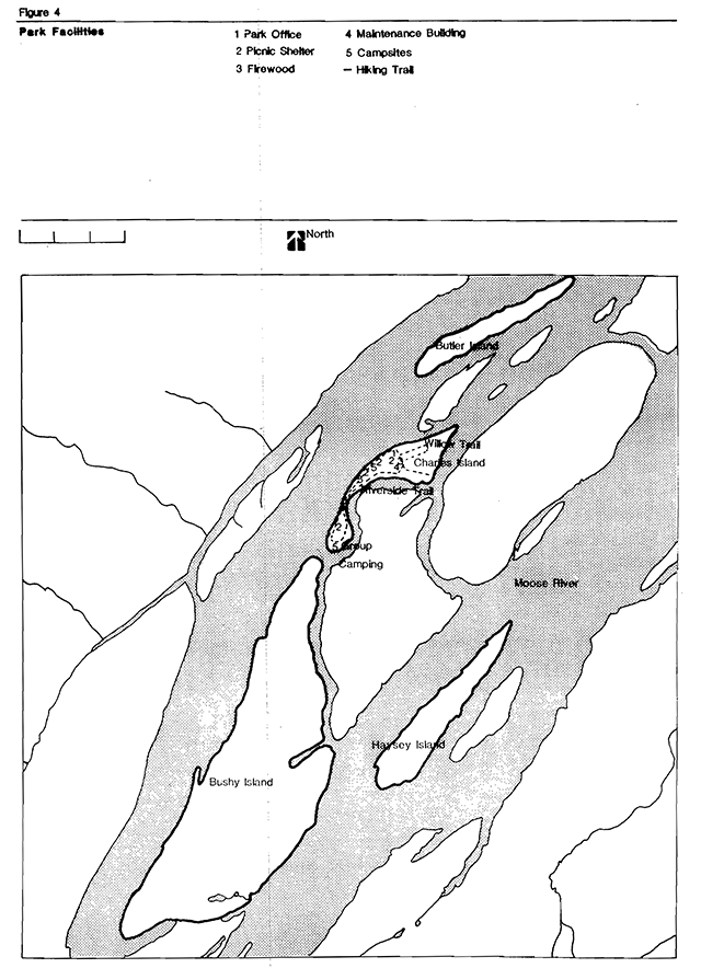
Tidewater Provincial Park is located twenty kilometres from the mouth of the Moose River, in the Ministry of Natural Resources’ Moosonee District (Figures 1 and 2). The park consists of sections of five islands which lie between the communities of Moosonee and Moose Factory (Figure 3). Of the five islands, only North Charles is developed. The others (Bushy, Butler, South Charles and Haysey) were included in the park to protect natural values. The development of North Charles island began in the mid 1960s, and the park was established in regulation in 1970.
The landscape of this 980 hectare park is characteristic of the Hudson and James Bay Lowlands, one of the largest flat areas on earth. The park islands are underlain by rocks of the Middle Devonian era, capped by glacial debris, marine clay, and rich alluvial soil. The estuarine tides of the Moose River exert a considerable influence on the park environment. Vegetation is essentially a floodplain forest, with a variety of maritime and subarctic/arctic vascular plants.
The park offers camping (30 sites) and day-use facilities (shelters, tables, grills) to a clientele which includes local residents, canoeists, and travellers on the Polar Bear Express excursion train, which originates in Cochrane 300 kms to the south.
More detailed resource information is available in the Tidewater Provincial Park Background Information report, available on request from the Moosonee District Office.
2.0 Park policies
2.1 Park classification
Tidewater Provincial Park is classified as a natural environment park, in recognition of the its significant geomorphological and botanical features, and of its capacity to support a variety of outdoor recreation activities.
2.2 Park goal
To provide opportunities for outdoor recreation and educational experiences for park visitors within a high quality natural setting which is representative of the James Bay Lowland.
2.3 Park objectives
Tidewater will contribute to the four objectives of the Ontario Provincial Parks system (Provincial Parks Policy, 1978).
2.3.1 Protection
To protect provincially significant elements of the natural and cultural landscape of Ontario.
Tidewater contains elements of two provincially significant landscape units (riparian polar forest, intertidal marshes), ten provincially significant vascular plant species, and examples of estuarine and tidal processes that are rare in the park system.
2.3.2 Recreation
To provide outdoor recreation opportunities ranging from high intensity day-use to low intensity camping.
The park, at optimum levels, can provide 4,475 camping and 4,825 day-use opportunities annually. As the terminus of several major canoe routes, and given its proximity to James Bay, the park also has the potential to act as a base of operations for canoeists exploring the general area around Moosonee/Moose Factory. It should be noted that hazardous wind and tide conditions occur, and such exploration should be approached with caution.
2.3.3 Tourism
To provide Ontario’s residents and out-of-province visitors with opportunities to discover and experience one of the distinctive regions of the province.
Given its proximity to Moosonee, Tidewater lies in the only portion of the Hudson/James Bay Lowlands that is easily (and economically) accessible to tourists.
2.3.4 Heritage appreciation
To provide opportunities for exploration and appreciation of the outdoor natural and cultural heritage of Ontario.
The Moosonee/Moose Factory area is steeped in history, being one of the major centers for the early fur trading industry. Located on Ontario’s only saltwater coast, and located in the far north, it is an excellent location to observe unusual plants, migrating birds, etc.
2.4 Zoning
Of the six zone designations possible in a natural environment class park, three are utilized at Tidewater. They are:
2.4.1 Nature Reserve
- NR1 - Cedar Stand
- A relatively pure stand on the west side of South Charles Island, this site is one of the northernmost accessible examples of this feature.
- NR2 - Butler Island marshes
- An intertidal, freshwater marsh which is significant in itself, and which contains a variety of provincially significant plant species.
- NR3 - Bushy Island
- An extensive Lowland thicket habitat, representative of the vegetation common to the Moose River estuary.
- NR4 - Haysey Island
- A representative example of riparian forest vegetation, and of upland mixed intolerant forest, along with several regionally and provincially uncommon vascular plants.
2.4.2 Natural environment
- NR1 - Butler Island
- Excellent representation of lowland thicket habitat typical of the Moose River estuary.
2.4.3 Development
- D1 - North Charles Island
- This zone contains the current camping and day-use facilities, and is the focus of activity for visitors to the park.
- D2 - South Charles Island
- This zone contains a Junior Ranger Camp at the south end of the island.
3.0 Resource management policies
The park will be managed in accordance with the general planning and management policies for natural environment class parks (Ontario Provincial Parks - Planning and Management Policies - 1978). Specific direction, where required to meet requirements particular to Tidewater, is provided below.
Although the policies are presented in separate categories, all planning and management will recognize that the components of the plan are inter-related, and that an integrated approach will be required in order for the park to achieve its stated objectives.
3.1 Vegetation
Vegetation in the park will be managed to fulfill the protection and recreation objectives. The removal of hazard trees in the development zone is permitted only where they pose a threat to human safety or property. Provincially significant features will be subject to protective zoning.
Aerial spraying for the release of vegetation is prohibited. Spraying of chemicals and pathogens will not be permitted unless the park is seriously threatened by insects or disease. All spray programs will be carried out in accordance with guidelines established by the Ministries of Natural Resources and the Environment, and will only occur in the park’s development zones.
Berry picking and limited personal consumption of edible wild plants other than those found in the nature reserve zones will be permitted.
3.2 Wildlife
Hunting and trapping are not permitted in the park, except as provided for by native treaty rights.
3.3 Landforms
The park is often subject to serious flooding and coincidental ice damage during the spring breakup. Combined with the considerable effects of tides and currents, the result has been severe bank undercutting and erosion, particularly on the south end of North Charles Island where park development is concentrated.
Breakwater reinforcements similar to the ones used to stabilize the south end of adjacent Moose Factory Island will be installed if funding permits. In the interim, relocation of the group camping area, some individual campsites, and internal trails will occur as required. Any major relocation/redevelopment will require an approved site plan as will the installation of a breakwater.
3.4 Hydrology
Due to the flooding and ice damage referenced above, and deep frost penetration, the use of vault privies has not been successful at Tidewater. Earth pit toilets have replaced them. Those toilets are located above (up-strata from) the well-head that supplies the park’s drinking water. In a very dry year, the possibility exists that effluent from the toilets could infiltrate the well-head’s aquifer, although this condition hasn’t occurred to date. Early evidence of this will be provided by the daily monitoring of water quality according to standard procedures. Should it occur, the park’s water system would be shut down until the condition is corrected.
3.5 Lands
North Charles Island is directly in line with the most practical winter crossing route between Moosonee and Moose Factory. A letter of agreement regarding the location of, and standards for, the road has been signed by representatives of the Moosonee Area Development board and the Ministry. It grants permission for a temporary winter road across North Charles Island. The road has had a negligible impact to date, and is not viewed as a threat to the park’s resources.
3.6 Cultural resources
The original Moose Fort is reported to have been located on Haysey Island, although archaeological efforts to unearth its remains have been unsuccessful. While no development on Haysey Island is proposed, a detailed study of the site should be undertaken to ascertain if, and where, the remnants of the fort site are located.
4.0 Park operations
4.1 Visitor services
The park has two major visitor services themes: a) the Northern Access Rail Route, which deals with the Temiskaming and Northern Ontario Railway’s effect upon the business and social life of the early settlers in the Moosonee/Moose Factory - personnel of The Hudson’s Bay and Revillon Freres Companies; and b) the environment of the Hudson/James Bay Lowlands. Tidewater is the only park with reasonable access where this theme can be covered. In addition, the park’s location lends itself to the interpretation of estuarine ecology.
The visitor services program at Tidewater will continue at a basic level of service, utilizing self-use media wherever possible (brochures, trail guides, etc.). Other interpretive facilities, such as the Revillon Freres Museum and the M.N.R. District Office visitor centre in Moosonee, and the Hudson Bay Museum in Moose Factory continue to provide the bulk of the visitor services facilities for the park and surrounding area.
A revised visitor services strategy, conforming to the provincial visitor services policy approved in 1986, will be prepared. It will be reviewed annually, and updated as required.
4.1.1 Information
The information function at Tidewater will be fulfilled by park staff, particularly the Superintendent, and by park publications and exhibits such as the one at the district office. Through them, park users will be informed about the park’s natural features, facilities, programs and points of interest in the surrounding area.
4.1.2 Recreation
The aim of the outdoor recreation component of the visitor services program will be to provide the best information possible regarding the local area’s recreational opportunities, special events, and so forth. These include camping, picnicking, boating, fishing, canoeing, hiking, and other related outdoor activities.
4.1.3 Interpretation
Tidewater Provincial Park will encourage groups or individuals to use the park’s resources for outdoor education purposes which are non-destructive and compatible with park policy and protection guidelines. Information about the park’s resources will be made available to groups interested in outdoor education. However, the emphasis for interpretation will continue to be self-use facilities, as visitation does not warrant full-time visitor services staffing.
4.2 Marketing
The park’s existing marketing plan identifies a variety of mechanisms aimed at promoting both resident and non-resident use of Tidewater. The park’s clientele consists of three basic user groups: local residents, canoeists, and travellers on the Polar Bear Express.
A new marketing strategy, conforming to the policy approved in 1986, will be prepared. Marketing initiatives will continue to be aimed at the three user groups noted above, and will be included in the park’s annual work plan where program funding is required. Given the relatively small local population, the thrust of marketing programs for Tidewater will be aimed at non-residents, and achieved through regional and provincial programs. The marketing strategy will be reviewed annually, and updated as required.
4.3 General
A park Operations Strategy will provide park staff with the necessary information required to operate the park on a day-to-day basis, and will include such topics as budget, maintenance schedules, security/enforcement, and emergency services. The provisions of the strategy will be consistent with the approved Ontario Provincial Parks Operating Standards, and it will be reviewed annually, and updated as required.
5.0 Development
No expansion of the facilities at Tidewater is anticipated. Upgrading of existing facilities such as docks, breakwater structures, picnic shelters, etc. will take place as required, subject to availability of funding.
6.0 Summary of public consultation
Given the lack of contentious issues, and the low level of development at Tidewater, the planning program was viewed as a low-key one. The Preliminary Management Plan was made available locally, and advertised in the local paper. It was also given limited distribution via a mailing list to interested groups and individuals. The public consultation program ran from June through September of 1985. The only comments received on the plan’s contents came as the result of an internal Ministry review, and they have. been incorporated into this version. No public comments were received.
7.0 Implementation strategy
The policies presented above will be implemented following the formal approval of this management plan.
This management plan will be subject to a full, scheduled review not less than once every ten years following its approval. Minor amendments to the plan may be made in the interim. Any major amendments proposed which have the potential to affect the overall policy direction of this plan will necessitate a full review.
Figure 1 - Regional setting
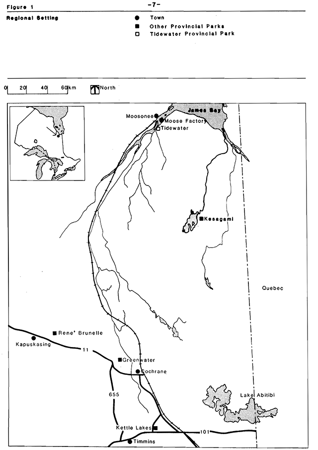
Figure 2 - Park area
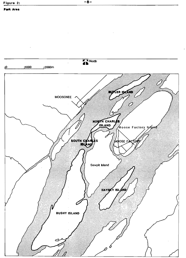
Figure 3 - Zoning
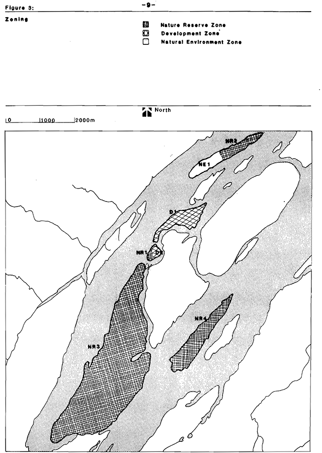
Figure 3 - Vegetation
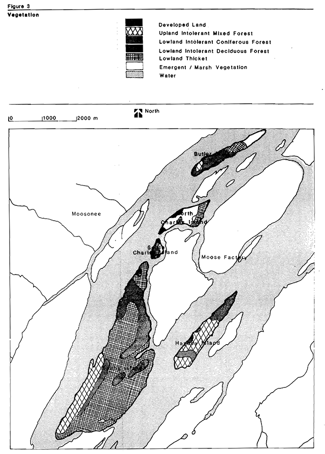
Figure 4 - Existing development
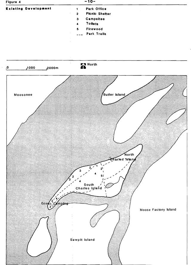
Figure 4 - Park facilities
References
Brunton, D.F., Tidewater Provincial Park Life Sciences, prepared for the Ontario Ministry of Natural Resources, Northern Region, Cochrane, 1983
Ontario Ministry of Natural Resources. Ontario Provincial Parks Policy, OMNR, Parks and Recreational Areas Branch, 1978
Ontario Ministry of Natural Resources, Ontario Provincial Parks-Planning and Management Policies, Toronto, 1978
Ontario Ministry of Natural Resources, A Topical Organization of Ontario History, Toronto, 1975
Ontario Ministry of Natural Resources, Northern Regional Parks Visitor Services Plan, Cochrane, 1978
Ontario Ministry of Natural Resources, Tidewater Provincial Park Background Information, Moosonee District, 1985 (unpublished)
University of Waterloo, An Assessment of Earth Science Processes and Features for Land Use Planning of Tidewater Provincial Park, prepared for the Ontario Ministry of Natural Resources, Northern Regional Office, Cochrane, 1982