Trollope Lake Burnt Hill Poplar Spruce Conservation Reserve Management Statement
This document provides policy direction for the protection, development and management of the Trollope Lake Burnt Hill Poplar Spruce Conservation Reserve and its resources.
November 2004
Kirkland Lake District
Ministry of Natural Resources
Approval statement
I am pleased to approve this Statement of Conservation Interest (SCI) for the Trollope Lake Burnt Hill Poplar Spruce Conservation Reserve (C1628).
Direction for establishing, planning and managing conservation reserves is defined under the Public Lands Act, the Ontario’s Living Legacy Land Use Strategy, and other applicable policies. The specific direction for managing this conservation reserve is in the form of a basic SCI, which defines the area to which the plan applies, provides the purpose for which the conservation reserve has been proposed, and outlines the Ministry of Natural Resources' management intent for the protected area. This SCI has been created with input from program specialists within Kirkland Lake District.
This SCI will provide guidance for the management of the conservation reserve and the basis for the ongoing monitoring of activities. More detailed direction at this time is not anticipated. Should significant facility development be considered or complex issues arise requiring additional studies, more defined management direction, or special protection measures, a more detailed Conservation Reserve Management Plan will be prepared with full public consultation.
Public and Aboriginal consultation occurred prior to the regulation of this conservation reserve. Furthermore, the public was notified during a 30 day period beginning October 30, 2004 concerning a draft of this SCI. Comments from the notification period have been considered in the development of this document.
The Trollope Lake Burnt Hill Poplar Spruce Conservation Reserve will be managed under the jurisdiction of the Elk Lake/Matheson Area Supervisor of the Ministry of Natural Resources, Kirkland Lake District.
Plan author:
Rick Gordon, Ontario’s Living Legacy Resource Manager
Jessy Malone, Land Use Planning Intern
Kirkland Lake District
Approved by:
Corrinne Nelson, District Manager:
Date: March 24, 2005
Approved by:
Rob Galloway, Regional Director:
Date: April 24, 2005
1.0 Introduction
Ontario’s network of natural heritage areas has been established to protect and conserve areas representative of the diversity of the natural regions of the province, including species, habitats, features and ecological systems which comprise that natural diversity. Protected natural heritage areas are a key component in sustainable management of natural resources. They ensure that representative sites within the larger sustainably managed landscape are permanently retained in their natural state.
Natural Heritage areas are considered to be sensitive, requiring protection from incompatible activities if their values are to endure over time. The Ministry of Natural Resources has established conservation reserves as a new tool to offer protection for these areas on public lands, while permitting many traditional public lands uses to continue. Such uses include the traditional activities of Aboriginal Peoples.
Ontario’s Living Legacy Land Use Strategy (OLL LUS) (MNR, 1999), and the Crown Land Use Policy Atlas set the direction for the administration and management of parks and protected areas on Crown lands within three planning regions including; the Boreal West, Boreal East and Great Lakes-St. Lawrence areas. This strategy’s natural heritage objectives include protection of natural and cultural heritage values and the provision of opportunities for outdoor recreation, heritage appreciation and tourism (MNR, 1999).
Protected areas designated within the OLL LUS have been selected based on their representation of the spectrum of the province’s ecosystems and natural features including both biological and geological features, while minimizing impacts on other land uses. Representation was described using landform and vegetation combinations based on Hill’s (1959) site district concept.
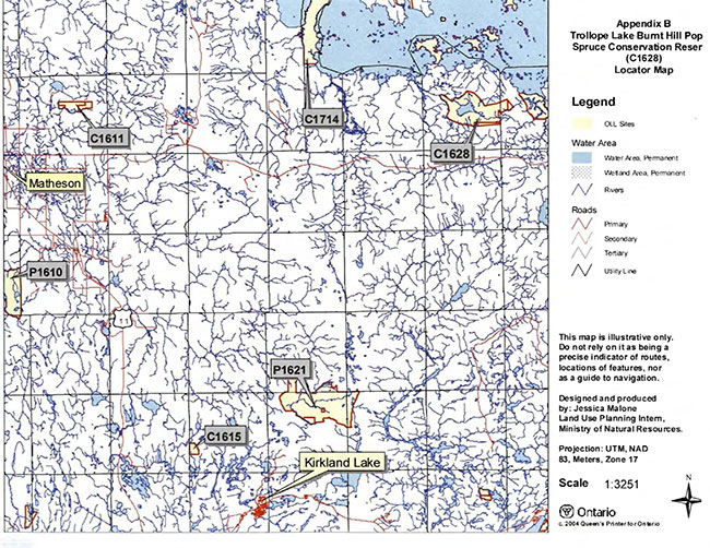
The Trollope Lake Burnt Hill Poplar Spruce Conservation Reserve is a 2,108 ha parcel of Crown land that is situated approximately 55 kilometers northeast from the Town of Kirkland Lake, 50 km east of the Town of Matheson and 10 km west of the Ontario/Quebec border. It is found within Frecheville and Stoughton Townships. These Townships are located in the Kirkland Lake District within the MNR's Northeast Region (see Locator Map within Appendix 3). The Reserve can be accessed by means of a secondary road through the site from Highway 101. The conservation reserve will be managed under a Statement of Conservation Interest (SCI).
SCI documents are the minimum level of management direction established for any conservation reserve and generally are brief management plans. This SCI will govern the lands and waters within the regulated boundary of the Trollope Lake Burnt Hill Poplar Spruce Conservation Reserve. However, to ensure MNR protection objectives are being fully met within the conservation reserve, the surrounding landscape and related activities should consider the site’s objectives and heritage values. In addition, it is the intent of the SCI to create public awareness that will promote responsible stewardship of protected areas and surrounding lands, with management partners such as Ontario Parks, industry and local governments. MNR District staff will be able to pursue and advance sound environmental, economic and social strategies and policies related to the protection of conservation reserves and provincial parks.
The purpose of this SCI is to identify and describe the values of Trollope Lake Burnt Hill Poplar Spruce Conservation Reserve and outline the Ministry’s management intent for the conservation reserve. The management direction will protect the site’s natural heritage values and demonstrate its compatibility within the larger sustainable landscape. This direction will comply with land use intent as stated by the OLL Land Use Strategy (MNR, 1999).
2.0 Goals and objectives
2.1 Goal of statement of conservation interest
The goal of this SCI is to describe and protect natural heritage values on public lands while permitting compatible land use strategies. This Statement of Conservation Interest is intended to guide the management decisions that will ensure the Trollope Lake Burnt Hill Poplar Spruce Conservation Reserve will meet this goal through both short and long-term objectives.
2.2 Objectives of SCI
2.2.1 Short term objectives
The short-term objectives are to identify the State of Resource with respect to natural heritage values and current land use activities for the Trollope Lake Burnt Hill Poplar Spruce Conservation Reserve. A priority will be placed on the protection of the site’s natural values via specific guidelines, strategies and prescriptions detailed in this plan. Finally, legislated planning requirements will be met (e.g. SCI development within three years of regulation).
2.2.2 Long term objectives
The long-term objectives will be to establish representative targets (e.g. future forest conditions) and validate the site as a potential scientific benchmark. To ensure protection of natural and cultural heritage features and values, this SCI will establish an evaluation process to address future new uses and commercial activities associated with them (e.g. Test of Compatibility Procedural Guideline B in Conservation Reserve Policy PLA 3.03.05). Finally, this SCI will identify research/client services and marketing strategies.
3.0 Management planning
3.1 Planning area
The planning area for this site will consist of the area within the regulated boundary for the Trollope Lake Burnt Hill Poplar Spruce Conservation Reserve (See Regulation Map, Appendix 8). This landbase will form the area directly influenced by this SCI. The SCI will recognize the protection of values within the planning area; however, to fully protect values within the conservation reserve, the lands beyond the regulated boundaries may require additional consideration within larger land use or resource management plans. Nevertheless, any strategies noted within this plan related to the site’s boundary or beyond will need to be presented for consideration within a larger planning context.
3.2 Management planning context
The Trollope Lake Burnt Hill Poplar Spruce Conservation Reserve was first designated as a candidate conservation reserve by MNR in the OLL Proposed Land Use Strategy (MNR March, 1999) and ultimately as a conservation reserve in the final OLL Land Use Strategy (MNR, 1999). The site was regulated with the filing of Ontario Regulation ###/## made under the Public Lands Act on *** ##, ####(site has yet to be regulated). Management and planning direction for this site will follow the OLL LUS (MNR, 1999) and this management statement. The area encompassed by this site has also been removed from the Timiskaming Forest Alliance Inc. Sustainable Forest License (SFL) landbase (notification period for SFL amendment Nov 10, 2003 to Dec 10, 2003).
By regulation this conservation reserve cannot be used for commercial forest harvest, mining or hydroelectric power development (MNR, 1999). Existing permitted uses within this reserve may continue such as fishing, hunting and trapping. This SCI document and future management will continue to attempt resolution of conflicts regarding incompatibility between uses and to ensure that identified values are adequately protected.
This SCI will only address known issues or current proposals with respect to permitted uses or potential economic opportunities brought forward to the District Manager during this planning stage. However, in terms of approving future permitted uses and/or development(s), there are established mechanisms in place to address such proposals. Any future proposals will be reviewed using the Procedural Guideline B-Land Uses-Test of Compatibility Public Lands Act Policy PLA 3.03.05 (MNR, 1997) or other standard MNR environmental screening processes.
Consideration of proposals pertaining to cultural resources may be screened through Conserving a Future for our Past: Archaeology, Land Use Planning & Development in Ontario, Section 3 (MCzCR, 1997), or in processes such as that used by MNR to establish Area of Concern (AOC) descriptions and prescriptions for cultural heritage resources within Forest Management Plans (FMP's).
These planning tools will help refine the review process once the proposal satisfies the direction and intent of the Public Lands Act, associated policies and this planning document.
3.3 Planning process
Once a conservation reserve is passed into regulation, it must be determined what level of management planning is required to fulfill the protection targets. There are two policy documents involved. A Statement of Conservation Interest (SCI) is the minimal requirement for providing planning direction. A Resource Management Plan (RMP) deals with more complex issues where several conflicting demands are placed on the resources. The guidelines for the preparation of these documents are outlined in Procedural Guideline AResource Management Planning (Conservation Reserves Procedure PLA 3.03.05 Public Lands Act). The appropriate plan must be completed within three years of the regulation date.
The SCI is a planning document that will provide background information, identify values to be protected and establish management guidelines for use in the administration of the reserve. For current planning purposes, the Trollope Lake Burnt Hill Poplar Spruce Conservation Reserve will be managed under the auspices of a basic SCI. Interested parties 'from both the private and public sector were consulted during the OLL planning process 'from candidate conservation reserve to regulation. In addition, a public notification of a draft of this SCI document occurred for a period of 30 days commencing November 20, 2004. The intent of this SCI is to fulfil the commitments made within the OLL LUS (MNR, 1999).
The revised SCI was reviewed by representatives from the Lands, Forestry, Fish & Wildlife, and Aboriginal programs, the District Planner, the Information Supervisor and the Elk Lake Matheson Area Supervisor. Upon approval by the Kirkland Lake District Manager (DM), the SCI was presented to the Regional Director (RD) for final approval.
Public consultation will be solicited as part of any future reviews of land use proposals that would require new decisions to be made. In addition, any future proposal and/or any new, significant management direction considered will be published on the Environmental Bill of Rights Registry (EBR).
The implementation of the SCI will be the mandate of the MNR at the District level; however, associations with various partners may be sought to assist in the delivery. This SCI is a working document, and as a result, it may be necessary to make revisions to it from time to time through the amendment process.
4.0 Background information
4.1 Location and site description
4.1.1 Location
| Name | Trollope Lake Burnt Hill Poplar Spruce Conservation Reserve |
|---|---|
| Site EcoRegion - Site EcoDistrict (Hills) | Lake Abitibi EcoRegion 3E (Hills, 1959) in the EcoDistrict of Kirkland Lake (3E- 6). |
| MNR Administrative Region/District Area | Northeast Region/Kirkland Lake District in the Elk Lake/Matheson Area |
| Total Area | 2108 ha |
| UTM co-ordinates | Zone 17, NAD 83, 598487m E, 5381464m N |
| Nearest Town/Municipality | Northeast of Kirkland Lake/East of Matheson |
| Township(s) | Frecheville & Stoughton |
| OBM Numbers | 590053800,600053800 |
| Topographical Map Name/Number | Lightning River 32D-13 |
| Wildlife Management Unit | 28 |
| Forest Management Unit | Iroquois Falls Forest |
Table 1: Location data
4.1.2 Site description
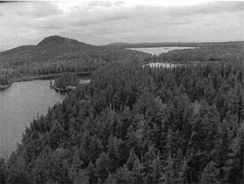
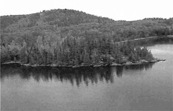
The Trollope Lake Burnt Hill Poplar Spruce Conservation Reserve, consisting of approximately 2,108 ha of Crown land, is located approximately 55 km northeast of the Town of Kirkland Lake, 50 km east of the Town of Matheson and 10 km west of the Ontario/Quebec border. This site is found within Frecheville and Stoughton Townships in the District of Timiskaming (Locator Map, Appendix #7). The conservation reserve is situated in the Lake Abitibi Site Region 3E (Hills, 1959) in the site District of Kirkland Lake (3E-6). The site region or Eco-region is characterized by stands of spruce, fir, poplar and birch on moderately sloping terrain. Red and White pine trees occur on sand regions and elm and white cedar are found only in protected wetland areas. The landform is typically flat to gently rolling, glacial clay and sand plain with local peatlands and wetlands. The landscape is broken throughout by glacial features such as moraines, eskers, kames and kettles. The forest climate type is mid-humid, mid-boreal (Poser 1992). Moderately broken plains of granite and low-based bedrock with thin covers of sand and silty sand characterize the eco-district. Several trains of glaciolfluvial sand and gravel also occur (Hills 1959).
Trollope Lake Burnt Hill Poplar Spruce Conservation Reserve appears to be immediately underlain by areas of Bedrock Outcrop, Bedrock-Drift Complex, Ice Contact Stratified Drift Deposits, Glaciolacustrine Deposits, and Organic Deposits. Bedrock terrain dominates the surficial geology of this conservation reserve. The original gap analysis stated the main landforms from the provincial landform coverage were weakly broken bedrock, moderately broken bedrock and lacustrine deposits. Bedrock covers approximately 75% of the site with lacustrine deposits found on the tip of the west boundary and the rest on the east side (Map 1b, Appendix #8). Lee (1977) also records the conservation reserve as consisting mainly of bedrock ridges with ground moraine consisting of till as the subordinate landform. A small area on the east side of the reserve consists of sandy/gravelly glaciofluval deposits while on the west side it is a till/sand ground moraine. Portions of the south side and the extreme east side consist of clay, and silty glaciolacustrine deposits.
An area of Ice-Contact Stratified Drift Deposits is located in the northeast part of the conservation reserve. It is probable that these deposits were established as a subaquatic outwash fan during the Angliers Phase of glacial Lake Ojibway. A vast glaciolacustrine plain dominates the region surrounding the conservation reserve. Portions of this glaciolacustrine plain, which is largely underlain by glaciolacustrine silt and clay, have been encompassed by the conservation reserve. Areas immediately underlain by 'fine-grained, Glaciolacustrine deposits are located in the south central, southeast, central east, extreme northeast, and extreme northwest parts of the conservation reserve. Various areas immediately underlain by organic deposits are also present within the conservation reserve. Several relatively extensive areas of Organic Deposits are located in the northwest, north central, and central east parts of the conservation reserve. Finally, an area of Organic Deposits, which occurs predominantly as a veneer overlying fine-grained, glaciolacustrine deposits is located in the extreme south central part of the conservation reserve.
Physiographically, the conservation reserve is situated on the Abitibi Uplands, a section of the James Region, a subdivision of the shield. It is characterized by crystalline Archaen rocks and has broad rolling surfaces. Most of the uplands lie between 900 and 1200 feet elevation (Bostock 1970).
The conservation reserve is found in the Northern Clay section (B.4) of Rowe’s (1972) Boreal Forest Region. The forests are found on widespread surface deposits of water-worked tills and lacustrine materials and on a fairly level topography, inherited from the glacial Lake Ojibway. Black spruce is the most common tree species of this section, covering gently rising uplands as well as the lowland flats. Spruce-cedar swamps occur in extensive areas where cedar only grows to tree size on swamp edges.
Fine hardwood or mixwood stands of trembling aspen, balsam poplar, balsam fir, white spruce and black spruce can be found in areas where improved drainage occurs either by changes in relief or by shallowly buried coarse drift or alongside rivers and lakes.
4.2 Administrative description
The legal boundaries of the Trollope Lake Burnt Hill Poplar Spruce Conservation Reserve were filed on April 14, 2004 with the Office of the Surveyor General, Ministry of Natural Resources in Peterborough, Ontario. This site was passed into regulation on *** ##, 2004 (O.Reg. ###/##)(site not yet regulated).
4.3 History of site
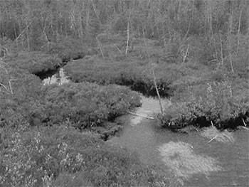
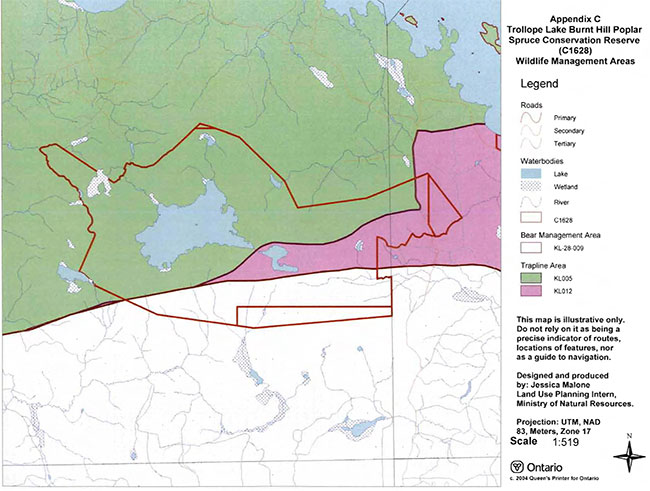
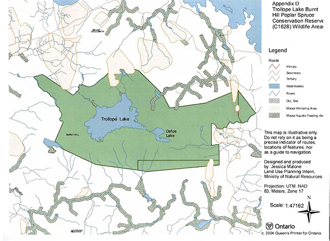
Historically the site has been used for fish and wildlife activities. The conservation reserve is situated on portions of two trapline area’s (KL005 & KL012) and a Bear Management Area (KL-28-009) (Map 3A, Appendix #8). Other values include a moose wintering area in the north central area of the site, a moose aquatic feeding area in the creek at the northwest corner of Trollope Lake and a lake trout fishery in the Trollope area. This lake is used for winter fishing as indicated by the fishing huts on the islands/shorelines observed during aerial reconnaissance. Observations of bear and moose hunt camps were made along the Stoughton Road, which passes through the east side of the conservation reserve, during ground recreation inventory reconnaissance.
4.4 Inventories
| Type of inventory | Method | Date | Report |
|---|---|---|---|
| Life Science | Aerial reconnaissance | June 2003 | Barbara Burkhardt; OMNR, Lori King; OMNR & Sean Longyear; OMNR |
| Earth Science | Aerial reconnaissance | June 2003 | Rik Kristjansson |
| Recreation | Aerial reconnaissance | July 2003 | Rick Gordon; OMNR & Jenn Telford; OMNR |
Table 2. Inventory data
5.0 State of the resource
5.0.1 Representation
This site has a great esker complex west of Trollope Lake, with little human disturbance due to the lack of access. One tertiary road (Road Access Map, Appendix #8) runs through the east edge of this site with evidence of other old trails, which lead into the site, fading as they become overgrown. Forest Resource Inventory (FRI) data shows the site to be dominated by trembling aspen mixedwood (14.2%), white birch conifer (14.0%), black spruce (12.6%) mixwood stands and trembling aspen hardwood stands (10.9%) (Map 2A, Appendix #8). Several black ash stands were also present, usually in association with wetter sites. Rocky areas around Trollope Lake were dominated with black spruce, not typical of this type of site. Many other forest communities are present but they are small in comparison and fractured and add very little to the diversity of the site.
During the aerial reconnaissance survey, several changes to the FRI were noted (Burkhardt 2002). A stand dominated by poplar east of Trollope Lake had in actuality very little trembling aspen. This stand followed a creek flowing into Trollope Lake and contained mostly cedar, black spruce, shrubs and infrequent trembling aspen. An area designated a treed muskeg on the west side of the road resembled a loading area for logging trucks. Several mixed stands had more dominant species. More rocky area could have been delineated from the species stands.
The forest communities are redefined as Standard Forest Units (SFU's). Northeastern Region SFU's are used in forest management planning to more effectively describe the forest canopy. There were nine SFU's on the site, the dominant ones being P01 (poplar), MW2 (spruce fir mixed), MW1 (jack pine mixed), and AP1 (spruce fir) and account for approximately 83% of the site (Map 2B, Appendix #8). Other SFU's were SB1 (black spruce lowland), PJ2 (pine spruce), PJ1 Oack pine), BW1 (birch poplar), and LC1 (lowland conifer).
The majority of the stand is under the age of 90 (Map 2C, Appendix #8). A few jack pine and cedar stands were between 90-119 years of age. The even distribution of the age groups suggests a natural disturbance occurred in the area. The 30-59 age class is located around the north and east shore of Trollope and Defoe Lakes and extends from the south-central shore of Trollope Lake. The 60-89 age groups are located from the west-central arm of the site to the west side of Trollope Lake, from the southeast corner of Trollope Lake to the south site boundary and around to the east side of the site. There are no old growth stands in the site (Map 5, Appendix #8).
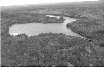
Wet lands found throughout the reserve were usually associated with creeks or lakes (Map 3B, Appendix #8). Several stands containing black ash were classified as hardwood swamps. A poplar stand listed in the FRI was actually a conifer swamp consisting of white cedar, black spruce and shrubs. Some areas were transferred into open water marshes or meadow marshes as a result of beaver activity. Other wetlands include semi treed/treed bogs, meadow marshes, shore fens, open graminoid bogs and thicket swamps. Trollope Lake has some emergent and sub-emergent vegetation along its shorelines. The reserve is located within the tertiary watershed 4MA of the Moose River Basin.
5.0.2 Quality of representation
The quality of the representation of the current characteristics of the natural features found within the conservation reserve are as important as the overall representative features that are being protected. A number of factors are considered in evaluating a site and they include the following criteria: diversity, condition, ecological factors, special features and current land use activities.
a) Diversity:
Diversity is a measure of the site’s life and earth science heterogeneity. The evaluation is based on the number and range (variety) of the natural landscape features and landforms for earth science values and the relative richness and evenness of the site’s life science components. The original gap analysis at 3637 hectares had 43 landform: vegetation combinations based on the provincial landform coverage and different forest communities. The dominant combinations were medium aged poplar and spruce on weakly broken bedrock and young/old poplar and medium spruce on lacustrine deposits (Ritchie & Thompson 1997). Using the current area and same provincial landforms the combination was approximately 47, but this was using recent forest community classifications and not including wetlands.
In reviewing the forest communities and wetlands present it appears diversity is moderately skewed. Although there are 31 different forest communities and wetlands present in the site, three communities (PO mixwood, Bw conifer dominant, and Sb mixwood) account for approximately 40% of the area. The majority of the communities are below 100 hectares in size. In analysis two communities (Ce dominant conifer and PO/Sw true mixed) can be removed since they are not visible on the map, were fragmented by vector
b) Condition:
Condition is the degree of past human and natural disturbance observed or recorded for the site. In this site the disturbance is considered to be low. The only known manmade disturbance is the secondary forest harvest access road at the east side of the site associated with the harvest block along the east and further north of the site boundaries. Harvesting has occurred around most of the site and within the northwest arm of the site, but, for the most part, not up to the boundaries. An aggregate pit is situated within the forest reserve along the east side of the forest access road. The only other indications that the site is used by humans are the ice-fishing huts placed on islands and along the shores of Trollope Lake and the hunting camps situated along the forest road that suggest moose and bear hunting (witnessed during ground recreation values inventory).
c) Ecological factors:
Ecological factors refer to the current design of the conservation reserve as noted by its size, shape, and ability to protect core ecosystems from adjacent land use activities. Whenever possible, a site’s boundaries should be created to include the greatest diversity of life and earth science features to provide the maximum ecological integrity. It should be ecologically self-contained, bound by natural features and include adequate area to protect the core ecosystems from intrusive adjacent land use influences (OMNR 1992).
The Trollope Lake Burnt Hill Poplar Spruce Conservation Reserve has a very irregular shape and the boundaries are vectored. With so many vectored boundaries, it is difficult to determine exactly where the site lies without the aid of a GPS, thus running the risk of encroachment of adjacent land use activities. With the vectors, many of the forest communities become fragmented and do very little to protect the core values. This also applies to the arms on the east and west side. Their narrow configuration and fragmented forest communities offer little protection capabilities to core values from adjacent land use activities. If this site were a candidate for the Room to Grow program several modi-fications could be made. On the east side, the site could be extended to the secondary road. On the west arm, the trembling aspen and jack pine boundary could be removed and the bog complex edge used instead. On the west side of the north central point the vector border could be extended to the natural line, distinct on aerial photography, between forest and bedrock. South of the site, the borders could be extended to the harvested areas as few distinct biological features occur within this area. Overall, this would make the reserve rounder and offer more protection to core values.
Currently we do not have minimum size standards for conservation reserves under different landscape conditions. However, a minimum size standard of 2000 ha has been established for natural environmental parks by Ontario Parks (OMNR 1992). This minimum standard was necessary to protect representative landscapes as well as allow for low intensity recreational activities. The conservation reserve encompasses a total area of 2,108 hectares and therefore meets the minimum standard. Although it is over 2000 hectares in size the configuration of the site with its vectored boundaries and irregular shape offers reduced protection for the representative landscapes.
d) Special features:
The major features that are present within this conservation reserve include:
- The even age distribution of forest communities suggesting a natural disturbance approximately 30-60 years ago in one area and 60-90 years ago in the other areas.
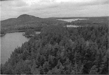
- The overall visual diversity of the site is interesting from the bedrock exposures, particularly Burnt Hill, to the clear, brown-coloured Trollope and Defoe Lakes, from the wetlands to the rolling topography.
e) Current land use activities
Only a small number of uses are known to be associated with this site. Activities include fishing, hunting, trapping, minimal All Terrain Vehicle (ATV) use, and snowmobiling.
5.0.3 Summary
Trollope Lake Burnt Hill Poplar Spruce Conservation Reserve is a protected landform type represented by an area primarily dominated with medium aged poplar and spruce on weakly broken bedrock, and young/old poplar and medium aged spruce on lacustrine deposit. In addition some mixed forest stands and pure jackpine stands were observed in the northern portion of the site. A total of 47 landform: vegetation combinations were determined. The creeks flowing into and out of this site have been identified as sensitive areas. Any development from the outside adjacent to these creeks causing erosion or contamination to the waterways may have an effect on the waterway and/or wetlands present within the site. This site will have only moderate to low activity attraction capability. The site’s location within a forested landscape and primarily off-road access limits its current geographical significance and its backcountry travel qualities. The use of all-terrain vehicles on the secondary road into the eastern edge of the site for recreational hunting purposes could be a concern.
Natural heritage representative features
This site is characterized by stands of spruce, fir, poplar and birch on moderately sloping terrain. Red and White pine trees occur on sand regions and elm and white cedar are found only in protected areas. The landform is typically flat to gently rolling, glacial clay and sand plain with local peatlands and wetlands. The landscape is broken throughout by glacial features such as moraines, eskers, kames and kettles. The forest climate type is mid-humid, mid-boreal. Moderately broken plains of granite and low-based bedrock with thin covers of sand and silty sand characterize the eco-district. Several trains of glaciofluvial sand and gravel also occur. The dominant forest landscape combinations were found to be medium aged poplar and spruce on weakly broken bedrock and young/old poplar and medium spruce on lacustrine deposits.
| Landform | Vegetation | |||
|---|---|---|---|---|
| Weakly Broken Bedrock | Balsam Fir Pure | |||
| Weakly Broken Bedrock | Balsam Fir Conifer Mixwood | |||
| Weakly Broken Bedrock | Balsam Fir Mixwood | |||
| Weakly Broken Bedrock | Cedar Predom Conifer | |||
| Weakly Broken Bedrock | Cedar Dom Conifer | |||
| Weakly Broken Bedrock | Jackpine Conifer Mixed | |||
| Weakly Broken Bedrock | Jackpine Predom Conifer | |||
| Weakly Broken Bedrock | Jackpine Mixwood | |||
| Weakly Broken Bedrock | Black Spruce Pure | |||
| Weakly Broken Bedrock | Black Spruce Predom Conifer | |||
| Weakly Broken Bedrock | Black Spruce Conifer Mixed | |||
| Weakly Broken Bedrock | Black Spruce/Poplar True Mixed | |||
| Weakly Broken Bedrock | Black Spruce Hardwood Dom | |||
| Weakly Broken Bedrock | White Spruce Pure | |||
| Weakly Broken Bedrock | Black Ash Pure | |||
| Weakly Broken Bedrock | White Birch Pure | |||
| Weakly Broken Bedrock | White Birch Conifer Dom | |||
| Weakly Broken Bedrock | White Birch Mixwood | |||
| Weakly Broken Bedrock | White Birch/Jackpine True Mixed | |||
| Weakly Broken Bedrock | White Birch/Black Spruce True Mixed | |||
| Weakly Broken Bedrock | Poplar Pure | |||
| Weakly Broken Bedrock | Poplar Predom Hardwood | |||
| Weakly Broken Bedrock | Poplar Hardwood Mixed | |||
| Weakly Broken Bedrock | Poplar Mixwood | |||
| Weakly Broken Bedrock | Poplar Conifer Dominant | |||
| Weakly Broken Bedrock | Poplar/Jackpine True Mixed | |||
| Weakly Broken Bedrock | Poplar/White Spruce True Mixed | |||
| Weakly Broken Bedrock | Treed Muskeg | |||
| Moderately Broken Bedrock | Jackpine Predom Conifer | |||
| Moderately Broken Bedrock | Poplar Hardwood Mixed | |||
| Moderately Broken Bedrock | Treed Muskeg | |||
| Moderately Broken Bedrock | Poplar Conifer Dominant | |||
| Moderately Broken Bedrock | Black Spruce Predom Conifer | |||
| Moderately Broken Bedrock | Poplar/Jackpine True Mixed | |||
| Moderately Broken Bedrock | White Spruce Pure | |||
| Moderately Broken Bedrock | White Birch Conifer Dom | |||
| Moderately Broken Bedrock | Poplar Mixwood | |||
| Moderately Broken Bedrock | Poplar Pure | |||
| Lacustrine Deposit | Poplar Hardwood Mixed | |||
| Lacustrine Deposit | Black Spruce/Poplar True Mixed | |||
| Lacustrine Deposit | Poplar Mixwood | |||
| Lacustrine Deposit | Poplar Pure | |||
| Lacustrine Deposit | Balsam Fir Pure | |||
| Lacustrine Deposit | White Birch Conifer Dom | |||
| Lacustrine Deposit | Treed Muskeg | |||
| Lacustrine Deposit | Black Spruce Conifer Mixed | |||
| Lacustrine Deposit | Black Spruce Pure | |||
| Lacustrine Deposit | Poplar Predom Hardwood | |||
Table 3: Vegetation types - based on forest community and landform data obtained by Rik Kristjansson, 2001
5.0.5 Forest Resource Inventory (FRI) data
- Dominant species, wetlands, and depleted areas
- See Forest Communities Map (Map 2a, Appendix #8)
5.1 Social/economic interest in area
5.1.1 Linkage to local communities
The Trollope Lake Burnt Hill Poplar Spruce Conservation Reserve is a 2,108 hectare parcel of crown land that is situated approximately 55 km northeast of the Town of Kirkland Lake, 50 km east of the Town of Matheson and 10 km west of the Ontario/Quebec border. This site is found within Frecheville and Stoughton Townships in the District of Timiskaming (Locator Map, Appendix #7).
Current uses are related to consumption of fish and wildlife resources, snowmobiling and trapping. Potential recreational activities could include hiking, rock climbing, canoeing, and possible non-consumptive uses such as bird watching, photography or nature study.
5.1.2 Heritage estate contributions:
The Trollope Lake Burnt Hill Poplar Spruce Conservation Reserve contributes to the province’s parks and protected areas system through its regulation, representation and the long-term management of natural heritage values. Through allocation of these lands to the Parks and Protected Areas system, the province has ensured a certain level of permanence by distinguishing the site and sits values from the broader general use or more extensively managed landscape. In addition, its natural features are, and will be, available for present and future generations to enjoy and explore.
5.1.3 Aboriginal groups
Although the CR is not located within identified First Nations notification area, it is adjacent to the Wahgoshig First Nation territory. On that account they were been invited to participate during the Planning Process. They were notified of the planning and requested a draft copy of the SCI be sent to them. A second meeting was set up to receive feedback from the community. No major concerns were raised at this time.
5.1.4 Mining interests
There are two current mining leases (L1225950 & L 1225949) within the conservation reserve (shown as a Forest Reserve). Mining and surface rights have been withdrawn from staking within the conservation reserve’s boundaries under the Mining Act (RSO 1990 Chapter M.14).
5.1.5 Forest and fire management history:
This site has not been affected by recent forest management activities, With the exception of maintenance. Surface grading and overhanging brush removal of the forest access road, east side of site, was done during the summer of 2003 in preparation for upcoming forestry operations to the north and west of the site. The last known forestry harvesting operation within the site boundaries occurred in the northwest arm of the site in 1983. A recent aerial reconnaissance survey showed significant harvest zones throughout the areas surrounding the site. From 2000-2003, there was considerable area harvested to the north of the site and south of lake Abitibi.
The site has no recent burned areas within its boundary. Past natural disturbances include a forest fire in 1921 in the south portion of the site (Fire Disturbance Map, Appendix 8) and possibly the Great Fire of 1911. Flooding has occurred at some of the creeks as a result of beaver activity.
5.2 Natural heritage stewardship
Analysis of the life science targets based on landform:vegetation combinations have shown that the conservation reserve contains a minimum of 47 landform: vegetation combinations. A total of 31 separate forest communities were identified using recent forest community classifications and not including wetlands. (Geology and Forest Communities Map, Appendix 8). The dominant combinations were medium aged poplar and spruce on weakly broken bedrock and young/old poplar and medium spruce on lacustrine deposits. Although there are 31 different forest communities and wetlands present in the site, three communities (PO mixwood, Bw conifer dominant, and Sb mixwood) account for approximately 40% of the area. The majority of the communities are below 100 hectares in size. Most of the areas fall into one of two age groups; 30 to 59 or 60 to 89. There are no old growth stands and only the harvest blocks outside of the site had younger trees.
5.3 Fish and wildlife
Trollope lake is identified as a cold-water fish community. Fisheries information is limited to a mixed fishery of lake trout, lake herring (Cisco), white sucker, and various minnow species. Angling pressure in the summer is minimal due to access difficulty. Winter sees an increase in fisherpersons resulting in moderate angling pressure. Snowmobile access is available during the frozen season and visual confirmation of fish shacks has been established during aerial reconnaissance. Double-crested cormorants have been observed on the lake feeding in 2002 and may have established a colony. No recent stocking efforts have been undertaken as the lake is currently managed as a natural, self sustaining lake trout lake. Currently, no fisheries information is available for the other isolated lakes and creeks within the site. Defoe Lake has no lake survey information although it is reasonable to surmise that it shares the same fish species as Trollope (not including the lake trout). Further assessment and management will continue under the Kirkland Lake District, Elk Lake/Matheson Area Supervisor.
This area is also used for hunting and trapping. Bear and moose hunt camps were observed along the secondary forest access road that runs through the east portion of the conservation reserve. The dominant forest stands as well as open sections, kettle lakes, wetlands and bogs provide year round habitat for moose and other species. A variety of animals, including black bear, moose, fox, marten, fisher, upland game birds and migratory waterfowl inhabit the site. Most of these features are not accessible except through the secondary road or winter snowmobile trails.
5.4 Cultural heritage stewardship
To date, little is known regarding the cultural values of the Conservation Reserve as a detailed assessment of cultural resources has not been carried out.
5.5 Land use/existing development
This conservation reserve is situated entirely on Crown land and is unencumbered by any patented land, land use permits, or leases. It does however, overlap two mining claims, (L1225949, L1225950) which have been designated as forest reserves.
A forest reserve is a land use designation (LUS 7.2.3) applied to areas that were initially identified for inclusion in the conservation reserve (CR) but, upon subsequent detailed examination, were determined to include existing mining leases or claims.
Mining and surface rights have been withdrawn from staking within the conservation reserve boundaries under the Mining Act (RSO 1990 Chapter M.14). Therefore, no new claims can be staked within the CR boundary. The intent is that the forest reserve (FR) will be added to the CR if the claim or lease is retired through normal process.
Policies for FR's are similar to the policies for new CR's, except that mining and related access will be allowed in a forest reserve.
5.6 Commercial land use
Present commercial use activities overlapping the site include one bear management area (KL-28-009) and two traplines (KL-005, KL-012) (Values Map #3A, Appendix #8).
5.7 Tourism/recreation use/opportunities
Some of the features within the site associated with possible recreational use include large and small mammals, mixed forests, and aquatic flora and fauna. Existing recreational uses in this site and immediately surrounding the site include trapping, large game hunting, small game hunting, snowmobiling, canoeing and fishing. There is also potential for activities such as ATV use, bird watching and nature study.
For a more detailed report and summary of the recreational use and potential, refer to the Recreational Inventory Check-sheet (Appendix 3).
5.8 Client services
Currently, visitor services are limited to responding to inquiries about access, natural heritage features and boundaries. No formal information or interpretive facilities currently exist within the conservation reserve. Other customer services available through the Kirkland Lake District office include providing clients with maps, fact sheets, and other information gathered on the area, such as the earth/life sciences and recreational inventory work.
6.0 Management guidelines
6.1 Management planning strategies
The land use intent outlined in the OLL LUS (MNR, 1999) provides context and direction to land use, resource management, and operational planning activities on Crown Land in the planning area and within OLL site boundaries. Commitments identified in the OLL LUS and current legislation (Policy 3.03.05 PLA) forms the basis for land use within the Trollope Lake Burnt Hill Poplar Spruce Conservation Reserve. Management strategies for these uses must consider the short and long-term objectives for the conservation reserve. For up to date information on permitted uses refer to the Crown Land Use Atlas (MNR, 2002) (Appendix 6).
Proposed new uses and development will be reviewed on a case-by-case basis. A Test of Compatibility, (Procedural Guideline B-Land Uses (Appendix 4)) must be completed before proposals can be accepted. In all cases, ensuring that the natural values of the conservation reserve are not negatively affected by current and future activities will be the priority. Therefore any application for new specific uses will be carefully studied and reviewed.
6.1.1 Forest reserves
Under the OLL LUS, mining and related access will be allowed in a forest reserve. For those activities that could negatively influence the natural heritage values within the FR and/or the CR, the district will work with the proponent to identify and mitigate potential mining or natural heritage concerns. Mining will not occur in any portion of the regulated CR boundary.
6.2 "State of the resource" management strategies
The development of this SCI and the long term management and protection of the Trollope Lake Burnt Hill Poplar Spruce Conservation Reserve will be under the direction of the MNR's Kirkland Lake District, Elk Lake Matheson Area Supervisor. The following management strategies have been created to achieve the goal and objectives stated earlier in this management document.
6.2.1 Natural heritage stewardship
The management intent for the Trollope Lake Burnt Hill Poplar Spruce Conservation Reserve is to allow for natural ecosystems, processes and features to operate undisturbed with minimal human interference while providing educational, research and recreational activities. Forest ecosystem renewal will only be entertained via a separate vegetation management plan. As part of any future vegetation management plan the site and its Site EcoDistrict will be re-evaluated with respect to their known landform/vegetation features to determine if the past harvested areas could contribute additional landform/vegetation values to the Site EcoDistrict.
In addition, the vegetation management plan will need to determine but not be limited to:
- the restoration ecology objectives (e.g. representation) for the area in context with the Site EcoDistrict;
- consideration of current provincial strategies (e.g. white pine);
- consideration of larger long-term conservation reserve (e.g. recreational objectives), and possibly landscape, objectives (e.g. contributions to landscape wildlife objectives).
Fire is recognized as an essential process fundamental to the ecological integrity of conservation reserves. In accordance with existing Conservation Reserve Policy and the Forest Fire Management Strategy for Ontario, forest fire protection will be carried out as on surrounding lands.
Whenever feasible the MNR fire program will endeavor to use "light hand on the land" techniques, which do not unduly disturb the landscape, in this conservation reserve. Examples of light hand on the land techniques may include limiting the use of heavy equipment, utilizing high water bomber drops, non-use of foaming agents, or limiting the number of trees felled during the fire response efforts.
Opportunities for prescribed burning to achieve/emulate ecological or resource management objectives may be considered. These management objectives will be developed with public consultation prior to any prescribed burning, and reflected in the document that provides management direction for this conservation reserve. Plans for any prescribed burning will be developed in accordance with the MNR Prescribed Burn Planning Manual, and the Class Environmental Assessment for Provincial Parks and Conservation Reserves (approval pending).
Defining compatible uses, enforcing regulations and monitoring and mitigating issues will protect all earth and life science features. Industrial activities such as commercial timber harvest and new hydro generation will not be permitted within the conservation reserve. Permits for fuel-wood will not be issued. New energy transmission, communication and transportation corridors or construction of facilities are not permitted within the boundaries of the conservation reserve. Such structures negatively impact the quality of the representative features that require protection. Alternatives should be reviewed via larger landscape planning processes. New roads for resource extraction will not be permitted. Other activities that do not pass a Test of Compatibility will be prohibited (MNR Policy 3.03.05, 1997).
The introduction of exotic and/or invasive species will not be permitted. Programs may be developed to control forest insects and diseases where they threaten significant heritage, aesthetic, or economic values. Where control is desirable, it will be directed as narrowly as possible to the specific insect or disease. Biological or non-intrusive solutions should be applied whenever possible.
The collection/removal of vegetation and parts thereof will not be permitted; however, subject to a Test of Compatibility, the Area Supervisor may authorize such activities for purposes of rehabilitating degraded sites within the reserve, collecting seeds for maintaining genetic stock and/or for inventory or research purposes.
Silvicultural assessment of the previous clear-cut area in the northwest arm of the site should be conducted to support any future vegetative management plan. The evaluation should consider but not be limited to the following objectives:
- describing the current forest condition;
- determining soil type and depth;
- defining potential restoration prescriptions. Such prescriptions must consider current silvicultural science and guidelines and additional objectives established by the MNR.
MNR will provide leadership and direction for maintaining the integrity of this site as a heritage estate. To ensure MNR protection objectives are fully met within the conservation reserve, activities on the surrounding landscape must consider the site’s objectives and heritage values. Research, education and interpretation will be encouraged to provide a better understanding of the management and protection of the natural heritage values and will be fostered through local and regional natural heritage programs, initiatives and partnerships.
The conservation reserve will be managed by allowing natural ecosystems, processes, and features to function normally, with minimal human interference.
6.2.2 Fish and wildlife
Fish and wildlife resources will continue to be managed in accordance with specific policies and regulations defined by the Ontario Ministry of Natural Resources under the Fish and Wildlife Conservation Act and the Kirkland Lake District, Elk Lake/Matheson Area Supervisor. The final decision to allow stocking in the Trollope Lake Burnt Hill Poplar Spruce Conservation Reserve lies with the approval of the Kirkland Lake District Manager.
Fishing and hunting is expected to continue at a low level of intensity. A planned trail and viewing area development may enhance back country camping opportunities and wildlife viewing activities. Any future trail development will require a Test of Compatibility.
6.2.3 Cultural heritage
When possible, the Ministry of Natural Resources will continue to work with the Ontario Ministry of Culture, Tourism and Recreation in identifying archaeological sites to be protected. To fully manage and protect sites, the development of field surveys would be required. However, at this time additional field surveys within the conservation reserve are not recommended.
Development, research and education proposals may be considered in accordance with the Test of Compatibility and Conserving a Future for our Past: Archaeology, Land Use Planning & Development in Ontario, Section 3 (MCzCR, 1997).
6.2.4 Land use and development
The sale of lands within the conservation reserve is not permitted as per the OLL LUS (MNR, 1999). Existing authorized trails can continue to be used and maintained, unless there are significant demonstrated conflicts. New trails will only be allowed if a Test of Compatibility is passed. Any new trail development will require an amendment to the SCI. The cutting of trees for non-commercial purposes (e.g. fuelwood) is not permitted except as required for approved development activity (e.g. trail, viewing site, etc.). New roads for resource extraction may be permitted under the Class Environmental Assessment Act (Ontario Parks, 2004).
There are no other forms of tenure in the conservation reserve other than legal agreements with registered trappers, and bear management area operators. The construction of new trap cabins will not be permitted; however, existing cabins will be allowed to remain (LUS MNR, 1999).
Traditional uses within the conservation reserve will continue to be permitted; however, the goal will be to resolve conflicts regarding incompatibility between uses and to ensure that identified values are adequately protected.
6.2.5 Commercial use
All existing commercial resource use activities (i.e. trapping, baitfish harvesting, fishing and wild rice harvesting) are permitted to continue and new uses (with the exception of commercial bear hunting) may be introduced, subject to protection of the conservation reserve’s natural heritage values (i.e. Test of Compatibility).
Commercial bear hunting (within BMA) operations may continue and the transfer of existing licenses is allowed, providing the activity has been licensed/permitted since January 01, 1992. Licenses to provide Bear Hunting Services will not be issued in areas where issuance has not occurred since January 01, 1992.
Existing commercial fur harvesting operations are permitted to continue. New operations may be considered subject to a Test of Compatibility.
6.2.6 Aboriginal interests
The Trollope Lake Burnt Hill Poplar Spruce Conservation Reserve is not within the Wahgoshig First Nation’s identified notification area, however is within close proximity and invitations for comment and participation were extended. Aboriginal and treaty rights will continue to be respected throughout the management of this conservation reserve. Any future proposal(s) and or decision(s) that have potential impact(s) on individual aboriginal values and or communities will involve additional consultation with the affected aboriginal groups. Neither the regulation of this conservation reserve nor the approval of this SCI will have bearing on the Wahgoshig traditional land uses.
6.2.7 Tourism/recreation
The earth and life science features and their protection, shall be the overall theme for tourism. Small-scale infrastructures for enhancing tourism and recreation (i.e., warm-up shelter) may be considered, providing they pass a Test of Compatibility and other MNR requirements.
Most recreational activities that have traditionally been enjoyed in the area can continue provided they pose no threat to the natural ecosystems and features protected by the conservation reserve. These permitted activities include walking, hiking, wildlife viewing, fishing, hunting, snow shoeing, and cross-country skiing.
Snowmobiles and ATVs are permitted on existing trails and forest access roads within the Conservation Reserve. Under the OLL LUS (MNR, 1999), all mechanized travel is restricted to existing trails. Off trail vehicle use is permitted for the retrieval of game only. The use of existing trails, within the Trollope Lake Burnt Hill Poplar Spruce Conservation Reserve, does not degrade the values of this site.
Existing trails for hiking, snowmobiling, ATV use, cycling, horseback riding and cross-country skiing can continue. To ensure the quality of the representation is maintained, all trails and old forest access roads (Road Access Map, Appendix #8) within the site should be identified via new technologies (i.e. GPS) to ensure a record of these features exists. New trails can be considered through a Test of Compatibility.
Finally, conflict resolution between recreational uses will be a priority. This will be achieved by adhering to the objectives of this SCI with input from relevant user groups. The level of safety and compatibility between activities will determine permitted uses (i.e. Test of Compatibility).
6.2.8 Client services
Clients indicating their interest in the management, planning and future use of this conservation reserve will be put on a mailing list and notified of any future planning concerning the site.
Present client services such as supplying maps, fact sheets and other information will also continue. Information may be delivered from different sources; however, MNR will be the lead agency for responding to inquiries regarding access, permitted and restricted activities, values and recreation opportunities. A management agreement may be pursued with an appropriate partner to share responsibilities for information services and the delivery of other aspects of this SCI in the future.
6.3 Specific feature/area/zone management strategies
There are no specific management strategies for the maintenance/protection/enhancement of selected resources within the conservation reserve. Development of such strategies will require an amendment to the SCI.
6.4 Promote inventory, monitoring and assessment reporting (IMAR), and research
Scientific research by qualified individuals, which contributes to the knowledge of natural and cultural history, and to environmental and recreational management, will be encouraged.
Additional life science inventory or research is required at this time to refine values and features. Additional assessment and monitoring of the disturbed areas, including trail and old road locations, within the site should occur prior to any additional management direction being finalized in a Vegetation Management Plan for the area.
Research related to the study of natural processes will be encouraged provided it does not harm the values of the reserve. The Elk Lake/Matheson Area Supervisor or District Manager may approve the removal of any natural or cultural specimen by qualified researchers. All such materials removed remain the property of the Ministry of Natural Resources. All research programs will require the approval of the Ministry of Natural Resources and will be subject to Ministry policy and other legislation.
New research developments such as campsites, privies, trails or developed access points or activities will not be considered until a Test of Compatibility is conducted and the proposal is approved by the Elk Lake/ Matheson Area Supervisor or District Manager. The Test of Compatibility or environmental screening process could include a review of the demand for structures or activities and may require more detailed life or earth science or cultural information and possibly more detailed management plan.
Approved research activities and facilities will be compatible with the site’s protection objective. Permanent plots or observation stations may be established to which researchers can return over time. Any site that is disturbed will be rehabilitated as closely as possible to its original state.
6.5 Implementation, and plan review strategies
Trollope Lake Burnt Hill Poplar Spruce Conservation Reserve SCI will be reviewed on an ongoing basis and as required.
Implementation of the SCI and management of the reserve are the responsibility of the Elk Lake/Matheson Area Supervisor. Partnerships may be pursued to address management needs.
If changes in management direction are needed at any time, the significance of the changes will be evaluated. Minor changes that do not alter the overall protection objectives may be considered and approved by the District Manager without further public consultation and the plan will be amended accordingly. In assessing major changes, the need for a more detailed Resource Management Plan will first be considered. Where a Resource Management Plan is not considered necessary or feasible, a major amendment to this SCI may be considered with public consultation. The Regional Director must approve major amendments.
6.6 Marketing strategies
Trollope Lake Burnt Hill Poplar Spruce Conservation Reserve will be marketed as a representative natural area having earth and life science values, as well as certain recreational values. Marketing efforts to increase use are not a priority and will be kept to a minimum.
6.7 Boundary identification
There is no stated policy to mark the boundaries of a Conservation Reserve. Local management discretion can be used to determine where boundary marking may be appropriate. In order for restrictions to be enforceable, signs must be placed in accordance with the Trespass to Property Act or subsection 28 (1) of the Public Lands Act to advise against any recreational activities.
7.0 References
Boissonneau, AN., 1968. Timiskaming and Nipissing. Surficial Geology; Cartography by Lands and Surveys Branch.
Chamber, B.A., Naylor, B.J., Niepoller, J., Merchant, B., and Uhlig, P. 1997. Field Guide to Forest Ecosystems of Central Ontario.
Crins, W.J. and P.W.C. Uhlig. 2000. Ecoregions of Ontario: Modifications to Angust Hill’s Site Regions and Site Districts- Revisions and Rationale.
Geomatics International. 1994. CCEA Case Studies on Ecoregions Gary Analysis: Proposed Methodology for Determination of Representatives. Report prepared for the Canadian Council on Ecological Areas.
Gordon, R.B. 2003. Ground Reconnaissance Notes.
Hills, G.A. 1959a. A Ready Reference to the Description of the Land of Ontario and its Productivity.
Hills, G.A. 1959b. Hills Mapping.
Kristjansson, R. 2002. Earth Science Planning Summary- Trollope Lake Burnt Hill Poplar Spruce (C1628) and aerial land form/survicial material interpretation.
Ministry of Citizenship, Culture and Recreation (MCzCr). 1997.Conserving a Future for our Past: Archaeology, Land Use Planning & Development in Ontario.
NTS topographic mapping (32 D/NW ).
OFRI. 1994a. Boreal East Landforms Mapping - Satellite Imagery.
Ontario Ministry of Natural Resources. 1:20 000 1994 Air Photos.
Ontario Ministry of Natural Resources. 1983. Kirkland Lake District Land Use Guidelines.
Ontario Ministry of Natural Resources. 1995. Forest Resource Inventory Mapping (Ages Corrected).
Ontario Ministry of Natural Resources. 1997c. Ontario Watershed Mapping.
Ontario Ministry of Natural Resources. Lakes 1:600 000 Mapping.
Ontario Ministry of Natural Resources. MTO Roads 1:600 000 Mapping.
Ontario Ministry of Natural Resources. Patent 1:600 000 Mapping.
Ontario Ministry of Natural Resources. Railway 1:600 000 Mapping.
Ontario Ministry of Natural Resources. Townships 1:600 000 Mapping.
Ontario Ministry of Natural Resources. Transmission Lines 1:600 000 Mapping.
Ontario Ministry of Natural Resources Sault Ste. Marie District. 2001. C289 Searchmount South Forest Conservation Reserve.
Ontario Parks. 2004. A Class Environmental Assessment for Provincial Parks and Conservation Reserves.
Poser, S. 1992. Report of the status of provincial parks in the site region and districts of Ontario. Ministry of Natural Resources Report.
Rowe, J.S. 1972. Forest Regions of Canada.
Silver, M. 2002. Natural Heritage Area- Life Science Checksheet.
Thompson, J.E. 2001. Aerial Reconnaissance Notes.
Appendix 1:
Public consultation summary
| Date received | Client | Comment | Action taken | Date responded |
|---|---|---|---|---|
| Aug. 28, 2000 | 3 | Client called to confirm that boundaries on map received from Timmins were correct | Confirmed boundaries with GIS staff, emailed client | Aug. 28 |
| Sept. 21, 2000 | 421 | Interested in the Lake Abitibi Area, historical and future land use and designation. | Sent information | Sept. 21 |
| Dec. 20, 2004 | 62 | Client wrote to confirm that hunting and fishing still permitted within CRs. Expressed surprise that cormorants were named among unique species within CR. Recommended a cull be instituted to protect this "ecologically fragile area" | Sent letter reassuring that the MNR is not managing for cormorants. Directed suggestions for culling to Area bio. Confirmed that hunting and fishing will continue within CRs | Dec. 24 |
| Dec. 21, 2004 | 4 | Client called to express concern that SCI gave the impression that the MNR was managing CR for cormorants | Reviewed wording of SCI, which listed cormorant population as a special feature. Reworded this so as not to mislead public to believe the CR was created to protect cormorants. Sent letter advising client of changes | Dec. 23 |
Appendix 2: Public consultation ad
Review of draft Statements of Conservation Interest
Cl615 Maisonville Bernhardt Muskeg Maple Moraine
C1611 Shallow River Poplar Outwash
Cl628 Trollope Lake Burnt Hill Poplar Spruce
Cl600 Mistinikon Lake Uplands
C1634 Dunmore Township Balsam Fir Outwash Conservation Reserves
The Ministry of Natural Resources (MNR) invites you to review the draft statements of conservation interest (SCI) for the Maisonville Bernhardt Muskeg Maple Moraine, Shallow River Poplar Outwash, Trollope Lake Burnt Hill Poplar Spruce, Mistinikon Lake Uplands and Dunmore Township Balsam Fir Outwash Conservation Reserves. Copies of these draft documents will be available for review at the Kirkland Lake District MNR office until December 20, 2004.
The Maisonville Bernhardt Muskeg Maple Moraine Conservation Reserve is situated 10 kilometers northwest of the Town of Kirkland Lake. This conservation reserve is located within the township of Bernhardt and is 128 hectares in size. The Shallow River Poplar Outwash Conservation Reserve is situated 45 kilometers northwest of the Town of Kirkland Lake. This conservation reserve is located within the townships of Beatty and is 396 hectares in size. The Trollope Lake Burnt Hill Poplar Spruce Conservation Reserve can be found 50 kilometers east of the Town of Matheson. This conservation reserve is located within the townships of Frecheville and Stoughton and is 2108 hectares in size. The Dunmore Township Balsam Fir Outwash Conservation Reserve is found 10 kilometers northeast of the Town of Matheson. This conservation reserve is located within Beatty Township and is 396 hectares in size. The Mistinikon Lake Uplands Conservation Reserve is located 10 kilometers west of the town of Matachewan in Doon, Powell, Yarrow and Bannockburn townships. This conservation reserve is 4,330 hectares in size.
The statements of conservation interest identify area values and provide direction on resource management activity and appropriate land uses. As conservation reserves, commercial activities such as forest harvesting, mining and hydroelectric power development are prohibited from occurring within the protected area.
The Ministry of Natural Resources (MNR) is collecting comments and information regarding the draft statements of conservation interest under the authority of the Public Lands Act to assist in making decisions and determining future public consultation needs. Comments and opinions will be kept on file for use during the plan’s operating period and may be included in the study documentation, which is made available for public review.
Under the Freedom of Information and Protection of Privacy Act (1987) personal information will remain confidential unless prior consent is obtained. However, this information may be used by the Ministry of Natural Resources to seek public input on the other resource management surveys and projects. For further information on this Act, please contact Shaun Walker at
If you would like additional information or would like to supply background information or viewpoints to be considered by the planning team, please contact:
Jessy Malone or Jody Bissett
Land Use Planners
Ministry of Natural Resources
Kirkland Lake District
P.O. Box 910, 10 Government Road East
Kirkland Lake, ON
P2N 3K4
Tel:
Fax:
Comments will be accepted until December 20, 2004
Renseignement en francais:
Appendix 3: Recreational inventory checksheet
July 24 & 28, 2003
Rick Gordon and Jenn Telford
Recreational Inventory Checklist
C1628 Trollope Lake Burnt Hill Poplar Spruce Conservation Reserve
Comments:
The Trollope Lake Burnt Hill Poplar Spruce Conservation Reserve consists of 2,108 Hectares of conservation reserve and 65 Ha of forest reserve for a total of 2,173 hectares of crown land. The site is situated approximately 55 km northeast of the Town of Kirkland Lake, 50 km east of the Town of Matheson and 10 km west of the Ontario/Quebec border. This site is found within Frecheville and Stoughton Townships in the District of Timiskaming within the MNR's Northeast Region. The conservation reserve can be accessed by means of a secondary road located through the east side of the site from Highway 101. The conservation reserve is situated in the Lake Abitibi Site Region 3E (Hills, 1959) in the site District of Kirkland Lake (3E-6).
The site region or Eco-region is characterized by stands of spruce (Picea mariana), fir (Abies) (E03), poplar (Populus) and birch (B. alba) (E04) on moderately sloping terrain (015). Red (P. resinosa) and White pine (P. Strobus) (E03) trees occur on sand regions and elm (Ulmus) and white cedar (Thuja occidentalis) (E03) are found only in protected wetland areas (E08). The landform is typically flat to gently rolling (007), glacial clay and sand plain (J16 & 011) with local peatlands and wetlands (E08). The landscape is broken throughout by glacial features such as moraines (G18), eskers (G26), kames (G16) and kettles (G17). The forest climate type is mid-humid, mid-boreal (Poser 1992). Moderately broken plains of granite and low-based bedrock (J06) with thin covers of sand and silty sand (J03) characterize the Eco-district. Several trains of glaciolfluvial sand and gravel (J14) also occur (Hills 1959). This area is dominated primarily by medium aged poplar and spruce (E05) on weakly broken bedrock and young/old poplar and medium aged spruce on lacustrine (B32) deposits. In addition, some mixed forest stands (E05) and pure jack pine stands (E03) were observed in the northern portion of the site.
There are two current mining leases (L1225950 & L 1225949) within the conservation reserve (shown as a Forest Reserve). At this time the forest reserves area has been excluded from the conservation reserves overall hectarage. Mining and surface rights have been withdrawn from staking within the conservation reserve’s boundaries under the Mining Act (RSO 1990 Chapter M.14).
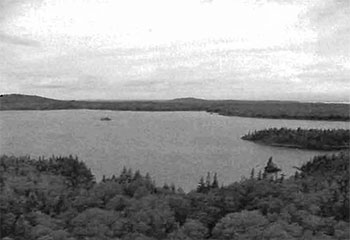
Trollope Lake (M03) is identified as a cold-water fish community. Fisheries information is limited to a mixed fishery of lake trout (Salvelinus namaycush), lake herring (Cisco) (Coregonus artedii), white sucker (Moxostoma macrolepidotum), and various minnow species (A01). Angling (f00) pressure in the summer is minimal (due to access), while winter sees an increase in fisherpersons and angling pressure is moderate, as snowmobile (d10) access becomes available (confirmation of fish shacks were observed during aerial reconnaissance). Double-crested cormorants (Phalacrocorax) (A03) have been observed on the lake feeding in 2002 and may have established a colony. No recent stocking efforts have been undertaken as the lake is currently managed as a natural self-sustaining lake trout fishery (A01). Fisheries information for the other isolated lakes and creeks within the site is not currently available. Defoe Lake (M02) has no lake survey information although it is reasonable to surmise that it shares the same fish species as Trollope (not including the lake trout). Trollope Lake is an excellent site for nesting and resting points for migratory birds and it is just west of a major migration corridor through northwestern Quebec. The lake consists of a large open waterbody with several islands (B25), rocky ridge shoreline (J07) and a bog (E0B) located on the northern shore. Sparse vegetation found along the shorelines, includes sedges (Carex spp.), cattail (Typha spp.), horsetail (Equesitum sp.), spikerush (Eieocharis spp.), buckbean (Menyanthes trifoliata), alder (Alnus sp.) and willow (Salix spp.). Burreed (Spargsnium fluctuans), hardstem bullrush (Scirpus actus), water lillies (Nuphar spp.), spikerush (Eieocharis spp.), and arrowhead (Saggitaria sp.) are the most commonly occurring emergent and floating species found in the shallow water areas.
The only known man made disturbance within the reserve is the secondary forest harvest access road (T00) at the east side of the site associated with the harvest block along the east and further north of the site boundaries. Harvesting has occurred around most of the site but not up to the boundaries. An aggregate pit is situated within the forest reserve along the east side of the forest access road.
During a recent aerial reconnaissance survey, ice shacks were spotted on the island (B25) in the middle of Trollope Lake. A boat cache was also noted on the creek system joining Trollope and Defoe Lake. This area is also home to many small (W02) and large (W03) land mammals. The site also contains areas with open wetland vegetation (E08) in the east and west corners of the site.
Current uses are related to consumption of fish (A01) and wildlife resources (W00), snowmobiling (d10) and trapping (h00). One Bear Management Area (BMA) (h01) is contained within the site as well as one active trapline (h00). Entry to this site is by aircraft or by road located at the east corner of the site. Several hunt camps were observed (during ground recreation values inventory) along the secondary forest access road that runs through the east portion of the conservation reserve suggesting that moose and bear (M03) hunting are poplar recreation activities in this area. The dominant forest stands as well as open sections kettle lakes wetlands and bogs, provide year round habitat for moose and other species. A variety of animals inhabit the site, these include black bear (Ursus americanus), moose (A. americanus), fox (V. fulvus), marten (M. martes), fisher (mustela canadensis), beaver (castor canadensis) (M02), upland game birds (h04) and migratory waterfowl (h05). Most of these features are not accessible except through the secondary road or winter snowmobile trails. The lakes are historically accessed during the winter by snowmobile (d10) for the purpose of ice-fishing (f05). The lakes within the conservation reserve hold potential recreational activities such as swimming (b13) and canoeing (b02). Other potential recreational activities could include hiking (t08), rock-climbing (r03) on Burnt Hill, and possible nonconsumptive uses such as bird watching (q10), photography (n06), nature study (n05) or drawing/painting (n02).
With the majority of the conservation reserve flat or gently rolling the large rock outcrop known as Burnt Hill is the scarcest feature, and could provide future rock climbing opportunities. The most unique feature within the reserve is the Double-Breasted Cormorant colony on an island within Trollope Lake. Activity attraction is listed as low given the remote access and non-existent trails. Scenic attractiveness is moderate once again attributed to lack of access and surrounding area being similar, however with more logging activity in the surrounding areas the conservation reserve will become more of a focal point for outdoor enthusiasts/recreation seekers in the near future. The most sensitive feature to recreational use would be the lakes, connective water complex and wetlands. The water community would also be the most sensitive to resource development specifically along the many creeks and streams flowing into the site, as any development causing erosion or contamination to the waterways would have a negative impact.
Recreation inventory checklist
| Name | Trollope Lake Burnt Hills Poplar Spruce |
|---|---|
| Map name | Abitibi |
| NTS number | 32 D/NW |
| UTM reference | 598287E |
| OBM number | 5900 53800 5500 53800 |
| Latitude | 48° 34' |
| Longitude | 79° 40' 2.69" |
| Area (ha) | 2,108.00 |
| Ownership | Crown |
| MNR region | Northeast |
| MNR district | Kirkland Lake |
| Park zone | Northeast |
| Count | Timiskaming |
| Township | Frecheville/Stough |
| Recreation |
|
| Recreation |
|
| Recreation | Features | Rating: Very High/ High/ Moderate/ Low/ N/A |
|---|---|---|
| Most scarce feature: | 5 | |
| Feature scarcity: | High | |
| Most unique feature: | 6 | |
| Activity attraction capability: | Very High | |
| Scenic attractiveness: | Moderate | |
| Geographic significance: | Moderate | |
| Feature significance: | High | |
| Most sensitive feature to recreation | 1 | |
| Feature sensitivity to recreation use: | High | |
| Most sensitive feature to resource | 1 | |
| Feature sensitivity to resource development: | Moderate | |
| Cultural/historic and archaelogical features: | N/A |
| Comments | The Trollope Lake Burnt Hill Poplar Spruce Conservation Reserve is located approximately 60 km northeast of Kirkland Lake (as the crow fly’s). It is found in Frecheville and Stoughton townships and occupies an area of 2 154 ha. This area is dominated primarily by medium aged poplar and spruce on weakly broken bedrock and young/old poplar and medium aged spruce on lacustrine deposits. In addition, some mixed forest stands and |
|---|---|
| Date compiled | Tuesday, May 06 |
| Compiler | Rick Gordon |
Source: Recreation Resource Inventory Standards and Procedures Draft Report, Gov. of British Columbia, Ministry of Forests Range, Recreation and Forests Practices Branch, March 1995.
Ontario Ministry of Natural Resources, Ontario Parks
300 Water Street, Peterborough, Ontario K9J BN1
Appendix B Trollope Lake Burnt Hill Pop Spruce Conservation Reserve (C1628) locator map
Appendix C Trollope Lake Burnt Hill Poplar Spruce Conservation Reserve (C1628) wildlife management areas
Appendix D Trollope Lake Burnt Hill Poplar Spruce Conservation Reserve (C1628) wildlife areas
Trollope Lake Burnt Hill Poplar Spruce Conservation Reserve - C1628 fact sheet
November 03, 2003
Background
On July 16, 1999, the Ontario Government released the Ontario’s Living Legacy Land Use Strategy to guide the planning and management of Crown lands in central and parts of northern Ontario. A major part of the Ontario’s Living Legacy Land Use Strategy was a government intent to establish 378 new protected areas. This commitment marks the biggest expansion of provincial parks and conservation reserves in Ontario’s history.
The proposed Trollope Lake Burnt Hill Poplar Spruce Conservation Reserve is part of the significant expansion of Ontario’s protected areas system. Following public and aboriginal consultation (2000-2003) regarding the refining of the boundary of this protected area, Ontario Regulation #### of the Public Lands Act was amended on ######, by Ontario Regulation ####, to formally establish this conservation reserve.
Size and location
The Trollope Lake Burnt Hill Poplar Spruce Conservation Reserve consists of approximately 2,108 hectares of land. This site is found in Frecheville and Stoughton Townships in the District of Timiskaming.
Area highlights
The area is dominated primarily by medium aged poplar and spruce on weakly broken bedrock and young/old poplar and medium aged spruce on lacustrine deposits. In addition some mixed forest stands and pure jack pine stands were observed in the northern portion of this site.
Land use intent
Conservation reserves are areas of Crown land set aside by regulation under the Public Lands Act.
Conservation reserves complement provincial parks in protecting representative natural areas and special landscapes. Most recreational; (e.g. hiking, skiing, tourism related uses, nature appreciation) and non-industrial (e.g. fur harvesting, commercial fishing and bait fishing) activities that have traditionally been enjoyed in the area will continue, provided that these uses do not impact on the natural features needing protection. Hunting and fishing are permitted within all new conservation reserves proposed through Ontario’s Living Legacy.
Commercial timber harvesting, mining, aggregate extraction and commercial hydroelectric development are prohibited in conservation reserves. Careful mining exploration may occur in specific conservation reserves proposed through Ontario’s Living Legacy, in areas that have provincially significant mineral potential. If a portion of a new conservation reserve is to be developed for a mine, it would be removed from the reserve, and appropriate replacement lands would be placed in regulation.
Next steps
In the future, the Ministry of Natural Resources will prepare a long-term management plan for this area. Depending upon the complexity of the issues within this conservation reserve, management planning may initially take the form of a simple Statement of Conservation Interest or a more detailed Resource Management Plan.
Planning, management and the uses permitted within the conservation reserve will be consistent with the commitments of the Ontario’s Living Legacy Land Use Strategy.
For more information
For further information on the proposed Trollope Lake Burnt Hill Poplar Spruce Conservation Reserve, please contact:
Shaun Walker, District Planner
Ministry of Natural Resources
Kirkland Lake District
Tel:
Email: shaun.walker@mnr.gov.on.ca
You may also visit the Ministry’s Internet website at
http://www.ontarioslivinglegacy.com/ [Link no longer active.] for information on Ontario’s Living Legacy.
Appendix 4 Procedural guideline B - land uses- test of compatibility (PL procedure 3.03.05)
The Conservation Reserve policy provides broad direction with regard to the permitted uses. The policy provides only an indication of the variety of uses that will be considered acceptable in Conservation Reserves. The only caution is that "any new uses, and commercial activities associated with them, will be considered on a case by case basis and, they must pass a test of compatibility to be acceptable."
What does a "test of compatibility" mean? An examination of this must start from the premise of why an area is set aside- specifically, its representative natural heritage values. Criteria are then identified to guide compatibility considerations. These criteria apply to the long-term acceptability of both existing uses and new uses.
-
Conformity to SCI/RMP: SCI describes values for which an area has been set aside and the range of appropriate uses that will be permitted in the area. SCI may also speak to the acceptability of other 'new' uses currently not occurring in the area.
The first 'test' is: "do proposed new land uses and/or commercial activities conform to the direction of the SCI/RMP for the Conservation Reserve? Would the new use(s) depart from the spirit of appropriate indicator land uses in the SCI/RMP?"
- Impact Assessment: If the proposed use(s) pass test 1 it is important to determine their impact on the area before they are approved. This should include the following:
- Impact on natural heritage values: "will the new use(s) impact any natural values in the area? If so, how and to what degree? Is it tolerable?
- Impact on cultural values: "will the new use(s) impact any historical or archaeological values in the area?
- Impact on research activities: "will the new use(s) affect research activities in the area?"
- Impact on current uses: "will the new use(s) have any negative impact on the array of current uses?"
- Impact on area administration: "will the new use(s) increase administrative cost and/or complexity?" (For example, the cost of area monitoring, security or enforcement).
- Impact on accommodating the use outside the Conservation Reserve: "Could the use(s) be accommodated as well or better outside the Conservation Reserve?"
- Impact on socio-economics of the area: "will the new use(s) affect the community (ies) surrounding the area in a positive or negative way?" (For example, will the new use make an area less remote thereby affecting a local tourism industry that is dependent on the area’s remoteness for its appeal?).
- Impact on area accessibility: "does the new use(s) give someone exclusive rights to the area or a portion of the area to the exclusion of other existing uses?"
Appendix 5 Procedural guideline C - research activities in conservation reserves
Purpose
To encourage contributions to the goal of conservation reserves by:
- Providing direction for research activities associated with conservation reserves: and
- Establishing a process for the review and approval of proposals by researchers, which could have an impact on the values protected by the conservation reserve.
Definition
Research means any investigation or study of the natural, cultural, social, economic, management or other features of characteristics of conservation reserves.
Guidelines
Research will be encouraged to provide a better understanding of the natural values protected by a conservation reserve and to advance their protection, planning and management. The Statement of Conservation Interest will define, for each conservation reserve, the key research issues, set out the parameters within which research may occur and identify research needs.
Applications and approvals
Researchers must apply in writing to the Area Supervisor for permission to conduct research. The request letter must contain a statement explaining why the proposed research should be undertaken in the particular conservation reserve in preference to another location.
Proposals will be reviewed and approved by the Area Supervisor, guided by the Statement of Conservation Interest prepared for each reserve (See Guideline A Resource Management Planning) and using Guideline B- Land Uses-Test of Compatibility. Permission must be granted in writing, including any conditions to be met in conducting the research, prior to the undertaking of any research project.
Terms and conditions
Permission to conduct research under this policy will be valid for a period of 12 consecutive months from date of issue. Permission to continue a research project for additional periods of 12 months or less may be granted upon submission of a written request and progress report. The Ministry may require the posting of collateral to assure that the terms and conditions of granting permission are to be met.
The Area Supervisor may suspend or revoke permission at any time for failure on the part of the researcher to meet:
- The intent or conditions of this policy.
- The requirements under the Public Lands Act, including all amendments, where applicable.
- The requirements under any other Act or Regulations or Ontario or Canada, including those governing the taking, handling, storing, confining, trapping, excavating and marketing any specimen, artifact, information or action (for example, scientific collector’s permit).
- The conditions and agreements specified in granting permission.
Final report
The researcher will submit copies of reports, publications and theses following from the results of the project to the Area Supervisor.
Appendix 6 Crown Land use atlas - policy report
Crown Land use policy atlas - policy report
C1628
Trollope Lake Burnt Hill Poplar Spruce
Updated: January 16, 2004
Identification:
ID: C1628
Area Name: Trollope Lake Burnt Hill Poplar Spruce
Area (ha): 2,011
Designation: Conservation Reserve - Recommended (Ontario’s Living Legacy)
MNR District(s): Kirkland Lake
Description:
The area is dominated primarily by medium aged poplar and spruce on weakly broken bedrock, and young/old poplar and medium aged spruce on lacustrine deposits. In addition some mixed forest stands and pure jack pine stands were observed in the northern portion of the site.
Land use intent:
The intent is to regulate this area as a conservation reserve.
Management of this area is also governed by the general policies contained in the Land Use Strategy (1999).
Management direction:
Those uses and management activities not listed in the following table are governed by existing conservation reserve policy. Over time the management direction will be elaborated in a Statement of Conservation Interest or Resource Management Plan. Any new uses, and commercial activities associated with conservation reserves, will be considered on a case by case basis, and they must pass a test of compatibility to be acceptable. Compatibility is normally determined through a planning process.
Commercial activities
| Activity | Permitted | Guidelines |
|---|---|---|
| Aggregate extraction | No | N/A |
| Bait fishing existing: |
Yes | Existing use permitted to continue, unless there are significant demonstrated conflicts. |
| Bait fishing new: |
Maybe | New operations can be considered, subject to the "test of compatibility". |
| Commercial fishing existing: |
Yes | Existing use permitted to continue, unless there are significant demonstrated conflicts. |
| Commercial fishing new: |
Maybe | New operations can be considered, subject to the "test of compatibility". |
| Commercial fur harvesting existing: |
Yes | Existing use permitted to continue, unless there are significant demonstrated conflicts. Existing trap cabins can continue; new cabins are not permitted. |
| Commercial fur harvesting new: |
Maybe | New operations can be considered, subject to the "test of compatibility". |
| Commercial hydro development | No | N/A |
| Commercial timber harvest | No | N/A |
| Commercial tourism existing: |
Yes | Existing authorized facilities can continue, unless there are significant demonstrated conflicts. |
| Commercial tourism new: |
Maybe | New tourism facilities can be considered during the planning for an individual reserve. |
| Bear hunting by non-residents (guided) existing: |
Yes | Existing authorized operations permitted to continue. |
| Bear hunting by non-residents (guided) new: |
No | New operations not permitted. |
| Outfitting services existing: |
Yes | Existing authorized operations permitted to continue. |
| Outfitting services new: |
Maybe | New operations can be considered during the planning for an individual reserve. |
| Outpost camps existing: |
Yes | Existing authorized operations permitted to continue. |
| Outpost camps new: |
Maybe | New operations can be considered during the planning for an individual reserve. |
| Resort/lodges existing: |
Yes | Existing authorized facilities permitted to continue. |
| Resort/lodges new: |
Maybe | New facilities can be considered during the planning for an individual reserve. |
| Energy transmission and communications corridors existing: |
Yes | These facilities should avoid conservation reserve lands wherever possible. |
| Energy transmission and communications corridors new: |
No | N/A |
| Food harvesting (commercial) existing: |
Maybe | N/A |
| Food harvesting (commercial) new: |
Maybe | N/A |
| Mineral exploration and development | No | N/A |
| Peat extraction | No | N/A |
| Wild Rice harvesting existing: |
Yes | N/A |
| Wild Rice harvesting new: |
Maybe | N/A |
Land and resource management activities
|
Activity |
Permitted |
Guidelines |
|---|---|---|
| Crown Land disposition private use: |
Maybe | Sale of lands is not permitted, except for minor dispositions in support of existing uses (e.g. reconstruction of a septic system). Renewals of existing leases and land use permits are permitted. Requests for transfer of tenure will be considered in the context of the Statement of Conservation Interest or Resource Management Plan. |
| Crown Land disposition commercial use: |
Maybe | New leases or land use permits permitted for approved activities. Tourism facilities can apply to upgrade tenure from LUP to lease. |
| Fire suppression | Yes | Fire suppression policies are similar to adjacent Crown lands, unless alternative fire policies have been developed through a planning process. |
| Fish habitat management | Maybe | N/A |
| Fish stocking | Maybe | Conservation Reserves policy indicates that "featured species management" may be permitted. |
| Insect/disease suppression | Maybe | |
| Inventory/monitoring | Yes | N/A |
| Prescribed burning | Maybe | N/A |
| Roads (resource access) existing: |
Yes | Existing roads can continue to be used. Continued use will include maintenance and may include future upgrading. |
| Roads (resource access) new: |
Maybe | New roads for resource extraction will not be permitted, with the exception of necessary access to existing forest reserves for mineral exploration and development. |
| Vegetation management | Maybe | Conservation Reserves policy indicates that Featured Species Management and Natural Systems Management may be permitted. Vegetation management can be considered in a planning process. |
| Wildlife population management | Maybe | N/A |
Science, education and heritage appreciation
|
Activity |
Permitted |
Guidelines |
|---|---|---|
| Collecting | No | N/A |
| Historical appreciation | Yes | N/A |
| Nature appreciation | Yes | N/A |
| Photography and painting | Yes | N/A |
| Research | Yes | N/A |
| Wildlife viewing | Yes | N/A |
Recreation activities and facilities
|
Activity |
Permitted |
Guidelines |
|---|---|---|
| All Terrain Vehicle use on trails: |
Yes | Existing use permitted to continue where it does not adversely affect the values being protected. |
| All Terrain Vehicle use off trails: |
No | ATV use off trails is not permitted, except for direct retrieval of game. |
| Campgrounds | Maybe | N/A |
| Food gathering | Yes | N/A |
| Horseback riding (trail) | Yes | Existing use on trails permitted. |
| Hunting | Yes | N/A |
| Mountain bike use | Yes | Existing use on trails permitted. |
| Motor boat use commercial: |
Yes | N/A |
| Motor boat use private: |
Yes | N/A |
| Non-motorized recreation travel | Yes | N/A |
| Private recreation camps (hunt camps) existing: |
Yes | Existing camps permitted to continue, and may be eligible for enhanced tenure, but not purchase of land. |
| Private recreation camps (hunt camps) new: |
No | N/A |
| Rock climbing | Maybe | N/A |
| Snowmobiling on trails: |
Yes | Except for the direct retrieval of game. |
| Snowmobiling off trails: |
No | N/A |
| Sport fishing | Yes | N/A |
| Trail development existing: |
Yes | Development of trails for a variety of activities (e.g., hiking, cross-country skiing, cycling, horseback riding, snowmobiling) can be considered as part of planning for an individual reserve. |
| Trail development new: |
Maybe | N/A |
Note: The policies outlined in this table do not supersede any Aboriginal or treaty rights that may exist, or other legal obligations.
Management of this conservation reserve is carried out within the context of Conservation Reserve policy as amended by the policies for new conservation reserves outlined in the Ontario’s Living Legacy Land Use Strategy.
Source of direction:
Ontario’s Living Legacy Land Use Strategy (1999)
Conservation Reserves Policy (1997)
Explanation of edits:
Area calculation has been edited based on current mapping. Area calculations are preliminary until public consultation on boundaries has been completed and the area has been regulated.
Appendix 7 Locator map
Appendix 7 Trollope Lake Burnt Hill Pop Spruce Conservation Reserve (C1628) locator map
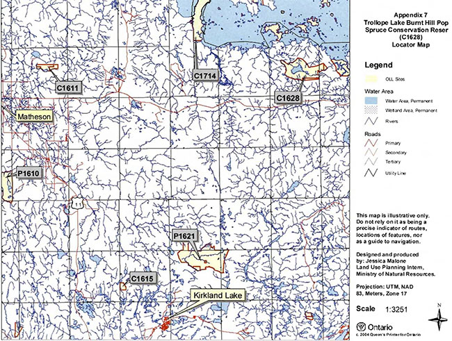
Enlarge Appendix 7 Trollope Lake Burnt Hill Pop Spruce Conservation Reser (C1628) Locator Map (PDF)
Appendix 8 Natural heritage - life science checksheet
Natural heritage area-life science checksheet
| Name | C1628 Trollope Lake Burnt Hill Poplar Spruce |
|---|---|
| Map name | Lightning River |
| Map number | 320-13 |
| UTM reference | 598538 |
| Locality | Cochrane |
| Latitude | 48° 34' 49" N |
| Longitude | 79° 40' 11" W |
| NAD | 83cnt |
| Minimum altitude | 280 m |
| Maximum altitude | 400 m |
| Township | Frecheville & Stoughton |
| Area | 2064 ha |
| Ownership | Crown |
| MNR region | Northeast |
| MNR district | Kirkland Lake |
| Ecoregion and ecodistrict | 3E-6 (Hills 1959; Crins 2000 |
| Landform unit(s) | N/A |
| Aerial photographs year- roll - flight line - numbers |
86-4819-12-191 to 194 86-4820-12-215 to 219 |
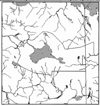
Physical and biological features
Representation
The Trollope Lake Burnt Hill Poplar Spruce Conservation Reserve is situated approximated 55 km northeast of the town of Kirkland Lake within Frecheville and Stoughton Townships and is in the jurisdiction of the Kirkland Lake MNR. The site is 2064 hectares and consists of mostly vectored boundaries with very few biological boundaries. The reserve can be accessed by means of a secondary road through the site from Highway 101. The conservation reserve was primarily designated based on its medium aged poplar and spruce on weakly broken bedrock and young/old poplar and medium aged spruce on lacustrine deposits. Some mixed forest stands and pure jack pines were also observed (OMNR 1999).
The site is located in Hills (1959) Lake Abitibi Site Region (3E) in the Site district of Kirkland Lake (3E-6). The Site Region or Ecoregion is characterized by stands of spruce, fir, poplar and birch on fresh sites on moderately sloping terrain. White and red pine trees occur on sand regions and elm and white cedar are found only in protected areas. The landform is typically flat to gently rolling, glacial clay and sandplain with local peatlands and wetlands. The landscape is broken throughout by glacial features such as moraines, eskers, kames and kettles. The forest climate type is mid-humid, mid-boreal (Poser 1992). Moderately broken plains of granitic and low-based bedrock with thin covers of sand and silty sand characterize the ecodistrict Several trains of glaciofluvial sand and gravel also occur (Hills 1959).
The reserve is found in the Northern Clay section (B.4) of Rowe’s (1972) Boreal Forest Region. The forests are found on widespread surface deposits of water-worked tills and lacustrine materials and on a fairly level topography, inherited from the glacial Lake Ojibway. Black spruce is the most common tree species of this section, covering gently rising uplands as well as the lowland flats. Spruce-cedar swamps occur in extensive areas where cedar only grows to tree size on swam edges.
Fine hardwood or mixedwood stands of trembling aspen, balsam poplar, balsam fir, white spruce and black spruce can be found in areas where improved drainage occur either by changes in relief or by shallowly buried coarse drift or beside rivers and lakes. Jack pine could be found on drier sites such as outwash deposits, old beaches and eskers.
The original gap analysis stated the main landforms from the provincial landform coverage were weakly broken bedrock, moderately broken bedrock and lacustrine deposits. Bedrock covers approximately 75% of the site with lacustrine deposits found on the tip of the west boundary and the rest on the east side (Map 1b). Need Rik’s interpretation. Lee (1977) also has the conservation reserve consisting mainly of bedrock ridges with ground moraine consisting of till as the subordinate landform. A small area on the east side consists of sandy/gravelly glaciofluvial deposits while on the west side it is a till/sand ground moraine. Portions of the south side and the extreme east side consists of clay, silty glaciolacustrine deposits.
Physiographically, the conservation reserve is situated on the Abitibi Uplands, a section of the James Region, a subdivision of the Shield. It is characterized by crystalline Archaen rocks and has broad rolling surfaces. Most of the uplands lie between 900 and 1200 feet elevation (Bostock 1970).
FRI data shows the site to be dominated by trembling aspen mixedwood (14.2%), white birch conifer dominant
A more ecological approach was taken to the FRI and the stands were reduced to SFU's (standard forest units). There were 9 SFU's on the site, the dominant ones being P01 (poplar), MW2 (spruce fir mixed), MW1 (jack pine mixed) and SP1 (spruce fir) and account for approximately 83% of the site (Map 2d, Appendix 2). Other SFU's were SB1 (black spruce lowland), PJ2 (pine spruce), PJ1 Uack pine), BW1 (birch poplar), and LC1 (lowland conifer).
Most of the stands were stocked at either 100% or 61-80% (Map 2b). Those areas with no stocking were either harvested sites as in east of the road or barren-and-scattered sites. These were considered as 'pure' species stands. Low stocking was associated with bedrock areas.
The majority of the stand is under the age of 90 (Map 2c). A few jack pine and cedar stands were between 90 and 119 years of age. The even distribution of the age groups suggest a natural disturbance occurred in the area. The 30-59 age class are located around the north and east shore of Trollope and Defoe Lakes and extending from the southcentral shore of Trollope Lake. The 60-89 age groups are located from the westcentral arm of the site to the west side of Trollope Lake, from southeast corner of Trollope Lake to the south site boundary and around to the east side of the site. There are no old growth stands in the site.
Wetlands
The conservation reserve is situated on two trapline areas (KL00S & LK012) and a bear management area (KL-28-009)(Map3a). Other values include a moose wintering area in the northcentral area of the site, moose aquatic feeding area in the creek at the northwest corner of Trollope Lake and a lake trout fisheries in Trollope area. This lake is used for winter fishing as indicated by the fishing huts on islands/shorelines observed during aerial reconnaissance. Wildlife observed include two moose in the semi-treed/treed bog northwest of Trollope Lake and a cormorant colony on a rock island in Trollope Lake (Burkhardt 2002).
The reserve is located in tertiary watershed 4MA of the Moose River Basin.
Condition
Condition is the amount of disturbance within a conservation reserve. In C1628, the disturbance is considered to be low.
Past natural disturbance include a forest fire in 1921 in the south portion of the site (Appendix 1) and possibly the Great Fire of 1911. Flooding has occurred at some of the creeks as a result of beaver activity.
Diversity
Diversity is the measure of the site’s life and earth science heterogeneity. It is based on the number and range (variety) of the natural landscape features and landforms of earth science values and the richness and evenness of the life science component. The original gap analysis at 3637 hectares had 43 landform:vegetation combinations based on the provincial landform coverage and different forest communities. The dominant combinations were medium aged poplar and spruce on weakly broken bedrock and young/old poplar and medium aged spruce on lacustrine deposits (Ritchie & Thompson 1997). Using the current area and same provincial landforms the combination was approximately 47, but this was using recent forest community classifications and not including wetlands. Once Rik Kristjannson’s earth science interpretation is complete a more accurate and realistic landform:vegetation combination can be obtained.
In reviewing the forest communities and wetlands present it appears diversity is moderately skewed
Ecological considerations
Whenever possible, a site’s boundaries should be created to include the greatest diversity of life and earth science features to provide the maximum ecological integrity. It should be ecologically self-contained, bounded by natural features and include adequate area to buffer the core ecosystems from adjacent land use activities (OMNR 1992). The Trollope Lake Burnt Hill Poplar Spruce conservation reserve has a very irregular shape and the boundaries are very vectored. With so many vector boundaries, it is difficult to determine exactly where the site lies without having to GPS and mark the whole site, thus running the risk of encroachment of adjacent land use activities. As well, with the vectors, many of the forest communities became fragmented and do very little to protect the core values. This also applies to the two arms on the west and east side. Its narrow configuration and fragmented forest communities offer little protection from adjacent land use activities and buffer capabilities to core values. If this site were a candidate for the Room to Grow program several modifications could be made. On the east side, the site could be extended to the secondary road. On the west arm, the trembling aspen and jack pine could be removed and the bog complex edge used instead. On the west side of the northcentral point the vector border could be extended to a natural line distinct on aerial photography between forest and bedrock. South of the site, the borders could be extended to harvested areas since little distinct biological features occur. Overall, this would make the reserve rounder and offer more protection to core values.
Currently we do not have minimum size standards for conservation reserves under different landscape conditions. However, a minimum size standard of 2000 hectares has been established for natural environmental parks by Ontario Parks (OMNR 1992). This minimum standard was necessary to protect representative landscapes as well as allow for low intensity recreational activities. The conservation reserve has 2064 hectares and just meets the minimum standard. Although it is over 2000 hectares in size, the configuration of the site with its vectored boundaries and irregular shape offers reduced protection for the representative landscapes.
Special features
This conservation reserve contained several interesting features. One was the even age distribution of forest communities suggesting a natural disturbance approximately 30-60 years ago in one area and 60-90 years ago in the other areas. The overall visual diversity of the site is interesting from all the bedrock exposure particularly Burnt Hill to the clear, brown-coloured Trollope and Defoe Lakes to the different wetlands to the rolling topography.
Major information sources
Arnup, R., G.D. Racey and R.E. Whaley. 1999. Training manual for photo interpretation of ecosites in northwestern Ontario. NWST Technical Manual TM-003.127p.
Bostick, H.S. 1970. Geology and Economic Minerals of Canada.
Burkhardt, B.C. 2002. Aerial Reconnaissance Notes C1628.
Crins, W.J. 2000. Ecoregions of Ontario: Modifications to Angus Hills' Site Regions and Site Districts Revisions and Rationale.
Hills, G.A. 1959. A Steady Reference to the Description of the Land of Ontario and its Productivity.
Lee, Hulbert A 1979. Northern Ontario Engineering Geology Terrain Study, Data Base Map, Abitibi. Ontario Geological Survey, Map 5028, Scale 1:100 000.
Ontario Ministry of Natural Resources. 1986 Aerial Photography 86-4819-12-191 to 194, 86-4820-12-215 to 219
Ontario Ministry of Natural Resources. Ontario Provincial Parks: Planning and Management Policies - 1992 Update
Ontario Ministry of Natural Resources. 2002. MNR Districts and Major Basins of Ontario.
Poser, S. 1992. Report on the Status of Provincial Parks in the Site Regions and Districts of Ontario. Ministry of Natural Resources Report.
Ritchie, Grant & J.E. Thompson. 1997. Lands for Life-Natural Heritage Reference Binder for the Boreal East Planning Area.
Rowe, J.S. 1972. Forest Regions of Canada. Department of Fisheries and the Environment-Canadian Forestry Service Publication No. 1300. 172 p.
Taylor, K.C., R.W. Arnupd B.G. Merchant, W.J. Parton and J. Nieppola. 2000. A field guide to forest ecosystems of northeastern Ontario. 2" Edition. Northeast Science and Technology NEST Field Guide FG-001.
Significance level (provincial/regional/local) and brief summary of major representative values
In the original gap analysis, the conservation reserve on 3637 hectares was dominated primarily by medium aged poplar and spruce on weakly broken bedrock, and young/old poplar and medium aged spruce on lacustrine deposits with some mixed forest stands and pure jack pine in the northern portion of the site. A total of 43 landform: vegetation combinations were determined. The reserve’s latest area was at 2064 hectares with the representative features remaining the same, if the provincial landforms are considered. Using SFU's and developmental stages as a more ecological approach, the site was dominated by mature (medium aged) poplar (P01), immature (young) spruce (SP1), immature spruce mixedwoods (MW2) and mature jack pine mixedwoods (MW1), consistent with the original gap analysis. Once Rik Kristjansson’s geological interpretation of the site becomes available, the significance will be revisited.
Sensitivity
The sensitive areas of the site include the number of creeks flowing into the site. Any development from the outside causing erosion or contamination to the waterways may have an affect to the waterways and/or wetlands within the site. Access from the secondary road into the site for the use of all-terrain vehicles for recreational hunting can be a concern. The lake trout population could be at risk with the cormorant population present and may have to be monitored.
Recommendations
- This first step checksheet should be advanced to a fourth step by digitizing the earth science data based on Kristjansson’s interpretations, once these become available and used with SFU and developmental stage data to complete a current landform: vegetation analysis. In addition, photos and sampling areas should be mapped and added to the checksheet. Finally, the checksheet could be advanced to a fifth step by comparing the fourth step checksheet with the current provincial landform layers based on the new regulated boundary to see if comparisons can be made. In turn we can determine more fully the site’s significance and contribution to the parks and protected areas program.
- Provincial landform data needs to be compared to Kritstjansson’s landform layers once they are completely available.
- The vectored boundaries for the site should be marked to ensure that the values within the site are protected from surrounding land use activities. Further analysis and assessment may require additional management prescription to ensure long term protection of the site’s natural heritage values.
- Funding should be secured in the near future to determine the number and location of roads and trails currently present within the site using current global positioning technologies.
- Any future economic or development proposals should go through a test of compatibility.
- Any future trail development must consider the values found within the boundaries of the site, the rationale for developing trails within the site and the availability of current access through the site and surrounding areas. Furthermore, any new trail development will require a 'Test of Compatibility'. Low-lying areas and wetlands should be avoided.
- Overall custodial management is the responsibility of the district office with support from the regional natural heritage specialist and Ontario Parks. To advance conservation reserve custodial management, future managers will need to monitor the current state of the CRs resources at least at the community and landscape levels within and adjacent to the conservation reserve and its surrounding environment. Such monitoring could include: evaluating and reporting on changes such as; natural disturbances (ie. fire, insect/disease, wind throw, etc.), human disturbances (ie. forest harvesting, access and/or other land use activities) as well as management prescriptions (ie. rehabilitation efforts and/or vegetative management planning).
- Ongoing evaluations and reports will have to rely on current and new technologies such as satellite imagery, global positioning systems (GPS), supplementary aerial photography (SAP) and/or aerial/ground reconnaissance surveys/assessments conducted periodically and placed within a GIS database. Such tools could help managers spatially record areas affected, severity of perturbations or management action as well as consider the sensitivity of values, the design of CR and determine the future desired condition of the site. Monitoring efficiencies could be enhanced via partnerships and internal coordination within MNR.
footnote 7
Time effort spent on site
September 6, 2002 11:00- 12:00
Date compiled
May 23,2003
Compiler(s)
Barbara Burkhardt, Lori King, Sean Longyear
Cl628 Trollope Lake Burnt Hill Poplar Spruce CR, landforms
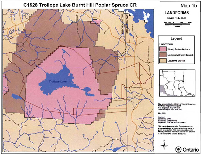
Enlarge Cl628 Trollope Lake Burnt Hill Poplar Spruce CR, landforms (PDF)
Cl628 Trollope Lake Burnt Hill Poplar Spruce CR, forest communities
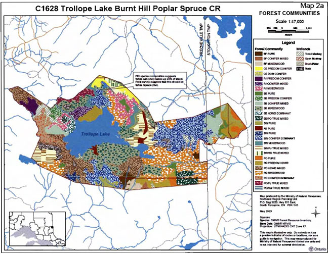
Enlarge Cl628 Trollope Lake Burnt Hill Poplar Spruce Conservation Reserves, forest communities (PDF)
Cl628 Trollope Lake Burnt Hill Poplar Spruce CR, stocking distribution
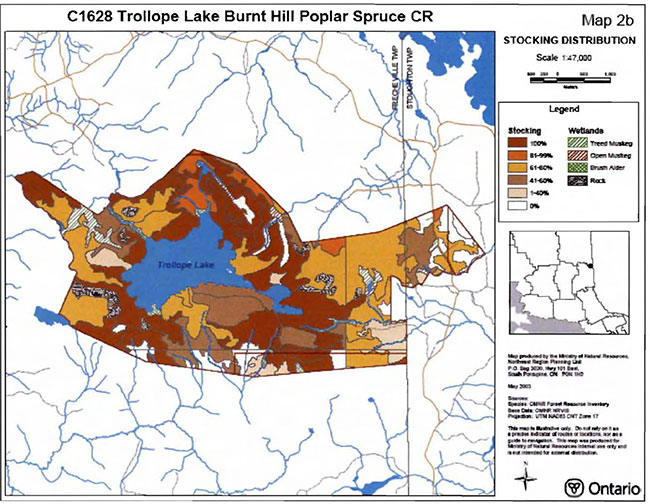
Cl628 Trollope Lake Burnt Hill Poplar Spruce CR, age distribution
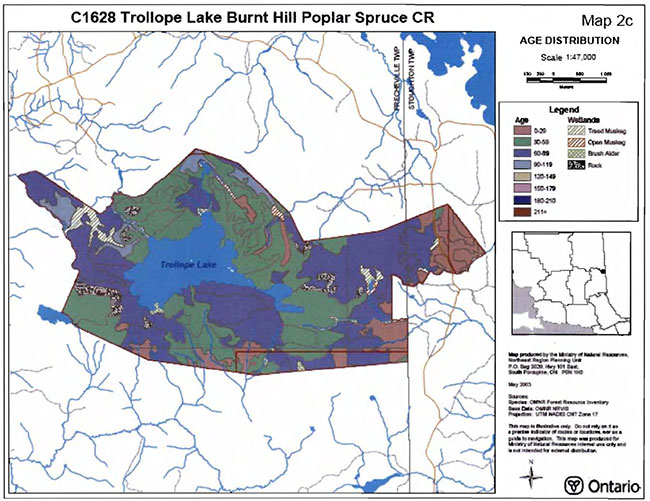
Enlarge Cl628 Trollope Lake Burnt Hill Poplar Spruce Conservation Reserves, age distribution (PDF)
Cl628 Trollope Lake Burnt Hill Poplar Spruce CR, standard forest units
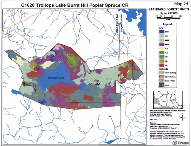
Cl628 Trollope Lake Burnt Hill Poplar Spruce CR, values
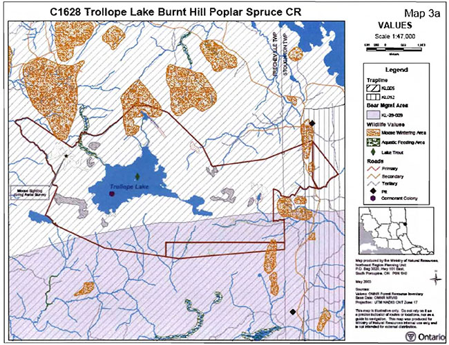
Enlarge nits Cl628 Trollope Lake Burnt Hill Poplar Spruce Conservation Reserves, values (PDF)
Cl628 Trollope Lake Burnt Hill Poplar Spruce CR, wetlands
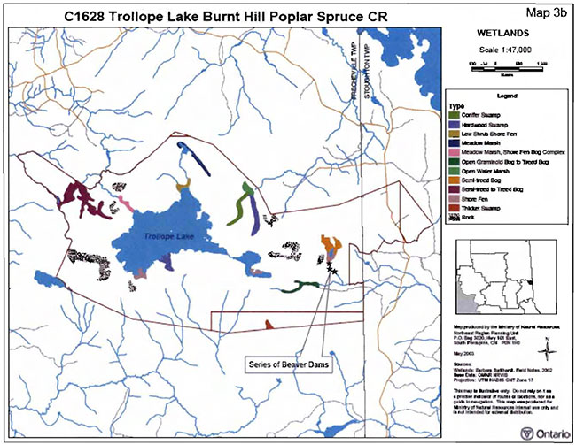
Enlarge Cl628 Trollope Lake Burnt Hill Poplar Spruce Conservation Reserves, wetlands (PDF)
Cl628 Trollope Lake Burnt Hill Poplar Spruce CR, old growth
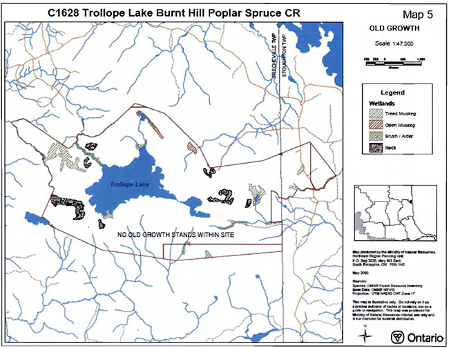
Enlarge Cl628 Trollope Lake Burnt Hill Poplar Spruce Conservation Reserves, old growth (PDF)
Cl628 Trollope Lake Burnt Hill Poplar Spruce CR, fire disturbance
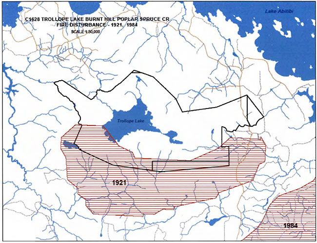
Enlarge Cl628 Trollope Lake Burnt Hill Poplar Spruce Conservation Reserves, fire disturbance (PDF)
Cl628 Trollope Lake Burnt Hill Poplar Spruce CR, geology and forest communities
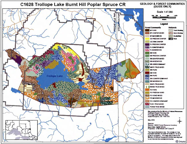
Cl628 Trollope Lake Burnt Hill Poplar Spruce CR, history

Enlarge Cl628 Trollope Lake Burnt Hill Poplar Spruce Conservation Reserves, History (PDF)
Plan of Cl628 Trollope Lake Burnt Hill Poplar Spruce CR
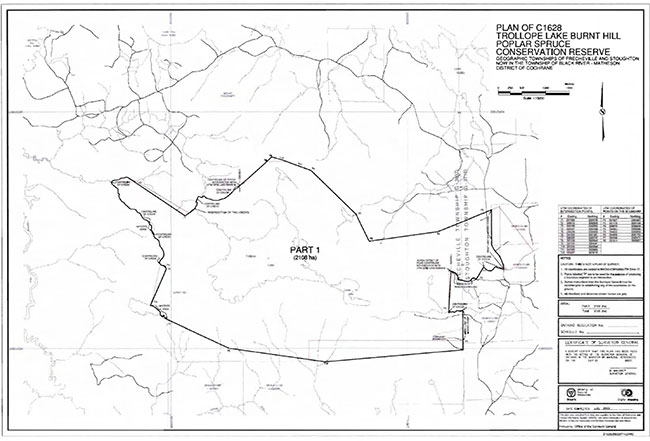
Enlarge Plan of Cl628 Trollope Lake Burnt Hill Poplar Spruce Conservation Reserves (PDF)
Cl628 Trollope Lake Burnt Hill Poplar Spruce CR, road access map
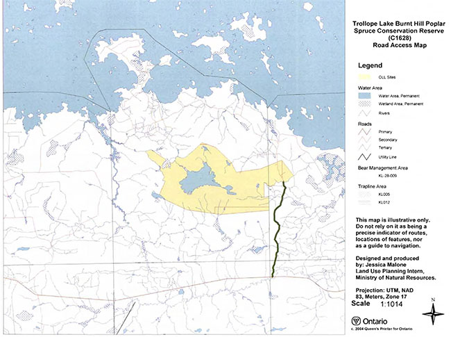
Enlarge Cl628 Trollope Lake Burnt Hill Poplar Spruce Conservation Reserves, road access map (PDF)
Cl628 Trollope Lake Burnt Hill Poplar Spruce CR, working copy
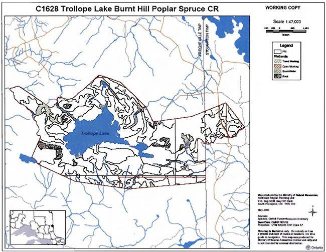
Enlarge Cl628 Trollope Lake Burnt Hill Poplar Spruce Conservation Reserves, working copy (PDF)
Appendix 9 Earth science checksheet
Draft earth science inventory checklist
Name: Trollope Lake Burnt Hill Poplar Spruce (Cl628)
Map name:
NTS number:
UTM ref. (datum):
Latitude:
Longitude: elevation (min):
Elevation (max):
Locality:
Township:
Area (ha):
Ownership:
MNR region:
MNR district:
Aerial photographs:
86-12, 4820, 214 to 220
86-12,4819, 190to 194
Prepared by:
F.J. (Rik) Kristjansson, Consulting Geoscientist
Reviewed by:
Phil Kor, Senior Conservation Geologist
Date: June, 2003
Earth science features
Bedrock Geology: Based on Map 2543 (Ontario Geological Survey, 1991), the Trollope Lake Burnt Hill Poplar Spruce Conservation Reserve is underlain by mafic to intermediate, metavolcanic rocks of the Abitibi Subprovince, Superior Province, Precambrian Shield.
Surficial Geology: Based on a brief helicopter reconnaissance survey, review of terrain geological mapping (Lee, 1979, Data Base Map 5028), review of surficial geological mapping (Vagners and Courtney, 1985, Map P.2734), and review of relatively recent aerial photography (1986), the Trollope Lake Burnt Hill Poplar Spruce Conservation Reserve appears to be immediately underlain by areas of Bedrock Outcrop (Unit 1), Bedrock-Drift Complex (Units 2ac and 2), Ice-Contact Stratified Drift Deposits (Unit 4), Glaciolacustrine Deposits (Units 6b and 6c), and Organic Deposits (Units 9 and 9/6b). Please refer to the attached aerial photographic interpretation for the occurrence and distribution of these surficial geological units within the conservation reserve (Appendix A).
Bedrock terrain dominates the surficial geology of this conservation reserve. The morphology of the bedrock surface within the conservation reserve is dominated by bedrock knob (or knoll) forms. An extensive area of bedrock terrain, which essentially encircles Trollope Lake and Defoe Lake, represents a complex of Bedrock Outcrop (Unit 1) and Bedrock-Drift Complex (Units 2ac and 2). Major areas of bedrock outcrop (>75% bedrock exposure is estimated) and thin, discontinuous till are anticipated within areas of Bedrock Outcrop (Unit 1). Moderate bedrock exposure associated with a discontinuous cover of till is expected within areas of Bedrock-Drift Complex (Unit 2ac). Within areas of Bedrock-Drift Complex classified as Unit 2, moderate bedrock exposure associated with a discontinuous cover of till and/or glaciolacustrine sediment is anticipated. In addition, several minor areas of Bedrock Outcrop (Unit 1) and Bedrock-Drift Complex (Unit 2) are located within the southeast, southwest, and northwest quadrants of the conservation reserve. The drift cover associated with these minor areas of bedrock terrain consists oftill and/or glaciolacustrine sediment.
It should be noted that the thin, discontinuous and discontinuous deposits of till associated with the various areas of bedrock terrain are composed of silty sand till (Vagners and Courtney, 1985, Map P.2734). Moreover, this silty sand till is "referred to informally as the Matheson formation (Hughes 1959), while Skinner (1973) named its stratigraphic equivalent in the Moose River Basin the Adam Till".
An area of Ice-Contact Stratified Drift Deposits (Unit 4) is located in the northeast part of the conservation reserve. It is probable that these deposits were emplaced as a subaquatic outwash fan during the Angliers Phase of glacial Lake Ojibway (Vagners and Courtney, 1985, Map P.2734; and Vincent and Hardy, 1979). Vagners and Courtney (1985, Map P.2734) indicate that these deposits are overlain by a veneer of glaciolacustrine sediment.
A vast glaciolacustrine plain dominates the region surrounding the conservation reserve. Portions of this glaciolacustrine plain, which is largely underlain by glaciolacustrine silt and clay, have been encompassed by the conservation reserve. Areas immediately underlain by fine-grained, Glaciolacustrine Deposits (Unit 6b) are located in the south central, southeast, central east, extreme northeast, and extreme northwest parts of the conservation reserve. During the helicopter reconnaissance survey, a brief landing was made within a "cut over" area to obtain some additional information concerning these fine-grained, glaciolacustrine sediments. At the landing location, a short distance to the south of the south central part of the conservation reserve, a hand auger hole revealed at least 0.7 metres of silty clay (to clayey silt). Vagners and Courtney (1985, Map P.2734) indicate that areas immediately underlain by coarse-grained, glaciolacustrine deposits (i.e., "sand with minor gravel") could have originated "from the reworking of till … in the high energy nearshore zone as the glacial lake level fell". A small area of coarse-grained, Glaciolacustrine Deposits (Unit 6c) appears to be present in the northwest part of the conservation reserve.
Various areas immediately underlain by organic deposits are present within the conservation reserve. Several relatively extensive areas of Organic Deposits (Unit 9) are located in the northwest, north central, and central east parts of the conservation reserve. Finally, an area of Organic Deposits (Unit 9/6b), which occurs predominantly as a veneer overlying fine-grained, glaciolacustrine deposits (Vagners and Courtney, 1985, Map P.2734), is located in the extreme south central part of the conservation reserve.
Significance: The geological features described above are commonly encountered within this region, and are considered to be of local significance.
Sensitivity: Considering the relatively passive land uses anticipated within a conservation reserve (e.g., hunting), the various features are considered to have low sensitivity.
Recommendations: None
References:
Hughes, O.L., 1959; Surficial Geology of Smooth Rock and Iroquois Falls Map Areas, Cochrane District, Ontario; Ph.D. Thesis, University of Kansas, Lawrence, Kansas, 190 p.
Lee, H.A., 1979; Northern Ontario Engineering Geology Terrain Study, Data Base Map, Abitibi; Ontario Geological Survey, Map 5028, Scale 1:100,000.
Ontario Geological Survey, 1991; Bedrock Geology of Ontario, East-Central Sheet; Ontario Geological Survey, Map 2543, Scale 1:1,000,000.
Skinner, R.G., 1973; Quaternary Stratigraphy of the Moose River Basin, Ontario; Geological Survey of Canada, Bulletin 225, 77 p., 6 plans and sections.
Vagners, U.J. and Courtney, S.J., 1985; Quaternary Geology of the Lightning River Area, District of Cochrane; Ontario Geological Survey, Geological Series - Preliminary Map P.2734, Scale 1:50,000. Geology 1983.
Vincent, J.S. and Hardy, L., 1979; The Evolution of glacial Lakes Barlow and Ojibway, Quebec and Ontario; Geological Survey of Canada, Bulletin 316, 18p.
Photographs:
Appendices: Preliminary Surficial Geology of the Trollope Lake Burnt Hill Poplar Spruce Conservation Reserve (C1628)
Footnotes
- footnote[1] Back to paragraph Vector — A straight line in space characterized mathematically by its direction and magnitude. It is used in GIS work to create a file of points such that vectors can be drawn from point to point to portray line segments.
- footnote[2] Back to paragraph Conifer stands are defined as follows: pure conifer stands contain 100% of a conifer trees in the canopy; dominant conifer stands contain less than 10% cover of hardwoods in the main canopy and predominant conifer stands contain less than 20% cover of hardwoods in the main canopy. Similarly hardwood stands may contain no conifer in canopy (pure hardwood), less than 10% conifer (dominant hardwood) or less than 20% conifer cover (predominant hardwood) (modified after Taylor et al 2000).
- footnote[3] Back to paragraph Some modifications were made to Taylor et al (2000). Hardwood conifer dominated stands are defined as a stand with hardwood working group but total conifer species is greater than hardwood (eg. Bw4Bf3Sw2Ce1). Similarly a conifer hardwood dominated stand is a stand with a conifer working group species but total hardwood species is greater than conifer (eg. Sb3Bw3Po3Bf1).
- footnote[ 1] Back to paragraph Mixedwoods are defined as follows: hardwood mixedwoods are stands dominated by hardwoods with less than 30% cover of conifer in the main canopy; similarly conifer mixedwoods contain less than 30% hardwoods in the canopy. Mixedwoods contain approximately equal percentages of conifer and hardwood trees and true mixedwoods contain a 50:50 split between conifers and hardwoods (modified after Taylor et al 2000).
- footnote[4] Back to paragraph Wetlands were classified after Arnup et al. 1999
- footnote[5] Back to paragraph Rating based on the amount of area currently under some form of known disturbance. High is >20% of the area, medium 10 to 20%, low < 10% and pristine < 1%.
- footnote[6] Back to paragraph Evenness of the site defined as strongly skewed (top 3 communities capture >=60% of the site in area), moderately skewed (30-59%) or slightly skewed to even (<30%).
- footnote[7] Back to paragraph Coordination could include a variety of expertise from the following: Field Services Division, Ontario Parks, Aviation and Forest Fire Management Branch, Forest Health and Silvicultural and Forest Management Planning Sections, Northeast Science and Information etc. Additional expertise within and outside the MNR could be sought as required.