Turkey Point Provincial Park Management Plan
This document provides policy direction for the protection, development and management of Turkey Point Provincial Park and its resources.
Approval statement
We are pleased to approve the Turkey Point Provincial Park Management Plan as official policy for the management and development of this park. The plan reflects this Ministry’s intent to protect the cultural, natural and recreational features of Turkey Point Provincial Park and maintain high quality opportunities for outdoor recreation and heritage appreciation for both residents of Ontario and visitors to the Province.
Signed by:
David J. Johnstone
Regional Director
Southwestern Region
N. R. Richards
Director, Parks and
Recreational Areas Branch
1.0 Introduction
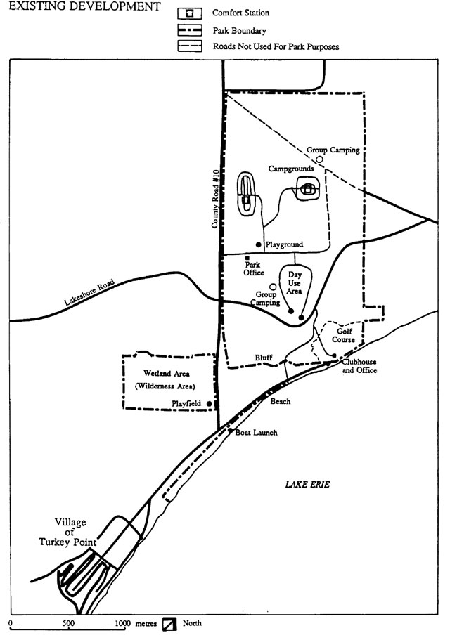
Turkey Point Provincial Park was established in 1959 by regulation 70/59 under the Provincial Parks Act. Consisting primarily of Crown Land that was once part of the St. Williams Forestry Station, the 311 hectare (ha) park is broken into 3 parcels: the main area located on top of a bluff overlooking Lake Erie (264 ha); the beach (10 ha); and the wetland area (37 ha).
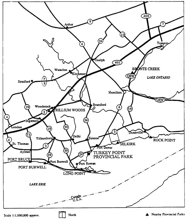
The park is located on the north shore of Lake Erie immediately north of Long Point peninsula (Figure 1). It borders Long Point Bay, where excellent boating, fishing and hunting can be enjoyed. The towns of Delhi Tillsonburg and Simcoe are nearby; Southern Ontario’s largest population centres, including Metropolitan Toronto, are within a 2 hour drive.
Included w ithin the park are 195 campsites, a picnicking area, a group campground, and a sand beach, which is located 1 km from the campground, adjacent to the Village of Turkey Point (Figure 2). Also included is a nine-hole public golf course, operated by a contractor under an agreement with the Ministry of Natural Resources.
A number of natural and cultural features contribute to the park’s significance. These include provincially significant vegetation types, rare and endangered species, and archaeological sites.
2.0 Classification
Turkey Point Provincial Park is classified as a Recreation Class park because it supports a wide variety of outdoor recreation opportunities for large numbers of people in attractive surroundings. The park also contains significant natural and cultural features, which will be recognized and protected.
3.0 Goal
To provide a variety of recreation opportunities which utilize the natural and cultural resources of the park, while protecting significant ecological and archaeological features.
4.0 Objectives
Turkey Point Provincial Park contributes towards meeting the objectives of the provincial park system.
4.1 Protection
To protect provincially significant elements of the natural and cultural landscape of Ontario.
The park contains provincially and regionally significant plant communities, a number of rare plant species, and habitat for one endangered species (Section 6.1). Surveys have also noted the existence of archaeological sites (Section 6.4). These features will be protected through appropriate zoning and management
4.2 Recreation
To provide a range of facility based outdoor recreation opportunities.
Opportunities for a wide variety of recreation activities, such as camping, picnicking, sunbathing, swimming and golfing, will be provided at Turkey Point Provincial Park. Low intensity activities such as walking and nature viewing will also be encouraged. Recreation activities will be enhanced through improvements to park facilities and appropriate management.
4.3 Heritage appreciation
To provide opportunities for the exploration and appreciation of the outdoor natural and cultural heritage of Ontario.
The large oaks and pines that dominate the park’s natural landscape represent the forest that once existed over much of the surrounding Norfolk Sand Plain. The nearby St. Williams Forestry Station played a crucial role in promoting soil conservation practices after the natural forest cover was removed. Similarly, the Normandale Fish Culture Station contributes to the effective management of fisheries throughout the region. These elements make the park an appropriate location to interpret and develop an understanding of man’s interactions with the environment (Section 8.2).
4.4 Tourism
To provide Ontario’s residents and out-of-province visitors with opportunities to discover and experience the distinctive regions of the province.
Turkey Point Provincial Park, along with nearby Long Point Provincial Park, are adjacent to Long Point Bay, an internationally significant resource providing opportunities for boating, fishing, hunting, and nature-viewing. This resource attracts many visitors to the area, and use of the park as an alternative to heavily used Long Point Provincial Park will be encouraged.
By attracting over 100,000 visitors annually, the park makes a significant contribution to the local and provincial economies. Management of the park will be aimed at maintaining and increasing this contribution. Information relating to local attraction and events will be made available to park visitors, in order to support the local tourist industry.
5.0 Park boundary
Presently the park’s boundary does not include all of the Crown beach that fronts the Village of Turkey Point. In order to encourage more orderly use of this portion of the beach, it is proposed to be incorporated into the park through an amendment to the park’s regulations.
The wetland area has, up until now, been designated as a Wilderness Area under the Wilderness Areas Act. With the proposed designation as a nature reserve zone, the protection afforded by the Wilderness Areas Act is no longer necessary. Therefore, it is proposed that the areas designation under the Wilderness Area Act be rescinded.
6.0 Zoning
Four zones will be designated to guide the management and development of the park, and to protect natural and cultural features (Figure 3).
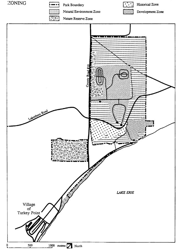
6.1 Nature reserve zone (49 ha)
Turkey Point Provincial Park is in the Carolinian Floristic Zone of the Deciduous Forest Region (Hills’ Site District 7-2); a number of vegetation types and individual species found in the park are considered provincially or regionally significant. In order to protect these natural features, major portions of oak-pine forest, oak savannah, and dry sand prairie vegetation types will be incorporated in the nature reserve zone. The wetland area, which itself contains significant plant communities such as a relict black spruce bog, will also be included in this zone.
Management of the nature reserve zone will be aimed at protecting the vegetation and wildlife. Use will be limited to walking and nature viewing. Inventories have shown that parts of the oak savannah are succeeding to a more closed oak-pine forest In order to preserve the savannah and the prairie species that flourish, management by prescribed burning may be undertaken. Should research demonstrate the need, the wetland area may be actively managed to protect the habitat of the endangered species. A vegetation management plan will guide all vegetation management undertaken in the park including the nature reserve zone.
6.2 Development zone (97 ha)
Developed and intensively used portions of the park, such as the campground, picnic area, beach, and golf course, will be included in the development zone. Management will emphasize public safety and enjoyment, while preserving the natural character of the park setting.
No development will occur immediately adjacent to the two historic cairns in the Development Zone. The first, located at the entrance to the golf course, will be maintained to commemorate the location of Fort Norfolk. The second cairn, located in the park’s day use area on property once associated with St. Williams Forest Station, will also be maintained unless the Forest Station should wish to have the plaque portion relocated to a site within the present day station complex. If this should occur, the remainder of the cairn would be removed from the site.
6.3 Natural environment zone (145 ha)
Much of the park will be designated as a natural environment zone to maintain the natural landscape, provide buffer areas for more intensive uses and protect sensitive areas from use. Extensive conifer plantations are included within this zone. These plantations will be managed to encourage regeneration of more natural plant communities; severe thinning will be necessary in many instances, and prescribed burning may be used as a management tool.
The steep, sandy bluff is within the natural environment zone. Measures will be taken to minimize human impact on the slope, and to protect the feature from erosion.
Walking trails may be developed and operated in this zone; no other development will be undertaken.
6.4 Historical zone (20 ha)
Archaeological investigations have revealed a number of historical sites of aboriginal and post-European origin within the park. These sites are concentrated in an area adjacent to the bluff, and will be included in the historical zone. Development will be limited to trail construction. Conifer plantations within the zone may be managed (Section 6.3), although fire will not be used as a management tool in this zone. Techniques will be chosen which do not disturb the soil surface, so that archaeological sites are protected. The Ministry of Culture and Communications will be advised prior to any work being undertaken in proximity to known archaeological features.
7.0 Resource management
7.1 Landform management
Forming part of the Norfolk Sand Plain, the soils within the park are sandy, and consequently subject to wind and water erosion. The bluff, which is most sensitive to erosion, will be protected against loss of vegetative cover, and disturbed areas will be planted to reduce erosion.
No erosion protection will be undertaken on the beach, unless erosion poses a danger to life or property, in which case action will be considered in concert with the Long Point Region Conservation Authority and municipal agencies.
7.2 Vegetation management
Vegetation management will be directed by a vegetation management plan, which will provide details of the measures described below, and others discussed in Sections 6.1 to 6.4.
Native insects and diseases that attack vegetation in the park will normally be allowed to develop undisturbed. However, those insects and diseases which threaten values within the park for which the park has been established, aesthetic values within the Development Zones or values outside the park will be controlled where appropriate. Insects and diseases not native will be controlled where feasible and necessary. Where control is undertaken, it will be directed as narrowly as possible to the specific insect or disease so as to have minimal effects on other components of the park’s environment. Attempts will be made to prevent insects introduction into the park and to eliminate them before they become established. Biological control will be used wherever practicable. The use of chemicals within the Development Zones to control, protect or promote vegetation will be kept to the absolute minimum and used only if alternative methods are not feasible. The use of chemicals outside the Development Zones will not occur unless required under exceptional circumstances.
The nature reserve zone will be managed to protect naturally occurring vegetation. Controlled burning may be used to perpetrate oak savannah, and special measures may be undertaken to protect the habitat of the endangered species found in the wetland area.
Within the natural environment zone, plantations will be thinned to encourage the development of more natural plant communities; controlled burning may be used as a management technique.
Management of the development zone will be aimed at providing a safe, attractive environment for recreational use. Trees may be removed to encourage the growth of ground cover and buffer vegetation. Poison ivy grows vigorously in the park; control will be undertaken on and adjacent to campsites, roads, trails, and play areas. Hazardous trees will be removed.
No controlled burning will take place within the historical zone or the development zone. Native species will be planted in all zones where planting is undertaken.
7.3 Wildlife management
Should the need for specific wildlife management measures be identified, then such measures will be incorporated in the vegetation management plan, or, if warranted, a wildlife management plan may be written.
Hunting will not be permitted within the park. Regulations under the Game and Fish Act will allow visitors to possess firearms, so that they may use lands within the park to gain access to hunting opportunities in Long Point Bay.
8.0 Operations
A Park Operations Plan will be prepared to provide park staff with the information required to operate the park on a day-to-day basis. The provisions of the plan will be consistent with the approved Ontario Provincial Parks Operating Standards, and will be reviewed annually and updated as necessary.
8.1 Visitor services
8.1.1 Information
Park visitors will be provided with information regarding not only park activities and Ministry programs, but also local events, services, and attractions. The latter includes the nearby St. Williams Forestry Station and the Normandale Fish Culture Station. This will be done through the use of displays at the park office and bulletin boards at other park locations.
8.1.2 Interpretation
Interpretation of the park’s natural and cultural values will be achieved through programs organized by staff and through self-serve facilities, such as trails. The main theme will be man and his use of the landscape through the years. Minor themes will include forest ecology, wetland succession, forest management, and historical resources. The park will be available for use by educational groups, but no specific educational program will be offered.
8.1.3 Recreation
In recognition of the classification of Turkey Point Provincial Park as a recreation class park, visitors will be offered a variety of recreational activities. Staff will organize activities such as sing-alongs and special events; unorganized recreation will be encouraged by providing facilities and equipment.
Communications, interpretation and recreation activities will be planned and directed through a visitor services plan.
8.2 Research
Research may be carried out according to Ministry policies.
Areas of particular interest are: the ecology of the oak-pine forest and oak-savannah; long term impacts of prescribed burning; habitat requirements of rare and endangered plant and animal species; and wildlife inventories.
8.3 Marketing
Although the beach is heavily used, campgrounds do not receive optimal use. During 1988 the July-August campsite occupancy rate was 41%. A number of steps will be taken to increase use. When nearby Long Point Provincial Park is full, visitors will be encouraged to use Turkey Point Marketing efforts will concentrate on attracting family groups from the Hamilton, Kitchener-Waterloo, and Cambridge regions, for extended stays in the park.
A marketing plan will direct these efforts.
8.4 Enforcement
The enforcement program will be carried out according to Ministry policies and the Simcoe District enforcement plan, in order to provide for the safety of visitors and the protection of resources and facilities. Offshore boating will be restricted in swimming areas through Boating Restriction Regulations under the Canada Shipping Act.
9.0 Development
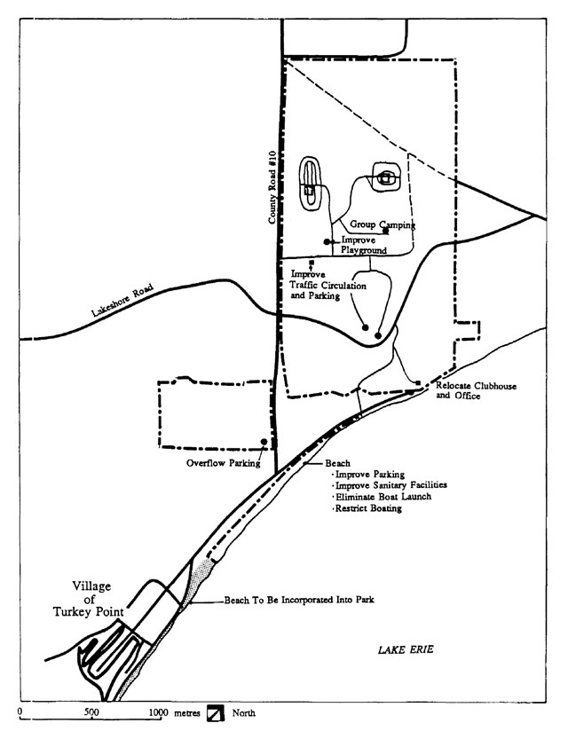
9.1 Beach
Heavy use of the beach causes traffic and parking problems, compromises public safety, and adversely affects adjacent landowners. Measures will be undertaken to improve conditions and control overcrowding.
Parking will be confined by traffic barriers, and vehicular access will be limited to 3 or 4 locations. The playfield adjacent to Regional Road No. 10 may be used for overflow parking. Parking areas will also be established at other beach access points south of the main beach. Sanitary facilities will be improved throughout and drinking water will be supplied at the main beach. The present boat launch will be eliminated in consideration of public safety.
Once development and improvements are sufficiently completed, daily vehicle fees will be collected during periods of heavy use.
9.2 Campground
Expansion of the 195 unit campground will not be undertaken; campsites will be improved and a maximum of 50 will be equipped with electrical outlets.
Should increased use necessitate campground expansion, there is space within the development zone for up to 150 additional campsites.
9.3 Golf course
The golf course will be retained, and will continue to be operated under contract. Due to its location close to the steep (30 m high) bluff, the clubhouse-office complex will be moved and the building reconstructed on an alternate location. In addition, the parking lot will be upgraded and improved.
9.4 Other facilities
Roads that are not required for park operations will not he maintained by the Ministry. All two-way roads within the camping area will receive a tar and chip surface, in order to reduce annual maintenance costs.
The playground may be expanded to ensure that it is of interest to children of various ages. The existing Lookout Bluff Trail will be improved, and additional trails will be developed around the periphery of the park, to encourage visitors to observe forest succession and vegetation management.
10.0 Implementation
This plan provides guidance for the management of the park for the next 20 years. Review of the plan will be undertaken at least once every 10 years, or as required. Discrete components of the plan are listed below in order of priority.
- regulate offshore boating.
- implement the vegetation management plan (published 1986).
- incorporate Crown beach into park.
- improve beach sanitary facilities.
- improve beach parking.
- increase electrical campsites to 50.
- develop a marketing plan.
- develop a visitor services plan.
- improve playground.
- surface two-way campground roads.
- recommend Wilderness Areas Act designation be rescinded.
- improve golf course parking.
- reconstruct golf course clubhouse-office.
11.0 Summary of public consultation
The management planning process for Turkey Point Provincial Park commenced in 1974, when information packages were distributed and informal meetings were held with various interest groups. Public comments were solicited and were incorporated in a preliminary management plan.
In 1980, the Turkey Point Provincial Park Preliminary Master Plan was published and distributed for public comment. The preliminary plan formed the basis for this approved management plan.
12.0 Selected references
Baker, J.A. 1974. General ecological assessment and park zone synthesis of Turkey Point Provincial Park. Ontario Ministry of Natural Resources (O.M.N.R.) unpublished technical report, Simcoe District, Simcoe.
Baker, J.A. 1974. Ecological inventory: a synthesis of ecological information on Turkey Point Provincial Park. O.M.N.R. unpublished technical report, Simcoe District, Simcoe.
Harvey, L., N. Helling, M. Schreiber, and O. Lichtenfeld. 1971. Turkey Point Provincial Park ecological survey. O.M.N.R. unpublished technical report, Simcoe District, Simcoe.
Hills, G.A. 1959. Site regions and site districts of Ontario. A map published by O.M.N.R., Research Branch, Queen’s Park, Toronto.
Mander, S. and A. Willock. 1974. A 1974 report on the visitor use survey for Turkey Point Provincial Park. O.M.N.R. unpublished technical report, Simcoe District, Simcoe.
Melvor, M.P. 1975. Turkey Point Provincial Park, Fort Norfolk, Charlotteville, and the War of 1812. Ontario Ministry of Culture and Recreation, Historical Planning and Research Branch, Toronto.
O.M.N.R. 1973-84. Ontario Provincial Parks Statistics. Queen’s Park, Toronto.
O.M.N.R. 1978. Ontario Provincial Parks Planning and Management Policies. Queen’s Park, Toronto.
O.M.N.R. 1983. Simcoe District Land Use Guidelines. Simcoe District, Simcoe. 57 p.
Radford, B. 1974. A synthesis of major historical themes of Turkey Point Provincial Park. O.M.N.R. unpublished technical report, Simcoe District, Simcoe.
Stothers, D.M. 1975. A preliminary report on an archaeological survey of Turkey Point Provincial Park. O.M.N.R. unpublished technical report, Simcoe District, Simcoe.
Thompson, R. 1975. Information package for alternative concepts, Turkey Point Provincial Park. O.M.N.R. unpublished report, Simcoe District, Simcoe.
Thompson, R. 1974. Public information booklet, a new direction for Turkey Point Provincial Park. O.M.N.R. unpublished report, Simcoe District, Simcoe.
Thompson, R. 1974. Issues and solutions summary booklet, a new direction for Turkey Point Provincial Park. O.M.N.R. unpublished report, Simcoe District, Simcoe.
Thompson, R. 1974. Issues and solutions summary booklet, a new direction for Turkey Point Provincial Park. O.M.N.R. unpublished report, Simcoe District, Simcoe.
Warren, W.D. 1974. Turkey Point Provincial Park, environmental planning series, earth science report. O.M.N.R., Park Planning Branch, Toronto.
Woolsey, G.B. 1971. An historical survey of Turkey Point from earliest Indian visitations to 1816. O.M.N.R. unpublished technical report, Simcoe District, Simcoe.
Wright, PJ. 1976. The 1975 archaeological survey of Turkey Point Provincial Park. Ontario Ministry of Culture and Recreation, Historical Planning and Research Branch, Toronto.