Understanding Stormwater Management: An Introduction to Stormwater Management Planning and Design
Major concepts and environmental concerns to consider in the Ministry of the Environment’s Stormwater Management Planning and Design Manual 2003.
Acknowledgements
We gratefully acknowledge the photographs and diagrams from the following sources:
Center for Watershed Protection (CWP). 2001. Impacts of Urbanization Watershed Leadership Kit, Volume 4 (CD format).
Center for Watershed Protection (CWP). 1999. Approaches to the Impacts of Urbanization: Watershed Leadership Kit Volume 2 (CD format).
Ministry of the Environment (MOE). 2003. Stormwater Management Planning and Design Manual 2003. Prepared by Aquafor Beech Ltd. and Marshall Macklin Monaghan Ltd.
Ministry of the Environment (MOE), Environment Canada (EC), Toronto and Region Conservation Authority (TRCA) et al. 2001. Stormwater Pollution Prevention Handbook. Prepared by Totten Sims Hubicki Associates, Donald G. Weatherbe Associates, and Elizabeth Leedham.
Understanding stormwater management: an introduction to stormwater management planning and design
What is the purpose of this publication?
This "stormwater primer" is intended to foster an appreciation of the environmental concerns associated with stormwater and the work done by stormwater management practitioners. The purpose of the publication is to introduce some of the major concepts contained in the Ministry of the Environment’s Stormwater Management Planning and Design Manual 2003.
What is stormwater?
Urban stormwater is rainfall and snowmelt that seeps into the ground or runs off the land into storm sewers, streams and lakes. It may also include runoff from activities such as watering lawns, washing cars and draining pools.
What is the hydrologic cycle?
The hydrologic cycle describes the continuous circulation of water between the oceans, atmosphere and land. Water is supplied to the atmosphere by evaporation from water and other surfaces, and transpiration from plants. It is returned to the land through precipitation. Within the land phase of the hydrologic cycle, water is stored by vegetation, snowpacks, land surfaces, water bodies and subsurface soils. Water is transported between these storage compartments via overland runoff, streamflow, infiltration, groundwater recharge, groundwater flow and groundwater discharge, among other processes (Figure 1).
Figure 1: hydrologic cycle
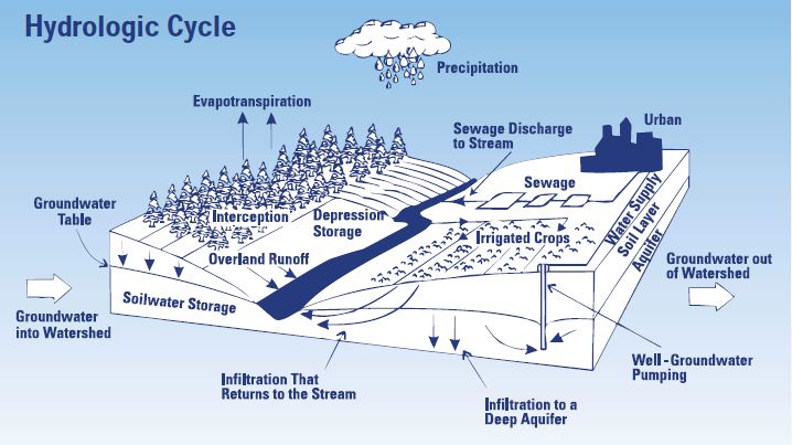
Source: After, M. L. Davis, and Cornwell, D.A. Introduction to Environmental Engineering, 1991
Definitions:
- Overland Runoff
- Water that travels over the ground surface to the channel.
- Stream flow
- Movement of water via channels
- Groundwater flow
- Movement of water through the subsurface
- Infiltration
- Penetration of water through the ground surface
- Groundwater recharge
- Water that reaches saturated zone
How does development affect the hydrologic cycle?
Humans interact with the hydrologic cycle by extracting water for agricultural, domestic, and industrial uses, and returning it as wastewater which may degrade water quality. Urban development also interferes with the natural transfers of water between storage compartments of the hydrologic cycle. There is decreased infiltration (seepage into the soil) of precipitation and snowmelt which leads to increased stormwater runoff. This is a direct consequence of the increase in impervious area (roads, driveways and buildings) that accompanies urban development. Figure 2 depicts the hydrologic cycle before and after development.
Figure 2: increased stormwater runoff due to development (increased imperviousness)
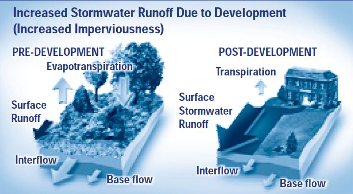
Source: CWP, 1999
Development increases the amount of impervious cover and disrupts the natural water balance. The amount of stormwater runoff increases dramatically (see arrows).
Why manage stormwater?
The ultimate goal of stormwater management is to maintain the health of streams, lakes and aquatic life as well as provide opportunities for human uses of water by mitigating the effects of urban development. To achieve this goal stormwater management strives to maintain the natural hydrologic cycle, prevent an increased risk of flooding, prevent undesirable stream erosion, and protect water quality.
Maintain the natural hydrologic cycle
A decrease in infiltration reduces soil moisture replenishment and groundwater recharge. Soil moisture is required to sustain vegetation. Loss of groundwater recharge can reduce stream baseflow, the flow that continues between storms and sustains aquatic life. It can also reduce the quantity of groundwater available for domestic and agricultural water supplies.
Prevent an increased risk of flooding
Summer floods, resulting from high intensity thunderstorms, are more common in urban areas because of the increased runoff of precipitation and the presence of systems that carry this runoff to streams quickly. Flooding can lead to loss of life and property damage.
Prevent undesirable stream erosion
Erosion is a normal part of stream behaviour. Stormwater is managed to prevent excessive erosion that may prohibit a stream from fulfilling its normal function of conveying water and sediment. As a consequence of urbanization, there is an increase in the volume and rate at which sediment and water are delivered to streams. This causes an increase in the erosive forces on stream banks and beds that dislodge and transport particles and, over time, damage the natural form of streams (Figure 3). Streams change shape and enlarge, the size distribution of stream bed sediments changes, and meander patterns may also be affected. Degradation of stream habitat leads to a decline in plant and animal diversity.
Figure 3: effects of development on streams (at 5% and 30% impervious cover in watershed)
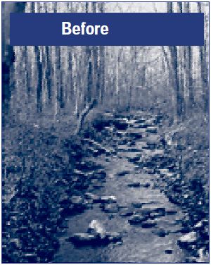
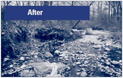
Sources: Top photo, CWP, 1999. Bottom photo, CWP, 1999
In watersheds with less than 5% impervious cover, streams are typically stable and pristine, maintaining good pool and riffle structure, a large, wetted perimeter during low flow, and a good riparian canopy coverage.
| Stormwater Contaminant | Source |
|---|---|
| Suspended Solids/Sediment | Construction sites, roads, winter sanding |
| Nutrients (nitrogen and phosphorous) | Fertilizers, pet wastes, yard wastes |
| Metals | Cars |
| Oil and Grease | Cars, leaks, spills |
| Bacteria | Pet wastes |
| Pesticides and Herbicides | Yard and garden care |
| Heat (increased water temperature) | Exposure to air in warm season |
Protect water quality
Contaminants, such as oil, grease, metals and pesticides, tend to build up on surfaces in urbanized areas (Box 1). These contaminants come from sources such as pavement deterioration, tire and brake pad wear, vehicle emissions and spills (Figure 4). They may also come from yard and garden care, and pet feces. Stormwater runoff picks up these contaminants and can transfer them to streams or groundwater.
Figure 4: key pollutant deposition pathways on the street surface
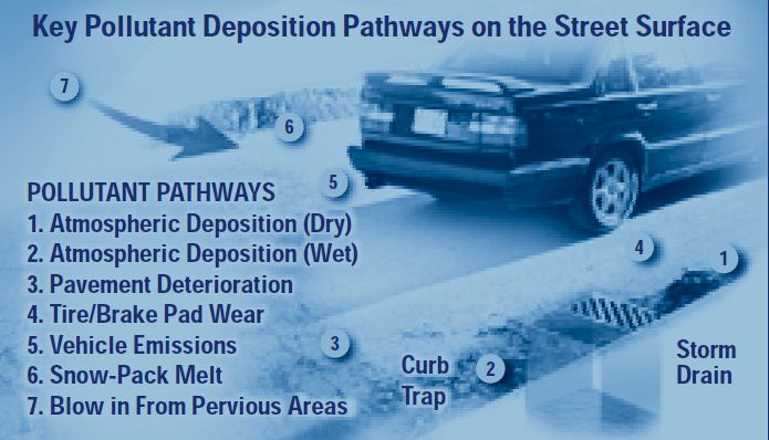
Pollutants from the street surface can be picked up by stormwater and end up in a lake or stream.
Degradation of water quality can result in a decline in plant and animal diversity. It may also affect drinking water supplies and recreational uses of water such as swimming.
How can so many goals be achieved?
Integrated planning
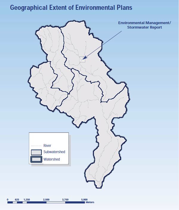
Integrated planning should integrate land use planning and environmental planning, in order to balance environmental, social, and economic needs. Environmental plans include watershed plans which address environmental issues at a watershed level and subwatershed plans that cover smaller areas in more detail. In areas where development is contemplated environmental management plans and stormwater management plans are done which cover even smaller areas in even greater detail (Figure 5). These plans provide important information to key decision points in the land use planning process. The important natural features and functions of a watershed or subwatershed (Box 2), and their linkages or interrelationships must be identified. This involves scientific study, but stakeholders also help to define "importance" and set goals for their watershed.
Box 2: definitions of watershed and subwatershed
- Watershed
- A watershed is the land drained by a river and its tributaries. It is separated from adjacent watersheds by a land ridge or divide.
- Subwatershed
- A subwatershed is the land that drains to a tributary of a river.
Figure 5: geographical extent of environmental plans
Source: MOE et al., 2003 (adapted)
Graphical representation of environmental plans at different levels (watershed, subwatershed, and local/site-specific)
Several strategies that meet the defined goals are developed to manage human activities within a watershed. These will involve various combinations of management options, including stormwater management practices. Integrated planning for stormwater management helps to ensure that preventative approaches are incorporated in the management strategies. Preventative approaches include protection of natural areas and site design of communities to reduce stormwater runoff generation. Integrated planning also helps to identify constraints and opportunities for the use of particular stormwater management practices.
A preferred strategy is selected from the management options and is evaluated against criteria such as public acceptance, cost, and technical feasibility.
Prevention
One of the key ways to achieve the goals of stormwater management is through prevention. Pollution prevention measures prevent the contamination of stormwater (Box 3). Municipalities, businesses and individuals can put pollution prevention measures into practice. The Stormwater Pollution Prevention Handbook, 2001 provides fact sheets on a number of pollution prevention measures such as those listed in Box 3.
| Measure | Benefit |
|---|---|
| Xeriscaping (use of drought tolerant plants) and natural lawn care. | Water conservation and reduction of pesticides and fertilizers entering stormwater. |
| Safe storage, use and disposal of harmful products. Use of safer alternatives. | Reduction of toxic contaminants entering stormwater. |
| Reduced vehicle use. | Improved air quality, but also reduction of oil and grease, metals and other contaminants entering stormwater. |
| Proper disposal of pet feces and litter. | Reduction in oxygen demanding substances, nutrients and bacteria entering stormwater. Improved aesthetics. |
| Avoid excessive use of road salt and de-icers. | Reduction of contaminants entering stormwater. Particularly important because treating water to remove road salt is difficult. |
| Effective parking lot and street cleaning. | Reduction in sediment and many associated contaminants entering stormwater. |
Reducing "car habitat" (Box 4) and protecting natural habitat go hand in hand to prevent the generation of stormwater runoff in the first place. Changes to municipal development standards, such as reducing front and side yard setbacks, may be required to implement some of the techniques for reducing car habitat.
Everyone has a role to play in prevention. It may be an active role, such as using public transit or safer products. It may mean accepting alternatives to large lot communities and traditional lawns.
Box 4: reducing car habitat
- Reduce residential street width
- Reduce residential street length (use alternative community layouts)
- Reduce impervious area created by cul-de-sacs
- Reduce length of driveways
- Avoid excessive parking lot size
- Use effective parking lot design
Protecting natural areas
Natural areas perform a multitude of functions: maintenance of groundwater recharge and baseflow, prevention of stream erosion and flooding, and protection of water quality. In other words, they perform the same functions as stormwater management systems!
Vegetated stream buffers reduce the effects of development on a stream by filtering pollutants, providing shade and bank stability, and reducing the velocity of stormwater runoff. Wetlands store and slow flood water and enhance water quality. Forested areas reduce and delay stormwater runoff by intercepting and storing precipitation.
"Treatment Train"
Unfortunately, the effects of urbanization cannot be mitigated through prevention alone. A stormwater management "treatment train" is a series of practices that meets stormwater management objectives for a given area (Box 5).
Box 5: some terminology used by stormwater practitioners
- A stormwater management control, measure or practice, such as a grassed swale or wet pond
- an individual element of a system. It may be a lot-level, conveyance, or end-of-pipe control. A practice may perform one or more functions, such as pretreatment or treatment, infiltration, or storage for flood and erosion control. However, a single practice can rarely perform all of the necessary functions of a stormwater management system.
- A stormwater management system or treatment train
- a series of practices that meets stormwater management objectives for an area. For example, rear yard soakaway pits (a lot-level control), grassed swales (a conveyance control), and a wet pond (an end-of-pipe control) may comprise a treatment train. For a commercial area, the treatment train might consist of oil/grit separators (pretreatment), filters (water quality control) and a wet pond (erosion, flooding, and quality control).
- A stormwater management strategy
- a combination of preventative measures and stormwater management systems that collectively minimize the effects of stormwater in a subwatershed. It may be a part of a larger management strategy that includes other techniques, such as channel restoration, to achieve the overall environmental goals set for the subwatershed.
The "treatment train" approach combining lot-level, conveyance and end-of-pipe controls, is required to meet the multiple objectives.
Lot-level controls are those that are applied on individual lots (e.g. on residential properties) or for areas less than two hectares. The stormwater runs off the lot into a ditch or a sewer which is part of the conveyance system. The conveyance system drains or conveys the runoff from the lots to an end-of-pipe facility. End-of-pipe control facilities are those that receive stormwater runoff from a conveyance system and discharge the treated water to receiving waters (usually a lake or stream).
More about the treatment train
Lot-level and conveyance controls
Most lot-level and conveyance controls may be classified either as storage controls or infiltration controls. Storage controls are designed to temporarily store stormwater runoff and release it at a controlled rate (Box 6). Although the volume of runoff does not decrease, the risk of flooding is reduced because all the stormwater runoff does not arrive at the stream at the same time.
Box 6: storage controls
- Rooftop storage
- Parking lot storage
- Superpipe (oversized storm sewer) storage
- Rear yard storage
The primary function of infiltration controls is to promote infiltration into the ground in order to maintain the natural hydrologic cycle (Box 7). This can be best accomplished by lot-level infiltration controls because these can best recreate the pre-development conditions.
Box 7: infiltration controls
- Reduced lot grading
- Rear yard surface ponding
- Rear yard soakaway pits
- Infiltration trenches
- Pervious pipe systems
- Grassed swales
- Vegetated filter strips
Infiltration techniques can achieve water quality enhancement. However, these measures are ideally suited for the infiltration of relatively clean stormwater including rooftop and foundation drainage. Stormwater containing lots of sediment can plug infiltration controls unless the sediment is first removed (pretreatment). Practices that may be used for pretreatment are listed in Box 8.
Box 8: pretreatment controls
- Sand filters
- Vegetated filter strips
- Grassed swales
- Oil/grit separators
Infiltration of stormwater containing contaminants, such as road salt, can have the undesirable effect of impairing groundwater quality. Preventative measures to minimize the amount of road salt entering stormwater are important because stormwater pretreatment and treatment practices do not remove road salt.
End-of-pipe controls
End-of-pipe stormwater management practices must control the effects of urbanization which remain after preventative techniques and lot-level and conveyance measures have been applied. End-of-pipe facilities are usually required for flood and erosion control and water quality improvement, although lot-level and conveyance controls can reduce the size of the end-of-pipe facilities required (Box 9).
Box 9: end-of-pipe controls
- Wet ponds
- Wetlands
- Dry ponds
- Filters
- Infiltration basins
- Oil/grit separators
Stormwater management design criteria
Design criteria may be thought of as the link between the goals set through environmental planning and the design of a stormwater management system. They are numeric expressions of the quality and quantity of water required to maintain the health and diversity of aquatic life and opportunities for human uses.
To maintain the hydrologic cycle
A common approach to maintaining the hydrologic cycle is to specify that post-development infiltration must be equal to the pre-development infiltration. The quantity of water that must be infiltrated via stormwater controls, to compensate for vegetation changes and increased imperviousness, can be estimated using a range of techniques from equations to computer models.
The distribution of infiltration is also an important consideration. Even if the quantity of infiltration is kept the same after development, too much infiltration in a small area can change groundwater flow patterns including the locations of groundwater discharge. Wetlands and streams and the associated plants and animals depend on groundwater discharges. Computer models can address this spatial aspect but require a lot of good data (such as soil types and water levels) to be effective.
To prevent an increased risk of flooding
It is usually specified that maximum peak flows (or volumes per unit time) must not exceed predevelopment values for large storms. Large storms include the 2, 5, 10, 25, and 100-year storms (Box 10).
Peak flows are controlled by detaining runoff so that it does not all reach the stream within a relatively short time period during or soon after a storm. But, care must be taken so that detained runoff from different parts of the watershed does not all arrive at the same location at the same time. Holding runoff longer in the upper parts of a watershed will ensure that this does not happen.
Box 10: storm frequency analysis
The 10-year storm refers to the storm that statistically occurs once every 10 years. The historical rainfall record is used for the statistical analysis. Large storms are extreme events. More extreme events occur less frequently. More rainfall is associated with the 25-year storm than with the 10-year storm (for a given storm duration).
To prevent undesirable stream erosion
The erosive forces that tend to dislodge and transport stream channel materials are related to the volume and rate at which sediment and water are delivered to the stream. Stream channels change in response to the increase in erosive forces brought about by urbanization. The severity of the change is related to the magnitude of the increase in erosive forces and the stream’s ability to resist. The channel materials, the type and distribution of riverbank vegetation, and the existence of prior disturbances affecting a stream’s stability are factors that contribute to its ability to resist changes.
Under pre-development conditions, stream channel form is governed by flows that fill the channel these result from the two-year storm. After development, flows reaching between the halfway mark and top of the channel become more common and are responsible for the increase in erosion. Therefore, controlling the runoff from the storms causing these flows protects stream channels and the habitat they provide.
To protect water quality
The criterion for quality is usually expressed in terms of the percentage of suspended solids/sediment which must be removed from stormwater to protect aquatic life. For example, 80% or better removal (also referred to as enhanced protection) may be required for sensitive aquatic habitats.
Suspended solids, including both organic and inorganic matter, increase turbidity (or decrease the clarity of water). This interferes with the photosynthetic activity of plants. It can also interfere with feeding for those fish that rely upon sight. Solids in suspension can clog the gills of fish. Sediment that settles may cover spawning areas and smother communities of organisms that live on the bottom of streams. The decay of organic matter exerts an oxygen demand that may severely depress the levels of dissolved oxygen in receiving waters. Other stormwater contaminants (such as metals, pesticides and some forms of nutrients) tend to be attracted to solids and are removed from stormwater with the solids.
Additional criteria may be needed for special concerns. For example, if recreational activities, such as swimming, occur downstream of a stormwater facility, there may be a criterion related to bacteria which the design will have to address. If the receiving water is a coldwater fishery, temperature may be a concern. This issue is described further in the section entitled Too Hot.
More about selected stormwater management practices
Stormwater management practices have diverse forms: at surface or below ground; permanently or only temporarily wet; with or without vegetation; promotes infiltration or detains stormwater. A variety of stormwater management practices are described below.
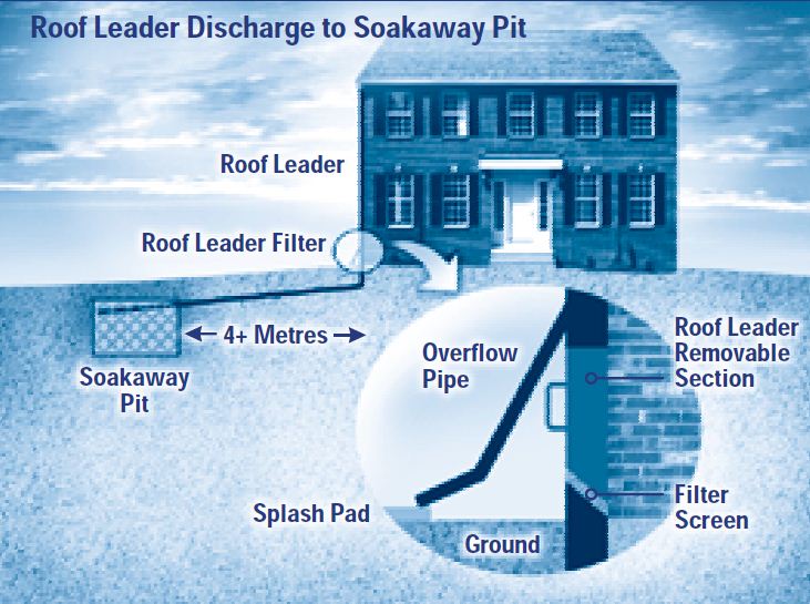
Soakaway pits/infiltration trenches
Soakaway pits and infiltration trenches are stone-filled (golf ball size) excavations where stormwater runoff collects and then infiltrates into the ground. Infiltration trenches receive stormwater from several lots in contrast to soakaway pits which are used for individual lots (Figure 6). A filter layer at the base of the trench provides water quality enhancement of the stormwater as it moves into the surrounding soils. These practices can only be used where soils allow the trench to empty within a reasonably short time.
Figure 6: roof leader discharge to soakaway pit
Source: MOE, 2003
Grassed swales
Grassed swales are typically shallow depressions several metres wide that convey stormwater. The vegetation slows and filters stormwater. Dams can be incorporated at intervals along swales to promote infiltration and settling of contaminants. Ditches and culverts (swales separated by culverts at driveways) may be used in residential areas as an effective alternative to curbs and gutters.
Pervious pipe systems
In a pervious pipe system, a perforated pipe is located in a bed of golf ball sized stone. The perforations allow water to flow out of the pipe as it is conveyed downstream. The water is stored in the stone medium until it can infiltrate into the surrounding soils. These systems can only be applied where the soils allow the storage medium to empty within a reasonably short time.
Dry ponds
A dry pond is a detention basin designed to temporarily store collected stormwater runoff and release it at a controlled rate through an outlet. Dry ponds may have a deep pool of water in the sediment forebay to reduce scour and resuspension of sediment, but do not have a permanent pool of water in the main basin. This means that there is no opportunity for settling of contaminants between storm events and dilution of stormwater contaminants during storms. Therefore, although dry ponds can be effective for erosion and flood control, they do not perform as well as wet ponds for water quality control.
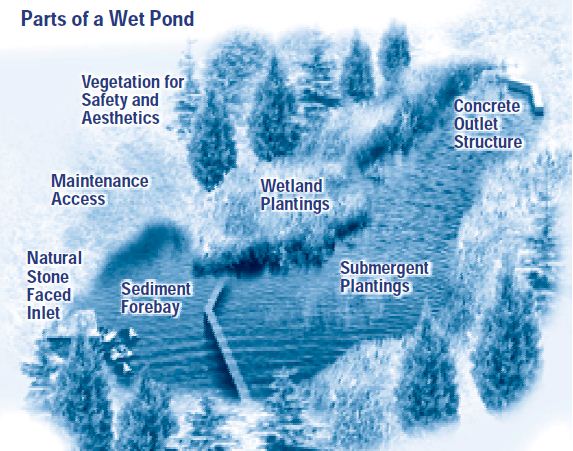
Wet ponds
A wet pond is a detention basin designed to temporarily store collected stormwater runoff and release it at a controlled rate. It is different from a dry pond in that it maintains a permanent pool of water between storm events. Wet ponds (Figure 7) are the most common endof-pipe stormwater facility used in Ontario. A single wet pond can provide water quality, erosion, and flooding control. Box 11 describes how a wet pond works.
Figure 7: parts of a wet pond
Source: MOE, 2003
Box 11: how does a wet pond work?
An inlet allows stormwater supplied by the conveyance system to go into the pond. The water first flows into a sediment forebay, a small basin located before the main pond. The stormwater rapidly slows down and drops much of its sediment load. The forebay design prevents erosion and re-suspension of the settled sediment and allows for easy removal of accumulated material.
From the forebay, water flows into the main pond. Wet ponds have a permanent pool of water. Stormwater flowing into a wet pond is diluted by the permanent pool. Between storms, sediment trapped in the permanent pool has time to settle. In addition to the permanent pool of water, wet ponds have an active storage volume which is used during and after a storm, but which subsequently drains. This active storage is multi-functional, but is needed particularly to store the runoff from larger storms which otherwise could contribute to erosion and flooding of the receiving stream.
Outlets are designed to detain water in the pond long enough to allow sediment removal and to alleviate erosion and flooding concerns. Multiple outlets are needed when water quality, erosion, and flooding control storage volumes are provided. The outlets may be at different elevations and be designed to allow the stored water to empty at different rates.
The effectiveness of a pond is improved by shaping it to lengthen the path of water between the inlet and outlet. Vegetation enhances water quality. The pond is graded and landscaped to stabilize banks and slopes, increase public safety, and provide aesthetic and recreational benefits.
Constructed wetlands
In contrast to wet ponds, constructed wetlands are dominated by shallow zones (less than 0.5 m). More vegetation can be incorporated into wetlands with the associated potential for water quality enhancement. However, because of their shallow depth, constructed wetlands are more land intensive than wet ponds and their application to flood control is limited.
Infiltration basins
Infiltration basins may be needed in some situations to provide adequate groundwater recharge. However, water collected from a large area must infiltrate in a relatively small area. This does not replicate natural conditions as well as lot-level and conveyance infiltration controls. Infiltration basins can only be used where there are soils through which water can rapidly flow. They are ineffective for flood control because with larger water depths soil tends to be more compacted, allowing less infiltration. Pretreatment of stormwater is required to prevent groundwater contamination and clogging of soils.
Filters
Filters are stormwater management practices used for water quality control by filtering runoff through a bed of sand or other media. There are many types of filters. They may be at the surface or underground, and the filter media may be sand and/or organic material such as peat. Filters can be incorporated into most parking lot areas and commercial sites.
Vegetated filter strips
Vegetated filter strips (grass or forested) usually consist of a small dam and planted vegetation. The dam is constructed perpendicular to the direction of flow and ensures that the flow is spread evenly over the vegetation which filters out pollutants and promotes stormwater infiltration. Vegetated filter strips can be used as an infiltration control, or a pretreatment control, and are best used adjacent to a buffer strip, watercourse, or drainage swale.
Oil/Grit separators (OGS)
Oil/grit separators (OGS) are used to trap and retain oil and sediment in detention chambers usually located below ground. Sizing and design of OGS depends on their function. OGS are used for spill control, as pretreatment devices, and for water quality control. OGS have been used for industrial and commercial sites, and large parking areas or transit facilities where there is sediment build-up and a higher risk of spills.
Stormwater management practice design
Where to locate?
Physical factors may suggest the use of particular stormwater management practices and preclude the use of others, or they may point to special design requirements. Reduced lot grading is impractical for steeply sloping sites. Infiltration controls require soils coarser than loam and bedrock and water table depths greater than 1 metre, in order for them to empty within a reasonable time. Wet ponds and wetlands require drainage areas of at least 5 hectares or a high groundwater table to prevent permanent pools from becoming stagnant or drying up.
Some separation from constructed objects may be required. Soakaway pits and ponding areas should not be located near buildings to avoid foundation drainage problems. Infiltration trenches should be set back from sewage system leaching beds to avoid interference between these subsurface systems.
How big?
The sizing of a stormwater management practice depends upon the functions it is to perform and follows from the design criteria. To address flooding concerns, a stormwater management practice must have the capacity to store large amounts of runoff generated infrequently by large storms or snowmelt events.
To address water quality concerns, only the runoff from smaller, more frequent storms needs to be stored. However, the stormwater must be held long enough for most of the sediment to settle out, so allowance is made in storage volumes in case a second storm follows on the heels of the first.
There is often a limit to the depth of water in stormwater management practices. The depth of water in rooftop storage may be limited to prevent exceedance of maximum loads on the structure. The depth of water in soakaway pits and trenches may be limited to ensure that the storage media can drain within a relatively short time. To maximize filtration in grassed swales and vegetated filter strips, flow depths should be minimized. The water depths in ponds and wetlands are limited for a variety of reasons including the tolerance of vegetation.
What else?
Knowing the required volume and depth restrictions, the configuration (depth, length, width, slopes) of the stormwater management practice can be optimized. Then, the unique features of each stormwater management practice must be designed. As an example, Box 12 lists the design details that might be specified for an infiltration trench.
| Size and type of storage media | 50 mm diameter clear stone |
|---|---|
| Depth and type of filter media | 0.3 m sand with effective diameter (d10) = 0.25 mm and coefficient of uniformity (Cu) < 3.5 |
| Geotextile | Non-woven filter fabric at interface of trench and native material |
| Distribution pipes | 100 mm diameter perforated pipe, 1 m spacing, 0.75 m below top of storage layer |
| Soil cover | 1.0 m |
| Planting strategy | Grass/herb mixture. No deep rooted plants |
| Monitoring | Observation well |
More design challenges
Too hot
Urbanization causes stormwater temperature to increase because stormwater drains over impervious areas like pavements and roads that get heated up during the summer. Stormwater management practices may exacerbate this problem. This is a major concern for coldwater fisheries. Thermal impacts may be reduced by minimizing the surface area of water exposed to the air, planting vegetation that shades open water, and releasing water in the early morning when it is coolest.
Too cold
Ontario’s cold season presents some design challenges. Modifications to the slopes and diameters of pipes and to the locations of inlets and outlets may be required to prevent them from becoming blocked with ice. The permanent pool volume of wet ponds may need to be increased to compensate for the volume taken up when ice forms.
Too much
Stormwater management practices designed primarily to improve water quality will not have the capacity to accommodate the larger flows that may be delivered by the conveyance system. Flow splitters (picture a concrete box with a dividing wall that does not extend all the way to the top) direct acceptable quantities of stormwater to the facility but bypass excess flows from larger events to another stormwater management practice or to the receiving water. This prevents problems such as re-suspension of sediment or damage to the facility.
Don't forget the maintenance
Lack of maintenance is one of the main reasons for poor system performance. During the first two years of operation, inspections after significant storms will ensure the system is functioning properly. After this, annual system inspections are usually done to identify maintenance needs.
Blockages may need to be cleared from inlets or outlets. Unhealthy vegetation may need to be tended or replaced. The design of stormwater management practices for water quality improvement is based primarily on settling of sediment. Therefore, at some point, accumulated material will need to be removed.
Maintenance is an important consideration during design. Maintenance and operation costs need to be considered in addition to capital costs when selecting a preferred management strategy.
Need more technical information?
The Stormwater Management Planning and Design Manual (2003) is available on the Ministry of Environment’s website.
Hard copies can be purchased from Publications Ontario at:
1-800-668-9938/416-326-5300.
The Stormwater Pollution Prevention Handbook is available on the Ministry of Environment’s website.
Hard copies can be purchased from the MOE's Public Information Centre at:
1-800-565-4923/416-325-4000.