Upper Madawaska River Provincial Park Management Statement
This document provides policy direction for the protection, development and management of Upper Madawaska River Provincial Park and its resources.
November 13, 2001
Background information
- Name: Upper Madawaska River Provincial Park
- Proposed class: waterway
- M.N.R. district: Bancroft
- M.N.R. region: central
- Total area (ha): 1,085
- Site Region: [Unavailable]
- Site district: [Unavailable]
- Date in regulation: [Unavailable]
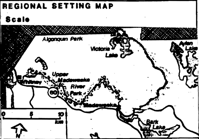
Regional setting map
Targets
Life science representation
- Site type/Landscape unit: Situated in the crown of dome shaped Algonquin Highland sporadic sand bars within rocky section with a sand plain to the East.
- Species/communities: Mixed hardwood speckled alder, winterberry, holly and shrubs with white birth being primary species.
Earth science representation
- Geological theme: Canadian Shield Ontario gneiss Underlain by late & middle Precambrian rocks.
Cultural resource representation
- Theme: [Unavailable]
- Theme Segment: [Unavailable]
Recreation opportunities
- Day Use: [Unavailable]
- Car Camping: [Unavailable]
- Wilderness/Back country: 1,000
| Level/Type | Earth science | Life science | Cultural | Recreation | Other |
|---|---|---|---|---|---|
| Reconnaissance completion date | N/A | N/A | N/A | N/A | N/A |
| Detailed completion date | N/A | N/A | N/A | N/A | N/A |
| Required? | N/A | N/A | N/A | N/A | N/A |
Regional Director’s approval statement
This revised Interim Management Statement will provide interim direction for the management of the above Provincial Park until a comprehensive Park Management Plan is prepared.
This statement will provide the basis for subsequent preparation of the Park Management Plan.
I am pleased to approve this Interim Management Statement.
J. Winters
Park Superintendent
Algonquin Park District
Ontario Parks
April 1997
Foreword
An Interim Management Statement (IMS) is intended to guide the management of a park until such a time as a Park Management Plan is prepared. As a minimum standard, the IMS will identify park values to be protected, the resource management prescriptions necessary to protect those values, and restrictions on existing or potential use.
An IMS is not intended to replace a Park Management Plan. It should keep future options open, maintaining flexibility until a management plan is approved.
Interim Management Statements should as a general rule, adopt a cautious approach, recognizing that the planning exercise is based on limited information. Major decisions, particularly those which could be considered permanent or irreversible, should be left to park management planning - a process which includes public consultation.
Upper Madaskawa River Waterway Provincial Park Interim Management Statement
I. Land tenure
The park is made up of crown land in the Townships of Airy and Murchison. Where private land is located adjacent to the park the park boundaries follow along the river until it comes to the end of the private land then it goes back to being 200m from the high water mark.
Guideline:
There will be no further granting of LUPs within the park.
The existing activity will continue however in the long term the four hunt camps, one cottage, tourist camp and one trapping cabin will be phased out.
II. Existing/new development
Presently no park development exists. There are however four hunt camps (Land Use Permits, LUPs), one cottage, a commercial tourist camp, and one trapping cabin within the park boundaries. Other existing developments in the park include a rehabilitation gravel pit, the CNR right-of-way and a hydro corridor and access bridge.
Guideline:
Hunt camps and trap lines will be phased out. Existing ones will be allowed to continue until retirement.
Two minor access points should be constructed or renovated in order to service the park. They will be located at Rapid Lake, and at the bridge on Major Lake Road (Shall Lake Road). Entrance roads will have to be upgraded, parking lots constructed to accommodate five vehicles, designated canoe and Kayak launching area and position park road sign and information kiosk.
The access point at Rapid Lake should be looked at further to assess its feasibility as an access point.
The District will maintain the existing canoe routes and portages. It will also continue to monitor the use of campsites and evaluate potential areas for additional sites.
III. Recreation activities
The Upper Madaskawa River is classified as a Waterway Provincial Park. Existing recreational uses of the Upper Madawaska River include canoeing, kayaking, and fishing. The old CN railway line which extends along large portions of the park is used extensively for hunting, hiking, camping, dirt bikes, all-terrain vehicles, snowmobiling and cross-country skiing.
Guideline:
Management will be focused on providing backcountry travel along the river. No car camping will be developed. New campsites may be developed along the river in the mid-point area of most trips.
All of the above activities will be allowed to continue while this Interim Management Statement is in place. If there are any conflicts in the future, (i.e., all-terrain vehicles vs. hiking) or evidence of environmental degradation, necessary restrictions will be implemented to ensure public safety and the protection of park values.
Decisions on recreation activities that will be permitted in the Park will be made during n1anagement planning with public involvement.
IV. Resource management
Wildlife:
Guideline:
Animal populations may be controlled when it is essential to protect human health and safety or the health of other species inside the park. Control measures will be carried out by the Ministry of Natural Resources, or under its supervision.
An Interim Nature Reserve zone should be added to the park to give some added protection to areas within the park that are inhabited by rare Wood Turtles until a formal management plan is put in place.
Fisheries:
Guideline:
Sport fishing will be permitted in the park. Special seasons, size, and catch limits may be established. Native fish species may be stocked.
Vegetation:
Guideline:
Vegetation may be managed to complement aesthetic values, wildlife habitat, and interpretation efforts. Commercial forest operations will not be permitted in the park. Non-native plant species will not be introduced and fertilizers can only be used in Access zones.
Hunting/Trapping:
Guideline:
Hunting is now permitted only in the Natural Environment zone. The length of hunting season will be regulated according to the Provincial Parks Act. A decision on hunting will be made during management planning with public involvement.
Commercial trapping will be phased out and no new trap lines will be established within the park.
Water Control:
Guideline:
Water control structures will not be permitted in the park. Water control practices in the Natural Environment zone will be limited to modest channel improvements made to improve the recreational navigation which will not substantially alter the flow or morphology of the watercourse.
Minerals:
Guideline:
No commercial exploration or extraction will be permitted within the park. Where aggregate is required for development, maintenance or improvement of park facilities, it will be imported from external sources. The pit currently within the park boundaries will be rehabilitated according to the Pits and Quarries Control Act (Regulation 784).
V. Fire
Guideline:
All forest fires will be suppressed. Techniques used will have a minimal effect on the environment.
Fire protection is provided by the Haliburton Fire Management Headquarters sector 1 response.
VI. Client services
There are no client services provided in the park at this time. Information about the park and its water routes can be found at the East Gate of Algonquin Park.
Guideline:
Canoe route information will continue to be made available to the public. Additional client services will not be provided until a Management Plan has been completed, except as required by legislation or by M.N.R. policy.
VII. Research
Guideline:
Research by qualified individuals, which contributes to the knowledge of our natural and cultural history and to the environmental and recreational management of our waterways, will be encouraged in the park. Consideration will be granted for ecological surveys to map and describe the flora and fauna of the park for management purposes.
All research programs will require the approval of the Ministry of Natural Resources and must meet all requirements.
VIII. Transportation and utility corridors
Guideline:
Road and utility line crossings may be necessary in order to maintain essential public services and commercial forest operations outside Upper Madawaska River Park’s boundaries. The number of existing and future crossings should be minimized where possible. Crossings will be managed to minimize their interference with recreational and aesthetic values.
References/sources
O.M.N.R. 1989. Upper Madawaska River provincial Park: Preliminary Management Plan (draft).
Ontario Ministry of Natural Resources. Bancroft District Land Use Guidelines, Publication Number 5876, Bancroft, 1983.
Ontario Ministry of Natural Resources. Ontario Provincial Parks Management Planning Reference, Parks and Recreational Areas Branch, Queen’s Printer for Ontario, Queen’s Park, 1988.
Ontario Ministry of Natural Resources. Ontario Provincial Parks Planning and Management Policies, Parks and Recreational Areas Branch, Queen’s Park, 1978.
Ontario Ministry of Natural Resources. Provincial Parks Policy PM. 1.00, Parks and Recreation Areas Branch, Queen’s Park, 1989.
Ontario Ministry of Natural Resources. Upper Madawaska River/Opeonogo River Provincial Parks Management Plans. Terms of Reference. Unpublished Report, Parks and Recreation Areas Branch, Algonquin Region, Huntsville, 1989.
Figure 1: Regional context map for Upper Madawaska River Provincial Park
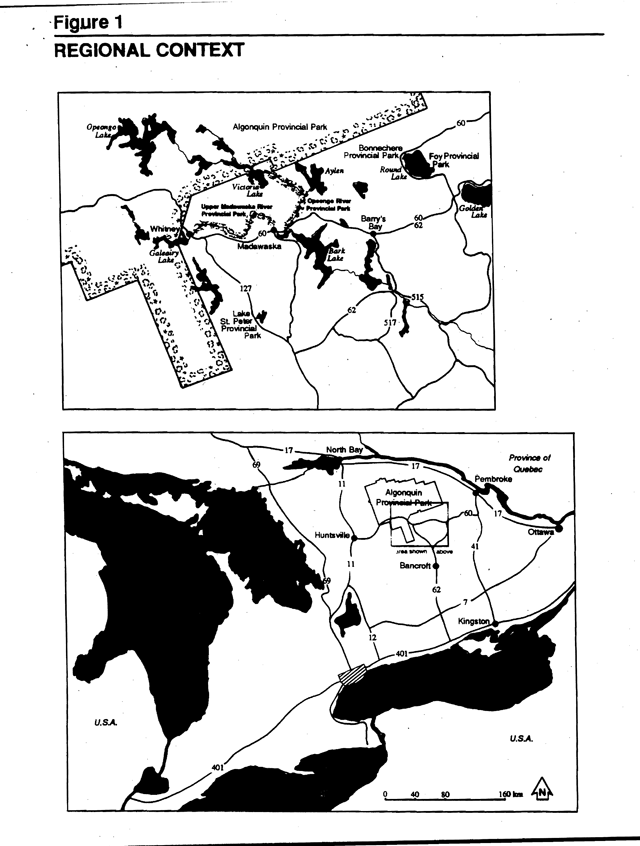
Figure 2: Park boundary and tenure map for Upper Madawaska River Provincial Park
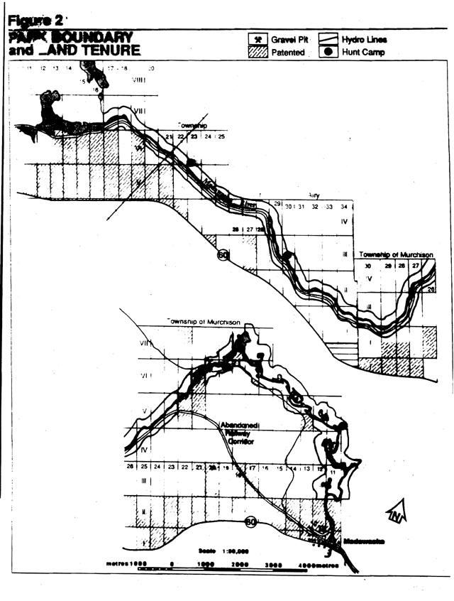
Figure 3: Map of significant features for Upper Madawaska River Provincial Park
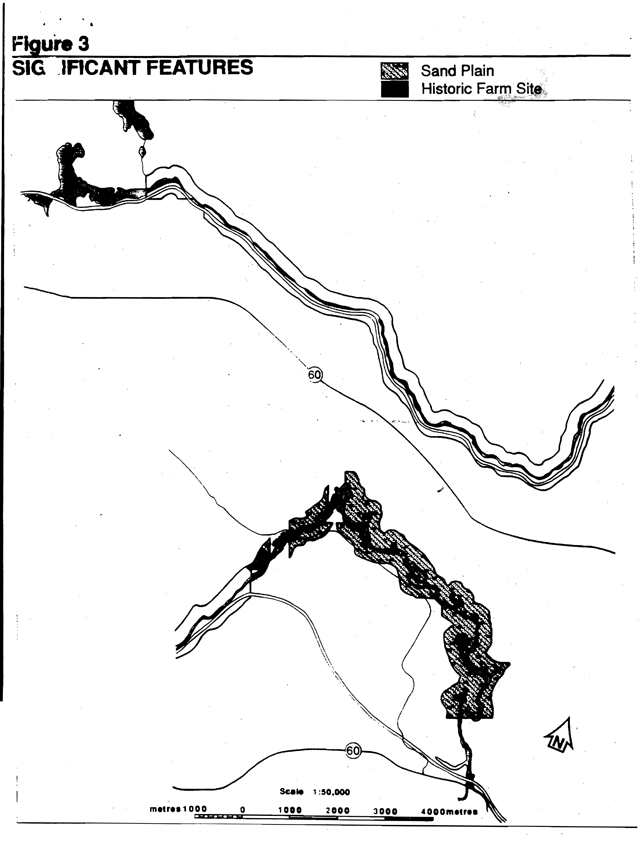
Figure 4: Zoning map for Upper Madawaska River Provincial Park
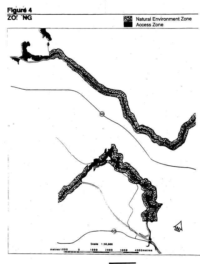
Figure 5: Future development map for Upper Madawaska River Provincial Park
