Upper Shebeshekong Wetland Conservation Reserve Management Statement
This document provides policy direction for the protection, development and management of the Upper Shebeshekong Wetland Conservation Reserve and its resources.
(C115)
Statement of Conservation Interest
March 2005
Ministry of Natural Resources
Parry Sound District
Prepared with the assistance of:
Meteek & Company
Huntsville, Ontario
Approval statement
We are pleased to approve this Statement of Conservation Interest for Upper Shebeshekong Wetland Conservation Reserve (C115).
Upper Shebeshekong Wetland Conservation Reserve is a 5,304 hectare area of Crown land that extends to the shoreline of Georgian Bay. The northern portion of the site is located in the geographic township of Shawanaga; most of that area is within the Municipality of the Township of The Archipelago, although the extreme eastern portions are unincorporated. The southern portion of the site is located within the Township of Carling. A portion of the northern boundary of this site is adjacent to Shawanaga First Nation territory. There is an isolated parcel of three lots (Lot 15, Concession 1 in the geographic township of Shawanaga, and Lots 20 and 21, Concession 10 in Carling Township) totaling 123 hectares, approximately one kilometre east of the main conservation reserve.
The name of this protected area was changed from Shawanaga-Shebeshekong Conservation Reserve (as referred to in the Land Use Strategy), in order to avoid confusion with two other conservation reserves in this area which include the name "Shawanaga" in their site names. It was decided that the name of Upper Shebeshekong Wetland Conservation Reserve is more representative of the site, since most of the area is within the 'Shebeshekong' River watershed, and the name more accurately reflects one of the key values: the presence of a large complex of diverse wetlands.
Upper Shebeshekong Wetland Conservation Reserve protects extensive shoreline and interior habitat east of Shawanaga Inlet, contributing to an almost continuous naturally vegetated landscape along the northern portion of the Georgian Bay coast. The site protects habitat for provincially and locally significant flora, fauna and vegetation community types, and species requiring large undisturbed tracts of landscape to maintain viable populations. The site protects portions of four different biophysical units, large representative examples of jack pine treed rock barrens, fens, beaver-controlled meadow marsh and aquatic communities and dry pine – oak woodlands, as well as moderate-sized examples of Georgian Bay coastal meadow marshes, coniferous swamps and richer moist deciduous forests and swamps. This site provides representation of 64 landform – vegetation community types.
The area is used for a variety of traditional recreational uses including hunting and fishing. It is also used for a variety of purposes by local First Nations, including hunting, fishing and gathering.
The Ontario’s Living Legacy Land Use Strategy commits that Upper Shebeshekong Wetland Conservation Reserve provides possible co-management opportunities with local First Nations. Discussions with local First Nations are currently underway to explore these co-management opportunities in this conservation reserve.
Upper Shebeshekong Wetland Conservation Reserve is one of 378 new protected areas approved through Ontario’s Living Legacy Land Use Strategy, aimed, in part, at completing Ontario’s system of parks and protected areas. It is part of the Great Lakes Heritage Coast, a signature site identified through Ontario’s Living Legacy Land Use Strategy. The Great Lakes Heritage Coast is designed to protect the coastal environment and provide for recreational and tourism opportunities associated with the natural environment.
This conservation reserve is within the Georgian Bay Littoral Biosphere Reserve, which was recently designated by the United Nations Educational, Scientific and Cultural Organization. This designation "represents a common vision of sustainable development and environmental and cultural conservation" by a wide range of stakeholders of the area (UNESCO, 2004).
During the "Lands for Life" planning process, the public was widely consulted and provided valuable input into what became Ontario’s Living Legacy Land Use Strategy. Comments received at that time and during consultation related to the formal Public Lands Act regulation of the boundaries of this conservation reserve were generally supportive of the protection of this area. Stakeholders who provided comment during the earlier consultation for this site were subsequently consulted regarding the draft Statement of Conservation Interest and any comments were considered in the finalization of this document.
This Statement of Conservation Interest provides guidance for the management of this conservation reserve and provides the basis for the ongoing monitoring of activities. More detailed direction is not anticipated at this time. Should more complex resource management or conservation issues arise or significant facility development be considered, then a detailed Resource Management Plan will be prepared with full public consultation.
Upper Shebeshekong Wetland Conservation Reserve is managed under the direction of the District Manager and the Parry Sound Area Supervisor of the Ministry of Natural Resources, Parry Sound District.
Approved by:
R. Griffiths
District Manager
Parry Sound District
Approved by:
Ron Running
Regional Director
Southern Region
1.0 Introduction
Ontario’s Living Legacy, the result of an extensive planning process that began in early 1997, culminated in the approval in July 1999 of a Land Use Strategy that identifies the intended strategic direction for Crown land in central and northern Ontario, including the completion of Ontario’s system of parks and protected areas. This process, which included extensive public consultation, resulted in the recommendation for regulation of 378 new protected areas, including Upper Shebeshekong Wetland Conservation Reserve (C115).
Upper Shebeshekong Wetland Conservation Reserve is a 5,304 hectare area of Crown land that extends to the shoreline of Georgian Bay. The northern portion of the site is located in the geographic township of Shawanaga; most of that area is within the Municipality of the Township of The Archipelago, although the extreme eastern portions are unincorporated. The southern portion of the site is located within the Township of Carling. A portion of the northern boundary of this site is adjacent to Shawanaga First Nation territory. There is an isolated parcel of three lots (Lot 15, Concession 1 in the geographic township of Shawanaga, and Lots 20 and 21, Concession 10 in Carling Township) totalling 123 hectares, approximately one kilometre east of the main conservation reserve.
Many of the lands adjacent to this site are privately owned; these are not part of the conservation reserve and will remain privately owned. The municipal road allowances and shore road allowances that cross through or are adjacent to this conservation reserve in the Township of Carling, in the Township of The Archipelago remain in the jurisdiction of their respective municipality, and are not a part of this site.
Upper Shebeshekong Wetland Conservation Reserve protects over 10 kilometres of rugged Georgian Bay coast along Shawanaga Inlet. The extensive undeveloped coastline along Shawanaga Inlet consists primarily of sparsely vegetated bedrock shore, but there are several sandy, shallow bays supporting species-rich Georgian Bay coastal meadow marshes. The site protects approximately 5,000 hectares of largely undisturbed gneissic rock barrens, forests, peatlands, marshes, small lakes and riverine habitats, and includes several large wetland complexes, many of them peatlands with boreal affinities, as well as a portion of the Shebeshekong River and three moderate-sized inland lakes. While formal evaluation of the wetlands has not been completed, preliminary evaluation indicates that the wetland complexes are likely provincially significant.
This conservation reserve is part of the Great Lakes Heritage Coast identified through Ontario’s Living Legacy Land Use Strategy. The Great Lakes Heritage Coast is designed to protect the coastal environment and provide for recreational and tourism opportunities associated with the natural environment.
This conservation reserve is within the Georgian Bay Littoral Biosphere Reserve, which was designated by the United Nations Educational, Scientific and Cultural Organization on October 29, 2004. This biosphere reserve covers the eastern coast of Georgian Bay, from Port Severn to the Key River, and extends from roughly the middle of Georgian Bay inland more or less to Highway 69/400. This designation "represents a common vision of sustainable development and environmental and cultural conservation" by a wide range of stakeholders of the area (UNESCO, 2004).
The area is used for a variety of traditional recreational uses including hunting and fishing. It is also used for a variety of purposes by local First Nations, including hunting, fishing and gathering.
Conservation reserves are established under the authority of the Public Lands Act, Ontario Regulation 805/94. Upper Shebeshekong Wetland Conservation Reserve was established by Ontario Regulation 237/03 on June 28, 2003.
A Statement of Conservation Interest (SCI) is prepared under the direction of Procedural Guideline A – Resource Management Planning (PL. Procedure 3.03.05). The purpose of this SCI is to identify and describe the values of Upper Shebeshekong Wetland Conservation Reserve. The SCI also outlines the activities that currently occur within the conservation reserve and provides guidelines for the management of current and future activities in the context of protecting the natural, recreational and cultural values.
Figure 1: Location Map - Upper Shebeshekong Wetland Conservation Reserve (C115)
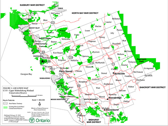
Enlarge Figure 1: Location Map - Upper Shebeshekong Wetland Conservation Reserve (C115)
Figure 2: Site Map – Upper Shebeshekong Wetland Conservation Reserve (C115)
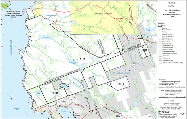
Enlarge Figure 2: Site Map – Upper Shebeshekong Wetland Conservation Reserve (C115)
1.1 Background information:
| Name | Upper Shebeshekong Wetland Conservation Reserve (C115) |
|---|---|
| Site Region/District | Georgian Bay Site Region, Site District 5E-7 |
| OMNR Administrative Region/District/Area | Southern Region/ Parry Sound District/ Parry Sound Area |
| Total Area (ha.) | 5,304 hectares |
| Regulation Date | June 28, 2003 (O. Reg. 237/03) |
| First Nations | Robinson-Huron Treaty and Williams Treaty |
| OBM map sheets | 10 17 5450 50300, 5450 50350, 5450 50400, 5500 50300, 5500 50350, 5550 50300, 5550 50350 |
| Topographic Map | Parry Sound 41H/8 Pointe au Baril 41H/9 |
| UTM co-ordinates | 17T 55152 503580 (Centroid) |
1.2 Representation:
Earth science representation:
Bedrock - Proterozoic age Grenville Province: Central Gneiss Belt, Algonquin Terrane, Britt Domain. Three of the five gneiss associations of the Britt Domain are represented, as is a younger granitic pluton.
Surficial - The site lies in the Georgian Bay physiographic region of southern Ontario. Bedrock ridges and knobs with some thin discontinuous drift over bedrock characterize the site, with small pockets of organic deposits. Quaternary erosional features, such as glacial striae and chattermarks, and P-forms (streamlined bedrock forms), may be present.
Life science representation:
Upper Shebeshekong Wetland Conservation Reserve protects over 10 kilometres of rugged Georgian Bay coast along Shawanaga Inlet and approximately 5,000 hectares of largely undisturbed gneissic rock barrens, forests, peatlands, marshes, small lakes and riverine habitats. The site includes several large wetland complexes, many of them peatlands with boreal affinities, as well as a portion of the Shebeshekong River and three moderate-sized inland lakes. The extensive undeveloped coastline along Shawanaga Inlet consists primarily of sparsely vegetated bedrock shore, but there are several sandy, shallow bays supporting species-rich Georgian Bay coastal meadow marshes.
Cultural resources representation:
No specific studies or inventories have been undertaken on the cultural heritage values within Upper Shebeshekong Wetland Conservation Reserve. Recent regional evaluation (OMNR, 2003) provides generalized broad-brush mapping which shows that this conservation reserve contains areas that have a high potential for cultural heritage sites. Private research indicates the potential for significant archaeological resources associated with the glacial Lake Nipissing shorelines in this area (Allen, 2001).
Recreational opportunities:
Upper Shebeshekong Wetland Conservation Reserve features about ten kilometres of Georgian Bay shoreline, five inland lakes, and a large complex of rock barrens, forests and wetlands, all of which combine to provide opportunities for a variety of recreational activities. Boating, canoeing and fishing in the waters of Georgian Bay contribute to shoreline use for mooring, picnicking and camping. Inland lakes are used for angling, and the area is also used for hunting. Several trails within the area are used for these activities as well as hiking, viewing and nature-related activities.
1.3 Survey work:
| Survey Level | Earth Science | Life Science | Cultural | Recreational | Other |
|---|---|---|---|---|---|
| Reconnaissance | Blackburn, 2003 | Cooper, 2002 Jalava, 2002 |
Allen, 2001 OMNR, 2003 |
Larson, 2004 | None |
| Detailed | None | None | None | None | None |
| Requirement | None | Monitor the status/ presence of significant species and associations. | Research to be encouraged. | Monitor use impacts | None |
2.0 Values to be protected
This conservation reserve is located entirely within Hills' (1959) ecological Site District 5E-7. Values include earth science, life science, cultural and recreational/aesthetic values, with an emphasis on the life sciences.
2.1 Earth science:
Bedrock:
(Earth science information, unless otherwise noted, is taken from Blackburn, 2003)
Upper Shebeshekong Wetland Conservation Reserve lies within the Britt Domain, Algonquin Terrain of the Central Gneiss Belt, in the Proterozoic Grenville Province (Easton, 1992a, b).
The Britt Domain consists of highly deformed 1.8 to 1.6 billion-year-old gneisses and migmatites of supracrustal and igneous origin that have been intruded by younger, 1.5 to 1.4 billion-year-old granitic and monzonitic plutons. The Algonquin Terrane is imbricated by later thrusting, but considered to be parautochthonous (i.e. not moved far from its root zone rocks). Although structural trends in the Britt Domain vary, the dominant trend west of Highway 69 is north-westerly. Regional scale folds plunge predominantly to the southeast. Metamorphic grade of the Britt Domain is dominantly amphibolite, overprinting earlier granulite grade metamorphism.
The Britt Domain has been divided (Culshaw et al, 1991; Easton, 1992a) into five gneiss associations, which although primarily based on rock type, also display differences in magmatism, metamorphism or mafic dike intrusion. Three of these are represented in the present conservation reserve: Nadeau Island gneiss association; Ojibway gneiss association; and Sand Bay gneiss association (Culshaw et al, unpublished-a,b). In addition, these gneiss associations have been intruded by a number of younger granitic plutons that have been folded along with the gneisses around the major fold structures. The largest of these in this southern portion of the Britt Domain is the Shawanaga granodiorite. It lies between the Nadeau and Ojibway gneiss associations: a large portion of it lies in the conservation reserve, where it is wrapped around a major antiform that passes in a north-westerly direction through the eastern part of the conservation reserve. The younger granitic rocks are designated "monocyclic" (Easton, 1992a; Culshaw et al, 1991), in that they have undergone only one folding event compared to "polycyclic" gneiss association rocks.
Classic examples of the geology of the Britt Domain are preserved along the shoreline. They have contributed and will continue to contribute to an understanding of the history of development of the Grenville Province. Exposures of Nadeau Island, Ojibway and Sand Bay gneiss association and Shawanaga pluton and Pointe au Baril suite rocks are among the best in the Ontario’s protected areas system, and are considered provincially significant.
Surficial:
This conservation reserve lies in the Georgian Bay physiographic region of Southern Ontario, characterized by very shallow soil and bare bedrock knobs and ridges (Chapman and Putnam, 1984). Upper Shebeshekong Wetland Conservation Reserve is characterized by bedrock ridges and knobs with some thin discontinuous drift over bedrock and pockets of organic deposits.
No significance is attributed to the surficial geological features of this conservation reserve.
2.2 Life science:
(Life science information, unless otherwise noted, is taken from Jalava, 2002)
The field work for the life science assessment was carried out using the boundaries originally identified in the 1999 Land Use Strategy. These boundaries extended further south than the regulated boundaries (extending as far as Sand Bay to the south, and not quite as far north to Grouse Lake). As a result, this section does not reflect the values from Grouse Lake to the north, and may reflect some values found south of the regulated conservation reserve.
Representation:
Upper Shebeshekong Wetland Conservation Reserve is part of a discontinuous band of granite barrens extending from the Kaladar area in Eastern Ontario to Georgian Bay up to and including the French River. These granite barrens present a distinctive habitat type within Southern Ontario with unique environmental factors and specialized plants and animals. As they have limited occurrence in Southern Ontario, granite barrens warrant protection. (Catling and Brownell, 1999).
Upper Shebeshekong Wetland Conservation Reserve protects over 10 kilometres of rugged Georgian Bay coast along Shawanaga Inlet and approximately 4,000 hectares of largely undisturbed gneissic rock barrens, forests, peatlands, marshes, small lakes and riverine habitats. The site includes several large wetland complexes, many of them peatlands with boreal affinities, as well as a portion of the Shebeshekong River and three moderate-sized inland lakes. While formal evaluation of the wetlands has not been completed, preliminary evaluation indicates that the numerous wetland complexes are likely provincially significant.
The extensive undeveloped coastline along Shawanaga Inlet consists primarily of sparsely vegetated bedrock shore, but there are several sandy, shallow bays supporting species-rich Georgian Bay coastal meadow marshes. Terrestrial communities in the interior of the site consist primarily of an extensive open, upland mosaic of jack pine (Pinus banksiana) and white pine (Pinus strobus) treed rock barrens, common juniper shrub barrens and, in pockets of deeper soil, white pine – red oak (Quercus rubra) forest. Along with the proposed Franklin Island Conservation Reserve to the south, the site represents the southern limit of extensive jack pine barrens along the eastern Georgian Bay coast. Small pockets of richer deciduous forests dominated by sugar maple (Acer saccharum), red maple (Acer rubrum) and black ash (Fraxinus nigra) also occur in deeper, moister soils in the western part of the site.
According to current OMNR biophysical mapping, Upper Shebeshekong Wetland Conservation Reserve is located within four biophysical units (Noble, 1983): 'weakly broken bare bedrock plain' (VIIa-1); 'weakly broken bare bedrock plain (organic)' (VIIa-7); 'weakly broken lacustrine deltaic sand plain' (IVd-1); and 'weakly broken shallow sandy till plain (bare bedrock, organic)' (Ia-23) (Noble, 1983). Biophysical units IVd-1 and Ia-23 are restricted to a disjunct ~150 ha parcel 2 km northeast of the main part of the site. Unit VIIa-1 covers the western coastal portion of the conservation reserve from just south of Grouse Lake south to Sand Bay. The remainder of the site is in biophysical unit VIIa-7.
The following 64 representative Landform – Vegetation Types are represented in Upper Shebeshekong Wetland Conservation Reserve.
| Biophysical Unit | Vegetation Community Type | Condition | Estimated Extent (ha) |
|---|---|---|---|
| Ia-23 | Dry Acidic Open Rock Barren Type | successional fire disturbance – probably not recent, drought affected | 1 |
| Ia-23 | Common Juniper Acidic Shrub Barren Type | successional fire disturbance – probably not recent, drought affected | 2 |
| Ia-23 | White Pine Treed Acidic Rock Barren Type | successional fire disturbance – probably not recent, drought affected | 2 |
| Ia-23 | White Pine - White Birch - Red Oak – Large-toothed Aspen – Bracken Fern (Red Maple) | intermediate aged; probably not recently disturbed | 70-80 |
| Ia-23 | Alder (?) Organic Thicket Swamp Type | probably not recently disturbed, beaver effects in some areas | 10 |
| Ia-23 | Leatherleaf / Sweet Gale / Graminoid Shore Fen | probably not recently disturbed, beaver effects | ~7 |
| Ia-23 | Three-way Sedge - Woolgrass / Bur-reed Organic Meadow Marsh | probably not recently disturbed, beaver effects | ~3 |
| Ia-23 | Water Lily – Bullhead Lily Floating- leaved Shallow Aquatic Type | probably not recently disturbed, beaver effects | 2 |
| Ia-23 | Open Water, Unvegetated | probably not recently disturbed | 3 |
| IVd-1 | Common Juniper Acidic Shrub Barren Type | no human disturbance observed | 4 |
| IVd-1 | Sugar Maple - White Birch – Trembling Aspen - Red Maple – Balsam Fir Shrub | intermediate aged, no recent human disturbance | ~30 |
| IVd-1 | Black Spruce - Tamarack Mineral Coniferous Swamp | semi-mature, no recent disturbance | 3 |
| IVd-1 | Alder Organic Thicket Swamp Type | road embankment affecting hydrology at northern example | 2 |
| IVd-1 | Leatherleaf / Sweet Gale & Graminoid Shore Fen | no human disturbance observed; beaver impacts | 1 |
| IVd-1 | Water Lily – Bullhead Lily Floating- leaved Shallow Aquatic Type | no human disturbance observed; beaver impacts | 0.25 |
| IVd-1 | Open Water, Unvegetated | no human disturbance observed; beaver impacts | 0.5 |
| VIIa-1 | Dry Open Acidic Rock Barren Type | no evidence of human disturbance | 40-70 |
| VIIa-1 | Common Juniper Acidic Shrub Rock Barren Type | no evidence of recent human disturbance; most examples probably fire-successional, affected by drought | 150-250 |
| VIIa-1 | White Pine – Jack Pine Treed Acidic Rock Barren | no evidence of recent human disturbance; most examples probably fire-successional, affected by drought | 200-300 |
| VIIa-1 | Dry White Pine – Red Oak – Red Maple – Common Juniper – Blueberry | no evidence of recent human disturbance | 200-300 |
| VIIa-1 | White Pine – Red Oak – Bracken Fern – Wintergreen | no evidence of recent human disturbance; young to intermediate-aged | 100-200 |
| VIIa-1 | Black Spruce – Tamarack Mineral Coniferous Swamp | no evidence of human disturbance | 20-40 |
| VIIa-1 | Red Maple Organic Deciduous Swamp Type | no evidence of human disturbance | <5 |
| VIIa-1 | Sweet Gale Organic Thicket Swamp Type | beaver impacts (at beaver dam) | 40-70 |
| VIIa-1 | Cottongrass – Beak-rush / Yellow- eyed Grass Open Fen | some beaver effects | 5-10 |
| VIIa-1 | Leatherleaf / Sweet Gale / Graminoid Shore Fen | beaver effects | 40-70 |
| VIIa-1 | Leatherleaf – Forb Shrub Fen Type | beaver effects; hydrology at least one example affected by Skerryvore Road | 40-70 |
| VIIa-1 | Leatherleaf – Chain Fern / St. John’s-wort Shrub Fen | beaver effects; | 10-20 |
| VIIa-1 | Tamarack Coniferous Treed Fen Type | no evidence of human disturbance at most examples; hydrology of one site may be affected by road near Sand Bay | 20-40 |
| VIIa-1 | Georgian Bay Coastal Acidic Mineral Meadow Marsh | no evidence of human disturbance at sites inspected | 10-20 |
| VIIa-1 | Bluejoint Organic Meadow Marsh Type | beaver impacts | 30-50 |
| VIIa-1 | Broad-leaved Sedge Organic Meadow Marsh Type | no evidence of human disturbance | 30-50 |
| VIIa-1 | Water-shield – Water Lily Floating- leaved Shallow Aquatic Type | beaver impacts; no evidence of human disturbance | 20-40 |
| VIIa-1 | Open Water, unvegetated | 20-30 | |
| VIIa-7 | Dry Open Acidic Rock Barren Type | no evidence of human disturbance | 20-40 |
| VIIa-7 | Common Juniper Acidic Shrub Rock Barren Type | no evidence of recent human disturbance; usually fire-successional, affected by drought | 250-350 |
| VIIa-7 | White Pine – Jack Pine Treed Acidic Rock Barren | beaver harvesting, trails through community to wetland created and regularly used by beaver | 400-600 |
| VIIa-7 | Jack Pine – Blueberry – Feathermoss – Lichen (V33) (Treed Acidic Rock Barren) | no evidence of human disturbance in most examples; ATV trail with erosion and vegetation damage in one area; fire-successional | 150-250 |
| VIIa-7 | Dry White Pine - Red Oak - Red Maple - Common Juniper – Blueberry | no evidence of human disturbance | 1200-1500 |
| VIIa-7 | Hemlock – Spinulose Wood Fern – Herb Poor | no evidence of recent human disturbance | 30-60 |
| VIIa-7 | Sugar Maple – Hemlock – Yellow Birch – Red Maple – Striped Maple | sampled stands intermediate-aged to mature; ATV trail through part of one stand with rutting and soil damage | 10-30 |
| VIIa-7 | White Birch – Red Maple – Trembling Aspen / Mountain Maple Type | no evidence of human disturbance; sampled stands young to intermediate-aged | 30-60 |
| VIIa-7 | Sugar Maple – White Birch – Trembling Aspen – Red Maple – Balsam Fir Shrub | intermediate-aged to semi-mature; one example near road, otherwise little or no human disturbance | 30-60 |
| VIIa-7 | Sugar Maple – Trembling Aspen / Beaked Hazel | no evidence of recent human disturbance | 30-60 |
| VIIa-7 | Sugar Maple – Yellow Birch – Spinulose Wood Fern | intermediate-aged; no evidence of human disturbance | 30-60 |
| VIIa-7 | Fresh Red Maple – Yellow Birch Forest | young to intermediate-aged. ATV trail through community may be a former skidder trail | 15-30 |
| VIIa-7 | Tamarack Organic Coniferous Swamp Type | Immature trees average dbh 6-8" max dbh 13", some wind-throw of both larger and small trees (gaps) | 30-60 |
| VIIa-7 | Black Ash – Hardwoods – Herb Rich | generally undisturbed; one example next to road | 15-30 |
| VIIa-7 | Red Maple Organic Deciduous Swamp Type | no evidence of recent human disturbance | 20-40 |
| VIIa-7 | Alder Mineral Thicket Swamp Type | no evidence of human disturbance | 30-60 |
| VIIa-7 | Buttonbush – Sweet Gale Mineral Thicket Swamp Type | no evidence of human disturbance | 15-30 |
| VIIa-7 | Alder Organic Thicket Swamp Type | no evidence of human disturbance | 150-250 |
| VIIa-7 | Buttonbush Organic Thicket Swamp Type | no evidence of human disturbance | 20-30 |
| VIIa-7 | Leatherleaf / Sweet Gale / Graminoid Shore Fen | beaver impacts; no evidence of human disturbance | 100-200 |
| VIIa-7 | Leatherleaf – Chain Fern / St. Johns-wort Shrub Fen | beaver impacts; no evidence of human disturbance | 100-150 |
| VIIa-7 | Bluejoint Organic Meadow Marsh Type | beaver impacts | 50-100 |
| VIIa-7 | Broad-leaved Sedge Organic Meadow Marsh Type | beaver impacts | 50-100 |
| VIIa-7 | Three-way Sedge - Woolgrass / Bur-reed Organic Meadow Marsh | beaver impacts | 50-100 |
| VIIa-7 | Cattail Organic Shallow Marsh | beaver impacts | 15-30 |
| VIIa-7 | Bur-reed Organic Shallow Marsh Type | beaver impacts | 10-20 |
| VIIa-7 | Pickerel-weed Mixed Shallow Aquatic Type | beaver impacts | 10-20 |
| VIIa-7 | Water Lily – Bullhead Lily Floating- leaved Shallow Aquatic Type | beaver impacts; no evidence of human disturbance | 40-60 |
| VIIa-7 | Water-shield - Water Lily Floating- leaved Shallow Aquatic Type | beaver impacts; no evidence of human disturbance | 50-100 |
| VIIa-7 | Open Water, unvegetated | 150-160 |
Condition:
Upper Shebeshekong Wetland Conservation Reserve protects a diversity of largely undisturbed wetland, rock barren and forest communities. The extensive Georgian Bay shoreline along the western fringe of the site on Shawanaga Inlet has few private land parcels and little private land development.
Much of the expansive interior of the site is rarely accessed by humans, and is fragmented by only one road, the recently constructed Skerryvore Road. This road cuts through the northeastern third of the site, causing edge effects on adjacent vegetation communities including introduction of exotic species, hydrological impacts on wetlands, and potential for road-kill of some fauna. Along the southwestern boundary of the site is a small band of cottage lots. Access to these cottages is provided via a narrow road and a number of driveways, which results in isolating small communities. An all-terrain vehicle trail that extends to a parcel of private land within the conservation reserve west of Lockett Lake has caused soil erosion and compaction and damage to vegetation.
The site’s forest community is predominantly intermediate-aged with evidence of minor local fire disturbance and some selective logging activity. Less than 4% of the site’s vascular plant species are introduced. One of the fourteen species, Gold Moss (Sedum acre) can be invasive on dry rock barren communities. This species is found close to the southern boundary of the site, near cottage development.
Evidence of camping, including fire pits, picnic tables and garbage was noted in various sheltered bays along Shawanaga Inlet; these bays typically provide conditions for the development of coastal meadow marsh communities.
Diversity:
Upper Shebeshekong Wetland Conservation Reserve protects a diversity of 64 landform-vegetation types consisting of 39 vegetation community types on four biophysical units. Georgian Bay Coast Project fieldwork documented over 360 vascular plant taxa, of which more than 96% are native to Ontario. Seventy-five bird species were documented at the site during the 2002 breeding season, of which 72 showed evidence of breeding. These data, combined with recent Ontario Breeding Bird Atlas data (OBBA, 2003) for atlas squares that overlap with the site, raise the breeding species total for the Upper Shebeshekong area to a notable 123 species. Seven species of amphibians and 8 reptile species were also documented during the 2002 field season. A notable total of 24 mammal species has been documented at the site based on the present study and Dobbyn (1994). These include pine marten and long-tailed weasel, both observed at the site during the Georgian Bay Coast Project.
Ecological considerations:
Upper Shebeshekong Wetland Conservation Reserve protects an extensive shoreline and interior forest and wetland mosaic along Shawanaga Inlet. The site is part of an almost continuous naturally vegetated coastal and inland corridor from near Parry Sound north to the French River. The corridor includes Killbear Provincial Park, Pointe au Baril Forests and Wetlands Conservation Reserve, the proposed North Georgian Bay Shoreline and Islands Conservation Reserve, large tracts of First Nation lands, and substantial areas of undeveloped private land. Offshore protected areas in the vicinity of this corridor include the proposed Franklin Island and Shawanaga Island conservation reserves and the existing Limestone Islands Provincial Nature Reserve. Most of the forests of the site are intermediate-aged and fire-successional, originating after wildfires swept across the eastern Georgian Bay area in the early 1900's. Fire was an important, naturally occurring factor in the successional cycle of these forests, and is necessary for the propagation of characteristic Jack pine-dominated vegetation communities. The site provides habitat for several forest interior species such as black bear, pine marten and red-shouldered hawk, as well as habitat for numerous locally and provincially rare species.
The site protects a substantial portion of the Upper Shebeshekong River watershed, as well as headwaters of streams that flow into the Little Shebeshekong River.
The conservation reserve protects over 10 kilometres of Georgian Bay shoreline along Shawanaga Inlet, and hundreds of kilometres of shores of interior wetland and lakes. Natural vegetation along these shorelines helps to maintain the quality of water throughout their watersheds. Shorelines are also areas of high biodiversity, with the vast majority of aquatic species occurring in the littoral zone near the shore.
As previously mentioned (Section 1.0, Introduction) this conservation reserve is within the Georgian Bay Littoral Biosphere Reserve, which was designated by the United Nations Educational, Scientific and Cultural Organization on October 29, 2004.
Special features:
The following provincially rare vegetation community types have been documented at Upper Shebeshekong
Wetland Conservation Reserve:
| Ia-23, VIIa-1, VIIa-7 | Common Juniper Acidic Shrub Rock Barren Type |
|---|---|
| VIIa-7 | Buttonbush – Sweet Gale Mineral Thicket Swamp Type |
| VIIa-7 | Buttonbush Organic Thicket Swamp Type |
| VIIa-1 | Leatherleaf – Forb Shrub Fen Type |
The following provincially significant species have been documented within Upper Shebeshekong Conservation Reserve:
Canis lycaon, Eastern Wolf
Eastern wolf was designated a species of "special concern" by COSEWIC in 2002. It is believed that eastern wolf is a distinct species, more closely related to the endangered red wolf of the southern United States (Wilson et al. 2000) than to the timber wolf found elsewhere in Canada.
Buteo lineatus, Red-shouldered Hawk COSEWIC and COSSARO Species of Special Concern
There is suitable nesting habitat of semi-mature to mature deciduous or mixed forest near wetlands in the VIIa-7 biophysical unit at the site. Red-shouldered hawk breeding calls and one 2002 sighting have been documented for this site (NHIC 2002).
Sterna caspia, Caspian Tern COSEWIC and COSSARO Not at Risk
An individual Caspian Tern was observed feeding over nearshore waters of Georgian Bay at the south end of the conservation reserve by J. Jalava (2002).
Sistrurus catenatus catenatus, Eastern Massasauga Rattlesnake COSEWIC and COSSARO Threatened
There are numerous records of the nationally and provincially threatened and globally rare eastern Massasauga rattlesnake for the vicinity of the conservation reserve, and there is extensive undisturbed habitat for this species throughout the site.
Lampropeltis triangulum, Milksnake COSEWIC and COSSARO Species of Special Concern
A milksnake was sighted in an open rock barren in this site by J. Jones and E. Uyunkar, 2002.
Eumeces fasciatus, Five-lined Skink COSEWIC and COSSARO Species of Special Concern
Provincially, a species of "special concern", five-lined skinks were found at two locations at the site in 2002 by J. Jones and others. The conservation reserve has abundant open rock barren habitat for this species.
Carex albicans var. albicans Close-flowered Sedge
This very rare sedge in Ontario was collected by J. Jalava on a White Pine – Jack Pine treed rock barren. This is the first record of this species for the District of Parry Sound and the second record for the Georgian Bay Coast Project study area, ecodistrict 5E-7 and ecoregion 5E.
Carex trisperma var. billingsii, Billing’s Three-seeded Sedge
This provincially rare variety of Three-seeded Sedge was collected by J. Jalava in a Leatherleaf shrub fen.
Polygonum careyi, Carey’s Knotweed
This provincially rare knotweed, an Atlantic Coastal Plain disjunct, was collected at the site by M. J. Oldham in 2001, in a Georgian Bay coastal meadow marsh.
Sagittaria graminea var. cristata, Crested Arrowhead
One population of Crested Arrowhead was observed by M. J. Oldham in 2001, growing in the sandy shoreline of a small embayment of Shawanaga Inlet.
Schoenoplectus smithii var. smithii, Smith’s Club-rush
Two populations of Smith’s Club-rush were observed by M. J. Oldham and R. Ben-Oliel in, 2001 growing in Georgian Bay coastal meadow marsh communities along the eastern shoreline of Shawanaga Inlet.
Triadenum virginicum, Marsh St. John’s-wort
More than 1,000 plants of this Atlantic Coastal Plain disjunct were discovered growing in Sphagnum with White Beak-rush, Club-rush and Tawny Cottongrass in a Tamarack – Black Spruce – Leatherleaf fen in 2002 by W. Cooper. Two other populations were found by J. Jones, one in a Black Spruce – Tamarack fen near Imrie Lake and the other in a shoreline meadow marsh in the Skerryvore Road area.
Xyris difformis, Carolina Yellow-eyed Grass
Two populations of this Atlantic Coastal Plain disjunct species were found in Georgian Bay coastal meadow marshes along Shawanaga Inlet by W. Cooper. Other populations were found at the conservation reserve growing in Tamarack-dominated peatlands in association with Leatherleaf shrubs, White Beak-rush, Club-rush and Tawny Cottongrass by J. Jones and J. Jalava.
In addition to the rare species recorded within the site the following species have been recorded just beyond the site boundaries:
Dendroica discolor, Prairie Warbler
Several observations of singing males in suitable habitat or territory have been observed in the Dillon area at the mouth of the Shebeshekong River between 1981 and 1991. This occurrence is ranked low in viability due to low breeding density in a small area (NHIC 2003).
Elaphe gloydi, Eastern Foxsnake COSEWIC and COSSARO Threatened
There are numerous records of the nationally and provincially threatened and globally rare eastern foxsnake for the vicinity of the site, suggesting a sizeable population in the area.
Melanerpes erythrocephalus, Red-headed Woodpecker
This attractive woodpecker, provincially a species of "special concern", was recorded as possibly breeding in a 10x10 km atlas square overlapping with the Upper Shebeshekong area.
2.3 Cultural values:
While no specific cultural studies or inventories have been undertaken within the conservation reserve, and no major cultural resource values have been evaluated or identified to date, recent regional evaluation (OMNR, 2003) provides generalized broad-brush mapping which shows that this conservation reserve contains areas that have a high potential for cultural heritage sites.
This site contains sites of known First Nation cultural significance. Furthermore, private investigation indicates a high potential for Aboriginal archaeological sites associated with glacial Lake Nipissing shorelines, as well as evidence of use of local copper by Aboriginal peoples both before and after European contact (Allen, 2001).
2.4 Recreational/aesthetic values:
(Recreation information, unless otherwise noted, is taken from Larson, 2004)
Upper Shebeshekong Wetland Conservation Reserve includes approximately 10 kilometres of Georgian Bay shoreline where there are interesting rock formations, protected coves, sandy beach sites and wind swept pines on rugged, weathered bedrock that all combine to form a treasured recreational resource. This scenic Georgian Bay shoreline is frequently enjoyed year round by sightseeing boaters, paddlers, snowmobile and all-terrain vehicle operators, as well as the occasional hikers. Georgian Bay waters west of the conservation reserve are a popular area for angling.
There are five small lakes within the protected area, all of which are shallow, warm water lakes with no road access. Grouse Lake, Little Shebeshekong Lake, and Lockett Lake are known to have a history of angling, with access by trail. Imrie Lake and Sausage Lake are smaller and do not appear to support significant levels of sports fish species.
An Ontario Federation of Snowmobile Clubs (OFSC) trail known as the Carling Trail Blazers 400 trail intersects the small, isolated parcel of protected area situated on the east side of the conservation reserve. To the south, trail number 407 dog-legs toward the Little Shebeshekong Lake area but does not cross onto conservation reserve property. From Skerryvore Road, there is a snowmobile/all-terrain vehicle trail that leads to two unauthorized landings: one on Little Shebeshekong Lake and another on Shebeshekong River. There are some existing trails that provide access to the conservation reserve from Sand Bay Road, north, towards Lockett Lake. The existing trail systems in the protected area are used frequently by all-terrain vehicle and snowmobile operators. In the more temperate months, the trails are used by hikers and mountain bike riders, and in winter months by cross-country skiers. Much of the traveling activity in the conservation reserve is enjoyed in combination with other activities such as hunting, fishing, photography, drawing/painting, nature appreciation, or relaxation and contemplation.
Upper Shebeshekong Wetland Conservation Reserve is a long-standing traditional hunting area. It is used for a wide variety of hunting. Small game and waterfowl hunting is frequent; however the majority of hunting activity is focused on large game species such as white-tailed deer, moose and black bear. There is one recreational (hunt) camp under formal land use occupational authority within the site, and private landowners in the immediate and surrounding area, as well as some portable hunt camps access the conservation reserve by a combination of road, boat, all-terrain vehicle and other means.
The Shebeshekong River system has been used as an informal canoe route from Shebeshekong Lake to the bridge on the Dillon Road, or further on into Georgian Bay. It should be noted that this is not a maintained route and should not be undertaken without prior knowledge of the area.
Upper Shebeshekong Wetland Conservation Reserve is also used for a variety of purposes by local First Nations, including hunting, fishing and gathering.
The distance of this conservation reserve from urban areas has resulted in a relatively pristine night sky, which enhances the sense of remoteness and wilderness of this site. Pristine night skies are considered a significant value, given the increasingly limited areas of southern and central Ontario, which are not heavily affected by light pollution.
3.0 Management guidelines
MNR's Class Environmental Assessment for Provincial Parks and Conservation Reserves came into effect on January 10, 2005. All new MNR projects in conservation reserves, and any new approvals or permits issued, must meet the legal requirements of this Class Environmental Assessment, and any relevant amendments.
3.1 Land tenure:
Background:
Upper Shebeshekong Wetland Conservation Reserve comprises a 5,304 hectare area of Crown land that extends to the shoreline of Georgian Bay. The northern portion of the site is located in the geographic township of Shawanaga; most of that area is within the Municipality of the Township of The Archipelago, although the extreme eastern portions are unincorporated. The southern portion of the site is located within the Township of Carling. A portion of the northern boundary of this site is adjacent to Shawanaga First Nation territory. There is an isolated parcel of three lots (Lot 15, Concession 1 in the geographic township of Shawanaga, and Lots 20 and 21, Concession 10 in Carling Township) totalling 123 hectares, approximately one kilometre east of the main conservation reserve.
Many of the lands adjacent to this site are privately owned; these are not part of the conservation reserve and will remain privately owned. The municipal road allowances and shore road allowances that cross through or are adjacent to this conservation reserve in the Township of Carling and in the Township of the Archipelago remain in the jurisdiction of their respective municipality, and are not a part of this site.
There are two Bear Management Areas (PS-46-14, PS-46-15), three trapline areas and two trapline cabins, (PS-79, PS-80, PS-176), and one recreation camp under formal Crown land occupational authority. Portions of the area lie within five commercial Bait Fish Blocks, (PS062, PS064, PS065, PS094, and PS095).
There are three known boat caches within the protected area.
Guideline:
The sale of Crown lands within the conservation reserve is generally not permitted. Exceptions will only be considered under unusual circumstances, such as where a pre-existing adjacent privately owned parcel has inadequate area for the installation of a septic system.
There are no plans by the MNR to acquire private lands to add to the conservation reserve.
The Bait Fish Blocks, currently assigned, are permitted to continue. The registered traplines are allowed to continue, but new trapline cabins are not permitted within the conservation reserve. Provision of commercial bear hunting services is allowed to continue within the conservation reserve.
The existing recreation camp within the conservation reserve is permitted to continue. It may be eligible for "enhanced" tenure, but is not eligible for purchase of land (See Appendix 4). Where authorized in writing, the Ministry of Natural Resources would consider permitting transfer of, or alterations to the authorized recreation camp, as long as there are no negative impacts on the values of the conservation reserve.
New recreation camps are not permitted in conservation reserves.
Under current policies, non-commercial boat caching is a free use of public land, and can continue. This use will be monitored to ensure that conservation values are not being adversely impacted.
While commercial timber harvesting is not allowed within conservation reserves, there are limited situations in which abutting landowners can harvest firewood for use on their adjacent property. Specifically, property owners and those with Crown land tenure who have no road access to their properties can apply for permits to cut limited amounts of firewood in the conservation reserve for their own use. This situation would apply only to authorized recreation camps and to water access cottages/camps on small parcels of private land that are adjacent to conservation reserve boundaries.
3.2 Development:
Background:
There are no Crown owned buildings or other facilities within this conservation reserve.
The Skerryvore Road crosses from the easternmost portions of the site through its northern boundary. The road allowance is municipally owned and therefore is excluded from the conservation reserve. There are a number of unauthorized trails that provide access from this road to Grouse Lake, Little Shebeshekong Lake and Sausage Lake. Grouse Lake has also a trail accessing it from Georgian Bay. From Skerryvore Road, there is a snowmobile/all-terrain vehicle trail that leads to two unauthorized landings: one on Little Shebeshekong Lake and another on Shebeshekong River. Other trails enter the conservation road from the south, providing access to Lockett Lake and Imrie Lake. Many of these trails are known locally, but are not marked and not well maintained.
An OFSC Carling Trailblazer trail number 400 extends through the isolated parcel of protected area, approximately one kilometre east of the main body of the conservation reserve. OFSC trail number 407 dog-legs toward the Little Shebeshekong Lake area but does not cross onto conservation reserve property.
Guideline:
This site contributes to the Great Lakes Heritage Coast initiative by providing important protection to the coastal environment. As well, the sites and areas immediately adjacent may provide opportunities for improved boating facilities such as mooring, day use and camping. Implementation of the Great Lakes Heritage Coast may provide for the future consideration of upgrading recreational and interpretive facilities including access, trails, campsites, as well as boating and mooring facilities. New facilities will only be considered where either long-term funding is available, or a long-term partnership will provide for long-term management of the facilities. All facility improvements will ensure the protection of natural values of this site, will meet MNR's Environmental Assessment Act requirements, including requirements for public consultation, and will comply with Procedural Guideline B – Land Uses – Test of Compatibility (see Appendix 1).
New roads for resource extraction and/or private use will not be permitted, and additions to or upgrading of existing roads are not permitted.
New recreational trails may be considered on a case by case basis, as is discussed in more detail in Section 3.3 "Recreational Activities".
Unauthorized works within this conservation reserve will be handled in accordance with the Public Lands Act, and any required removal of these works will be at the expense of those responsible.
The development of new docks and water systems for adjacent or surrounded private lands is not restricted by the establishment of the conservation reserve. The MNR will consider site specific values when a work permit is required for such work.
No mineral exploration is permitted within this conservation reserve. This policy decision is based on a commitment made by the Ministry of Natural Resources and the Ministry of Northern Development and Mines in March 2002. This policy direction replaces that identified in the 1999 Ontario’s Living Legacy Land Use Strategy (OMNR, 1999), which stated that controlled mineral exploration would be permitted in new conservation reserves which were identified as having provincially significant mineral potential.
Any new development must meet MNR's commitments to protect cultural heritage values (see Section 3.7).
While there is no intent at present to provide or permit any new development in this conservation reserve that would require lighting, should this be considered at some point in the future the MNR will not allow unnecessary, undirected light pollution. This commitment recognizes the wilderness and biological values provided by a pristine night sky.
3.3 Recreational activities:
Background:
Upper Shebeshekong Wetland Conservation Reserve includes approximately 10 kilometres of Georgian Bay shoreline which is enjoyed year round by sight-seeing boaters, paddlers, snowmobile and all-terrain vehicle operators, as well as occasional hikers. Georgian Bay waters west of the conservation reserve are a popular area for angling. Five small to medium-sized lakes within the protected area are known to receive some sport fish angling.
A number of unauthorized trails provide access to the interior of this site, and to the inland lakes. Furthermore, an Ontario Federation of Snowmobile Clubs (OFSC) trail known as the Carling Trail Blazers 400 trail intersects a small, isolated parcel of protected area situated on the east side of the conservation reserve. To the south, trail number 407 dog-legs toward the Little Shebeshekong Lake area but does not cross onto conservation reserve property.
Upper Shebeshekong Wetland Conservation Reserve is a long-standing traditional hunting area. Small game and waterfowl hunting is frequent; however the majority of hunting activity is focused on large game species such as white-tailed deer, moose and black bear.
The Shebeshekong River system has been used as an informal canoe route from Shebeshekong Lake to the bridge on the Dillon Road, or further on into Georgian Bay.
Upper Shebeshekong Wetland Conservation Reserve is also used for a variety of purposes by local First Nations, including hunting, fishing and gathering.
Guideline:
Hunting and sport fishing are permitted to continue within the conservation reserve.
Recreational use such as hiking, wildlife viewing, snowshoeing, and cross-country skiing are allowed to occur in the conservation reserve. The OFSC trail known as the Carling Trail Blazers 400 trail will continue to be authorized.
Shore access, mooring, camping and picnicking are allowed to continue on conservation reserve lands. These uses will be monitored. Where overuse develops, or where these uses threaten the values for which this site was established, specific uses or areas may be limited, or closed. Cooperative maintenance of portages, campsites and provision of thunder boxes will be encouraged through volunteer efforts. Overuse of campsites and the subsequent potential to damage the significant natural environment is a concern.
The use of pre-existing recreational trails (trails that existed at the time of regulation of this conservation reserve), and any increase in use of snowmobiles or all-terrain vehicles will be monitored to ensure that conservation reserve values are not being adversely impacted. Depending on the results of monitoring, pre-existing trails may need to be redirected from sensitive areas or eliminated completely. There is no intent to mark or upgrade these trails.
New recreational trails may be considered on a case by case basis provided that they meet Procedural Guideline B – Land Uses – Test of Compatibility (see Appendix 1) and the MNR's Environmental Assessment Act requirements. Public consultation will generally be required during the consideration of changes to existing trails, and will always be required for new trails. New recreational trails will not be permitted in or within 120 metres of the wetlands that have high potential to be provincially significant wetlands unless it has been demonstrated that there will be no negative impacts on the natural features or the ecological functions of the wetland. Any new trails must meet MNR's commitments to protect cultural heritage values (see Section 3.7).
New recreational trails, or upgrading of existing trails, for motorized vehicles will not be permitted within the boundaries of any provincially significant wetland. In areas outside of provincially significant wetlands new trails, or up-grading of existing trails, for motorized vehicles are discouraged and will only be considered under exceptional circumstances if the following have been demonstrated:
- there is a community need for the trail, as well as community support
- there are no alternative suitable locations outside the conservation reserve
- the trail location would be acceptable and suitable for four-season use
- the trail would meet the requirements applicable to all trails, as identified in the preceding paragraph
Off-trail use of snowmobiles and all-terrain vehicles is not permitted, except for the direct retrieval of game.
New recreational activities will be considered on a case by case basis provided they are consistent with maintaining the values of the conservation reserve and comply with Procedural Guideline B – Land Uses – Test of Compatibility (Appendix 1) and the MNR's Environmental Assessment Act requirements. Emphasis will be placed on activities that have a low impact on the environment of the conservation reserve.
Monitoring of existing and permitted activities will be undertaken as required to ensure that the conservation reserve values are not being adversely impacted.
3.4 Commercial activities:
Background:
There has been no recent commercial forest harvesting or mining activity within the conservation reserve.
Commercial fur harvesting is authorized through registered traplines, and bait fish harvesting is authorized through Bait Fish Block licences within this conservation reserve. The guiding of non-resident bear hunters is authorized through Bear Management Areas. These activities were discussed in Section 3.1 Land Tenure - Background.
Guideline:
Fur harvesting and bait fish harvesting operations are allowed to continue within the conservation reserve. New trapline cabins are not permitted within conservation reserves.
Provision of commercial bear hunting services is allowed to continue.
Conservation reserve regulations do not permit mineral exploration, mining, commercial forest harvesting, hydroelectric power development, the extraction of aggregate and peat or other industrial uses (Public Lands Act, Ontario Regulation 805/94). Other new commercial activities must meet the requirements of Procedural Guideline B – Land Uses – Test of Compatibility (see Appendix 1).
3.5 Aboriginal interests:
Background:
This site is known to be of interest to First Nation communities. There are 2 treaties associated with the area: the Robinson – Huron Treaty of 1850 and the Williams Treaty, (although a Supreme Court decision in 1994 (Howard) validated that the Williams Treaty surrendered hunting, fishing and trapping rights of those First Nations affiliated with that treaty).
Upper Shebeshekong Wetland Conservation Reserve is used for a variety of purposes by local First Nations, including hunting, fishing and gathering. There are also sites of cultural significance.
The Ontario’s Living Legacy Land Use Strategy commits that Upper Shebeshekong Wetland Conservation Reserve provides possible co-management opportunities with local First Nations.
Guideline:
The regulation and management of this conservation reserve will not impede the exercise of existing aboriginal or treaty rights. These rights include hunting, fishing, fur harvesting, gathering of plants for a variety of purposes, and the use of ceremonial sites. It is recognized that the manner in which these rights are carried out is not limited to the manner in which they were carried out in the past, but has evolved over time with changes in technology.
The designation of this area as a conservation reserve or the preparation of this Statement of Conservation Interest will not affect any future First Nation land claim settlement. The conservation reserve designation does not preclude consideration of these lands in the settlement of a claim. If deregulation of part or all of a conservation reserve occurs as part of the settlement of a claim, this will be carried out at no cost to First Nations.
Discussions with local First Nations are currently underway to explore co-management partnership opportunities in this conservation reserve. Parry Sound District is committed to proactive discussions to explore First Nation interests and ideas on co-management partnerships, and any necessary capacity building. These partnerships can be broad-scale or localized within the conservation reserve, and must be in keeping with conservation reserve goals and policies.
3.6 Natural Resource Stewardship:
Background:
Vegetation management for specific purposes is not known to have occurred in the past in this conservation reserve. Wildlife and fisheries management, particularly sport fishing, hunting and fur harvesting, have been occurring according to the prevailing policies and legislation.
Guideline – general:
The emphasis will be on ensuring that the natural values of the conservation reserve are not negatively affected by current and future activities. Therefore, applications for new specific uses will be carefully studied and reviewed. Necessary studies may be undertaken by proponents, the Ministry, and/or partner organizations.
Guideline – vegetation:
The intent of this site is to allow the existing vegetation communities to evolve naturally. The Ministry will continue to monitor for the status/presence of significant species and associations.
The OMNR recognizes fire as an essential process fundamental to the ecological integrity of this conservation reserve. In accordance with existing conservation reserve policy and the Fire Management Strategy for Ontario, forest fire protection will endeavour to use "light on the land" techniques, which do not unduly disturb the landscape, in this conservation reserve. Examples of light on the land techniques may include limiting the use of heavy equipment, and limiting the number of trees felled during fire response efforts. Input from the local MNR Area Supervisor would be solicited if a forest fire threatens the area. Opportunities for prescribed burning to achieve resource management objectives may be considered. Plans for any prescribed burning will be developed in accordance with the OMNR Prescribed Burn Planning Manual.
Programs may be developed to control forest insects and diseases in the conservation reserve where these threaten significant values in or adjacent to the site. Where insects or disease threaten significant values, in or adjacent to the site, and MNR determines that control is warranted, control within the conservation reserve will be directed by the MNR as narrowly as possible to the specific insect or disease. Biological control will be used wherever possible. In all cases, regard shall be had for Procedural Guideline B – Land Uses – Test of Compatibility (Appendix 1).
Guideline – wildlife and fisheries:
The relevant Ontario hunting and fishing regulations will guide hunting and fishing within this conservation reserve. Fur harvesting and bait fishing will be managed through the maintenance of the current licencing system.
3.7 Cultural Resource Stewardship:
Background:
No specific cultural studies or inventories have been undertaken within this conservation reserve, and no specific significant cultural resource values have been evaluated or identified to date. Recent regional evaluation (OMNR 2003) provides generalized broad-brush mapping which shows that this conservation reserve contains areas that have a high potential for cultural heritage sites.
This conservation reserve contains sites of known First Nation cultural significance. Furthermore, private investigation indicates a high potential for Aboriginal archaeological sites associated with glacial Lake Nipissing shorelines, as well as evidence of use of local copper by Aboriginal peoples both before and after European contact (Allen, 2001).
Guideline:
Should the MNR consider either carrying out or permitting new structural development, significant clearing of vegetation or altering of land within this conservation reserve, the MNR will adhere to the cultural heritage resource screening process as is identified in its Memorandum of Understanding (MOU) with the Ministry of Culture. While the purpose of this MOU is to provide a process to identify and protect cultural heritage resources when the MNR is reviewing work permits or disposing of Crown rights under the authority of the Public Lands Act, the considerations and criteria would also enable the MNR to identify high potential cultural heritage areas for other purposes within conservation reserves. If the screening process indicates that the site of a proposed activity is within an area of high cultural heritage potential, the MNR will consult with the Ministry of Culture to determine the appropriate cultural heritage assessment requirements and will undertake a preliminary archaeological assessment if appropriate.
Interested partners will be encouraged to undertake inventories, studies, and research to document the histories of First Nations, settlement, resource harvest/management and recreation in the area. Particular emphasis may be appropriate on investigation of the potential for archaeological sites on the Glacial Lake Nipissing relict shoreline, and on examining the potential for evidence of the Aboriginal use of local copper. The MNR will discuss the appropriateness of any proposed archaeological assessment with local First Nations and the Ministry of Culture.
Under the Ontario Heritage Act, a licence is required to carry out any archaeological fieldwork. This includes altering or removing any artefact or any other physical evidence of past human activity.
3.8 Client services:
Background:
Access to the conservation reserve has generally been confined to traditional uses for the current commercial and recreational activities. There are no Crown facilities or services developed on or adjacent to the conservation reserve. The information fact sheet for this conservation reserve is currently available to the public through the Parry Sound District Office or via MNR's Internet site, /page/ministry-natural-resources-and-forestry. Information about the values of this conservation reserve is available at the Parry Sound District Office.
Guideline:
The focus will remain on low key information and self-interpretation of conservation reserve values and features. Consideration will be given to the preparation of an information brochure (with map) to highlight the features for which this area was identified and appropriate uses to ensure the protection of those features.
There are no plans for structural development within this conservation reserve.
3.9 Research:
Background:
Research to date has included the preparation of a number of check sheets to document life science values, earth science values, and recreation potential and values, as well as the identification of wetlands with potential of being provincially significant.
Guideline:
Consideration will be given for additional inventory and documentation of natural values.
Research focussing on the assessment of use and activity impacts on sensitive species and habitats will be encouraged.
Research focussing on archaeological sites on the glacial Lake Nipissing shoreline relicts, and on examining the potential for evidence of the Aboriginal use of local copper will be encouraged.
All research will be carried out in a non-destructive manner. Research proposals must follow Procedural Guideline C – Research Activities in Conservation Reserves (Appendix 3).
3.10 Marketing:
Background:
There has been no marketing of this conservation reserve to date. Promotion and information about this site has been primarily through the Ontario’s Living Legacy planning process and recent MNR Parry Sound District public consultation regarding the boundaries of this site.
Guideline:
This site may be the subject of marketing as part of the Great Lakes Heritage Coast initiative. Otherwise, marketing activities of the conservation reserve will be kept to a minimum.
4.0 Implementation
Administrative responsibility for this conservation reserve belongs to the Parry Sound Area Office of the Parry Sound District of the Ministry of Natural Resources. The Area Office will continue to have the custodial care of Upper Shebeshekong Wetland Conservation Reserve. Emphasis will be placed on awareness information highlighting reserve values, and monitoring and managing the current approved uses. MNR has committed that this conservation reserve provides a possible co-management opportunity with local First Nations.
Priorities will include:
- Ensure compliance to prescribed management direction of the approved Statement of Conservation Interest
- Proactively explore opportunities for a possible co-management partnership of this site with local First Nations
- Ensure compliance with applicable legislation and regulations
- GPS location of existing trails, mooring areas and camp sites and classify their status and condition
- Monitor and evaluate existing and allowed recreational and commercial use levels and impacts as required to ensure that conservation reserve values are not being adversely impacted
- Implement future initiatives associated with the Great Lakes Heritage Coast
- Encourage further inventory and research of the significant life science resources of the conservation reserve; this will include evaluation of the wetlands using the Ontario Wetland Evaluation System Northern Manual (1993), to confirm their potential as provincially significant wetlands
- Encourage research about use/ activity impacts on sensitive species and habitats
- Encourage archaeological research, with an emphasis on examining the glacial Lake Nipissing shorelines, and exploring the possible Aboriginal use of native copper
- Support cooperative ongoing education of resource users with respect to resource and land stewardship values, in order to maintain the ecological integrity of this site and to provide long term recreational opportunities; and
- Provide client services (e.g. brochure or fact sheet) at nearby MNR offices
5.0 Review and revision of the Statement of Conservation Interest
This Statement of Conservation Interest will be amended through a standard process of minor and major amendments. Minor amendments will be processed in a relatively informal manner and will require the approval of the Area Supervisor; these minor amendments will deal with uses and activities that do not affect any of the policies in this Statement of Conservation Interest (e.g. new uses and/or activities that are consistent with existing permitted uses).
Uses and/or activities that were not anticipated in the approved SCI and which may have an impact on the values of the conservation reserve will require a major amendment. This will include an opportunity for public comment and input, and will require the approval of the District Manager and Regional Director.
6.0 References
Allen, B. 2001. Re: Conservation Reserve C115 under Living Legacy. E-mail to Dorothy Shaver (MNR District Planner, Parry Sound) dated November 13, 2001.
Blackburn, C. E. 2003. C115 Upper Shebeshekong Wetland Conservation Reserve. Earth Science Report, OMNR Peterborough.
Larson, S. 2004 Recreation Resource Inventory Report. Upper Shebeshekong Wetland Conservation Reserve. OMNR Parry Sound.
Catling, P. M. and Brownell, V. R. 1999. The Flora and Ecology of Southern Ontario Granite Barrens: in "Savannas, Barrens, and Rock Outcrop Plant Communities of North America" ed. R. C. Anderson, J. S. Fralish, J. Baskin, Cambridge University Press.
Chapman, L. J. and Putman, D. F. 1984. Ontario Geological Survey, Special Volume 2, The Physiography of Southern Ontario, Third Edition. OMNR.
Cooper, W. L. 2002. Upper Shebeshekong Wetland Conservation Reserve C115 Life Science Checksheet. Draft.
Crins, W. J. and Kor, P. S. G. 1998. Natural Heritage Gap Analysis Methodologies Used by the Ontario Ministry of Natural Resources. Unpublished Paper. Peterborough, OMNR.
Culshaw, N. G., Corrigan, D., Drage, J., Wallace, P. Unpublished-a. Bedrock Geology, Naiscoot River and Pointe au Baril Station, NTS 41 H/10 and 41 H/9; Canada-Ontario Mineral Development Agreement, manuscript map, scale 1: 50 000 (geological mapping 1987).
Culshaw, N. G., Check, G., Corrigan, D., Drage, J., Gower, R., Haggart, M. J., Wallace, P., Wodicka, N. Unpublished-b. Bedrock Geology, Parry Sound, NTS 41 H/8 and 41 H/7: Canada-Ontario Mineral Development Agreement, manuscript map, scale 1: 50 000 (geological mapping 1987-1988).
Culshaw, N., Corrigan, D., Jamieson, R. A., Ketchum, J., Wallace, P. and Wodicka, N. 1991. Traverse of the Central Gneiss Belt, Grenville Province, Georgian Bay; Geological Association of Canada, Mineralogical Association of Canada, Society of Economic Geologists, Joint Annual Meeting, Toronto '91, Field Trip B3: Guidebook, 32 p.
Dobbyn, J. 1994. Atlas of the Mammals of Ontario. Federation of Ontario Naturalists, Toronto.
Easton, R. M. 1992a. The Grenville Province and the Proterozoic History of Central and Southern Ontario; in Geology of Ontario, Ontario Geological Survey, Special Volume. 4, Part 2.
Easton, R. M. 1992b. Tectonic evolution of Ontario. Part 3: Mesoproterozoic Evolution of the Southeast Margin of Laurentia; in Geology of Ontario, Ontario Geological Survey, Special Volume 4, Part 2.
Hills, G. A. 1959. A Ready Reference to the Description of the Land of Ontario and its Productivity. Ont. Dept. of Lands and Forests, Division of Research, Maple, Ontario.
Jalava, J. 2002. Draft Natural Heritage Area – Life Science Checksheet, Upper Shebeshekong Wetland Conservation Reserve. C115.
Kor, P. S. G. and Delorme, R. J. 1989. Quaternary Geology of the Pointe au Baril - Naiscoot River Area, Southern Ontario; Ontario Geological Survey, Map P.3142, scale 1:50 000.
Noble, T. W 1983. Biophysiographic Analysis, Site Region 5E, Algonquin Region, Ministry of Natural Resources. Algonquin Region, Huntsville.
Ontario Ministry of Natural Resources. 1999. Ontario’s Living Legacy: Land Use Strategy. Queen’s Printer for Ontario.
Ontario Ministry of Natural Resources. 2003. Cultural Heritage Registered Site Reserves and Areas of High Potential, Parry Sound District, Scale 1:150000.
UNESCO 2004. New Biospheres 2004, The Man and Biosphere Programme; United Nations Educational, Scientific and Cultural Organization website, November 1, 2004.
Wilson, P. J., Grewal S., Lawford I. D., Heal J. N. M., Granacki A. G., Pennock D., Theberge J. B., Theberge M. T., Voigt D. R., Waddell W., Chambers R. E., Paquet P. C., Goulet G., Cluff D., and White B. N. 2000. DNA Profiles of the Eastern Canadian Wolf and the Red Wolf Provide Evidence for a Common Evolutionary History Independent of the Gray Wolf. Can. J. Zoo. 78:2156-2166.
Appendices
Appendix 1 Procedural Guideline B – Land Uses – Test of Compatibility (PL Procedure 3.03.05)
The conservation reserve policy provides broad direction with regard to the permitted uses. The policy provides only an indication of the variety of uses that will be considered acceptable in conservation reserves. The only caution is that "any new uses, and commercial activities associated with them, will be considered on a case by case basis, and, they must pass a test of compatibility to be acceptable." What does a 'test of compatibility' mean?
An examination of this must start from the premise of why an area is set aside – specifically, its representative natural heritage values. Criteria are then identified to guide compatibility considerations. These criteria apply to the long-term acceptability of both existing uses and new uses.
-
Conformity to SCI/RMP: SCI describe values for which an area has been set aside and the range of appropriate uses that will be permitted in the area. SCI may also speak to the acceptability of other 'new' uses currently not occurring in the area.
The first 'test' is: "do proposed new land uses and/or commercial activities conform to the direction of the SCI/RMP for the conservation reserve? Would the new use(s) depart from the spirit of appropriate indicator land uses in the SCI/RMP?"
- Impact Assessment: If the proposed use(s) pass test 1 it is important to determine their impact on the area before they are approved. This should include the following:
- Impact on natural heritage values: "will the new use(s) impact any natural values in the area? If so how and to what degree? Is it tolerable?"
- Impact on cultural values: "will the new use(s) impact an historical or archaeological values in the area?"
- Impact on research activities: "will the new use(s) affect research activities in the area?"
- Impact on current uses: "will the new use(s) have any negative impact on the array of current uses?"
- Impact on area administration: "will the new use(s) increase administrative costs and/or complexity?" (For example, the cost of area monitoring, security and enforcement).
- Impact on accommodating the use outside the conservation reserve: "Could the use(s) be accommodated as well or better outside the conservation reserve?"
- Impact on socio-economics of the area: "will the new use(s) affect the community (ies) surrounding the area in a positive or negative way?" (For example, will the new use make an area less remote thereby affecting a local tourism industry that is dependent on the area’s remoteness for its appeal?"
- Impact on area accessibility: "does the new use(s) give someone exclusive rights to the area or a portion of the area to the exclusion of other existing uses?"
The following table (Appendix 2) provides a guide of indicator uses for the consideration of uses that may be permitted within conservation reserves. For any specific conservation reserve that test of compatibility should be applied to determine which specific uses are acceptable.
Appendix 2 Indicator Uses for Conservation Reserves: Generic and Specific
Recreation
| Activities | Generic Policy Permitted? Existing |
Generic Policy Permitted? New |
Specific Application in Upper Shebeshekong Wetland Conservation Reserve C115 |
|---|---|---|---|
| Sport fishing | Yes | Yes | Yes |
| Sport hunting | Yes | Yes | Yes |
| Food gathering | Yes | Yes | YesA |
| Facility infrastructure | Maybe | Maybe | Maybe |
| Off-trail snowmobiling | No1 | No1 | No1 |
| Off-trail all-terrain vehicle use | No1 | No1 | No1 |
| Rock climbing/caving | Maybe | Maybe | N/A |
| Canoeing/kayaking | Yes | Yes | Yes |
| Motorized boating | Yes | Yes | Yes |
| Picnicking | Yes | Yes | Yes |
| Camping | Maybe | Maybe | Yes |
| Trails: Hiking | Yes | Maybe | MaybeB |
| Trails: X country skiing | Yes | Maybe | MaybeB |
| Trails: Cycling | Yes | Maybe | MaybeB |
| Trails: Horse riding | Yes | Maybe | MaybeB |
| Trails: Snowmobiling | Yes | Maybe | MaybeB |
| Trails: All-Terrain Vehicles | Yes | Maybe | MaybeB |
Science, education & heritage appreciation
| Activities | Generic Policy Permitted? Existing |
Generic Policy Permitted? New |
Specific Application in Upper Shebeshekong Wetland Conservation Reserve C115 |
|---|---|---|---|
| Research | Yes | Yes | Yes |
| General walking | Yes | Yes | Yes |
| Photography & Painting | Yes | Yes | Yes |
| Wildlife viewing | Yes | Yes | Yes |
| Outdoor Education/Interpretation | Yes | Yes | Yes |
| Collecting | No | No2 | No2 |
Commercial activities
| Activities | Generic Policy Permitted? Existing |
Generic Policy Permitted? New |
Specific Application in Upper Shebeshekong Wetland Conservation Reserve C115 |
|---|---|---|---|
| Food harvesting | Maybe | Maybe | No |
| Fishing | Maybe | Maybe | No |
| Bait Fish harvesting | Yes | Maybe | Yes3 |
| Fur harvesting | Yes | Maybe | Yes3 |
| Trap cabins | Yes | No | NoC |
| Resort – outpost camp | Yes | No | NoC |
| Outfitting – bear management | Yes | No | Yes3 |
| Wild rice harvesting | Yes | Maybe | Maybe |
Resource management
| Activities | Generic Policy Permitted? Existing |
Generic Policy Permitted? New |
Specific Application in Upper Shebeshekong Wetland Conservation Reserve C115 |
|---|---|---|---|
| Inventory monitoring | Yes | Yes | Yes |
| Featured species management | Maybe | Maybe | Maybe |
| Natural systems management | Maybe | Maybe | Maybe |
| Insect and disease control | Maybe | Maybe | Maybe |
Industrial activities
| Activities | Generic Policy Permitted? Existing |
Generic Policy Permitted? New |
Specific Application in Upper Shebeshekong Wetland Conservation Reserve C115 |
|---|---|---|---|
| Timber harvesting | No | No | No |
| Mineral exploration | No | No | No |
| Mining | No | No | No |
| Hydro generation | No | No | No |
| Energy transmission corridors | Yes | No4 | No4 |
| Communications corridors | Yes | No4 | No4 |
| Public transportation corridors | Yes | No4 | No4 |
| Resource access roads | Maybe | No | No |
| Private access roads | Maybe | No5 | No |
Other activities
| Activities | Generic Policy Permitted? Existing |
Generic Policy Permitted? New |
Specific Application in Upper Shebeshekong Wetland Conservation Reserve C115 |
|---|---|---|---|
| Land Disposition | Maybe6 | Maybe6 | Maybe6 |
| Recreation Camps | YesC | No | NoC |
Notes:
On generic policy application in conservation reserves:
1For direct retrieval of game only.
2Only as a part of an approved research project.
3Transfer requests will be considered in the context of the Statement of Conservation Interest or Resource Management Plan for each conservation reserve.
4Existing use is permitted to continue. New transportation corridors, communications lines, and transmission lines are discouraged in conservation reserves except under unusual circumstances where there are no other viable alternatives.
5New private roads, including additions to existing roads, will not be permitted except where there are existing commitments.
6Sale of Crown lands in conservation reserves is not permitted, except for certain minor dispositions (e.g. sale of small parcel of land where adjacent private lot is too small to enable installation of a septic system, or to facilitate legal title to lands where there has been a long-standing encroachment of a dwelling on Crown land) where they do not detrimentally affect the values an area is intended to protect.
On specific policy application in Upper Shebeshekong Wetland Conservation Reserve:
AFood gathering is permitted for personal consumption only and must be conducted in a sustainable manner, and such that it does not harm the values of the conservation reserve.
BExisting authorized recreational trails are permitted to continue in conservation reserves as long as there are no significant environmental impacts and they do not impair the natural features and values for which the site is identified. New recreational trails may be considered on a case by case basis, provided that they meet the requirements identified in Section 3.3 of this document. New recreational trails for motorized vehicles will not be permitted within the boundaries of any provincially significant wetland. Outside of provincially significant wetlands, new recreational trails for motorized uses are discouraged and will only be considered under exceptional circumstances if the criteria identified in Section 3.3 have been demonstrated.
CExisting authorized uses can continue. New cabins, outpost camps and private recreation camps are not permitted.
Appendix 3 Procedural Guideline C
Research Activities in Conservation Reserves (PL Procedure 3.03.05)
Purpose
To encourage contributions to the goal of conservation reserves by:
- Providing direction for research activities associated with conservation reserves; and
- Establishing a process for the review and approval of proposals by researchers which could have an impact on the values protected by the conservation reserve
Definition
Research means any investigation or study of the natural, cultural, economic, management or other features or characteristics of conservation reserves.
Guidelines
Research will be encouraged to provide a better understanding of the natural values protected by a conservation reserve and to advance their protection, planning and management. The Statement of Conservation Interest will define, for each conservation reserve, the key research issues, set out the parameters within which research may occur and identify research needs.
Applications and approvals
Researchers must apply in writing to the Area Supervisor for permission to conduct research. The request letter must contain a statement explaining why the proposed research should be undertaken in the particular conservation reserve in preference to another location.
Proposals will be reviewed and approved by the Area Supervisor, guided by the SCI prepared for each reserve (see Guideline A – Resource Management Planning) and using Guideline B – Land Uses – Test of Compatibility. Permission must be granted in writing, including any conditions to be met in conducting the research, prior to the undertaking of any research project.
Term and conditions
Permission to conduct research under this policy will be valid for a period of 12 consecutive months from the date of issue. Permission to continue a research project for an additional period of 12 months or less may be granted upon submission of a written request and a progress report. The Ministry may require the posting of collateral to assure that the terms and conditions of granting permission are met.
The Area Supervisor may suspend or revoke permission at any time for failure on the part of the researcher to meet:
- The intent of this policy
- The requirements under the Public Lands Act, Ontario Regulation 805/94 including all amendments, where applicable
- The requirements under any other Act or regulations of Ontario or Canada, including those governing the taking, handling, storing, confining, fur harvesting, excavating and marketing any specimen, artefact, information or action (for example, scientific collector’s permit)
- The conditions and agreements specified in granting permission
Final report
The researcher will submit copies of reports, publications and theses following the results of the project to the Area Supervisor.
Appendix 4 Recreation Camp Tenure
Existing recreation camps within conservation reserves are generally permitted to continue. They may be eligible for "enhanced" tenure, but are not eligible for purchase of land. There are 2 forms of enhanced tenure that may be considered (as per September 22, 2000 direction from MNR's Assistant Deputy Ministers of Natural Resource Management and of Field Services):
- upgrade in the nature or type of tenure (e.g. from a Land Use Permit to a lease); and/ or
- an extension in the term of the tenure (e.g. from 1 year to 10 years)
Applications for enhanced tenure will be approved if determined acceptable using these screening criteria:
- Must follow the review process identified in MNR's land disposition policies:
- MNR District Manager must ensure that there will be no serious, foreseeable resource management or user conflicts as a result of the enhanced tenure
- The intended use/activity will not likely have a negative impact on the values identified in the Provincial Policy Statement, issued under Section 3 of the Planning Act
- The site conforms with the MNR's land use planning direction
- The disposition is reviewed under the MNR's Class Environmental Assessment for Provincial Parks and Conservation Reserves
- The site is not within a Provincial Significant Wetland (PSW). If the site is adjacent to a PSW it must be determined that the proposed enhancement of tenure will not have a negative impact on the function or natural features of the wetland
- If the site is on lake trout lake, a lease will only be considered after such time as the policy on development on such lakes has been approved
- Would not result in increased negative impact on natural heritage, cultural heritage or recreational values of the conservation reserve, or on existing authorized land uses
- Must be subject to consultation with affected First Nations, and be consistent with any aboriginal land claim negotiations or protocol agreements
- All rents, taxes, fees, rates or charges must be paid up
A change in tenure does not convey a commitment to provide for, or agree to, a change in the type or the standard of existing access to the recreation camp.