Voyageur Provincial Park Management Plan
This document provides policy direction for the protection, development and management of Voyageur Provincial Park and its resources.
Approval statement
April 1992
Voyageur Provincial Park, originally regulated under the Provincial Parks Act as Carillon Provincial Park in 1966 is a Recreation Class park bordering the Province of Quebec on the Ottawa River in the southeastern comer of Ontario. A review of the park’s 1977 master plan resulted in the completion of this new plan for the park. The plan describes the role, significance and classification of the park within Ontario’s Provincial Park System.
We are pleased to approve the Voyageur Provincial Park Management Plan as official policy for the management and development of this park. The plan reflects the ministry’s intent to protect the natural and cultural features of Voyageur Provincial Park and to maintain high quality opportunities for outdoor recreation and heritage appreciation for residents of Ontario and visitors to the province.
J.S. Anderson
Acting Regional Director
Easter Region
Norm R. Richards
Director, Provincial Parks and Natural Heritage Policy Branch
1. Introduction
The construction of the Carillon power station between 1959 and 1964 resulted in the flooding of large areas along the shores of the Ottawa River including part of what is now the park. The park is comprised of this flooded land and the unflooded remnants of farm fields and woodlands. The patterns of previous land use and the alteration of both landform and shoreline are easily seen at the park. Its moderate climate, relatively flat terrain and mix of open fields, bush and sheltered bays accommodate high-intensity and extensive water-oriented and land-oriented recreational use year-round.
The park was placed in regulation under the Provincial Parks Act in 1966 under Ontario Regulation 343/66, Schedule 59, as Carillon Provincial Park. Its current regulation number is Ontario Regulation 258/192, Schedule 58. With the approval of this management plan and the necessary regulations, the park name will become Voyageur Provincial Park. Now comprised of 1464 ha, the park officially opened in 1971. In 1991, it attracted 99,938 visitors.37
Voyageur Provincial Park is located in East Hawkesbury Township, in the United Counties of Prescott and Russell. The park stretches 5.6 km along the south shore of the Ottawa River between the villages of Pointe-Fortune on the east and Chute-à-Blondeau on the west. It is bounded by the Ottawa River on the north and Highway 417 on the south. The provincial border of Quebec is 2.5 km to the east of the park entrance.
Voyageur, together with Fitzroy and Rideau River, are recreation class provincial parks in Kemptville Site District 6-12, part of Lake Simcoe-Rideau Site Region 6E. Site Region 6E stretches in a wide band running easterly from the Bruce Peninsula, parallel to Lake Ontario and the St. Lawrence River to the eastern end of the province. (Site districts are natural, physiographically defined subunits of site regions, which are larger, climatically defined parts of the province.) A plain of limestone and sandstone bedrock with a variable cover of silt, clay and loam soils characterizes the site district. The dominant forest type is Sugar Maple and beech with Red Maple, Yellow Birch, basswood, White Ash, Large-toothed Aspen, Red Oak and Bur Oak.28
Agriculture is the dominant and use surrounding the park. In Prescott county 66% of the land area is used for agriculture, while 22% is forested. Other uses include small facilities such as a welding shop, a boarding kennel, gravel pits, and rope manufacturing in addition to a number of rural residential properties.
Alfred Bog is located about 25 km west of the park in Prescott County. 5000 ha wetland is of national significance. It has been designated by Ontario as both a provincially significant Area of Natural and Scientific Interest (ANSI) and provincially significant wetland.
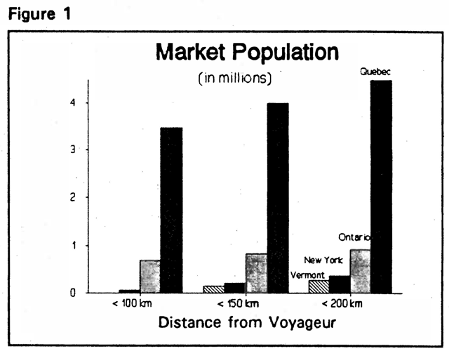
The area within a 200 km radius of Voyageur is the prime market area for park users. Approximately 5.8 million people live within this area, the majority in urban centres. The largest of these cities are Ottawa and Montreal. The market area extends beyond provincial and international borders into distribution of population for Ontario, Quebec, New York and Vermont within the 200 km radius is shown in Figure 1. The majority of park visitors are from the Montreal area.
The park is within an hour’s drive of Montreal, Ottawa and the United States border. Highway 417, bordering the park and linked with Quebec’s Route 40, along with Highway 34 and Highway 138 in Ontario, offer excellent access. With such densely populated urban centres in the vicinity, day use is a major part of park use. Voyageur is accessible by boat from the Ottawa River and the St. Lawrence River. Docking, fuel and supplies, are available a short distance away in Hawkesbury. There are limitations to boating in some areas at Voyageur such as shallow and fluctuating waters and submerged tree stumps. Most boating along Voyageur section of the Ottawa River is by small for day use activities such as fishing and sightseeing.
1.1 Previous planning
Management plans are required for each provincial park. The 1977 master plan (the former term used for management plans) for Carillon Provincial Park is now several years old and Ministry of Natural Resources policy requires a public review. The evolving management plan has been reviewed with the public through public meetings, newsletters, a Preliminary Management Plan and discussions with elected representatives.
The approved Management Plan will provide a planning framework for the next twenty years, with a public review scheduled after ten years.
2. Classification
Voyageur will remain classed as a Recreation Park in Ontario’s provincial park system. This classification recognizes the park’s ability to provide a range of intensive year-round recreational opportunities in an attractive setting within an hour’s travel of major cities. Consideration may be given to a change to Natural Environment classification in future plan reviews.
3. Goal
The park goal is to provide, within the limits of the park’s environmental capacity, year-round recreational and educational activities for the people of Ontario and visitors to the province. It focuses on the needs and interests of large nearby urban populations.
4. Objectives
Voyageur contributes to all four objectives of the provincial park system as follows.
4.1 Protection
- To protect provincially significant elements of the natural and cultural landscape of Ontario.
Continued monitoring and appropriate zoning and management of park areas as outlined in plan aim to protect the park’s significant resources.
Voyageur provides good examples of the vegetation, flora and fauna typical of Site District 6-12. Except for two forest areas, the plant communities are found in no other park in the site district and can be considered regionally significant for this reason. However, the communities found in the park are considered rare within the site district. The park harbours one provincially rare and four regionally rare plant species.
If the separate pockets of wetland such as swamps, wet thickets, wet meadows, marshes and aquatic communities are collectively considered, they form a class 1 wetland. The marshes provide breeding habitat for one regionally significant bird species (Marsh potential nesting and feeding habitat for regionally and provincially significant species, (Red-shouldered Hawk, Northern Pintail, Common Tern) and staging areas for waterfowl.
In addition to the bird species associated with the cattail marsh, eight others considered regionally or provincially significant have been recorded in the park.
Areas of clay soils, a feature not well represented in eastern region provincial parks, are another feature of regional interest. To the extent possible these areas should continue to allow natural regeneration.
The provincially significant Area of Natural and Scientific Interest (ANSI) at the Pointe-Fortune Pit is located on private land east of the park. Geologists have determined that wood samples taken from the pit are more than 40000 years old. If it comes up for sale and are available, the property would be acquired and added to the park thus contributing to the park’s protection objective. See also section 5 Boundary and section 6 Zoning.
Although no evidence has been recorded, it is possible that a portage ran through part of the now flooded by the Carillon Dam. Temporary outposts for repairing canoes were likely set up in the vicinity of the park given the 20 km of rapids comprising the Long Sault which had to be passed.
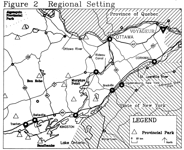
Figure 2: Regional setting map for Voyageur Provincial Park
4.2 Heritage appreciation
- To provide opportunities for the exploration and appreciation of the outdoor natural and cultural heritage of Ontario.
Voyageur, being the first Ontario provincial park inside Ontario’s eastern boundary and one of the few public properties in the area, has great value as an educational resource. There are several stories,.old and new, which can be told at Voyageur about the exploration and development of Canada, early settlements, such as nearby Macdonell house, agricultural methods, the canals, hydro and highway developments adjacent to the park. The park affords a natural setting to tell the story of the Ottawa River: from its use as a travel route by native people, through its importance during the fur trade and voyageur era and on to the construction of the Carillon, Chute-à-Blondeau and Grenville Canals in the early1800s and in this century, its farming use prior to the construction of the Carillon Dam and Power Station and the flooding of part of the TransCanada Highway within the park boundary.
The park and its programmes give many visitors their first glimpse of the Ontario Provincial Parks System and the Ministry of Natural Resources. The impression and the orientation material received at Voyageur will strongly influence opinion about the parks system, the ministry and the province. Voyageur can also serve as an outdoor educational resource for Prescott and Russell counties in association with the Larose Forest, north of Casselman, 60 km west of the park. The study of natural and cultural history and the observation of resource management techniques such as bird banding are examples of the educational benefits of the park.
| Characteristics | Carillon 1990 (now Voyageur) | For All Provincial Parks Surveyed in 1990 |
|---|---|---|
| Age | 25 to 44 (42.7%) | 25 to 44 (39%) |
| Origin (permanent residence) | Province of Quebec (45.7%) | Metro Toronto 19.5%) |
| Type of party | Family (52.7%) | Family (49%) |
| Size of party | 2 persons predominant (36.2%) | 2 persons predominant (41%) |
| Length of stay | 2.7 nights (average) 1 night most common (48.1%) |
3.6 nights (average) 1 night most common (26%) |
| Type of trip | Weekend (53.3%) | Vacation destination (66%) |
| Equipment used | Tent (57.8%) | Tent (49%) |
| Repeat visit (to camp) | No (34%) Yes (66%) |
No (8%) Yes (89%) (at any Ontario provincial park) |
| Role of park (as a destination) | Main Destination (71.9%) | Main Destination (55%) |
| Activities during visit (most popular activities) | Swimming (47.4%) | Swimming, wading (26%) |
| Trip related dollars spent by party within 40 km | $208.92 (small sample size) (average) | $100.01 (average) |
Source: Bibliography references 24 and 38
Change is a dominant aspect in the story of this area. It is evident in its cultural history as well as in its natural history, in the formation of the landscape, in the transition from farm fields to forest cover and to marshlands following the flooding for the Carillon Dam.
4.3 Recreation
- To provide outdoor recreation opportunities ranging from intensity day use to low intensity wilderness experiences.
Voyageur provides the following opportunities annually:
Picnicking 172,048 (39%)
Swimming 92,437 (8%)
Camping 106,251 (17%)
(Shown in brackets is the percent of the Cornwall District supply of recreational opportunities.)32
In addition to these activities which have been selected for measurement in the District Land Use Guidelines32, the park offers several other outdoor recreation opportunities. Among these are hiking, horseback riding, canoeing and boating. waterfowl viewing. fishing and cross-country skiing. Sporting activities such as soccer and baseball are also popular.
Tables 1 and 2 show characteristics of Voyageur park campers and day visitors according to user surveys.
Regionally, Voyageur is important for recreation because recreational opportunities in the surrounding area are limited. However most park visitors are from Montreal and Ottawa. The closest comparable facilities are about 80 to 100 km southwest where the St. Lawrence Parks Commission under the jurisdiction of the Ministry of Tourism and Recreation, operates facilities along Highway 401 and Highway 2.
| Characteristics | Carillon 1990 (now Voyageur) | For All Provincial Parks Surveyed in 1990 |
|---|---|---|
| Age | 25 to 44 (40.7%) | 25 to 44 (36%) |
| Origin (permanent residence) | Province of Quebec (61.7%) | Metro Toronto (8.6%) |
| Type of party | Family (60.2%) | Family (57%) |
| Size of party | 2 persons (19.5%) > 10 persons (15.2%) | 2 persons (30%) 4 persons (23%) |
| Time spent in park | 7.2, hours (average) 21.6% spent 8 hours | 5 hours. (average) 17% spent 4 hours |
| Repeat Visit (day visit) | No (13%) Yes (87%) | No (10%) Yes (87%) (to any Ontario provincial park) |
| Activities (Spent most time doing) | Swimming, wading (38.8%) | Swimming, wading (35%) |
| Trip related dollars spent by party within 40 km | $35.39 (average) | $41.08 (average) |
Source: Bibliography references 24 and 39
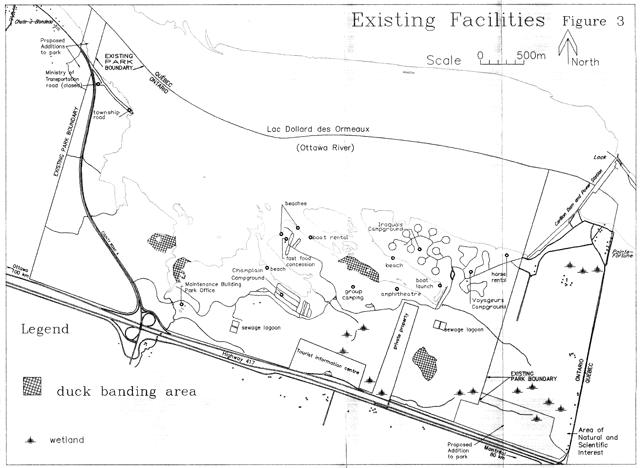
Figure 3: Map of existing facilities for Voyageur Provincial Park
4.4 Tourism
- To provide Ontario residents and visitors from outside the province with opportunities to discover experience the distinctive regions of the province.
Voyageur is a popular provincial park accommodating almost 100,000 visitors in 1991.37
Much of the popularity of Voyageur is attributed to its scenic natural setting. From its campgrounds and beaches to its waterfowl viewing, boating, hiking, skiing and riding trails Voyageur provides a variety of for visitors to discover and experience this area of Ontario.
The park has potential to accommodate increased use. In summer campsites are reliably available. During winter the park has the snow conditions and a trailside environment to provide high quality winter recreation, and could contribute to area tourism with an increased day visit programme.
In 1991, 55% of the total 99,938 visitors to the park were day users. Those who camped overnight in the park numbered 45,128 or 45% of all park visitors.37 The park has a total of 416 developed campsites but because of low occupancy rates fewer sites have been made available for use in recent years.
The park now provides tourist facilities and services including boat rental, horseback riding and a food concession.
The park is within 200 km of almost six million people. As shown in Tables 1 and 2 most daily users and campers are from the Province of Quebec, mainly the Montreal area about 80 km east of Voyageur. Secondary markets are Ottawa-Carleton (17.8% of campers, 6.3% of day users) and Prescott-Russell county (9.3% of campers, 12.7% of day users).
5. Boundary
Voyageur Provincial Park is located in the township of East Hawkesbury, in the United Counties of Prescott and Russell, 18 km east of the town of Hawkesbury and less than one kilometre west of the border of the Province of Quebec. It covers an area of about 1464 ha including an area of the Ottawa River of 641 ha. Highway 417 forms the park’s southern boundary.
A parcel of land which encloses a dike and part of the main park road located partly in Lot 5 and mostly in Lot 4 of Concession 1 of East Hawkesbury Township and comprising 3.061 ha, is excluded from the park. Access from the dam located northeast of the park: to the site of the dike is provided to Quebec Hydro to maintain the dike. No change in the use or jurisdiction of this area is proposed.
There is one private property within the boundary of the park. It is a parcel of approximately 22 ha and is part of the west half of Lot 5, Concession 1, Township of East Hawkesbury. The ministry proposes to add this area to the park, if it becomes available from a willing vendor and funds are available for the purchase. To facilitate links for such things as utility lines between areas of the park on either side of this property and to permit expansion of interpretive and recreational trails this strip of land should be incorporated into the park. See Figure 5.
Prescott and Russell County Road 4 passes through the western end of the park in a north westerly direction toward Chute-à-Blondeau. The main entrance to the park leads easterly from this road. Also leading easterly from County Road 4, closer to the Ottawa River, is a portion of the original route of Highway 17 which remains unflooded at the northwest corner of the park. It is now within the jurisdiction of the Township of East Hawkesbury. Ownership was transferred from the province when other parts of Highway 17 were flooded following completion of the Carillon Dam. A small portion of road linking County Road 4 with the original route of Highway 17 is owned by the Ministry of Transportation. It was closed by an Order in Council. The Ministry of Natural Resources proposes to have ownership of both road properties transferred to Voyageur Provincial Park. See Figure 3.
An area of drowned land adjacent to the west boundary of the park and south of the Ottawa River is part of what is known as the Carillon lands. These lands were acquired in the name of the province for the purposes of the Carillon hydro-electric station. This wetland area together with an extension in the Ottawa River to the provincial boundary are proposed to be added to the park. The 17 ha area is comprised of a total of 9.99 ha north of County Road 4 in the west half of Lot 16, Broken Front Concession, together with 6.77 ha in parts of Lots 16 and 17 on the south side of County Road 4 bounded by the surveyed 140 foot (42.6 m) contour line. See Figure 5.
Figure 4: Market area map of Voyageur Provincial Park
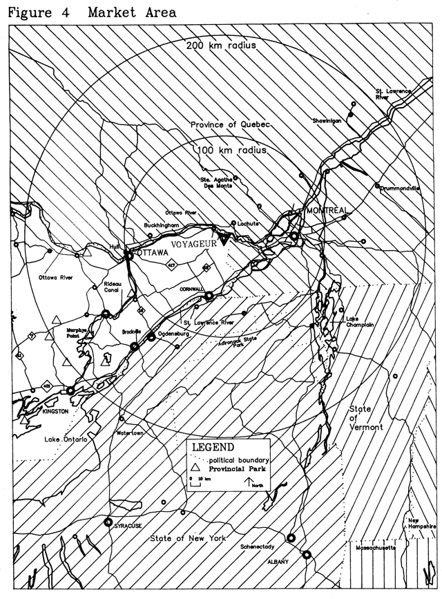
Figure 5: Significant natural features of Voyageur Provincial Park
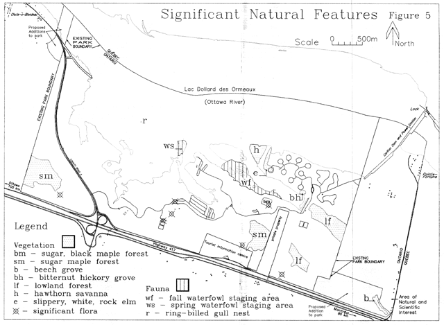
A 47 ha area of Crown land at the southeast comer of the parle will be added to the parIc. It is adjacent to a 13 ha area of private land which has been designated a provincially significant Area of Natural and Scientific Interest known as the Pointe-Fortune Pit. The 13 ha area of the pit is also proposed for addition to the parIc as it becomes available from a willing vendor and as funds are available for purchase. See Natural Environment Zone NE 5 and Figure 6 for more information.
6. Zoning
In order to ensure orderly development and effective management two types of zones have been designated for Voyageur: Natural Environment and Development. This will permit reasonable flexibility in management while ensuring the necessary protection of various areas from incompatible use. The park is divided into one development zone and five natural environment zones which are shown in Figure 6. Proposals for major changes in any zone will require a major review of the management plan.
6.1 Natural Environment Zones
These zones cover a large part of the park and are relatively accessible. Management of all natural environment zones will aim to maintain natural processes such as waterfowl habitat while providing dispersed recreation such as trail use and providing for the managed natural regeneration of woodlands and old fields, as specified in the park’s vegetation management plan.
Figure 6: Proposed boundary and zoning
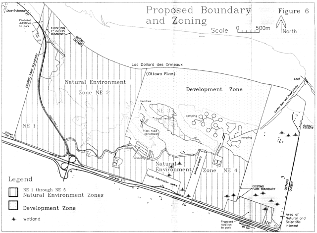
Natural Environment Zone NE 1
This zone comprising 110 ha includes an area of open field and woodland in the west section of the park lying between County Road 4 and the western park boundary. This area has more contrast in topography than the rest of the park. Natural features to be protected in this zone include land formations such as eroded creek channels and raised beach ridges.
Another feature in this zone is a 21 ha locally significant hardwood stand west of County Road 4. The park’s west boundary forms this area’s west limit. This is the largest area of sugar maple dominated hardwoods in the park and is significant because areas not found in other parks in Site District The sugar maple stand will be protected as part of Natural Zone NE 1. It includes the Ontario Ministry of the Environment’s sample plot, established with several others throughout the province in 1985, to carry out a long term assessment of hardwood forest health.
Development will be limited to trails, interpretive facilities and parking. Except in emergency, motorized access will be prohibited.
Natural Environment Zone NE 2
The second Natural Environment Zone NE 2 consists of 496 ha including land immediately west of the development zone and is bordered to the west by County Road 4, to the south by the main park road and to the north by the Ontario-Quebec boundary midway across the Ottawa River. The land portion of the zone is primarily marsh which merges with open meadows. Further inland, the zone consists of open fields. Approximately 17 ha of wetlands on either side of County Road 4 in the northwest comer of the park are also included in this zone. This wetland includes approximately 12 ha of the expansion area described in section 5.
This zone has been specifically designated for the perpetuation of natural processes on the extensive clay soils. Habitat for wildlife particularly waterfowl is another important feature of the zone. Development will be limited to trails , interpretive facilities, minimal parking, and access to water for car-top boats and canoes. Natural Environment Zone NE 2 will also serve as a buffer between the Development Zone and County Road 4.
The facilities and services in the zone are associated with wildlife viewing and interpretation and access to water and are secondary to the protection of wildlife habitat. Nesting, feeding and resting ponds will be maintained for viewing purposes. A boardwalk will be developed to improve waterfowl viewing opportunities.
Natural Environment Zone NE 3
This 30 ha zone forms a pocket to the north of the day use area within the Development Zone and comprised of a 12 ha island and the 18 ha wetland area to the east and south of the island.
The purpose of the zone is to protect the regionally significant fall waterfowl staging areas and to perpetuate natural regeneration on the island. Osprey nesting platforms will be established on the island away from the impact of park visitors.
Natural Environment Zone NE 4
The fourth Natural Environment Zone NE 4, consisting of about 286 ha, lies between the main park road and the park boundary parallel to Highway 417. It extends east from County Road 4 to the west side of the unopened road allowance between Concession 1 Gore, Broken Lot 1 and Concession 1 Lot 1. Approximately 37 ha of the proposed addition is located at the east end of this zone.
The eastern portion of the zone has hills and gullies in contrast to the low wetland in the western section. Generally, the zone shows a checkerboard pattern of open fields and wooded areas of various densities and tree types. This zone includes one of two forest sample plots established in the park by the Ontario Ministry of the Environment. Another is located in Natural Environment Zone NE 1.
The wetland and wooded character of the zone affords good potential for interpretation and outdoor education, and some limited extensive recreation activities such as walking, horseback riding, snowshoeing and cross-country skiing. Additional trails and links between trails will be developed as required and particularly if the private land which bisects the zone becomes available for park use. Another function of this zone is to provide a visual and auditory buffer between the Development Zone and Highway 417.
Natural Environnent Zone NE 5
This 10 ha zone is adjacent to a provincially significant Area of Natural and Scientific Interest (ANSI) known as the Pointe-Fortune Pit, located on private land. Showing pre glacial organic remains, the ANSI has been investigated by several geologists who have determined that wood samples taken from the pit are more than 40000 years old. If acquisition of the 13 ha ANSI is made, Nature Reserve zoning of the combined 22.7 ha area would be most appropriate. This zone also includes an important stand of Beech, Sugar Maple and Butternut.
6.2 Development zone
This zone consists of 549 ha, including land and water areas. It is bounded by the Ontario-Quebec border to the north the park boundary to the east, the main park road to the south and the half-lot line of Lot 10, Concession 1 to the west except where this line bisects the marshy peninsula west of the day use area. This peninsula is part of Natural Environment Zone NE 3.
The Development Zone includes the main part road and administrative area as well as the three campgrounds, the day use area, and the group camping area. Most of the zone is old cultivated fields with scattered woodlots and clumps of bushes of various species. The purpose of the zone is to provide an area for high intensity day-use and camping recreation. Proposed developments include improvements to park entry control facilities, sewage disposal systems, group camping facilities and additional picnic shelters and play areas in the day use area•. As well, a new boat launch and a fishing pier will be built in the day use area. Their locations will be determined in consultation with appropriate staff at local Ministry of Natural Resources (MNR) offices and ensuring that all requirements of fisheries and wetlands legislation and policies have been satisfied.
The main two-way park road runs easterly from County Road 4 to the various activity areas. The park office, maintenance and storage buildings, and sewage lagoons are located south of this road. The two sewage lagoons, shown in Figure 3, serve the three campgrounds and the day use area.
The day use area has parking for 350 vehicles. Other day use facilities include a food outlet, comfort station, a picnic shelter, a boat launch, and two man-made beaches of 381 m and 187 m.
A separate group camping area provides camping areas, an open activity area and vault privies to the east of the main day use area. East of the group camping area is an amphitheatre.
There are 416 auto campsites available, 110 of which have electrical service. Campgrounds are equipped with comfort stations and water supply systems. The Champlain campground has a beach of 54 m and there are 160 m of beach at the Iroquois campground.
There is one boat launching tamp in regular use while two others are less frequently used.
In the northeast comer of the park, near the Portage (formerly Voyageurs) Campground, there is a horseback riding facility with trails located beyond the lowland conifer forest to the south of the campground.
Recreational activities allowed in the Development Zone are: swimming, boating, fishing, picnicking, auto bicycling, horseback riding, creative playgrounds, sports areas, hiking, camping, interpretation and outdoor education, cross-country skiing, snowshoeing and
7. Resource management policies
The park will be managed in accordance with the ministry’s general planning and management policies for recreation class parks. The management of natural and cultural resources will be directed toward protection and heritage appreciation. Resource management strategies will be prepared in cooperation with appropriate local and other MNR staff in keeping with the direction provided in this park management plan.
7.1 Geology and geomorphology
The Carillon Provincial Park Life Sciences report28 prepared by Keddy summarizes the park’s geology and soils as follows. Ordovician limestone of the Oxford formation is found in the northern and eastern portions while grey sandstone of the Rockcliffe Formation is found beneath the remainder of the park.48 The area is mostly covered by surficial material. The Oxford bedrock lies close to the surface locally in the vicinity of the hydro dam48 and a few outcrops of the Rockcliffe Formation occur in Lots 6 and 7 near Highway 417.
The park has a variety of surficial deposits. The eastern portion of the park is covered by glacial till48 which varies from silty to sandy to stony an d often contains large glacial erratics.49 The ancient Ottawa River modified these glacial deposits by scouring out channels. The Champlain Sea deposited offshore clay and silt sediments in some areas and, following the draining of the area, alluvial sands were deposited and organic deposits formed. 43
Loam soils are the most common in the park and include loam, gravelly-sandy loam, fine sandy loam and silt loam. The first two have good drainage while the remainder are poorly drained.49 These are generally associated with the distribution of glacial till. Clay-based soils occur in the eastern portion of the park, are poorly drained and have developed on lacustrine clay deposits. The fine sandy soils have developed over deltaic sand according to vanHaaften.48 The Master Plan29 indicates that they are well drained, but Wickland and Richards48 note that they are imperfectly drained because they occur where the topography is flat as it is in the park or are underlain by clay deposits. The vegetation suggests that portions of the sandy area in the southwest comer of the park have good drainage while other portions have imperfect drainage. In some low-lying areas muck or organic soils are found.
Further evaluation will be carried out on the geology, geomorphology and soils of the park to guide protection of significant features and representative examples such as the pre-glacial organic remains at the Pointe-Fortune ANSI and the extensive clay soils in the west part of the park.
7.2 Vegetation
A vegetation management plan will be prepared. Its objectives will be to retain species and age diversity and representativeness; to allow natural succession and evolution of vegetation communities in the park; to enhance wildlife habitat through reforestation of selected areas with native species; to ensure the safety of park visitors especially in developed areas of the park; to improve the. visual and sound buffer between the highways and the developed areas of the park; to provide for the managed natural regeneration of woodlands and old fields. Permits for agricultural land uses in the park will be discontinued.
Precise locations of important plant species will be recorded. In the vegetation management plan, consideration will be given to management of Purple Loosestrife (Lythrum salicaria), an aggressive introduced wetland species which can threaten wildiife by eliminating suitable native habitat.
Planting will be limited to native species except in development zones where other species may be used if needed to satisfy specific design requirements. In the preparation of the vegetation management plan consideration will be given to the objectives of wildlife management.
Dead and dangerous trees will be removed in high use areas. Vegetation management in the campgrounds will ensure that the ambience of these areas is not impaired. Trees will not be removed for commercial purposes. Wood from trees removed for management purposes may be used at the park.
Mechanical means, rather than herbicides, will be used to control the growth of shrubs along hydro lines and boundaries. All other parts of the park will be allowed to evolve in a natural manner except for development areas.
Control programmes for gypsy moth and other forest pests will be considered and carried out if levels threaten the health or aesthetic value of trees. Control programmes will be restricted to development zones and to other areas of high park use in natural environment zones such as trails.
Control programmes for forest pests such as gypsy moth will be restricted to the use of natural control agents. Upon outbreaks a detailed strategy will be prepared outlining what areas of the park will be targeted for control measures as well as how and when it will be done.
This detailed control strategy will be subject to the provisions of the vegetation management plan and will be based on the most current scientific information available.
The park will continue its cooperation with the Ministry of the Environment in the hardwood forest decline project begun in 1985.
7.3 Fish
The objective of fisheries management in the park is to maintain the health and diversity of fish populations while providing opportunities for recreational fishing.
Fisheries management will be consistent with the Strategic Plan for Ontario Fisheries SPOF II.40 and with the Cornwall District Fisheries Management Plan.31
Park staff will work with appropriate local MNR staff to improve the river environment; to determine the best location for a new fishing pier in the day use area (see sections 6.2 and 9.3); and to maintain naturally reproducing fish populations. The park will continue to provide pedestrian and boat access to the Ottawa River.
The Cornwall District Fisheries Management Plan31 describes the fish community of the Ottawa River as follows.
Yellow perch, walleye and northern pike are less abundant than occur in the St. Lawrence River, and sauger which do not occur in the St. Lawrence, are more abundant than walleye. The growth of walleye, pike and perch is slower than in the St. Lawrence reflecting the poor productivity, limited by water quality and habitat. The populations are generally late-maturing and the age structure, biased to older fish, reflects the low harvest rate. Carp, channel catfish, white suckers and brown bullhead are abundant. The major forage species for walleye, pike and bass consists of yellow perch, crayfish and johnny darters. Muskellunge are present in the Ottawa River but the status is unknown.
Sampling information indicates that sturgeon in the Ottawa River may be declining. These slow growing, late maturing fish are susceptible to over-fishing. The imposition of fish quotas in 1984 may have been adequate to protect the fishery. Water quality and habitat problems are probably also contributing to the decline. This includes the construction of the Carillon Dam which has altered flow patterns and may have prevented access to historical spawning areas. Harvest in the Quebec waters of the Ottawa River, according to the Ministere de Loisir, Chasse et Peche is a few thousand kilograms. The Quebec ministry shares the Ontario Ministry of Natural Resources concern regarding the sturgeon population.
(It is an interesting historical note that American shad were once abundant in the Ottawa River at Voyageur. They apparently disappeared due to beds of sawdust which accumulated on the riverbed from logging activities and due to their inability to pass the dam built at Pointe-Fortune in 1882.45 Every year in early June local residents used to stock these Carillon beef
, as they were called, in sufficient quantity to last a full year.12 )
7.3.1 Commercial fishing
Commercial fishing is licensed on a trial for the period 1990 to 1992. The licence permits gill net and hoop net fishing for bullhead, carp, crappie, catfish, eel, sunfish and suckers in October and November in parts of the Ottawa River within the park boundary. Information on species composition based on regular inspections and records of the commercial and sport fishing catches will be analyzed. If there are no adverse effects on the quality of sport fishing by park users for species such as crappies, sunfish, bullheads, pike, pickerel and sauger; or on the population of turtles, diving ducks, loons and other waterfowl, then the licence may be renewed on an annual basis. Park staff will work with appropriate local MNR staff in monitoring and assessing fishing activities within the park.
7.4 Wildlife
A wildlife management plan will be prepared for the park. It will be consistent with Looking Ahead: A Life Strategy For Ontario. 41 The objectives of the park’s wildlife management plan will be to retain natural species diversity and habitat while providing for recreational activities such as waterfowl viewing which are compatible with the park’s objectives. Hunting is prohibited in the park.
Habitat improvement projects will be considered provided it can be demonstrated that other park values are not threatened and that natural species diversity will be enhanced. For example, osprey nesting platforms may be installed in suitable locations in the park such as the 12 ha island in Natural Environment Zone NE 3. Close monitoring of the impact of beaver on the lowland conifer forests will be carried out. If further impact in these areas threatens natural values, removal of beaver will be considered.
Waterfowl habitat development and maintenance will be considered where it serves to enhance waterfowl populations and waterfowl viewing and where it does not conflict with the perpetuation of other natural values of the zone. Before any habitat improvement work is approved it must be demonstrated that the work will enhance or at least not be detrimental to other natural and cultural values in the area.
7.5 Cultural resources
While no evidence of historic sites or remains has been found within the park, the park’s location on the Ottawa River associates it with Canada’s early exploration and development. Nearby features, such as the historic boundary between Upper and Lower Canada, link the area with its past. Other local events and features include the battle of the Long Sault of 1660, commemorated in a plaque outside the park office; the site of the 1681 fur trading post on Carillon Island; the now submerged rapids and riverside trails of the Long Sault on the Ottawa River; the Macdonell House, east of the park, constructed of stone in 1817 by John Macdonell, a prominent person in the fur trading and logging era; and the now mostly submerged Ottawa River Canals, begun in 1819, which were part of a military waterway built for the defence of British North America. 12
While not within the boundary of the park, the Macdonell House is an important neighbouring feature of historical significance. The stone house, built in 1817 by retired fur trader John Macdonell, was the centre of a commercial establishment which included a stone grist mill, a frame saw mill and domestic buildings. Macdonell served in public office as a judge and later in the House of Assembly of Upper Canada.18 The house was acquired by the Ontario Heritage Foundation in 1978.
Native people, voyageurs fur traders loggers lumbermen and settlers all in turn relied on the Ottawa River as a transportation route. All were confronted with a long and treacherous series of rapids,. the Long Sault Rapids, which once occupied the Ottawa River adjacent to Voyageur Provincial Park. Trails existed along the banks of the river parallel to the rapids. Many journals including those of Samuel de Champlain, tell of troubles in getting past the fast water of the Long Sault.12 A week long battle occurred in 1660 neat the park at the Long Sault of the Ottawa River, involving Adam Dollard des Ormeaux together with 16 Frenchmen and about 40 Hurons battling numerous Iroquois. According to the historical plaque near the park office That spring the Iroquois did not harass the St. Lawrence settlements and in June the first furs in several years reached Montreal…Dollard’s contemporaries regarded him as the saviour of the colony
.
Submerged since 1962 are the three Ottawa River canals (Carillon, Chute-à-Blondeau and Grenville) which were built between 1819 and 1834. These canals together with the Rideau Canal served as part of a military waterway built for the defence of British North America. 12
A picturesque section of the river, its adjacent farm lands and Highway 17 is now submerged by the impounded water of the Carillon Dam which has linked Pointe-Fortune, Ontario and Carillon. Quebec since its completion in 1962.
Further evaluation will be carried out on the cultural resources of the park focusing on the history of land use prior to the construction of the Carillon Dam and links with areas or features in the park. Consideration will be given to the possibility of features submerged by the Ottawa River.
8. Operating policies
A park operating plan will provide staff with the information required to operate the park on a day-to-day basis. In addition to addressing the operations policies which follow, it will cover such topics as safety, budget,sstaffing, and maintenance. It will be consistent with the Provincial Parks Minimum Standards Manual 36 and will be reviewed annually and updated as required.
Park facilities will be operated in accordance with the park operating plan, to the availability of funds. If operating funds are reduced, facilities may be closed or operations curtailed in a manner that will minimize reduction of service to the public, while ensuring that park resources are protected.
8.1 Visitor services
Voyageur will have a seasonal activity programme with regular programming and self-use interpretive, recreation and information facilities. The purpose of Voyageur’s visitor services programme is to introduce visitors from outside the province to the provincial park system and to orient visitors to the park’s and area’s natural and cultural resources, its facilities and programmes; other Ministry of Natural Resources programmes; as well as the attractions, services and recreational opportunities in the surrounding area.
Visitor services management at Voyageur will be directed by a visitor services management plan. The purpose of the plan is to provide background information on park visitors, staffing requirements, and the visitor services programme and to elaborate on how the objectives for information, interpretation and recreation described below will be achieved. It will be based on the format outlined in the provincial policy on visitor services in parks. The plan will be evaluated annually and revised as required.
8.1.1 Information
- to provide public information on the park, the provincial park system and on local area facilities and services.
A high quality bilingual communications programme is essential for the park in keeping with the French Language Services Act.
The public will be introduced to the Ontario Provincial Parks System through mobile displays and information presented at the park, at trade shows and at the Ministry of Tourism and Recreation information centre adjacent to the park on Highway 417.
To inform visitors to the park of the attractions, facilities and services and regulations of the park and the Ontario Provincial Park system, visitors will receive a tabloid upon arrival at the park. The tabloid, which is revised regularly, provides basic information on the park’s various facilities and programmes and on its natural and cultural features. Surrounding area attractions and services are also presented through paid advertisements.
In addition to the park tabloid, descriptive leaflets and/or self-guided facilities for all interpretive trails will be provided.
Using signs, bulletin boards and brochure racks, information will also be provided to visitors on the availability of facilities and services outside the park, special visitor services events and programmes and hours of operation of park offices.
Park staff will maintain good public relations with the local community and the general public through ongoing discussions on park policy and practice. Park staff will keep informed of area tourist initiatives of the Town of Hawkesbury, the townships of East and West Hawkesbury and the United Counties of Prescott and Russell through regular contact and through membership in the tourist federation and Chamber of Commerce.
Visitors will be encouraged to express their comments and suggestions about the park to park staff, either verbally or in writing on the back of park permits. Staff will record and act on appropriate suggestions. Visits to campsites will be carried out on a regular basis by park staff.
8.1.2 Interpretation
- to provide interpretive facilities and programmes.
Interpretive programmes will provide visitors with opportunities to learn about the significance of the park and experience its character. A range of staff-led programmes, self-use facilities including trails, exhibits and publications will help visitors understand the natural and cultural environments of the park. These programmes will be based on the park themes of wetlands and cultural history, particularly the voyageur story, and the park’s role as a gateway to Ontario for from outside the province.
Programmes will be delivered in both French and English languages, using a combination of park staff, other ministry staff and outs ide groups and specialists.
Staff at the park will work with school boards, teachers and other group leaders to encourage increased use of the park to develop an appreciation of the natural and cultural resources of the park. Programmes will focus on the park’s interpretive themes as outlined above.
8.1.3 Recreation
- to provide outdoor recreation facilities and activities
Voyageur provides opportunities for hiking, waterfowl viewing and photography during spring, summer and fall. In winter, ice fishing and cross-country skiing are increasingly popular activities. The many bays and wetland areas along the Ottawa River shoreline in the park provide spring, summer and fall opportunities fishing and canoeing. In addition the park offers soccer and baseball fields and concessions are available during the summer months to rent horses for riding trails in the east side of the park or to rent boats or canoes. All of these recreation facilities and services whether staff-led or self-use will be promoted through the visitor services programme.
8.2 Scientific research
Scientific research by qualified individuals which contributes to the knowledge of natural cultural history and to environmental and recreational management will be encouraged in the park. For example, the Ontario Ministry of the Environment is conducting research into decline in Ontario’s hardwood forests and has established monitoring plots in the park. All such research will follow approved policy for research in provincial parks and will be approved before starting.
8.3 Recreation management
Voyageur Provincial is well used for recreation and it also contains natural environments that are sensitive to human use. To ensure the protection of the park’s natural and cultural resources from overuse and degradation, controls must be placed on inappropriate recreational uses.
8.3.1 Horseback riding
Horseback riding will continue on designated trails only. Horseback riding trails may be expanded in Natural Environment Zone NE 4 south of the Development Zone, provided the private dividing this zone becomes available for park use.
8.3.2 Snowmobiling
Snowmobiles will be permitted to use designated sections of the park roads only. The main use of the park by snowmobiles is as a link between Pointe-Fortune, Quebec and Chute-à-Blondeau, Ontario.
8.4 Marketing
The park’s marketing plan will be reviewed annually and updated as required to reflect the policies which follow.
In the first few years following approval of this management plan park staff will place special emphasis on promoting the new Voyageur Provincial Park name.
Voyageur will be marketed as a family oriented park, serving as a gateway to Ontario and providing a variety of recreational opportunities such as camping, horseback riding, swimming, waterfowl viewing and cross-country skiing. Group picnicking and camping facilities and services will also be promoted.
Park staff will continue to cooperate with tourist associations and with the United Counties of Prescott and Russell, the townships of East and West Hawkesbury and the town of Hawkesbury in distributing and sharing information and promotion.
Current and new ideas to promote the park will be examined annually for effectiveness and practicality.
8.5 Tourism
Guiding the provision of tourism services at the park will be the principle of ensuring the perpetuation of the natural and cultural heritage of the park.
8.5.1 Horseback riding, boat rental, food, firewood
Horseback riding, boat rental, food and firewood services will continue to be provided by private concessions.
8.5.2 Commercial tourism development
Commercial tourism facilities including resort, marina and golf course developments will not be permitted in Voyageur Provincial Park.
9. Development policies
Park facilities will be maintained or replaced as necessary, as budgets allow, to provide continued service to park visitors and to ensure that public safety and environmental protection needs are met.
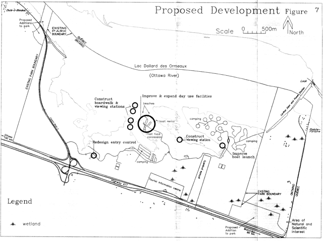
Various park developments are planned to reduce congestion and improve circulation. Other facilities are proposed to increase the level of service in the park. All development will be carried out in accordance with approved site and development plans. Once the development is in place, it will be managed in accordance with the park plan. The following developments will be pursued.
9.1 Entry control
To improve park entry control functions traffic circulation and facility improvements will be made at the park office and gatehouse on the main park toad, following the completion of necessary site planning and architectural designs.
9.2 Boat launch
The existing west of the Portage (formerly Voyageurs) Campground is inadequate and a new launch will be built in the day use area. The surface of the launch, the depth of the launch, traffic circulation and the capacity of the parking area will all be examined in planning for this new facility. (See also section 6.2.)
9.3 Day use area
A site plan will be prepared for the day use area. The plan will assess current vehicle and pedestrian traffic flow in the area and present congestion problems. The plan will incorporate the proposed boat launch noted above.
A review of the existing site plan for the new beach area will be completed and will recommend ways to improve the facilities provided, particularly for groups.
The review will consider the incorporation of additional picnic shelters, a children’s playground area, playing fields for various sports and a fishing pier. (See also section 6.2.)
9.4 Trails
New waterfowl viewing stations, boardwalks and birding trails will be designed and developed in the spring and fall waterfowl staging areas. Careful site planning will ensure that development and visitor use of these facilities is not harmful to the wildlife of the marsh.
Additions to the park’s existing cross-country ski and horseback riding trails are also planned, and will be built contingent on demand.
10. Implementation
The following facility improvements, and resource management strategies will be completed over the 20 year term of this park management plan. Ministry of Natural Resources priorities will determine when projects can be undertaken. All development work will follow approved site plans.
- place new boundary description in regulation
- prepare and implement plans for new boat launch
- prepare and implement plans to redesign entry control
- prepare and implement vegetation management plan
- prepare and implement wildlife management plan
- carry out further research on the Pointe-Fortune Area of Natural and Scientific interest
- carry out further research on the geology, geomorphology and soils of the park
- carry out further research and evaluation of the park’s area’s cultural resources
- prepare and implement site plans and development plans for the day use area
- prepare and implement site plans for hiking, skiing and horse riding trail developments
- prepare and implement site plans for waterfowl banding viewing trails, boardwalks & viewing areas
Figure 7: Proposed development
11. Summary of public consultation
Public consultation associated with this planning project began in August 1989 when a background information and issues tabloid was distributed to a mailing list of more, than 400, comprised of park users, local and provincial interest groups local governments and businesses in the county. Various tourism facilities proposals were presented for comment.
Public comment has been minimal. Of 27 responses received, 16 made reference to the tourism developments proposed. Nine made reference to the golf course proposal. Two of these were in favour of the proposal and seven were opposed. One was in favour of a marina and three were opposed. Two were in favour of a resort and three were opposed. Some comments included suggestions for improvements to visitor services such as more guided hikes and programmes, consideration of using the park as an outdoor learning centre, and providing more facilities and services for group users. The need for improvement to the park’s day use facilities was supported by those who mentioned it as was the proposal for waterfowl viewing stations and trails.
A 1990 survey24 of more than 200 campers and day users at the park showed 45% of campers were opposed while 21% were in favour of the proposal from the private sector to develop golf facilities while 40% of day users were opposed and 24% were in favour.
In December 1991 a bilingual summary of the preliminary management plan30 was distributed to a mailing list of about 150 comprised of park users, landowners, local and provincial interest groups, local governments, members of provincial and federal parliament, businesses, and clubs.
Responses to the preliminary plan summary offered suggestions for minor changes or additional facilities and services.
Various parts of this park management plan address these comments.
12. Plan review and amendment
The Management Plan will be subject to review every ten years and will include public consultation. The review may involve an endorsement of the plan’s policies to ensure their continuing relevance or it may involve evaluation of a proposed change which represents a clear departure from the original plan.
Minor amendments may be made to the plan during the term of the plan. Minor amendments are changes which do not alter the original intent of the plan. These could include a change in emphasis in the visitor services programme, or changes to development concepts as a result of site planning work.
Major amendments deal with changes which may have impact on the public or adjacent land owners, have significant environmental impacts or involve controversial issues. Such major amendments, if considered during the term of the plan, would involve public consultation.
(See also section 8.1.1.)
13. Bibliography
1. Chapman, L. J. and D. F. Putnanl. The Physiography of Southern Ontario. Second edition. Toronto: University of Toronto Press. 1966.
2. Choquette, Robert. Ontario An Informal History of the Land and Its People. Writers: Catherine Price and Maraaret Woollard. Published by the Ontario ministries of Education, and Colleges and Universities ISBN 0-7743-8959-1. Toronto. © 1983.
3. Crowe, R. B., G. A. Mackay and W. M. Blake. The Tourist and Outdoor Recreation Climate of Ontario Vol. 1 and 2. Hull: Ministry of Supply and Services Canada. 1972.
4. Department of Energy, Mines and Resources Canada. Geology and Economic Minerals or Canada. Economic Geology Report No. 1. Edited by R. J. W. Douglas Geological Survey of Canada. 1970.
5. Documents Index Inc. Township Atlas of the U.S. Edited by John L. Andriot. 1987.
6. Federal-Provincial Rural Development Agreement 1970-1975. Department of Agriculture and and Food, Ontario and Department of Regional Economic Expansion, Canada. © 1970.
7. Gadd, N. R., S. H. Richard and D. R. Grant. PreLast-Glacial Organic Remains in Ottawa Valley. From Current Research, Part C. Geological Survey of Canada: Paper 81-1C. Terrain Sciences Division. Ottawa. 1981.
8. Gwyn, Q. H. J. and J. J. L. Thibault. Quaternary geology or the Hawkesbury-Lachute area, southern Ontario. Ontario Ministry of Natural Resources, Division of Mines, Preliminary Map Pl0l0, Geological Series. Toronto. 1975.
9. Heisler, J. P. The Canals of Canada, Occasional Papers in History and Archaeology, No.8. Ottawa: Parks Canada, Department of Indian Affairs and Northern Development 1972.
10. Higginson, M. A. and Brock, J. T. The Village of Hawkesbury, 1808-1888. Hawkesbury. 1961.
11. Hills, O. A. A ready reference to the description of the land of Ontario and its productivity. Ontario Department of Lands and Forests, Division of Research. 1959.
12. Legget, Robert F. Ottawa River Canals and the defence of British North America. Toronto: University of Toronto Press. 1988.
13. Legget, R. F. The Ottawa Waterway. Toronto: University of Toronto Press. 1975.
14. Mackenzie, R. The John Macdonell House, Poplar Villa, Pointe-Fortune, Ontario. Unpublished report, undated.
15. Marshall Macklin Monaghan Limited. Prescott Russell Market Analysis. Unpublished report prepared for the United Counties of Prescott & Russell in collaboration with SOMER, multidisciplinary consultants from Montreal. 1988.
16. McLaughlin, David L. Maple Decline in Ontario: Situation/Research Status Report. Unpublished paper for Maplefest 87, Grand Falls, New Brunswick. Ontario Ministry of the Environment, Air Resources Branch. Toronto. 1987.
17. Morse, Eric W. Fur Trade Canoe Routes of Canada/Then and Now. Revised Edition. ISBN 0-8020-6384-5. Toronto: University of Toronto Press. 1979.
18. Ontario Heritage Foundation. Maison Macdonell House Pointe-Fortune, Ontario. Bilingual pamphlet. ISBN 07743 70491 Publication Number D1147. Ministry of Citizenship and Culture. Toronto. 1982.
19. Ontario Ministry of Municipal Affairs. Municipal Directory 1988. ISSN: 0318-0743. Toronto: Queen’s Printer for Ontario. 1988.
20. Ontario Ministry of Natural Resources. 1974 Day User Survey. Unpublished report. Toronto: Park Planning Branch. 1975.
21. Ontario Ministry of Natural Resources. 1975 Camper Survey. Unpublished report. Toronto: Park Planning Branch. Voyageur Provincial Park: Management Plan 1992.
22. Ontario Ministry of Natural Resources. 1982 Provincial Park Camper Survey Summary Statistical Report. Unpublished report. Toronto: Provincial Parks and Recreational Areas Branch. 1983.
23. Ontario Ministry of Natural Resources. 1982 Provincial Park Day User Survey Summary Statistical Report. Unpublished report. Toronto: Provincial Parks and Recreational Areas Branch. 1983.
24. Ontario Ministry of Natural Resources. 1990 Provincial Park Day User and Camper Surveys Unpublished preliminary reports, May 07, 1991, May 27, 1991 and June 25, 1991. Toronto: Provincial Parks and Natural Heritage Policy Branch. 1991.
25. Ontario Ministry of Natural Resources. A Framework for the Conservation of Ontario’s Biological Heritage. Draft unpublished report. Toronto: Provincial Parks and Recreational Areas Branch. 1980.
26. Ontario Ministry of Natural Resources. A Framework for the Conservation of Ontario’s Earth Science Features. Draft unpublished report. Toronto: Provincial Parks and Recreational Areas Branch. 1981.
27. Ontario Ministry of Natural Resources. Aviation and Fire Management Policy AF.03.01.01. Sault Ste. Marie Aviation and Fire Management Centre. 1989.
28. Ontario Ministry of Natural Resources. Carillon Provincial Park Life Science Resources. Unpublished report prepared by Cathy Keddy. Kemptville: Parks Branch: 1989.
29. Ministry of Natural Resources. Carillon Provincial Park Master Plan. Toronto: Provincial Parks and Recreational Areas Branch. 1977.
30. Ontario Ministry of Natural Resources. Carillon Provincial Park Preliminary Management Plan Summary. Bilingual publication number 4780. ISBN 0-7729-9165-0. Kemptville: Provincial Parks and Natural Heritage Branch. 1991.
31. Ontario Ministry of Natural Resources. Cornwall District Fisheries Management Plan 1987 - 2000. Limited publication. MNR Publication Number 4311. ISBN 0-7729-5580-8. Cornwall: 1989.
32. Ontario Ministry of Natural Resources. Cornwall District Land Use Guidelines. Number 5883. Cornwall: 1983.
33. Ontario Ministry of Natural Resources. Eastern Region Provincial Parks Visitor Services Policies and Guidelines. Manual, limited publication. Kemptville:Parks Branch. 1986.
34. Ontario Ministry of Natural Resources. Ontario Provincial Parks Marketing Research Study. Unpublished report prepared by Laventhol and Horwath, Management Consultants. Toronto: Provincial Parks and Recreational Areas Branch. 1988.
35. Ontario Ministry of Natural Resources. Ontario Provincial Parks Planning and Management Policies. Toronto: Provincial Parks and Recreational Areas Branch. 1978.
36. Ontario Ministry of Natural Resources. Provincial Parks Minimum Operating Standards Manual. Toronto: Provincial and Recreational Areas Branch. 1992.
37. Ontario Ministry of Natural Resources. Ontario Provincial Parks Statistics 1991. Publication # 5628. Bilingual. ISSN 0704-2094. Toronto: Provincial Parks and Natural Heritage Policy Branch. 1992.
38. Ontario Ministry of Natural Resources. Provincial Park Camper Survey Statistical Summary 1990.Unpublished report. Toronto: Provincial Parks and Natural Heritage Policy Branch. 1991.
39. Ontario Ministry of Natural Resources. Provincial Park Day Visitor Survey Statistical Summary 1990. Unpublished report. Toronto: Provincial Parks and Natural Heritage Policy Branch. 1991.
40. Ministry of Natural Resources. Strategic Plan For Ontario Fisheries - SPOF II - An Aquatic Ecosystem Approach to Managing Fisheries. Publication # 3942- 1. Bilingual. ISBN 0-7729-9023-9. Toronto: Natural Resources Information Centre. 1992.
41. Ontario Wildlife Working Group. Looking Ahead: A Wild Life Strategy For Ontario. Ministry of Natural Resources # 4663. ISBN 0-7729-8639-8. Toronto: Resources Information Centre. 1991.
42. Purych, P. and T. J. Burton. IBP checksheets Pria-5-110, Prib-5-lll, Pric-S-112, Prid-5-113. Ontario Ministry of Natural Resources. Kemptville. 1970.
43. Richard, S. H. Surficial Geology, Lachute-Arundel, Quebec-Ontario. Geological Survey of Canada, Map 1577A. 1984.
44. Rowe, J. S. Forest Regions of Canada. Publication No. 1300. Ottawa Canadian Forestry Service, Department of the Environment. 1972.
45. Scott, W. B. and E. 1. Crossman. Freshwater Fishes of Canada. Department of Ichthyology and Herpetology, Royal Ontario Museum. Toronto. In collaboration with Department of the Environment, Fisheries Research Board of Canada. 1973.
46. Sine, P. and P. McIntyre. Wetland inventory and evaluation of Carillon Provincial Park. Ontario Ministry of Natural Resources. 1986.
47. The Economic Planning Group of Canada. Feasibility Study, Marketing Analysis and Site Proposal for a Marina and Equestrian Centre at Carillon Provincial Park. Unpublished consultant’s report prepared for the Ministry of Natural Resources, Cornwall District. 1982.
48. van Haaften, S. Maps and field notes on surficial geology of Carillon Provincial Park. Ontario. Ministry of Natural Resources, Kemptville. 1978.
49. Wicklund, R. E. and N. R. Richards. Soil survey of Russell and Prescott counties. Report No. 33 of the Ontario Soil Survey, Canada Department of Agriculture. Ottawa. 1962.
50. Woerns, N. Earth science inventory checksheet: Carillon Provincial Park. Ontario Ministry of Natural Resources. 1977.