Wabakimi Provincial Park Management Statement
This document provides policy direction for the protection, development and management of Wabakimi Provincial Park and its resources.
Interim management statement
Printed in Ontario, Canada, 1999
Additional copies of this publication can be obtained from:
Wabakimi Provincial Park
Suite 221, 435 James St.
Thunder Bay, Ont.
P7E 6S8
807-475-1634
Approval statement
This Interim Management Statement will provide direction for Wabakimi Provincial Park until a comprehensive Park Management Plan is prepared.
This Statement will provide the basis for the subsequent preparation of the Park Management Plan.
I am pleased to approve this Interim Management Statement.
Signed by:
T. P. Sullivan
Northwest Zone Manager
Ontario Parks
Date: November 2, 1999
Interim Management Statement Amendment: May 5, 2000
Section 3.0 Wildlife Management amended to reflect Ontario Provincial Park Policy and Ontario’s Living Legacy Land Use Strategy.
Background information
| Name: | Wabakimi |
|---|---|
| Class: | Wilderness 155,000 ha. TBA 737,061 ha. |
| MNR District: | Thunder Bay |
| MNR Region: | Northwest |
| Total Area: | 892,061 ha. |
| Site Region: | 3W |
| Site District: | 1 |
| Date In Regulation: | July 19, 1997 |
Life science representation
| Site Type/Landscape Representation | Species/Communities |
|---|---|
|
Associated vegetation patterns typical of Boreal Forest Region. Common vegetation includes black spruce, jack pine, with some poplar and white birch. Bogs and swamps occupy low-lying areas. |
Earth science representation
| Geological Theme | Feature |
|---|---|
| Timiskaming Interstadial Island Arcs and Basins (bedrock theme) |
|
Cultural resource representation
| Theme | Theme Segment |
|---|---|
| Aboriginal Values French Fur Trade (late Archean) Beckwith Site |
Pictographs, spiritual and special sites, campsites, harvest areas, traditional activities, burial sites. Graves, archaeological sites Homestead |
Recreation opportunities
| Day Use | Car Camping | Wilderness/Back Country |
|---|---|---|
| 1,000 | N/A | 120,000 |
Inventories
| Level/Type | Original park area: Completion date | Expanded park area: Inventory done? | Required? |
|---|---|---|---|
| Earth science | 1981 | 1991(small area); 1994(reconn.) | Yes |
| Life Science | 1981 | 1990 (small area) | Yes |
| Cultural/Aboriginal | 1988 | Preliminary Reports | Yes |
| Recreational | 1980 (includes 650,000 ha.) | Majority of new park covered | No |
| Socio/Economic | 1983 | Incomplete | Yes |
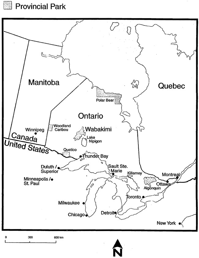
Figure 1: Location
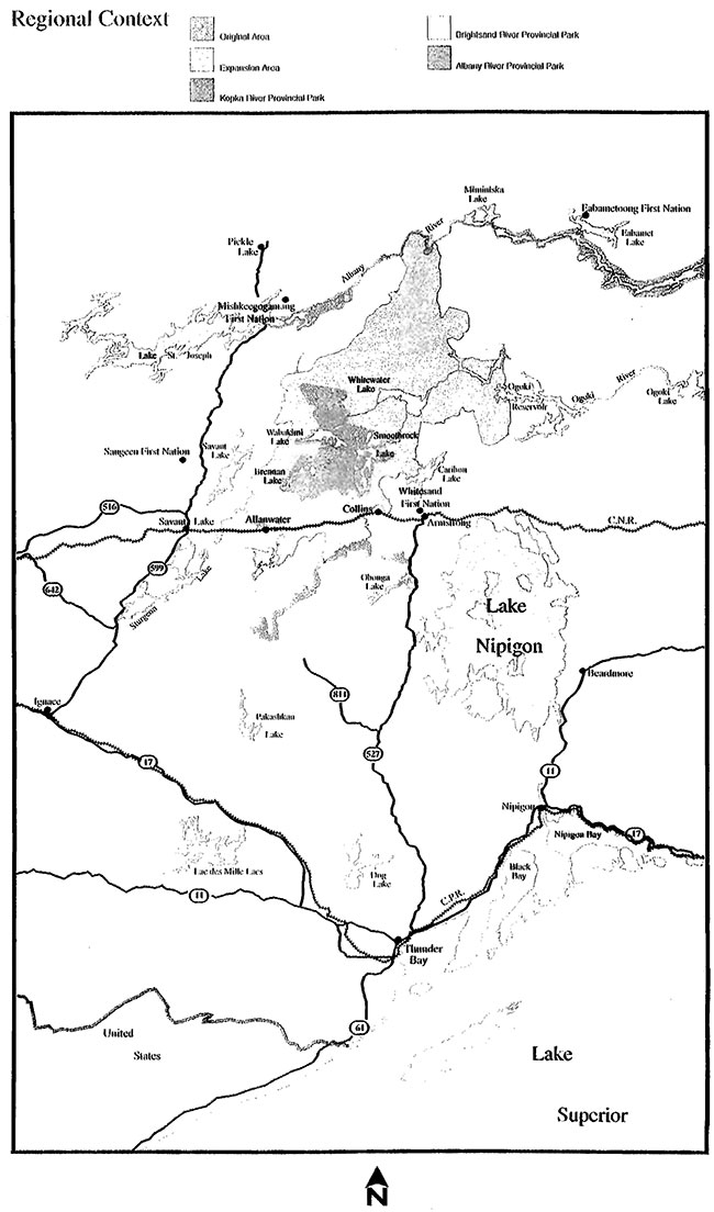
Figure 2: Regional Context
1.0 Introduction
The original Wabakimi Provincial Park was regulated in 1983 as a 155,000 hectare wilderness class provincial park. In 1992, the Ministry of Natural Resources, through the Wabakimi Park Boundary Committee, initiated a review of the park’s size, shape and representation characteristics. This review resulted in a 1997 expansion of over 737,000 surrounding hectares being added to the original park area. The expanded Wabakimi Park, at 892,061 hectares, provides protection and representation for a wide range of natural and cultural heritage values, as well as opportunities for wilderness recreation. Park features include prime woodland caribou habitat, significant earth science features from the days of glacial Lake Agassiz, an important pictograph site, and a variety of scenic canoe routes and remote tourism opportunities including excellent fly-in fishing and hunting. The park includes the traditional use areas of several First Nation and Aboriginal communities.
The Wabakimi Provincial Park Management Plan is scheduled for completion in 2002. The management plan will provide a definition of Wabakimi’s role, significance and classification in the context of the provincial system, provide policy addressing the protection, planning, development and management of park values and resources, and ensure that activities reflect the need for environmental protection and sustainability and are responsive to public interests.
This Interim Management Statement (IMS) will describe some of the significant features in Wabakimi Provincial Park. More importantly, it will provide direction for integrating the protection and management of the park’s resources by describing how existing and proposed activities will be managed within and adjacent to the park until the park management plan is developed.
The original park area will receive interim management that seeks to achieve the intent of its wilderness classification, yet recognizes the existing nonconforming uses. The expansion area will be managed on an interim basis in accordance with the park policies outlined in this document. This approach recognizes the extensive discussions and commitments that were made by the Ministry to permit the continuation of certain activities within Wabakimi Provincial Park. The park management plan will review the classification of the original park area, and determine the classification of the expansion area.
For the purposes of this document, "Adjacent Crown Land" is defmed as that area surrounding the park within which a particular use under consideration could potentially have an impact on park values. Therefore, a specific distance cannot be prescribed.
2.0 Aboriginal interests
The Aboriginal communities and First Nations associated with Wabakimi have expressed a strong desire to work together with Ontario Parks in the development of a Park Management Plan that integrates and constitutes Aboriginal perspective and knowledge. The management plan will determine the ongoing role of Aboriginal interests in the management, stewardship, operations and development of Wabakimi Provincial Park and the mechanisms by which economic development opportunities will be made available to Aboriginal communities.
There is interest on the part of Aboriginal groups to ensure consideration for tourism and other opportunities that may be identified within the park. These discussions deal in part with a desire for assurances of access to economic development initiatives, and the need for adequate time to develop and implement approaches to these initiatives. While the park management plan will be the primary vehicle to address these discussions, Aboriginal proposals which focus on cultural tourism opportunities and non-consumptive uses will be considered prior to it’s completion. The conversion of the existing tourism infrastructure and operations to Aboriginal opportunities will be encouraged. The impacts on park objectives and values and the potential benefits to Aboriginal communities and individuals will be considered in reviewing new development proposals. Joint ventures and business proposals that include relationships with Aboriginals will be considered during the period of the Interim Management Statement.
| Activity | Guidelines - Within Original Park Area | Guidelines - Within Expansion Area | Guidelines - Adjacent Crown Land |
|---|---|---|---|
| 2.1 Land Claims | If land claims are resolved and become legal obligations for Ontario, these obligations will be satisfied through existing processes. | If land claims are resolved and become legal obligations for Ontario, these obligations will be satisfied through existing processes. | N/A |
| 2.2 Traditional Uses | Continue unaffected. | Continue unaffected. | Unaffected |
| 2.3 Economic Development Initiatives | To be considered on a case by case basis. | To be considered on a case by case basis. | To be considered on a case by case basis. |
Aboriginal interests are also addressed within the following sections: 3.0 Wildlife Management, 4.0 Vegetation Management, 5.0 Fisheries Management, 9.0 Cultural Resources, 10.0 Mechanized Travel, 11.0 Commercial Resource Use, 12.0 Existing and New Development and 13.0 Access.
3.0 Wildlife management
Wabakimi Park includes over 550,000 hectares of prime woodland caribou habitat. Woodland Caribou have very different habitat requirements in winter and summer, and often move considerable distances between seasons. The park is sufficiently large to incorporate the winter and summer habitat needs of many of the woodland caribou in the area, although linkages will still be necessary with important habitat not in the park.
Black bears, wolves and moose are common species in the park. Furbearers consist primarily of beaver, marten, fisher, otter, mink, weasel and lynx.
Sport hunting is currently not permitted in the original (wilderness) park area. Where there is demonstrated local public support for hunting in existing wilderness parks, this will be addressed as part of planning for individual parks. Moose hunting will continue to be permitted in the expansion area. Hunting of other species will continue pending resolution via park management planning. Existing Bear Management Area (BMA) Licenses may be renewed, but not transferred. Future renewals will be addressed through park management planning and occur only when conservation principles and public safety can be demonstrated. BMA licenses that have lapsed will not be reinstated.
Trapping by non-aboriginal people will be phased out ofthe original (wilderness) park by January 1, 2010. Trapping by Aboriginal people will continue throughout the park. The transfers of existing traplines, or portions thereof, will be permitted only between or to Status Indians.
| Activity | Guidelines- Within Original Park Area | Guidelines - Within Expansion Area | Guidelines - Adjacent Crown Land |
|---|---|---|---|
| 3.1 Commercial Tourism-based Hunting | Not permitted. Guests at hunt camps which are owned and operated by Status Indians may hunt subject to relevant legislation. | Permitted. | N/A |
| 3.2 Sport Hunting | Not permitted. Where there is demonstrated local public support for hunting in existing wilderness parks, this will be addressed as part of the park management planning process. | Permitted. Moose hunting will be permitted to continue. The Park Management Plan will address the appropriateness of hunting for species other than moose, and may address site-specific issues related to moose hunting. | N/A |
| 3.3Native Hunting | Aboriginal and Treaty Rights unaffected. | Aboriginal and Treaty Rights unaffected. | N/A |
| 3.4 Bear Management Areas (BMSs) | Not Permitted. | Existing BMAs are permitted to continue pending resolution via park management planning. No transfer of licenses. No new BMAs will be issued. | Where possible, consider retention of BMAs adjacent to the park to accommodate potential transfers out of the park. Review and input by Park Superintendent. |
| 3.5 Native Trapping | Continues. | Continues. | N/A |
| 3.6 Non-native Trapping | Permitted, but will be phased out by 2010. | Permitted, pending management plan direction. | Consider relocation options. |
| 3.7 Wildlife Management | Existing activities (e.g. monitoring, aerial surveys) permitted to continue. The need for a Wildlife Management Plan will be addressed in the park management plan. | Existing activities (e.g. monitoring, aerial surveys) permitted to continue. The need for a Wildlife Management Plan will be addressed in the park management plan. | N/A |
4.0 Vegetation management
The park provides good representation of the Central Plateau section ofthe Boreal Forest Region and Site District 3W-1. Ubiquitous forests of black spruce and jack pine, with bogs and swamps occupying low-lying areas typify the vegetation in the park. Poplar and birch stands are less common, but can be found on the elevated backshores and high esker ridges of the park.
Commercial forest operations will not be permitted in the park. However much of the expansion area was previously included in Forest Management Units and therefore some portions had commercial forest operations (access, harvest, and renewal) taking place. Many of those activities were planned with the long-term intent of providing caribou habitat. Some previously harvested areas may require silvicultural work in order to be successfully regenerated to meet caribou habitat requirements.
| Activity | Guidelines - Within Original Park Area | Guidelines - Within Expansion Area | Guidelines - Adjacent Crown Land |
|---|---|---|---|
| 4.1 Vegetation Management (including cutovers) | N/A | Treatment and rehabilitation of cutovers in previously harvested sites will be considered on a case-by-case basis (e.g. planting, herbicide treatment) as per EA Act requirements. | Park Superintendent to participate in Forest Management Planning processes. |
| 4.2 Wild Rice Harvesting | Aboriginal use unaffected. Non-Aboriginal activities to be phased out be 2010. | Permitted pending management plan direction. Aboriginal use unaffected. | N/A |
| 4.3 Logs for Building Construction and Maintenance Purposes | Not permitted for construction purposes. Maintenance needs decided on a case-by- case basis where sources outside of the park are not feasible. | Not permitted for construction purposes. Maintenance needs decided on a case-by-case basis where sources outside of the park are not feasible. | N/A |
| 4.5 Fuel Wood for Camps | Both private and commercial (tourism) camps will be permitted to use only dead wood for fuel. | Both private and commercial (tourism) camps will be permitted to use only dead wood for fuel. | NIA |
| 4.6 Insect/disease Suppression | Pennitted for control of non-native infestations and disease. Biological controls will be used whenever possible. | Permitted for control of non-native infestations and disease. Biological controls will be used whenever possible. | N/A |
5.0 Fisheries management
Wabakimi supports a high quality sport fishery that provides opportunities to fish for walleye, northern pike and lake trout. Fisheries management will be aimed at the maintenance and enhancement of native, self-sustaining fish populations. Specific strategies will be developed in the park management plan, including the possible development of a Park Fisheries Management Plan. Until that time, only strategies identified in the District Fisheries Management Plans will be implemented. Bait fishing will remain as a permitted use for much of the park expansion area, subject to local lake-specific restrictions required to protect park values.
| Activity | Guidelines - Within Original Park Area | Guidelines - Within Expansion Area | Guidelines - Adjacent Crown Land |
|---|---|---|---|
| 5.1 Recreational Sport Fishing | Permitted, subject to Ontario Fisheries Regulations. | Permitted, subject to Ontario Fisheries Regulations. | N/A |
| 5.2 Resort-based Fishing | Permitted, subject to Ontario Fisheries Regulations. | Permitted, subject to Ontario Fisheries Regulations. | N/A |
| 5.3 Fishing by Natives | Aboriginal and Treaty rights unaffected. | Aboriginal and Treaty rights unaffected. | N/A |
| 5.4 Bait-fishing | Permitted, pending park management plan direction. | Permitted, pending management plan direction. | N/A |
| 5.5 Commercial Fishing | Not permitted. | Not permitted. | N/A |
| 5.6 Fisheries Management | Strategies identified within respective District Fisheries Management Plans may be implemented. | Strategies identified within respective District Fisheries Management Plans may be implemented. | Permitted, subject to review and input by the Park superintendent to ensure that park values are not compromised. |
6.0 Lands and water management
The park lies within the Superior Structural Province of the Precambrian Shield, incorporating the transition zone between a northern gneissic belt and a southern greenstone belt. A wide range of intrusive and metamorphic rocks form a subdued, glacially scoured terrain of rock ridges and shallow lake basins. Most of the rock is covered with soils that are extremely thin and often composed of stony and silty sand of granite composition. An extensive dune deposit has been stabilized by vegetation and now consists of groups of low elongated hills.
Significant landforms exist in the park. The Nipigon Moraine, the massive Agutua moraine, the Pikitigushi Spillway and a variety of kames, dune complexes, and peatlands are some of the provincially significant features representing various stages of glacial history.
Wherever possible the park incorporates complete watersheds to maintain watershed integrity.
Commercial mineral exploration and/or extraction will not be permitted.
Generally, no new land disposition will be permitted within the park. The transfer of lands interests and alienated lands will generally be permitted, subject to review by the Park Superintendent. Land disposition and related activity proposals on adjacent Crown Lands will be subject to review and input by the Park Superintendent to ensure that park values are not compromised. (LUP =Land Use Permit)
| Activity | Guidelines - Within Original Park Area | Guidelines - Within Expansion Area | Guidelines - Adjacent Crown Land |
|---|---|---|---|
| 6.1 Water Level Control and Hydro- Electric Generation | Not permitted. | Existing uses and water level fluctuations (e.g. Ogoki reservoir) are permitted to continue within existing operating limitations. No expansion of existing facilities. No new hydroelectric developments permitted. |
No further development or expansion of existing water control structures (e.g. Ogoki reservoir) will be permitted on waterbodies outside the park that may impact on values within the park. |
| 6.2 Aggregate Extraction | Not permitted. | Not permitted. Inventory and rehabilitation of existing gravel pits will be undertaken. |
N/A |
| 6.3 Bait Fish Blocks | Permitted pending park management plan direction. | Permitted, pending park management plan direction. | N/A |
| 6.5 Restricted LUPs for Moose Hunting | Not permitted. | Renewals permitted at existing locations. No new LUPs will be issued. |
N/A |
| 6.6 Trapline Cabins | Permitted for existing traplines. Additional Ireplacement cabins considered on a case- by-case basis. | Permitted for existing traplines. Additional I replacement cabins considered on a case-by- case basis, outside park if possible. | Review and input by Park Superintendent. |
| 6.7 Land Use Permits (Commercial Outpost Camps) | Permitted. No new LUPs to be issued. New developments, expansion of camp capacities and relocations will be considered during park management planning. Improvements that do not increase capacity will be considered on a case-by-case basis. | Permitted. No new LUPs to be issued. New developments, expansion of camp capacities and relocations will be considered via park management planning. Improvements that do not increase capacity will be considered on a case-by-case basis. | Application for new LUPs that could potentially affect park values to be reviewed with the Park Superintendent. Relocation options to be considered. |
| 6.8 Private Land Use Permits | Existing private LUPs permitted, but will be phased out by 2010. No new private LUPs will be issued. | Existing private LUPs permitted pending resolution via park management planning. No new LUPs will be issued. | Review and input by Park Superintendent |
| 6.9 Private lots (Patents) | No new patents will be issued. | No new land disposition. | Review and input by Park Superintendent |
| 6.10 Leases | Existing leases permitted. Private leases to be phased out by 2010. No new leases will be issued. |
Existing leases permitted. No new land disposition. |
Review new requests with the Park Superintendent for potential impacts on the park. |
| 6.11 Licenses of Occupation | N/A | No new Licenses of Occupation will be issued. | Review new requests with the Park Superintendent for potential impacts on the park. |
| 6.12 Mining Claims | Not permitted. | Not permitted. | N/A |
| 6.13 Boat Caches | Existing boat caches permitted. No new boat caches to be established. |
Existing boat caches permitted. No new boat caches to be established. |
Application for new boat caches adjacent to the expanded park to be reviewed with the Park Superintendent. |
| 6.14 Work Permits (i.e. silviculture, shoreline work) | Applications to be reviewed with the Park Superintendent. | Applications to be reviewed with the Park Superintendent. | Work permit applications that have the potential to impact park values to be reviewed with the Park Superintendent. |
7.0 Fire management
Wabakimi contains many values that warrant protection, including numerous fly-in tourism facilities. Since Wabakimi shares a common boundary with the Caribou, Brightsand, Annstrong, Black Sturgeon and Ogoki Forests, there is also concern that fires allowed to bum within the park may cross park boundaries and negatively impact wood supplies and other values outside of the park.
The park also contains large areas of prime woodland caribou habitat, which is important to the survival ofthis vulnerable species. Caribou habitat is an important value both within and outside of Wabakimi, because it plays a significant role in the Caribou Strategy for Northwestern Ontario. Since disturbance may occur within the park, it plays an important role in the determination of forest management planning activities in adjacent forest management units. Fire management strategies for Wabakimi must consider the quality, supply and location of caribou habitat within the park, as well as it’s relationship to, and integration with, caribou habitat supply and the associated caribou mosaics on the adjacent managed landscape.
Forest fires in Wabakimi Park will be actioned according to the Measured Zone fire management strategy for the West Fire Region. All fires will receive a response and that response will be consistent with health and human safety, values at risk, costs for providing suppression action, and the availability of suppression resources.
The park management plan will address the need for a Fire Management Plan.
| Activity | Guidelines - Within Original Park Area | Guidelines - Within Expansion Area | Guidelines - Adjacent Crown Land |
|---|---|---|---|
| 7.1 Fire Management | Within 'Measured' fire zone. Thunder Bay District has the lead fire suppression responsibility. Park values will be considered in fire management strategies; e.g. critical caribou habitat in strategic locations may be considered a high priority for fire suppression. | Within 'Measured' fire zone. Thunder Bay District has the lead fire suppression responsibility. Park values will be considered in fire management strategies; e.g. critical caribou habitat in strategic locations may be considered a high priority for fire suppression. |
Input by park superintendent to ensure that park values are considered. |
8.0 Cultural resources
The park has a number of pictograph sites. These sites will be protected, and specific locations will not be disclosed.
Two historical themes are potentially represented: the French Fur trade and indigenous people.
Wendell Beckwith, who was a scientist, inventor, mathematician and poet, lived as a hermit on Best Island in Whitewater Lake. The concepts employed in the buildings on the site depict the progression of Mr. Beckwith’s efforts to enhance log structures as efficient bush dwellings.
Partnership opportunities to identify, manage and protect the cultural resources ofWabakimi will be encouraged, as will approved archeological fieldwork. The park management plan will address the need for a Cultural Resources Management Plan.
| Activity | Guidelines - Within Original Park Area | Guidelines - Within Expansion Area | Guidelines - Adjacent Crown Land |
|---|---|---|---|
| 8.1 Archaeological, Historical, Pictograph, Spiritual and Special Sites | Known locations will not be released publicly. Measures will be taken as necessary to protect these sites (e.g. restrictions on access or park development). |
Known locations will not be released publicly. Measures will be taken as necessary to protect these sites (e.g. restrictions on access or park development). | N/A |
| 8.2 Beckwith Site | N/A | Existing site will continue to be maintained. No further expansion or development of the site pending management plan direction. |
9.0 Recreation activities
The park has over 1500 km of identified canoe routes providing a variety of travel opportunities ranging from large and small lakes, to rivers and streams.
Excellent whitewater canoeing opportunities also exist. Portages are relatively short, and the park links with several other waterways (Ogoki, Albany, and Brightsand). Good camping exists on most lakes and rivers.
| Activity | Guidelines - Within Original Park Area | Guidelines - Within Expansion Area | Guidelines - Adjacent Crown Land |
|---|---|---|---|
| 9.1 Camping | Permitted. | Permitted. | N/A |
| 9.2 Canoeing | Permitted. | Permitted. | N/A |
| 9.3 Hiking | Permitted. No new trail development |
Permitted. No new trail development. |
N/A |
| 9.4 Mountain Biking | Not permitted. | Permitted. | N/A |
| 9.5 Cross-country Skiing | Permitted. No new trail development |
Permitted. No new trail development. |
N/A |
| 9.6 Park User Permits | Provincial Park Interior Camping Pennits required. | Provincial Park Interior Camping Permits required. | Crown Land Camping Permits required. |
10.0 Mechanized travel
Mechanized travel associated with tourism operations, trapping, wild rice harvesting and baitfishing will continue until further decisions are made through the park management planning process. Mechanized travel by Aboriginal people exercising their Aboriginal or Treaty Rights is unaffected. Also see section 12.0 for guidelines related to Park Access.
| Activity | Guidelines - Within Original Park Area | Guidelines - Within Expansion Area | Guidelines - Adjacent Crown Land |
|---|---|---|---|
| 10.1 Motor Boat Use | Permitted for commercial use, resource harvesting and existing boat cache and property holders only. Decisions on motorboat use and size will be made via park management planning. Use of personal watercraft (''jet-skis") will be resolved via park management planning. |
Permitted. Decisions on motorboat use and size will be made via park management planning, in recognition of the existing tourism use. Use of personal watercraft (''jet-skis") will be resolved via park management planning. |
N/A |
| 10.2 Aircraft Landings | Permitted with an aircraft landing permit. Decisions on aircraft access will be resolved through park management planning. |
Permitted with an aircraft landing permit. Decisions on aircraft access will be resolved through park management planning. |
N/A |
| 10.3 All-terrain Vehicles and Snowmobiles | Not permitted. Exception for landholder and trapline access purposes. | Permitted until decisions on use of existing routes, or development of new trails, is resolved via park management planning. No interim development of new trails. | N/A |
11.0 Commercial resource use:
Commercial use of natural resources other than fish, wildlife or vegetation will be managed as described below.
| Activity | Guidelines - Within Original Park Area | Guidelines - Within Expansion Area | Guidelines - Adjacent Crown Land |
|---|---|---|---|
| 11.1 Resource Use for Railway Purposes | N/A | CNR right-of-way is excluded from the park. Park expansion has no impact on existing railway operations. Review any railway activities that may impact on the park on a case-by-case basis. | Review any railway activities that may impact on the park on a case-by-case basis. |
| 11.2 Native Eco- tourism | Use or identification of native cultural sites for eco-tourism purposes may be permitted with the involvement and support of the interested First Nation(s). | Use or identification of native cultural sites for eco-tourism purposes may be permitted with the involvement and support of the interested First Nation(s). | N/A |
12.0 Existing and new development
There is currently very little development within Wabakimi Provincial Park that is not directly tied to the remote tourism industry. The disposition of Crown land has been frozen in the area between Armstrong and Caribou Lake, to permit planned development. Generally, no new development will occur within the park, pending completion of the park management plan. The exception to this is that Aboriginal economic development proposals may be considered.
| Activity | Guidelines - Within Original Park Area | Guidelines - Within Expansion Area | Guidelines - Adjacent Crown Land |
|---|---|---|---|
| 12.1 Roads (including bridges and culverts) | Not permitted. | New roads not permitted pending decisions in park management plan. The need for physical removal, abandonment, closure and/or rehabilitation of roads and bridges will be considered on a case-by-case basis, subject to EA requirements, when no longer required for silviculture purposes. |
Plans for road construction, maintenance, closure, or abandonment to be reviewed by the Park Superintendent to ensure that park values are not compromised. |
| 12.2 Signage | Permitted. | Permitted. | N/A |
| 12.3 Campsites | Existing sites permitted. | Existing sites permitted. | N/A |
| 12.4 Boat Launch Ramps | N/A | No new development pending resolution via park management planning. | Review and input by the Park Superintendent to ensure that park values are not compromised. |
| 12.5 Docks | Not permitted, except for tenure holders. | Not permitted, except for tenure holders. | N/A |
| 12.6 Parking | N/A | No new developments. | Review and input by the Park Superintendent to ensure that park values are not compromised. |
| 12.7 Waste disposal Sites | No new sites to be established pending resolution via park management planning. -Existing sites with MOEE Certificates of Approval permitted. | No new sites to be established pending resolution via park management planning. -Existing sites with MOEE Certificates of Approval permitted. | Review and input by the Park Superintendent to ensure that park values are not compromised. |
| 12.8 Portages and Trails | Existing portages and trails pennitted pending resolution via park management planning. No new trails to be built. | Existing portages and trails pennitted pending resolution via park management planning. No new trails to be built. | N/A |
| 12.9 Existing Tourism Facilities | Pennitted. Improvements that do not increase capacity will be considered on a case by case basis. | Pennitted. Improvements that do not increase capacity will be considered on a case by case basis. |
Review and input by the Park Superintendent to ensure that park values are not compromised. |
| 12.10 New Tourism Facilities | Not pennitted pending resolution via park management planning. Aboriginal economic development proposals may be considered. | Not pennitted pending resolution via park management planning. Aboriginal economic development proposals may be considered. | Review and input by the Park Superintendent to ensure that park values are not compromised. |
| 12.11 Whitewater Lake Community | N/A | Traditional uses are unaffected. No new development pennitted pending resolution of federal land claim process. | N/A |
13.0 Park access
Access to the park can be gained at many locations and by several different methods. Until access zones are established through the park management planning process, the methods and locations of access will be managed as described below. The intent will be to have planned access development that balances the need for the protection of significant features and the park experience, with the need for recreational and tourism access, as well as access to resources adjacent to the park (timber and minerals). Access by Aboriginal people exercising their Aboriginal or Treaty Rights is unaffected. Also see section 9.0 for guidelines related to mechanized travel in the park.
| Activity | Guidelines - Within Original Park Area | Guidelines - Within Expansion Area | Guidelines - Adjacent Crown Land |
|---|---|---|---|
| 13.1 Road Access | N/A | Access road planning will defer to the park management planning process Existing road access will be permitted to continue, pending resolution via park management planning. No new or additional interim access to be developed. The maintenance of in-park roads will be determined on a case by case basis. All of above are subject to road closure, removal, abandonment and rehabilitation, which may occur prior to completion of the park management plan as per EA Act requirements. |
Plans for road construction or maintenance will be reviewed by the Park Superintendent to ensure that park values are not compromised. Restrictions may apply to road use and locations to prevent unwanted access. No new access to the park will be created from roads adjacent to the park. Access road planning will occur during forest management planning processes. All of above are subject to road closure, removal, abandonment and rehabilitation, which may occur prior to completion of the park management plan as per EA Act requirements. |
| 13.2 Aircraft Access | Permitted for tourist outfitters and private (recreational) aircraft via an aircraft landing permit. Decisions on aircraft use or landing locations will be resolved through park management planning. |
Permitted for tourist outfitters and private (recreational) aircraft via an aircraft landing permit. Decisions on aircraft use or landing locations will be resolved through park management planning. |
N/A |
| 13.3 Boating and Portaging | Permitted. Decisions on boat access locations will be resolved through park management planning. | Permitted. Decisions on boat access locations will be resolved through park management planning. |
Restrictions may apply to road use and locations adjacent to the park to prevent the creation. of unplanned boat access. |
| 13.4 Rail Access | Park access by rail is permitted. | Railway access is permitted | N/A |
| 13.5 Designated Access Points | N/A | Existing access points will be inventoried and permitted pending resolution via park management planning. No development of new access points pending resolution via park management planning. |
Desirable access point locations and facility development will be resolved via park management planning. |
| 13.6 Aboriginal Access | Unaffected. | Unaffected. | N/A |
14.0 Research
Research by qualified individuals, which contributes to the knowledge of the natural and cultural history of the park, or to environmental or recreational management, will be encouraged.
| Activity | Guidelines - Within Original Park Area | Guidelines - Within Expansion Area | Guidelines - Adjacent Crown Land |
|---|---|---|---|
| 14.1 Ongoing and new research to support management planning | Permitted if no conflict with park values, and if consistent with the Ontario Parks Research and Information Strategy and policy. Specific research projects will be encouraged to support management planning. | Permitted if no conflict with park values, and if consistent with the Ontario Parks Research and Information Strategy and policy. Specific research projects will be encouraged to support management planning. | Districts will review/approve on a case-by-case basis with input from the Park Superintendent. |
15.0 Client services
Various methods will be used to aid visitors in recognizing, using and enjoying the recreational and education potential of the park, in a responsible and ethical manner. Wabakimi presents a significant opportunity for nearby communities, First Nations, residents and local businesses to work together, and with various government agencies, to develop suitable information and products that are beneficial to the park and it’s partners.
| Activity | Guidelines - Within Original Park Area | Guidelines - Within Expansion Area | Guidelines - Adjacent Crown Land |
|---|---|---|---|
| 15.1 Park Leaflet, Map, General formation | Information will be developed for public distribution as funding and partnerships permit, utilizing a variety of methods. | Information will be developed for public distribution as funding and partnerships permit, utilizing a variety of methods. | N/A |
16.0 Marketing
Promotion of this internationally renowned park will occur as opportunities permit.
| Activity | Guidelines - Within Original Park Area | Guidelines - Within Expansion Area | Guidelines - Adjacent Crown Land |
|---|---|---|---|
| 16.1 Partnerships and "Friends of' Organizations | Permitted and encouraged. Opportunities for joint development and marketing will be pursued. |
Permitted and encouraged. Opportunities for joint development and marketing will be pursued. |
Opportunities for joint development and marketing will be pursued. |
17.0 E.A. requirements
Until such time as the Class Environmental Assessment for Provincial Park Management is approved, all projects and activities associated with the interim management of Wabakimi Provincial Park will be reviewed using the relevant E.A. Exemption Order(s).
18.0 Summary
This Interim Management Statement for Wabakimi Provincial Park is much more detailed than that which exists for most other parks. Given the quantity and quality of discussions that have taken place about the park, and the public desire to have the resulting discussions documented, a detailed document like this one is necessary and appropriate.
19.0 Sources/References:
Adams, N. Cultural Resources Pre-field Report, Cataraqui Archeological Research Foundation, Kingston, Ontario, 1988
Geomatics International, Assessment of Earth Science Features and Processes in and surrounding Wabakimi Provincial Park, (by Greg Wickware and Daryl Cowell), Burlington, 1991
Kor, P. A Reconnaissance Inventory and Evaluation of Surficial Earth Science Features: Wabakimi Provincial Park Expansion Study Area, MNR Terrestrial Systems Branch, 1994
MNR, Nipigon District Land Use Guidelines, Nipigon, 1983
MNR, Ontario Provincial Park: Planning and Management Policies, 1982
MNR, West Patricia Land Use Guidelines (for Sioux Lookout portion), Kenora, 1983
MNR, Wabakimi Provincial Park: Background Information (Preliminary Draft), 1991
MNR, Wabakimi Provincial Park: Interim Management Statement, 1988
MNR, Wabakimi Provincial Park: Interim Management Statement, 1991
Noble, T. Wabakimi Provincial Park: Life Sciences Pre-field Survey, 1988
Scott, N. Whitewater Candidate Wilderness Area: A Summary of Recreation Potential, Nipigon District, 1980
Wabakimi Boundary Committee, Draft Final Report of the Wabakimi Park Boundary Committee, January 1995
Wickware, G. Earth Science Pre-field Survey ofWabakimi Provincial Park, Wickware and Associates, Burlington, Ontario