Waubashene Beaches Provincial Park Management Statement
This document provides policy direction for the protection, development and management of Waubashene Beaches Provincial Park and its resources.
January, 1994
Regional Director’s approval statement
This Interim Management Statement will provide Interim direction for the management of Waubaushene Beaches Provincial Nature Reserve until a comprehensive Park Management Plan is prepared.
This Statement will provide the basis for the subsequent preparation of the Park Management Plan.
I am pleased to approve this Interim Management Statement for Waubaushene Beaches Provincial Nature Reserve.
Approved and signed by:
D. Johnstone
Regional Director
Southern Region
Background information
- Name: Waubaushene Beaches Provincial Park
- Proposed class: Nature Reserve
- M.N.R. parks zone: Midhurst
- M.N.R. region: Southern Region
- Total area (ha) 34
Land: [no information provided]
Water: [no information provided] - Site region: 6E
- Site district: 6-6
- Date in regulation: Reg. 245/69
Enlarge Figure 1: West Sandy Island Provincial Nature Reserve (PDF)
Targets
1. Life science representation
- site type/landscape unit: Nipissing Shorebluff System
features:- Shorebluff slope and rim terrace complex
- Successional pasture and meadow spp.
- site type/landscape unit: Post-Nipissing Foreshore Sand Plain and Embayments
features:- Shorebluff and embayment complex
- Fen meadow, scrub and grove spp.
- site type/landscape unit: Post-Nipissing Foreshore Plain Depression
features:- Lagoonal depression
- Cedar-willow-dogwood grove
- site type/landscape unit: Post-Nipissing Foreshore Sand Plain
features:- Fescue-dominated meadow
- Early successional groves and thickets
- site type/landscape unit: Backslope Enpondment Basin
features:- Pond to shore meadow
- Wetland aquatic, meadow, scrub fringe and forest fringe
- site type/landscape unit: Disturbed Backslope
features:- Open barrens, disturbed forb meadows, dogwood scrublands
2. Earth science representation
- geological theme: Glacial Lake Algonquin
features:- Shoreline, raised beaches
- geological theme: Post-glacial Lake Nipissing
features:- Shorebluffs; terrace plain
3. Cultural resources representation
- theme: Early Historic Huron, circa 1600-1620
theme segment:- Waubaushene Beach Ridge Site.
An ancient native village with middens.
- Waubaushene Beach Ridge Site.
4. Recreation opportunities
- day use: hiking, viewing
- car camping: N/A
- wilderness/back country: N/A
Inventories
| Level/type | Earth science | Life science | Cultural | Recreational | Other |
|---|---|---|---|---|---|
| Reconnaissance completion date | [no information provided] | 1983 | [no information provided] | [no information provided] | [no information provided] |
| Detailed completion date | [no information provided] | [no information provided] | [no information provided] | [no information provided] | [no information provided] |
| Required? | detailed | [no information provided] | Historical and Archaeological reconnaissance | [no information provided] | [no information provided] |
Management guidelines
I Land tenure
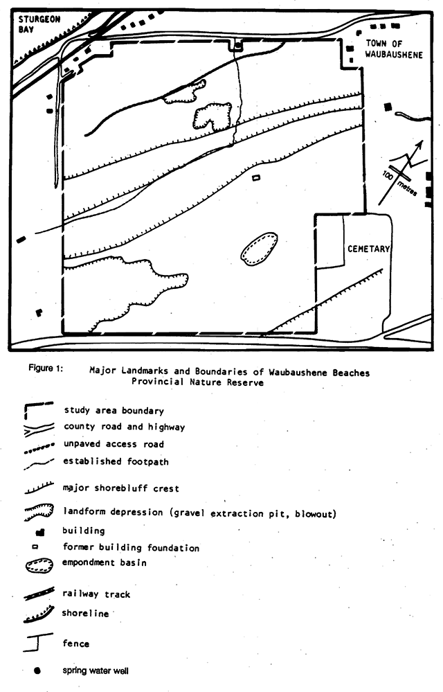
The Crown presently owns a total of 34 hectares which was regulated under the Provincial Parks Act in 1969 as Waubaushene Beaches Provincial Nature Reserve (Ont. Reg. 245/69).
Guideline
The Reconnaissance Biological Inventory of Waubausbene Beaches Provincial Nature Reserve recommended that the park retain its status as a Nature Reserve class provincial park.
Bell Canada has guying anchors situated on park property for two angle poles located along the north side of Highway 12 between the west entrance to Waubaushene and Neekawanis Road (Lot 10, Concession 10, Tay Township).
Guideline
The present permission for Bell Canada will continue.
II Land acquisition/disposition
The Reconnaissance Biological Inventory of Waubausbene Beaches Provincial Nature Reserve states that the shoreline features associated with the park include a moderate 1.5 metre post-Nipissing bluff which is referred to 88 the Waubaushene stage. This stage is located just outside the northern boundary of the park, and the possibility of acquiring a portion of this level should be considered.
Guideline
Acquisition of a portion of the Waubaushene stage will be considered in the park management plan review.
III Existing development
Existing development is limited to an established footpath.
Guideline
The existing faculties will not be maintained on a regular basis.
IV Proposed development
Future development may include a limited number of parking spaces, washrooms and a small picnic site off Highway No. 12 near the south corner of the park. Future development may also include a formal trail system with interpretive panels.
Guidelines
Further development (excluding those related to public health and safety) will not be undertaken prior - to completion of a park management plan.
A trail plan should be completed prior to preparation of a park management plan.
V Recreation activities
No visitation figures, are recorded.
While there are no access or interpretive facilities present, incidental us currently occurs from a neighbouring religious camp and common-use well site for viewing purposes. Illicit picnics and "partying" occur within the northwest area of the park in the cedar grove and in the former gravel pit (sand blowout). There is the occasional misuse of the foot trails by mountain bikes, trail bikes, all-terrain vehicles and snowmobiles, particularly in the vicinity of the two gravel pits and along the crest and face of the shorebluff.
Guidelines
Steps which may be taken to exclude inappropriate, destructive uses include the following:
- increase vigilance patrols about the area by O.P.P., Ministry staff and/or local cooperative residents (“Park Watch”),
- sign the area adequately indicating permitted and excluded uses, with consideration for educational messages about protection objective and the areas significance and sensitivity,
- establish fencing systems around those points which suffer from chronic vandalism or which allow inappropriate intruders access (e.g. at the well site).
VI Commercial activities
Guideline
No commercial activities will be permitted.
VII Native interests
An ancient native village site exists in the park which may be of local interest.
Guideline
Local native communities will be consulted during the park management planning process and prior to any archaeological studies or inventories of the site.
VIII Natural resources
The display of the various shorebluffs is greatly enhanced by the current open meadow vegetation in its central portions. However, successional trends here are towards increased forb, scrub and grove cover which will steadily obscure the contours of the shorebluffs and terraces. Vegetation management to maintain the present open cover may be desirable for any future interpretation of the natural features and maintenance of the scenic views, at least In the central portions of the shorebluff complex.
Guidelines:
Vegetation management may be utilized to maintain the desired scenic views. The use of broadleaf herbicides will not be considered. Those forested and sucessful grove portions already existing at the southern and northern portions of the complex should be retained to illustrate the range of successional communities, and hence should not be so managed.
A vegetation management plan should be prepared In advance of any actual management activities.
The small gravel pit cut into the base of the Nipissing bluff has been stablized to some extent by natural regeneration.
Guidelines:
The pit face should be monitored over time to determine whether further stabilization and rehabilitation are required, as part of a vegetation management plan.
The bluffs are cut into unconsolidated material and are susceptible to slumping and gullying processes if the vegetative cover is disturbed.
Guidelines:
Subject to future approved development supported by a trail plan and park management plan, a set of stairs and/or a side slope trail down this slope may be carefully designed and located to direct foot traffic.
The low relief post-Nipissing ridges below the main Nipissing bluff are composed of fine-grained sands and are open to erosion at the present time, with several blowouts in various stages of development.
Guidelines:
This site should be carefully monitored and possibly temporarily fenced off to prevent further erosion and encourage natural or assisted revegetation.
As a scientific and interpretive site, Waubaushene Beaches ranks highly on provincial scale. This site was identified as a provincially significant site in a study on raised beaches of southern Ontario. The open pasture surface of the property enhances the visibilty of the shoreline features. Also, the uplift curves of glacial Lake Algonquin are based on the elevation of the shorelines in Waubaushene Beaches, and are even more critical in the extension of these curves to Northern Ontario. Recent studies indicate that a hinge zone for Algonquin shorelines may exist in the head of Georgian Bay, further enhancing the scientific value of this site.
Guidelines:
Interpretation of the site will not be undertaken until after completion of a park management plan.
This site could serve as a datum point for a long-term monitoring program of post-glacial uplift.
A detailed earth science inventory should be undertaken prior to the preparation of a park management plan.
Waubauahene Beaches has been subjected to considerable disturbance in the form a forest clearing, grazing, sand and gravel extraction and the use of motorized recreation vehicles (snowmobles all-terrain vehicles and motorbikes).
Guidelines:
All of the above activities should be posted and banned in the Nature Reserve, with the possible exception of some vegetation management
IX Cultural resources
A one to two hectare archaeological site, known as the Waubaushene Beach Ridge Site, is located within the boundary of the Nature Reserve. The site is situated along the Algonquin beach terrace below the maJor promontory of the area. The site had been ploughed and one midden was slightly disturbed by pot hunting and fence construction (pre-1979).
Initial research in 1979 identified three midden deposits, but this might not indicate the complete site area. A large portion of the site. which was not extensively tested, extends beyond the Nature Reserve boundary. The site was tentatively placed In early Historic Huron, circa 1600-1620.
Guidelines:
Future management planning for the park should include preservation of the site.
Historical and archaeological inventories are required, prior to completion of a park management plan, in consultation with the Ministry of Culture and Communications and local native communities.
The site will be protected from disturbance
X. Client Services
In the foreseeable future, no additional facilities will be provided.
Information
Basic information about the park, including photographs, maps and text was produced in leaflet form as one of a series from the publication Provincial Nature Reserves in Ontario..
Guidelines:
Basic information about the park may be updated and reproduced as required.
Education - Guidelines:
Prospective visitors may be made aware of the vulnerability of the Nature Reserve’s resources to damage from inappropriate uses in any publications and/or signs produced for the park.
Interpretation - Guidelines:
An interpretive program is not required at this time. The need for, and type of interpretive program will be determined during the parkm anagement pIanning process.
XI. Research
Guidelines:
The following studies should be conducted as priorities and funding permits:
- earth science
- cutural/historical/archaeological
- faunal
This site could serve as a datum point for a long term monitoring program of post-glacial uplift (e.g. through university research)
XII. Marketing
Guideline
There are no plans in the near future to promote use of the Nature Reserve apart from general information provided to the public regarding provincial nature reserves.
XIII References
Blachut, S. Earth Science Inventory Checklist; Waubaushene Beaches Nature Reserve. Division of Parks. Ontario Ministry of Natural Resources. Toronto, Ontario, 1977.
MacDonald, I.D. A Reconnaissance Biological Inventory of Waubaushene Beaches Provincial Nature Reserve. Central Region Parks. Ontario Ministry of Natural Resources, Richmond Hill, Ontario, 1983.
Ontario Ministry of Natural Resources. A Summary of the Earth Science Areas of Natural and Scientific Interest In Huronia District. Central Region Parks, Richmond Hill, Ontario, 1983.
Ontario Ministry of Natural Resources. Huronia District Land Use Guidelines. Midhurst, Ontario, 1983.
Ontario Ministry of Natural Resources. Provincial Nature Reserves in Ontario. Parks and Recreational Areas Branch, Toronto, 1981.