West Montreal River Provincial Park Management Statement
This document provides policy direction for the protection, development and management of West Montreal River Provincial Park and its resources.
Interim Management Statement
2007
Approval statement
I am pleased to approve this Interim Management Statement for West Montreal River Provincial Park. Ontario’s Living Legacy Land Use Strategy (1999) identified this area as a waterway class provincial park. This park was regulated under the Provincial Parks Act in May of 2002 (O. Reg. #147/02).
This Interim Management Statement provides direction for the protection and management of West Montreal River Provincial Park.
Signed by:
Paul Bewick
Zone Manager
Northeast Zone
Ontario Parks
Date: January 19, 2007
1.0 Introduction
West Montreal River Provincial Park is located approximately 60 kilometres to the west of Kirkland Lake and is only a few kilometres from the Town of Matachewan (Figure 1) in Baden, Powell, Cairo, Yarrow, Kimberly, Doon, Rankin, Morel, Knight, VanHise, Haultain, Tyrrell, Milner and Nicol townships (Figure 2). The park is located along the West Montreal River, between the Whitefish and East Whitefish Lakes Sandy Till Upland Conservation Reserve to the north and Highway 560 to the south.
This park includes two arms of the West Montreal River. The western arm of the river at its northernmost extremity is looped into the Great Northern Bend where it joins the Matachewan Lake segment of the Montreal River. The West Montreal River encompasses a series of lakes including Metikemedo, Mistinikon, Penassi, Sisseney, and Obushkong. This 7,259-hectare waterway class park (P1715) was regulated on May 8, 2002 (O. Reg. #147/02) under the Provincial Parks Act to protect an outstanding recreational water route and to provide high quality recreational and educational opportunities.
1.1 Objectives
West Montreal River Provincial Park will be managed consistent with the four objectives for provincial parks:
Protection: To protect provincially significant elements of the natural and cultural landscapes of Ontario.
Recreation: To provide provincial park outdoor recreation opportunities ranging from highintensity day-use to low-intensity wilderness experiences.
Heritage Appreciation: To provide opportunities for exploration and appreciation of the outdoor natural and cultural heritage of Ontario.
Tourism: To provide Ontario’s residents and out-of-province visitors with opportunities to discover and experience the distinctive regions of the Province.
2.0 Management context
The purpose of this Interim Management Statement (IMS) is to provide direction to ensure the custodial management of park resources. Future park planning may be undertaken as required to provide direction on significant decisions regarding resource stewardship, development, operations, and permitted uses.
Park management will follow direction from:
- Provincial Parks Act (1990) and regulations
- Ontario Provincial Parks Planning and Management Policies (OMNR 1992)
- Crown Land Use Policy Atlas (OMNR 2004a)
- Ontario’s Living Legacy Land Use Strategy (OMNR 1999) and policy clarifications (OMNR 2000), amendments, and related direction
In addressing custodial management obligations to protect park values and ensure public health and safety, Ontario Parks will ensure that policy and Environmental Assessment Act (1990) requirements are implemented.
Figure 1: Regional Setting
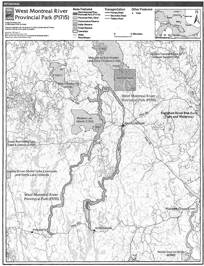
Enlarge Figure 1: Regional Setting
Figure 2: Park Boundary
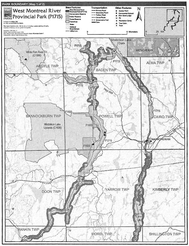
Enlarge Figure 2: Park Boundary
Figure 2: Park Boundary (continued)
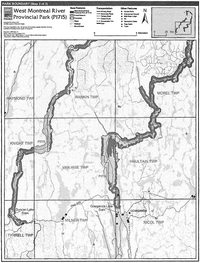
Enlarge Figure 2: Park Boundary (continued)
2.1 Environmental Assessment
As part of the Ontario Ministry of Natural Resources (MNR), Ontario Parks is a public sector agency that is subject to the Environmental Assessment Act. Park management will be carried out in accordance with legislation, policies and guidelines as required under MNR's A Class Environmental Assessment for Provincial Parks and Conservation Reserves (OMNR 2005).
3.0 Park features and values
The West Montreal River Provincial Park stretches from Highway 560 just west of Gowganda northward, makes a loop north of Lake Matachewan and then follows the river south back down to Highway 560. The park protects approximately 110 kilometres of the West Montreal River and Montreal River. The park is in the southern portion of Ecodistrict 3E-5.
3.1 Geological features
The bedrock of West Montreal River Provincial Park is in the central part of the Abitibi Subprovince, of the Archean Superior Province.More than half of the waterway is underlain by the Archean supracrustal and plutonic rocks and the rest by the Proterozoic Huronian Supergroup (Cobalt Group/Gowganda and Loraine formations) clastic assemblages (Frey and Duba 2002).
Within the Ontario Provincial Park system, the geological features of the West Montreal River Provincial Park have regional significance in representing the Archean felsic metaplutonic and supracrustal (metavolcanic and metasedimentary) and Paleoproterozoic clastic metasedimentary components of the central Abitibi Subprovince in the Archean Superior Province. The surficial geology is locally significant (Frey and Duba 2002).
3.2 Biological features
The area is characterized by intolerant hardwoods interspersed with poor to rich coniferous, red maple, mixed pine uplands, black spruce, and rock outcrop communities lining the waterway with many tributaries entering the river system creating numerous tall shrub thickets and open wetlands. (Atkins 2003).
This waterway park is a linear series of lakes (110 km protected waterway) making up the Montreal (Matachewan, Sisseney, Tommy, Obushkong, Edith and Burk lakes) and West Montreal (Mistinikon, Penassi, and Metikemedo lakes) Rivers. The river narrows at several points creating falls and rapids.
3.3 Cultural setting
A cultural heritage investigation of West MontrealRiver Provincial Park has not been completed.
Any future planning will be within the context of a provincial framework, A Topical Organization of Ontario History (OMNR 1974). In addition, updates and discussions with First Nations, other agencies and stakeholders may be carried out to identify cultural heritage values and features within the park and their significance. This information may be used to develop management guidelines to conserve and protect representative archaeological and historical values and features, or to provide direction for further research.
3.4 Recreation
The recreation uses of West Montreal River Provincial Park are largely water-based.
The river supports several game fish species and presents angling opportunities. Brook trout, lake trout and northern pike are just a few of the species that can be found within the park.
Motorized watercraft are present on most of the lakes in the West Montreal River Provincial Park. This activity usually occurs on the lakes in conjunction with other activities, such as fishing.
The park supports a provincially significant canoe route that is picturesque and can be paddled any time during the ice free seasons.
Other recreational activities occurring within the park include hunting, snowmobiling, all-terrain vehicle (ATV) travel, and landscape/wildlife viewing.
4.0 Aboriginal uses
West Montreal River Provincial Park lies within the 1905 AE treaty boundary. The nearest First Nation is the Matachewan First Nation. The Matachewan First Nation Reserve is a few kilometres east of the north section of the park.
First Nations have expressed interest in and have shared knowledge of the park and surrounding area. Aboriginal communities have used the area for hunting, trapping, fishing, gathering and travel. These uses may continue, subject to public safety, conservation and other considerations.
Any communications and cooperation between Aboriginal communities and the MNR for planning and operations purposes will be done without prejudice to any future discussions or negotiations between the government of Ontario and Aboriginal communities.
5.0 Stewardship policies
Non-native species will not be deliberately introduced into the park. Where non-native species are already established and threaten park values (i.e., has become invasive), a strategy to control the species may be developed (OMNR 1992).
The removal, damage or defacing of Crown property, natural objects, relics and artefacts is not permitted in provincial parks (Provincial Parks Act).
5.1 Terrestrial ecosystems
5.1.1 Vegetation
Harvesting
Commercial forest operations and renewal activities are not permitted within the park. The harvest of non-timber forest products, such as club moss and Canada yew, will not be permitted (OMNR 1992).
Existing authorized wild rice harvesting may continue. New operations will not be permitted.
There are no fuelwood cutting permits currently issued for the park. New permits will not be issued (OMNR 2000).
Insects and disease
Insects and diseases may be managed where the aesthetic, cultural, or natural values of the park are threatened (OMNR 1992). Control measures will follow guidelines established by the Ontario Ministry of the Environment (MOE) and MNR. Whenever possible, biological control measures will be given preference over the use of chemicals (OMNR 1992).
Fire
West Montreal River Provincial Park is located within the Boreal Fire Management Zone. In accordance with existing provincial park policy and the Forest Fire Management Strategy for Ontario, forest fire protection will be carried out in the park as on surrounding lands. Whenever feasible, MNR's Forest Fire Management program will use techniques that minimize damage to the landscape, such as limiting the use of heavy equipment or limiting the number of trees felled during.response efforts (OMNR 2004b).
5.1.2 Wildlife management
West Montreal River Provincial Park is located within Wildlife Management Unit 40. The removal or harassment of non-game animals is not permitted (Provincial Parks Act).
Hunting
Sport hunting is permitted to continue. Considerations of safety and conservation with respect to hunting may be made through future management planning, which would include public and Aboriginal consultation (OMNR 2000).
The Fish and Wildlife Conservation Act (1997) and the Migratory Birds Convention Act (1994) govern hunting within the park. The Ontario Hunting Regulations Summary contains regulations specific to this area. The harvest of bullfrogs or snapping turtles is illegal in provincial parks.
Bear Management Areas
West Montreal River Provincial Park includes portions of nine bear management areas: KL-29- 030, KL-29-034, KL-29-039, KL-40-001, KL-40-002, KL-40-004, KL-40-005, KL-40-009 and KL- 40-014 (Figure 3).
Existing commercial bear hunting operations are permitted to continue. This activity may be subject to conditions identified during future management planning (e.g., the designation of nature reserve zones).
New BMA licences will not be permitted (OMNR 2000; 2003b).
Trapping
Portions of 10 licensed trap lines are included in this park: KL028, KL031, KL032, KL039, KL040, KL042, KL043, KL046, KL096, KL098 (Figure 4).
Existing commercial fur harvesting operations may continue where the activity has been licensed or permitted since January 1, 1992. New operations, including trap cabins and trails, will not be permitted (OMNR 2000; 2003b).
Transfers of active trap line licenses are permitted, subject to a review of potential impacts and the normal transfer or renewal conditions that apply.
Figure 3: Bear Management Areas
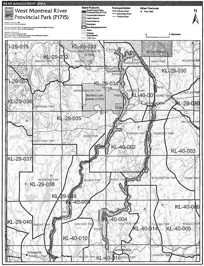
Enlarge Figure 3: Bear Management Areas
Figure 4: Trap Line Areas
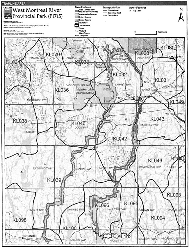
Enlarge Figure 4: Trap Line Areas
5.1.3 Industrial resources
Mineral exploration and mining are not permitted within the park. The mining and surface rights on all lands within the park have been withdrawn from staking under the Mining Act (1990). In accordance with Ontario’s Living Legacy Land Use Strategy, however, access in the park to mining lands (i.e., forest reserve(s) and mining patents) will be permitted for purposes of mineral exploration, development, or operations. Access will be planned in accordance with the requirements of the Environmental Assessment Act. ,
5.1.4 Access and crossings
Access
The park is accessible by road, water and air.
The West Montreal River Provincial Park is accessible from Highway 66, Highway 566 and Highway 560. A canoe route runs through the entire length of the park. And Ontario Federation of Snowmobile Clubs (OFSC) trail crosses the park at two points.
Roads
Highway 66 runs from Highway 11 to Matachewan and provides access to the east side of the park. The Highway crosses the park and forks into Highway 566 and a secondary road. Each of these roads crosses the park. Highway 566 crosses the park along the western arm in the north and the secondary road crosses the park along the western arm at the southern end of Mistinikon Lake. Highway 560 is next to the southern boundary along both the eastern and western arm of the West Montreal River Provincial Park.
Where existing forest access roads are essential for continued.access beyond the park for forest management or recreation purposes, such as land use permits (LUP) and patent land, and alternative road access does not exist, or road relocation is not feasible, existing roads will continue to be available for access. Continued use will include maintenance and may include upgrades (OMNR 2004a). An external source of aggregate, outside the park is required for road improvements and maintenance. Ontario Parks is not responsible for the maintenance or upgrade of any roads within the park boundary.
Any proposed development, maintenance or upgrading of existing roads must meet all Environmental Assessment Act requirements.
Utility corridors
Hydro corridors cross the park in Kimberly, Yarrow and Cairo townships. These corridors are managed by the MNR through a province-wide LUP issued to Hydro One.
The maintenance of the existing utility lines will be permitted. Maintenance activities must adhere to the regulations set out under relevant acts, such as the Environmental Assessment Act, the Canadian Environmental Protection Act (1999), and the Pesticides Act (1990) and shall not negatively impact the values being protected within this park.
All public utilities (e.g., gas pipelines, transmission lines, communications towers) must avoid park lands wherever possible.
New utility corridors may be necessary to maintain essential public services (OMNR 2004a). Any future utility corridors proposed through the park, where park lands are unavoidable, will be reviewed on a case-by-case basis. Protection of park features and values will be priority and all requirements of the Environmental Assessment Act will be met.
Recreational trails
Canoe Route: West Montreal River Provincial Park contains a canoe route. The canoe route has many access points providing canoeists with many travel options. The canoe route also has good campsites and fishing (Wilson, 1988).
Snowmobile Trail: Snowmobile access occurs at Matachewan and again at the southern end of Mistinikon Lake along the same OFSC Trans Ontario Provincial Series (TOPS) connector trail C106A. The Elk Lake Trail Blazers is the local club in the area that maintains this trail.
Snowmobile use on existing routes for access to private land in-holdings, LUPs, and recreational ice fishing may continue unless park values are threatened.
Other Trails: There are currently no other authorized recreational trails within the park boundary. New trails (e.g., hiking) may be developed if the need arises. Any .proposed development within the park is subject to Environmental Assessment Act requirements.
There is an unauthorized trail in Haultain Township that is currently being used by ATV or 4x4 truck to access the river. The superintendent will review the need for this trail.
5.1.5 Adjacent land management
Forestry
West Montreal River Provincial Park is surrounded by the Timiskaming Forest Management Unit 280. This unit is managed according to the 2001-2021 Forest Management Plan for Timiskaming Forest which includes forest harvesting and renewal operations.
Conservation Reserves
There are three conservation reserves (CR) in the immediate vicinity of the West Montreal River Provincial Park.They are Mistinikon Lake Uplands CR, White Fish River Till CR, and the White Fish and East Whitefish Lakes Sandy Till Uplands CR. Other conservation reserves in the area include Dunmore Township Balsam Fir Outwash Deposit CR, Grassy River Halliday Lake Forest & Uplands CR and Makobe Grays Ice Margin CR.
Provincial Parks
Provincial Parks near the West Montreal River Provincial Park include Makobe-Grays River, Englehart River Fine Sand Plain and Waterway, and Grassy River Mond Lake Lowlands and Ferris Lake Uplands.
5.1.6 Land disposition
New land disposition for the private use of individuals or corporations will not be permitted (OMNR 1992; 2000).
Land Use Permits, Licenses of occupation, and unauthorized occupations
There is one Land Use Permit (LUP) within the park for the utility corridor. This LUP is issued to Hydro One.
There are no known licensed occupations within the park. There is one known unauthorized occupation, three unauthorized boat caches and one unauthorized trail/boat launch within the park. The unauthorized occupations are currently being dealt with by enforcement officers. New unauthorized occupations will be dealt with as they are discovered.
Patent land
Private lands are not included in the park and, as such, the. policies and legislation of the Provincial Parks Act do not apply.
Boat caches
There are no known authorized boat caches located within the boundary of West Montreal River Provincial Park. Boats are not permitted to be left unattended in the park without written permission from the superintendent under the authority of the Provincial Parks Act.
5.2 Aquatic ecosystems
Sustaining quality water resources is integral to the protection of park and adjacent land values. The Ministry of Environment (MOE) enforces applicable legislation and regulations for water quality.
5.2.1 Water management
There is one existing water control structure within West Montreal River Provincial Park. The Duncan Lake Dam is owned by MNR but operated by Ontario Power Generation Incorporated (OPGI). It is located in the southwestern section of the park upstream of the point where Wapus Creek drains into the West Montreal River. The dam controls the flow of Duncan Lake and Pigeon Lake into the West Montreal River (OMNR 2003c).
The Mistinikon Lake Dam is outside of the park but influences water levels within the park upstream and downstream from the structure. The dam is owned and operated by OPGI. The dam controls the flow of MistinikonLake into the Montreal River (OMNR 2003c).
New commercial hydroelectric development will not be permitted in the park (OMNR 2000).
5.2.2 Fisheries management
Fisheries management will complement the maintenance and enhancement of native, selfsustaining fish populations. Non-native fish will not be deliberately introduced in the waters contained in this park (OMNR 1992).
Sport fishing
Sport fishing is permitted within the park. This activity is governed by legislation and regulations in the Fish and Wildlife Conservation Act (1997) and the Fisheries Act (1985). The Recreational Fishing Regulations Summary contains details on regulations which are applicable to this area.
Commercial fishing
There are no commercial fishing operations within West Montreal River Provincial Park. New operations will not be permitted (OMNR 2000).
Commercial baitfish harvesting
There are 13 commercial baitfish harvesting licenses (BHAs) allocated by township. The BHAs are in Baden, Powell, Cairo, Yarrow, Kimberly, Doon, Morel, Van Hise, Haultain, Knight, Tyrell, Nicol and Milner townships (Figure 5).
Existing commercial baitfish harvesting may continue where the activity has been licensed or permitted since January 1, 1992. This activity may be subject to conditions identified through future park management planning or fisheries management plans. New baitfish licenses will not be permitted (OMNR 2000; 2003b).
Fish stocking
The stocking of native fish species may be considered through park management planning, with full public and Aboriginal consultation. Non-native fish species will not be deliberately introduced into park waters (OMNR 1992).
Figure 5: Commercial Baitfish Areas
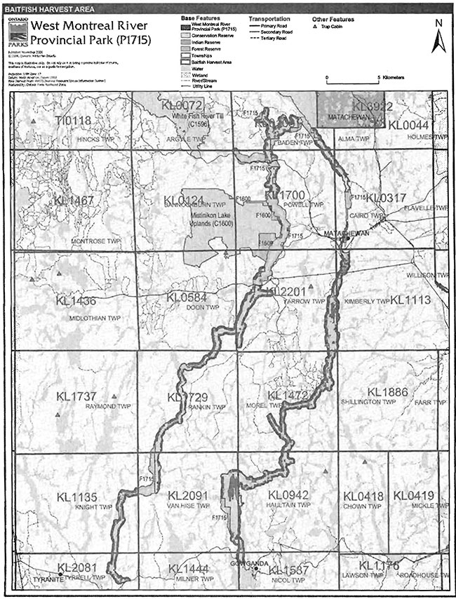
Enlarge Figure 5: Commercial Baitfish Areas
6.0 Operation policies
6.1 Recreation management
Future planning with full public and Aboriginal consultation will review direction on motorized and non-motorized recreation activities.
6.1.1 Motorized recreation
Motorboats
The use of motorboats is permitted to continue, unless park values are threatened (OMNR 2004a).
Aircraft
Aircraft landings are permitted in waterway class parks (OMNR 1992).
Snowmobiles
The authorized Ontario Federation of Snowmobile Clubs (OFSC) Trans Ontario Provincial Series (TOP) connector trail C106A crosses the Montreal River at Matachewan and the West Montreal River south of Mistinikon Lake. These two sections of trail are the only existing authorized sections of snowmobile trail in the park. Existing use will be permitted to continue unless there are significant demonstrated conflicts, in which case the MNR will revaluate the situation and may need to redirect or eliminate use.
Snowmobile use on established routes for access to private land in-holdingst LUP areast and recreational ice fishing may be may be permitted to continue unless such trails threaten park features and values, create user conflicts or raise safety/liability issues.
Proposals for new trails may only be considered through future planning with public and Aboriginal consultation (OMNR 2000).
Off-trail snowmobile use is not permitted.
All-terrain vehicles
There are currently no authorized all-terrain vehicle (ATV) trails within the park. Off-road use of ATVs will not be permitted unless authorized by the superintendent under the authority of the Provincial Parks Act.
Proposals for new trails may only be considered through future planning with public and Aboriginal consultation (OMNR 2000).
6.1.2 Non-motorized recreation
Camping
There are no managed campsites within West Montreal River Provincial Park. There are several unmanaged campsites that are used in conjunction with the canoe route and road access points.
In order to protect the natural and cultural heritage values within the park, it may be necessary to close some areas to camping under the Provincial Parks Act (RSO 1990). A number of existing campsites are in very poor condition as a result of continuous use. Impacts include campsite enlargement, soil compactiont erosion, the accumulation of human waste and garbage, and the cutting of trees, etc. In addition, park users have constructed semi-permanent shelters in some locations, which will be removed.
If there is an identified need, new campsites may be considered (OMNR 2004a), Infrastructure will be permitted in order to protect park features and values in response to use, environmental deterioration and environmental protection requirements. Any proposed development in the park must fulfill the requirements of the Environmental Assessment Act.
Hiking
There are no developed hiking trails within this park.
If there is an identified need, the development of new hiking trails may be considered. Trail infrastructure to protect park values and features will be permitted. Any proposed development within the park is subject to Environmental Assessment Act requirements.
Canoeing/kayaking
Existing uses may continue, unless park values are threatened (OMNR 2004a). Infrastructure to protect park features and values may be permitted and developed in response to use, environmental deterioration, and environmental protection requirements.
6.1.3 Emerging recreational uses
There are emerging recreational uses for which there is limited or no policy to deal with their management (e.g., adventure racing, geocaching). The park superintendent will use legislation, policy and guidelines that are inplace in the interim to manage emerging uses.
6.2 Development
There is no existing park infrastructure. Infrastructure to protect park features and values may be permitted and developed in response to use, environmental deterioration, and environmental protection requirements. Any proposed development within the park is subject to the Environmental Assessment Act.
7.0 Cutural resources
An assessment of the cultural resources specific to West Montreal River Provincial Park has not yet been completed. The management of any cultural values within this park will be directed toward protection and heritage appreciation (OMNR 1992).
8.0 Heritage education
Literature and other supporting information may be developed to describe the park in the context of Ontario’s provincial park system. Boundary limits, significant heritage features and permitted uses of the waterway park may be included in park literature. Prospective park visitors may be informed about the sensitivity and significance of park values through park literature.
9.0 Research
Scientific research by qualified individuals which contributes to the knowledge of natural or cultural history, or to environmental or recreational management, may be encouraged in the park. Ontario Parks will encourage institutions, such as universities, to undertake research projects.
All research programs will require the approval of Ontario Parks and are subject to park policy and other applicable legislation. Any materials removed from the park will remain the property of Ontario Parks.
Approved research activities and facilities will be compatible with the park’s protection objective. Any site which is affected by research will be rehabilitated as closely as possible to its original state. Environmental Assessment Act requirements will apply.
10.0 References
Aikins, M., 2002. Natural Heritage Area Life Science Checksheet West Montreal River (OLL P1715). Ontario Ministry of Natural Resources (OMNR).
Canadian Environmental Protection Act, 1999.
Environmental Assessment Act, 1990.
Fisheries Act, 1985.
Fish and Wildlife Conservation Act, 1997.
Frey, E. and D. Duba., 2002. Earth Science Checksheet- P1715 West Montreal River Provincial Park. OMNR.
Harper, T. 2003. Recreational Report and Checklist for P1715 West Montreal River Provincial Park.
Migratory Birds Convention Act, 1994.
Morris, E. 2003. Natural Heritage Area Life Science Checksheet West Montreal River (OLL P1715). Ontario Ministry of Natural Resources (OMNR).
Mining Act, 1990.
OMNR, 1974. A Topical Organization of Ontario History. Historic Sites Branch Division of Parks.
OMNR, 1992. Ontario Provincial Parks Planning and Management Policies.
OMNR, 1999. Ontario’s Living Legacy Land Use Strategy.
OMNR, 2000. Ontario’s Living Legacy Land Use Strategy (Policy Clarification).
OMNR, 2003a. Public and Aboriginal Consultation Document Form Ontario’s Living Legacy Protected Area Boundary Refinement Review: West Montreal River Provincial Park (P128).
OMNR, 2003b. Directions for Commercial Resource Use Activities in Provincial Parks and Conservation Reserves. 5 pp.
OMNR, 2003c. Montreal River System Water Management Plan Scoping Report.
OMNR, 2004a. Crown Land Use Policy Atlas.
OMNR, 2004b. Forest Fire Management Strategy for Ontario. Aviation and Fire Management Branch.
OMNR, 2005. A Class Environmental Assessment for Provincial Parks and Conservation Reserves.
Pesticides Act, 1990.
Provincial Parks Act, 1990.
Appendix A: Background information
| Name | West Montreal River (P1715) |
|---|---|
| Classification | Waterway |
| Ecoregion/Ecodistrict | 3E-5 (Foleyet) |
| OMNR Administrative Region/District | North East Region - Kirkland Lake |
| Total Area (ha) | 7,259 |
| Regulation date & Number for Park | May 8, 2002 (O. Reg. #147/02) |
Earth science features
The bedrock exposures consist of granite to tonalite, foliated and metamorphosed andesite to basalt flows and tuffs Watabeag supracrustal assemblage, siliceous greywacke of Timiskaming assemblage and Paleoproterozoic Gowganda and Loraine formations (Huronian Supergroup/Cobalt Group), feldspathic to quartzose sandstone, in the central Abitibi Subprovince of the Archean Superior Province (Frey and Duba, 2002).
The exposures include distinctive structures and volcanic, sedimentary and plutonic rock assemblages that formed in the late Archean age, circa 3400 to 2500 million years ago - the beginnings of stabilization of the earth’s crust. Today the rocks of the region display eroded mountain ranges and large intrusive masses, common products of these events (Frey and Duba, 2002).
The Abitibi Subprovince is a Neoarchean, circa 2.8 to 2.6 billion years old, granite-greenstonegneiss terrane. Within this subprovince in Ontario, granite to tonalite batholiths are two of 15 discrete felsic plutonic domains, Watabeag mafic metavolcanic rocks and Timiskaming greywacke are two of more than 60 supracrustal assemblages. As such, their representation in West Montreal River Provincial Park contributes to the conservation of the "Early Archean Basement" and "Late Archean Volcanic Islands and Sedimentary Basins" Precambrian environment themes (Frey and Duba, 2002).
Significance:
Within the Ontario Provincial Park system, the geological features of the West Montreal River Provincial Park have regional significance in representing the Archean felsic metaplutonic and supracrustal (metavolcanic and metasedimentary) and Paleoproterozoic clastic metasedimentary components of the central Abitibi Subprovince in the Archean Superior Province. The surficial geology is locally significant.
Sensitivity:
Although resistant to most human activities, the bedrock exposures of the park are susceptible to graffiti, uncontrolled bedrock sampling and unplanned bedrock disturbances. Appropriate cautionary warnings or controls should be implemented if increased access is promoted.
Life science features- terrestrial
West Montreal River Provincial Park is located in Northeastern Ontario, in the southeastern section of Ecodistrict 3E-5 (Foleyet). The park is located in the glacial Lake Barlow basin just south of the Clay Belt in the Boreal Forest Region. The region has been highly influenced by past glacial processes which have created the region’s existing "look" of a varied physiography marked with large areas of moderately and strongly broken bedrock terrain washed of drift material and with the occasional bedrock knoll. The d posits of glacial Lake Barlow-Ojibway and the clay till ground moraine formed during the readvance of the Cochrane ice sheet to create a landscape that is characterized by glaciofluvial deposits (kame, kettle, outwash and esker) with an irregular hummocky, ridged and keeled topography (Aikins 2002, Morris 2003).
According to Aikins (2002) and Morris (2003), Ecodistrict 3E-5 is characterized by moderately broken plains of granitic and low-base bedrock, generally thinly covered with granitic and lowbase sand and silty sand. The mantle of soil is generally thin with local pockets of deeper silt, clay and sand. An equal representation of soil drainage classes occur within the district. The well drained uplands house podsols and boreal brown podsolics, while peats and peat gleis occur on the poorly drained materials of depressions (Aikins 2002, Morris 2003).
An analysis of digital forest resource inventory (FRI) data was used to obtain quantitative estimates of ecosite representations (Morris 2003). The area supports 14 different ecosite types (Morris 2003), with the dominant ecosite representation being intolerant hardwoods (ES 17). Intolerant hardwoods are interspersed with poor to rich coniferous stands that include red maple (Acer sacharinum), mixed pine uplands, black spruce (Picea mariana), and rock outcrop communities lining the waterway. Many tributaries enter the river system creating numerous tall shrub thickets and open wetlands.
Life science features - aquatic
The region houses several large sized rivers with intensely integrated tributary systems and very large watersheds that flow north into James Bay (Atlantic Watershed), the West Montreal River (West Montreal Tertiary Watershed) being one (Harper 2003). The park is a linear series of lakes along its 110 kilometres: Montreal River- Matachewan, Sisseney, Tommy, Obushkong, Edith and Burk lakes; and, West Montreal River- Mistinikon, Penassi, and Metikemedo lakes (Harper 2003).
The river narrows at several points where notable falls and rapids have been created. The most remarkable of these is now dammed at the Upper Notch Dam, located on the southern leg of the West Montreal River. It is seven metres high and is reported to be one of the longest dams in Ontario. Caribou Falls rumble north of the Upper Notch Dam on the south end of Mistinikon Lake. This series of rapids fall approximately two metres (Harper, 2003). The Matachewan Falls and Dam, also known as High Falls, are located in the northern extent of the lake and park in an area known as the Great Northern Bend, the bending of the West Montreal River south.
Condition - terrestrial component:
There appears to be little recent large-scale natural disturbance within the park. However, past fire history (1940 -1949 & 1990 -1999) has played a role in creating the existing vegetative communities found south of Mistinikon Lake on both rivers (Aikins 2002).
Resource extraction (timber, aggregates, minerals, fur-bearers, fisheries) has resulted in extensive roads associated with area developments- the town of Matachewan, the Matachewan Dam (Baden Township) and Upper Notch Dam (Tyrell Township) and the Obushkong Dam. Evidence of past logging operations remains (plantations and roads) along with traces of the historic Fort Matachewan Hudson’s Bay Trading Post. Other developments include Land Use Permits (LUPs), the crossing of Highway 566 at Matachewan and Mistinikon Bridge, one hydro line, and a bridge just north of Crotch Lake.
Areas adjacent to and within the park under active mining claims have been designated as Forest Reserve until the existing claims or leases retire through normal processes.
Condition - aquatic component:
Major development along the waterway affect aquatic habitats at the town of Matachewan, area.roads, the Matachewan Dam (Baden Township) and Upper Notch Dam (Tyrell Township). Other infrastructure includes the Obushkong Dam.
Fisheries in the park include coldwater fisheries on Matachewan Lake and coolwater fisheries on Sisseney, Obushkong, Burk, Mistinikon, and Penassi Lakes (Aikins 2002).
In October 1990, the river was affected by a 300,000 tonne spill near the town of Matachewan as when a tailings dyke collapsed from an abandoned gold mine. Fine-grained tailings entered the Montreal River from Davidson Creek and settled to cover much of the bottom over a five kilometre stretch of river. The tailings contained high concentrations of several trace heavy metals - PB, Zn, Cd, Cu, Mn, and Ni. A completed bioassay determined that the tailings were lethal to mayfly nymphs and had negative growth effects on chironomid larvae. Study concluded that; the walleye that occur now in the Montreal River where the gold mine tailings spill occurred exhibited slower growth, poorer body condition, and population numbers are smaller than in other parts of the river that were unaffected by the spill.
The rivers in the park provide several hydrological functions and serve as the main artery for the West Montreal Drainage Basin. The northern section of the park acts as a headwater recharge area dominated, by a permeable sandy substrate while the bedrock controlled waterway acts as the main catchment area for the drainage basin. The portions of the boundary that extend beyond the water’s edge and follow several tributaries inland, help protect important riparian habitat and link the terrestrial and aquatic components of the park (Aikins 2002, Morris 2003).
Life science diversity:
Due to the lack of information on the site, it is difficult to discuss the site’s diversity. The area does however, depict the unique ridged and keeled topography of Ecodistrict 3E-5 along with several lowland riparian and wetland communities. This varied terrain supports 14 different ecosite types creating an uneven aged, multispeciated landscape. A more detailed inventory of the area would most likely reveal several additional communities and species of significance. Species richness within the site is strengthened with the inclusion of the typically species rich riparian habitat (Aikins 2002, Morris 2003).
Cultural features
There has been no examination of the cultural resources of the West Montreal River Provincial Park.
Recreation features
The park includes 110 kilometres of the river’s provincially significant canoe route. Avid paddlers provide details on the route and have commented on the condition of campsites, such as those at Split Falls and Tommy Lake, stating that they were highly littered. Despite this, the route is said to be very picturesque and offers good campsites and fishing (Harper 2003).
Being as the waterway is attractive and there are canoe route descriptions, there is good information on recreational paddling (Harper 2003). Some rapids such as the first set heading south along the Montreal River, the Old Woman’s Rapids are rated class 3 in the published Montreal River Canoe route- recreationists need to use available information to determine whether to navigate the rapids given their skill levels or to use portages such as occur in the form of a railway conveyor in the case of the Old Woman’s Rapids (Harper 2003).
There are excellent beaches on Rankin and Sisseney lakes along with several cobble spits along the length of the waterway. (Aikins 2002, Harper 2003, OMNR 1999).
Inventories
| Survey Level | Earth Science | Life Science | Cultural | Recreational |
|---|---|---|---|---|
| Reconnaissance | Frey and Duba, 2002 | Aikins 2002, Morris 2003 |
Harper, 2003 |
Footnotes
- footnote[1] Back to paragraph Transfers include situations where a license is surrendered with a request that it be immediately reissued to another individual or organization that is assuming an existing operation. Trap cabins are considered part of a trapline and would be transferred with the trapline for the purposes of trapping.If a trapline license is revoked or surrendered, all portions of the registered line within the park will be rescinded from the legal description of the trap line (OMNR 2003).