West Sandy Island Provincial Park Management Statement
This document provides policy direction for the protection, development and management of West Sandy Island Provincial Park and its resources.
Approval statement
I am pleased to approve this Interim Management Statement for West Sandy Island Provincial Nature Reserve.
This interim management statement will provide direction for the management of West Sandy Island Provincial Nature Reserve and it provide the basis for ongoing monitoring of activities affecting the park. Should complex issues arise requiring additional studies, more defined management direction, or special protection measures, a more detailed park management plan will be prepared with full public consultation.
The public was widely consulted during the preparation and review of this Statement.
The park will be managed under the jurisdiction of the Superintendent of French River Provincial Park.
Tom Stott
Algoma Zone Manager, Ontario Parks
Background information
- Name: West Sandy Island Provincial Nature Reserve
- Site region/site district: Northern Deciduous Evergreen Forest/SE-5
- OMNR Administrative region/district: Central Region/North Bay District/Nipissing Area
- Total area (ha): 266
- Regulation date: December 1994
Targets
Earth science representation
No research as of this date; no known earth science significance
Life science representation
- Upland Forest
- normal/rock/dry: coniferous forest- white pine (Pinus strobus)/red pine (Pinus resinosa)/rock
- normal/sand/dry: mixed forest - red pine/aspen (Populus tremuloides)/white birch (Betula papyrifera)
- warmer/sand/dry: coniferous forest - red pine
- normal/sand/dry: mixed forest - red maple (Acer rubrum)/red pine/white pine/red oak (Quercus rubrs)/aspen
- normal/sand/dry: mixed forest - aspen/red pine/red maple
- Wetland
- normal/loam/wet: lowland deciduous swamp - silver maple (Acer saccharinum)/red maple/green ash (Fraxinus pannsylvanica)
- normal/loam/very wet: lowland swamp - mountain-holly (Nemopanthus mucronatus)/green ash
- normal/organic/very wet: lowland meadow (fen) - leatherleaf (Chamaedaphne)/sweet gale (Myrica gale L.)
- normal/loam/very wet to open water: lowland marsh - cat-tail (Typha latifolia)/willow (Salix)/meadowsweet (Spirsea alba var. latifolia)
- normal/loam/saturated to open water: lowland deciduous (marsh) - red maple/canada blue-joint (Calamagrostis canadensis)
- Upland Open Banen
- warmer/rock/dry: upland rock - lichen/rock
- Upland Beach
- warmer/sand/dry: beach - sand/scattered trees/shrubs
Cultural resources representation
No research as of this date: no documented cultural heritage values, but has moderate to high archaeological potential given its location
Recreation opportunities
No specific studies; but generally will accommodate: wildlife viewing; walking; and snowshoeing
| Survey level | Earth science | Life science | Cultural | Recreational | Other |
|---|---|---|---|---|---|
| Reconnaissance | needed | checklist 1991 site region report |
needed | needed | [no information provided] |
| Detailed | needed | needed | [no information provided] | [no information provided] | [no information provided] |
| Requirement | theme study | site district report | [no information provided] | [no information provided] | [no information provided] |
Values to be protected
West Sandy Island Provincial Nature Reserve is located at the entrance to the French River in site district SE-5. Sandy Island is an east-west trending island just north of Lake Nipissing’s south shore in Bertram Township. The park totals 266 hectares of land on the west side of Sandy Island (Figure 1). An additional 233 hectares is patented land on the eastern portion of the island.
The Island is characterized by a relatively flat plain of sand and gravel which almost completely covers the bedrock. The sand and gravel deposits were originally deposited in glacial rivers. They were subsequently modified by wave action during their submergence in high lake levels of lake Nipissing following the retreat of the Ice Age glaciers over 10,000 years ago. Through a combination of lowering lake levels and continued rising of the basin because of postglacial rebound, the Island emerged from beneath the waters of Lake Nipissing only a few thousand years ago. Accumulation of organic deposits has occurred in shallow depressions since that time.
The upland forests range from near pure stands of red pine to mixed stands of aspen, white pine, and white birch. An old red pine stand near the eastern boundary is the best example of red pine in the site district and is, therefore, considered to be provincially significant. The presence of relic shoreline flora; tall cord grass (Spartina pectinata) is regionally and perhaps provincially significant. The park also has remnant deposits of the upper beaches of glacial lake Algonquin. Another regionally significant species found in an openwater bullrush and sweet gale marsh include Farwell’s milfoil (Myriophyllum farwellif)
The area is also important for its extensive wetlands. Silver maple and green ash swamps account for approximately 25 percent of the park. Many of the larger maple trees are in excess of 130 years. Additionally, significant features include open water marshes and fens.
The intent of this statement is to protect these values by establishing management guidelines for existing and permitted uses in the park.
Management guidelines
Land tenure
West Sandy Island Provincial Nature Reserve consists entirely of Crown land. Private land abuts the park along its entire eastern boundary and parts of its southern boundary. The boundary between Crown and private land to the east has been surveyed, cut and posted with no trespassing signs. A tourist lodge and eight individual private cottage lots occur along the southern boundary of the park. The eastern half of the island shore contains several cottages and one tourist lodge. Currently, these surrounding private land uses are compatible with the objectives of West Sandy Island Provincial Nature Reserve. Planning authorities are encouraged to ensure natural heritage values within the park are considered and protected in planning decisions on private land.
Ontario Parks and the MNR will work with private landowners to mark the southern park boundary in a manner that is effective, cost efficient, and acceptable to all parties. In most cases, this will consist of a compass line survey and posting no trespassing symbols.
Any unauthorized occupations of lands within the park will be managed following approved policy. Unauthorized structures will be removed at the owner’s expense.
Existing/proposed development
There are no existing structural facilities in the park. A number of trails and an east-west bush road provide internal access (Figure 1). These pre-date the park.
The bush road will be allowed to continue as a non-conforming use. Ontario Parks will not maintain it. This bush road will not be altered without prior approval from the French River Provincial Park Superintendent. New development (e.g. campsites, trails, roads, boat docks, privies and commercial facilities) is not permitted.
Existing unplanned camping sites will be posted for day-use only, no camping, and no campfires.
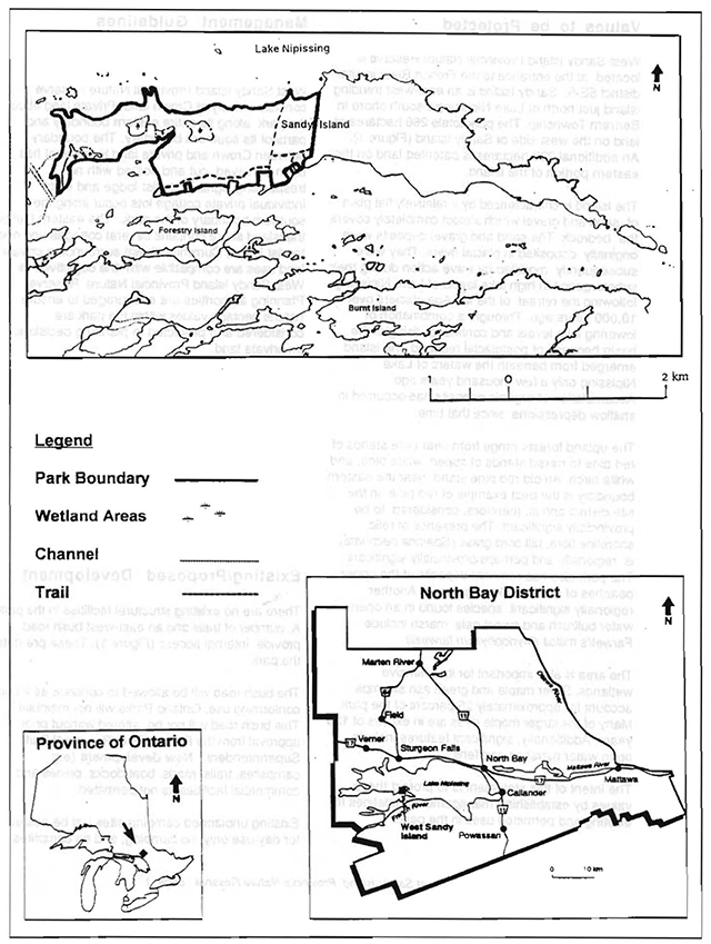
Enlarge Figure 1: West Sandy Island Provincial Nature Reserve
Recreational activities
Recreational uses such as walking, wildlife viewing, and photography are not currently managed and will continue. Sport hunting and trapping are not permitted within the park. Off-shore waterfowl hunting is a popular activity and is not affected by this restriction. Sport fishing is permitted within nature reserve class parks: however, opportunities are limited due to a lack of watercourses and lakes within the boundaries of West Sandy Island Provincial Nature Reserve.
Mechanized travel is permitted as a nonconforming use on the existing east-west bush road within the park for fire protection purposes and for access to cottages. Mechanized travel will not be permitted in the rest of the park. Other “trails” will be allowed to naturally revegetate.
Camping and campfires are not permitted within West Sandy Island Provincial Nature Reserve.
Commercial activities
Commercial uses are not permitted (e.g., trapping, bait fishing, mineral resources exploration/development, forestry, etc.). The park will not be part of the bear management area of the local commercial outfitter. The park will be excluded from the registered trapline should management by non-status Natives be proposed.
Indigenous interests
At the time of publication, there were no land claims concerning park management. West Sandy Island, however, lies within the Nipissing and Dokis First Nations’ areas of interest. Treaty and Aboriginal rights will continue to be respected. There is currently one trapline running through the park which is managed by a Native. Should management be transferred by the current trapper to a non-status Indian, the trapline will be removed from the park at the time of transfer.
Natural resource stewardship
a. Vegetation management
Given the small area on the Island and private interests, forest fires will be suppressed in accordance with the fire operations plan for the East Fire Region. Fire suppression will consist of fire management activities which are compatible, to the greatest extent possible, with the parks’ protection objective. A fire management partnership may be established with adjacent landowners to help deal with fire issues. This may include inventorying existing equipment held in private ownership. A fire management plan will be developed to outline priorities in: fire response; fire reporting procedures; emergency evacuation; and fire prevention.
Programs may be developed to control forest insects and diseases in the park where these threaten significant heritage or aesthetic values or where they are non-native to the area. Where control is desirable, it will be directed as narrowly as possible to the specific insect or disease. Biological control will be used wherever possible.
Commercial forestry operations are not permitted.
b. Fish and wildlife management
Fisheries and wildlife will continue to be managed using existing policies and regulations for the area.
Cultural resources stewardship
Ontario Parks will work with other government agencies to identify archaeological sites which should be protected. Field surveys are required to more adequately manage and protect sites. To date, there has been no assessment of cultural resources. The potential for cultural resources is high given the Island location. Historically, the Island was a natural stopover for Native peoples, early explorers, and voyageurs who used the French River and surrounding travel routes.
Heritage education
Heritage education will address inquiries by providing information concerning access, heritage appreciation, and park boundaries. Information that is given out will convey the message that visitors have a responsibility to help protect the park and to respect the rights of private property owners adjacent to the park. A “leave-no-trace” attitude will be encouraged to minimize human impact park environments and wildlife.
Research
Scientific research by qualified individuals, contributing to the knowledge of natural and cultural history as well as environmental and recreational management will be encouraged.
Additional earth and life science and cultural surveys are required to refine information on values and management. These are considered to be a priority. Research related to the study of natural processes will also be encouraged provided it does not harm park values.
All research programs will require the prior approval of Ontario Parks and will be subject to Ontario Parks’ policies and other relevant legislation (Appendix A). Ontario Parks may approve the removal of any natural or cultural specimen by qualified researchers. All such materials removed remains the property of Ontario Parks.
Approved research activities and facilities must be compatible with the protection objective. Permanent plots or observation stations may be established as part of the approvalof research. This will only be possible where the intent of the research is to revisit a specific location over time. Any site that is to be disturbed will require assessment of its original nature. This will be used to return the site as closely as possible to its original state once the research is complete.
Marketing
Marketing efforts to increase use of the park are not a priority. Signs depicting “no camping” and “no campfire” symbols will be limited to key areas such as past unplanned campsites or entry points. “No trespassing” signs are currently posted along the eastern boundary line between park and private land. Signs depicting “no snowmachine travel” may be considered in the future. Fact sheets or brochures for West Sandy Island Provincial Nature Reserve will not be produced or made public; however, copies of this statement will be made available upon request for additional information. District MNR and Ontario Parks staff will provide information about other operating parks in the area. They will carry information on the services of commercial establishments in the area which can be used as bases from which to visit the park.
Implementation
Implementation of this IMS will primarily involve monitoring activities to ensure adherence to the management guidelines. Other activities will include: marking park boundaries, placing “no camping” and “no campfire” signs at unplanned campsites and potential entry points, and responding to inquiries about the park. A fire management plan will be prepared by 1997. This plan will outline priorities in prevention, reporting, response and evacuation.
Implementation of this IMS and management of the park are the responsibility of the French River Provincial Park Superintendent. West Sandy Island, however, is a separate park from French River Provincial Park.
Review and revision
This IMS will be reviewed on an ongoing basis.
If, at any time, changes in management direction are needed the significance of the changes will be evaluated. Minor changes which do not alter the overall protection objective may be considered and approved by the Superintendent of French River Provincial Park without further public consultation. The interim management statement will be amended accordingly. In assessing major changes, a more detailed park management plan will be considered. Where a management plan is not considered necessary or feasible, a major amendment may be undertaken with public consultation. Major amendments will be approved by the Ontario Parks, Algoma Zone Manager.
References
The following list of references contains all material cited in this document, as well as other relevant sources of information on the park.
Department of Energy, Mines and Resources. 1969. Nipissing: Topographic Map Series, 1:50 000 Sheet 31 L/4.
Kershaw, W. 1993. West Sandy Island Life Science Inventory Field Notes.
Noble, T.W., 1991. Assessment of Natural Areas and Features. Northern Portion of the Northern Deciduous Evergreen Forest Site Region SE.
Ontario Ministry of Natural Resources, 1995. East Fire Region- Fire Operations Plan.
Ontario Ministry of Natural Resources, 1980. Forest Resource Inventory Map- Bertram Township.
Ontario Ministry of Natural Resources, 1983. North Bay District Land Use Guidelines.
Ontario Ministry of Natural Resources, 1989. Provincial Parks Policy Implementation Details.
Ontario Ministry of Natural Resources, 1994. West Sandy Island Keep it Wild Campaign Candidate Area Report.
Provincial Parks and Natural Heritage Policy Branch, 1992. Ontario Provincial Parks Planning and Management Policies (1992 update).
Ontario Parks, 1996. Strategic Direction Statement. March 18, 1996.
Appendix A
Ministry of Natural Resources and Forestry application to conduct research in Ontario provincial parks
[A new version of this form can be found on the Ontario Parks website.]