West Wabigoon River Conservation Reserve Management Statement
This document provides policy direction for the protection, development and management of the West Wabigoon River Conservation Reserve and its resources.
Statement of Conservation Interest (C2338)
March 2001
Dryden District
Ministry of Natural Resources
Approval statement
We are pleased to approve this Statement of Conservation Interest for West Wabigoon River Conservation Reserve (C2338).
This Statement of Conservation Interest will provide guidance for the management of the Conservation Reserve and form the basis for ongoing monitoring of activities.More detailed direction is not anticipated at this time.Should significant facility development be considered or complex issues arise requiring additional studies, more defined management direction, or special protection measures, a more detailed Conservation Reserve Management Plan will be prepared with full public consultation.
West Wabigoon River Conservation Reserve will be managed under the jurisdiction of the Wabigoon Area supervisor, Dryden District, Ministry of Natural Resources.
for;
Signed by:
Charlie Lauer
Regional Director
Northwest Region
Ministry of Natural Resources
Date: May 1, 2001
Signed by:
R.G. McColm
Dryden District Manager
Ministry of Natural Resources
Date: April 29, 2001
1.0 Background information
| Name | West Wabigoon River Conservation Reserve |
|---|---|
| Site Region / Site District | Lake Wabigoon / 4S-4 |
| OMNR Administrative Region/District/Area | Northwestern Region / Dryden District / Wabigoon Area |
| Total Area (ha) | 713 |
| Regulation Date | Anticipated in 2001 |
1.1 Targets
| Earth Science Representation | Well formed levees Very weakly broken lacusterine clay plain |
|
|---|---|---|
| Life Science Representation | 1. Wetlands |
|
| Life Science Representation | 2. Upland Forest |
|
| Cultural Resources Representation | None currently identified | |
| Recreation Opportunities | No specific studies, but generally will accommodate: wildlife viewing, fishing, hiking, hunting, snowshoeing, cross-country skiing, snowmobiling and ATV use where values are protected. |
1.2 Inventories
| Survey Level | Earth Science | Life Science | Cultural | Recreational | Other |
|---|---|---|---|---|---|
| Reconnaissance Survey | Biophysical evaluation 1989; gap analysis 1995. Survey completed October 2000 |
Gap analysis completed 1995. Survey completed October 2000. |
Required | Required | |
| Detailed | Not required | Not required | Not required | Not required |
2.0 Values to be protected
West Wabigoon River Conservation Reserve is located in site district 4S-4, approximately 40 kilometers northwest of the City of Dryden.The site is situated in Colenso Township adjacent to Wildrice and Cowmula Lakes and completely encompasses both Final Lake as well as a four kilometer reach of Wabigoon River.
This site is part of a significant "large river riparian" complex containing several representative features including lacusterine deposits, alluvium and organic-filled valleys as well as well-formed levees which separate peat-filled basins from the main river channel. The mineral substrate that is found at this site is the only known example of "very weakly broken" deposits in site region 4S-4, as classified by the Ontario Land Inventory. Small backwater basin lakes, susceptible to periodic flooding, have also formed where the Wabigoon River has cut through its levees.
The wetland complex found within the site boundaries is considered locally significant as it contains the largest eastern larch swamp in Dryden District. Also present are small areas of treed fen containing regionally rare plant species including dwarf birc-Betula pumila, as well as locally significant levee- associated stands of black ash (Fraxinus nigra). The stands of black ash provide valuable, unique representation of regionally non-typical tree species associated with well-developed, naturally occurring river levees.The riparian areas of the Wabigoon River have remained relatively undisturbed from human activities and consequently provide a unique example of naturally occurring, large-river associated levees.
Stands of white spruce and balsam fir located west of Final Lake provide moose and white-tailed deer with good late winter habitat, as well as a variety of forest birds with potential nesting sites. In addition to providing aquatic feeding areas for moose, seasonally flooded riparian zones adjacent to the Wabigoon River may serve as spawning and/or rearing grounds for a variety fish species, nesting areas for waterfowl and spawning habitat for amphibians.
A portion of the site located southwest of Final Lake has been altered through commercial forest harvest operations which occurred in the late 1970's. Commercially harvested areas have been regenerated. A limited number of trees have also been removed in the past under the authority of personal use permits for fuelwood purposes.
The intent of this Statement is to protect these values by establishing management guidelines for existing and potential uses in the conservation reserves.
3.0 Management guidelines
3.1 Land tenure
West Wabigoon River Conservation Reserve consists entirely of Crown land. A small tract of private land is located adjacent to the southern boundary of the conservationreserve, between Cowamula Lake and Wabigoon River. Currently there are no existing private recreation camps located within the conservation reserve.
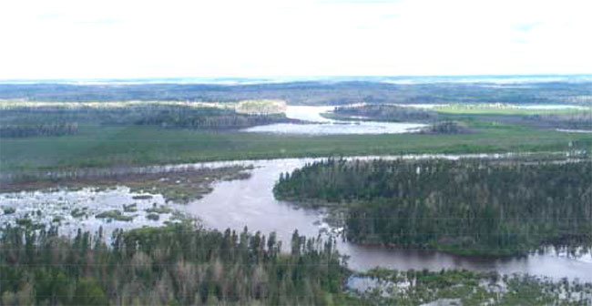
Figure 1. View of Colenso Creek / Wabigoon River confluence (looking north)
The limited development of land surrounding this site is compatible with the intended management direction for conservation reserves in Ontario. Applications for more intense use will be reviewed to ensure natural heritage values within the conservation reserve are considered and protected in resource management planning decisions. The ministry will work with private landowners to delineate the boundary between Crown and private land in a manner that is effective, cost efficient and acceptable to both parties. In most cases, this will consist of a compass line survey with no trespassing symbols painted in strategic locations.
Any unauthorized occupations of lands within the conservation reserve will be managed in accordance with approved policy, and will be removed at the owner’s expense.
New transmission lines, pipelines, highways and road corridors will be discouraged. Expansion of roads or utility line right-of-way may be permitted to meet essential public service needs. Before disposing of conservation lands for these purposes, the Ministry of Natural Resources will work closely with proponents to ensure that:
- all reasonable alternatives have been considered
- impacts on heritage values are minimized
Industrial uses such as hydroelectric development, extraction of aggregates, peat, soils and other similar materials will not be permitted.
Careful mineral exploration may occur in areas that have provincially significant mineral potential. If a portion of the conservation reserve is to be developed for a mine, it would be removed from the reserve, and appropriate replacement lands would be placed into regulation.
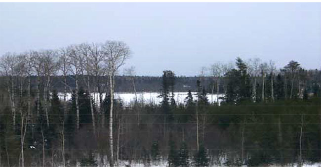
Figure 2. View of Cowamula Lake February (view looking north east)
3.2 Existing/ proposed development
Currently there are no existing facilities in the conservation reserve. A number of decommissioned forest extraction roads that have been abandoned exist in the northeastern segment of the site. These roads pre-date the conservation reserve and consequently will not actively be maintained.
Provincial policies regarding activities permitted in conservation reserves are defined under Ontario’s Living Legacy- Land Use Strategy. Under this strategy new development such as campsites, parking lots, and privies will not be considered until more detailed earth science and cultural information is collected and a more detailed management plan is prepared. New tourism developments will not be permitted.
3.3 Recreation activities
Recreation uses such as walking, hiking, wildlife viewing, camping, fishing, snowshoeing and cross-country skiing are currently not specifically managed and will be allowed to continue. Sport hunting will continue as a regulated use.
Snowmobiles and All Terrain Vehicles are permitted on existing trails and forest access roads within the Conservation Reserve. Currently under the existing Land Use Strategy , all mechanized travel is restricted to existing trails. Off trail vehicle use is permitted for the retrieval of game only.
The construction of new trail networks for snowmobiling / ATV use, cycling, horseback riding, hiking and cross-county skiing maybe considered, but will require more detailed planning.
3.4 Commercial activities
Currently commercial uses are limited to fur harvesting, commercial bear hunting and commercial bait fishing.
All existing commercial bait fishing and commercial bear hunting (within bear management areas) operations are permitted to continue, as outlined within the Land Use Strategy.
New commercial bait fishing operations may be considered on a case by case basis. No new commercial bear hunting operations are permitted (transfer of existing licenses may be considered).
Existing commercial fur harvesting operations are permitted to continue unless there are significant demonstrated conflicts. New operations may be considered, subject to a "test of compatibility".
3.5 Aboriginal interests
West Wabigoon River Conservation Reserve (C2338) lies within Treaty 3 area. Currently there are no identified First Nation’s land claims or traditional use areas identified within this Conservation Reserve. All identified aboriginal and treaty rights will continue to be respected.
3.6 Natural Resource Stewardship
3.6.1 Vegetation management
West Wabigoon River Conservation Reserve (C2338) will be managed by allowing natural ecosystems, processes and features to operate normally, with minimal human interference. This approach will ensure the provision of adequate buffer habitat for the protection of the integrity of centrally located tamarack and black ash swamps, as well as associated wetland complexes.
Forest fire protection will be carried out as on surrounding public lands. If necessary, alternative direction for the control of fire or the use of fire for management purposes may be approved through a more detailed local natural resource or management plan.
Programs may be developed to control forest insects and diseases within the conservation reserve if it is deemed that significant heritage, esthetic or economic values are threatened.
Where control is desirable, it will be directed as narrowly as possible to the specific insect or disease. Biological control will be promoted whenever possible.
In the future, and if necessary, vegetation control may be permitted for new public utilities and rights-of-way.
3.6.2 Fisheries and wildlife management
Fishery and Wildlife resources will continue to be managed in accordance with specific policies and regulations defined by the Ontario Ministry of Natural Resources.
Fishing and hunting opportunities will be encouraged within the area, as well as wildlife viewing activities during the non-hunting season.
3.6.3 Landforms
The Wabigoon River Levees, representative of a large river riparian system, will not be altered through land form modification activities such as filling or extraction.Mining and the extraction of aggregates or similar materials are currently not permitted.
3.6.4 Water quality
Periodic flooding of the Wabigoon River may result in potential, deleterious impacts on peripheral riparian areas as a result of nutrient loading or heavy metal deposition. Elevated heavymetal loading as well as nutrient deposition within the Wabigoon Rivercan primarily be attributed to extensive agricultural activity on adjacent clay lands and subsequent precipitation runoff over these areas. Potential water quality concerns may also be linked to industrial effluent discharge from upstream sources.
If it is deemed necessary, monitoring of ecologically sensitive flooded areas may be considered through further, more detailed management planning.
3.7 Cultural resources stewardship
When possible, the Ontario Ministry of Natural Resources will continue to work with the Ontario Ministry of Culture,Tourism and Recreation in identifying archaeological sites to be protected. To more fully manage and protect sites, the development of field surveys will be required. To-date, a detailed assessment of cultural resources has not been carried out.
3.8 Client services
Currently visitor services are limited to responding to inquiries about basic levels of information such as access, natural heritage appreciation and boundaries.
3.9 Research
Scientific research by qualified individuals, which contributes to the knowledge of natural and cultural history and to environmental or recreational management will be encouraged.
Extensive earth and life science inventories have been carried for this site. Additional cultural or recreational surveys may be necessary to refine the values outlined in management guidelines.
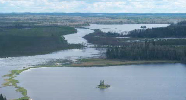
Figure 3. View of Cowamula Lake looking along Colenso Creek
Research related to the study of natural processes will also be encouraged provided it does not negatively impact upon the values of the reserve.
All research programs will require the approval of the Ministry of Natural Resources and will be subject to ministry policies and legislation.
Permanent plots or observation stations may be established to which researchers may return over time.Prior to the excavation or removal of any significant historical artifacts, consultation with the Ministry of Citizenship and Culture will take place.
Approved research activities and facilities must remain compatible with the protection objective.Permanent plots or observation stations may be established to which researchers can return over time.
Any site that is disturbed as a result of research activities will be rehabilitated as closely as possible to its original state.
3.10 Marketing
West Wabigoon River Conservation reserve will be marketed as a unique example of a significant larch swamp and riverine riparian system.In this regard, fact sheets may be prepared to inform and educate visitors about these values.Marketing efforts to increase current use are not considered a priority.
4.0 Implementation
Implementation of this Statement of Conservation Interest will primarily involve monitoring activities to ensure the adherence to the management guidelines. Other activities may include delineating the Conservation Reserve Boundaries, preparing additional fact sheets highlighting the unique natural values found within the area and responding to inquiries about the site.
Implementation of this Statement of Conservation Interest and subsequent management of the reserve are the responsibility of the Wabigoon area supervisor.Partnerships may be explored to address specific management needs.
5.0 Review and revisions
West Wabigoon River Conservation Reserve Statement of Conservation Interest will be reviewed on a continual basis.
If adjustments to management direction are required at any time, the significance of the changes will be evaluated prior to implementation. Minor changes that do not alter the overall protection objectives may be considered and approved by the area supervisor without additional public consultation.
In assessing major changes, the need for a more detailed Conservation Management Plan will first be considered. Where a management plan is not considered feasible or necessary, a major amendment may be considered utilizing public consultation. Any major amendments to the Statement of Conservation Interest must be approved by the District Manager and the Regional Director.
6.0 Sources of information
North – South Environmental Inc. 2000.Earth Science and Life Science Reconnaissance Survey – West Wabigoon Conservation Reserve.
Noble, T.W.1995. Site District 4S4, Gap Analysis.
Ontario Ministry of Natural Resources.1997. Conservation Reserves Policy – PL 3.03.5.
Map 1: Site reference map
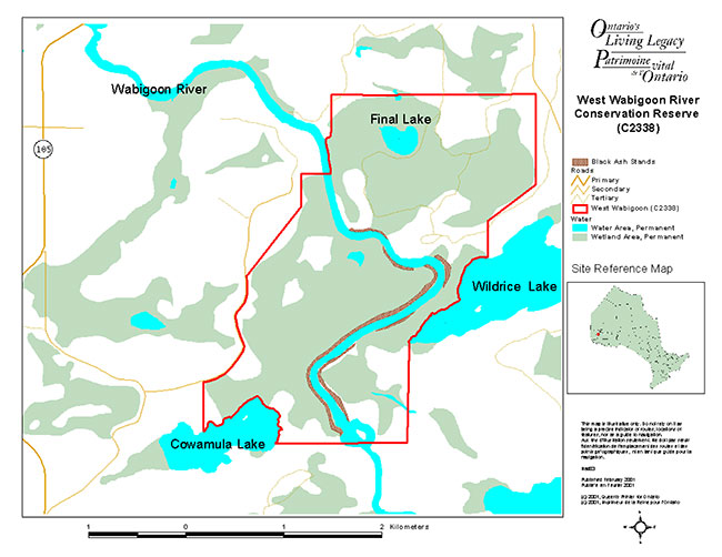
Enlarge Map 1: Site reference map
Map 2: Site reference map - Northwestern Ontario
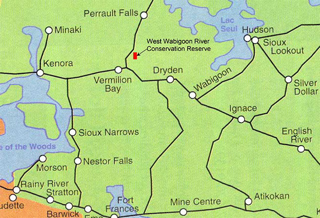
Enlarge Map 2: Site reference map - Northwestern Ontario
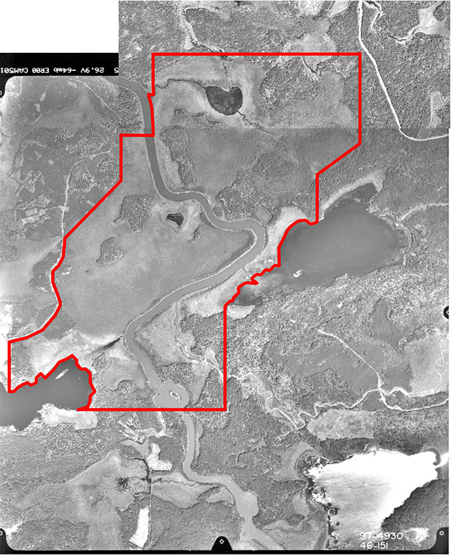
Figure 4: West Wabigoon River Conservation Reserve – C2338, aerial photo image