Western Silvery Aster recovery strategy
Read the recovery strategy for the Western Silvery Aster, a plant species at risk in Ontario.
About the Ontario recovery strategy series
This series presents the collection of recovery strategies that are prepared or adopted as advice to the Province of Ontario on the recommended approach to recover species at risk. The Province ensures the preparation of recovery strategies to meet its commitments to recover species at risk under the Endangered Species Act, 2007 (ESA) and the Accord for the Protection of Species at Risk in Canada.
What is recovery?
Recovery of species at risk is the process by which the decline of an endangered, threatened, or extirpated species is arrested or reversed, and threats are removed or reduced to improve the likelihood of a species’ persistence in the wild.
What is a recovery strategy?
Under the ESA a recovery strategy provides the best available scientific knowledge on what is required to achieve recovery of a species. A recovery strategy outlines the habitat needs and the threats to the survival and recovery of the species. It also makes recommendations on the objectives for protection and recovery, the approaches to achieve those objectives, and the area that should be considered in the development of a habitat regulation. Sections 11 to 15 of the ESA outline the required content and timelines for developing recovery strategies published in this series.
Recovery strategies are required to be prepared for endangered and threatened species within one or two years respectively of the species being added to the Species at Risk in Ontario list. Recovery strategies are required to be prepared for extirpated species only if reintroduction is considered feasible.
What’s next?
Nine months after the completion of a recovery strategy a government response statement will be published which summarizes the actions that the Government of Ontario intends to take in response to the strategy. The implementation of recovery strategies depends on the continued cooperation and actions of government agencies, individuals, communities, land users, and conservationists.
For more information
To learn more about species at risk recovery in Ontario, please visit the Ministry of the Environment, Conservation and Parks Species at Risk webpage.
Recommended citation
Ministry of the Environment, Conservation and Parks. 2018. Recovery Strategy for the Western Silvery Aster (Symphyotrichum sericeum) in Ontario. Ontario Recovery Strategy Series. Prepared by the Ministry of the Environment, Conservation and Parks, Peterborough, Ontario. iv + 5 pp. + Appendix. Adoption of the Recovery Strategy for the Western Silvery Aster (Symphyotrichum sericeum) in Canada (Environment Canada 2017).
© Queen’s Printer for Ontario, 2018
ISBN 978-1-4868-2768-8 (HTML)
ISBN 978-1-4868-2769-5 (PDF)
Content (excluding the cover illustration) may be used without permission with appropriate credit to the source, except where use of an image or other item is prohibited in the content use statement of the adopted federal recovery strategy.
Cette publication hautement spécialisée « Recovery strategies prepared under the Endangered Species Act, 2007 », n’est disponible qu’en anglais en vertu du Règlement 411/97 qui en exempte l’application de la Loi sur les services en français. Pour obtenir de l’aide en français, veuillez communiquer avec recovery.planning@ontario.ca.
Declaration
The recovery strategy for the Western Silvery Aster was developed in accordance with the requirements of the Endangered Species Act, 2007 (ESA). This recovery strategy has been prepared as advice to the Government of Ontario, other responsible jurisdictions and the many different constituencies that may be involved in recovering the species.
The recovery strategy does not necessarily represent the views of all of the individuals who provided advice or contributed to its preparation, or the official positions of the organizations with which the individuals are associated.
The recommended goals, objectives and recovery approaches identified in the strategy are based on the best available knowledge and are subject to revision as new information becomes available. Implementation of this strategy is subject to appropriations, priorities and budgetary constraints of the participating jurisdictions and organizations.
Success in the recovery of this species depends on the commitment and cooperation of many different constituencies that will be involved in implementing the directions set out in this strategy.
Responsible jurisdictions
Ministry of the Environment, Conservation and Parks
Environment and Climate Change Canada
Canadian Wildlife Service, Ontario
Parks Canada Agency
Executive summary
The Endangered Species Act, 2007 (ESA) requires the Minister of the Environment, Conservation and Parks to ensure recovery strategies are prepared for all species listed as endangered or threatened on the Species at Risk in Ontario (SARO) List. Under the ESA, a recovery strategy may incorporate all or part of an existing plan that relates to the species.
The Western Silvery Aster (Symphyotrichum sericeum) is listed as endangered on the SARO List. The species is also listed as threatened under the federal Species at Risk Act (SARA). Environment and Climate Change Canada prepared the Recovery Strategy for the Western Silvery Aster (Symphyotrichum sericeum) in Canada in 2017 to meet its requirements under the SARA. This recovery strategy is hereby adopted under the ESA. With the additions indicated below, the enclosed strategy meets all of the content requirements outlined in the ESA.
The Critical Habitat section of the federal recovery strategy provides an identification of critical habitat (as defined under the SARA). Identification of critical habitat is not a component of a recovery strategy prepared under the ESA. Under the ESA, a habitat regulation has been in force for Western Silvery Aster since 2009. However, a previously unknown occurrence was documented in 2014 and is not covered by the regulation. It is recommended that the approach used to identify critical habitat in the federal recovery strategy, along with any new scientific information pertaining to the Western Silvery Aster and the areas it occupies, be considered when reviewing the habitat regulation under the ESA.
Adoption of federal recovery strategy
The Endangered Species Act, 2007 (ESA) requires the Minister of Natural Resources and Forestry to ensure recovery strategies are prepared for all species listed as endangered or threatened on the Species at Risk in Ontario (SARO) List. Under the ESA, a recovery strategy may incorporate all or part of an existing plan that relates to the species.
The Western Silvery Aster (Symphyotrichum sericeum) is listed as endangered on the SARO List. The species is also listed as threatened under the federal Species at Risk Act (SARA). Environment and Climate Change Canada prepared the Recovery Strategy for the Western Silvery Aster (Symphyotrichum sericeum) in Canada in 2017 to meet its requirements under the SARA. The portions of this recovery strategy relevant to the Ontario distribution is hereby adopted under the ESA. With the additions indicated below, the enclosed strategy meets all of the content requirements outlined in the ESA.
Species assessment and classification
| Assessment | Status |
|---|---|
| SARO list classification | Endangered |
| SARO list history | Endangered (2000), Endangered (1996) |
| COSEWIC assessment history | Threatened (2000), Vulnerable (1988) |
| SARA schedule 1 | Threatened |
| Conservation status rankings |
|
Distribution, abundance and population trends
A brief update is provided concerning the French Portage Narrows population in Ontario. It was last observed in 2017 at which time approximately 50 patches were enumerated with five to 13 stems per patch giving a total of 250 to 600 stems (S. Brinker, pers. comm. 2018).
Area for consideration in developing a habitat regulation
Under the ESA, a recovery strategy must include a recommendation to the Minister of Natural Resources and Forestry on the area that should be considered in developing a habitat regulation. A habitat regulation is a legal instrument that prescribes an area that will be protected as the habitat of the species. Under the ESA, a habitat regulation has been in force for Western Silvery Aster since 2009. The recommendation provided below will be one of many sources considered by the Minister, including information that may become newly available following completion of the recovery strategy, when reviewing the habitat regulation for this species.
The Critical Habitat section of the federal recovery strategy provides an identification of critical habitat (as defined under the SARA). Identification of critical habitat is not a component of a recovery strategy prepared under the ESA. However, it is recommended that the approach used to identify critical habitat in the federal recovery strategy for the Ontario region, along with any scientific information pertaining to Western Silver Aster and the areas it occupies be considered when reviewing the habitat regulation under the ESA. Although a habitat regulation under the ESA has been developed for the species, a previously unknown occurrence was documented in 2014 and is not covered by the existing habitat regulation under the ESA.
Glossary
- Committee on the Status of Endangered Wildlife in Canada (COSEWIC)
- The committee established under section 14 of the Species at Risk Act that is responsible for assessing and classifying species at risk in Canada.
- Committee on the Status of Species at Risk in Ontario (COSSARO)
- The committee established under section 3 of the Endangered Species Act, 2007 that is responsible for assessing and classifying species at risk in Ontario.
- Conservation status rank
- A rank assigned to a species or ecological community that conveys its degree of rarity at the global (G), national (N) or subnational (S) level. These ranks, termed G-rank, N-rank and S-rank, are not legal designations. Global and National ranks are determined by NatureServe. Subnational S-ranks are determined for Ontario by the Natural Heritage Information Centre. The conservation status of a species or ecosystem is ranked from 1 to 5, preceded by the letter G, N or S which shows the geographic scale of the assessment. The numbers mean the following:
- 1 = critically imperilled
- 2 = imperilled
- 3 = vulnerable
- 4 = apparently secure
- 5 = secure
- NR = not yet ranked
- Endangered Species Act, 2007 (ESA)
- The provincial legislation that provides protection to species at risk in Ontario.
- Species at Risk Act (SARA)
- The federal legislation that provides protection to species at risk in Canada. This act establishes Schedule 1 as the legal list of wildlife species at risk. Schedules 2 and 3 contain lists of species that at the time the Act came into force needed to be reassessed. After species on Schedule 2 and 3 are reassessed and found to be at risk, they undergo the SARA listing process to be included in Schedule 1.
- Species at Risk in Ontario (SARO) List
- The regulation made under section 7 of the Endangered Species Act, 2007 that provides the official status classification of species at risk in Ontario. This list was first published in 2004 as a policy and became a regulation in 2008.
Authorities consulted
Samuel Brinker, Project Botanist, Natural Heritage Information Centre, Ministry of Natural Resources and Forestry.
Appendix 1: Recovery strategy for the Western Silvery Aster (Symphyotrichum sericeum) in Canada
Document information
Recommended citation
Environment and Climate Change Canada. 2017. Recovery Strategy for the Western Silvery Aster (Symphyotrichum sericeum) in Canada. Species at Risk Act Recovery Strategy Series. Environment and Climate Change Canada, Ottawa. vii + 53 pp.
Other document information
For copies of the recovery strategy, or for additional information on species at risk, including COSEWIC Status Reports, residence descriptions, action plans, and other related documents, see the Species at Risk Public Registry.
© Her Majesty the Queen in Right of Canada, represented by the Minister of Environment and Climate Change, 2017. All rights reserved.
ISBN 978-0-660-24329-0
Content (excluding the illustrations) may be used without permission, with appropriate credit to the source.
Preface
The federal, provincial, and territorial government signatories under the Accord for the Protection of Species at Risk (1996)
Under the Species at Risk Act (S.C. 2002, c.29) (SARA) the federal competent ministers are responsible for the preparation of recovery strategies for listed Extirpated, Endangered, and Threatened species and are required to report on progress within five years after the publication of the final document on the SAR Public Registry.
The Minister of Environment and Climate Change is the competent minister under SARA for the Western Silvery Aster and has prepared this recovery strategy, as per section 37 of SARA. To the extent possible, it has been prepared in cooperation with the Government of Ontario and the Government of Manitoba, as per section 39(1) of SARA.
Success in the recovery of this species depends on the commitment and cooperation of many different constituencies that will be involved in implementing the directions set out in this strategy and will not be achieved by Environment and Climate Change Canada, or any other jurisdiction alone. All Canadians are invited to join in supporting and implementing this strategy for the benefit of the Western Silvery Aster and Canadian society as a whole.
This recovery strategy will be followed by one or more action plans that will provide information on recovery measures to be taken by Environment and Climate Change Canada and other jurisdictions and/or organizations involved in the conservation of the species. Implementation of this strategy is subject to appropriations, priorities, and budgetary constraints of the participating jurisdictions and organizations.
The recovery strategy sets the strategic direction to arrest or reverse the decline of the species, including identification of critical habitat to the extent possible. It provides all Canadians with information to help take action on species conservation. When critical habitat is identified, either in a recovery strategy or an action plan, SARA requires that critical habitat then be protected.
In the case of critical habitat identified for terrestrial species including migratory birds SARA requires that critical habitat identified in a federally protected area
For critical habitat located on other federal lands, the competent minister must either make a statement on existing legal protection or make an order so that the prohibition against destruction of critical habitat applies.
If the critical habitat for a migratory bird is not within a federal protected area and is not on federal land, within the exclusive economic zone or on the continental shelf of Canada, the prohibition against destruction can only apply to those portions of the critical habitat that are habitat to which the Migratory Birds Convention Act, 1994 applies as per SARA ss. 58(5.1) and ss. 58(5.2).
For any part of critical habitat located on non-federal lands, if the competent minister forms the opinion that any portion of critical habitat is not protected by provisions in or measures under SARA or other Acts of Parliament, or the laws of the province or territory, SARA requires that the Minister recommend that the Governor in Council make an order to prohibit destruction of critical habitat. The discretion to protect critical habitat on non-federal lands that is not otherwise protected rests with the Governor in Council.
Acknowledgments
This recovery strategy was prepared by Candace Neufeld (Environment and Climate Change Canada – Prairie and Northern Region) and Jennie Pearce (Pearce and Associates Ecological Research) with contributions from Sarah Lee (Environment and Climate Change Canada – Prairie and Northern Region) and Christina Rohe, Krista Holmes, Angela Darwin (Canadian Wildlife Service – Ontario Region). An earlier draft was prepared by Allan Harris, Robert Foster, Catherine Foster and Cary Hamel (Nature Conservancy Canada, Committee on the Status of Endangered Wildlife in Canada). Valuable reviews were provided by Victoria Snable, Greg Wilson, Medea Curteanu, Mark Wayland (Environment and Climate Change Canada – Prairie and Northern Region), Paul Johanson (Environment and Climate Change Canada – National Capital Region), Chris Friesen (Manitoba Conservation Data Center), and Amelia Argue, Vivian Brownell, Jay Fitzsimmons, Eric Snyder, Bill Greaves, April Mitchell (Ontario Ministry of Natural Resources and Forestry).
The Manitoba Conservation Data Centre and Ontario Natural Heritage Information Centre provided updated element occurrences and Chris Friesen provided valuable insight on the species occurrences and habitat requirements in Manitoba. Acknowledgement and thanks is given to all other parties that provided advice and input used to help inform the development of this recovery strategy including various Aboriginal organizations and individuals, landowners, citizens and stakeholders who provided input and/or participated in consultation meetings. The co-operation of all the landowners, lessees and land managers who granted access to their land to do surveys and who continue to provide habitat for species at risk is greatly appreciated.
Executive summary
The Western Silvery Aster (Symphyotrichum sericeum) is a perennial wildflower, producing 30-70 cm tall sparsely branched upright stems from a corm-like rootstock, with purplish aster flowers, and silky-hairy leaves. Western Silvery Aster flowers from early August to mid-September. Plants inhabit prairies, oak savannahs, fields and open woods. Preferred substrates are coarse, calcareous sands and gravel with little loam, sandy pockets and cracks in sandstone and limestone outcrops, and thin loamy soil over Canadian Shield. In Ontario, Western Silvery Aster is often associated with basic bedrock.
Western Silvery Aster is widespread in central North America from Texas, through the midwestern United States to Manitoba and Ontario in Canada. In Canada, as of 2014, there were 20 extant populations in Manitoba, and 3 extant populations in Ontario, with a further 5 extirpated populations in Manitoba and Ontario and 1 historic population in Ontario.
The most significant threat to Western Silvery Aster is continued habitat loss, fragmentation and/or degradation through gravel extraction, road construction/maintenance, shoreline development, invasive alien species and agriculture effluent (non-specific pesticide use). Other threats include off-road vehicle use, residential areas, tourism and recreation areas, annual and perennial non-timber crops (cultivation), overgrazing, utility and service lines, inappropriately timed mowing, fire suppression, encroachment of woody growth, and drought.
Recovery is considered feasible for this species. The population and distribution objectives are to maintain the population size and distribution, within the natural range of variation, at all extant populations as well as any newly discovered or reconfirmed populations to ensure the long-term persistence, and where feasible, the natural expansion of Western Silvery Aster in Canada. Broad strategies to be taken to address the threats to the survival and recovery of Western Silvery Aster are presented in the section on Strategic Direction for Recovery.
Critical habitat for Western Silvery Aster is fully identified in this recovery strategy for all extant populations in Canada. In Manitoba, critical habitat is the extent of suitable habitat occupied by the species and all natural biophysical attributes within a 300 metre critical function zone extending from the outer boundary of the occupied suitable habitat. In Ontario, critical habitat is the extent of suitable habitat occupied by the species, plus a 50 metre critical function zone around the plants where they occur near the edge of suitable habitat.
One or more action plans for Western Silvery Aster will be posted on the Species at Risk Public Registry by 2022.
Recovery feasibility summary
Based on the following four criteria that Environment and Climate Change Canada uses to establish recovery feasibility, recovery of the Western Silvery Aster has been deemed technically and biologically feasible.
1. Individuals of the wildlife species that are capable of reproduction are available now or in the foreseeable future to sustain the population or improve its abundance.
Yes. There are several thousand plants in 23 extant populations capable of reproduction. Three populations are within protected areas, with an estimated 1000 plants at Cliff Island in Lake of the Woods Islands Conservation Reserve, an estimated 127 stems at French Portage Narrows in Lake of the Woods Provincial Park, and portions of the largest population in Manitoba occurring within Bird’s Hill Provincial Park (estimated several thousand plants). Western Silvery Aster colonies may slowly expand through the creation of new clumps along underground rhizomes. Flower and seed production have also been observed in extant populations, although low seed set and high seed predation may limit seed availability. Limiting factors, such as loss of genetic diversity in peripheral populations, species specific pollination biology, and the growth characteristics of stress tolerant plants may influence the species ability to sustain the population or improve its abundance. Knowledge gaps associated with the species limiting factors should be addressed in recovery planning.
2. Sufficient suitable habitat is available to support the species or could be made available through habitat management or restoration.
Yes. Western Silvery Aster is found in a range of open habitats such as prairie, fields, oak savannah and open woodlands on suitable soils, and appears to be tolerant of some disturbance. While suitable habitat makes up a relatively small proportion of the landscape in southeastern Manitoba and northwestern Ontario, unoccupied yet suitable habitat still exists within these areas. In Ontario, suitable habitat is often isolated due to the fact that it occurs on islands. In Manitoba, suitable habitat is often fragmented due to woody vegetation encroachment. Best management practices, such as the use of fire to reduce woody vegetation within and between suitable habitat, may benefit Western Silvery Aster by decreasing habitat fragmentation and increasing the amount of suitable habitat that is available. Since habitat loss and degradation are the most significant threats to Western Silvery Aster, recovery actions that protect, enhance and manage suitable habitat within and adjacent to occupied habitat patches are anticipated to support the species and allow for its natural expansion.
3. The primary threats to the species or its habitat (including threats outside Canada) can be avoided or mitigated.
Yes. The primary threats to Western Silvery Aster relate to habitat loss and degradation, both of which may be mitigated through the protection and management of habitat. Three populations are within protected areas (Cliff Island in Lake of the Woods Islands Conservation Reserve, French Portage Narrows in Lake of the Woods Provincial Park, and Bird’s Hill Provincial Park). Threats to these three populations primarily relate to fire suppression and recreational use. Mitigation strategies are available or can be developed to manage these threats. Many populations in Manitoba are on privately owned land or provincial and municipal road allowances maintained by the province and rural municipalities. Often, populations adjacent to those in roadside strips have been destroyed or damaged by ploughing, grazing or gravel extraction. Inappropriate management of road right-of -ways threatens these populations. The development and adoption of best management practices for road right-of-way management is anticipated to protect these populations. Factors that may limit Western Silvery Aster’s ability to sustain the population in the future can be addressed in recovery planning. Research testing preliminary management practices to address the pollination biology of the species has been conducted and an indirect threat to Western Silvery Aster may be the use of neonicotinoids and other insecticides on the plant’s pollinators. While Western Silvery Aster occurs at the northern limit of its range in Canada, making it vulnerable to stochastic events and genetic inbreeding, it is more common in adjacent Minnesota where individuals from larger populations may be available to support Canadian populations.
4. Recovery techniques exist to achieve the population and distribution objectives or can be expected to be developed within a reasonable timeframe.
Yes. Further loss of habitat or extant populations can be avoided through legislation and conservation easements/agreements, municipal planning mechanisms and stewardship agreements with landholders. Habitat degradation can be prevented through stewardship using the development of best management practices to provide an appropriate level of site disturbance to maintain open habitat conditions, while preventing the invasion of invasive plants or woody vegetation. Best management practices (such as mowing, prescribed burns, grazing intensity, etc) are currently unavailable, but are anticipated to be developed within a reasonable time frame. If populations continue to decrease and rescue effort is required, Western Silvery Aster is more common in adjacent Minnesota, and it may be possible to transplant individuals, if necessary into existing populations. Western Silvery Aster is readily transplanted (Semple 1988) and individuals from the larger colonies in Canada or in Minnesota may be available for enhancing smaller populations. Stock grown from seed collected in Manitoba is also available through several local native plant/seed suppliers. If this is the case, it would benefit from further study (e.g. population genetics, viability, ethics, restrictions on the movement of plant material and soil between the USA and Canada).
1. COSEWIC species assessment information
Date of Assessment: May 2000
Common Name: Western Silvery Aster
Scientific Name: Symphyotrichum sericeum
COSEWIC Status: Threatened
Reason for Designation: A perennial of dry prairies, fields and open woods found only at a few very small sites in southern Manitoba and northwestern Ontario.
Canadian Occurrence: Manitoba and Ontario
COSEWIC Status History: Designated Special Concern in April 1988. Status re examined and designated Threatened in May 2000.
2. Species status information
Western Silvery Aster (Symphyotrichum sericeum) is designated as Threatened on Schedule 1 of the federal Species at Risk Act (SARA), as Endangered under Ontario’s Endangered Species Act 2007 (ESA) and as Threatened under Manitoba’s Endangered Species and Ecosystems Act. In Ontario, regulated habitat for Western Silvery Aster is described in Ontario Regulation 242/08 (30). The conservation status of Western Silvery Aster throughout its range is described in Table 1. It is estimated that Canada holds less than 10% of the species’ global range, although this is difficult to estimate because the species abundance is not tracked in many states in the U.S.
| Global (G) Rank | National (N) Rank | Sub-national (S) Rank |
|---|---|---|
| G5 | Canada (N2N3) | Manitoba (S2S3), Ontario (S1) |
| United States (N5?) | Arkansas (S2), Illinois (SNR), Indiana (S2), Iowa (S4), Kansas (SNR), Michigan (S2), Minnesota (SNR), Missouri (SNR), Nebraska (SNR), North Dakota (S2S3), Ohio (SNR), Oklahoma (SNR), South Dakota (SNR), Tennessee (SNR), Texas (SNR), Virginia (SNR), Wisconsin (SNR) |
3. Species information
3.1 Species description
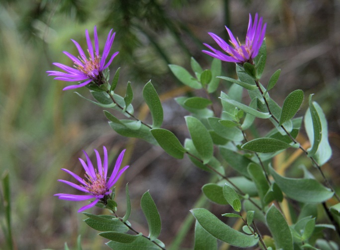
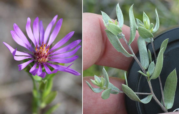
Western Silvery Aster is a perennial wildflower, 30 to 70 cm tall, that produces several to many sparsely branched upright stems. The leaves have long silky hairs giving it a silvery appearance, and this feature together with their lance-shape leaves and woody rootstock, distinguishes it from other asters (Figure 1, Semple 1988). Plants flower from early August to mid September. The inflorescence is branched, and densely hairy, bearing usually less than 10 heads of flowers with rose-purple petals (sometimes white), although some flowering stems can have up to 50-60 flowering heads (Figure 1). Stems are produced from an enlarged, bulblike woody base (called a corm) located just below the soil surface (COSEWIC 2000), and several Western Silvery Aster clumps may be connected by underground rhizomes (Jones 1978, Semple et al. 1996). Shoots for the next season are produced by early September with the tips just below the soil surface. Seeds are produced by early October (Robson 2010a).
3.2 Species Population and Distribution
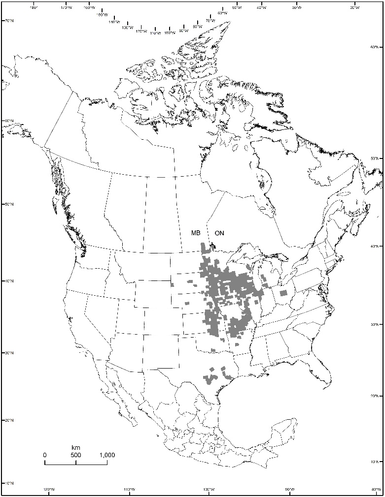
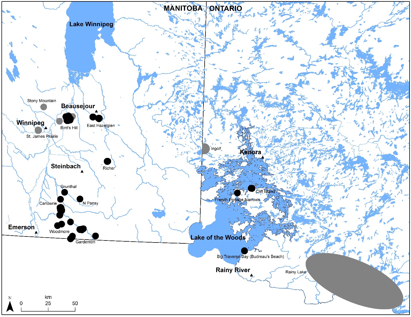
Western Silvery Aster is widespread in central North America ranging from Texas, north through the Midwestern United States to Manitoba and Ontario, Canada, and east as far as Ohio and Tennessee (Figure 2). It is frequent in the Great Plains of the United States and becomes rare in the northern and eastern portion of its range. Western Silvery Aster reaches the northern limit of its range in southeastern Manitoba and northwestern Ontario. As of 2014, there were 23 known extant
In Ontario, there are three extant populations (Big Traverse Bay (Budreau’s Beach), French Portage Narrows, and Cliff Island) and two additional populations (Rainy Lake and Ingolf) which are considered historic and extirpated
In Manitoba, Western Silvery Aster occurs from northeast of Winnipeg south to the US border (Figure 3, Appendix A) as 20 extant populations in four general areas: the Bird’s Hill gravel esker complex northeast of Winnipeg, southeastern Manitoba within the Rural Municipalities of Hanover, Franklin and Stuartburn, near the town of Beausejour, and east of St. Ann. At least 4 additional Manitoba populations are considered extirpated due to gravel extraction and/or urban development, and there are portions of extant populations which have been destroyed by threats like gravel extraction (Appendix A). A population was recorded near the town of Arnaud in 1939 but subsequent searches have not located appropriate habitat and the Manitoba Conservation Data Center does not have a record of this population (COSEWIC 2000).
3.3. Needs of the Western Silvery Aster
a.) Habitat needs
Vegetation associates and abiotic conditions
In Manitoba, Western Silvery Aster inhabits prairies, fields and openings in Bur Oak (Quercus macrocarpa)/Trembling Aspen (Populus tremuloides) woodlands, usually on south or west facing slopes (Semple 1988, COSEWIC 2000). Preferred substrates are “coarse, calcareous sand and gravel with little loam, sandy pockets and cracks in sandstone and limestone outcrops, and thin loamy soil over Canadian Shield” (Semple 1988). Most populations are on a series of beach ridges and nearshore deposits of calcareous sand and gravel marking a former shoreline of Glacial Lake Agassiz (COSEWIC 2000). Populations also exist on gravel eskers and small surficial gravel lenses (trapped gravel patches buried by other soil deposits) surrounded by finer soils. One historical site was found on sandy soil. The extirpated population at Stony Mountain was likely on a limestone outcrop. Well drained near-surface gravel and limestone outcrops are discontinuous in southern Manitoba.
In Ontario, Western Silvery Aster grows in grassy openings in Bur Oak savannah (Upland Bur Oak
Some natural disturbance such as grazing or fire may be required to maintain open habitat conditions, and the species appears moderately tolerant of human-caused disturbances that mimic these natural disturbance regimes (such as appropriately timed mowing), given its habit of growing in fields and road right-of-ways (Semple 1988, Oldham et al. 2003).
b.) Biological needs and limiting factors
Vegetation associates and abiotic conditions
Western Silvery Aster reaches the northern extreme of its range in Canada suggesting that climate may be a factor limiting expansion in Manitoba and Ontario. Populations at the limits of a species’ range often occupy poorer habitat and are more fragmented, less dense, and more variable than those at their core range (Channell and Lomolino 2000, Vucetich and Waite 2003). Peripheral populations are therefore more vulnerable to extinction due to low immigration rate, disrupted pollinator relationships, and other density-related factors. Genetic diversity is sometimes, but not always, less in peripheral populations, but they may possess unique genetic characteristics (Vucetich and Waite 2003).
Western Silvery Aster possesses many of the characteristics of a stress tolerant plant, including a perennial corm and rhizomes, small leaf size, slow growth and sparse litter production (Grime 2001, Robson 2010b). Stress tolerant plants are capable of growing in low nutrient soils and tend to favour conservative growth and nutrient storage, rather than reproduction (Grime 2001). Flower and seed production in Manitoba appears to be inhibited by competition with other plants for pollinators during part of the year, the presence of weevil seed predators, and the low availability of soil resources (Robson 2010b). Issues such as limited genetic diversity may cause low seed set, but this has not been examined in Canada (Robson 2010b).
Pollination and pollinators
Western Silvery Asters are self-incompatible and require cross-pollination by insects. In Manitoba, 22 insect taxa (Diptera and Hymenoptera) visit Western Silvery Aster flowers, with the Two Form Bumble Bee (Bombus bifarius) the most frequent visitor overall, followed by the syrphid fly (Toxomerus spp.) (Robson 2010a). In Ontario, pollinators for Western Silvery Aster are unknown. Seed set is low in Western Silvery Aster in Manitoba due to competition with other co-flowering plants for pollinating insects, particularly earlier in the season, but may also indicate low insect fidelity to Western Silvery Aster plants during foraging by pollinators (Robson 2010a, b). Between 2 to 4 Western Silvery Aster stems/m2 appears desirable to adequately attract insect visitors and ensure maximum seed production. The presence of a range of other co-occurring flowering plant species was optimal to support a permanent population of pollinating insects (Robson 2013). Disruption of pollination biology is a potential limiting factor, particularly at the periphery of the range where both plant and pollinator populations may be fragmented.
4. Threats
4.1. Threat assessment
The Western Silvery Aster threat assessment is based on the IUCN-CMP (World Conservation Union–Conservation Measures Partnership) unified threats classification system. Threats are defined as the proximate activities or processes that have caused, are causing, or may cause in the future the destruction, degradation, and/or impairment of the entity being assessed (population, species, community, or ecosystem) in the area of interest (global, national, or subnational). In carrying out the threat assessment, only present and future (within a 10-year timeframe) threats are considered. Threats are characterized here in terms of scope, severity, and timing. The overall threat “impact” reflects a reduction of a species population or decline/degredation of the area of an ecosystem and is calculated from scope and severity. See the table footnotes for details on how the values are assigned in the table (Table 2). Historical threats, indirect or cumulative effects of the threats, or any other relevant information that would help understand the nature of the threats are presented in the narrative section. Limiting factors are not considered during this assessment process.
| Threat | Threat description | Impact | Scope | Severity | Timing | Detailed threats/Comments |
|---|---|---|---|---|---|---|
| 1 | Residential and commercial development | Low | Small | Extreme | High | |
| 1.1 | Housing and urban areas | Low | Small | Extreme | High | Residential development; shoreline and/or cottage development |
| 1.3 | Tourism and recreation areas | Low | Small | Serious | High | Campground and parking lot expansion or increase in recreation in adjacent areas; golf course expansion; shoreline development |
| 2 | Agriculture and aquaculture | Low | Small | Extreme | High | |
| 2.1 | Annual and perennial non-timber crops | Low | Small | Extreme | High | Cultivation |
| 2.3 | Livestock farming and ranching | Negligible | Small | Negligible | High | Overgrazing |
| 3 | Energy production and mining | High | Large | Extreme | High | |
| 3.2 | Mining and quarrying | High | Large | Extreme | High | Gravel extraction |
| 4 | Transportation and service corridors | High | Large | Extreme | High | |
| 4.1 | Roads and railroads | High | Large | Extreme | High | Road construction and maintenance activities (mowing and pesticide spraying are captured under 7.3 and 9.3, respectively.) |
| 4.2 | Utility and service lines | Low | Small | Slight | High | Transmission line right of way maintenance and construction; hydro line right of way |
| 6 | Human intrusions and disturbance | Low | Small | Slight | High | |
| 6.1 | Recreational activities | Low | Small | Slight | High | Off-road all-terrain vehicle (ATV) use and trails; horse trails; hiking trails; hiking off dedicated trails; shore lunch sites; temporary campsites |
| 7 | Natural system modifications | Low | Large | Slight | High | |
| 7.1 | Fire and fire suppression | Unknown | Unknown | Unknown | Unknown | Fire suppression |
| 7.3 | Other ecosystem modifications | Low | Large | Slight | High | Mowing at inappropriate times (right of ways, roadsides) |
| 8 | Invasive and other problematic species and genes | Medium | Large | Moderate | High | |
| 8.1 | Invasive non-native/alien species | Medium | Large | Moderate | High | Invasive alien plant species |
| 8.2 | Problematic native species | Low | Restricted | Slight | High | Encroachment of shrubs or woody growth through natural vegetation succession. Interaction with improper management activities, climate, lack of natural disturbances. Seed predation. |
| 9 | Pollution | High | Restricted | Extreme | High | |
| 9.3 | Agricultural and forestry effluents | High | Restricted | Extreme | High | Non-specific pesticide and neonicotinoid use |
| 11 | Climate change and severe weather | Low | Large | Slight | Moderate-low | |
| 11.2 | Droughts | Low | Large | Slight | Moderate-low | |
| 11.4 | Storms and flooding | Unknown | Small | Unknown | Unknown | Increased summer storms potentially causing greater erosion of cliff sites |
4.2 Description of threats
Appendix A identifies the threats that are associated with each population.
IUCN Threat 1: Residential and commercial development
Threat 1.1 Housing and Urban Areas
Residential development contributed to the loss of at least four populations in Manitoba (Appendix A). Residential development could also further impact at least two other populations in Manitoba (Appendix A, COSEWIC 2000). Private and municipal lands south of the Bird’s Hill Provincial Park lie within the Rural Municipality of Springfield, one of the fastest-growing municipalities in Manitoba’s Capital Region (Lorch 2002). Residential development can not only lead to the direct loss of a population through the housing development itself, but it can indirectly impact a population by altering the occurrence and frequency of disturbance events required to maintain suitable habitat conditions, increasing the introduction and spread of invasive species, altering the hydrology and nutrients the habitat receives, and increasing the amount of trampling through recreational use of surrounding lands. Infrastructure associated with development, such as installation and maintenance of utility lines, road expansion or alteration, and clearing and maintenance of ditches may also be a concern since many populations are found along roadsides or right-of-ways (see threat 4.1, 4.2, 7.3).
Development of shoreline lots for cottages is a potential threat at Big Traverse Bay (Budreau’s Beach) in Ontario (Ben-Oliel and Oldham 2000). Several cottages have been constructed within the area occupied by Western Silvery Aster and other lots have been designated for cottage development (Oldham et al. 2003). Less than 10% of the Western Silvery Aster plants occur on developed lots, with about a third of the population on potential cottage lots and the remainder on inland sites not under immediate threat of development (Harris et al. 2005). A roadway through the Big Traverse Bay (Budreau’s Beach) site has caused some damage to the population.
Threat 1.3 Tourism and recreation areas
There are two campgrounds within close proximity to Western Silvery Aster populations (Appendix A), and expansion into the areas containing Western Silvery Aster could pose a threat, as could an increase in use of the prairie by visitors to the campground or parks. There is also a golf course adjacent to a known population (Appendix A); this golf course may have eliminated a portion of that population historically. Expansion of the golf course and the increased input of moisture and fertilizers could pose a threat to a portion of the population.
IUCN Threat 2: Agriculture and aquaculture
Threat 2.1 Annual and perennial non-timber crops
In Manitoba, it is estimated that tall-grass prairie habitat has declined 99.9% from its original 600,000 hectares, largely due to cultivation for forage and cereal crops (Samson and Knopf 1994). This has resulted in considerable historical habitat loss for species like Western Silvery Aster. Many of the remaining populations are in remnant strips of native prairie between cultivated fields and roadsides and may be further impacted by cultivation of the remaining strips, pesticide drift (threat 9.3) or encroachment of tame forage species from adjacent cultivated fields (threat 8.1). Those populations still in larger tracts of native pasture may be at risk of future cultivation in years where crop prices are high (Honey and Oleson 2006, Farm Credit Canada 2013, Wright and Wimberly 2013).
Threat 2.3 Livestock farming and ranching
Pre-settlement, habitat containing Western Silvery Aster would have evolved under periodic natural disturbances like fire, grazing and drought (Samson and Knopf 1994). These disturbances interacted independently and/or together (Collins 1987), to maintain the open, early successional habitat suitable for species like Western Silvery Aster. In the absence of these disturbances, woody vegetation or invasive alien species can encroach and litter levels can increase, leading to a change in the plant community (threats 8.1, 8.2; Higgins et al 1989, Milchunas et al. 1989, Milchunas et al. 1992, Samson and Knopf 1994, Hayes and Holl 2003). Post-settlement, alterations to grazing from what traditionally occurred with wild ungulates, have contributed to changes in the plant and animal communities and ecosystem processes of tall-grass prairie habitat (Samson and Knopf 1994, Knapp et al. 1999, Fuhlendorf and Engle 2001, Towne et al. 2005). Studies have shown processes (grazing, fire, or the combination of both) that influence vegetation composition and structure in grasslands, interact with limiting factors in the environment such as precipitation (drought) or soil nutrients, to create an optimum state for the system (Wedin 1994, Biondini et al. 1998). Grazing influence is likely determined by a combination of factors including grazing history of the landscape, climatic conditions (e.g. drought), and the length of time certain conditions persist (Biondini et al. 1998, Knapp et al. 1999). Although overgrazing has been reported to be a concern for Western Silvery Aster at a few populations (Appendix A), the impact of grazing in terms of frequency, scale and intensity on Western Silvery Aster populations and habitat is largely unknown at this point. It is possible that intensive grazing could damage the woody corm at and just below the surface of the soil. Grazing at the time of year when the plant is flowering or setting seed may result in reduced seed set if plants are grazed or trampled. It was reported that one population in an intensively grazed pasture had fewer Western Silvery Aster plants than an adjacent ungrazed area. Responsible grazing at appropriate intensity, frequency and duration, however, is likely not detrimental in a system that evolved under grazing pressure, and in fact, is likely beneficial by preventing succession, maintaining vegetation structure, and maintaining range condition (Higgins et al 1989, Milchunas et al. 1989, Milchunas et al. 1992, Samson and Knopf 1994, Biondini et al. 1998) .
IUCN Threat 3. Energy production and mining
Threat 3.2 Mining and quarrying
In Manitoba, the glacial beach ridges, eskers, and gravel lenses inhabited by the Western Silvery Aster contain valuable gravel deposits. More than half of the populations of Western Silvery Aster in Manitoba are currently adjacent to or within active gravel pits with a few others near old gravel pits. Gravel extraction may have been a contributing factor in the extirpation of the Stony Mountain population in Manitoba. It has also resulted in reduced population size at several extant populations in Manitoba, including destroying some habitat and plants at the population near Bird’s Hill Provincial Park (Appendix A). Gravel extraction results in direct loss of plants and habitat, alters hydrology, fragments habitat, and increases the potential for invasive plant species to colonize disturbed areas. With the continued need for aggregate it is likely that additional populations of Western Silvery Aster in Manitoba will be threatened by new gravel pits or expansion of existing gravel pits. In Ontario, gravel extraction is not an apparent threat because none of the populations occur within appreciable surficial deposits.
IUCN Threat 4. Transportation and service corridors
Threat 4.1 Roads and railroads
More than half of the Western Silvery Aster populations in Manitoba are partially or entirely on remnant pieces of native prairie along roadsides and ditches (Appendix A). Habitat and plants can be damaged or destroyed by road construction activities such as road widening, ditch deepening, trenching, drainage projects, and realigning or improving the road. Habitat and plants can also be affected by incompatible or inappropriately-timed road maintenance activities on shoulders and in ditches, such as spraying pesticides (threat 9.3), grading, haying or mowing (threat 7.3). The linear disturbances from roads also increase the potential for introduction and invasion by invasive alien species which may compete with Western Silvery Aster (threat 8.2). The linear disturbances and resultant habitat fragmentation may also impact animal movement, which may indirectly impact Western Silvery Aster seed dispersal among populations.
Threat 4.2 Utility and service lines
A few populations have been impacted in the past by construction and maintenance activities along transmission or hydro right of ways, including line extraction and tower removal. Future installation, maintenance, upgrading or decommissioning of these right of ways could impact populations that are adjacent to, or within, the utility right of ways. Populations in ditches near urban centres, recreation areas, or cottage developments may be at higher risk as infrastructure like utility right of ways will be installed or upgraded. Similar to roads, utility lines can result in fragmentation of habitat as well as introduction of invasive species.
IUCN Threat 6. Human intrusions and disturbance
Threat 6.1 Recreational activities
Operation of off-road recreational vehicles, including all-terrain vehicles (ATV), in ditches and along trails can damage or destroy plants, compact or erode soil, and cause unnatural disturbance to habitat which increases opportunities for colonization by invasive alien plants. It can also introduce invasive alien plants from seed that falls from the vehicle. ATV use was reported as a threat at three Western Silvery Aster populations (Appendix A). Near Bird’s Hill, ATV use that resulted in mild disturbance in areas where thatch build-up and/or shrub encroachment are threats has been found to be potentially beneficial in maintaining open habitat conditions for Western Silvery Aster. Other recreational activities, like a horse trail (Bird`s Hill) or hiking trails (Bird`s Hill, Big Traverse Bay (Budreau’s Beach)), can also lead to damage to plants if use of the trails is heavy. Increased recreational use associated with existing and potential cottage developments and campgrounds is also a potential threat at a few populations (Appendix A; threats 1.1 and 1.3). Intermittent activities such as shore lunch sites, campsites, and hiking off designated trails has been identified as a low threat to the three existing populations in Ontario. These types of activities can cause trampling of Western Silvery Aster plants and surrounding vegetation, as well as displacement or compaction of soil.
IUCN Threat 7. Natural system modifications
Threat 7.1 Fire and fire suppression
As discussed in threat 2.3, Western Silvery Aster habitat would have evolved under a natural disturbance regime that included ecological processes such as grazing and fire, acting independently or together (Daubenmire 1968, White 1979, Collins 1987, Lesica and Cooper 1999). Changes in land use practices since European settlement has resulted in reduction in the frequency and extent of prairie fires (Higgins et al. 1989). While natural disturbance is required to disrupt natural succession to woody vegetation and maintain the open habitat conditions required by this species, the level of tolerance of Western Silvery Aster to fire in terms of frequency, intensity, and timing is unknown. The relative cover of Western Silvery Aster increased in Kansas after a prescribed burn (Gibson and Hurlbert 1987). However, in Manitoba, Western Silvery Aster flowering stem density increased with higher lichen and club moss cover (Robson 2010b), and these spore bearing plants may be slow to recover, particularly after a higher intensity fire (Callison et al. 1985, Johansen et al. 1984, Wilson and Shay 1990, Belnap et al. 2001). At Cliff Island, French Portage Narrows, and Big Traverse Bay (Budreau’s Beach), Ontario, shallow soils help limit tree and shrub invasion but lack of regular fire is still a concern. The site at Cliff Island is quite shrubby and estimates of the number of Western Silvery Aster stems in 2014 were considerably lower than in 2001. In Manitoba, succession of woody species or invasive alien species has been reported for numerous populations (Appendix A). Frequent prescribed fire has been found to reduce seed herbivory in some plants (Vickery 2002) but the interaction between fire frequency and seed predation in Western Silvery Aster is unknown.
Threat 7.3 Other ecosystem modifications
Haying or mowing is a beneficial management practice for many prairie species, as it can reduce litter or control invasive alien plant species. Mowing is commonly used along road or utility right of ways and ditches to control invasive alien plant species or reduce vegetation height for public safety. However, inappropriately timed haying or mowing can cause physical damage to plants, remove the flowering head before seed set, or remove the seed head before seed has dispersed, thereby reducing seed production. A negative effect of clipping on Western Silvery Aster stem height was observed in a study by Robson (2010b). Removal of flowers also affects pollinators of Western Silvery Aster (see limiting factors). Repeated mowing during flowering or seed set over many years could have an impact on population size or pollinator communities. Depending on the equipment used, mowing may also leave thatch behind, increasing shading or altering moisture levels and microhabitat. All Western Silvery Aster populations occurring in roadsides or other right of ways could be impacted by inappropriately timed mowing (Appendix A).
IUCN Threat 8. Invasives and other problematic species and genes
Threat 8.1 Invasives and other problematic species and genes
Invasive alien plants can pose a direct threat through competition because they are aggressive and can displace native species, decrease species diversity or richness through their superior competitive ability and/or result in overall negative effects on ecosystem functioning (Wilson 1989, Wilson and Belcher 1989, Reader et al. 1994, Dillemuth et al. 2009, Koper et al. 2010). In Manitoba, agricultural land, roadsides/ditches, and residential or recreation areas surround most populations and the risk of invasion is much higher in these disturbed areas. Smooth Brome (Bromus inermis), Leafy Spurge (Euphorbia esula), sweet clover (Melilotus alba and M. officinale), Kentucky Bluegrass (Poa pratensis), thistle (Cirsium sp. or Carduus sp.), Reed Canarygrass (Phalaris arundinacea, European form), and Spotted Knapweed (Centaurea stoebe) are some of the main invasive alien plant species occurring with populations of Western Silvery Aster in Manitoba and may pose a threat to its habitat (Appendix A). In Ontario, Common Tansy (Tanacetum vulgare) and Quackgrass (Elymus repens) were reported at the population in Big Traverse Bay (Budreau’s Beach) but are largely restricted to the immediate vicinity of the cabins and road (Oldham et al. 2003), although future development could encourage the spread of these plants. European Reed (Phragmites australis) and Reed Canarygrass may pose a threat to populations occupying ditches in the future (Environment Canada 2014a, Environment Canada 2014b). Inappropriate use of herbicide intended to control invasive species has the potential to directly kill Western Silvery Aster plants, or to negatively alter habitat occupied by Western Silvery Aster (threat 9.3).
Threat 8.2 Problematic native species
In the absence of natural disturbances like fire or grazing, or during extended wet climatic periods, woody vegetation can encroach and litter levels can increase, leading to a change in the plant community (Higgins et al 1989, Milchunas et al. 1989, Milchunas et al. 1992, Samson and Knopf 1994, Hayes and Holl 2003). The disruption of the natural disturbance regime has allowed encroachment of woody vegetation and other competition at some Manitoba sites (COSEWIC 2000). Suppressing fire allows trees and shrubs to invade prairies and savannahs, allows invasive weed species to gain a foothold, may increase susceptibility to weevil seed predation (Vickery 2002) and has been a contributing factor in declines of other prairie plant species (Kaye et al. 2001). Encroachment and thatch build-up can result in increased competition for limited resources, such as sunlight, can limit availability of suitable sites for establishment, and can alter moisture and temperature levels which may affect germination. Encroachment of woody vegetation is a potential threat to several Manitoba populations and at Cliff Island and French Portage Narrows in Ontario (Appendix A).
Seed predation may have a significant impact on rare plants when population size is low (Evans et al. 1989, Bevill et al. 1999, Vickery 2002). In Manitoba, 37% of flowering heads were damaged by insect seed predators, particularly by Anthonomus weevils (Newman 1999, COSEWIC 2000, Robson 2010b) which lay an egg at the base of the flower at or before bloom which destroys all the seeds in the flowering head. In another native grassland plant, New England Blazing Star (Liatris scariosa var. novae-angliae), frequent prescribed fire reduced seed herbivory (Vickery 2002); the interaction between fire frequency and seed predation in Western Silvery Aster is unknown.
IUCN Threat 9. Pollution
Threat 9.3 Agriculture and forestry effluents
The indiscriminate or inappropriate use of pesticides intended to control undesirable plants (broad-leaf herbicide) or insect pests (indirectly through herbicide or directly through insecticide) in right of ways, ditches, or adjacent fields can affect Western Silvery Aster plants and its pollinators. Pesticide use or chemical drift was reported as a threat for three populations, but this likely affects more populations in Manitoba due to the high proportion of populations in roadside ditches or adjacent to cultivated fields. Broad-leaf herbicides if sprayed on Western Silvery Aster will kill the plant; targeted applications or other means of invasive species control are required in areas with Western Silvery Aster populations. Reducing flowering plants through herbicide use, as well as spraying insecticides to control insect pest species, can both reduce pollinators and potentially affect reproduction of Western Silvery Aster. Western Silvery Aster depends primarily on insect pollinators to ensure sufficient seed production (Robson 2010a, 2010b, 2013; see limiting factors). The syrphid fly, a main pollinator of Western Silvery Aster, is a predator of small insects as larvae and may be indirectly affected by insecticide use causing a lack of insect prey. Declining native bee populations across North America have been observed to coincide with declines in native plant populations, although it is not clear whether bee declines are causing plant declines or vice versa (Nabhan and Buchmann 1997, Kearnes et al. 1998, Scheper et al. 2014, Gill and Raine 2014, Godfray et al. 2014).
As of 2014, neonicotinoids were being used on more than 40 million hectares of cropland in the United States and are now the most widely used insecticide in the world, trends that are consistent with the Canadian use of this insecticide (Douglas and Tooker 2015). Research has shown that even sublethal exposure to this insecticide can cause acute and chronic effects in pollinating species, specifically in social bees (honeybees, bumblebees, and stingless bees) (Gill and Raine 2014, Godfray et al. 2014). Chronic exposure to sublethal doses of neonicotinoids can alter bumblebee (Bombus spp.) behaviour including changing forager preferences for flower types, impairing forager performance (carry out fewer foraging bouts and bring back smaller pollen loads), and impair bee learning performance (Gill and Raine 2014, Godfray et al. 2014). Bumblebees are the main pollinator of Western Silvery Aster and effects from changes in bee behaviour could be exacerbated by the competition for pollinators with other co-flowering plants (Robson 2010a, b). Considering the high proportion of Western Silvery Aster populations in Manitoba that exist adjacent to cultivated fields, this threat may be more prevalent than initially reported.
IUCN Threat 11. Climate change and severe weather
Threat 11.2 Droughts
Although Western Silvery Aster exhibits stress-tolerant characteristics that make it capable of growing in gravelly, well-drained, low-nutrient soils, moisture may be a limiting factor in reproductive output of Western Silvery Aster (Robson 2010b). Periods of drought may reduce seed production in Manitoba populations (COSEWIC 2000). In 1998, some populations, especially those in the Bird’s Hill Provincial Park area, failed to produce mature heads. At other sites in Manitoba, heads were produced but no seeds were set (R. Staniforth pers. comm., E. Punter 1998 personal observation). Failure to produce heads and seeds was probably the result of low precipitation in August and early September (R. Staniforth & E. Punter, 1998 personal observation).
Threat 11.4 Storms and flooding
An increase in summer storms, as a result of climate change, has the potential to cause greater erosion on cliff sites inhabited by Western Silvery Aster. This may become a concern at two populations (Cliff Island and French Portage Narrows) which occur in the Lake of the Woods region in Ontario. The impact, severity, and timing of this threat is unknown at this time. Further research or modeling is required to fully understand the implications of this threat to these populations.
5. Population and Distribution Objectives
The population and distribution objective for the Western Silvery Aster is to maintain the overall population size and distribution
At this time, it is not feasible to define quantitative population objectives because there are no accurate estimates of population size, long-term data on population trends, or understanding of the range of natural variability for the Western Silvery Aster populations. While baseline estimates of population size are available for most populations (Appendix A), these data are insufficient to describe trends or to compare populations, because of inconsistent survey and monitoring methods among years. Standardized methodology is needed to accurately estimate population sizes and quantify the natural range of variation in abundance within and between populations. Once this is established, quantitative population objectives may be able to be defined.
A decrease in the distribution of Western Silvery Aster could reflect a loss of both habitat and individuals. Maintaining the species’ distribution at the current levels will help ensure the extent of occurrence and index area of occupancy are maintained, preventing the species from being evaluated as “declining” in future COSEWIC assessments, as per the COSEWIC criteria in either category A, “decline in total number of mature individuals”, category B, “small distribution range and decline or fluctuation”, or category C, “small and declining number of mature individuals” (COSEWIC 2012). Therefore, until reliable and accurate population estimates are available, establishing quantitative distribution objectives is a more meaningful approach for recovery planning purposes for this species.
Appropriate stewardship actions that maintain or increase habitat quality may benefit Western Silvery Aster populations. If habitat quality and quantity continue to decline, however, known populations will also decline as a result. Therefore, quantitative distribution objectives are set in the context of needing to reverse or prevent further declines in the quality and quantity of habitat through mechanisms and tools such as: beneficial management practices, conservation agreements, and stewardship arrangements.
6. Broad Strategies and General Approaches to Meet Objectives
6.1. Actions Already Completed or Currently Underway
Manitoba
- Manitoba Conservation Data Centre staff have conducted inventories of Western Silvery Aster in Manitoba in 2001, 2004, 2005, 2006, 2009, 2010 and 2013 (Reimer and Hamel 2002, Hamel and Foster 2005, Foster and Hamel 2006, Foster and Reimer 2007, Friesen and Murray 2010, 2011).
- In 2008, possible causes of low seed production in Western Silvery Aster were examined at Bird’s Hill Provincial Park, Manitoba. The effects of pollinator competition and seed predation were examined, as well as the impact on flower and seed production of clipping surrounding vegetation and/or fertilizing with nitrogen (see Robson 2010a, 2010b, 2013).
- In 2006 and 2009, the Manitoba Conservation Data Centre prepared maps of road allowances highlighting the location of Western Silvery Aster for the Rural Municipalities of Franklin and Stuartburn in Manitoba to help mitigate threats associated with road maintenance activities and mowing (Foster and Reimer 2007, Friesen and Murray 2010).
Ontario
- Surveys for new populations have been conducted at Lake of the Woods and Rainy Lake by Ontario Natural Heritage Information Centre staff and Ontario Ministry of Natural Resources and Forestry (OMNRF) Kenora District staff.
- The Big Traverse Bay (Budreau’s Beach) population in Ontario has been systematically surveyed in 2002, 2007 and 2012 (Oldham et al. 2003, Van den Broeck and Elliott 2007, Van den Broeck 2012). Stewardship actions by the landowner have increased the density and distribution of Western Silvery Aster at this location since 2002. OMNRF Fort Frances District staff have also been involved in surveys of this population.
- A provincial regulation was enacted under the Ontario ESA in February 2010 to protect the species and its habitat at Cliff Island and Big Traverse Bay (Budreau’s Beach); The French Portage Narrows population does not currently receive habitat protection under the Ontario ESA, although its location within a Provincial Park affords some habitat protection.
- The French Portage Narrows population was discovered and surveyed in 2014 by OMNRF Kenora District staff.
6.2. Strategic Direction for Recovery
| Broad strategy | Threat number or limitation | Priority | General Description of Research and Management Approaches |
|---|---|---|---|
| Habitat assessment, management and conservation | All except 11.2 and 11.4 | High |
|
| Communication, collaboration and engagement | 1.1, 1.3, 4.1, 4.2, 6.1, 7.1, 7.3, 8.1, 8.2, 9.3 | Medium-High |
|
| Research as part of an adaptive management framework | All threats, limiting factors/ knowledge gaps | High |
|
| Research as part of an adaptive management framework | All threats, limiting factors/ knowledge gaps | Medium |
|
| Inventory and monitoring | All threats, supports measuring of progress towards achieving the population and distribution objective | Medium |
|
| Inventory and monitoring | All threats, supports measuring of progress towards achieving the population and distribution objective | High |
|
6.3. Narrative to Support the Recovery Planning Table
Due to the continued loss of habitat quality and quantity, and the limited number of populations, the most important recovery activity for Western Silvery Aster will be habitat conservation and stewardship through conservation agreements or stewardship arrangements. This will be particularly important for populations at immediate risk from threats like gravel extraction or road construction and maintenance. Implementation of best management practices for mowing, burning and grazing are also high priority activities to investigate because they may represent a threat if applied intensively or at inappropriate times in the life cycle of Western Silvery Aster, but may be useful management practices for maintaining habitat when applied appropriately. Research into habitat and species’ needs may be required to refine management practices, and adaptive monitoring is warranted before and after implementation to determine the habitat and population response. Effective communication strategies will be necessary to reduce some threats and change perceptions about conservation and management approaches.
Research into aspects of Western Silvery Aster ecology such as seed bank dynamics, seed viability, seed germination requirements, seed dormancy, seedling survival, and seed dispersal, recruitment, generation time is a medium priority. This information is required to understand population demographics, reproductive ecology, dispersal and recruitment, and resiliency to various types of disturbance and will help inform best management practices and a better informed definition of critical habitat. Research on seed viability and germination requirements may already be available from native plant/seed suppliers in Manitoba and research on the pollination biology of Western Silvery Aster has already begun. Finally, research is needed to determine whether the small size and isolation of many local populations of Western Silvery Aster represents a threat to genetic diversity and/or population viability of the population as a whole. This type of information will help determine the feasibility of restoration efforts and when/if restoration efforts would be deemed necessary.
Education and communication efforts are needed to ensure that Western Silvery Aster populations on public lands are recognized during land use planning, recreation, and maintenance or construction activities. Raising awareness among key landowners, land managers and land users on private and public land will help to ensure that land management practices benefitting the species can be implemented.
Information on the impacts of human-related threats and habitat management techniques on the ecology and habitat needs of Western Silvery Aster is relevant to long-term conservation and management. More specifically, research and adaptive management are needed to evaluate the magnitude and direction of threats and mitigation effects on plant fitness, population size, and area of occupancy. Ex-situ or in situ experimental and observational field investigations that could be undertaken include examining the effects, timing and intensity of grazing, fire, invasive species control, brush control, mowing, and idled
Regular monitoring is needed to determine the natural range of variability, trends, and health of the populations (including seed production and recruitment). Baseline estimates of population size are available for most extant populations but repeated and consistent monitoring of population size and area of occupancy is lacking. Threats such as human disturbance, vegetation succession and invasion of exotic species should be incorporated into the monitoring protocol. Monitoring will also track whether the population and distribution objectives are being met at extant sites. To support population recovery and management, a population viability analysis is required to develop quantitative targets for the population objectives. Surveys of potential habitat are needed because there are still unsurveyed parcels of native prairie (e.g. Bur Oak savannah) where Western Silvery Aster may reside, particularly in the Lake of the Woods area in northwestern Ontario, and in larger pastures in Manitoba.
7. Critical habitat
7.1. Identification of the Species’ Critical Habitat
Critical habitat is defined in the Species at Risk Act (SARA) section 2(1) as “the habitat that is necessary for the survival or recovery of a listed wildlife species and that is identified as the species’ critical habitat in the recovery strategy or in an action plan for the species”. Section 41 (1)(c) of SARA requires that recovery strategies include an identification of the species’ critical habitat, to the extent possible, as well as examples of activities that are likely to result in its destruction.
Critical habitat for Western Silvery Aster is fully identified for all 23 known extant populations in Canada (20 in Manitoba and 3 in Ontario), to the extent possible, based on the best available information
7.1.1 Critical Habitat Identification in Manitoba
The approach used for identifying critical habitat for Western Silvery Aster in Manitoba is based on a decision tree developed by the Recovery Team for Plants at Risk in the Prairie Provinces as guidance for identifying critical habitat for terrestrial and aquatic prairie plant species at risk (Appendix A in Environment Canada 2012). Since Western Silvery Aster occupies habitat that usually has distinct boundaries well-defined in space and time, and because it is a perennial, reliably present and easy to detect during the flowering period, critical habitat is identified as per the criteria for 3a of the decision tree (Appendix A in Environment Canada 2012). Critical habitat for Western Silvery Aster in Manitoba is identified as the extent of suitable habitat occupied by the species
Although the exact extent of habitat needed to surround Western Silvery Aster plants to fulfill the reproductive, dispersal and long-term survival needs of the population is not fully known, the 300 metre critical function zone is based upon a detailed literature review that examined edge-effects of various land use activities that could affect resource availability and contribute to negative population growth for native prairie plants generally (Henderson 2010b; Appendix B in Environment Canada 2012). Based on a detailed literature review that examined factors affecting the quality of native prairie patches in the tall-grass prairie of Manitoba, and the pollination biology of Western Silvery Aster, the 300 metre critical function zone is appropriately applied to critical habitat identification of Western Silvery Aster in Manitoba (Environment Canada 2015 unpublished review). This approach is consistent with the critical habitat identification for a number of other prairie plant species that occupy similar type habitats (e.g. Tiny Cryptantha Cryptantha minima, Slender Mouse-ear-cress Halimolobos virgate, Western Spiderwort Tradescantia occidentalis, Rough Agalinis Agalinis aspera). Thus, to ensure the long-term persistence, and where feasible, the natural expansion, of Western Silvery Aster in Manitoba, the 300 metre critical function zone is thought to be the minimum distance needed to maintain the habitat required to meet the population and distribution objectives. As new information on species’ habitat requirements and site specific characteristics become available, this distance may be refined.
7.1.2 Critical Habitat Identification in Ontario
In Ontario, the biophysical attributes of suitable habitat for Western Silvery Aster are best described using the Forest Ecosystem Classification for Northwestern Ontario (FEC) (Sims et al. 1997). The FEC framework provides a standardized approach to the interpretation and delineation of dynamic ecosystem boundaries. This system classifies habitats not only by vegetation community; it also considers soils and moisture, and as such encompasses the biophysical attributes of habitat for Western Silvery Aster in Ontario (Table 4). Within the FEC system in Ontario, the vegetation type containing Western Silvery Aster has been described as Upland Bur Oak (V3.3 vegetation type). The Upland Bur Oak vegetation type is generally described as having stunted, often widely spaced trees on savannah-like sites that have a warmer than average microclimate (Sims et al. 1997). The understory is described as being high in species diversity with both an abundance of graminoid (grasses) species and few shrubs or abundant with shrubs (Sims et al. 1997).
| Biophysical Attributes | Description |
|---|---|
| Soils and bedrock geology | south facing, mafic (basic) bedrock slopes with shallow, discontinuous Gray Luvisolic clay soils |
| Surface and sub-surface hydrology | dry to fresh moisture regime with rapid drainage |
| Vegetation and vegetation community composition | grassy savannah-like openings in Upland Bur Oak vegetation communities with a warmer than average microclimate |
| Landforms | landforms such as rocky outcrops and cliff sides |
Within the FEC system, the ecosite boundary best captures the extent of biophysical attributes required by this species. The Upland Bur Oak vegetation type includes the areas occupied by Western Silvery Aster and the surrounding areas that provide suitable habitat conditions (e.g., open, well drained) to carry out essential life processes for the species and should allow for natural processes related to population dynamics and reproduction (e.g., dispersal and pollination) to occur. The habitat patch surrounding the plant may also promote ecosystem resilience to invasive species while protecting what are rare vegetation communities (oak savannahs) in Ontario. Western Silvery Aster may also be able to colonize areas following disturbance (e.g., areas of ingrown savannah).
Critical habitat for Western Silvery Aster in Ontario is identified as the extent of suitable habitat occupied by the species
The 50 metre radial distance used is considered a minimum ‘critical function zone’, or the threshold habitat fragment size required for maintaining constituent microhabitat properties for a species (e.g., essential light, moisture, humidity levels necessary for survival) where it occurs. At present, it is not clear at what exact distances physical and/or biological processes begin to negatively affect Western Silvery Aster and this distance is likely to depend on local habitat characteristics. Studies on micro environmental gradients at habitat edges (light, temperature, litter, moisture) (Matlack 1993), and of edge effects on plants in mixed hardwood forests, as evidenced by changes in plant community structure and composition (Fraver 1994), have shown that edge effects could be detected up to 50 metres into habitat fragments, although other studies show that the magnitude and distance of edge effects will vary depending on the structure and composition of adjacent habitat types (Harper et al. 2005). Research is required to more specifically address the edge effects to savannah ecosystems in Canada. A 50 metre radial distance from any Western Silvery Aster plant is chosen as a precautionary approach to ensure that microhabitat properties are maintained as part of the identification of critical habitat. The area within the 50 metre critical function zone may include both suitable and unsuitable habitat as Western Silvery Aster may be found near the transition zone between suitable and unsuitable habitat (e.g., along woodland edges). As new information on species’ habitat requirements and site-specific characteristics become available, distances may be refined.
Critical habitat is fully identified for all 23 extant populations of Western Silvery Aster in Canada (Table A1), totaling up to 2,826 hectares (28.26 km²) in Manitoba and 14 hectares (0.14 km²) in Ontario. In Manitoba, approximately 124 quarter sections contain critical habitat for the Western Silvery Aster. The general geographic areas containing critical habitat are presented in Appendix B using a standardized 1 x 1 km UTM grid square system (Table B1). In Manitoba, critical habitat is the extent of suitable habitat occupied by the species and all natural biophysical attributes11 that occur within the discrete boundaries represented by the shaded yellow polygons (Appendix B, Figures B1 to B6). In Ontario, critical habitat is the extent of suitable habitat occupied by the species, plus a 50 metre critical function zone around the plants where they occur near the edge of suitable habitat (Appendix B, Figure B7). Due to provincial data sharing agreements in Ontario, critical habitat in Ontario is only presented using the 1 x 1 km UTM grid squares to indicate the general geographic areas containing critical habitat. More detailed information on critical habitat may be requested on a need to know basis by contacting Environment and Climate Change Canada – Canadian Wildlife Service.
7.2. Activities Likely to Result in the Destruction of Critical Habitat
Destruction is determined on a case by case basis. Destruction would result if part of the critical habitat were degraded, either permanently or temporarily, such that it would not serve its function when needed by the species. Destruction may result from a single or multiple activities at one point in time or from the cumulative effects of one or more activities over time. Activities described in Table 5 outline examples of activities likely to cause destruction of critical habitat for Western Silvery Aster; however, destructive activities are not limited to those listed.
Some activities that result in a temporary alteration of critical habitat (e.g., cattle grazing, brush cutting and prescribed burns) may have the potential to contribute to the future quality of critical habitat, given proper management. Some disturbance to Western Silvery Aster habitat may be beneficial to the species by maintaining open habitat and managing invasive species or woody vegetation growth within a given site. Appendix D describes some management practices that may be beneficial to the Western Silvery Aster.
| Description of Activity | Description of effect (on biophysical attribute or other) in relation to function loss of critical habitat | Additional information |
|---|---|---|
| Compression or erosion of soils, which can be caused by activities such as: creation of trails and roads; motorized traffic; or concentration of livestock activity by the placement of bales, or establishment of new corrals or watering sites | Compression and erosion can damage soil structure and porosity, reduce water availability by increasing runoff and decreasing infiltration, prevent establishment of seedlings, or increase the likelihood of invasive alien plants by disturbing native ground cover. | This activity must occur within the bounds of critical habitat to cause its destruction, may result in destruction either directly or cumulatively, and is applicable at all times of the year, with the exception of winter months when the ground is snow covered and frozen solid (soil temperature below -100C). |
| Covering of soils, which can be caused by activities such as: creation or expansion of permanent/ temporary structures such as land conversion to residential/cottage developments; spreading of solid waste materials; or roadbed construction. | Covering the soil prevents solar radiation and water infiltration needed for germination and survival of plants, such that critical habitat is destroyed. | This activity must occur within the bounds of critical habitat to cause its destruction, is a direct effect, and is applicable at all times of the year. |
| Inversion/excavation/extraction of soils, which can be caused by activities such as: new or expanded cultivation; sand and gravel extraction pits; mineral exploration; dugouts; certain road construction and maintenance activities; residential/cottage development; pipeline installation; or removal of topsoil | Inverting, excavating or extracting soil results in the direct loss of critical habitat by removing or disturbing the substrate within which the plant grows, and altering the biophysical conditions (e.g. soil porosity, soil temperature, soil moisture) required for germination, establishment and growth of the Western Silvery Aster. This activity can also lead to vegetation community change to one dominated by competitive invasive species. | This activity must occur within the bounds of critical habitat to cause its destruction, may result in destruction either directly or cumulatively, and is applicable at all times of the year. |
| Alteration to hydrological regimes, which can be caused by activities such as: temporary or permanent inundation from construction of impoundments downslope or downstream; releases of water upslope and upstream, including but not limited to damming, ditching, drainage, culvert installation, road widening or straightening; or residential/cottage developments that affect the hydrology of critical habitat | As the seed bank and plants of Western Silvery Aster are adapted to well-drained soils, flooding or inundation by substances like water, even for a short period of time, can be sufficient to alter habitat enough to be unsuitable for survival and re establishment. Altering hydrology can also result in too dry conditions, mimicking drought. For example, road construction can interrupt or alter overland water flow, altering habitat conditions and threatening the long-term survival of the species at a particular location. An increase in moisture may also lead to increased encroachment by woody vegetation and some invasive plant species. | This activity may result in destruction of critical habitat whether it occurs within or outside the bounds of critical habitat, may result in destruction either directly or cumulatively, and is applicable at all times of the year. |
| Indiscriminate application of fertilizers or pesticides, which can be caused by activities such as: non-selective spraying of broad-leaf herbicide and insecticide; or arbitrary additions of fertilizers to soil | Herbicide and fertilizer can alter soil or water nutrient status, creating conditions suitable for some plant species and unsuitable for others, such that species composition in the surrounding plant community can change. Changes to soil or water nutrient status will also influence the outcome of interspecific competition for nutrients. Pesticide runoff and drift can alter plant and pollinator communities, thereby possibly reducing the capability of the habitat to support Western Silvery Aster. | This activity may result in destruction of critical habitat whether it occurs within or outside the bounds of critical habitat (e.g. chemical drift, groundwater or overland flow of contaminated water), may result in destruction either directly or cumulatively, and is applicable at all times of the year. |
| Spreading of wastes or release of deleterious materials, which can be caused by activities such as: spreading or release of materials such as manure and septic fluids | These substances have the potential to change soil nutrient status and availability of these nutrients for uptake by plants, species composition, and increase surrounding competitor plants, effectively destroying the critical habitat. These liquid or semi-liquid materials can infiltrate the surface in the short-term, but leave little long term evidence at the surface that could point to the cause of negative changes observed thereafter. | This activity may result in destruction of critical habitat whether it occurs within or outside the bounds of critical habitat (e.g. drift, groundwater or overland flow of contaminants), can be a direct or cumulative effect, and is applicable at all times of the year. |
| Deliberate introduction or promotion of invasive alien plant species, which can be caused by activities such as: intentional dumping or spreading of feed bales containing viable seed of invasive alien species; seeding invasive alien species within critical habitat; use of motorized vehicles contaminated with invasive species material transporting invasive species; or planting of woody vegetation (shrubs and trees). | Once established, invasive alien plant species and woody vegetation can alter hydrology, soil nutrient and moisture availability, and create shade, resulting in direct competition with Western Silvery Aster, such that population declines occur, effectively destroying the critical habitat. Critical habitat may be destroyed by invasive alien species mentioned in Section 4.2, as well as by other noxious prohibited weeds and aggressive opportunistic species. It may also be destroyed by the following species which are not restricted by any legislation due to their economic value: Smooth or Awnless Brome, Kentucky Bluegrass, Crested Wheatgrass (Agropyron cristatum), Yellow Sweet Clover (Melilotus officinalis), White Sweet Clover (Melilotus alba). | This activity can occur within or adjacent to the bounds of critical habitat to cause its destruction, can be a direct or a cumulative effect, and is applicable at all times of the year. |
8. Measuring progress
The performance indicators presented below provide a way to define and measure progress toward achieving the population and distribution objectives. Beginning in 2020 and every five years thereafter, success of recovery strategy implementation will be measured against the following performance indicators:
- All 23 extant populations have been maintained, at a minimum, at their current estimated population size and distribution, and any newly discovered or reconfirmed populations are maintained
- Habitat quality and quantity have been maintained at a level that supports Western Silvery Aster populations
9. Statement on action plans
One or more action plans will be completed for Western Silvery Aster by 2022.
10. References
Bakowsky, W.D. and M.J. Oldham. 1998. Significant Prairie and Savannah Vegetation in Northwestern Ontario. Natural Heritage Information Centre, Ontario Ministry of Natural Resources, Peterborough, Ontario.
Belnap, J., J.H. Kaltenecker, R. Rosentreter, J. Williams, S. Leonard, and D. Eldridge. 2001. Biological soil crusts: ecology and management. US Department of the Interior, Denver, Colorado.
Ben-Oliel, R. and M.J. Oldham. 2000. COSSARO Candidate V,T,E Species evaluation form for Western Silver-leaf Aster (Aster sericeus). Natural Heritage Information Centre, Ontario Ministry of Natural Resources, Peterborough, Ontario.
Bevill, R.L., S.M. Louda, and L.M. Staniforth. 1999. Protection from natural enemies in managing rare plant species. Conservation Biology 13: 1323-1331.
Biondini, M.E., B.D. Patton, and P.E. Nyren. 1998. Grazing intensity and ecosystem processes in a northern mixed-grass prairie, USA. Ecological Applications 8: 469-479.
Callison, J., J.D. Brotherson, and J.E. Bowns. 1985. The effects of fire on the blackbrush (Coleogyne ramosissima) community of southwestern Utah. Journal of Range Management 38(6):535-538.
Channell, R. and M.V. Lomolino. 2000. Dynamic biogeography and conservation of endangered species. Nature 403: 84–86.
Collins, S.L. 1987. Interaction of disturbances in tallgrass prairie: a field experiment. Ecology 68: 1243-1250.
COSEWIC. 2000. COSEWIC assessment and update status report on western silvery aster Symphyotrichum sericeum in Canada. Committee on the Status of Endangered Wildlife in Canada. Ottawa. vi + 15 pp.
COSEWIC. 2012. COSEWIC assessment process, categories and guidelines. Committee on the Status of Endangered Wildlife in Canada. Website: http://www.cosewic.gc.ca/eng/sct0/assessment_process_e.cfm [Accessed June 25, 2015].
Daubenmire, R. 1968. Soil moisture in relation to vegetation distribution in the mountains of Northern Idaho. Ecology 49: 431-438.
Dillemuth, F.P., E.A. Rietschier, and J.T. Cronin. 2009. Patch dynamics of a native grass in relation to the spread of invasive smooth brome (Bromus inermis). Biological Invasions 11:1381-1391.
Douglas, M.R. and J.F. Tooker. 2015. Large-scale deployment of seed treatments has driven rapid increase in use of neonicotinoid insecticides and preemptive pest management in U.S. field crops. Environmental Science and Technology.
Environment Canada. 2012. Amended Recovery Strategy for the Tiny Cryptantha (Cryptantha minima) in Canada [Final]. Species at Risk Act Recovery Strategy Series. Environment Canada, Ottawa. Vii + 38 pp.
Environment Canada. 2014a. Recovery Strategy for the Small White Lady’s-slipper (Cypripedium candidum) in Canada [Final]. Species at Risk Act Recovery Strategy Series. Environment Canada, Ottawa. v + 30 pp.
Environment Canada. 2014b. Management Plan for the Riddell’s Goldenrod (Solidago riddellii) in Canada [draft]. Species at Risk Act Management Plan Series. Environment Canada, Ottawa. iii + 18 pp.
Environment Canada. 2015. Rationale for critical habitat identification based on a 300 metre critical function zone buffer. Unpublished literature review.
Evans, E.W., C.C. Smith, and R.P. Gendron. 1989. Timing of reproduction in a prairie legume: seasonal impacts of insects consuming flowers and seeds. Oecologia 78: 220-230.
Farm Credit Canada. 2013. 2013 Farmland Values Report. [Accessed March 10, 2015].
Forman, R.T.T. and L. E. Alexander. 1998. Roads and their major ecological effects. Annual Review of Ecology and Systematics 29:207-231.
Forman, R. T. T., D. Sperling, J. A. Bissonette, A. P Clevenger, C. D. Cutshall, V. H. Dale, L. Fahrig, R. France, C. R. Goldman, K. Heanue, J. A. Jones, F. J. Swanson, T. Turrentine, and T. C. Winter. 2003. Road Ecology: Science and Solutions. Island Press, Washington, D.C., USA. 481 pp.
Foster, C. and C. Hamel. 2006. Rare Species Surveys of the Manitoba Conservation Data Centre, 2005. MS Report 06-01. Manitoba Conservation Data Centre, Winnipeg, Manitoba. 43 pp.
Foster, C. and E. Reimer. 2007. Rare Plant Surveys by the Manitoba Conservation Data Centre, 2006. MS Report 07-01. Manitoba Conservation Data Centre, Winnipeg, Manitoba. 53 pp.
Fraver, S. 1994. Vegetation responses along edge‐to‐interior gradients in the mixed hardwood forests of the Roanoke River Basin, North Carolina. Conservation Biology 8(3):822-832.
Friesen, C. and C. Murray. 2010. Rare Species Surveys and Stewardship Activities by the Manitoba Conservation Data Centre, 2009. Report No. 2009-04. Manitoba Conservation Data Centre, Winnipeg, Manitoba. 20 pp.
Friesen, C. and C. Murray. 2011. Rare Species Surveys and Stewardship Activities by the Manitoba Conservation Data Centre, 2010. Report No. 2010-01. Manitoba Conservation Data Centre, Winnipeg, Manitoba. 24 pp.
Fuhlendorf, S.D. and D.M. Engle. 2001. Restoring heterogeneity on rangelands: ecosystem management based on evolutionary grazing patterns. Bioscience 51: 625–632.
Gibson, D.J. and L.C. Hurlbert. 1987. Effects of fire, topography and year-to-year climatic variation on species composition in tallgrass prairie. Vegetation 72: 175 185.
Gill, R.J. and N.E. Raine. 2014. Chronic impairment of bumblebee natural foraging behavior induced by sublethal pesticide exposure. Functional Ecology.
Gleason, S.M., Faucette, D.T., Toyofuku, M.M., Torres, C.A. and Bagley, C.F. 2007. Assessing and mitigating the effects of windblown soil on rare and common vegetation. Environmental Management. 40: 1016-1024.
Godfray,H.C.J., T. Blacquiere, L.M. Field, R.S. Hails, G. Petrokofsky, S.G. Potts, N.E. Raine, A.J. Vanbergen, and A.R. McLean. 2014. A restatement of the natural science evidence base concerning neonicotinoid insecticides and insect pollinators. Proceedings of The Royal Society Biological Sciences 281: 20140558.
Government of Canada. 2009. Species at Risk Act Policies, Overarching Policy Framework [Draft]. Species at Risk Act Policy and Guidelines Series. Environment Canada. Ottawa. 38 pp. Grime, J.P. 2001. Plant strategies, vegetation processes, and ecosystem properties. John Wiley and Sons, New York, New York.
Hamel, C. and C. Foster. 2005. Rare Species Surveys and Stewardship Activities of the Manitoba Conservation Data Centre, 2004. MS Report 05-01. Manitoba Conservation Data Centre, Winnipeg, Manitoba. 38 pp.
Hansen, M.J. and A.P. Clevenger. 2005. The influence of disturbance and habitat on the presence of non-native plant species along transport corridors. Biological Conservation 125: 249-259.
Harper K. A., S.E. Macdonald, P. J. Burton , J. Chen , K. D. Brosofske , S.C. Saunders, E.S. Euskirchen, D. Roberts, M.S Jaiteh, P.A Esseen 2005. Edge influence on forest structure and composition in fragmented landscapes. Conservation Biology 19:768–782.
Harris, A.G., R.F. Foster, C. Foster, and C. Hamel. 2005. National Recovery Strategy for Western Silvery Aster (Symphyotrichum sericeum). Unpublished report prepared for Ontario Ministry of Natural Resources, NW Region.
Hayes, G.F. and K.D. Holl. 2003. Cattle grazing impacts on annual forbs and vegetation composition of mesic grasslands in California. Conservation Biology 17: 1694-1702.
Hegazy, A.K. and N.M. Eesa. 1991. On the ecology, insect seed predation, and conservation of a rare and endemic plant species: Ebenus armitagei (Leguminosae). Conservation Biology 5: 317-324.
Henderson, D.C. 2010a. Occupancy Survey Guidelines for Prairie Plant Species at Risk. Environment Canada, Prairie and Northern Region, Canadian Wildlife Service. Edmonton, AB. Website: http://www.npss.sk.ca/docs/2_pdf/Rare_Plant_Occupancy_Survey_Guidelines.pdf [Accessed May 3, 2015].
Henderson, D.C. 2010b. Set-back distance and timing restriction guidelines for prairie plant species at risk. Environment Canada, Prairie and Northern Region, Canadian Wildlife Service. Edmonton AB. Website: http://ec.gc.ca/Publications/BA6052B1-136B-45C6-9BCD-38F160A80475/ActivitySetBackDistanceGuidelinesForPrairiePlantSpeciesAtRRisk.pdf [Accessed May 2, 2015].
Higgins, K.F., A.D. Kruse, and J.L. Piehl. 1989. Effects of fire in the Northern Great Plains. US Fish and Wildlife Service and Cooperative Extension Service, South Dakota State University, Brookings, South Dakota. Extension Circular 761. Jamestown, ND: Northern Prairie Wildlife Research Center Online. Website: http://pubs.er.usgs.gov/publication/93747 [Accessed May 2015].
Honey, J. and B. Oleson. 2006. A century of agriculture in Manitoba, a proud legacy. Credit Union Central of Manitoba. 33 pp. [Accessed Sept. 8, 2014].
Jobin, B., S. Labrecque, M. Grenier, and G. Falardeau. 2008. Object-based classification as an alternative approach to the traditional pixel-based classification to identify potential habitat of the grasshopper sparrow. Environmental Management 41: 20-31.
Johansen, J.R., L.L. St. Clair, B.L. Webb, and G.T. Nebeker. 1984. Recovery patterns of cryptogamic soil crusts in desert rangelands following fire disturbance. Bryologist 87: 238-243.
Jones, A. G. 1978. Observations on reproduction and phenology in some perennial asters. The American Midland Naturalist 99:184-197.
Kartesz, J.T., The Biota of North America Program (BONAP). 2015. North American Plant Atlas. Chapel Hill, N.C. [maps generated from Kartesz, J.T. 2015. Floristic Synthesis of North America, Version 1.0. Biota of North America Program (BONAP). (in press)]. Website: http://www.bonap.org/napa.html [Accessed May 22, 2015].
Kaye, T.N., K.L. Pendergrass, K. Finley, and J.B. Kauffman. 2001. The effect of fire on the population viability of an endangered prairie plant. Ecological Applications 11: 1366–1380.
Kearnes, C.A., D.W. Inouye, and N.M. Waser. 1998. Endangered mutalisms: The conservation of plant-pollinator interactions. Annu. Rev. Ecol. Syst. 29: 83 – 112.
Kéry, M., D. Matthies, and M. Fischer. 2001. The effect of plant population size on the interactions between the rare plant Gentiana cruciata and its specialized herbivore Maculinea rebeli. Journal of Ecology 89: 418-427.
Knapp, A.K., J.M. Blair, J.M. Brigg, S.L. Collins, D.C. Hartnett, L.C. Johnson, and E.G. Towne. 1999. The keystone role of bison in North American tallgrass prairie: Bison increase habitat heterogeneity and alter a broad array of plant, community, and ecosystem processes. Bioscience 49(1): 39-50.
Koper, N., K. Mozel, and D. Henderson. 2010. Recent declines in northern tall-grass prairies and effects of patch structure on community persistence. Biological Conservation 143: 220-229.
Lesica, P. and S.V. Cooper. 1999. Succession and disturbance in sandhills vegetation: constructing models for managing biological diversity. Conservation Biology 13: 293-302.
Lorch, B. 2002. Growth beyond the perimeter: population change in Manitoba’s Capitol Region. Research Highlight 2002-1. Institute of Urban Studies, University of Winnipeg, Winnipeg, Manitoba. 10 pp.
Louda, S.M., M.A. Potvin, and S.K. Collinge. 1990. Predispersal seed predation, postdispersal seed predation and competition in the recruitment of seedlings of a native thistle in sandhills prairie. American Midland Naturalist 124: 105-113.
Manitoba Conservation. 2005. Manitoba Conservation Data Centre: Manitoba CDC Element Occurrence Database. Wildlife and Ecosystem Protection Branch, Winnipeg, MB.
Matlack, G. R. 1993. Microenvironment variation within and among forest edge sites in the eastern United States. Biological Conservation 66(3):185-194.
Milchunas, D.G., W.K. Lauenroth, P.L. Chapman, and M. K. Kazempour. 1989. Effects of grazing, topography, and precipitation on the structure of a semiarid grassland. Vegetation 80:11-23.
Milchunas, D. G., W.K. Lauenroth, and P. L. Chapman. 1992. Plant competition, abiotic, and long- and short-term effects of large herbivores on demography of opportunistic species in a semiarid grassland. Oecologia 92:520-531.
Nabhan, G.P. and S.L. Buchmann. 1997. Services provided by pollinators. In: Nature’s Services Societal Dependence on Natural Ecosystems. G. C. Daily. Island Press.
NatureServe. 2015a. Habitat-based Plant Element Occurrence Delimitation Guidance, 1 October 2004. Version 7.1. NatureServe, Arlington, Virginia. Website: www.natureserve.org/explorer/decision_tree.htm [Accessed Jan 21, 2015].
NatureServe. 2015b. NatureServe Explorer: An online encyclopedia of life [web application]. Version 7.1. NatureServe, Arlington, Virginia. [Accessed: Feb. 12, 2015].
NatureServe. 2015c. Ranking Species Occurrences – A Generic Approach, 11 January 2008. Version 7.1. NatureServe, Arlington, Virginia. [Accessed Jan. 21, 2015].
Newman, K. 1999. It’s not easy being rare: observations and germination of Aster sericeus and two widespread congeners (A. nova-angliae and A. ericoides). BSc thesis, University of Winnipeg, Winnipeg, MB.
Oldham, M.J., W.D. Bakowsky, and J. Vandenbroek. 2003. A survey of Western Silvery Aster (Symphytotrichum sericeum) at Budreau’s Beach, with notes on the vegetation and flora of the Budreau’s Beach – Kreger Road Area, Rainy River District, Ontario. Ontario Ministry of Natural Resources. Natural Heritage Information Centre.
Punter, E. 1998. Personal Communication. Special Projects Botanist, Manitoba Conservation Data Center, Winnipeg, Manitoba.
Reader, R.J., S.D. Wilson, J.W. Belcher, I. Wisheu, P.A. Keddy, D. Tilman, E.C. Morris, J.B. Grace, J.B. McGraw, H. Olff, R. Turkington, E. Klein, Y. Leung, B. Shipley, R. vanHulst, M.E. Johansson, C. Nilsson, J. Gurevitch, K. Grigulis, and B.E. Beisner. 1994. Plant competition in relation to neighbor biomass: an intercontinental study with Poa pratensis. Ecology 75: 1753-1760.
Reimer, E. and C.D. Hamel. 2002. Rare species surveys of the Manitoba Conservation Data Centre, 2001. Manitoba Conservation Data Centre MS Report Number 02 02, Winnipeg, Manitoba. 37 p.
Robson, D.B. 2010a. A comparison of flower visiting insects to rare Symphyotrichum sericeum and common Solidago nemoralis (Asteraceae). Botany 88: 241– 249.
Robson, D.B. 2010b. Reproductive ecology of the Western Silvery Aster Symphyotrichum sericeum in Canada. Endangered Species Research 12: 49 55.
Robson, D.B. 2013. An assessment of the potential for pollination facilitation of a rare plant by common plants: Symphytrichium sericeum (Asteraceae) as a case sudy. Botany 91: 34-42.
Samson, F.B. and F.L. Knopf. 1994. Prairie conservation in North America. Bioscience 44: 418-421. Scheper, J., M. Reemer, R. Kats, W.A. Ozinga, G.T.J. Linden, J.H.J. Schaminee, H. Siepel, and D. Kleijn. 2014. Museum specimens reveal loss of pollen host plants as key factor driving wild bee decline in The Netherlands. Proceedings of the National Academy of Sciences.
Scoggan, H. J. 1957. Flora of Manitoba. National Museum of Canada. Bulletin No. 140. 619 pp.
Scoggan, H. J. 1978. The flora of Canada. National Museums of Canada, Publications in Botany, No. 7 (1-4). 1711 pp.
Semple, J.C. 1988. Status report on the western silver-leaf aster, Virgulus sericeus. Committee on the Status of Endangered Wildlife in Canada (COSEWIC), Ottawa.
Semple, J.C., S.B. Heard, and C. Xiang. 1996. The Asters of Ontario (Compositae: Astereae): Diplactis Raf., Oclemena Greene, Doellingeria Nees and Aster L. (Including Canadanthus Nesom, Symphyotrichum Nees and Virgulus Raf.). University of Waterloo Biology Series 38: 1-94.
Sims, R.A., W.D. Towill, K.A. Baldwin, P. Uhlig, and G.M. Wickware. 1997. Field Guide to the Forest Ecosystem Classification for Northwestern Ontario. NWST Field Guide FG-03, Government of Ontario.
Staniforth, R. 1998. Personal Communication. Biology Department, University of Winnipeg, 515 Portage Avenue, Winnipeg, Manitoba, R3B 2E9.
Towne, E.G., D.C. Hartnett, and R.C. Cochran. 2005. Vegetation trends in tallgrass prairie from bison and cattle grazing. Ecological Applications 15(5): 1550-1559.
Van den Broeck, J. and B. Elliott. 2007. 2007 assessment of western silvery aster (Symphyotrichum sericeum) at Budreau’s Beach, Ontario. Ontario Ministry of Natural Resources. Unpublished. 20 pp.
Van den Broeck, J. 2012. 2012 assessment of western silvery aster (Symphyotrichum sericeum) at Budreau’s Beach, Ontario. Ontario Ministry of Natural Resources. Unpublished. 8 pp.
Vickery, P.D. 2002. Effects of the size of prescribed fire on insect predation of northern blazing star, a rare grassland perennial. Conservation Biology 16: 413-421.
Vucetich, J.A. and T.A.Waite. 2003. Spatial patterns of demography and genetic processes across the species’ range: Null hypothesis for landscape conservation genetics. Conservation Genetics 4: 639-645.
Wedin, D.A. 1994. Species, nitrogen, and grassland dynamics: the constraints of stuff. Pages 253-362 in C. Jones and J.H. Lawton, editors. Linking species and ecosystems. Chapman and Hall, New York, New York, USA.
White, P.S. 1979. Pattern, process, and natural disturbance in vegetation. The Botanical Review 45 (3): 230-285.
Wilson, S.D. 1989. The suppression of native prairie by alien species introduced for revegetation. Landscape and Urban Planning 17: 113-119.
Wilson, S.D. and J.W. Belcher. 1989. Plant and bird communities of native prairie and introduced Eurasian vegetation in Manitoba, Canada. Conservation Biology 3: 39 44.
Wilson, S.D. and J.M. Shay. 1990. Competition, fire and nutrients in a mixed-grass prairie. Ecology 71: 1959-1967.
Wright, C.K. and M.C. Wimberly. 2013. Recent land use change in the Western Corn Belt threatens grasslands and wetlands. Proceedings of the National Academy of Sciences of the United States of America 110: 4134-4139.
Young, A.S., S. Chang, and R.R. Sharitz. 2007. Reproductive ecology of a federally endangered legume, Baptisia arachnifera, and its more widespread congener, B. lanceolata (Fabaceae). American Journal of Botany 94: 228-236.
Appendix A: Summary of Western Silvery Aster Populations in Canada
| Population Name [EO_ID] | First Year Observed | Last Year Observed | Recent Survey Estimate [Year] | Highest Estimate [Year] | Threats |
|---|---|---|---|---|---|
| East Hazelglen [78] | 2000 | 2013 | >1265 plants [2013] | >1265 plants [2013], >20000 stems [2005] | 1.1, 2.1 (historic), 3.2, 4.1, 7.3, 8.1, 8.2, 9.3 |
| East Hazelglen [4501] | 1999 | 2013 | >50 plants [2013] | 150 plants [2005] | 2.1 (historic), 3.2, 7.3, 8.1, 9.3 |
| Carlowrie [165]16 | 1905 | 2008 | >544 stems [2008] | 800 stems [1998], >106 plants [2004] | 2.3, 3.2, 4.1, 7.3, 8.1, 8.2 |
| Carlowrie [3917]17 | 1953 | 2008 | >105 plants and >2303 stems [2008] | >900 plants [2004], >105 plants and >2303 stems [2008] | 2.1, 2.3, 3.2, 4.1, 4.2, 7.3, 8.1, 8.2, 9.3 |
| Carlowrie [4894] | 2007 | 2007 | 50 plants [2007] | 50 plants [2007] | 1.3, 4.1, 7.3 |
| N Gardenton [744] | 2001 | 2008 | 150 stems [2008] | 150 stems [2008], 103 plants [2001] | 3.2, 4.1, 7.3 |
| N Gardenton [984] | 2001 | 2006 | 30 plants [2006] | 1000 plants [2003] | 3.2, 8.1 |
| N Gardenton [4893]18 | 2006 | 2008 | 40 stems [2008] | 40 stems [2008], 7 plants [2006] | 4.1, 7.3 |
| W Gardenton [1270] | 1998 | 2006 | >1000 plants [2006] | >1000 plants [2006] | 3.2, 4.1, 7.3 |
| W Gardenton [3242] | 1998 | 2008 | 100 stems [2008] | >200 plants [2006] | 2.3, 3.2, 4.1, 7.3, 8.1, 8.2, 9.3 |
| E Gardenton [5210] | 2008 | 2010 | >350 stems [2010] | >350 stems [2010] | 4.1, 7.3 |
| Grunthal [1502] | 1998 | 2001 | 50 stems [2001] | 50 stems [2001] | 3.2, 4.1, 7.3 |
| Bird’s Hill [2189] | 1996 | 2009 | >100 stems [2009] | >1000 stems [1998], 500 plants [1996] | 4.1, 7.3 |
| Bird’s Hill [2793]19 | 1996 | 2013 | >89 plants | >2300 stems [1998], >330 plants [2010] | 1.1, 1.3, 3.2, 4.1, 4.2, 6.1, 7.3, 8.1, 8.2, 9.3 |
| Bird’s Hill [3755] | 1970 | 2012 | 12 plants [2012] | 200 plants [1996], >2040 stems [1998] | 3.2, 6.1, 7.3, 8.1, 8.2 |
| N Pansy [3578] | 1998 | 2001 | 3 plants [2001] | 6 plants [1998] | 3.2, 4.1, 7.3, 8.1, 9.3 |
| Richer [4895] | 2006 | 2013 | >357 plants and >325 stems [2013] | >600 plants and >584 stems [2006] | 1.1, 4.1, 6.1, 7.3, 8.1, 9.3 |
| Woodmore [5188] | 2008 | 2008 | Unknown | Unknown | None recorded |
| Woodmore [5189] | 2008 | 2008 | Unknown | Unknown | 2.1, 4.1, 7.3 |
| Woodmore [7576] | 2009 | 2009 | Unknown | Unknown | 2.1, 4.1, 7.3 |
| Bird’s Hill [5619]20 | 1918 | 1919 | Unknown | Unknown | 1.1 |
| Bird’s Hill/Pine Ridge [5620]19 | 1953 | 1953 | Unknown | Unknown | 1.1 |
| Stony Mountain [2117]19 | 1939 | 1939 | 0 [1998] | Unknown | 1.1, 3.2 |
| St. James Prairie [630]19 | 1970 | 1970 | 0 [2001] | Unknown | 1.1 |
| French Portage Narrows | 2014 | 2014 | ˜127 stems [2014] | ˜127 stems [2014] | 6.1, 7.1, 8.2, 11.4 |
| Cliff Island | 2003 | 2014 | Partial survey (4 patches (100 stems)) [2014] | 1000 plants [2003] | 6.1, 7.1, 8.2, 11.4 |
| Big Traverse Bay (Budreau’s Beach) | 1981 | 2012 | 2200-2799 plants [2012] | 2200-2799 plants [2012] | 1.1, 4.1, 6.1, 8.1 |
| Ingolf19 | 1939 | 0 [2001] | Unknown | ||
| Rainy Lake21 | 1827 | 0 [2003] | Unknown |
16There is a historic occurrence within this population.
17There are some historic and inaccurate occurrences within this population.
18There is an inaccurate occurrence within this population.
19There are some inaccurate and extirpated occurrences within this population.
20This population is considered extirpated.
21This population is considered historic.
Appendix B: Critical Habitat for Western Silvery Aster in Canada
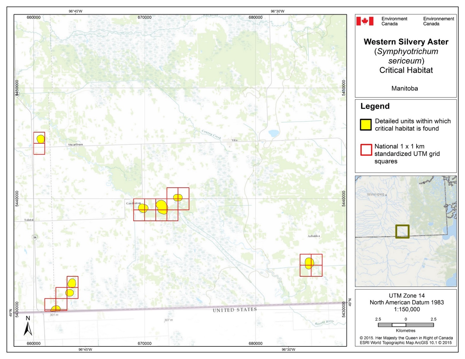
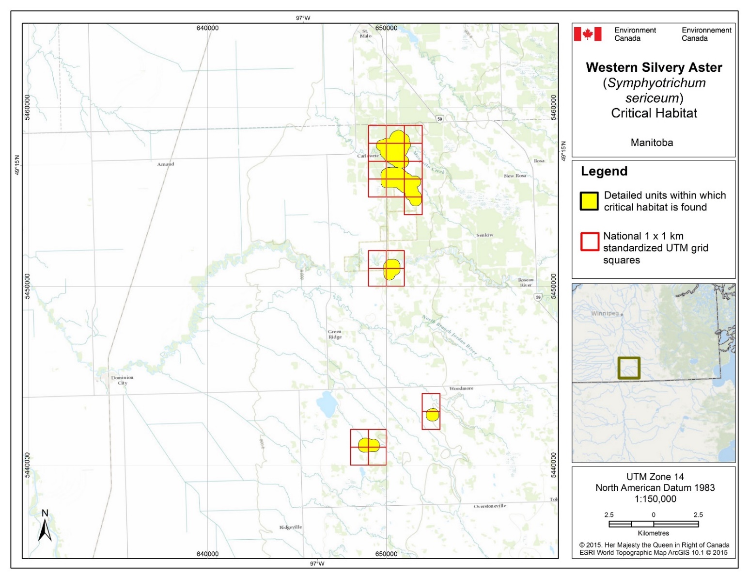
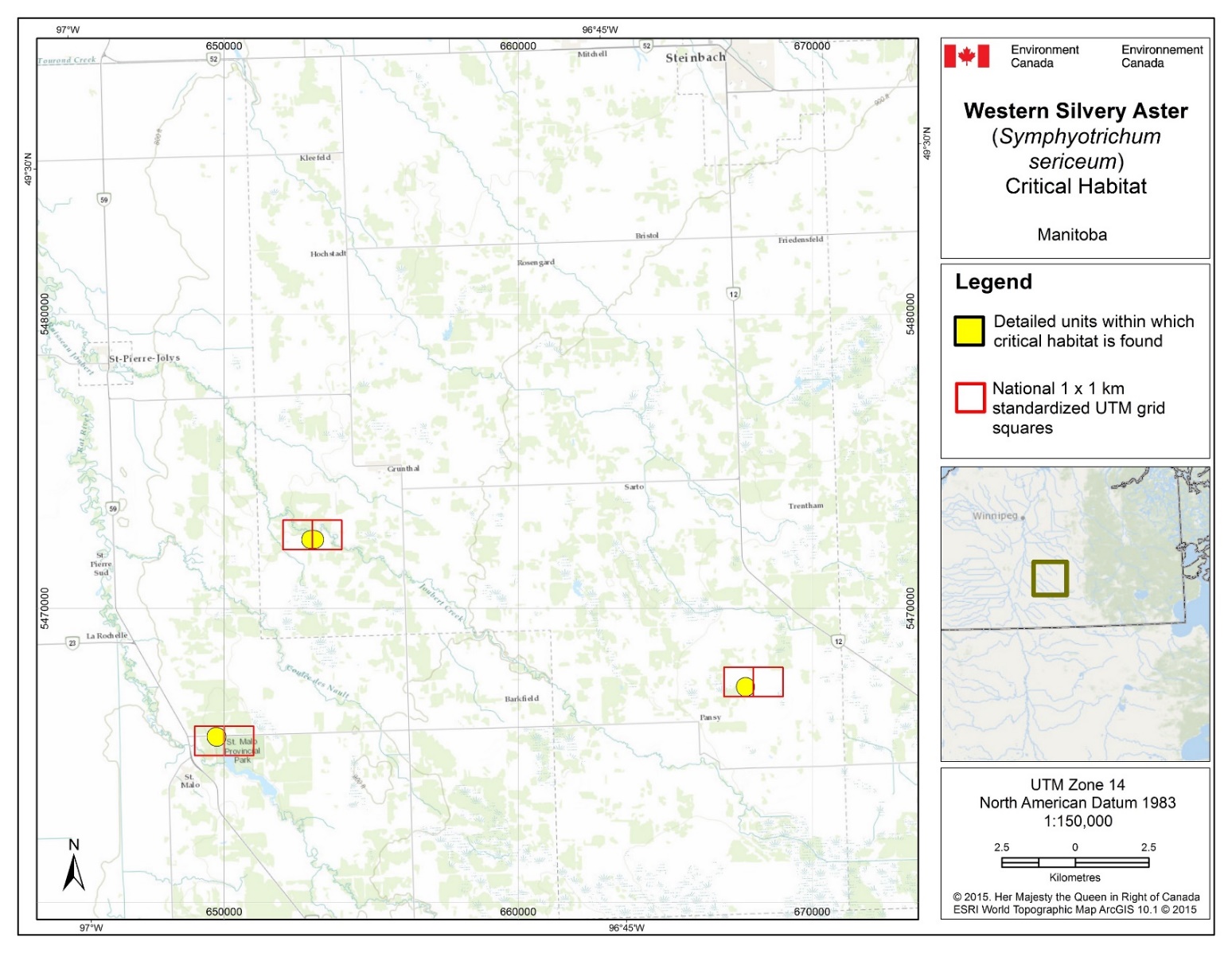
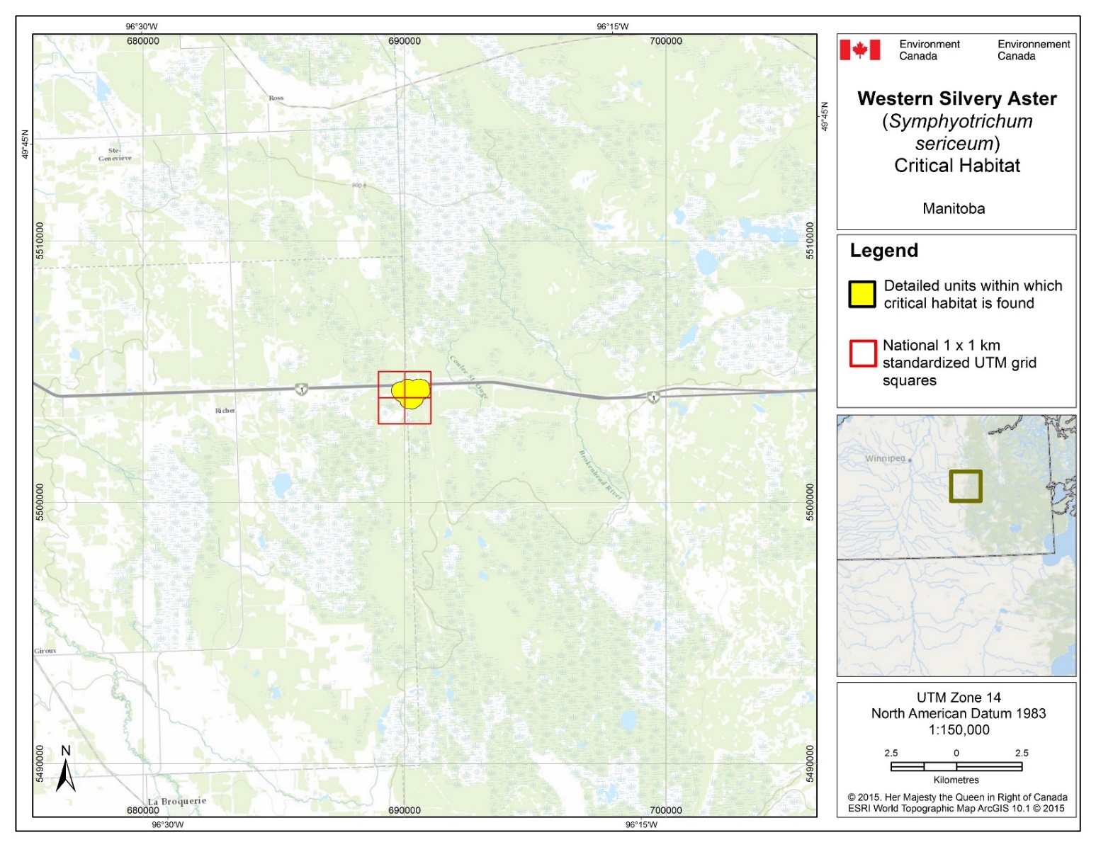
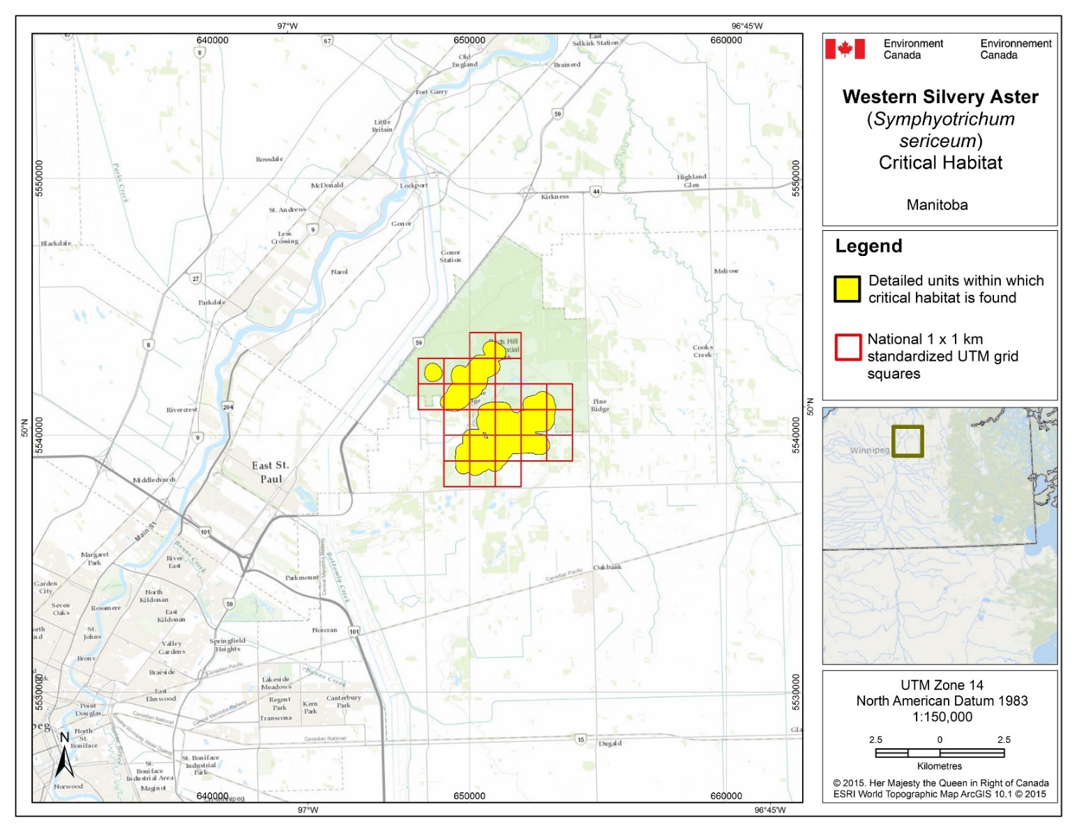
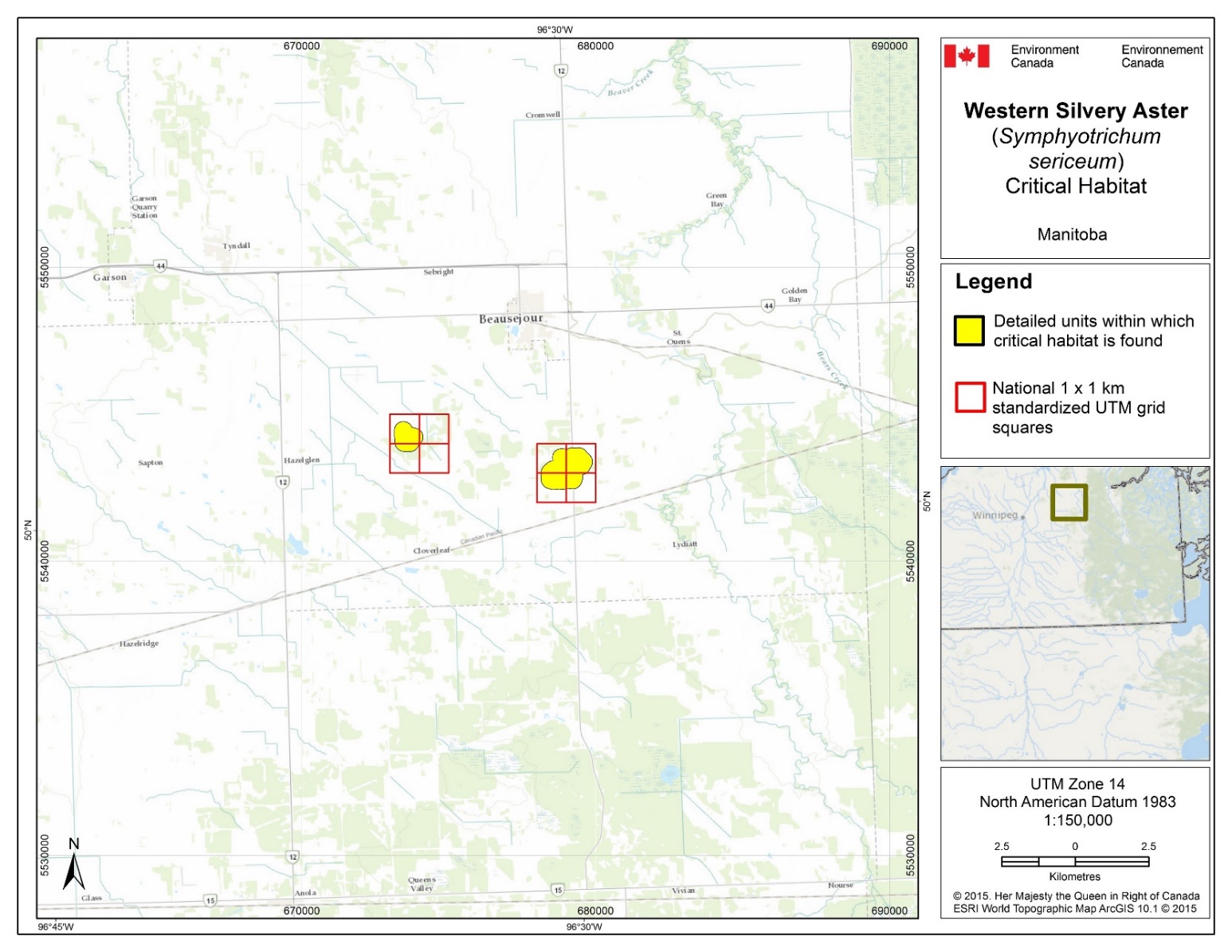
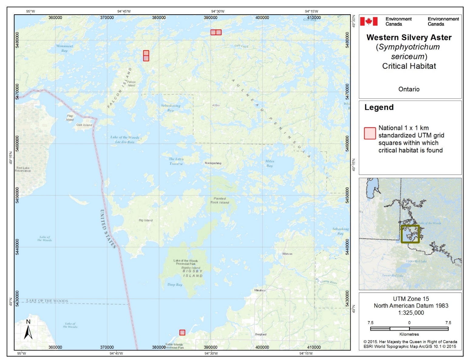
| Population Name [EO_ID] | 1 x 1 km Standardized UTM grid square IDa | Province/ Territory | UTM Grid Square Coordinates Eastingb | UTM Grid Square Coordinates Northingb | Critical Habitat Unit Area (ha)c |
|---|---|---|---|---|---|
| Bird’s Hill [2189] [2793] [3755] | 14UPA5318 | Manitoba | 651000 | 5538000 | 1149 |
| 14UPA5308 | Manitoba | 650000 | 5538000 | ||
| 14UPA4398 | Manitoba | 649000 | 5538000 | ||
| 14UPA5339 | Manitoba | 653000 | 5539000 | ||
| 14UPA5329 | Manitoba | 652000 | 5539000 | ||
| 14UPA5319 | Manitoba | 651000 | 5539000 | ||
| 14UPA5309 | Manitoba | 650000 | 5539000 | ||
| 14UPA4399 | Manitoba | 649000 | 5539000 | ||
| 14UPA5430 | Manitoba | 653000 | 5540000 | ||
| 14UPA5420 | Manitoba | 652000 | 5540000 | ||
| 14UPA5410 | Manitoba | 651000 | 5540000 | ||
| 14UPA5400 | Manitoba | 650000 | 5540000 | ||
| 14UPA4490 | Manitoba | 649000 | 5540000 | ||
| 14UPA5431 | Manitoba | 653000 | 5541000 | ||
| 14UPA5421 | Manitoba | 652000 | 5541000 | ||
| 14UPA5411 | Manitoba | 651000 | 5541000 | ||
| 14UPA5401 | Manitoba | 650000 | 5541000 | ||
| 14UPA4491 | Manitoba | 649000 | 5541000 | ||
| 14UPA4481 | Manitoba | 648000 | 5541000 | ||
| 14UPA5412 | Manitoba | 651000 | 5542000 | ||
| 14UPA5402 | Manitoba | 650000 | 5542000 | ||
| 14UPA4492 | Manitoba | 649000 | 5542000 | ||
| 14UPA4482 | Manitoba | 648000 | 5542000 | ||
| 14UPA5413 | Manitoba | 651000 | 5543000 | ||
| 14UPA5403 | Manitoba | 650000 | 5543000 | ||
| East Hazelglen [78] [4501] | 14UPA7492 | Manitoba | 679000 | 5542000 | 264 |
| 14UPA7482 | Manitoba | 678000 | 5542000 | ||
| 14UPA7493 | Manitoba | 679000 | 5543000 | ||
| 14UPA7483 | Manitoba | 678000 | 5543000 | ||
| 14UPA7443 | Manitoba | 674000 | 5543000 | ||
| 14UPA7433 | Manitoba | 673000 | 5543000 | ||
| 14UPA7444 | Manitoba | 674000 | 5544000 | ||
| 14UPA7434 | Manitoba | 673000 | 5544000 | ||
| Richer [4895] | 14UPA9003 | Manitoba | 690000 | 5503000 | 126 |
| 14UPA8093 | Manitoba | 689000 | 5503000 | ||
| 14UPA9004 | Manitoba | 690000 | 5504000 | ||
| 14UPA8094 | Manitoba | 689000 | 5504000 | ||
| N Pansy [3578] | 14UPV6687 | Manitoba | 668000 | 5467000 | 31 |
| 14UPV6677 | Manitoba | 667000 | 5467000 | ||
| Grunthal [1502] | 14UPV5732 | Manitoba | 653000 | 5472000 | 38 |
| 14UPV5722 | Manitoba | 652000 | 5472000 | ||
| Carlowrie [165] [3917] [4894] | 14UPV5605 | Manitoba | 650000 | 5465000 | 677 |
| 14UPV4695 | Manitoba | 649000 | 5465000 | ||
| 14UPV5514 | Manitoba | 651000 | 5454000 | ||
| 14UPV5515 | Manitoba | 651000 | 5455000 | ||
| 14UPV5505 | Manitoba | 650000 | 5455000 | ||
| 14UPV4595 | Manitoba | 649000 | 5455000 | ||
| 14UPV5516 | Manitoba | 651000 | 5456000 | ||
| 14UPV5506 | Manitoba | 650000 | 5456000 | ||
| 14UPV4596 | Manitoba | 649000 | 5456000 | ||
| 14UPV5517 | Manitoba | 651000 | 5457000 | ||
| 14UPV5507 | Manitoba | 650000 | 5457000 | ||
| 14UPV4597 | Manitoba | 649000 | 5457000 | ||
| 14UPV5518 | Manitoba | 651000 | 5458000 | ||
| 14UPV5508 | Manitoba | 650000 | 5458000 | ||
| 14UPV4598 | Manitoba | 649000 | 5458000 | ||
| 14UPV5500 | Manitoba | 650000 | 5450000 | ||
| 14UPV4590 | Manitoba | 649000 | 5450000 | ||
| 14UPV5501 | Manitoba | 650000 | 5451000 | ||
| 14UPV4591 | Manitoba | 649000 | 5451000 | ||
| Woodmore [5188] [5189] [7576] | 14UPV4490 | Manitoba | 649000 | 5440000 | 160 |
| 14UPV4480 | Manitoba | 648000 | 5440000 | ||
| 14UPV4491 | Manitoba | 649000 | 5441000 | ||
| 14UPV4481 | Manitoba | 648000 | 5441000 | ||
| 14UPV5422 | Manitoba | 652000 | 5442000 | ||
| 14UPV5423 | Manitoba | 652000 | 5443000 | ||
| 14UPV6404 | Manitoba | 660000 | 5444000 | ||
| 14UPV6405 | Manitoba | 660000 | 5445000 | ||
| E Gardenton [5210] | 14UPV8353 | Manitoba | 685000 | 5433000 | 65 |
| 14UPV8343 | Manitoba | 684000 | 5433000 | ||
| 14UPV8354 | Manitoba | 685000 | 5434000 | ||
| 14UPV8344 | Manitoba | 684000 | 5434000 | ||
| N Gardenton [744] [984] [4893] | 14UPV7328 | Manitoba | 672000 | 5438000 | 196 |
| 14UPV7318 | Manitoba | 671000 | 5438000 | ||
| 14UPV7308 | Manitoba | 670000 | 5438000 | ||
| 14UPV6398 | Manitoba | 669000 | 5438000 | ||
| 14UPV7339 | Manitoba | 673000 | 5439000 | ||
| 14UPV7329 | Manitoba | 672000 | 5439000 | ||
| 14UPV7319 | Manitoba | 671000 | 5439000 | ||
| 14UPV7309 | Manitoba | 670000 | 5439000 | ||
| 14UPV6399 | Manitoba | 669000 | 5439000 | ||
| 14UPV7430 | Manitoba | 673000 | 5440000 | ||
| 14UPV7420 | Manitoba | 672000 | 5440000 | ||
| W Gardenton [1270] [3242] | 14UPV6320 | Manitoba | 662000 | 5430000 | 120 |
| 14UPV6310 | Manitoba | 661000 | 5430000 | ||
| 14UPV6331 | Manitoba | 663000 | 5431000 | ||
| 14UPV6321 | Manitoba | 662000 | 5431000 | ||
| 14UPV6332 | Manitoba | 663000 | 5432000 | ||
| 14UPV6219 | Manitoba | 661000 | 5429000 | ||
| 14UPV6229 | Manitoba | 662000 | 5429000 | ||
| Cliff Island | 15UUQ9811 | Ontario | 391000 | 5481000 | 9 |
| 15UUQ9801 | Ontario | 390000 | 5481000 | ||
| French Portage Narrows | 15UUQ7777 | Ontario | 377000 | 5477000 | 3 |
| 15UUQ7776 | Ontario | 377000 | 5476000 | ||
| Big Traverse Bay (Budreau’s Beach) | 15UUQ8243 | Ontario | 384000 | 5423000 | 2 |
a Based on the standard UTM Military Grid Reference System, where the first 2 digits and letter refer to the UTM zone, the following 2 letters indicate the 100 x 100 km Standardized UTM grid followed by 2 digits to represent the 10 x 10 km Standardized UTM grid. The last 2 digits represent the 1 x 1 km Standardized UTM grid containing all or a portion of the critical habitat unit. This unique alphanumeric code is based on the methodology produced from the Breeding Bird Atlases of Canada.
b The listed coordinates are a cartographic representation of where critical habitat can be found, presented as the southwest corner of the 1 x 1 km Standardized UTM grid square containing all or a portion of the critical habitat unit. The coordinates are provided as a general location only in NAD 1983 UTM.
c The area presented is that of the unit(s) containing critical habitat (rounded to the nearest 1ha); therefore, the actual area of critical habitat may be significantly less. Refer to Section 7.1 for a description of how critical habitat within these areas is defined.
Appendix C: Effects on the Environment and Other Species
A strategic environmental assessment (SEA) is conducted on all SARA recovery planning documents, in accordance with the Cabinet Directive on the Environmental Assessment of Policy, Plan and Program Proposals. The purpose of a strategic environmental assessment is to incorporate environmental considerations into the development of public policies, plans, and program proposals to support environmentally sound decision-making and to evaluate whether the outcomes of a recovery planning document could affect any component of the environment or any of the Federal Sustainable Development Strategy’s (FSDS) goals and targets.
Recovery planning is intended to benefit species at risk and biodiversity in general. However, it is recognized that strategies may also inadvertently lead to environmental effects beyond the intended benefits. The planning process based on national guidelines directly incorporates consideration of all environmental effects, with a particular focus on possible impacts upon non-target species or habitats. The results of the SEA are incorporated directly into the strategy itself, but are also summarized below in this statement.
Many federal species at risk are found in habitat occupied by Western Silvery Aster (Table C1), as well as provincially rare species. Most, if not all, of these species will benefit from recovery activities and management of threats intended to maintain habitat for the benefit of Western Silvery Aster.
The potential for the recovery strategy to inadvertently lead to adverse effects on other species was considered. Broad approaches to recovery for the Western Silvery Aster include habitat protection, stewardship, and habitat management activities (such as prescribed burns, invasive species control, and brush removal). These activities are aimed at maintaining or improving provincially rare habitats such as tall-grass prairie fragments and Bur Oak savannah. For the most part, managing for healthy native ecosystems will benefit non-target species, natural communities, or ecological processes. As a general rule, management actions that incorporate or mimic natural disturbance regimes (e.g., fire and grazing) are natural components of prairie ecosystems and are not likely to negatively impact the persistence of other native species particularly if the timing, intensity and frequency mimic those natural processes (Samson and Knopf 1994). However, some management practices, including prescribed burns, mowing or grazing, and some forms of integrated weed management, have the potential to affect other species negatively in the short or long-term. Dakota Skipper (Hesperia dacotae), Western Silvery Aster and Rough Agalinis (Agalinis aspera), for example, can be negatively affected by mowing if done in late summer/fall whereas Small White Lady’s-slipper (Cypripedium candidum) can be harmed if the area is mowed in spring/early summer (Environment Canada 2014a, MB Conservation unpublished management summaries). Therefore, it is important that management actions resulting from recovery strategies, action plans and beneficial management plans are developed from an ecosystem perspective (including development of multi species action plans and ecosystem beneficial management plans), incorporating as many species needs as possible, and evaluating the ecological risks of any action, in order to reduce any possible negative effects to other species. An ongoing monitoring program should also be in place to evaluate short and long term effects of management actions on the ecosystem and individual species at risk. Efforts should be coordinated with recovery teams and organizations working in the tall-grass prairie ecosystem to ensure the most efficient use of resources and to prevent duplication of effort or conflicts with research.
The SEA concluded that this strategy will not entail significant adverse effects. For further details see the following sections: 3.3 Needs of the Western Silvery Aster, 4. Threats, and 6. Broad strategies and general approaches to meet objectives.
| Common name | Scientific name | SARA designation | Province |
|---|---|---|---|
| Rough Agalinis | Agalinis aspera | END | MB |
| Gattinger’s Agalinis | Agalinis gattingeri | END | MB |
| Small White Lady’s Slipper | Cypripedum candidum | END | MB |
| Western Prairie Fringed Orchid | Platanthera praeclara | END | MB |
| Riddell’s Goldenrod | Oligoneuron riddellii | SC | MB |
| Dakota Skipper | Hesperia dacotae | END | SK, MB |
| Poweshiek Skipperling | Oarisma poweshiek | THR | MB |
| Monarch | Danaus plexippus | SC | BC, AB, SK, MB, ON, QC, NB, PEI, NS |
| Yellow Rail | Coturnicops noveboracensis | SC | NWT, BC, AB, SK, MB, QC, NB |
Appendix D: Some Potentially Beneficial Management Practices
Western Silvery Aster occupies habitat varying in ecology, land use history, and land tenure, as well as occupying habitat containing other species at risk (Appendix C). For these reasons, it is difficult to propose a general beneficial management plan that would be appropriate to encompass all habitat and needs. Instead, specific recommendations will be made in one or more action plans or beneficial management plans at scales appropriate for the habitat, land use, suite of species, and application. Any management undertaken will require baseline data on habitat and species at risk populations, followed up by regular monitoring so that adaptive management practices can occur and knowledge gaps on impacts of threats and management practices can be answered. At this time only a few general statements can be made regarding on going activities that should benefit Western Silvery Aster.
Careful and deliberate application of grazing by one or more classes of livestock may help maintain open and slightly disturbed prairie habitat needed by Western Silvery Aster. Management of these livestock requires occasional and randomly dispersed overland access on foot, on-horseback, by all-terrain vehicle
Integrated weed management to control invasive alien species and management to control encroachment of woody vegetation could directly reduce competition with Western Silvery Aster. Approaches used to reduce the occurrence and density of invasive alien species or woody vegetation in Western Silvery Aster habitat need to be dealt with on a site specific basis through consultation with experts or in one or more action plans; monitoring of the population response to any management action is necessary.
Fires resulting from accidental or deliberate ignition by people will not destroy Western Silvery Aster habitat nor harm individual plants under most circumstances. In fact, prescribed burns that are carefully managed and that mimic the timing, frequency and intensity of natural processes may improve habitat by reducing or preventing invasion of woody vegetation, invasive alien species, grass litter, insect pests and pathogens. Co occurring species that may be negatively affected by prescribed burning should be considered (Appendix C).
Environment and Climate Change Canada will work with all of its partners to define and improve best practices for conserving the Western Silvery Aster across its range and to incorporate multi species requirements and management practices.
Footnotes
- footnote[1] Back to paragraph Species at risk: the act, the accord and the funding programs
- footnote[2] Back to paragraph These federally protected areas are: a national park of Canada named and described in Schedule 1 to the Canada National Parks Act, The Rouge National Park established by the Rouge National Urban Park Act, a marine protected area under the Oceans Act, a migratory bird sanctuary under the Migratory Birds Convention Act, 1994 or a national wildlife area under the Canada Wildlife Act see ss. 58(2) of SARA.
- footnote[3] Back to paragraph Rank 1– critically imperiled; 2– imperiled; 3– vulnerable to extirpation or extinction; 4– apparently secure; 5– secure; H– possibly extirpated; SNR – status not ranked; ? – inexact or uncertain and qualifies the character immediately before it (NatureServe 2015c).
- footnote[4] Back to paragraph Extant means the occurrence has been recently verified as still existing, information on the location is accurate, and habitat still exists at the time of writing the recovery strategy (NatureServe 2015c).
- footnote[5] Back to paragraph Each population is composed of one or more occurrences and for the purposes of the recovery strategy will be equivalent to an element occurrence as defined by NatureServe (2015a).
- footnote[6] Back to paragraph Extirpated either means that conditions or habitat no longer exist at an occurrence to support the species, or sufficient surveys have taken place at the occurrence over an adequate time period and during good growing years, conducted by experienced surveyors, yet failed to relocate the species at the occurrence (NatureServe 2015c).
- footnote[7] Back to paragraph Upland Bur Oak vegetation type (V3.3) as described in the Forest Ecosystem Classification for Northwestern Ontario (Sims et al. 1997).
- footnote[a] Back to paragraph Threat # - Threats are numbered using the IUCN Classification System. Only those threats relevant to Western Silvery Aster are presented in this table and in Section 4.2 Description of Threats.
- footnote[b] Back to paragraph Impact – The degree to which a species is observed, inferred, or suspected to be directly or indirectly threatened in the area of interest. The impact of each threat is based on Severity and Scope rating and considers only present and future threats. Threat impact reflects a reduction of a species population or decline/degradation of the area of an ecosystem. The median rate of population reduction or area decline for each combination of scope and severity corresponds to the following classes of threat impact: Very High (75% declines), High (40%), Medium (15%), and Low (3%). Unknown: used when impact cannot be determined (e.g., if values for either scope or severity are unknown); Not Calculated: impact not calculated as threat is outside the assessment timeframe (e.g., timing is insignificant/negligible or low as threat is only considered to be in the past); Negligible: when scope or severity is negligible; Not a Threat: when severity is scored as neutral or potential benefit.
- footnote[c] Back to paragraph Scope – Proportion of the species that can reasonably be expected to be affected by the threat within 10 years. Usually measured as a proportion of the species’ population in the area of interest. (Pervasive = 71–100%; Large = 31–70%; Restricted = 11–30%; Small = 1–10%; Negligible < 1%).
- footnote[d] Back to paragraph Severity – Within the scope, the level of damage to the species from the threat that can reasonably be expected to be affected by the threat within a 10 year or three-generation timeframe. Usually measured as the degree of reduction of the species’ population. (Extreme = 71–100%; Serious = 31–70%; Moderate = 11–30%; Slight = 1–10%; Negligible < 1%; Neutral or Potential Benefit ≥ 0%).
- footnote[e] Back to paragraph Timing – High = continuing; Moderate = only in the future (could happen in the short term [< 10 years or 3 generations]) or now suspended (could come back in the short term); Low = only in the future (could happen in the long term) or now suspended (could come back in the long term); Insignificant/Negligible = only in the past and unlikely to return, or no direct effect but limiting.
- footnote[8] Back to paragraph Occurrences that are considered historic are excluded from these objectives until such time as they are reconfirmed.
- footnote[9] Back to paragraph Habitat where no active management is occurring.
- footnote[10] Back to paragraph Western Silvery Aster occurrences known to Environment Canada as of September 2013 (for Manitoba populations) and January 2015 (for Ontario populations). Data was obtained from the Manitoba Conservation Data Center, the Ontario Conservation Data Center (Natural Heritage Information Center), and the Ontario Ministry of Natural Resources and Forestry.
- footnote[11] Back to paragraph Suitable habitat patches were delineated ex-situ using the best available satellite imagery (World View 01 and World View 02 imagery (0.5m) at 1:500 map scale, SPOT5 Panchromatic imagery (2.5m) at 1:2500 map scale, and IKONOS and NAIP imagery (1.0m) at 1:1000 map scale) following concepts of object-based segmentation (Jobin et al. 2008). Suitable habitat patches were identified based on vegetation community type using colour and texture. For a description of suitable habitat refer to Section 3.3 of this document.
- footnote[12] Back to paragraph Biophysical attributes include, but are not limited to, soils and bedrock geology, surface and sub surface hydrology, vegetation and vegetation community composition, and landforms. Rivers, lakes, and wetlands are exempt from this definition and are therefore not considered critical habitat.
- footnote[13] Back to paragraph Suitable habitat is considered the Upland Bur Oak (v3.3 vegetation type) vegetation type and was delineated and identified based on biophysical attributes of vegetation community type, soils, and moisture by the FEC framework for Northwestern Ontario.
- footnote[14] Back to paragraph Values and populations in the table are those known to Environment Canada as of September 2013 (for Manitoba populations) and January 2015 (for Ontario populations), and were obtained from the Manitoba Conservation Data Center, the Ontario Conservation Data Center (Natural Heritage Information Center), and the Ontario Ministry of Natural Resources and Forestry.
- footnote[15] Back to paragraph Populations are defined as an element occurrence (EO) based on the Natureserve (2015a) habitat-based plant delimitation guidance.
- footnote[22] Back to paragraph This applies to the management practices in rangelands only and does not include recreational use of all-terrain vehicles in other areas.