Wheatley Provincial Park Management Plan
This document provides policy direction for the protection, development and management of Wheatley Provincial Park and its resources.
Approval statement
Wheatley Provincial Park is set in wooded surroundings, representative of a former forested landsca pe of extreme southwestern Ontario, and is located on the north shore of Lake Erie. A recreation class provincial park, Wheatley offers a wide variety of outdoor activities to a clientele that enjoys this park as a vacation destination.
We are pleased to approve the Wheatley Provincial Park Management Plan as official policy for the management and development of this park. The plan reflects this Ministry’s intent to protect natural features of Wheatley Provincial Park and to maintain high quality opportunities for outdoor recreation and heritage appreciation for both residents of Ontario and visitors to the province.
David Johnstone
Regional Director
Southwestern Region
Norm R. Richards
Director
Parks and Recreational Areas Branch
1.0 Introduction
Wheatley Provincial Park is situated in extreme southwestern Ontario on the north shore of Lake Erie, about one kilometre east of the village of Wheatley (Figure 1). The park was established in 1971 by Regulation 114/71 under the Provincial Parks Act, with an area of 241 hectares.
Windsor and Chatham are within a one hour drive of the park. Metropolitan Detroit is also at a convenient driving distance, and consequently about 30 per cent of the park’s campers are residents of the United States. In 1986 approximately 61,000 visitors enjoyed the park’s 210 campsites and two kilometres of beach. A number of nearby attractions, including Point Pelee National Park and Jack Miner’s Sanctuary, contribute to Wheatley Provincial Park’s popularity as a vacation destination.
Due to the southerly location of the park and the moderating climatic influence of Lake Erie, the natural vegetation is similar to that found farther south. A number of plants are near the northern limits of their ranges and several species are considered rare in Ontario. This vegetation is particularly well represented in the park’s major woodlot, the Ern Wigle Tract (see Section 5.2).
2.0 Classification
Wheatley is classified as a Recreational Park in recognition of its ability to support a wide variety of outdoor recreational activities in an attractive setting.
3.0 Goal
The goal for Wheatley Provincial Park is to provide a variety of outdoor recreational opportunities and to protect provincially significant natural environments.
4.0 Objectives
Wheatley Provincial Park will contribute to the achievements of the Ministry of Natural Resources’ Chatham District Land Use Guidelines and the objectives for Ontario’s Provincial Park system in the following manner.
4.1 Protection
To protect provincially significant elements of the natural and cultural landscape of Ontario.
The natural environment of the park is representative of a landscape once common in extreme southwestern Ontario and, as such, incorporates provincially significant life science features. These features will be protected by appropriate zoning and management (see Section 5.2 for details). Should any significant archaeological sites be discovered, appropriate protective measures will be taken.
4.2 Recreation
To provide outdoor recreation opportunities ranging from high intensity day use to low intensity wilderness experiences.
Wheatley Provincial Park helps meet the need for high intensity recreation opportunities by providing approximately 26,000 camping opportunities and 84,000 day-use opportunities annually. The facilities that provide these opportunities include: 210 campsites served by comfort stations with showers; a group camping area; and a day-use area containing two kilometres of beach, a picnic area, two picnic shelters, and two comfort stations.
Wheatley Provincial Park’s contribution to the recreation targets as set out in the Chatham District Land Use Guidelines (C.D.L.U.G.) are as follows:
| C.D.L.U.G. Target |
Park Contribution | |
|---|---|---|
| Camping Opportunities | 415,000 | 26,000 |
| Campsites | 1,781 | 210 |
| Picnic Tables | 2,251 | 550 |
| Day-Use Opportunities | 3,926,500 | 84,000 |
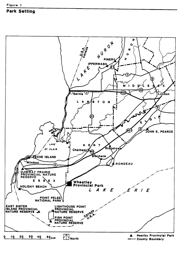
Enlarge this park setting map for Wheatley Provincial Park (PDF)
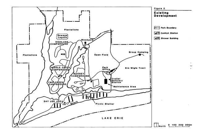
Enlarge this existing development map for Wheately Provincial Park (PDF)
4.3 Heritage appreciation
To provide opportunities for exploration and appreciation of the outdoor natural and cultural heritage of Ontario.
Appreciation and understanding of the park’s Carolinian vegetation will be enhanced through an interpretive program (see Section 7.1). Walking paths will offer visitors the opportunity to view natural features firsthand.
A preliminary archaeological survey stated that there were no significant sites in the park. Therefore, no special archaeological interpretation or protection will be undertaken.
4.4 Tourism
To provide Ontario residents and out-of-province visitors with opportunities to discover and experience the distinctive regions of the province.
The park will provide day-use and camping opportunities to visitors attracted from considerable distances. The local area offers many attractions such as Point Pelee National Park, Wheatley Harbour (the largest freshwater fishing port in the world), Jack Miner’s Sanctuary, the Pelee Island Ferry, bird watching and a valued agricultural industry. Interest in these attractions will be encouraged by providing park visitors with appropriate promotional material.
By annually serving over 60,000 visitors from Canada and the United States, Wheatley Provincial Park makes a valuable contribution to the local and provincial economies. This contribution will be maintained and enhanced through effective management and marketing.
5.0 Zoning
Three types of zones will be designated to guide the management of the Park: development, nature reserve, and natural environment (see Figure 3).
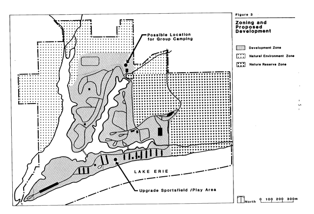
Enlarge this zoning and proposed development map for Wheately Provincial Park (PDF)
5.1 Development zone (71 hectares)
This zone will encompass all developed areas including four campgrounds, the day-use area, roads and associated administration-maintenance facilities. Management will be directed at providing high quality camping and day-use opportunities in an attractive outdoor setting.
5.2 Nature reserve zone (46 hectares)
Wheatley Provincial Park is in the Carolinian Floristic Zone of the Eastern Deciduous Forest Region (Hill’s Site District 7-1). The vegetation bears similarities to that farther south. Consequently a number of species, including chestnut, sassafras, black gum and pin oak, are near the northern limit of their ranges. These species, and several other rare species, are well-represented in the Ern Wigle Tract, at the park’s eastern edge. This area features one of the finest stands of black gum in the province.
Adjacent to the Ern Wigle Tract is an open field that hosts a number of plant species normally associated with prairie habitats. These species, and the plant communities of which they are part, are considered significant.
These two areas will be incorporated into a nature reserve zone, in which management will be directed at protecting representative and significant natural features described above. Natural succession will be allowed to occur, unless the need to manage individual species or communities is established, in which case specific measures will be incorporated into the park’s vegetation management plan (see Sections 6.2 and 8.0).
The interpretive trail located in the Ern Wigle Tract will be retained. Relocation will be undertaken if necessary to protect natural features (see Section 9.4).
The group camping area will be relocated outside the nature reserve zone (see Section 9.1). In the meantime group camping will be treated as a non-conforming interim use within the nature reserve zone, and the site will be monitored to determine if unacceptable impacts to natural features occur.
5.3 Natural environment zone (124 hectares)
The remaining area of the park will be designated as a natural environment zone, which will include landscape with some natural features where minimal development is required to support low intensity recreational activities. This zone will also serve as a buffer area between the development zone and adjacent private land.
The natural environment zone is comprised of conifer plantations, a study plot (picetum), wetlands, an open field complex, the waters of the creek system and a 26 hectare water lot in Lake Erie.
Approximately 80,000 trees of assorted species were planted in the natural environment zone between 1965 and 1980, with the majority being established in plantations on the west and northwest sections of the park. Scotch pine, spruce and white pine, the major species in the plantations, will be managed with the long term objective being to revert the plantations to more natural plant communities.
The picetum is a 0.5 hectare experimental spruce plantation managed by the Great Lakes Forest Research Centre. It was established for long-term research in 1969 and this use will be continued.
6.0 Resource management policies
The park will be managed in accordance with the general planning and management policies for recreational class provincial parks. Where needed, additional direction to meet requirements specific to Wheatley Provincial Park is provided in this section.
6.1 Land and water
To ensure public health and safety, water quality in bathing areas will be monitored by the Ministry of Natural Resources in accordance with an approved testing procedure. Samples from the creeks indicate that these waters normally have high bacterial counts. Consequently, the creeks cannot be used for swimming.
The shoreline area of the park is eroding, as is much of the entire northern shore of Lake Erie. Fluctuating lake water levels affect the erosion rate significantly, with the average rate at Wheatley being 0.5 metres/year. No erosion protection measures will be undertaken at this time. The rate of erosion will be monitored; should park facilities be threatened, then protective measures will be considered based on a study of environmental, aesthetic, recreational and economic factors.
Creek banks are continually being eroded due to pedestrian traffic and a large population of carp that causes turbulence and prevents the establishment of vegetation. Trails will be located a short distance away from the creek banks to allow vegetation to become re-established. The carp population will continue to control itself naturally.
6.2 Vegetation
Vegetation in the park will be managed to achieve the protection and recreation objectives of- this plan. The removal of vegetation will be permitted only where there is a threat to human safety and/or property, or where it is necessary to meet resource management objectives of the vegetation management plan.
Existing plantations in the natural environment zone will be managed to accelerate their conversion to hardwood forest. To provide shade in open areas and screening between campsites, tree planting will continue in campgrounds and day-use areas. Only native species will be planted.
A vegetation management plan will direct the measures described above and those mentioned previously (Sections 4.1 and 5.2).
6.3 Fisheries
Sport fishing is permitted in the creeks and in Lake Erie, but no fisheries management plan is required. Bow hunting for carp will not be allowed.
6.4 Wildlife
Native wildlife shrubs have been planted in development zones to create wildlife corridors and provide winter food. This practice will be continued. Hunting will not be permitted.
A wildlife management plan will be prepared if a need is demonstrated, otherwise the needs of wildlife will be met through the vegetation management plan.
Nuisance animals will be removed or destroyed under the direction of Ministry of Natural Resources staff.
7.0 Operations policies
7.1 Visitor Services
7.1.1. Communications
The park will play a role in the encouragement of local and provincial tourism by making appropriate promotional literature and information about local events available at the park office. Information about emergency services will be available at all times. Schedules for park events will be posted at the office and at comfort stations.
7.1.2 Interpretation
The theme of the interpretive program will be the park’s Carolinian vegetation, including its ecology and its heritage value. Publications, displays, personal contact with staff, and self-guided nature trails will be the primary means of communicating interpretive messages. Limited programs may be undertaken by staff.
7.1.3 Recreation
In recognition of the park’s recreation class designation, recreation programs, such as sing-alongs and group activities, may be organized by staff. Self-directed activities will be encouraged by making sports equipment available, and by providing suitable facilities, such as a playground. Interpretive and recreation programs will be guided by a visitor services plan.
7.2 Research
The park offers opportunities for research into the ecology of Carolinian vegetation communities and associated significant species. Research will be permitted subject to provincial parks policies. Research into the ecology of black gum stands will be encouraged to determine if active management is required to perpetuate the species.
7.3 Marketing
Between 1981 and 1986 the total annual number of visitors to the park grew by 12 per cent, and the July-August campground occupancy rate increased to 47 per cent from 42 per cent. A trend towards more family camping has been apparent. Based on analysis of visitor data, a marketing plan has been developed to encourage additional park visitation by directing where and how a marketing effort should be aimed.
7.4 Emergency services
A park emergency plan provides staff with instructions for emergency situations. This plan will be reviewed annually and updated as required.
7.5 Law enforcement
The enforcement program will be carried out according to Ministry of Natural Resources’ policy and the Chatham District Operations Law Enforcement Plan to provide for the safety and security of park users and facilities.
7.6 Park concession
Park concession agreements will continue to be encouraged as a means to provide users with a wide variety of recreational activities. A watercraft concession exists at present. User surveys will determine the need for additional concessions such as bicycle rentals.
8.0 Development
Any future development will proceed in accordance with this management plan and provincial park standards. Detailed site plans will be completed and approved in advance of the development of new facilities. Development projects will be phased according to Section 9.0 and as funding permits.
8.1 Camping areas
The 210 existing campsites will be retained and approximately 50 will be supplied with electrical outlets to better serve park visitors and encourage use of the lightly used Highlands and Middle Creek campgrounds.
An additional 10 to 15 campsites will be constructed in the existing campgrounds along the creek system, provided that pre-construction inspection by a qualified life scientist determines their construction will not have unacceptable impacts on any significant flora or fauna. Minor alterations may be made to the existing road system to accommodate these new sites.
The group campground now located in the Ern Wigle Tract will be relocated to prevent long-term environmental damage (see Section 5.2). A likely alternative location is north of the Highland Campground, where plantations now exist.
8.2 Roads
All main park roads will be hard-surfaced to increase visitor satisfaction and reduce maintenance costs. Dust control will be used on secondary roads.
8.3 Service systems
Comfort stations and vault privies, along with the related systems such as the trailer sanitation station, pumping stations, sewer lines and sewage lagoon, will be maintained and upgraded as required. Installation of improved walkways and landscaping around comfort stations may be carried out.
The village of Wheatley’s municipal water system provides water to the park system. This system will be maintained and upgraded as required. Fire hydrant locations will be assessed and surplus hydrants removed.
8.4 Trails
A self-guided interpretive trail has been developed in the Ern Wigle Tract to encourage understanding of the Carolinian vegetation. The trail will be monitored to ensure that significant features are protected. If necessary the trail will be relocated to protect such features.
8.5 Beach and picnicking area
The Lake Erie shore provides a beach suitable for swimming and sunbathing. A low bluff separates the beach from the picnicking area, where picnic tables, parking areas, a fitness trail, barbecues, picnic shelters, play areas and comfort stations are provided. Stairways facilitate access to the beach; more stairways will be installed if necessary. Two footbridges give campers easy access to the beach and these will be maintained. Improvements will be made to the sports field/play area to make the day use area more attractive, particularly to groups.
9.0 Implementation strategy
The management plan will be reviewed at least once every ten years or as the need arises. Data collection and resource monitoring will be conducted on an ongoing basis to further increase the ministry’s ability to effectively and efficiently achieve park objectives.
Actions required to implement this plan are listed below. The schedule for completion of the projects will be governed by the availability of capital and operational funding.
The activities required include but are not limited to the following, in order of priority:
- Hard surfacing all main roads;
- Landscaping around comfort stations;
- Converting approximately 50 campsites to electrical sites;
- Upgrading sports field/play area in day-use area;
- Preparing a vegetation management plan;
- Construct 10-15 creek front campsites;
- Monitoring shoreline erosion;
- Relocating the group camping area;
10.0 Summary of public consultation
From 1977 to 1988 Wheatley Provincial Park was operated under the direction of interim management guidelines. In 1981 the park management planning process was initiated when a news release was issued inviting public input regarding the future of the park. Based upon comments received, work on this management plan was started in 1984.
Selected references
Klinkenberg, R. 1985. Life Science Areas of Natural and Scientific Interest in Site District 7-1: A Review and Assessment of Significant Natural Areas. Parks and Recreational Areas Section, Ministry of Natural Resources, Southwestern Region. 82 pp.
Klinkenberg, R. and J. Edwards. 1980. A Preliminary Life Science Inventory of Wheatley Provincial Park. Chatham District, Ministry of Natural Resources. 56 pp.
Lindsay, K. M. 1982. Rare Vascular Plants of Twelve Provincial Parks in the Decidious Forest Region of Southern Ontario. Ontario Field Biologist 36(2):53-70.
Ontario Ministry of Natural Resources. 1974. Visitor Services Plan, Southwestern Region Provincial Parks, O.M.N.R. London.
Ontario Ministry of Natural Resources. 1977. Interim Management Guidelines for Wheatley Provincial Park. O.M.N.R. Chatham. 37 pp.
Ontario Ministry of Natural Resources. 1978. Ontario Provincial Parks Planning and Management Guidelines. O.M.N.R., Parks Planning Section, Toronto.
Ontario Ministry of Natural Resources 1983. Chatham District Land Use Guidelines. O.M.N.R. Chatham. 61 pp.
Stothers, D.M. 1972. A Preliminary Report of the Archaeological Survey of Wheatley Provincial Park. Ministry of Natural Resources. 7 pp.
3320
(0.3k P.R. 87.03.12) ISBN 0-7729-0290-9
Footnotes
- footnote[1] Back to paragraph The C.D.L.U.G. was completed in 1983 and include opportunities and facilities offered by Pinery and Ipperwash Provincial Parks.