Whitefish River Sandy Till Conservation Reserve Management Statement
This document provides policy direction for the protection, development and management of the Whitefish River Sandy Till Conservation Reserve and its resources.
November 2004
Kirkland Lake District
Ministry of Natural Resources
Approval statement
I am pleased to approve this Statement of Conservation Interest (SCI) for the Whitefish River Sandy Till Conservation Reserve.
Direction for establishing, planning and managing conservation reserves is defined under the Public Lands Act and current policy. “Ontario’s network of natural heritage areas has been established to protect and conserve areas representative of the diversity of the natural regions of the province, including species, habitats, features, and ecological systems which comprise that natural diversity.” (Policy 3.03.05, MNR 1997). The specific direction for managing this Conservation Reserve is in the form of a basic SCI, which defines the area to which the plan applies, provides the purpose for which the Conservation Reserve has been proposed, and outlines the Ministry of Natural Resources’ management intent for the protected area. This SCI has been created with input from program specialists within the Kirkland Lake District.
This SCI will provide guidance for the management of the conservation reserve and the basis for the ongoing monitoring of activities. More detailed direction at this time is not anticipated. Should significant facility development be considered, or complex issues arise requiring additional studies, more defined management direction, or special protection measures, a more detailed Conservation Reserve Management Plan will be prepared with full public consultation.
The public was consulted on this site prior to its regulation during the planning for Ontario’s Living Legacy (MNR, 1999). Furthermore, the public was notified during a 30 day period commencing November 30, 2004 concerning a draft of this SCI. Comments from the notification period have been considered in the development of this document.
The conservation reserve will be managed under the jurisdiction of the Elk Lake - Matheson Area Supervisor of the Ministry of Natural Resources, Kirkland Lake District.
Plan Author:
Jessica Malone, Land Use Planning Intern
Kirkland Lake District
Approved by:
Corrine Nelson, District Manager
Date: March 24, 2005
Approved by:
Rob Galloway, Regional Director
Date: April 24, 2005
1.0 Introduction
Ontario’s network of natural heritage areas has been established to protect and conserve areas representative of the diversity of the natural regions of the province, including species, habitats, features and ecological systems which comprise that natural diversity. Protected natural heritage areas are a key component in sustainable management of natural resources. They ensure that representative sites within the larger sustainably managed landscape are permanently retained in their natural state.
Natural Heritage areas are considered to be sensitive, requiring protection from incompatible activities if their values are to endure over time. The Ministry of Natural Resources has established conservation reserves as a new tool to offer protection for these areas on public lands, while permitting many traditional public land uses to continue. Such uses include the traditional activities of Aboriginal Peoples.
Ontario’s Living Legacy Land Use Strategy (OLL LUS) (MNR, 1999) and the Crown Land Use Policy Atlas set the direction for the administration and management of parks and protected areas on Crown lands within three planning regions including; the Boreal West, Boreal East and Great Lakes - St. Lawrence areas. This strategy’s natural heritage objectives include protection of natural and cultural heritage values and the provision of opportunities for outdoor recreation, heritage appreciation and tourism (MNR, 1999).
Protected areas designated within the OLL LUS have been selected based on their representation of the spectrum of the province’s ecosystems and natural features including both biological and geological features, while minimizing impacts on other land uses. Representation was described using landform and vegetation combinations based on Hill’s (1959) site district concept.
The Whitefish River Sandy Till Conservation Reserve is a 3834 ha parcel of Crown land that is situated approximately 70 km west from the Town of Kirkland Lake and 18 km northwest of the Town of Matachewan. It is found within Cleaver, McNeil, and Hincks Townships in the Timmins District and Argyle and Bannockburn Townships in the Kirkland Lake District. These Districts are located in the MNR’s Northeast Region. Access to the site can be achieved by using Highway 566 from Matachewan and then using Argyle Lake Road on the east side, Argyle Lake Lodge Road at the south end and Austen Lake and Sawmill Roads on the west side. The conservation reserve will be managed under a Statement of Conservation Interest (SCI).
SCI documents are the minimum level of management direction established for any conservation reserve and generally are brief management plans. This SCI will govern the lands and waters within the regulated boundary of the Whitefish River Sandy Till Conservation Reserve. However, to ensure MNR protection objectives are being fully met within the conservation reserve, the surrounding landscape and related activities should consider the site’s objectives and heritage values. In addition, it is the intent of the SCI to create public awareness that will promote responsible stewardship of protected areas and surrounding lands, with management partners such as Ontario Parks, industry and local governments. MNR District staff will be able to pursue and advance sound environmental, economic and social strategies and policies related to the protection of conservation reserves and provincial parks.
The purpose of this SCI is to identify and describe the values of Whitefish River Sandy Till Conservation Reserve and outline the Ministry’s management intent for the conservation reserve. The management direction will protect the site’s natural heritage values and demonstrate its compatibility within the larger sustainable landscape. This direction will comply with land use intent as stated by the OLL Land Use Strategy (MNR, 1999).
2.0 Goals and objectives
2.1 Goal of Statement of Conservation Interest
The goal of this SCI is to describe and protect natural heritage values on public lands while permitting compatible land use strategies. This Statement of Conservation Interest is intended to guide the management decisions that will ensure the Whitefish River Sandy Till Conservation Reserve will meet this goal through both short and long-term objectives.
2.2 Objectives of SCI
2.2.1 Short term objectives
The short-term objectives are to identify the State of the Resource with respect to natural heritage values and current land use activities for the Whitefish River Sandy Till Conservation Reserve. A priority will be placed on the protection of the site’s natural values via specific guidelines, strategies and prescriptions detailed in this plan. Finally, legislated planning requirements will be met (e.g. SCI development within three years of regulation).
2.2.2 Long term objectives
The long-term objectives will be able to establish representative targets (e.g. future forest conditions) and validate the site as a potential scientific benchmark. To ensure protection of natural and cultural heritage features and values, this SCI will establish an evaluation process to address future new uses and commercial activities associated with them (e.g. Test of Compatibility Procedural Guideline B in Conservation Reserve Policy PLA 3.03.05). Finally, this SCI will identify research/client services and marketing strategies.
3.0 Management planning
3.1 Planning area
The planning area for this site will consist of the area within the regulated boundary for the Whitefish River Sandy Till Conservation Reserve (See Regulation Map, Appendix 8). This landbase will form the area directly influenced by this SCI. The SCI will recognize the protection of values within the planning area; however, to fully protect values within the conservation reserve, the lands beyond the regulated boundary may require additional consideration within larger land use or resource management plans. Nevertheless, any strategies noted within this plan related to the site’s boundary or beyond will need to be presented for consideration within a larger planning context.
3.2 Management planning context
The Whitefish River Sandy Till Conservation Reserve was first designated as a candidate conservation reserve by MNR in the OLL Proposed Land Use Strategy (MNR March, 1999) and ultimately as a conservation reserve in the final OLL Land Use Strategy (MNR, 1999). The site was regulated with the filing of Ontario Regulation 148/02 made under the Public Lands Act on **** ##, 2005 (site is in final stages of regulation). Management and planning direction for this site will follow the OLL LUS (MNR, 1999) and this management statement. The area encompassed by this site has also been removed from the Timiskaming Forest Alliance Inc. Sustainable Forest License (SFL) landbase (notification period for SFL amendment Nov 10, 2003 to Dec 10, 2003).
By regulation this conservation reserve cannot be used for commercial forest harvest, mining or hydroelectric power development (MNR, 1999). Existing permitted uses within this reserve may continue such as fishing, hunting and trapping. This SCI document and future management will endeavor to resolve conflicts regarding incompatibility between uses and to ensure that identified values are adequately protected.
This SCI will only address known issues or current proposals with respect to permitted uses or potential economic opportunities brought forward to the District Manager during this planning stage. However, in terms of approving future permitted uses and/or development(s), there are established mechanisms in place to address such proposals. Any future proposals will be reviewed using the Procedural Guideline B - Land Uses - Test of Compatibility Public Lands Act Policy PLA 3.03.05 (MNR, 1997) or other standard MNR environmental screening processes.
Consideration of proposals pertaining to cultural resources may be screened through Conserving a Future for our Past: Archaeology, Land Use Planning & Development in Ontario, Section 3 (OMC, 1997), or in processes such as that used by MNR to establish Area of Concern (AOC) descriptions and prescriptions for cultural heritage resources within Forest Management Plans (FMP’s).
These planning tools will help refine the review process once the proposal satisfies the direction and intent of the Public Lands Act, associated policies and this planning document.
3.3 Planning process
Once a conservation reserve is passed into regulation, it must be determined what level of management planning is required to fulfill the protection targets. There are two policy documents involved. A Statement of Conservation Interest (SCI) is the minimal requirement for providing planning direction, and a Resource Management Plan (RMP) that deals with more complex issues where several conflicting demands are placed on the resources. The guidelines for the preparation of these documents are outlined in Procedural Guideline A - Resource Management Planning (Conservation Reserves Procedure PLA 3.03.05 Public Lands Act). The appropriate plan must be completed within three years of the regulation date.
For current planning purposes, the Whitefish River Sandy Till Conservation Reserve will be managed under the auspices of a basic Statement of Conservation Interest. Interested parties from both the private and public sector were consulted during the OLL planning process from candidate conservation reserve to regulation. The public was widely consulted during the regulation process and further consultation is not required at this time. In addition, a public notification of a draft of this SCI document occurred for a period of 30 days commencing January 21, 2005. The intent of this SCI is to fulfill the commitments made within the OLL LUS (MNR, 1999).
The revised SCI was reviewed by representatives from the Lands, Forestry, Fish & Wildlife, and Aboriginal programs, the District Planner, the Information Supervisor and the Elk Lake - Matheson Area Supervisor. Upon approval by the Kirkland Lake District Manager (DM) the SCI was presented to the Regional Director (RD) for final approval.
Public consultation will be solicited as part of any future reviews of land use proposals that would require new decisions to be made. In addition, any future proposal and/or any new, significant management direction considered will be published on the Environmental Bill of Rights Registry (EBR).
The SCI is a planning document that will provide background information, identify values to be protected and establish management guidelines for use in the administration of the reserve.
The implementation of the SCI will be the mandate of the MNR at the District level; however, associations with various partners may be sought to assist in the delivery. This SCI is a working document, and as a result, it may be necessary to make revisions to it from time to time through the amendment process.
4.0 Background information
4.1 Location and site description
4.1.1 Location
The following table describes the location and provides administrative details of the Whitefish River Sandy Till Conservation Reserve:
Table 1: Location Data
Table 1 reformatted into a list
- Name: Whitefish River Sandy Till Conservation Reserve
- Site EcoRegion - Site EcoDistrict (Hills): Lake Abitibi EcoRegion 3E (Hills, 1959) in the EcoDistrict of Kirkland Lake (3E- 5).
- MNR Administrative Region/District Area: Northeast Region/Kirkland Lake District in the Elk Lake - Matheson Area, and Timmins District in the Nighthawk Area
- Total Area: 3834 ha
- UTM co-ordinates: Zone 17, 507240 m E, 5323066 m N
- Nearest Town/Municipality: Matachewan
- Township(s): Cleaver, McNeil, Hincks, Argyle and Bannockburn
- OBM Numbers: 5005320,5105320,5105310
- Topographical Map Name/Number: Radisson Lake 42A-02
- Wildlife Management Unit: 29
- Forest Management Unit: Timiskaming & Nighthawk Forests
4.1.2 Site description
The Whitefish River Sandy Till Conservation Reserve is located approximately 70 km west of the Town of Kirkland Lake and 18 km northwest of the Town of Matachewan and consists of approximately 3834 ha of Crown land. It is found within Cleaver, McNeil, Hincks, Argyle and Bannockburn Townships in the locality of Timiskaming (Locator Map, Appendix #7).
The conservation reserve is situated in the Lake Abitibi Site Ecoregion 3E (Hills, 1959) in the site Ecodistrict of Kirkland Lake (3E-5) (Foleyet). The ecodistrict is characterized by gently rolling plains with thinly covered rock knobs, sandy outwash and silty depressions. Materials are generally granitic, locally overlain by low-base and low-lime materials. Deep deposits cover 25% of the area and the remaining areas have very shallow deposits (Keddy 1997). With the close association with ecoregion 4E and the Great Lakes-St. Lawrence forest, some sporadic occurrences of species having southern affinities, such as yellow birch (Betula alleghaniensis Arnold), sugar maple (Acer saccharum Marsh.) and white pine (Pinus strobes L.), are present. The ecoregion, also called the Central Boreal Forest Region, is characterized by flat to gently rolling, glacial clay and sandplain with locally extensive peatlands and wetlands, broken throughout by glacial features such as moraines, eskers with Canadian Shield exposure. Regional vegetation includes spruce (Picea spp.), poplar (Populus spp.), and birch (Betula spp.) (on fresh sites on moderately sloping terrain, white and red pine (Pinus strobes L. and Pinus resinosa) on sand ridges and American elm (Ulmus Americana L.) and Eastern white cedar (Thuja occidentalis) in protected areas. The forest climate type is mid-humid, mid-boreal (Poser 1992; Noble 1983).
Whitefish River Sandy Till Conservation Reserve is underlain by undifferentiated metavolcanic rocks of the Abitibi Subprovince, Superior Province, Precambrian Shield. The surficial geology is immediately underlain by areas of Bedrock-Drift Complex (Unit 2), Ice-Contact Stratified Drift Deposits (Units 4ah, 4h, and 4), Glaciofluvial Outwash Deposits (Unit 5), Glaciolacustrine Deposits (Unit 6), Eolian Deposits (units 7 and 7a), Alluvial Deposits (Unit 8), and Organic Deposits (Units 9 and 9,7a).
With the exception of the numerous sand dune forms contained within the conservation reserve, the geological features described above are commonly encountered within the surrounding region and are considered to be of local significance. Of the numerous sand dune forms (Units 7a and 9,7a) those located east of Argyle Lake in the south part of the Conservation reserve, are considered to be of regional significance due to their exceptional development.
The conservation reserve is found in the Missinaibi-Cabonga section (B.7) of Rowe’s (1972) Boreal Forest Region. This section is along the height of land in central Ontario and the bulk of the forest is boreal but also contains within it scattered individuals or isolated patches species from the Great Lakes-St. Lawrence Forest. The predominant forest is mixed consisting of balsam fir, black spruce and white birch with scattered white spruce and trembling aspen. Jack pine occurs on sand terraces and can also be associated with black spruce on poor, rocky soils. Black spruce with tamarack covers the wet organic soils and is found with cedar in other lowlands. The topography is rolling with numerous flats along the rivers and lake sides.
4.2 Administrative description
The legal boundaries of the Whitefish River Sandy Till Conservation Reserve were filed on **** ##, 2004 with the Office of the Surveyor General, Ministry of Natural Resources in Peterborough, Ontario. This site was passed into regulation on ***##, 2004 (O.Reg. 148/02) (site in final stages of regulation).
4.3 History of site
Historically the site has been used for fishing, hunting and trapping. The conservation reserve is situated on portions of two trapline area’s (KL033 & KL079) and two Bear Management Areas (KL-29-032 & KL-29-034) (Map 3A, Appendix #8). Moose were observed within the site during aerial visits and evidence of both moose and bear were observed during field visits. Moose and black bear tracks were observed on trails in the site.
4.4 Inventories
The following table indicates the natural heritage inventory that has occurred or is required in the near future.
| Type of inventory | Method | Date | Report |
|---|---|---|---|
| Life Science | Aerial Reconnaissance | March 2004 | B. Burkhart; OMNR, S. Longyear; OMNR & L. Kin OMNR |
| Earth Science | Aerial Reconnaissance, Aerial photos | October 2004 | R. Kristjannson |
| Recreation | Aerial Reconnaissance, Site visits | January 2004 | J. Telford, OMNR |
5.0 State of the resource
5.0.1 Representation
There are several different landforms within this conservation reserve (Map 1b). Glaciofluvial ice-contact deposits located from Neegeek Lake through to Argyle Lake, till in the center of the CR, bedrock on the southeast corner and north portion, and organic deposits in the mid-center are present according to the quaternary geology of Ontario layer. NOEGTS (Northern Ontario Engineering Geology Terrain Study) (Lee 1979) in many cases had similar boundaries as the quaternary geology coverage but different interpretations.
The southeast corner from Powell Lake northwards contains excellent examples of parabolic sand dunes (unit 7) surrounded by organic deposits. An esker system (unit 4) runs through the Argyle Lake area in a north-south direction. Minor areas of 5 or 6 (undecided) are also present. The rest of the south half consists of extensive areas of unit 2 with some bedrock outcrops. Sandy alluvial deposits are associated with the floodplains of Whitefish River and McCollum Creek with some organic deposits. The north half is dominated by extensive areas of unit 2, some areas of planar sand (unit 5 or unit 6), extensive and local organic deposits. Other features of the north half include a small esker system around Neegeek Lake, which is not as prominent as those in the southern and western portions, and a parabolic sand dunes complex which forms a ridge on the west side.
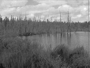
The site is dominated by treed muskeg (28.3% of the total area) but treed muskeg is comprised of a mix of semi-treed bog, treed bog and a complex of meadow marsh, shore fen and treed fen (Map 2a, Appendix 2). The dominant forest communities are Jack Pine (Pj) dominant conifer
Old growth (Map 5), based on Bridge et al (2000) criteria and standard forest units (SFU), were found in the majority of the cedar (Ce) dominated stands and many of the tamarack and black spruce stands in association with the treed muskeg areas. Two stands southwest of Tomfox Lake were candidate old growth but they have been recently harvested. Many more of the forest communities around the treed muskeg areas are probably old growth and older than reported in the FRI (Burkhardt, Longyear, King, 2002). Only ground-truthing would verify this assumption.
The forest communities are redefined as Standard Forest Units (SFU’s). Northeastern Region SFUs are used in forest management planning to more effectively describe the forest canopy. After treed muskeg, the site is dominated by SB1 (black spruce lowland (17.2% of the total area)), PJ1 (pure jack pine (11.1%)), SP1 (upland spruce (8.2%)) and BW1 (birch and poplar (8.1%)). Of the 14 SFU’s, only 2 were less than 1% in total area. SB1 incorporated most of the Sb dominated stands except those that contained tamarack and cedar which then became LC1 (Lowland conifer) or black spruce site class 4 which became BOG. PJ1 (pure jack pine) incorporated the majority of the Pj dominated stands and were associated with sand dunes or bedrock-drift complex. Other SFU’s include MW2 (spruce fir mixed), MW1 (jack pine mixed), P01 (poplar), PJ2 (jack pine mixed with spruce) and SF1 (upland spruce and fir).
Wetlands
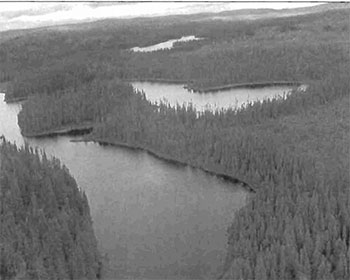
The extreme north end of the conservation reserve is located in the tertiary watersheds of 4MD and 4LA of the Moose River major basin and the rest of the site in tertiary watershed 2JD of the Ottawa River major basin (OMNR 2002). All the waterbodies in the area are clear and dark in colour. Headwaters are abundant in the area including several creeks to McCollum Creek and Ashley Lake system and several systems feeding Whitefish River.
5.0.2 Quality of representation
The quality of the representation or the current characteristics of the natural features found within the conservation reserve are as important as the overall representative features that are being protected. A number of factors are considered in evaluating a site and they include the following criteria: diversity, condition, ecological factors, special features and current land use activities.
a) Diversity
Diversity
Besides SFU’s, development stages will add to the diversity. All of the SFU’s (except for MW1) are represented by immature and mature forest communities with some old growth in SB1, SP1 and LC1. Wetlands also add to the diversity. The 3 FRI wetlands are represented by shore fens, meadow marsh, semi-treed bog, treed bog, poor fen and open water marsh. As well, some the forest communities are classified as treed fen, treed bog and conifer swamp. Dispersion is another consideration in diversity. For this conservation reserve, there is good dispersion of all of the SFU’s in the northwest half but in the southeast, dispersion is low. This half is predominantly represented by PJ1 and SB1.
“Evenness”
b) Condition
Condition
c) Ecological factors
Ecological factors refer to the current design of the conservation reserve as noted by its size, shape, and ability to protect core ecosystems from adjacent land use activities. Whenever possible, a site’s boundaries should be created to include the greatest diversity of life and earth science features to provide the maximum ecological integrity. It should be ecologically self-contained, bound by natural features and include adequate area to protect the core ecosystems from intrusive adjacent land use influences (OMNR 1992).
This site is bounded mostly by biological borders including McCollum Creek, Tomfox Lake, East Whitefish Lake and Neegeek Lake. Cultural boundaries such as Highway 566 on the south side and Argyle Lake Road were used. The rest of the boundaries are vectored. The site also contains several mining claims which may lapse in the future and potentially new areas can be assigned to the conservation reserve. The peninsula projection in Neegeek Lake, McNeil Township offers the least protection of core values. The narrowest section is approximately 200 meters wide and the area consists of many vectors (including township line). There is little protection to the forest communities if any activities were to occur adjacent to the CR if the boundaries are not properly marked. To make it more ecologically sound, the area south of Neegeek Lake to the unnamed creek with the road acting as the east boundary should be included into the CR (see Appendix 1- Ecological Considerations). There are no natural features in the north to use to replace the vectored boundary. The vectored boundary in the Argyle Creek area could be replaced using the trail and creek centerlines to Whitefish River.
Currently we do not have minimum size standards for conservation reserves under different landscape conditions. However, a minimum size standard of 2000 ha has been established for natural environment parks by Ontario Parks (OMNR 1992). This minimum standard was considered necessary to protect representative landscapes as well as allow for low intensity recreational activities. This conservation reserve has met the minimum standard at 3834 hectares. The size provides adequate protection from any intrusive influences on the core ecosystem (wetlands, black spruce, jack pine and white birch forests, etc.). The many biological boundaries limit the amount of trespassing that can occur. Without the existing trails and roads within the site, the amount of recreational activity is limited by the large wetland complexes occurring throughout.
d) Special features
One of the special features of this conservation reserve is the excellent example of parabolic sand dunes with its associating black spruce and/or jack pine forest communities and the surrounding wetlands, usually semi-treed bog and/or treed bog. Another special feature is the good representation of the different forest communities. Only white and red pine and tolerant hardwood stands are mixing from the site.
e) Current land use activities
Current activities include fishing, canoeing, swimming, camping, hunting, trapping, ATV use, and potentially snowmobiling. This area is also being heavily utilized by a commercial tourist establishment on the South side of Argyle Lake.
5.0.3 Summary
Whitefish River Sandy Till Conservation Reserve is a locally significant area represented by treed muskeg (28.3% of the total area) and lowland black spruce (17.2%). Wetlands account for nearly 1/3 of the total area according to the FRI but actually cover a greater area than this as many forest communities can be classified as treed bog, treed fen and conifer swamps. A total of 32 landform:vegetation combinations were determined.
The most sensitive feature of the site would be the treed muskeg areas, particularly to motorized vehicles. The many biological boundaries protect much of the conservation reserve from any intrusive influences such as harvesting, road construction and gravel extraction.
5.0.4 Natural heritage representative features
This site is characterized by areas of treed muskeg with stands of jack pine dominant conifer associated with the sand dunes and the bedrock-drift complex; pure black spruce associated with the sand dunes and the semi-treed/treed bog wetland complexes; and black spruce dominant conifer found within the wetland complex. The landform is characterized by flat to gently rolling, glacial clay and sandplain with locally extensive peatlands and wetlands, broken throughout by glacial features such as moraines, eskers with Canadian Shield exposure. The forest climate type is mid-humid, mid-boreal (Poser 1992; Noble 1983).
Landform-Vegetation (LV) type
Table 3: Vegetation types
This table not yet completed by Regional Office.
5.0.5 Forest Resource Inventory (FRI) data
- Dominant species, wetlands, and depleted areas
- See Forest Communities Map (Map 2a, Appendix #8)
5.1 Social/economic interest in area
5.1.1 Linkage to local communities
The Whitefish River Sandy Till Conservation Reserve is a 3834 ha parcel of Crown land that is situated approximately 70 km southwest from the Town of Kirkland Lake and 18 km west of the Town of Matachewan. This site is found within Cleaver, McNeil, Hincks, Argyle and Bannockburn Townships in the Districts of Kirkland Lake and Timmins (Locator Map, Appendix #7).
Current uses include fishing, canoeing, swimming, camping, hunting, trapping, ATV use, and snowmobiling. Potential recreational activities could include nonconsumptive uses such as bird watching, photography or nature study.
5.1.2 Heritage estate contributions
The Whitefish River Sandy Till Conservation Reserve contributes to the province’s parks and protected areas system through its regulation, representation and the long-term management of natural heritage values. By allocating these lands to the Parks and Protected Areas System, the province has ensured a certain level of permanence by distinguishing the site and its values from the broader general use or more extensively managed landscape. In addition, its natural features are, and will be available for present and future generations to enjoy and explore.
5.1.3 Aboriginal groups
The Whitefish River Sandy Till Conservation Reserve falls within the Matachewan and Temagami First Nations and the Teme-Augama Anishnabai Aboriginal Community’s identified notification area.
Temagami First Nations and Teme-Augama Anishnabai Aboriginal Community requested that draft copies of this SCI were simply mailed to them. This was done and they were given more than 30 days to provide comments. To date no comments have been received.
MNR staff met with Matachewan First Nations to present this draft SCI and to request their input to this document. A second meeting was scheduled where members of council and the community had the opportunity to voice opinions and influence wording and content of this SCI.
5.1.4 Mining interests
There are two current mining leases (L737273 & L737274) within the conservation reserve (shown as Forest Reserves). Mining and surface rights have been withdrawn from staking within the conservation reserve’s boundaries under the Mining Act (RSO 1990 Chapter M.14). Access to these claims, should it become necessary, will be considered through a Test of Compatibility.
5.1.5 Forest and fire management history
This conservation reserve has a widely varied age range (Appendix 8, Map 2c). The most prominent age group ranges from 60-89 years. This is especially true for the south-eastern portion of the reserve which burnt in the 1935 fire (Appendix 8, Fire Map). A section in the middle of the reserve which is shown on the Age Distribution, Stocking Distribution, Forest Communities, SFUs, Values, and Ecological Considerations Maps (Appendix 8) as a 318 ha depletion caused by harvesting is actually of unknown origin and was likely caused by disease or insects.
A 113 ha area along the southern edge of the CR was harvested in 1997, as were two small harvests equaling 80 ha in the south-eastern most portion of the CR. In 1998, a 204 ha harvest took place just north of this. A 206 ha harvest occurred in 2000 west of Argyle lake, most of which fell outside of the Conservation Reserve. Also in 2000 there was a 465 ha harvest just east of the vectored boundary north of Tomfox Lake.
5.2 Natural Heritage Stewardship
Based on the analysis done by Ontario Parks (2003), there are 32 landform:vegetation (L:V) combinations, of which 13 account for <1% of the total area. Forest reserves were removed from this analysis. There are 14 SFU’s (2 account for <1% of the total area) and approximately 6 different landform types. With SFU’s and Kristjansson’s (2004) interpretation of the landforms, the diversity rating is expected to be medium to high. Examples of L:V’s include SB1 and PJ1 on parabolic sand dunes (unit 7), P01 on esker (unit 4), PJ1, MW2, BW1 on bedrock-drift complex (unit 2) and BOG on organic deposits (unit 9). Kristjansson’s interpretation and a L:V map and table are pending.
5.3 Fish and wildlife
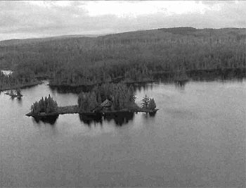
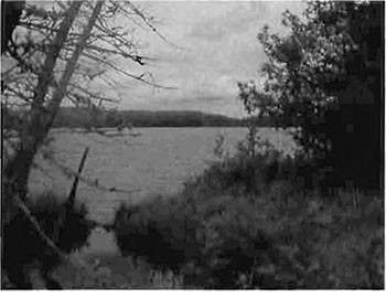
Argyle Lake contains northern pike, small mouth bass and walleye. The most recent data on the lake is from 1974 before the lodge was built on the lake. At the time Argyle Lake was listed as a self sustaining warm water fishery. The current status of the fishery is unknown.
Ashley Lake and Powell Lake both border site C1596 and provide an opportunity for fishing. Both are listed as warm water fisheries with walleye, northern pike, yellow perch and whitefish. The Whitefish River runs through the site and contains a self-reproducing population of brook trout. The northern section of the river near Nighthawk Lake in the Timmins District contains provincially significant wetlands and is home to a number of fish species. The river is thought to contain migration and spawning areas for pike. Nighthawk Lake contains sauger, walleye, perch, cisco, white sucker and whitefish and it is thought some of these species may also be found in the river. A survey of the Whitefish River would be beneficial to this and future documents pertaining to the site. Further assessment and management will continue under the Kirkland Lake District, Elk Lake/Matheson Area Supervisor.
The main recreation activity in C1596 is hunting and fishing. There is a lodge south of Argyle Lake, on patent land, which is surrounded by the conservation reserve. The lodge is a hunting and fishing lodge that specializes in large mammal hunting. Moose were observed within the site during aerial reconnaissance and evidence of both moose and bear were observed during field visits (Telford, 2004). Bear baiting was evident on many of the trails found within the conservation reserve. The area contains two bear management areas.
5.4 Cultural Heritage Stewardship
To date, little is known regarding the cultural values of the Conservation Reserve as a detailed assessment of cultural resources has not been carried out.
5.5 Land use/existing development
This conservation reserve is situated entirely on Crown land and is unencumbered by any patented land, land use permits, or leases. It does, however, overlap three mining claims, (737273, 737274 & 1167177) which have been designated as forest reserves.
A forest reserve is a land use designation (LUS 7.2.3) applied to areas that were initially identified for inclusion in the conservation reserve (CR) but were subsequent detailed examination determined that there were existing mining leases or claims.
Mining and surface rights have been withdrawn from staking within the conservation reserve boundaries under the Mining Act (RSO 1990 Chapter M.14). Therefore, no new claims can be staked within the CR boundary. The intent is that the forest reserve (FR) will be added to the CR if the claim or lease is retired through normal process.
Policies for FR’s are similar to the policies for new CR’s, except that mining, and related access, is allowed in a forest reserve.
5.6 Commercial land use
Present commercial use activities overlapping the site include two Bear Management Areas (KL-29-032 & KL-29-034) and two traplines (KL033, & KL079) Map 3A, Appendix 8).
5.7 Tourism/recreation use/opportunities
Some of the features within the site associated with possible recreational use include water bodies, large mammals, trails or routes, beaches, Eolian sand dunes and aquatic flora and fauna. Existing recreational uses in this site and immediately surrounding the site include trapping, hunting, canoeing, camping, swimming, ATV use, fishing and snowmobiling. There is also potential for activities such as bird watching and nature study.
For a more detailed report and summary of the recreational use and potential, refer to the Recreational Inventory Check-sheet (Appendix 3).
5.8 Client services
Currently, visitor services are limited to responding to inquiries about access, natural heritage features and boundaries. No formal information or interpretive facilities currently exist within the conservation reserve. Other customer services available through the Kirkland Lake District office include providing clients with maps, fact sheets, and other information gathered on the area, such as the earth/life sciences and recreational inventory work.
6.0 Management guidelines
6.1 Management planning strategies
The land use intent outlined in the OLL LUS (MNR, 1999) provides context and direction to land use, resource management, and operational planning activities on Crown Land in the planning area and within OLL site boundaries. Commitments identified in the OLL LUS and current legislation (Policy 3.03.05 PLA) forms the basis for land use within the Whitefish River Sandy Till Conservation Reserve. Management strategies for these uses must consider the short and long-term objectives for the conservation reserve. For up to date information on permitted uses refer to the Crown Land Use Atlas (MNR, 2002) (Appendix 6).
Proposed new uses and development will be reviewed on a case-by-case basis. A Test of Compatibility, (Procedural Guideline B-Land Uses (Appendix 4)) must be completed before proposals can be accepted. In all cases, ensuring that the natural values of the conservation reserve are not negatively affected by current and future activities will be the priority. Therefore any application for new specific uses will be carefully studied and reviewed.
6.1.1 Forest reserves
Under the OLL LUS, mining and related access will be allowed in a forest reserve. For those activities that could negatively influence the natural heritage values within the FR and/or the CR, the district will work with the proponent to identify and mitigate potential mining or natural heritage concerns. Mining will not occur in any portion of the regulated conservation reserve boundary.
6.2 “State of the resource” management strategies
The development of this SCI and the long term management and protection of the Whitefish River Sandy Till Conservation Reserve will be under the direction of the MNR’s Kirkland Lake District, Elk Lake - Matheson Area Supervisor. The following management strategies have been created to achieve the goal and objectives stated earlier in this management document.
6.2.1 Natural heritage stewardship
The management intent for the Whitefish River Sandy Till Conservation Reserve is to allow for natural ecosystems, processes and features to operate undisturbed with minimal human interference while providing educational, research and recreational activities. Forest ecosystem renewal will only be entertained via a separate vegetation management plan. As part of any future vegetation management plan the site and its Site EcoDistrict will be re-evaluated with respect to their known landform/vegetation features to determine if the previously harvested areas could contribute additional landform/vegetation values to the Site EcoDistrict.
In addition, the vegetation management plan will need to determine but not be limited to:
- the restoration ecology objectives (e.g. representation) for the area in context with the Site EcoDistrict
- consider current provincial strategies (e.g. white pine)
- consider larger long-term conservation reserve (e.g. recreational objectives) and possibly landscape objectives (e.g. contributions to landscape wildlife objectives)
Fire is recognized as an essential process fundamental to the ecological integrity of conservation reserves. In accordance with existing Conservation Reserve Policy and the Forest Fire Management Strategy for Ontario, forest fire protection will be carried out as on surrounding lands.
Whenever feasible the MNR fire program will endeavor to use “light hand on the land” techniques, which do not unduly disturb the landscape, in this conservation reserve. Examples of light hand on the land techniques may include limiting the use of heavy equipment, utilizing high water bomber drops, non use of foaming agents, or limiting the number of trees felled during the fire response efforts.
Opportunities for prescribed burning to achieve/emulate ecological or resource management objectives may be considered. These management objectives will be developed with public consultation prior to any prescribed burning, and reflected in this document, which provides management direction for this conservation reserve. Plans for any prescribed burning will be developed in accordance with the MNR Prescribed Burn Planning Manual, and the Class Environmental Assessment for Provincial Parks and Conservation Reserves (approval pending).
Defining compatible uses, enforcing regulations and monitoring and mitigating issues will protect all earth and life science features. Industrial activities such as commercial timber harvest and new hydro generation will not be permitted within the conservation reserve. Permits for fuel-wood will not be issued. New energy transmission, communication and transportation corridors or construction of facilities are not permitted within the boundaries of the conservation reserve. Such structures negatively impact the quality of the representative features that require protection. Alternatives should be reviewed via larger landscape planning processes. Other activities that do not pass a Test of Compatibility will be prohibited (MNR Policy 3.03.05, 1997).
The introduction of exotic and/or invasive species will not be permitted. Programs may be developed to control forest insects and diseases where they threaten significant heritage, aesthetic, or economic values. Where control is desirable, it will be directed as narrowly as possible to the specific insect or disease. Biological or non-intrusive solutions should be applied whenever possible.
The collection/removal of vegetation and parts thereof will not be permitted; however, subject to a Test of Compatibility, the Area Supervisor may authorize such activities for purposes of rehabilitating degraded sites within the reserve, collecting seeds for maintaining genetic stock and/or for inventory or research purposes.
MNR will provide leadership and direction for maintaining the integrity of this site as a heritage estate. To ensure MNR protection objectives are fully met within the conservation reserve, activities on the surrounding landscape must consider the site’s objectives and heritage values. Research, education and interpretation will be encouraged to provide a better understanding of the management and protection of the natural heritage values and will be fostered through local and regional natural heritage programs, initiatives and partnerships.
The conservation reserve will be managed by allowing natural ecosystems, processes, and features to function normally, with minimal human interference.
6.2.2 Fish and wildlife
Fish and wildlife resources will continue to be managed in accordance with specific policies and regulations defined by the Ontario Ministry of Natural Resources under the Fish and Wildlife Conservation Act and the Kirkland Lake District, Elk Lake - Matheson Area Supervisor. The final decision to allow fish stocking in the Whitefish River Sandy Till Conservation Reserve lies with the approval of the Kirkland Lake District Manager.
6.2.3 Cultural heritage
When possible, the Ministry of Natural Resources will continue to work with the Ontario Ministry of Culture, Tourism and Recreation in identifying archaeological sites to be protected. To more fully manage and protect sites, the development of field surveys would be required.
Development, research and education proposals may be considered in accordance with the Test of Compatibility and Conserving a Future for our Past: Archaeology, Land Use Planning & Development in Ontario, Section 3 (OMC, 1997).
6.2.4 Land use and development
The sale of lands within the conservation reserve is not permitted as per the OLL LUS (MNR, 1999). Existing authorized trails can continue to be used and maintained, unless there are significant demonstrated conflicts. New trails will only be allowed if a Test of Compatibility is passed. Any new trail development will require an amendment to the SCI. The cutting of trees for non-commercial purposes (e.g. fuelwood) is not permitted except as required for approved development activity (e.g. trail, viewing site, etc.). Existing roads may continue but new roads will not be permitted except when necessary for resource extraction. These roads will be permitted under the Class Environmental Assessment Act (Ontario Parks, 2004).
There are no other forms of tenure in the conservation reserve other than legal agreements with registered trappers, and bear management area operators. The construction of new trap cabins will not be permitted; however, existing cabins will be allowed to continue (LUS MNR, 1999).
Traditional uses within the conservation reserve will continue to be permitted; however, the goal will be to resolve conflicts regarding incompatibility between uses and to ensure that identified values are adequately protected.
6.2.5 Commercial use
All existing commercial resource use activities (i.e. trapping, baitfish harvesting, fishing and wild rice harvesting) are permitted to continue and new uses (with the exception of commercial bear hunting) may be introduced, subject to protection of the conservation reserve’s natural heritage values (i.e. test of compatibility).
Commercial bear hunting (within BMA) operations may continue and the transfer of existing licenses is allowed, providing the activity has been licensed/permitted since January 01, 1992. Licenses to provide Bear Hunting Services will not be issued in areas where issuance has not occurred since January 01, 1992.
Existing commercial fur harvesting operations are permitted to continue. New operations may be considered subject to a Test of Compatibility.
6.2.6 Aboriginal interests
The Whitefish River Sandy Till Conservation Reserve is within the Matachewan and Temagami First Nation’s identified area of interest and the Teme-Augama Anishnabai Aboriginal Community’s identified area of interest, therefore invitations for comment and participation have been extended. Aboriginal and treaty rights will continue to be respected throughout the management of this conservation reserve. The members of the Matachewan First Nation are governed by the James Bay Treaty #9. The land encompassed by this CR is governed by the Robinson Treaty. For further details of these treaties please see Appendix 10 (Treaty #9) and Appendix 11 (Robinson Treaty).
Any future proposal(s) and or decision(s) that have potential impact(s) on individual aboriginal values and or communities will involve additional consultation with the affected aboriginal groups. Neither the regulation of this conservation reserve nor the approval of this SCI will have bearing on the Matachewan, Temagami or Teme-Augama Anishnabai traditional land uses.
6.2.7 Tourism/recreation
Most recreational activities that have traditionally been enjoyed in the area can continue provided they pose no threat to the natural ecosystems and features protected by the conservation reserve. These permitted activities include walking, hiking, wildlife viewing, fishing, hunting, snow shoeing, and cross-country skiing.
Snowmobiles and All Terrain Vehicles (ATVs) are permitted on existing trails and forest access roads within the Conservation Reserve. Under the OLL LUS (MNR, 1999), all mechanized travel is restricted to existing trails. Off-trail vehicle use is permitted for the retrieval of game only. The use of existing trails, within the Whitefish River Sandy Till Conservation Reserve, does not degrade the values of this site.
Existing trails for hiking, snowmobiling, ATV use, cycling, horseback riding and cross-country skiing can continue. To ensure the quality of the representation is maintained, all trails and old forest access roads (Road Access Map, Appendix 8) within the site should be identified via new technologies (i.e. GPS) to ensure a record of these features exists. New trails can be considered through a Test of Compatibility.
Finally, conflict resolution between recreational uses will be a priority. This will be achieved by adhering to the objectives of this SCI with input from relevant user groups. The level of safety and compatibility between activities will determine permitted uses (i.e. Test of Compatibility).
6.2.8 Client services
Clients indicating their interest in the management, planning and future use of this conservation reserve will be put on a mailing list and notified of any future planning concerning the site.
Present client services such as supplying maps, fact sheets and other information will also continue. Information may be delivered from different sources; however, MNR will be the lead agency for responding to inquiries regarding access, permitted and restricted activities, values and recreation opportunities. A management agreement may be pursued with an appropriate partner to share responsibilities for information services and the delivery of other aspects of this SCI in the future.
6.3 Specific feature/area/zone management strategies
There are no specific management strategies for the maintenance/protection/enhancement of selected resources within the conservation reserve. Development of such strategies will require an amendment to the SCI.
6.4 Promote Inventory, Monitoring and Assessment Reporting (IMAR), and research
Scientific research by qualified individuals, which contributes to the knowledge of natural and cultural history, and to environmental and recreational management, will be encouraged.
Research related to the study of natural processes will be encouraged provided it does not harm the values of the reserve. The Elk Lake - Matheson Area Supervisor or District Manager may approve the removal of any natural or cultural specimen by qualified researchers. All such materials removed remain the property of the Ministry of Natural Resources. All research programs will require the approval of the Ministry of Natural Resources and will be subject to Ministry policy and other legislation.
New research developments such as campsites, privies, trails or developed access points or activities will not be considered until a Test of Compatibility is conducted and the proposal is approved by the Elk Lake - Matheson Area Supervisor or District Manager. The Test of Compatibility or Environmental Screening Process could include a review of the demand for structures or activities and may require more detailed life and/or earth science and/or cultural information and possibly a more detailed management plan.
Approved research activities and facilities will be compatible with the site’s protection objective. Permanent plots or observation stations may be established to which researchers can return over time. Any site that is disturbed will be rehabilitated as closely as possible to its original state.
6.5 Implementation, and plan review strategies
Whitefish River Sandy Till Conservation Reserve SCI will be reviewed on an ongoing basis and as required.
Implementation of the SCI and management of the reserve are the responsibility of the Elk Lake - Matheson Area Supervisor. Partnerships may be pursued to address management needs.
If changes in management direction are needed at any time, the significance of the changes will be evaluated. Minor changes that do not alter the overall protection objectives may be considered and approved by the District Manager without further public consultation and the plan will be amended accordingly. In assessing major changes, the need for a more detailed Resource Management Plan will first be considered. Where a Resource Management Plan is not considered necessary or feasible, a major amendment to this SCI may be considered with public consultation. The Regional Director must approve major amendments.
6.6 Marketing strategies
Whitefish River Sandy Till Conservation Reserve will be marketed as a representative natural area having Earth and Life Science values, as well as certain recreational values. Marketing efforts to increase use are not a priority and will be kept to a minimum.
6.7 Boundary identification
There is no stated policy to mark the boundaries of a Conservation Reserve. Local management discretion can be used to determine where boundary marking may be appropriate. In order for restrictions to be enforceable, signs must be placed in accordance with the Trespass to Property Act or subsection 28 (1) of the Public Lands Act to advise against any recreational activities.
7.0 References
Arnup, R., G.D. Racey and R.E. Whaley. 1999. Training manual for photo interpretation of ecosites in northwestern Ontario. NWST Technical Manual TM-003.127p.
Bridge, Simon; Watt, Robert; Lucking, Greg; and Brian Naylor. 2000. Landscape analysis for forest management planning in boreal northeastern Ontario. OMNR, Northeast Science & Technology. 36p.
Burkhardt, B.C. 2003. C1596 aerial reconnaissance notes.
Burkhardt, B., Longyear, S, King, L. 2002. Natural Heritage Area - Life Science Checksheet
Hills, G.A. 1959. A Ready Reference to the Description of the Land of Ontario and its Productivity.
Keddy, C. 1997. Natural Heritage Gap Analysis for Site District 3E-5: GIS Analysis. by Geomatics International Inc.
Kristjansson, R. 2004. Personal Conversation.
Lee, Hulbert A. 1979. Northern Ontario Engineering Geology Terrain Study, Data Base Map, Kirkland Lake. Ontario Geological Survey, Map 5030, Scale 1:100 000.
Nicholson, J. 2003. C1600 Aerial Reconnaissance Notes.
Noble, T.W. 1983. Central Boreal Forest Region (3E). Life Science Report. Northeastern Region. Internal report.
NTS topographic mapping (32 D/NW).
Ontario Ministry of Culture (OMC). 1997. Conserving A Future for Our Past: Archaeology, Land Use Planning and Development in Ontario. Toronto: Cultural Programs Branch, Archaeology & Heritage Planning Unit.
Ontario Ministry of Culture (OMC). 1992. Ontario Provincial Parks: Planning and Management Policies Update.
Ontario Ministry of Culture (OMC). 1995. Forest Resource Inventory Mapping
Ontario Ministry of Culture (OMC). 1997c. Ontario Watershed Mapping.
Ontario Ministry of Natural Resources. 1999. Ontario Living Legacy Land Use Strategy.
Ontario Ministry of Natural Resources. 2002. MNR Districts and Major Basins of Ontario.
Ontario Parks. 2003. Landform/Vegetation Representation Summary for site C1596 in Ecodistrict 3E-5. (May 2003). Internal Report
Ontario Parks. 2004. A Class Environmental Assessment for Provincial Parks and Conservation Reserves.
Poser, S. 1992. Report of the status of provincial parks in the site region and districts of Ontario. Ministry of Natural Resources Report.
Roed, M.A. and D.R. Hallett. 1979. Northern Ontario Engineering Geology Terrain Study, Data Base Map. Elk Lake. Ontario Geological Survey, Map 5020, Scale 1:100 000.
Rowe, J.S. 1972. Forest Regions of Canada. Department of Fisheries and the Environment-Canadian Forestry Service Publication No. 1300. 172p.
Thompson, John E. & Jake Noordhof. 2003. Edit Model for N.E. Region Life Science Checksheets. Internal Report.
Appendix 1: Public consultation summary
SCI public consultation summary (C1596)
| Date received | Client | Comment | Action taken | Date of response |
|---|---|---|---|---|
| September 5, 2000 | 44 | Faxed request for info on site | Called to discuss details on info required Mailed requested info |
September 7 September 8 |
| March 21, 2001 | 56 | Called requested info on site, concerned about use of recently purchased camp within this area, wanted to know permitted uses re: tourism | Sent general OLL LUS and C1596 fact sheet, added to contact list | March 22 |
| March 23, 2001 | 48 | Asked in a letter to be added to contact list | Added | April 18 |
| December 6, 2002 | 52 | Called and asked to be added to contact list | Added and sent notice letter regarding SCIs | December 6 |
| January 12, 2005 | 59 | Called and asked for a copy of the SCI | Sent SCIs, added to contact list | January 13 |
| January 19, 2005 | 60 | Called and asked for SCI, was concerned about Geocaching in the area and it’s effect on the pristine wilderness | Researched Geocaching in the area, found none, sent SCI, asked for further info on Geocaching | January 20 |
| January 31, 2005 | 61 | Visited office, requested further info on CR and how it affects his trapline | Sent SCI and map clearly outlining the boundaries of his trapline and of the CR | February 1 |
Appendix 2: Public consultation ad
Review of draft Statements of Conservation Interest
C1596 Whitefish River Sandy Till
C1602 Whitefish and East Whitefish Lakes Sandy Till Uplands
C1626 South Grassy Lake Outwash
C1714 MacDougal Point Peninsula
The Ministry of Natural Resources (MNR) invites you to review the draft Statements of Conservation Interest (SCI) for the Whitefish River Sandy Till, Whitefish and East Whitefish Lakes Sandy Till Uplands, South Grassy Lake Outwash and MacDougal Point Peninsula Conservation Reserves. Copies of these draft documents will be available for review at the Kirkland Lake District MNR office until February 21st, 2005.
The Whitefish River Sandy Till Conservation Reserve is situated 18 km northwest of the town of Matachewan. This Conservation Reserve is located within the townships of Cleaver, McNeil, Hincks, Argyle and Bannockburn and is 3,399 hectares in size. The Whitefish and East Whitefish Lakes Sandy Till Uplands Conservation Reserve is situated 20 km north of Matachewan and approximately 65 km west of the town of Kirkland Lake. This Conservation Reserve is located within Robertson, Baden, Sheba, Alma and Michie townships and is 9,353 hectares in size. The South Grassy Lake Outwash Conservation Reserve is found 17 km southeast of Kirkland Lake. This Conservation Reserve is located within McElroy and Hearst Townships and is 425 hectares in size. The MacDougal Point Peninsula Conservation Reserve is located 65 km north of Kirkland Lake and 45 km east of Iroquois Falls, in Rand, Frecheville and Stoughton townships. This Conservation Reserve is 6,035 hectares in size.
The Statements of Conservation Interest identify area values and provide direction on resource management activity and appropriate land uses. As conservation reserves, commercial activities such as forest harvesting, mining and hydroelectric power development are prohibited from occurring within the protected area. The Ministry of Natural Resources (MNR) is collecting comments and information regarding the draft Statements of Conservation Interest under the authority of the Public Lands Act (1990) to assist in making decisions and determining future public consultation needs. Comments and opinions will be kept on file for use during the plan’s operating period and may be included in the study documentation, which is made available for public review.
Under the Freedom of Information and Protection of Privacy Act (1987) personal information will remain confidential unless prior consent is obtained. However, this information may be used by the Ministry of Natural Resources to seek public input on the other resource management surveys and projects. For further information on this Act, please contact
Shaun Walker at 705-568-3231
If you would like additional information or would like to supply background information or viewpoints to be considered by the planning team, please contact:
Jessy Malone or Jody Bissett
Land Use Planners
Ministry of Natural Resources
Kirkland Lake District
P.O. Box 910, 10 Government Road East
Kirkland Lake, ON
P2N 3K4
Fax:
Comments will be accepted until February, 21st, 2005
Renseignement en francais:
Appendix 3 Recreational Inventory Checksheet
Recreation Inventory Report - Whitefish River Sandy Till Conservation Reserve C1596
January 15, 2004
Prepared For: OMNR, Northeast Region
Jennifer Telford
Kirkland Lake District, OMNR
1.0 Introduction
The Whitefish River Sandy Till Conservation Reserve is located in north eastern Ontario approximately 70 kilometres from the Town of Kirkland Lake.
Conservation Reserves identified in Ontario’s Living Legacy Land Use Strategy (LUS) were given interim protection and the intention is to have all of the sites formally regulated under the Public Lands Act by 2004. The process to regulate the Whitefish River Sandy Till Conservation Reserve is currently underway, and regulation is expected in the spring of 2004.
In addition to the regulation process, a number of inventories, including a Recreation Inventory Report, are being conducted in the Living Legacy sites. Recreation inventories are particularly important to the OLL planning process, as one of the major objectives of the LUS is to ensure that a broad range of natural resource-based recreation opportunities are provided for. As a result the Ontario’s Living Legacy Guidelines for Recreation Assessment were developed. Under the guidelines all inventories are guided by four basic objectives:
- Identify landforms and features, which are or may be used for recreation
- Identify the range of settings that the protected area is able to provide
- Identify all known existing recreational activities
- Identify all means by which the protected area can be accessed
The Whitefish River Sandy Till Conservation Reserve Inventory was influenced by the four basic objectives but it also attempts to evaluate the impact of humans in the site.
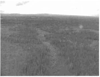
Figure 1: Whitefish River Sandy Till Conservation Reserve C1596, Map Overview
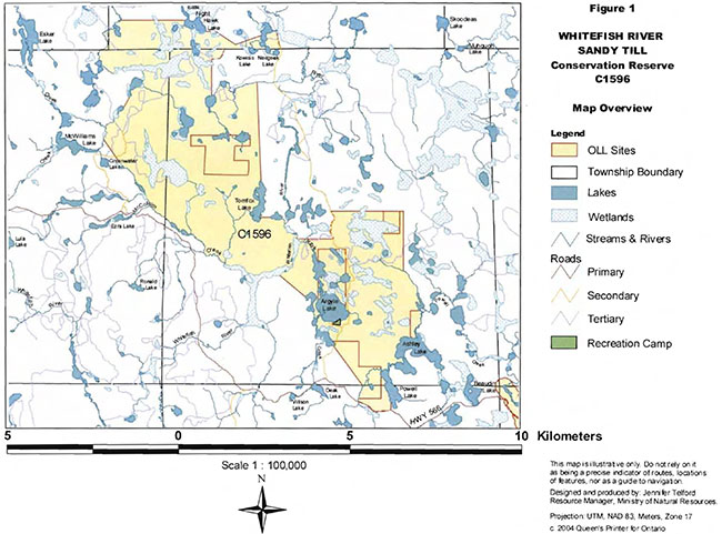
Enlarge Figure 1: Whitefish River Sandy Till Conservation Reserve C1596, Map Overview
3.0 Description of the study area
3.1 General setting
The Whitefish River Sandy Till Conservation Reserve is located in Argyle, Hincks, Bannockburn and McNeil townships. The site is primarily in the Kirkland Lake District with part of the west and north of the site being in the Timmins District. The Kirkland Lake District has the lead role in the regulation process. The conservation reserve covers an area of 3516 hectares. The nearest community is the Town of Matachewan approximately 20 kilometres to the east of the conservation reserve.
A few other protected areas are within close proximity to the site. These areas are all Ontario Living Legacy Sites. The Mistinikon Lake Uplands and Dunmore Township Balsam Fir Outwash Deposit Conservation Reserves have already been regulated and the Whitefish and East Whitefish Lakes Sandy Till Uplands Conservation Reserve will be regulated at the same time as this site. The Montreal River Provincial Park is also nearby and was regulated in 2002.
3.2 Cultural values
Little is known about the cultural values of the conservation reserve. The Matachewan First Nation has an interest in the land because it is in their traditional land use area.
3.3 Life science values
The life science evaluation for this site has not yet been completed. Tree species observed in the site during field visits include black spruce, white birch, jack pine and poplar. The site also contains old growth cedar as well as old growth black spruce and poplar (OLL Factsheet, 2002).
3.4 Earth science values
The earth science evaluation for this site is not yet complete. Early information suggests the site is strongly broken deep and shallow sandy till with relief and bare bedrock.
4.0 Methodology
Primary and secondary resources were used to gather information for this recreation inventory report. Primary research consisted of field site visits and discussions with district staff. Secondary research was done prior to field visits.
Table 1
| Primary research | Secondary research |
|---|---|
| One ground visit (July 29, 2003) | Internal OLL documents |
| Aerial visit (September 24, 2003) | OBM and OLL Maps |
| Contact with District staff | Air Photos |
The ground visit was a day in length and covered as much of the site as possible. The ground visit was made with a four-wheel drive truck and ATV’s. Most of the travel done within the Conservation Reserve was by ATVs. Land routes and road access were documented with a GPS unit and digital photographs were taken of interesting features. Water routes were not explored due to lack of access to most lakes or the inability to transport any form of water craft into the site.
Information gathered from the site visit was then used to complete the recreation checklist (Appendix A). The checklist was completed in accordance with the Ontario’s Living Legacy Guidelines for Recreation Resource Assessment, Version 3- May, 2002 and data was entered into the Microsoft Access form provided. A map of the site was created using the site access information gathered from the GPS unit.
5.0 Recreation features
Recreation features are biophysical or cultural attributes that may be able to support recreational activity. A total of six features were recorded and ranked according to their recreational value and importance in the Recreation Inventory Checklist (Appendix A). Listed features have a corresponding code and are classified under a specific category according to the Ontario’s Living Legacy Guidelines for Recreation Resource Assessment, Version 3- May, 2002. The following sections provide more detail on each of the features.
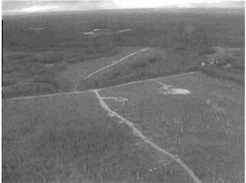
5.1 Land routes (T03) - Trails or routes
Access to the site is through the road to Argyle Lake Lodge. Beyond the lodge the road turns into ATV trails and is not passable by truck. There are numerous trails within the conservation reserve. The trails are used by the lodge during hunting season. It is believed the trails may also be used in the winter for snowmobiling but this has not been confirmed.
5.2 Large land mammals (W03) -Wildlife
The site contains moose and black bear. Moose were observed within the site during aerial visits and evidence of both moose and bear were observed during field visits. Moose and black bear tracks were observed on trails in the site. The site contains two Bear Management Areas and District staff is aware of both moose and bear hunting in the area.
5.3 Sport fish (A01) - Aquatic flora and fauna
Argyle Lake contains northern pike and walleye. The most recent data on the lake is from 1974 before the lodge was built on the lake. At the time Argyle Lake was listed as a self sustaining warm water fishery. The fishery may be depressed now due to over fishing from the lodge. Further analysis of the lake is recommended to determine the current state of the fishery. Ashley Lake and Powell Lake both border site C1596 and provide an opportunity for fishing. Both are listed as warm water fisheries with walleye, northern pike, yellow perch and whitefish. The Whitefish River runs through the site. The northern section of the river near Nighthawk Lake in the Timmins District contains provincially significant wetlands and is home to a number of fish species. The river is thought to contain migration and spawning areas for pike. Nighthawk Lake contains sauger, walleye, perch, cisco, white sucker and whitefish and it is thought some of these species may also be found in the river. An analysis of the Whitefish River within the Whitefish River Sandy Till Conservation Reserve would be beneficial to this and future documents pertaining to the site.
5.4 Waterbodies (M00) - Waterbodies
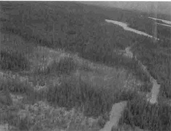
As mentioned above there are a number of lakes within the conservation reserve. Argyle Lake has the best access due to the lodge on the lake. There are a number of smaller unnamed lakes within the conservation reserve and a few larger lakes that border it, namely Tomfox, Ashley and Powell. The Whitefish River runs through the middle of the conservation reserve at the sites narrowest section. McCollum Creek forms part of the western border of the site and is a tributary of the Whitefish River.
5.5 Beach-General (B15) - Shores features
There are a few beach areas on Argyle Lake. The largest beach is part of the lodge but there are two very small beach areas adjacent to camping areas on the east side of the lake.
5.6 Wind-caused or Eolian (J03)- Landform, surface material
There are sand dunes in the northwest section of the conservation reserve. These are evident in a cutover but most likely can be found under the rest of the forest in that area.
6.0 Recreation activities
The recreation activities are closely related to the recreation features. Eight activities were recorded on the Recreation Inventory Checklist when the inventory was performed. Activities were selected from a list of known recreation activities included in the Ontario’s Living Legacy Guidelines for Recreation Resource Assessment,Version 3- May, 2002. The activities have a corresponding code and the existing activities were differentiated from potential activities by using a capital letter in their activity code. The following eight sections provide more details on each of the activities.
6.1 Game, large mammal (H01) - Hunting/trapping
The main recreation activity in C1596 is hunting. There is a lodge on patent land surrounded by the conservation reserve. The lodge is a hunting lodge that specializes in large mammal hunting. Bear baiting was evident on many of the trails found within the conservation reserve. The area contains two bear management areas. Moose were observed in the site during aerial reconnaissance and moose and bear tracks were observed during the field visit.
6.2 ATV (T01) - Travelling
There are many ATV trails within the conservation reserve and most of them are in good condition. At the time of the survey water levels were high and some of the trails were inundated. Most trails were still passable by ATV with only one surveyed trail having water too deep for an ATV.
6.3 Camping activities- General (K00) - Camping
There are a couple of camping areas in the conservation reserve on Argyle Lake. The campsites have access to the lake and they have small beach areas. There is a picnic table at one of the camping areas and both look to be used frequently throughout the summer. It is also a favourite spot of some of the district staff who can attest to the camping spots being used at least a few times each summer.
6.4 Fishing - General (F00) - Fishing
People fish in Argyle Lake from the lodge. The current fishing pressure on the lake is not known.
6.5 Trapping (H06) - Hunting/trapping:
The site contains two registered trap lines. There was no evidence of trap lines during the field visit but the field visit was conducted in the summer. It is not known exactly where the trap lines are located of if they are found along any of the trails surveyed during the summer.
6.6 Swimming/bathing (B13)- Water sports
The beach areas on Argyle Lake appeared to be suitable places to swim from during the field visit. The lake was sandy in these areas. The lodge has a large beach and it is assumed people swim in the lake from the lodge.
6.7 Canoeing (b02) - Water sports
Argyle Lake is a decent size for canoeing and there are a few good sized lakes (Ashley Lake, Powell Lake) that border the site that could be canoed as well. The Whitefish River is another potential area for canoeing and the Ontario Recreational Canoeing Association has identified this site as an interest to their group due to the canoeing opportunities linked to the Whitefish River system.
6.8 Snowmobiling (d10) - Snow sports
The ATV trails could also be used in the winter for snowmobiling. Winter field visits would be required to confirm that there is snowmobiling within the conservation reserve.
7.0 Recreation factors
The recreational factors provide a context for the information collected during the recreation inventory, as they are meant to provide some insight on how the site will contribute to outdoor recreation at the regional level.
7.1 Feature significance
Feature significance for the conservation reserve, which is a composite measure of feature scarcity and uniqueness, activity attraction capability, scenic attractiveness, and geographic significance, was rated as moderate. This designation resulted from the fact that the factors rated from high to low with most being rated as moderate.
The scarce feature in this conservation reserve is the beach areas on Argyle Lake. The beaches are quite small and appear to be unique to this lake within the site. Other lakes were encountered during the field visit but they did not have any type of beach on them.
The most unique feature is the sand dunes in the northwest of the site. Currently the earth science evaluation has not been prepared and therefore extensive information on the sand dunes is not available at this time.
The Whitefish River Sandy Till Conservation Reserve’s activity attraction capability was seen as moderate. The Argyle Lake Lodge is a draw during the hunting season and brings a number of people into the conservation reserve. The site is a favourite spot for campers in the summer. People who are camping in the site are there because it is remote and provides them with a quiet setting for their weekend excursions.
7.2 Feature sensitivity to recreation use
The sand dunes have been chosen as the most sensitive feature to recreation use because they can be damaged by ATV’s. Loosening the vegetation cover on the dunes can cause the sand to blow away. This erosion can lead to the destruction of the dune system.
7.3 Feature sensitivity to resource development
The sand dunes are also the feature most sensitive to resource development. Parts of the dunes have already been exposed from past logging in the site. The dunes in this area have lost their vegetation cover and have become more sensitive to erosion processes.
7.4 Cultural/historic and archaeological features
The Whitefish River Sandy Till Conservation Reserve has been rated as having cultural/historic features because it is within the Matachewan First Nation’s traditional use area. There is no record of any archaeological features and will be believed to be lacking in such features until further research is conducted in the site.
8.0 Recommendations
Upon completion of this first phase of recreational assessment, a series of recommendations were made. The recommendations are as follows:
8.1 Additional research
- Field visits should be made in the winter months to determine if the trails are used for snowmobiles
- The exact location of all trails within the conservation reserve should be determined with a GPS unit and mapped accordingly
- The lakes and rivers should be researched to determine what types of fisheries exist within the conservation reserve and the fishing pressure on Argyle Lake and in the rest of the site needs to be determined
- Conduct cultural/historic and archaeological survey of the conservation reserve
8.2 Future management
- Existing trails need to be mapped in order to enforce the LUS permitted uses with respect to new trails within OLL conservation reserves
References
Mulrooney, Dan. Ontario’s Living Legacy Guidelines for Recreation Resource Assessment, Version 3- May 2002. Ontario Parks, May 2002.
Ontario Ministry of Natural Resources. Whitefish River Sandy Till Conservation Reserve (C1596) Factsheet, September 2002.
Recreation Inventory Checklist - C1596 Whitefish River Sandy Till Conservation Reserve
- Map Name: Raddisson Lake
- NTS Number: 42/A02
- UTM reference: 508532
- OBM Number: 507/5323
- Latitude: 48°03′41″N
- Longitude: 80°53′47″W
- Area (ha): 3,516.00
- Ownership: Crown
- MNR Region: Northeast
- MNR District: Kirkland Lake
- Park Zone: Northeast
- Count: N/A
- Township: Argyle, Cleaver, McNeil, Hincks, Bannockburn
- Recreation:
- T03 - Land Routes
- W03- Land Mammals, Large
- A01 - Sport Fish
- M00 - Waterbodies, General
- B15- Beach, General
- J03- Wind Caused or Eolian
- Recreation
- H01 -Game, Large Mammal
- T01 -ATV
- K00 - Camping Activities, General
- F00 - Fishing, General
- H06 - Trapping
- B13- Swimming
- b02 - Canoeing
- d10- Snowmobiling
| Recreation | Features | Rating: Very High, High, Moderate, Low, N/A |
|---|---|---|
| Most Scarce Feature: | 5 | N/A |
| Feature Scarcity: | N/A | high |
| Most Unique Feature: | 6 | N/A |
| Activity Attraction Capability: | N/A | Moderate |
| Scenic Attractiveness: | N/A | Low |
| Geographic Significance: | N/A | Moderate |
| Feature Significance: | N/A | Moderate |
| Most Sensitive Feature To Recreation | 6 | N/A |
| Feature Sensitivity To Recreation Use: | N/A | Moderate |
| Most Sensitive Feature To Resource | 6 | N/A |
| Feature Sensitivity To Resource Development: | N/A | Moderate |
| Cultural/Historic and Archaeological Features: | N/A | Whitefish River Sandy Till Conservation Reserve is located in both Timmins and Kirkland Lake MNR Districts with Kirkland Lake assuming responsibility for the site. |
Date Compiled:
November 5th, 2003
Compiler:
Jennifer Telford
Source: Recreation Resource Inventory Standards and Procedures Draft Report, Gov. of British Columbia, Ministry of Forests Range, Recreation and Forests Practices Branch, March 1995.
Ontario Ministry of Natural Resources, Ontario Parks
300 Water Street, Peterborough, Ontario K9J 8N1
Appendix B: Map of Ontario’s Living Legacy Sites in the area of C1596
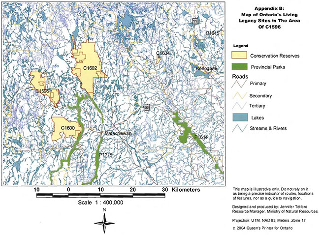
Enlarge Map of Ontario’s Living Legacy Sites in the Area of C1596
Appendix C: Wildlife Management Area’s in C1596
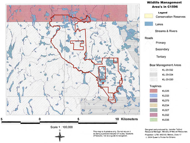
Enlarge Map of Wildlife Management Area’s in C1596
Appendix D: C1596 Wildlife areas
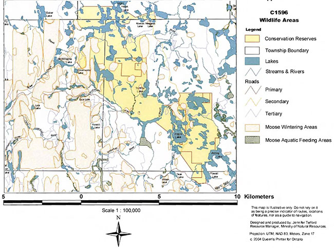
Enlarge Map of C1596 Wildlife Areas
Appendix E: Whitefish River Sandy Till Conservation Reserve fact sheet
September 2000
Background
On July 16, 1999, the Ontario Government released the Ontario’s Living Legacy Land Use Strategy to guide the planning and management of Crown lands in central and northern Ontario. A major part of the Ontario’s Living Legacy Land Use Strategy was a government intent to establish 378 new protected areas. This commitment marks the biggest expansion of provincial parks and conservation reserves in Ontario’s history. The proposed Whitefish River Sandy Till Conservation Reserve is part of this significant expansion of Ontario’s protected areas system.
Size and location
The Whitefish River Sandy Till Conservation Reserve consists of 3873 hectares located in the townships of Argyle, Baden, Cleave and McNeil. It is located partially in both the Timmins and Kirkland Lake Districts.
Area highlights
Contained within this site is strongly broken deep and shallow sandy till with relief, and bare bedrock which is located along the site’s western and southern boundaries. Towards the center of the site lacustrine deposits and wetlands and much flatter topography exist. This site is dominated by 31 to 100 year old black spruce, 31 to 70 year old jack pine and young (<30 year old) white birch. Old growth black spruce, white cedar and poplar aspen are also prevalent on the site. Scattered white pine also occurs. A waterfowl staging area is present in this site in McNeil Twp.
Land Use intent
Conservation reserves are areas of Crown land set aside by regulation under the Public Lands Act. Conservation reserves complement provincial parks in protecting representative natural areas and special landscapes. Most recreational (e.g. hiking, skiing, tourism related uses, nature appreciation) and non-industrial (e.g. fur harvesting, commercial fishing and bait fishing) activities that have traditionally been enjoyed in the area will continue, provided that these uses do not impact on the natural features needing protection. Hunting and fishing are permitted within all new conservation reserves proposed through Ontario’s Living Legacy. Commercial timber harvesting, mining, aggregate extraction and commercial hydroelectric development are prohibited in conservation reserves. Careful mineral exploration may occur in specific new conservation reserves proposed through Ontario’s Living Legacy, in areas that have provincially significant mineral potential. If a portion of a new conservation reserve is to be developed for a mine, it would be removed from the reserve, and appropriate replacement lands would be placed in regulation.
Next steps
The Land Use Strategy established the Ministry’s intent to add these Crown lands to Ontario’s protected areas system, following the extensive public consultation associated with the Ontario’s Living Legacy and Lands for Life land use planning initiatives between 1997 and 1999. Prior to the finalization of the boundary of this conservation reserve proposed for regulation under the Public Lands Act, the Ministry is inviting public comment on the proposed boundary from all potentially affected stakeholders and First Nations. In the interim, the area has been withdrawn and protected from resource extraction activities such as timber harvesting, hydroelectric development, aggregate extraction and new mineral exploration. In the future and subject to the intended regulation of the area as a conservation reserve, the Ministry of Natural Resources will prepare a long term management plan for this area. Depending upon the complexity of issues within this conservation reserve, management planning and may take the form of a simple Statement of Conservation Interest or a more detailed Resource Management Plan. Please let us know if you would like to be notified when planning begins. Planning, management and the uses permitted within this conservation reserve would be consistent with the commitments of the Ontario’s Living Legacy Land Use Strategy.
For more information
For further information on the proposed Whitefish River Sandy Till Conservation Reserve, please contact:
Shaun Walker, District Planner Ministry of Natural Resources Kirkland Lake District
phone: 705-568-3231, email: shaun.walker@mnr.gov.on.ca [inactive]
You may also visit the Ministry’s website for information on Ontario’s Living Legacy.
Appendix 4: Procedural Guideline B
Land Uses - Test of Compatibility (PL Procedure 3.03.05)
The Conservation Reserve policy provides broad direction with regard to the permitted uses. The policy provides only an indication of the variety of uses that will be considered acceptable in Conservation Reserves. The only caution is that “any new uses, and commercial activities associated with them, will be considered on a case by case basis and, they must pass a test of compatibility to be acceptable.”
What does a "test of compatibility" mean? An examination of this must start from the premise of why an area is set aside - specifically, its representative natural heritage values. Criteria are then identified to guide compatibility considerations. These criteria apply to the long-term acceptability of both existing uses and new uses.
-
Conformity to SCI/RMP: SCI describes values for which an area has been set aside and the range of appropriate uses that will be permitted in the area. SCI may also speak to the acceptability of other “new” uses currently not occurring in the area.
The first ‘test’ is: “do proposed new land uses and/or commercial activities conform to the direction of the SCI/RMP for the Conservation Reserve? Would the new use(s) depart from the spirit of appropriate indicator land uses in the SCI/RMP?”
- Impact Assessment: If the proposed use(s) pass test 1 it is important to determine their impact on the area before they are approved. This should include the following:
- Impact on natural heritage values: “will the new use(s) impact any natural values in the area? If so, how and to what degree? Is it tolerable?”
- Impact on cultural values: “will the new use(s) impact any historical or archaeological values in the area?“
- Impact on research activities: “will the new use(s) affect research activities in the area?”
- Impact on current uses: “will the new use(s) have any negative impact on the array of current uses?”
- Impact on area administration: “will the new use(s) increase administrative cost and/or complexity?” (For example, the cost of area monitoring, security or enforcement).
- Impact on accommodating the use outside the Conservation Reserve: “Could the use(s) be accommodated as well or better outside the Conservation Reserve?”
- Impact on socio-economics of the area: “will the new use(s) affect the community (ies) surrounding the area in a positive or negative way?” (For example, will the new use make an area less remote thereby affecting a local tourism industry that is dependent on the area’s remoteness for its appeal?).
- Impact on area accessibility: “does the new use(s) give someone exclusive rights to the area or a portion of the area to the exclusion of other existing uses?”
Appendix 5: Procedural Guideline C
Research activities in Conservation Reserves
Purpose
To encourage contributions to the goal of conservation reserves by:
- Providing direction for research activities associated with conservation reserves: and
- Establishing a process for the review and approval of proposals by researchers, which could have an impact on the values protected by the conservation reserve
Definition
Research means any investigation or study of the natural, cultural, social, economic, management or other features of characteristics of conservation reserves.
Guidelines
Research will be encouraged to provide a better understanding of the natural values protected by a conservation reserve and to advance their protection, planning and management. The Statement of Conservation Interest will define, for each conservation reserve, the key research issues, set out the parameters within which research may occur and identify research needs.
Applications and approvals
Researchers must apply in writing to the Area Supervisor for permission to conduct research. The request letter must contain a statement explaining why the proposed research should be undertaken in the particular conservation reserve in preference to another location.
Proposals will be reviewed and approved by the Area Supervisor, guided by the Statement of Conservation Interest prepared for each reserve (See Guideline A Resource Management Planning) and using Guideline B-Land Uses- Test of Compatibility. Permission must be granted in writing, including any conditions to be met in conducting the research, prior to the undertaking of any research project.
Terms and conditions
Permission to conduct research under this policy will be valid for a period of 12 consecutive months from date of issue. Permission to continue a research project for additional periods of 12 months or less may be granted upon submission of a written request and progress report. The Ministry may require the posting of collateral to assure that the terms and conditions of granting permission are to be met.
The Area Supervisor may suspend or revoke permission at any time for failure on the part of the researcher to meet:
- The intent or conditions of this policy
- The requirements under the Public Lands Act, including all amendments, where applicable
- The requirements under any other Act or Regulations or Ontario or Canada, including those governing the taking, handling, storing, confining, trapping, excavating and marketing any specimen, artifact, information or action (for example, scientific collector’s permit)
- The conditions and agreements specified in granting permission
Final report
The researcher will submit copies of reports, publications and theses following from the results of the project to the Area Supervisor.
Appendix 6: Crown Land Use Atlas
Policy report
C1596
Whitefish River Sandy Till
Updated: June 29, 2004
Identification:
ID: C1596
Area Name: Whitefish River Sandy Till
Area (ha): 3,834
Designation: Conservation Reserve - Recommended (Ontario’s Living Legacy)
MNR District(s): Kirkland Lake, Timmins
Description:
Contained within this site is strongly broken deep and shallow sandy till with relief, and bare bedrock which is located along the site’s western and southern boundaries. Towards the center of the site lacustrine deposits and wetlands and much flatter topography exist. This site is dominated by 31 to 100 year old black spruce, 31 to 70 year old jack pine and young (<30 year old) white birch. Old growth black spruce, white cedar and poplar aspen are also prevalent on the site. Scattered white pine also occur. A waterfowl staging area is present in this site in McNeil Township.
Land use intent:
The intent is to regulate this area as a conservation reserve.
Management of this area is also governed by the general policies contained in the Land Use Strategy (1999).
Management direction:
Those uses and management activities not listed in the following table are governed by existing conservation reserve policy. Over time the management direction will be elaborated in a Statement of Conservation Interest or Resource Management Plan. Any new uses, and commercial activities associated with conservation reserves, will be considered on a case by case basis, and they must pass a test of compatibility to be acceptable. Compatibility is normally determined through a planning process.
| Activity | Permitted | Guidelines |
|---|---|---|
| Aggregate Extraction | No | N/A |
| Bait Fishing - Existing | Yes | Existing use permitted to continue, unless there are significant demonstrated conflicts. |
| Bait Fishing - New | Maybe | New operations can be considered, subject to the "test of compatibility" |
| Commercial Fishing - Existing | Yes | Existing use permitted to continue, unless there are significant demonstrated conflicts. |
| Commercial Fishing - New | Maybe | New operations can be considered, subject to the "test of compatibility". |
| Commercial Fur Harvesting - Existing | Yes | Existing use permitted to continue, unless there are significant demonstrated conflicts. Existing trap cabins can continue; new cabins are not permitted. |
| Commercial Fur Harvesting - New | Maybe | New operations can be considered, subject to the "test of compatibility". |
| Commercial Hydro Development | No | N/A |
| Commercial Timber Harvest |
No | N/A |
| Commercial Tourism - Existing | Yes | Existing authorized facilities can continue, unless there are significant demonstrated conflicts. |
| Commercial Tourism - New | Maybe | New tourism facilities can be considered during the planning for an individual reserve. |
| Bear Hunting by Non residents (guided) - Existing | Yes | Existing authorized operations permitted to continue. |
| Bear Hunting by Non residents (guided) - New | No | New operations not permitted. |
| Outfitting Services - Existing | Yes | Existing authorized operations permitted to continue. |
| Outfitting Services - New | Maybe | New operations can be considered during the planning for an individual reserve. |
| Outpost Camps - Existing | Yes | Existing authorized facilities permitted to continue. |
| Outpost Camps - New | Maybe | New facilities can be considered during the planning for an individual reserve. |
| Resorts/lodges - Existing | Yes | Existing authorized facilities permitted to continue. |
| Resorts/lodges - New | Maybe | New facilities can be considered during the planning for an individual reserve. |
| Energy Transmission and Communications Corridors - Existing | Yes | These facilities should avoid conservation reserve lands wherever possible. |
| Energy Transmission and Communications Corridors - New | No | N/A |
| Food Harvesting (Commercial) - Existing | Maybe | N/A |
| Food Harvesting (Commercial) - New | Maybe | N/A |
| Mineral Exploration and Development | No | N/A |
| Peat Extraction | No | N/A |
| Wild Rice Harvesting - Existing | Yes | N/A |
| Wild Rice Harvesting - New | Maybe | N/A |
Land and resource management activities
| Activity | Permitted | Guidelines |
|---|---|---|
| Crown Land Disposition Private Use: | Maybe | N/A |
| Crown Land Disposition Commercial Use: | Maybe | Sale of lands is not permitted, except for minor dispositions in support of existing uses (e.g. reconstruction of a septic system). Renewals of existing leases and land use permits are permitted. Requests for transfer of tenure will be considered in the context of the Statement of Conservation Interest or Resource Management Plan. New leases or land use permits permitted for approved activities. Tourism facilities can apply to upgrade tenure from LUP to lease. |
| Fire Suppression | Yes | Fire suppression policies are similar to adjacent Crown lands, unless alternative fire policies have been developed through a planning process. |
| Fish Habitat Management | Maybe | N/A |
| Fish Stocking | Maybe | Existing authorized operations permitted to continue. New operations not permitted. |
| Inventory/disease Suppression | Maybe | N/A |
| Inventory/Monitoring | Maybe | N/A |
| Prescribed Burning | Maybe | N/A |
| Roads (Resource Access) - Existing | Yes | N/A |
| Roads (Resource Access) - New | Maybe | Existing roads can continue to be used. Continued use will include maintenance and may include future upgrading. New roads for resource extraction will not be permitted, with the exception of necessary access to existing forest reserves for mineral exploration and development. |
| Vegetation Management | Maybe | Conservation Reserves policy indicates that Featured Species Management and Natural Systems Management may be permitted. Vegetation management can be considered in a planning process. |
| Wildlife Population Management | Maybe | N/A |
Science, education and heritage appreciation
| Activity | Permitted | Guidelines |
|---|---|---|
| Collecting | No | N/A |
| Historical Appreciation | Yes | N/A |
| Nature Appreciation | Yes | N/A |
| Photography and Painting | Yes | N/A |
| Research | Yes | N/A |
| Wildlife Viewing | Yes | N/A |
Recreation activities and facilities
| Activity | Permitted | Guidelines |
|---|---|---|
| All Terrain Vehicle Use On Trails: | Yes | Existing use permitted to continue where it does not adversely affect the values being protected. ATV use off trails is not permitted except for direct retrieval of game. |
| All Terrain Vehicle Use Off Trails: | No | N/A |
| Campgrounds | Maybe | N/A |
| Food Gathering | Yes | N/A |
| Horseback Riding (trail) | Yes | Existing use on trails permitted. |
| Hunting | Yes | N/A |
| Mountain Bike Use | Yes | Existing use on trails permitted. |
| Motor Boat Use Commercial: | Yes | N/A |
| Motor Boat Use Private: | Yes | N/A |
| Non-motorized Recreation Travel | Yes | N/A |
| Private Recreation Camps (Hunt Camps) - Existing | Yes | N/A |
| Private Recreation Camps (Hunt Camps) - New | No | Existing camps permitted to continue, and may be eligible for enhanced tenure, but not purchase of land. |
| Rock Climbing | Maybe | N/A |
| Snowmobiling On Trails: | Yes | Existing use permitted to continue where it does not adversely affect the values being protected. |
| Snowmobiling Off Trails: | Maybe | Snowmobile use off trails is not permitted, except that snowmobiles may be used for direct retrieval of game. |
| Sport Fishing | Yes | N/A |
| Trail Development - Existing | Yes | Development of trails for a variety of activities (e.g. hiking, cross-country skiing, cycling, horseback riding, snowmobiling) can be considered as part of planning for an Individual reserve. |
| Trail Development - New | Maybe | N/A |
Note: The policies outlined in this table do not supersede any Aboriginal or treaty rights that may exist, or other legal obligations.
Management of this conservation reserve is carried out within the context of Conservation Reserve policy as amended by the policies for new conservation reserves outlined in the Ontario’s Living Legacy Land Use Strategy.
Source of direction
Ontario’s Living Legacy Land Use Strategy (1999)
Conservation Reserves Policy (1997)
Explanation of edits
Area calculation has been edited based on current mapping. Area calculations are preliminary until public consultation on boundaries has been completed and the area has been regulated.
Appendix 7: Locator map
Appendix 7: Whitefish River Sandy Till Conservation Reserve (C1596) Locator map
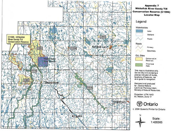
Enlarge Whitefish River Sandy Till Conservation Reserve (C1596) Locator Map
Appendix 8: Natural heritage life science checksheet
- Name: C1596 Whitefish River Sand Till CR
- Map Name: Raddisson Lake
- Map Number: 42A/02
- UTM reference: 508532
- Locality: Timiskaming
- Latitude: 48°03′41″ N
- Longitude: 80°53′47″ W
- NAD: 83 CNT
- Minimum Altitude: 320 m
- Maximum Altitude: 360 m
- Township: Cleaver, McNeil, Hincks, Argyle, Bannockburn
- Area: 3399 ha (+ 435 ha forest reserve)
- Ownership: Crown
- MNR Region: Northeast
- MNR District: Kirkland Lake /Timmins
- Ecoregion and Ecodistrict: 3E-5 (Hills 1959 & Crins & Uhlig 2000)
- Landform Unit(s) (preliminary):
9 Organic deposits
8 Alluvial deposits
7 Eolian deposits (parabolic sand dunes)
6 Glaciolacustrine deposits or
5 Glaciofluvial outwash deposits
4 Ice-contact stratifieddrift deposits
2 Bedrock-Drift complex - unsubdivided - Aerial Photograph: - Flight Line- Roll- Numbers
94-4804-29-15 to 16
86-4803-04-72 to 74
86-4802-04-09 to 11
86-4801-04-144 to 146
Map: C1596 Whitefish River Sandy Till Upland CR, Natural Heritage Area - Life Science Checksheet
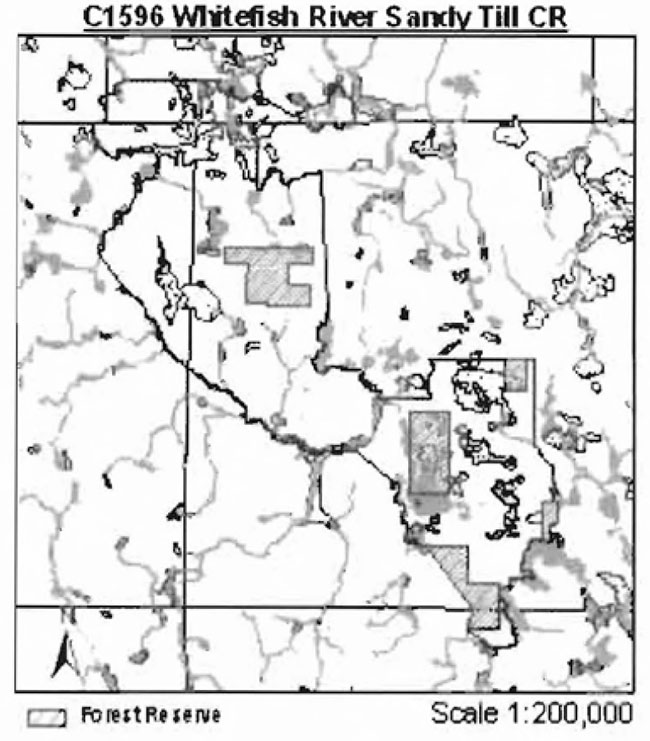
Physical and biological features
Representation
Whitefish River Sandy Till Conservation Reserve (CR) is located in both Timmins and Kirkland Lake MNR Districts with Kirkland Lake assuming the responsibility of the site. It lies in Cleaver, McNeil, Hincks, Argyle and Bannockburn Townships and is 3834 hectares in size. It is comprised of vectored, biological and cultural boundaries. The nearest town is Matachewan, approximately 18 kilometres southeast of the CR. Access to the site can be achieved by using Highway 566 from Matachewan and then using Argyle Lake Road on the east side, Argyle Lake Lodge Road at the south end and Austen Lake and Sawmill Roads on the west side. According to the OLL Land Use Strategy (1999), the CR contains strongly broken deep and shallow sandy till with relief and bare bedrock which is located along the western and southern boundaries. Towards the center are lacustrine deposits and wetlands and a much flatter topography. The site is dominated by 31-100 year old black spruce, 31-70 year old jack pine and young white birch. Old growth black spruce, white cedar and aspen with some scattered white pine are present. A waterfowl staging area is present in McNeil township. After the aerial reconnaissance survey, it was determined these landforms are not present as indicated and dominant forest communities have a greater age range.
The conservation reserve is located in ecodistrict 3E-5 (Foleyet) of the ecoregion 3E (Lake Abitibi). The ecodistrict is characterized by gently rolling plains with thinly covered rock knobs, sandy outwash and silty depressions. Materials are generally granitic, locally overlain by low-base and low-lime materials. Deep deposits cover 25% of the area and the remaining areas have very shallow deposits (Keddy 1997). With the close association with ecoregion 4E and the Great Lakes-St. Lawrence forest, some sporadic occurrences of species having southern affinities, such as yellow birch, sugar maple and white pine, are present. The ecoregion, also called the Central Boreal Forest Region, is characterized by flat to gently rolling, glacial clay and sandplain with locally extensive peatlands and wetlands, broken throughout by glacial features such as moraines, eskers with Canadian Shield exposure. Regional vegetation includes spruce, poplar, and birch on fresh sites on moderately sloping terrain, white and red pine on sand ridges and American elm and white cedar in protected areas. The forest climate type is mid-humid, mid-boreal (Poser 1992; Noble 1983).
There are several different landforms within this conservation reserve (Map 1b). Glaciofluvial ice-contact deposits located from Neegeek Lake through to Argyle Lake, till in the center of the CR, bedrock on the southeast corner and north portion, and organic deposits in the mid-center are present according to the quaternary geology of Ontario layer. NOEGTS (Northern Ontario Engineering Geology Terrain Study) (Lee 1979) in many cases had similar boundaries as the quaternary geology coverage but different interpretations. In speaking with Rik Kristjansson, OLL Geologist (2004), the NOEGTS is fairly correct. The southeast corner from Powell Lake northwards contains excellent examples of parabolic sand dunes (unit 7) surrounded by organic deposits. An esker system (unit 4) runs through the Argyle Lake area in a north-south direction. Minor areas of 5 or 6 (undecided) are also present. The rest of the south half consists of extensive areas of unit 2 with some bedrock outcrops. Sandy alluvial deposits are associated with the floodplains of Whitefish River and McCollum Creek with some organic deposits. The north half is dominated by extensive areas of unit 2, some areas of planar sand (unit 5 or unit 6), extensive and local organic deposits. Other features of the north half include a small esker system around Neegeek which is not as prominent as the south one and one on the west side and parabolic sand dunes complex forming a ridge on the west side.
The area is in Rowe’s (1972) B.7 section (Missinaibi-Cabonga) of the Boreal Forest Region. This section is along the height of land in central Ontario and the bulk of the forest is boreal but also contains within as scattered individuals or isolated patches species from the Great Lakes-St. Lawrence Forest. The predominant forest is mixed consisting of balsam fir, black spruce and white birch with scattered white spruce and trembling aspen. Jack pine on sand terraces and can also associate with black spruce on poor, rocky soils. Black spruce with tamarack covers wet organic soils and with cedar other lowlands. The topography is rolling with numerous flats along the rivers and lake sides.
The site is dominated by treed muskeg (28.3% of the total area) but treed muskeg is comprised of a mix of semi-treed bog, treed bog and a complex of meadow marsh, shore fen and treed fen (Map 2a, Appendix 2). The dominant forest communities are Pj dominant conifer
Old growth (Map 5), based on Bridge et al (2000) criteria and standard forest units (SFU), were found in the majority of the Ce dominated stands and many of the tamarack and black spruce stands in association with the treed muskeg areas. Two stands southwest of Tomfox Lake were candidate old growth but they have been recently harvested. Many more of the forest communities around the treed muskeg areas are probably old growth and older than reported in the FRI. Only ground-truthing would verify this assumption.
Forest communities were re-classified to standard forest units (SFU), a more ecological approach to naming forest communities (Map 2d, Appendix 2). After treed muskeg, the site is dominated by SB1 (black spruce lowland (17.2% of the total area)), PJ1 Jack pine (11.1%)), SP1 (spruce pine (8.2%)) and BW1 (birch poplar (8.1%)). Of the 14 SFU’s, only 2 were less than 1% in total area. SB1 incorporated most of the Sb dominated stands except those that contained tamarack and cedar which then became LC1 or black spruce site class 4 which became BOG. PJ1 incorporated the majority of the Pj dominated stands and were associated with sand dunes or bedrock-drift complex. Other SFU’s include MW2 (spruce fir mixed), MW1 Jack pine mixed), P01 (poplar), PJ2 (pine spruce) and SF1 (spruce fir).
Wetlands
The extreme north end of the conservation reserve is located in the tertiary watersheds of 4MD and 4LA of the Moose River major basin and the rest of the site in tertiary watershed 2.10 of the Ottawa River major basin (OMNR 2002). All the waterbodies in the area are clear and dark in colour. Headwaters are abundant in the area including several creeks to McCollum Creek and Ashley Lake system and several systems feeding Whitefish River. Fish species are generally coolwater species including northern pike and walleye and mostly likely yellow perch (Map 3a).
Other values (Map 3a) include traplines KL026, KL033 and KL079 and bear management areas KL-29-032 and KL-29-034. The conservation reserve also contains many pockets of moose early wintering and late wintering areas usually wherever there is good stocking of conifer species such as black spruce and cedar. Several of the waterways, such as McCollum Creek and Whitefish River, contain marsh plants suitable for moose aquatic feeding areas. Osprey and great blue heron nest around Tomfox Lake although nests were not observed during the aerial reconnaissance.
Condition
Condition
Natural disturbance has been restricted to trembling aspen which has been attacked by eastern tent caterpillar in the last few years. Many trees have survived but many are in poor shape with a reduced leaf cover.
Diversity
Diversity is a measure of the site’s life and earth science heterogeneity. It is based on the number and range (variety) of the natural landscape features and landforms for earth science values and the relative richness and evenness of the site’s life science components. Based on the analysis done by Ontario Parks (2003), there are 32 landform:vegetation (L:V) combinations, of which 13 account for <1% of the total area. Forest reserves were removed from this analysis. The largest combinations were mixed coniferous forest on bedrock (19.89% of the total area}, sparse coniferous forest on bedrock (9.77%) and dense coniferous forest on bedrock (9.18%). With SFU’s and Kristjansson’s different interpretation of the landforms, the diversity rating
Besides SFU’s, development stages will add to the diversity. All of the SFU’s (except for MW1) are represented by immature and mature forest communities with some old growth in SB1, SP1 and LC1. Wetlands also add to the diversity. The 3 FRI wetlands are represented by shore fens, meadow marsh, semi-treed bog, treed bog, poor fen and open water marsh. As well, some the forest communities are classified as treed fen, treed bog and conifer swamp. Dispersion is another consideration in diversity. For this conservation reserve, there is good dispersion of all of the SFU’s in the northwest half but in the southeast, dispersion is low. This half is predominantly represented by PJ1 and SB1.
Evenness
Ecological considerations
Whenever possible, a site’s boundaries should be created to include the greatest diversity of life and earth science features to provide the maximum ecological integrity. It should be ecologically self-contained, bounded by natural features and include adequate area to buffer the core ecosystems from intrusive influences (OMNR 1992). This site is bounded mostly by biological borders including McCollum Creek, Tomfox Lake, East Whitefish Lake and Neegeek Lake. Cultural boundaries such as Highway 566 on the south side and Argyle Lake Road were used. The rest of the boundaries are vectored. The site also contains several mining claims which may be deleted in the future and potentially new areas can be assigned to the conservation reserve. The projection in McNeil township in the Neegeek Lake is the poorest designed portion of the CR. The narrowest section is approximately 200 meters wide and the area consists of many vectors (including township line). There is little protection to the forest communities if any activities occur outside the CR and the boundaries were not properly marked. To make it more ecologically sound, the area south of Neegeek Lake to the unnamed creek with the road acting as the east boundary should be included into the CR (see Appendix 1- Ecological Considerations). There are no natural features in the north to use to replace the vectored boundary. The vectored boundary in the Argyle Creek area could be replaced using the trail and creek centerlines to Whitefish River.
Currently we do not have minimum size standards for conservation reserves under different landscape conditions. However, a minimum size standard of 2000 ha has been established for natural environment parks by Ontario Parks (OMNR 1992). This minimum standard was considered necessary to protect representative landscapes as well as allow for low intensity recreational activities. This conservation reserve has met the minimum standard at 3834 hectares. The size provides adequate protection from any intrusive influences on the core ecosystem (wetlands, black spruce, jack pine and white birch forests, etc.). The many biological boundaries limit the amount of trespassing that can occur. Without the existing trails and roads within the site, the amount of recreational activity is limited by the large wetland complexes occurring throughout.
Special features
One of the special features of this conservation reserve is the excellent example of parabolic sand dunes with its associating black spruce and/or jack pine forest communities and the surrounding wetlands, usually semi-treed bog and/or treed bog. Another special feature is the good representation of the different forest communities. Only white and red pine and tolerant hardwood stands are mixing from the site.
Major information sources
Arnup, R., G.D. Racey and R.E. Whaley. 1999. Training manual for photo interpretation of ecosites in northwestern Ontario. NWST Technical Manual TM-003.127p.
Bridge, Simon; Watt, Robert; Lucking, Greg; and Brian Naylor. 2000. Landscape analysis for forest management planning in boreal northeastern Ontario. OMNR, Northeast Science & Technology. 36p.
Burkhardt, B.C. 2003. C1596 aerial reconnaissance notes.
Crins, W.J. and P. W. C. Uhlig. 2000. Ecoregions of Ontario: Modifications to Angus Hills’ Site Regions and Site Districts - Revisions and Rationale.
Harris, A.G., S.C. McMurray, P.W.C. Uhlig, J.K. Jeglum, R.F. Foster and G.D. Racey. 1996. Field guide to the wetland ecosystem classification for northwestern Ontario. Ont. Min. Natur. Resour., Northwest Sci. & Technol. Thunder Bay, Ont. Field Guide FG-01. 74 pp. + append.
Hills, G.A. 1959. A Ready Reference to the Description of the Land of Ontario and its Productivity.
Keddie, C. 1997. Natural Heritage Gap Analysis for Site District 3E-5: GIS Analysis. by Geomatics International Inc.
Kristjansson, R. 2004. Personal Conversation.
Lee, Hulbert A 1979. Northern Ontario Engineering Geology Terrain Study, Data Base Map, Kirkland Lake. Ontario Geological Survey, Map 5030, Scale 1:100 000.
Noble, T.W. 1983. Central Boreal Forest Region (3E). Life Science Report. Northeastern Region. Internal report. Ontario Ministry of Natural Resources. 2002. MNR Districts and Major Basins of Ontario.
Ontario Ministry of Natural Resources. 1999. Ontario’s Living Legacy Land Use Strategy.
Ontario Ministry of Natural Resources. 1992. Ontario Provincial Parks: Planning and Management Policies-1992 Update.
Ontario Parks. 2003. Landform Vegetation Representation Summary for site C1596 in Ecodistrict 3E-5. (May 2003). Internal Report
Rowe, J.S. 1972. Forest Regions of Canada. Department of Fisheries and the Environment-Canadian Forestry Service Publication No. 1300. 172p.
Taylor, K.C., R.W. Arnup, B.G. Merchant, W.J. Parton and J. Nieppola. 2000. A field guide to forest ecosystems of Northeastern Ontario. 2nd Edition. Northeast Science and Technology NEST Field Guide FG-001.
Thompson, John E. & Jake Noordhof. 2003. Edit Model for N.E. Region Life Science Checksheets. Internal Report.
Uhlig, P., A Harris, G. Craig, C. Bowling, B. Chambers, B. Naylor and G. Beemer. 2001. Old growth forest definitions for Ontario. Ont. Min. Nat. Res., Queen’s Printer for Ontario, Toronto, ON. 53p.
Significance level (provincial/regional/local) and brief summary of major representative values
In a gap analysis conducted for the MNR in 1997, at least 20 biophysiographic units (equivalent to landform:vegetation combinations) such as black spruce, white birch and jack pine on weakly broken outwash plains (lacustrine) were represented in the candidate area of 5073 hectares (Keddie 1997). Of these 20, 14 were the only contribution to the ecodistrict with 1 unit being unique to the whole ecodistrict. Whether this unit at 11.5 hectares is provincially significant is unknown since no mapping products are available to determine if this is just an overlap sliver.
The OLL Land Use Strategy (1999) states C1596 contains strongly broken deep and shallow sandy till with relief, bare bedrock, lacustrine deposits and wetlands with a range of ages of black spruce, jack pine and white birch. The significance of this conservation reserve needs to be re-visited based on the landforms that are present. In conversation with Rik Kristjansson, the site does not contain any mappable till and is dominated by bedrock-drift complex with the odd bedrock outcrops. Sand deposits, other than the sand dunes (eolian deposits), were either glaciolacustrine or glaciofluvial in origin. Wetlands form a predominant factor in the site. Forest communities are dominated by black spruce (45-155 years of age), jack pine (22 -100 years) and white birch (75-90 years).
The regulated boundary has not change significantly from the original blue lines (Appendix 1 - History map) so that any features that were originally trying to be captured are still in the current conservation reserve.
Sensitivity
The most sensitive feature of the site would be the treed muskeg areas, particularly to motorized vehicles. The many biological boundaries protects much of the conservation reserve from any intrusive influences such as harvesting, road construction and gravel extraction.
Recommendations
- This second step checksheet should be advanced to a fourth step by digitizing the earth science data based on Kristjansson’s interpretations of aerial photos, once these become available and used with SFU to complete a current landform:vegetation analysis. Finally, the checksheet could be advanced to a fifth step by comparing the fourth step checksheet with the current provincial landform layers based on the new regulated boundary to see if comparisons can be made. In turn we can determine more fully the site’s significance and contribution to the parks and protected areas program.
- The vectored boundaries for the site should be marked to ensure that the values within the site are protected from surrounding land use activities. Further analysis and assessment may require additional management prescription to ensure long term protection of the site’s natural heritage values.
- On ground age analysis of the jack pine and black spruce stands to determine if more old growth exists.
- Alter some of the vectored boundaries to create more ecological boundaries as indicated in the Ecological Considerations map (Appendix 1) and to reduce the risk of any trespassing.
- Funding should be secured in the near future to determine the number and location of roads and trails currently present within the site using current global positioning technologies.
- Any future trail development must consider the values found within the boundaries of the site, the rationale for developing trails within the site and the availability of current access through the site and surrounding areas. Furthermore, any new trail development will require a “Test of Compatibility”. Low-lying areas and wetlands should be avoided.
- Overall custodial management is the responsibility of the district office with support from the regional natural heritage specialist and Ontario Parks. To advance conservation reserve custodial management, future managers will need to monitor the current state of the CRs resources at least at the community and landscape levels within and adjacent to the conservation reserve and its surrounding environment. Such monitoring could include: evaluating and reporting on changes such as; natural disturbances (ie. fire, insect/disease, wind throw, etc.), human disturbances (ie. forest harvesting, access and/or other land use activities) as well as management prescriptions (ie. rehabilitation efforts and/or vegetative management planning).
- Ongoing evaluations and reports will have to rely on current and new technologies such as satellite imagery, global positioning systems (GPS), supplementary aerial photography (SAP) and/or aerial/ground reconnaissance surveys/assessments conducted periodically and placed within a GIS database. Such tools could help managers spatially record areas affected severity of perturbations or management action as well as consider the sensitivity of values, the design of CR and determine the future desired condition of the site. Monitoring efficiencies could be enhanced via partnerships and internal coordination within MNR.
footnote 8
Time effort spent on site
September 23/03 12:30-1:30
Date compiled
March 1, 2004
Compiler(s)
Barbara Burkhardt, Lori King, Sean Longyear
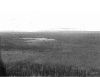
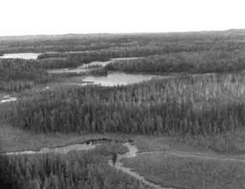
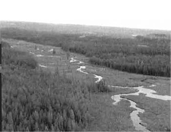
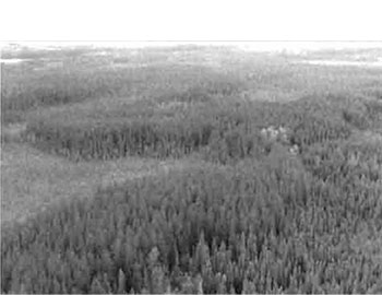
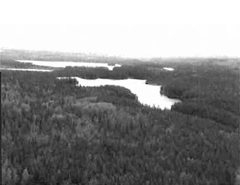
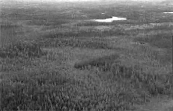
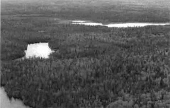
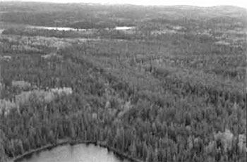
Map 1: Surficial Geology, C1596 Whitefish River Sandy Till CR
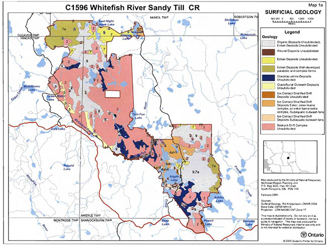
Enlarge Map 1: Surficial Geology, C1596 Whitefish River Sandy Till CR
Map 2: Geology, C1596 Whitefish River Sandy Till CR
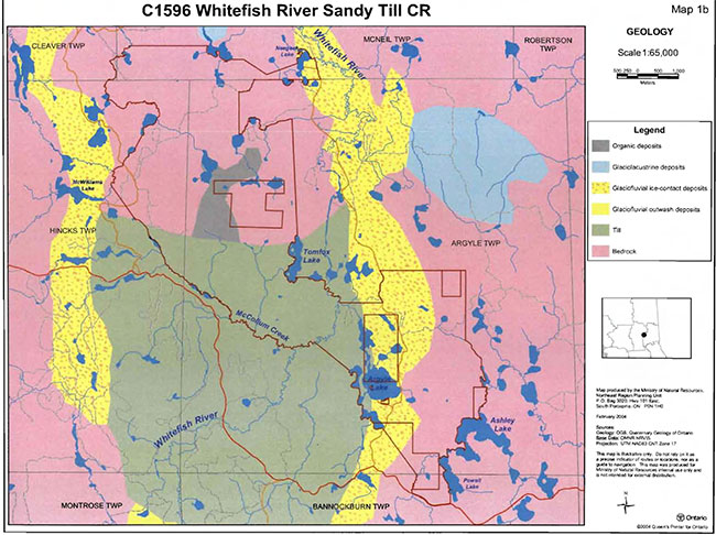
Enlarge Map 2: Geology, C1596 Whitefish River Sandy Till CR
Map 3: Forest Communities, C1596 Whitefish River Sandy Till CR
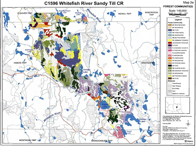
Enlarge Map 3: Forest Communities, C1596 Whitefish River Sandy Till CR
Map 4: Stocking Distribution, C1596 Whitefish River Sandy Till CR
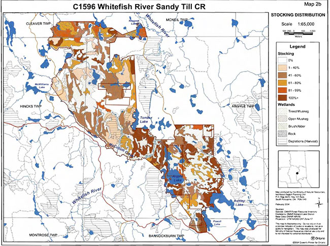
Enlarge Map 4: Stocking Distribution, C1596 Whitefish River Sandy Till CR
Map 5: Age Distribution, C1596 Whitefish River Sandy Till CR
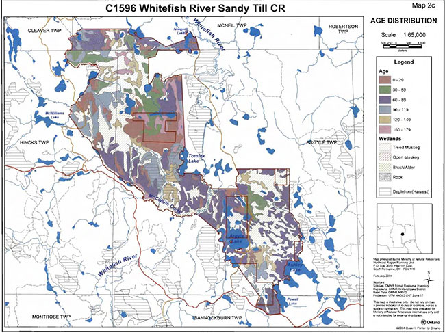
Enlarge Map 5: Age Distribution, C1596 Whitefish River Sandy Till CR
Map 6: Standard Forest Units, C1596 Whitefish River Sandy Till CR
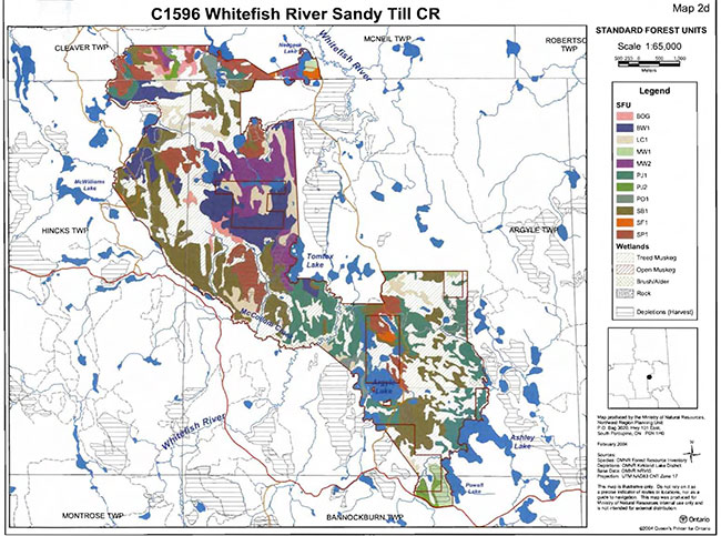
Enlarge Map 6: Standard Forest Units, C1596 Whitefish River Sandy Till CR
Map 7: Values, C1596 Whitefish River Sandy Till CR
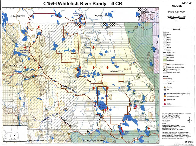
Enlarge Map 7: Values, C1596 Whitefish River Sandy Till CR
Map 8: Wetlands, C1596 Whitefish River Sandy Till CR
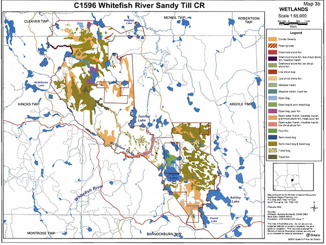
Enlarge Map 8: Wetlands, C1596 Whitefish River Sandy Till CR
Map 9: Old Growth, C1596 Whitefish River Sandy Till CR
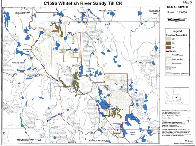
Enlarge Map 9: Old Growth, C1596 Whitefish River Sandy Till CR
Map 10: Ecological Consideration, C1596 Whitefish River Sandy Till CR (Part one)
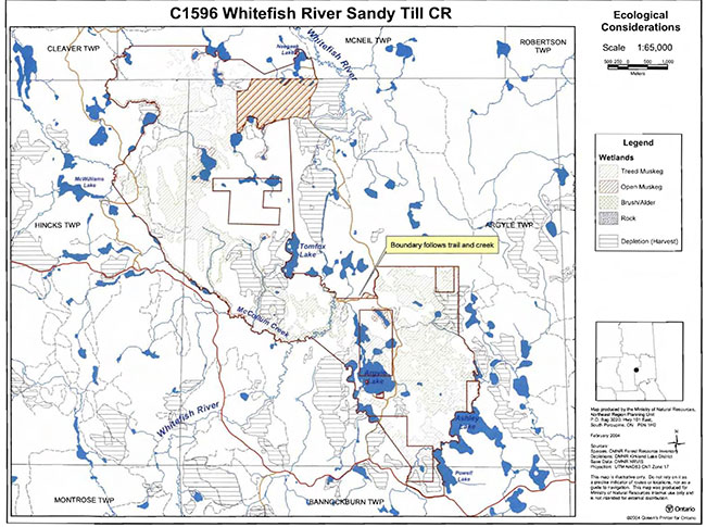
Enlarge Map 10: Ecological Consideration, C1596 Whitefish River Sandy Till CR (Part one)
Map 11: Ecological Consideration, C1596 Whitefish River Sandy Till CR (Part two)
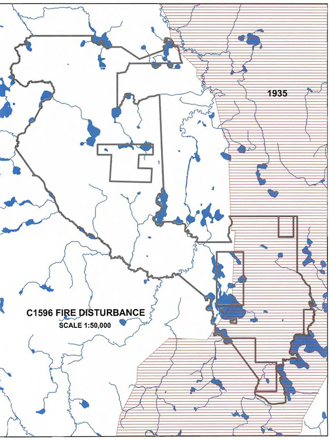
Enlarge Map 11: Ecological Consideration, C1596 Whitefish River Sandy Till CR (Part two)
Map 12: History, C1596 Whitefish River Sandy Till CR
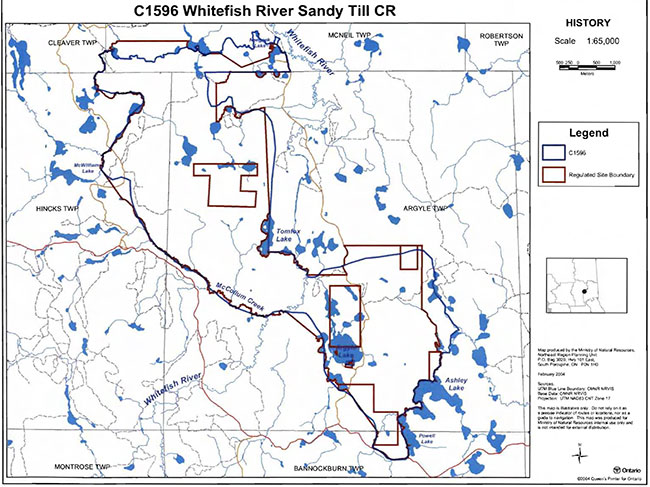
Enlarge Map 12: History, C1596 Whitefish River Sandy Till CR
Ministry of Natural Resources and Forestry
Appendix 9: Earth science checksheet
Whitefish River Sandy Till Conservation Reserve (C1596)
Approved Earth Science Checksheet
Kirkland Lake and Timmins
February 2, 2005
Prepared by:
F.J. (Rik) Kristjansson
Earth science inventory checklist
- Name: Whitefish River Sandy Till (C1596)
- Map Name: Raddisson Lake
- Map Number: 42 A/02
- UTM reference: 508532
- Latitude: 48°03′41″ N
- Longitude: 80°53′47″ W
- Elevation (Minimum): 320 m asl
- Elevation (Maximum): 360 m asl
- Locality: Timiskaming
- Township: Cleaver, McNeil, Hincks, Argyle, Bannockburn
- Area: 3399 ha
- MNR District: Kirkland Lake /Timmins
- MNR Region: Northeast
- Ecoregion and Ecodistrict: 3E-5 (Hills 1959 & Crins & Uhlig 2000)
- Aerial Photographs: Year- Flight Line- Roll- Numbers
86-02, 4804, 206 to 209
86-04, 4803, 71 to 75
86-04, 4802, 08 to 12
86-04, 4801, 143 to 145
Prepared by: F.J. Kristjansson, Consulting Geoscientist
Reviewed by: Phil Kor, Senior Conservation Geologist
Date: February 2, 2005
Earth science features
Bedrock Geology: Based on Map 2543 (Ontario Geological Survey, 1991), the Whitefish River Sandy Till Conservation Reserve is underlain by undifferentiated metavolcanic rocks of the Abitibi Subprovince, Superior Province, Precambrian Shield.
Surficial Geology: Based on a brief helicopter reconnaissance survey, review of terrain geological mapping (Lee, 1979, Data Base Map 5030), and interpretation of available aerial photography, the Whitefish River Sandy Till Conservation Reserve is immediately underlain by areas of Bedrock-Drift Complex (Unit 2), Ice-Contact Stratified Drift Deposits (Units 4ah, 4h, and 4), Glaciofluvial Outwash Deposits (Unit 5), Glaciolacustrine Deposits (Unit 6), Eolian Deposits (Units 7a and 7), Alluvial Deposits (Unit 8), and Organic Deposits (Units 9 and 9,7a). Please refer to the attached preliminary surficial geological mapping for the occurrence and distribution of these surficial geological units within the conservation reserve.
In planform, the conservation reserve has an unusual shape, and includes a large northwestern portion, a smaller southeastern portion, and a small, narrow, central portion.
Numerous areas immediately underlain by Bedrock-Drift Complex (Unit 2) are distributed throughout the northwest, southeast, and central portions of the conservation reserve. An extensive area of bedrock-drift complex, located in the northwest and central portions of the conservation reserve, is the most noteworthy. The morphology of the bedrock surface ranges from irregular, knobby areas with low local relief to bedrock knob (or knoll) areas with more moderate local relief. The extent of bedrock exposure ranges from minor to moderate, and the associated drift cover ranges, respectively, from thin, but relatively continuous to discontinuous. It is anticipated that the associated drift cover consists predominantly of till deposits. However, where areas of bedrock-drift complex are situated within, or immediately adjacent to, areas of ice-contact stratified drift deposits, glaciolacustrine deposits, or eolian deposits, the associated drift cover might include, or be dominated by, deposits of the indicated sediment type.
Various areas immediately underlain by Ice-Contact Stratified Drift Deposits (Units 4ah, 4h, and 4) are located in the southeastern and central portions of the conservation reserve (Photo. C1596-01), and in the extreme northeast part of the northwestern portion. These ice-contact stratified drift deposits are part of a more extensive esker-outwash fan system with significant deposits in the area located a short distance to the east of the northwestern portion of the conservation reserve.
A number of areas immediately underlain by Glaciofluvial Outwash Deposits (Unit 5) are situated along, or in the vicinity of, the southwest to central west boundary of the northwestern portion of the conservation reserve. Based on observations at two locations, these deposits, at least, in part, consist of gravelly sand. These glaciofluvial outwash deposits appear to be related to an esker-outwash fan system located a short distance to the west of the central west and northwest parts of the northwestern portion of the conservation reserve.
A number of areas immediately underlain by Glaciolacustrine Deposits (Unit 6) are present in the conservation reserve. A moderately extensive area, located in the south half of the southeastern portion of the conservation reserve, is perhaps the most noteworthy. It is anticipated that glaciolacustrine deposits in the conservation reserve consist predominantly of silty, fine sand, although deposits consisting of silt and clay might be present in some areas. Significant areas immediately underlain by Eolian Deposits (Units 7a and 7) are also present in the conservation reserve, in the southeastern portion and in the north half of the northwestern portion. Numerous, well-developed sand dunes are present in the central and central east parts of the southeastern portion of the conservation reserve (Photo. C1596-02), and in the northwest part of the northwestern portion (Photo. C1596-03). The formation of sand dunes requires the exposure of a sand source to wind activity. In this case, it appears that the sand source was initially emplaced as a glaciolacustrine deposit, which, following subaerial exposure, was extensively reworked by wind activity. Dune morphology appears to be dominated, if not exclusively represented, by variations of the parabolic form (David, 1979). Both glaciolacustrine deposits and eolian deposits are very likely related to the above-indicated esker-outwash fan systems, and are probably representative of the more distal, sandy portions of the outwash fans (i.e., subaquatic outwash fans). These deposits are thought to be representative of a probably short-lived, shallow glacial lake.
A well-developed alluvial plain, immediately underlain by Alluvial Deposits (Unit 8), is associated with the Whitefish River in the central portion of the conservation reserve (Photo. C1596-04). The marked meandering style of the Whitefish River, the numerous cut-off meander loops, and the obvious point bar development add considerably to the interpretive value of the conservation reserve.
The remaining areas of the conservation reserve, which include a relatively extensive area in the northwestern portion, a relatively extensive area in the southeastern portion, and numerous minor areas, are immediately underlain by Organic Deposits (Units 9 and 9,7a). The relatively extensive area in the southeastern portion of the conservation reserve, classified as Unit 9,7a, is the most noteworthy. Numerous, well-developed, sand dunes are associated with these organic deposits. From a landscape perspective, the juxtaposition of dune forms and peatlands is visually impressive (Photo. C1596-02).
Significance: With the exception of the numerous sand dune forms located east of Argyle Lake in the southeastern portion of the conservation reserve, the geological features described above are commonly encountered within the surrounding region and are considered to be of local significance. The indicated sand dune forms (Units 7a and 9,7a), due to their exceptional development, are considered to be of regional significance.
Sensitivity: Considering the relatively passive land uses anticipated within a conservation reserve (e.g., hunting), the various earth science features (with the exception of sand dunes and organic deposits) are considered to have low sensitivity. The sand dune forms depending on the vegetative cover can be sensitive even to passive activities such as hiking. Organic deposits (i.e., peatlands) may be sensitive to ATV or "All Terrain Vehicle" traffic.
Recommendations: None
References:
David, P., 1979; Sand Dunes in Canada; in Geos (Spring 1979), p. 12-14.
Lee, H.A., 1979; Northern Ontario Engineering Geology Terrain Study, Data Base Map, Kirkland Lake; Ontario Geological Survey, Map 5030, Scale 1:100,000.
Ontario Geological Survey, 1991; Bedrock Geology of Ontario, East-Central Sheet; Ontario Geological Survey, Map 2543, Scale 1:1,000,000.
Appendix A: Preliminary surficial geology of the Whitefish River Sandy Till Conservation Reserve (C1596)
Photographs:
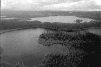
Photo. C1596-0l
Various areas immediately underlain by Ice-Contact Stratified Drift Deposits are evident in the central and lower parts of the photograph. An esker ridge forms part of the far shoreline of the small lake in the central and lower parts of the photograph. Argyle Lake is situated immediately beyond the esker ridge (central and central right parts of the photograph). The view is approximately east into the central part of the southeastern portion of the conservation reserve.
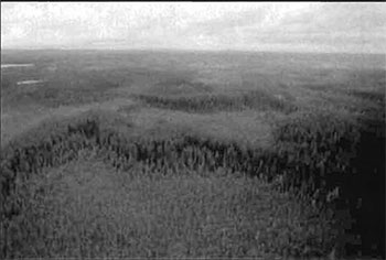
Photo. C1596-02
Numerous, well-developed, sand dunes are present in the area to the east of Argyle Lake. From a landscape perspective, the juxtaposition of dune forms and peatland is visually impressive. The view is approximately northwest across the central east and central parts of the southeastern portion of the conservation reserve.
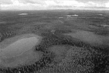
Photo. C1596-03
Provides a general view approximately south into the north half of the northwestern portion of the conservation reserve. A complex of eolian and organic landforms is evident in the central and lower parts of the photograph. Some of the numerous, well-developed, sand dunes, located in the northwest part of the northwestern portion of the conservation reserve, are apparent in the central right part of the photograph.
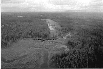
Photo. C1596-04
A well-developed, alluvial plain, immediately underlain by Alluvial Deposits (Unit 8), is associated with the Whitefish River in the central portion of the conservation reserve. The view is approximately NNE.
Appendix 10: James Bay Treaty
The James Bay Treaty - Treaty No. 9
Appendix 11: Robinson Treaty
Cat. No. Robinson Treaty. Ci 72-1264
Footnotes
- footnote[1] Back to paragraph Conifer stands are defined as follows: pure conifer stands contain 100% of a conifer trees in the canopy; dominant conifer stands contain less than 10% cover of hardwoods in the main canopy and predominant conifer stands contain less than 20% cover of hardwoods in the main canopy. Similarly hardwood stands may contain no conifer in canopy (pure hardwood), less than 10% conifer (dominant hardwood) or less than 20% conifer cover (predominant hardwood) (modified after Taylor et al 2000).
- footnote[2] Back to paragraph Wetlands were classified after Arnup et al. 1999 and Harris et al. 1996.
- footnote[3] Back to paragraph Diversity rating, developed by John Thompson & Jake Noordhof (2003), is based on the size of the conservation reserve versus the number of landforms:vegetation (SFU/HU) combinations. For CR’s <500 ha, high diversity is >25 L:V combinations, medium for >15 L:V, and low for <15 L:V. For areas 500-2000 ha, high is >30, medium >20 and low <20. For areas >2000 ha, high >35, medium >25 and low <25 L:V combinations.
- footnote[4] Back to paragraph Evenness of the site defined as strongly skewed (top 3 communities capture >=60% of the site in area), moderately skewed (30-59%) or slightly skewed to even (<30%).
- footnote[5] Back to paragraph Rating based on the amount of area currently under some form of known disturbance. High is >20% of the area, medium 10 to 20%, low <10% and pristine <1%.
- footnote[3.] Back to paragraph Rating based on the amount of area currently under some form of known disturbance. High is >20% of the area, medium 10 to 20%, low <10% and pristine <1%.
- footnote[4.] Back to paragraph Diversity rating, developed by John Thompson & Jake Noordhof (2003), is based on the size of the conservation reserve versus the number of landform:vegetation (SFU/HU) combinations. For CR’s <500 ha, high diversity is >25 L:V combinations, medium for >15 L:V, and low for <15 L:V. For areas 500- 2000 ha, high is >30, medium >20 and low <20. For areas >2000 ha, high >35, medium >25 and low <25 L:V combinations.
- footnote[5.] Back to paragraph Evenness of the site defined as strongly skewed (top 3 communities capture >=60% of the site in area), moderately skewed (30-59%) or slightly skewed to even (<30%).
- footnote[8] Back to paragraph Coordination could include a variety of expertise from the following: Field Services Division, Ontario Parks, Aviation and Forest Fire Management Branch, Forest Health and Silvicultural and Forest Management Planning Sections, Northeast Science and Information etc. Additional expertise within and outside the MNR could be sought as required.