Windermere Goldie Lake Complex Conservation Reserve Management Statement
This document provides policy direction for the protection, development and management of the Windermere Goldie Lake Complex Conservation Reserve and its resources.
January, 2005
Approval statement
I am pleased to approve this Statement of Conservation Interest (SCI) for the Windermere Goldie Lake Complex Conservation Reserve (C1535).
Direction for establishing, planning and managing conservation reserves is defined under the Public Lands Act and the Crown Land Use Policy Atlas. “Ontario’s network of natural heritage areas has been established to protect and conserve areas representative of the diversity of the natural regions of the province, including species, habitats, features and ecological systems which comprise that natural diversity.” (Policy 3.03.05, OMNR 1997).
This basic SCI will provide guidance for the management of the conservation reserve and the basis for the ongoing monitoring of activities. More detailed direction at this time is not anticipated. Should significant facility development be considered or complex issues arise requiring additional studies, more defined management direction, such as a conservation reserve Resource Management Plan (RMP), may be developed.
This SCI was reviewed by staff specialists at both the district and regional level of the Ministry of Natural Resources. The public was consulted prior to the regulation of the Windermere Goldie Lake Complex Conservation Reserve regulation and prior to the approval of this SCI. Comments and concerns which were received are reflected in this Statement of Conservation Interest.
The Windermere Goldie Lake Complex Conservation Reserve will be managed under the jurisdiction of the Area West Supervisor of the Ministry of Natural Resources, Chapleau District.
Submitted by:
Toni Armonas
Plan Author
Date: February 17, 2005
Recommended for Approval by:
Bob Johnston
District Manager
Date: February 22, 2005
Approved by:
Rob Galloway
Regional Director, Northeast Region
Date: April 05, 2005
1.0 Introduction
The Province of Ontario is home to a broad range of climate types, geography, and plant and animal species, all of which contribute to the variety and abundance of natural resources found here. The Ontario Ministry of Natural Resources (OMNR) is the lead conservation and resource management agency in the province and is therefore responsible for the management of these resources, in particular, forests, fisheries, wildlife, mineral aggregates and petroleum resources, Crown lands and waters, and provincial parks and protected areas (OMNR Beyond 2000).
The Ministry of Natural Resources is committed to the protection of natural and cultural heritage values and, as such, has developed strategies that will maintain the integrity and sustainability of the parks and protected areas system.
Recently, the Government of Ontario conducted a major land use planning exercise which resulted in the release of the Ontario’s Living Legacy Land Use Strategy (1999). The Land Use Strategy focuses on four specific objectives that were established to guide the planning process. These are:
- to complete Ontario’s system of parks and protected areas;
- to recognize the land use needs of the resource-based tourism industry;
- to provide forestry, mining, and other resource industries with greater land and resource use certainty; and
- to enhance hunting, angling and other Crown land recreation opportunities.
Ontario’s network of natural heritage areas has been established to protect and conserve areas that represent the diversity of the natural regions of the province including the species, habitats, special features and ecological systems which comprise that natural diversity. Protecting these natural heritage areas is essential to the sustainable management of natural resources. It ensures that representative sites are retained in their natural state and can continue to contribute to Ontario’s natural environment.
In order to preserve these sensitive areas, they require protection from incompatible uses. The creation of conservation reserves has been identified as a way of providing necessary protection from incompatible uses while still permitting many of the traditional uses that allow the people of Ontario to enjoy our special heritage.
Conservation reserves complement provincial parks in protecting representative natural areas and special landscapes. Most recreational activities (e.g. hiking, skiing, tourism related uses and nature appreciation) that have traditionally been enjoyed in the area will continue, provided that these uses do not impact the natural features needing protection. The management and administration of a conservation reserve is guided by an approved Statement of Conservation Interest (SCI) or a resource management plan (RMP) if the conservation reserve has many complex issues.
An approved Statement of Conservation Interest is the minimum level of management direction established for a conservation reserve The Statement of Conservation Interest defines the area that is being planned and the purpose for which the conservation reserve has been established. In addition, it provides management direction that will protect its natural and cultural heritage values and demonstrate its compatibility within the larger landscape. In addition, to ensure OMNR protection objectives are being fully met within the conservation reserve, the surrounding landscape and related activities must consider the site’s objectives and heritage values. Finally, it is the intent of this SCI to create a public awareness that will promote responsible stewardship of the protected area and surrounding lands.
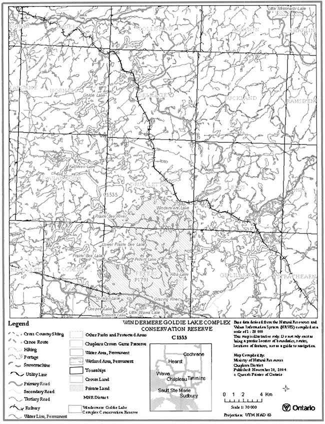
The Windermere Goldie Lake Complex Conservation Reserve is composed entirely of Crown lands and waters. This 18,699 hectare conservation reserve is in the final stages of the regulation process and is located southwest of the Town of Chapleau within the Territorial District of Sudbury, in Northeastern Ontario. The guidelines for the management of this conservation reserve are found in this document.
2.0 Goal and objectives
2.1 Goal of the SCI
The goal of a conservation reserve as stated in Conservation Reserve Policy PL 3.03.05 (OMNR, 1997) is to protect natural and cultural heritage values on public lands while permitting compatible land use activities. It is the intent of this Statement of Conservation Interest to provide the framework and direction to guide management decisions to ensure that the Windermere Goldie Lake Complex Conservation Reserve will meet this goal through both short and long term objectives.
2.2 Objectives of the SCI
2.2.1 Short term objectives
In order to ensure that the goal of this conservation reserve is met, the following short-term objectives have been identified:
- Identify the state of the resource with respect to natural heritage values and current land use activities for the conservation reserve; and
- Manage the conservation reserve to protect the integrity of its natural values via specific guidelines, strategies and prescriptions detailed in this plan
This Statement of Conservation Interest meets the planning requirement for conservation reserves as determined in Conservation Reserve Procedure PL 3.03.05, which states that management plans must be written within three years of the regulation date. (OMNR, 1997)
2.2.2 Long term objectives
In addition to the short term objectives mentioned above, long term objectives will assist in ensuring that the goal of this conservation reserve is met. The long term objectives for this SCI are:
- To establish representative targets and validate the site as a potential scientific benchmark;
- To identify research/client services and marketing strategies; and
- To provide direction to evaluate future uses or economic ventures.
3.0 Management planning
3.1 Planning context
3.1.1 Planning area
The planning area will consist of the regulated boundary for the Windermere Goldie Lake Complex Conservation Reserve as defined in section 4.1.3 Admmistrative Description and illustrated in map 8.1. This landbase will form the area directly influenced by this Statement of Conservation Interest. This plan will recognize the protection of values within the planning area, however, to fully protect values within the conservation reserve, additional consideration within larger land use or resource management plans may be required. Any strategies noted within this plan related to the site’s boundary or beyond will need to be presented for consideration within a larger planning context. The Ministry of Natural Resources in conjunction with other partners will work to ensure that the values are protected during planning and implementation of activities on the surrounding landbase.
3.1.2 Management planning context
The need to complete the parks and protected areas system has long been recognized as an important component of ecological sustainability. This was reaffirmed in 1991 when the Lands for Life planning process was announced. Previous gap analysis studies were used to determine proposed candidate areas that would protect additional representative features and other significant values. The Windermere-Goldie Lake Complex Conservation Reserve was chosen as one of the candidate areas to protect the areas natural heritage features, recreational values, and remote character and subsequently appeared in the Ontario’s Living Legacy Land Use Strategy as C1535. Following consultations with the public, local aboriginal communities and affected industries during the summer of 2003, the boundary was finalized and approved by the Ministry of Natural Resources.
Conservation reserves cannot be used for mining, commercial forest harvest, hydroelectric power development, the extraction of aggregates and peat, or other industrial purposes. Most recreational and non-industrial resource uses that have traditionally been enjoyed will be permitted to continue provided that they pose no threat to the natural ecosystems and identified values of the conservation reserve.
Permitted uses in conservation reserves will generally follow the direction expressed in the Land Use Strategy as well as any prior commitments that have been made by the Ministry of Natural Resources, Chapleau District office. For specific permitted uses pertaining to this conservation reserve, please see Appendix 9.2. Future uses or developments that are proposed for this conservation reserve will be subjected to the ‘Class Environmental Assessment (EA) for Provincial Parks and Conservation Reserves (PPCR)’, - http://www.ontarioparks.com/english/plan_ea.html [Inactive link]. Considerations for proposals pertaining to cultural resources may be screened through direction provided in the Draft ‘Interim Cultural Heritage Guidelines for the RSFD Class EA and the PPCR Class EA’ (OMNR July 19, 2004).
3.2 Planning process
Management of the conservation reserve includes, as a minimum, the regulation, provision of public information, stewardship, and security of the site. It also includes the authorization of permitted uses and ongoing monitoring of compliance with the approved SCI. Management of conservation reserves is the responsibility of the Ministry of Natural Resources at the district level, and will be done in accordance with Conservation Reserve Policy PL 3.03.05 and an approved SCI.
Once a conservation reserve has been established, a planning exercise is undertaken to determine the future management of the site. The appropriate plan must be completed within three years of the regulation date.
There are two policy documents that may be prepared: a Statement of Conservation Interest or a Resource Management Plan.
A Statement of Conservation Interest is the minimum level of planning required for a conservation reserve and may take the form of either a Basic Stewardship SCI or an Enhanced SCI. A Basic Stewardship SCI is used for sites where no decisions beyond the Land Use Strategy are required. An Enhanced SCI is used for sites that have one or more issues that need to be addressed.
The highest level of planning for a conservation reserve is a Resource Management Plan and would be written if the conservation reserve was deemed to have numerous complex issues.
Based on the criteria, which can be found in Planning Process for Conservation Reserves: Statements of Conservation Interest and Resource Management Plans; Northeastern Region Guidelines (Shilf and Thompson, 2001), a Basic Stewardship Statement of Conservation Interest was determined to be the appropriate form of management plan for this conservation reserve. No significant issues have been identified in the Windermere Goldie Lake Complex Conservation Reserve that would require decisions to be made beyond what has been previously determined in the Land Use Strategy.
As of February 2005, the Windermere-Goldie Lake Complex Conservation Reserve was in the final stages of regulation, local First Nation communities and the public were notified that the management planning for the conservation reserve was underway. This notification occurred via mail-out to the First Nation communities and stakeholders and an advertisement appeared in two local newspapers during the weeks of January 2nd and January 9th 2005. The Ministry of Natural Resources is exempt from providing notification of this planning process on the Environmental Bill of Rights Electronic Registry, under Section 30 of the Environmental Bill of Rights.
A draft version of this Statement of Conservation Interest has been reviewed by staff from the Ministry of Natural Resources as well as by members of the public and local First Nation communities. Comments provided from January 4th to February 3rd to the ministry during this review have been considered in the preparation of this draft document. Upon approval of this Statement of Conservation Interest, public notification will occur via mail-out to interested stakeholders and a notice will appear in the local newspapers.
This SCI is a working document and therefore may require revisions from time to time. For further information on reviews and revisions please see section 6.5 Implementation and Plan Review Strategies.
4.0 Background information
4.1 Location and site description
4.1.1 Location
The Windermere Goldie Lake Complex Conservation Reserve totals approximately 18,699 hectares (ha) in size and is located approximately30 kilometers northwest of the town of Chapleau, within the Chapleau OMNR District in the Northeast Region.
Table 1 provides administrative details of the site:
Table 1: Location and Administrative Details for Windermere Goldie Lake Complex Conservation Reserve
Table 1 reformatted into a list
- Name: Windermere Goldie Lake Complex Conservation Reserve
- Site - Site District (Hills): 3E-5
- Eco Region - Eco District (Crins and Uhlig, 2000): 3E-5 - Foleyet Ecodistrict District
- OMNR Administrative
Region/District/Area: Northeast/Chapleau/Area West - Total Area: 18,699 ha
- Regulation Date: To be announced
- First Nations: Robinson-Superior Treaty (the local First Nation community affiliated with this treaty in the District of Chapleau is Michipicoten First Nation)
- OBM map sheets: 41 O/13 and 42 B-4
- UTM Reference: 291526
- Municipality: None
- Township: Bliss, Collishaw, Cosens, D’Avaugour, Delmage, DruiIIettes, Gilliland, Hornell and Peters.
- Status: 100% Crown lands
- Watershed: 2BD
- Wildlife Management Unit: WMU 32
- Forest Unit: Superior Forest and Wawa Forest
- Nearest Town: Chapleau
4.1.2 Physical description
There are three main geographic areas of this site: Prairie Bee, which includes all areas south of the Prairie Bee Dam; Nicholson, which incorporates the southeastern section of Windermere Lake up to the town of Nicholson; and the Lakes Complex, which incorporates the rest of Windermere Lake and Goldie Lake.
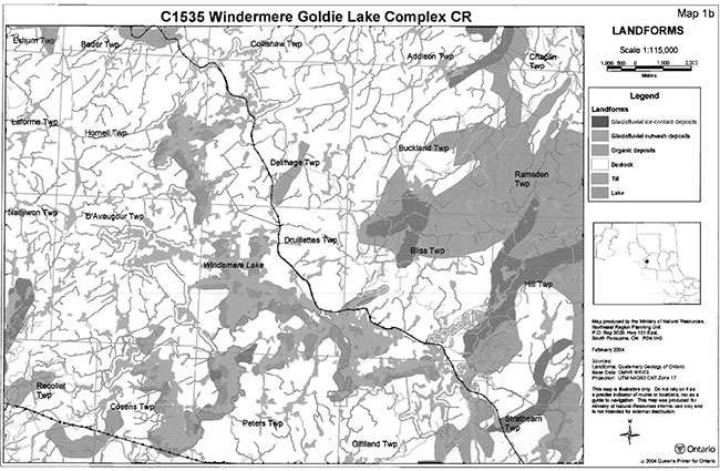
The topography of this site is generally rolling with flats along the many rivers and lakes. The area is dominated by bedrock-drift complex with till comprising the drift material. Eskers and kame complexes are found in the southern half of the site in the Lakes Complex area, which incorporates pockets of sand and gravel glaciofluvial outwash plain. Significant ice-contact stratified drift deposits also occur in the Lakes Complex areas and extends around Kathleen Lake, Healey Bay and the Prairie Bee area. These ice-contact stratified drift deposits sometimes occur in association with glaciolacustrine deposits. Small areas of organic deposits, sometime as a veneer, occur over much of the conservation reserve (Burkhardt, 2004).
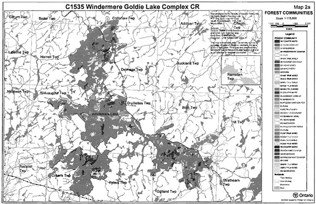
The forest communities located within this conservation reserve are typical boreal species with occurrences of certain species form the Great Lakes-St. Lawrence forest such as red maple. Although there are 44 different forest communities, the dominant forests are predominately balsam fir mixed wood and black spruce mixed wood which occur throughout the site. Poplar mixed wood forest are also well represented, occurring predominately north of Windermere Lake.
Stand age varies greatly for this conservation reserve ranging from 10 years for pure stands to 130 for a variety of the black spruce dominated stands. Old growth is well represented throughout the site. In the Prairie Bee section, stands generally range from 90-119 year in age while the Lakes Complex area is split between the 60-89 and 90-119 age groups (Burkhardt, 2004).
The conservation reserve is located in the eastern portion of the 2BD tertiary watershed of the Lake Superior major basin. Water makes up a large portion of this site and includes the following lakes: Goldie, Prairie Bee and Lower Prairie Bee, Windermere and Kathleen.
Wetlands are not a dominate feature in this conservation reserve and only account for 4.3% of the total area. In the Lakes Complex, wetlands consist of open water marshes, meadow marsh, shore fens, poor fen, moderately rich fen, semi-treed bogs and floating mats of red-green sphagnum moss and low shrubs. In Nicholson, the wetlands included open water marsh, meadow marsh, shore fen, poor fen, treed fen and treed bogs. In the Prairie Bee area, the wetlands include meadow marshes along the edges (possibly influenced by dam structures), float mats, semi-treed bogs, treed bogs and shore fens (Burkhardt, 2004).
4.2 Administrative description
The Windermere Goldie Lake Complex Conservation Reserve is currently in the final stages of the regulation process and once complete, will be formally protected under the Public Lands Act.
A copy of the site regulation description from the Ontario Gazette will be inserted in this document when it is published.
The Windermere Goldie Lake Complex Conservation Reserve is located primarily within the Superior Forest, with small portions extending into the Wawa Forest.
4.3 History of the site
First Nations of the region may have utilized the lands of this area in the past. A registered archeological check has been completed and no evidence has been documented within the conservation reserve (Von Bitter, R. 2004). However, there are pictographs within the adjacent Shoals Provincial Park, which indicates that early First Nation communities may have frequented the area (Mutter, T. 2004).
The earliest Europeans are known to have come to the area with the Hudson Bay Company, to establish a fur trading post on Big Missinaibi Lake in 1777, about 50 km north of the conservation reserve.
In the years to follow, the importance of fur trading began to decline while logging emerged as a primary industry.
(http://www.canadianfishing.com/chapleau/history.html) [Link no longer active]
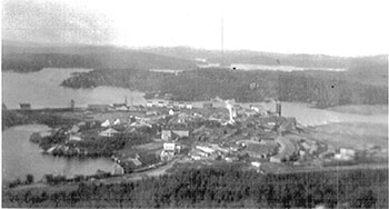
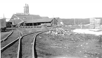
The area surrounding the conservation reserve is rich in logging history. In 1901 James McNeice Austin joined into a partnership with George B. Nicholson to form the Austin and Nicholson Lumber Company. The first operation was at Nicholson around 1910 on Windermere Lake, where they made railway ties for the Canadian Pacific Railway (CPR). At that time, the company operated four other sawmills in the area: Sultan, Dalton, Bertrands Siding and Devon. Up to 1929 it was recorded that 2.5 million ties were produced each year by the Austin and Nicholson Lumber Company, making it the largest producer of railway ties in the British Commonwealth (Mutter, 2004). The mill at Nicholson operated until 1931 when it burnt and was not re-built. Remnants of past logging activity can be found throughout the site. For example, there are still remains of an old piece of logging equipment, referred to as an ‘alligator,’ which is located on the shores of Kathleen Lake.
(http://www.canadianfishing.com/chapleau/history.html) [Link no longer active]
This area also has a long history associated with the railroad. In 1885 the Canadian Pacific Railway (CPR) was built through the Chapleau area. The CPR tracks form the majority of the eastern boundary of this site, and much development and human influence on the landscape in this area has resulted from the days of railroad construction. In fact, the settlement of Healey, located on the south-eastern boundary of the conservation reserve was established to accommodate CPR railway service crews.
Since that time, the area has been used extensively for recreational opportunities, particularly due to the large variety of waterbodies. Originally, the area was designated as “Area 11- Remote Recreation Area”, which was established under the 1983 Chapleau District Land-Use Guidelines (DLUG). The DLUG designated the area primarily for public outdoor recreation and prescribed that resource management plans would contain guidelines for the protection of significant recreation resources, historical and archaeological sites, and fish and wildlife habitats (OMNR 1983).
4.4 Inventories
The following table indicates what survey work has been done and what is required:
Table 2: Inventory and survey information
| Survey Level | Earth Science | Life Science | Cultural | Recreational |
|---|---|---|---|---|
| Reconnaissance Survey (RS) | Completed Sept. 25th, 2003 Preliminary | Completed Sept. 25th, 2003 | Completed Sept. 1st, 2004, no registered archeological sites found | Completed Sept. 25th, 2003 |
| Detailed | None completed at this time | Draft Life Science Report Completed July 2004 | None planned at this time | Recreation Report completed August 2004 |
| Requirement | Earth science interpretations should be digitized to assist with future landform vegetation analysis as time and funding permits. | Digitized life science information, SFU data, photos and sampling areas should be used to complete the current landform vegetation analysis as time and funding permits. | N/A | Ground assessment of trails, roads and should be conducted as time and funding permits to further assess current uses, access locations, and potential impacts to the site. Additionally, visits should be conducted in the winter to confirm seasonal use. |
5.0 State of the resource
The natural heritage of Ontario contributes to the economic, social and environmental well being of the province and its people. Protecting areas of natural heritage is important for many reasons, such as maintaining ecosystem health and providing habitat for species in order to maintain diversity and genetic variability. Protected areas also provide scientific and educational benefits, recreational and tourism opportunities, which bolster local and regional economies, and they provide places where people can enjoy Ontario’s natural diversity while enhancing their own health and well-being. In order to protect this vital natural heritage, a protected areas system which represents the entire range of the province’s natural features and ecosystems is needed (Natures Best, 1997).
Representation:
Completing the system of parks and protected areas is based on the concept of representation - capturing the full range of natural and cultural values by protecting areas that contain the best examples of our history, natural features, species and ecosystems. The complete system must therefore protect a range of natural heritage values based on the geological, biological and cultural diversity of the province. The best examples of representative features are often considered to be provincially significant and may even be nationally or internationally significant. In addition, locally and regionally significant areas also contribute natural heritage values to the protected areas system and have therefore been identified in some areas to meet the representation targets in each of the ‘Ecodistricts’.
The primary value of this site is the older mixed forest with poplar and jack pine on exposed bedrock. The vast majority of the site is represented by strongly broken deep and shallow sandy till (bare bedrock) with moderately aged white birch and black spruce stands. Moderate old growth jackpine also occurs on this landform. White pine, balsam fir and white cedar complete the vegetative stands on this landform type. An additional feature of this site is the diversity of the large lakes with many bays, edges, depths and shoreline material.
Quality of present representation:
The quality of the representation or the current characteristics of the natural features found within the conservation reserve are as important as the overall representative features that are being protected. A number of factors are considered in evaluating a site and they include the following criteria: diversity, condition, ecological factors, special features and current land use activities.
a) Diversity
Diversity is a measure of the site’s life and earth science variety. Diversity is evaluated in terms of the number and range (i.e. amount of richness and evenness) of vegetative communities currently present within the conservation reserve. Natural landscapes and known generalized vegetative communities will be the scale used for this SCI. Future aerial or ground reconnaissance surveys will enhance the OMNR’s knowledge of these features and possibly allow verification at a lower scale (e.g. species assemblages). Diversity is rated as high if the site contains more than 35 landform vegetation combinations, medium if is contains between 25 and 35 and low if it contains less than 25 landform vegetation combinations (Burkhardt, B. 2004).
As mentioned above, richness is a key component of diversity. This conservation reserve is rich in vegetative cover types. Forest communities are represented by almost every typical boreal species including black spruce, white birch and poplar and are represented at every developmental stage. The richness of the Windermere Goldie Lake Complex Conservation Reserve is somewhat increased by the presence of different wetlands including float mats, meadow marsh, shore fens, bogs and fens however their limited presence (4.3%) add little to the total diversity of the site.
The evenness of this site is moderately skewed with the top three standard forest communities within the site (mixed wood, spruce pine, spruce fir) capturing 34.5% of the site. These communities are well represented across the entire conservation reserve and not restricted to a particular area.
Despite being rich in vegetation cover types and having a moderately skewed evenness, the fact that the conservation reserve is dominated by bedrock-drift complex, causes the number of different landform vegetation combinations to be low. As such, the overail diversity of this conservation reserve has been ranked as low (Burkhardt, 2004).
b) Ecological factors
Ecological factors refer to the current design of the conservation reserve as noted by its size, shape, and buffering capacity to adjacent land use activities. Generally, larger sites with more diversity are better than small, non-diverse areas; sites with a more rounded or naturally delineated shape are better than long, linear sites; and sites that are linked to or near other protected areas are better than isolated protected areas. In addition, the site’s linkage to undisturbed landscapes also contributes to the conservation reserve’s ecological integrity.
In general, site boundaries have been formed using both natural and man-made features. Around many water bodies the boundary had been set back from the water’s edge a certain distance. In other areas the boundary had been created by following man-made features such as the CPR rail line. Some straight line vectors have also been used to complete the boundary delineation where appropriate. These vector boundaries sometimes sever forest communities and wetlands (Burkhardt, B. 2004).
The Windermere Goldie Lake Complex Conservation Reserve is situated directly adjacent to the Shoals Provincial Park. Collectively, these two protected areas compliment each other in the protection of natural and cultural heritage values by prohibiting major commercial and industrial activities that have the potential to negatively impact these values. This “connection” enhances the ecological integrity of both the provincial park and the conservation reserve by effectively creating one large area of the landscape that is free from major resource developments. The Windermere Goldie Lake Complex Conservation Reserve is adjacent to and partially overlaps the Crapleau Crown Game Preserve. While the Game Preserve does not provide a similar level of protection as conservation reserves and provincial parks, it does prohibit hunting and commercial fur harvest.
c) Condition
Condition is the degree of past human and natural disturbances observed or recorded for the site, Major natural disturbances in the Northeast Region are caused by fire, wind damage, floods, or insect and disease infestation. Human disturbances are wide ranging and could include forestry, mining, railways, roads, trails, dams, cottages or other development. Condition is rated as high if the area is more than 20% disturbed, medium if 10-20%, low less than 1%, and pristine is less than 1% (Burkhardt, B. 2004).
Disturbances on the site are both natural and human induced. Other natural disturbances to the site have included white birch and poplar decline (natural succession) in areas around Nicholson and southwest edge of the Prairie Bee section. In addition, in the Nicholson area, just off the Windermere River, flooding has occurred due to beaver activity in the area.
Human disturbances vary throughout the conservation reserve. Much of the conservation reserve was horse logged by the Austin and Nicholson Lumber Company in the early 1900’s. Harvesting has occurred around the edge of the site in several locations, most notably west of Prairie Bee Lake and east of Nicholson. A remnant of a bridge still remains at a harvest block access near the Windermere River. Dams also exist on Kathleen Lake and Windermere Lake, and on the mouth of Prairie Bee River, north of Lower Prairie Bee Lake. These dams are in working condition and continue to be used by Great Lakes Power (Brascan), to support power production on the Michipicoten River.
Numerous commercial outpost camps, as well as private recreation camps and camping areas also exist within this conservation reserve.
Considering the size of this site, disturbance for this conservation reserve is rated low to medium. Most of the disturbances have occurred in isolated patches, with nothing occurring in a widespread pattern.
d) Special features
Special features are those features that, in addition to the primary value of the site, add to the distinctiveness of a site. Examples of these features include interesting landscapes, habitats or vistas, Species at Risk (SAR) and other earth and life science features, including broader landscape elements that contribute to the natural heritage richness of Ontario.
The main special feature, as previously mentioned, is older mixed forest with poplar and jack pine on exposed bedrock. In addition to this, the presence of supercanopy white pine and maples (species of the Great Lake St. Lawrence Forest Region) located at the north end of the conservation reserve add to the distinctiveness of the site. The diversity of large lakes with their many bays, edges, depths and shoreline material also add to the value of the site.
e) Current land use activities
As previously mentioned, the quality of the representation or the current characteristics of the natural features found within the conservation reserve are as important as the overall representative features that are being protected. Land use activities can have a substantial impact on the quality of representation.
Within the Windermere Goldie Lake Complex conservation reserve there are commercial tourism establishments, private recreation camps, and some private land parcels. Goldie Lake is identified as a designated tourism lake under the Crown Land Use Policy Atlas, which indicates that remote tourism activities are a primary land use on this lake. Other commercial land use activities include trapping, baitfish harvesting and commercial bear management. This conservation reserve is also used by many different recreationalists. Many activities, such as hiking, camping, fishing, etc, are known to occur within the site. For more information please refer to ‘Recreation Inventory Report for Windermere Goldie Lake Complex Conservation Reserve’ (Mutter, T. 2004).
5.1 Social interest in area
5.1.1 Linkage to local community
This site provides the communities of Chapleau and Wawa, as well as many other smaller communities in the area; a protected area to enjoy outdoor activities which may include camping, hunting, fishing, nature appreciation, hiking, snow shoeing, snowmobiling, canoeing and ATV use. The area may also be used by people who have interest in visiting the adjacent Shoals Provincial Park. In addition to this, economic benefits to the region stem from trapping, hunting, angling, and other tourism and recreational oppotunities in the area.
Windermere Goldie Lake Complex Conservation Reserve is accessible by numerous secondary and tertiary roads off of Hwy 101. The secondary and tertiary roads access the western and eastern portions of the conservation reserve. The entire eastern portion of the site can be accessed by the CPR rail line. The local passenger car, known as the “Bud” Car, travels along the eastern edge on a daily basis with the exception of Monday, traveling West on Tuesday, Thursday and Saturdays, and traveling East on Wednesdays, Fridays and Sundays (Via Rail Customer Service Centre 2005).
5.1.2 Aboriginal interests
The conservation reserve falls in the area of the Robinson-Superior Treaty. The local First Nation community affiliated with this treaty in the District of Chapleau is the Michipicoten First Nation. There is no known registered archaeological evidence found within the site (Von Bitter, R. 2004). The designation of this area as conservation reserve and the subsequent planning, including this SCI, does not affect the treaty or aboriginal rights.
5.1.3 Other government agencies, departments or crown corporations
Other agencies or departments that may have an interest in this conservation reserve include the Ministry of Tourism and Recreation, the Ministry of Culture, the Department of Fisheries and Oceans Canada, the Ministry of the Environment, the Ministry of Northern Development and Mines, and the Ministry of Municipal Affairs and Housing. At this time, no other government agency has shown a specific interest with respect to this particular protected area.
5.1.4 Non government organizations and other industry interest
Industrial sectors that may have an interest in the Windermere Goldie Lake Complex Conservation Reserve could include the forestry industry, the mining industry and the tourism industry. Non-government organizations that may have an interest in the site, could include the Partnership for Public Lands, the Federation of Ontario Naturalists, Northwatch, the Chapleau Regional Development Corporation, the Baitfish Association of Ontario, the Northern Ontario Tourist Outfitters as well as local snowmobile clubs, trapper councils, and hunting and angling organizations.
5.2 Natural heritage stewardship
The Windermere Goldie Lake Complex Conservation Reserve contributes to Ontario’s parks and protected areas system. Through formal protection under the Public Lands Act and long-term management direction, the site’s natural heritage values and representative features, and remote recreational features will be protected and/or enhanced.
By allocating these lands to the parks and protected areas system, the Province has ensured a certain level of permanence by distinguishing the site and its values from the surrounding landscape. Each protected area contributes to Ontario’s natural and cultural heritage in its own unique way - whether it is a contribution to the preservation of an earth science value, a life science value, a recreational or economic opportunity or through protection afforded to cultural and historical values. The site’s earth and life science features, as described in section 4.1.2, make a number of contributions to the provinces natural heritage values (Burkhardt, B. 2004 & OMNR, 1999).
This site is also available for scientists and educators who wish to study various aspects of the sites features, while continuing to provide various recreational opportunities for communities in the area.
5.3 Fisheries and wildlife
The wildlife found within the site is consistent with typical wildlife found in Ecodistrict 3E-5, including the various types of birds, ungulates and furbearers. The area provides good moose habitat, both terrestrial and aquatic. Early winter habitat typically consists of mature or over mature mixedwood stands of relatively low stocking. The dominance of mixedwood stands in this conservation reserve and the open canopy contributes to shrub productivity and browse available within the site. Very little late winter habitat exists (dense stands of mature conifer, eastern hemlock, cedar, balsam fir and white spruce preferred over black spruce and jack pine). District trapping files also confirm the presence of numerous furbearing animals including, black bear, beaver, muskrat, otter, marten, mink, fisher, raccoon, weasel, red squirrel, lynx, red fox, and timber wolf.
Windermere River is clear blue in colour and contains rapids, beaver dams, and spawning beds. It ranges up to 30 meters deep, and has a mean depth of 8.0 meters. Fish species in Windermere include walleye, northern pike, smallmouth bass, lake whitefish, lake trout, yellow perch, long nose sucker and stickleback. Much of the main portion of Windermere Lake contains deep pockets with low temperature and good oxygen levels that are requirements for lake trout. Goldie Lake is clear yellow/brown in color and overall fairly shallow with numerous small creeks flowing into the lake. Fish species present include lake white fish, northern pike, white sucker, burbot and yellow perch. Prairie Bee and Lower Prairie Bee Lakes are also clear, yellow brown in color though do not support as many fish species as Windermere Lake. Kathleen Lake is known to support a variety of fish including whitefish, white sucker, small mouth bass, walleye and yellow perch. For further information on fisheries within the conservation reserve, please see the ‘Recreation Inventory Report for Windermere Goldie Lake Complex Conservation Reserve’ (Mutter, T. 2004).
5.4 Cultural heritage stewardship
There are no known registered archaeological sites within Windermere Goldie Lake Complex Conservation Reserve (Von Bitter, R. 2004) and to date no detailed research has been conducted to document any possible archaeological remains. Though no archaeological remains have been found within the conservation reserve, evidence that First Nations have used this area in the past is evident by the presence of pictographs in the Shoals Provincial Park, which is directly adjacent to the site (Mutter, T. 2004).
If archaeological or cultural resources are discovered within the conservation reserve, management of these values will be consistent with ‘Conserving a Future for Our Past: Archaeology, Land Use Planning & Development In Ontario’ (Ministry of Citizenship, Culture and Recreation, 1997). If MNR receives proposals for activities that have the potential to disturb unidentified cultural heritage resources, the proposal will be screened against the draft ‘Interim Cultural Heritage Guidelines for the RSFD class EA and the PPCR class EA’ (OMNR. July 192004).
5.5 Existing development and land use
The Windermere Goldie Lake Complex Conservation Reserve consists of various forms of land use and tenure. There are several small parcels of private land located within the site, as well as two small settlements (Nicholson & Healey), which are located along the CPR rail line directly adjacent to the site. There are land use permits for access points, private recreational camps and commercial outposts.
There is a designated canoe route that travels through Prairie Bee, Lower Prairie Bee, and Windermere Lakes. This route, known as the “north loop”, is associated with the Shoals Provincial Park and is well known in the local area. The canoe route is ideal for beginner or novice canoeists. The route requires two days time, is approx. 40 km in length, and has 8 portages of varying difficulty. Portages are well marked out and there are several suitable camping sites found along the way (Mutter, Tim. 2004). The route begins at the public access point at the south end of Prairie Bee Lake, inside the Shoals Provincial Park boundary just off Hwy. 101. It continues down the east shore, through the ‘dividing narrows’, and into Lower Prairie Bee Lake. Then the route follows the Prairie Bee River to Windermere Lake, then east on Windermere Lake all the way to the settlement of Nicholson. At Nicholson, the canoe route continues south down through the Graziny Inlet to the Grazing River. The route then leaves the Grazing River and there is a portage into Little Wawa Lake. The route ends at the Shoals Provincial Park campground (Mutter, T. 2004). Camping sites associated with the canoe route are located in the conservation reserve. These sites are located along the shores of Prairie Bee Lake and Lower Prairie Bee Lake. Continued use of these camp sites within the conservation reserve is permitted and will continue to be promoted through the Shoals Provincial Park, provided no significant demonstrated conflicts arise.
There is a second unofficial canoe route located along the Goldie River at the north end of the site. This area is very remote and the only means to access Goldie River directly is by the railway tracks (CPR ‘bud’ car). This is not a very well known route and there are no established camp sites located along the route. There are several undeveloped portages and, therefore, traversing the route would be challenging to the experienced backcountry canoeist. This route starts where the CPR tracks cross the Goldie River. It then circles the Goldie River, first going north up through the river, then west under the CPR tracks, and then back down to Goldie Lake. To finish, the route would come back to the east across Goldie Lake and then through the Goldie River back to the CPR tracks. It is not known exactly how long the route is or how long it would take a canoeist to travel the route (Mutter, Tim. 2004).
In addition to canoeing, the site is also heavily used for recreational boating. There are three boat launches that access the site. There is a public boat launch (user pay) in Shoals Provincial Park off of Hwy 101. There is also a private boat launch associated with a Land Use Permit (LUP), on a southeastern portion or Prairie Bee Lake. This private boat launch is exclusive to Prairie Bee Camps and is not open to public use. There is also a private boat launch on Windermere Lake at the settlement of Healey. which has traditionally been available for public use for a small fee. Healy is accessible by road via the Esher-Healy Rd.
There is an existing License of Occupation (No. 7172) issued to Great Lakes Power Limited (Brascan). This allows for the operation of two dams that control flow rates and water levels on Windermere Lake (Lake level not to exceed an elevation of 1405 ft) and to regulate the water level of Kathleen Lake (not to exceed the elevation of 1403 ft). One of these dams, which is in a state of disrepair, is located on Kathleen Lake. It was originally built with wood and used in the early forest harvesting periods to raise water levels for log drives. As a result, a lot of log debris is found around the dam and along the shoreline in the area. The other dam is located between Kathleen Lake and Windermere Lake. There is a portage located on the north side of this dam (Lepage, R. 2004). There is also an OMNR self-operating weir located between Prairie Bee River and Windermere Lake (Montgomery, C. 2004). There are portages that traverse around both sides of this structure.
The CPR rail line forms a significant portion of the northeastern boundary of the site and provides access to a majority of the site by a rail car, known as the “Bud Car”, There is a primary forest access road located to the east of the site called the Austin Road. Although this road only borders the conservation reserve just north of Little Island Lake, it provides direct access to the site through various tertiary roads and trails that branch off into the site. The site can be accessed by a rough trail just south of Burnt Lake which was originally created in the 1980’s for forest harvesting activities. The CPR reconstructed this road and extended it to the CPR ‘right of way’ bordering the conservation reserve to access a train wreck that occurred in 2003 (Cooke, R. 2004). This access method is currently not recognized as authorized and the OMNR intends to discourage public use of this trail. Future site monitoring may result in additional steps being taken to control access to the site via this route.
The site can also be accessed indirectly by the CPR ‘right-of-way’ off another trail system further south of Burnt Lake. This access method is also currently not recognized as authorized and the OMNR intends to discourage public use of this trail. Furthermore, public travel along or within the CPR ‘right-of-way’ is prohibited unless authorized by CPR authorities. In addition, there is another trail network that accesses the site off of the Austin Road. This trail system branches to the west off the Austin Road and leads to Phone Line Bay (Montgomery, C. 2004). OMNR considers this traditional access and public use of these trails will be permitted to continue, unless there are significant demonstrated conflicts.
The Chapleau Arctic Watershed Snowmobile Club Inc. maintains a main Ontario Federation of Snowmobile Clubs (OFSC) snowmobile trail which runs adjacent to the site. Trail “F” just borders the conservation reserve at the eastern end of Little Island Lake, a bay off Windermere Lake (Mutter, T. 2004).
There is a secondary road (Esher-Healey Road) that leads to the southeastern portion of the site and provides road access to the settlement of Healy. There is an extensive network of former forest access roads that branch out from the Esher-Healy roacl which provide access to the southeastern portion of Windermere Lake in Gilliland Township. This trail network also traverses west just beyond the southeastern boundary of the conservation reserve and continues to a boat cache
Hwy 101 provides access to the conservation reserve through its access to the Shoals Provincial Park which is adjacent to the conservation reserve. There is an access road which leads from Hwy 101, through the park, to the boat launch on Prairie Bee Lake. As mentioned above, along with the public boat launch in the Shoals Provincial Park, there is a private boat launch which is associated with a LUP which provides water access to Prairie Bee Lake. There is also a network of trails associated with other resource users (trapping, BMA, and BHA) in the Townships of Cosens (between Hwy 101 and the western shores of Prairie Bee Lake) and O’Avougour (between Kathleen Lake and Prairie Bee Lake on the west side of the site) (Lepage, R. 2004). It is also likely that these trails are used by recreationalists and potentially provide access to the western portions of the conservation reserve. OMNR intends to monitor public use of these trails and if significant demonstrated conflicts become evident, appropriate management direction will be taken.
The remnants of a bridge still remain at an old harvest block north of Windermere River, as well as an abandoned pick-up truck in the same vicinity. Portions of several plantations, which are located just north of Coe Lake, are situated within the southeastern portion of the conservation reserve, directly adjacent to Shoals Provincial Park. These jack pinel black spruce plantations were planted in 1994 and were previously part of Tembec’s Sustainable Forest License (Cooke, R. 2004).
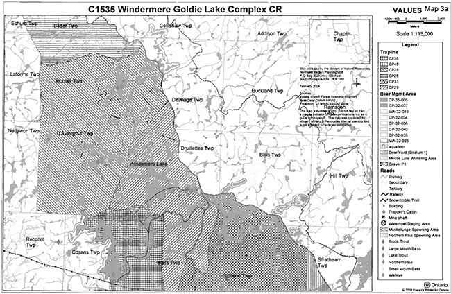
This conservation reserve falls within five trapline areas (CP 26, CP 28, CP 29, CP 36 and CP 37) with two trap cabins lying within the conservation reserve. In addition, portions of five Bear Management Areas (BMA) (CH 32-034, CH 32-035, CH 32-036, CH 32-040 and WA 32-023) and nine commercial Baitfish Harvest Areas (CH0043, CH0058, CH0059, CH0072, CH0073, CH0074, CH0086, CH0087, and CH0088) are also present within the site.
Three commercial outpost camps and one base lodge, authorized under a LUP occupational authority, are located within the conservation reserve. There is also a base lodge in Healy (Happy Day Lodge), just outside the boundary of the site. This facility is located on private land. Another commercial tourism operator (Four Seasons Guiding) also brings clients into the site via a trail system which runs from the base lodge on Big Pine Lake to the south shore of Windermere Lake.
Great Lakes Power Limited (Brascan) operates the dam facility between Kathleen and Windermere lakes to manipulate the water levels on Windermere Lake and as a result, control flows to the Michipicoten River which is used for hydro generation.
This conservation reserve has no mining tenure within it. Mining and surface rights have been withdrawn from staking within the conservation reserve boundaries under the Mining Act (RSO 1990 Chapter M.14).
5.7 Recreational use
The site is currently well used by recreationalists. Recreational uses include hunting, angling, camping, snowmobiling, canoeing, boating, swimming, snorkeling /scuba diving, bird watching and nature appreciation, among others.
There are two canoe routes associated with this conservation reserve. The first, called the “north loop,” traverses up and around the northern boundary of Shoals Provincial Park. This canoe route is locally well known and suited for the novice canoeist. As previously mentioned in section 5.5 there are camping areas identified along the shores of Prairie Bee Lake and Lower Prairie Bee Lake which are used by recreationalists who use this canoe route. For more information on the locations of these sites please see ‘The Shoals Provincial Park’ brochure (OMNR. 1995). The other route, known unofficially as the “Goldie River route,” traverses up and around the Goldie River, originating and ending at Goldie Lake. This route is relatively unknown, very remote, and has several extended portages. It is likely more suited for the experienced canoeist.
There are currently no proposals for new recreational uses or tourism facilities within this site. For further information on recreational activities within the conservation reserve, please see the ‘Recreation Inventory Report for Windermere Goldie Lake Complex Conservation Reserve’ (Mutter, T. 2004).
5.8 Client services
Visitor services will primarily involve responding to inquiries about basic information such as natural heritage representation and appreciation, permitted uses, access and boundaries. In addition to the provision of public information regarding the protected area, concerns with respect to public safety and area security will be addressed.
6.0 Management
6.1 Management planning strategies
Earth and life science features will be protected from adverse impacts by defining permitted uses, enforcing regulations (Ont. Reg. 805/94 PLA), monitoring site use and mitigating any identified concerns. The land use intent outlined in the 1999 Land Use Strategy provides context and direction to land use and resource management within this conservation reserve. Management direction identified in current policy (Conservation Reserve PL 3.03.05 and 1999 Ontario’s Living Legacy Land Use Strategy) forms the basis for the management planning strategies presented within this SCI. For additional information on permitted uses refer to Appendix 9.3. For general policy information on provincial conservation reserves, please refer to the Ministry of Natural Resources Crown Land Use Atlas.
New land use activities and development proposals will be reviewed on a case by case basis. A review under the ‘Class EA for PPCR’ must be completed before any uses or developments are approved. The emphasis will be on ensuring that the natural values of the conservation reserve are not negatively affected by current or future activities.
Permitted uses in conservation reserves will generally follow the direction expressed in the 1999 Land Use Strategy as well as any prior commitments that have been made by the Ministry of Natural Resources Chapleau District office.
The development of this SCI and the long term management and protection of the Windermere Goldie Lake Complex Conservation Reserve will be under the direction of the OMNR’s Chapleau District, Area West Supervisor.
6.2 State of the resource management strategies
The following sections outline some of the management strategies that have been developed to maintain and protect the identified values of the site. A detailed list of permitted uses within this conservation reserve can be found in Appendix 9.2 of this SCI.
6.2.1 Aboriginal interests
Traditional activities and Aboriginal rights, as defined by the Robinson-Superior Treaty, will not be affected within the boundaries of this conservation reserve. All Aboriginal and treaty rights will continue to be recognized and will not be impacted by the designation of the area as a provincial conservation reserve.
6.2.2 Natural heritage stewardship
The management intent of this conservation reserve will be to protect natural ecosystems, processes and features while continuing to allow compatible, low-impact land use activities.
The OMNR recognizes fire as an essential process fundamental to the ecological integrity of conservation reserves. In accordance with existing Conservation Reserve Policy and the current Forest Fire Management Strategy for Ontario, forest fire protection will be carried out as on surrounding lands. Whenever feasible, the OMNR fire program will endeavor to use “light on the land” techniques, which do not unduly disturb the landscape, in this conservation reserve.
Examples of light on the land techniques may include limiting the use of heavy equipment or limiting the number of trees felled during fire response efforts. Opportunities for prescribed burning to achieve ecological or resource management objectives may be considered. These management objectives will be developed with public consultation prior to any prescribed burning, and will be reflected in the document that provides management direction for this conservation reserve. Plans for any prescribed burning will be developed in accordance with the OMNR Prescribed Burn Planning Manual, and the Class Environmental Assessment for Provincial Parks and Conservation Reserves.
OMNR will provide leadership and direction for maintaining the in:tegrity of this site as a natural heritage estate. Research, protection, education, understanding and interpretation of the natural heritage features of the site will be encouraged and fostered through local and regional natural heritage programs and initiatives.
The introduction of exotic and/or invasive species will not be permitted. Programs may be developed to control forest insects and diseases in the conservation reserve where these threaten significant heritage, aesthetic, or economic values. Where control is desirable and possible, it will be directed as narrowly as possible to the specific insect or disease. Biological control will be used wherever possible.
In addition, the collection and/or removal of vegetation and palis thereof will not be permitted unless otherwise stated in the conservation reserve policy/permitted uses table. However, subject to the ‘Class EA for PPCR’, the West Area Supervisor may authorize the collection of plants and/or parts of plants for the purposes site rehabilitation if required and for research or scientific study.
Exceptions based on the ‘Class EA for PPCR’ may be made for minor structures for monitoring and research for scientific purposes (see section 6.4).
6.2.3 Fish and wildlife
Fish and wildlife resources will continue to be managed in accordance with applicable policies and regulations prevailing in the area and under the direction of the Area West Supervisor.
Existing sport hunting and sport fishing activities will be permitted to continue unless there are significant demonstrated conflicts.
6.2.4 Cultural heritage
No registered archaeological sites have been identified in the Windermere Goldie Lake Complex Conservation Reserve (Von Bitter, R. 2004). If archaeological or cultural resources are discovered within the conservation reserve, management of these values will be consistent with ‘Conserving a Future for Our Past: Archaeology, Land Use Planning & Development In Ontario’ (Ministry of Citizenship, Culture and Recreation, 1997). If MNR receives proposals for activities that have the potential to disturb unidentified cultural heritage resources, the proposal will be screened against the draft ‘Interim Cultural Heritage Guidelines for the RSFD class EA and the PPCR class EA’ (OMNR. July 19 2004).
6.2.5 Existing development and land use
The existing development, as described in section 5.5 is permitted to continue.
Authorized roads and trails currently existing can continue to be used. No new roads will be permitted within the conservation reserve, new trails may be considered subject to the ‘Class EA for PPCR’. For details on permitted uses within the conservation reserve, please see Appendix 9.2. Should a new trail be proposed, special consideration will be given to the values found within the site and how the proposed trail may impact those values. In general, new trails should avoid low-lying areas and wetlands.
The sale of lands within this conservation reserve is not permitted as per direction outlined in the Land Use Strategy. Road realignment, energy transmission, communication and transportation corridors, resource roads, or construction of facilities are discouraged. It is recognized that in some circumstances there may be no viable alternatives in which case options to minimize potential impacts to the values of the site will be determined through applicable planning processes.
New development proposals will be reviewed on a case by case basis, subject to all relevant conservation reserve policies and the ‘Class EA for PPCR’. Consideration will also be given to the effect that future development and/or additional access may have on the vaiues of the Shoals Provincial Park.
6.2.6 Commercial and industrial use
The current level of commercial use within this site, including hunting, trapping and baitfish harvesting will be permitted to continue.
Existing commercial bear management operations and traplines are permitted to continue. The issuance of new licenses for existing commercial bear hunting operations will be permitted where areas have been licensed or authorized for the activity at any time since january 1, 1992, provided that the activity does not create or aggravate resource sustainability issues. New licenses will not be permitted in areas where a license for commercial bear management has not been issued since January 1, 1992.
New commercial tourism operations, including applications for commercial tourism outpost camps, main base lodges or associated facilities, may be considered in the context of this management document and will be subject to the ‘Class EA for PPCR’.
Industrial activities such as timber harvesting, mining, and new hydro generation will not be permitted within the boundaries of the conservation reserve as per Policy 3.03.05. As mentioned above, the existing authorized access roads will be permitted to continue however no new resource access roads will be permitted.
6.2.7 Recreation / access
Recreation activities that have traditionally been enjoyed in this area are permitted to continue provided they do not significantly impact the values of the site. Current recreational activities include hunting, trapping, angling, camping, snowmobiling, canoeing, and boating, swimming, snorkeling /scuba diving, bird watching and nature appreciation, among others.
This area has long been recognized as providing quality recreation experiences in a relatively remote setting. This area was formerly recognized as a ‘Remote Recreation Area - Area 11’ under the Chapleau District Land Use Guidelines, and it is the OMNR’s intent to ensure these values are maintained through the active management of this protected area. Under the direction of the Area West supervisor, Chapleau district staff will ensure that all activities within the site are consistent with maintaining the remote recreational values that have been recognized.
Access to the conservation reserve by motorized vehicles (e.g. snowmobiles and ATVs) will continue to be permitted on existing authorized roads and trails providing it is compatible with the conservation reserve values and does not disturb sensitive wetland areas. The construction and or use of new roads will not be permitted. New recreational trails may be considered subject to the ‘Class EA for PPCR’. Use of motorized vehicles off trail is not permitted except for the sole purpose of retrieving game (OMNR September 2000).
Efforts will also be made to ensure that resource management plans on adjacent lands are designed such that the semi-remote character of this conservation reserve is maintained. Specifically, where resource management activities encroach near the boundary of the site and new access is planned, road use strategies will be developed to:
- Avoid improving access to the conservation reserve by placing roads/trails a reasonable distance back from the boundary of the site.
- Using winter roads where possible.
- Where it is absolutely necessary that roads be constructed in close proximity to the site, road abandonment & rehabilitation will be required when the intended use of the road has been met. Road rehabilitation will be conducted such that motorized vehicle passage along the road is inhibited.
- Implement timing restrictions for the protection of tourism and other recreational values where appropriate.
Currently, no research or interpretive facilities exist within the conservation reserve. Future recreational development or new recreation facilities may be considered subject to the ‘Class EA for PPCR’.
No new private recreation camps will be permitted in the conservation reserve.
6.2.8 Client services
Under the direction of the Area West Supervisor, Chapleau District, staff will respond to requests for information on the site pertaining to regulated boundaries, natural heritage values, current access and infrastructure, permitted uses or any other additional information that is required.
A general fact sheet regarding the values of this site will be prepared and made available to the public at the Chapleau District Office.
6.3 Specific feature/area/zone
In the future, if the representative features of the site are threatened by increased use, it may be necessary to regulate access or permitted uses in certain areas. In such a case, special management areas may be developed. These areas would facilitate permitted/restricted activities for the protection of specific values. The creation of these areas would require additional planning beyond this SCI including public consultation and eventual plan amendment if approved.
6.4 Promote monitoring and research
Scientific research by qualified individuals, which contributes to the knowledge of natural and cultural heritage and to environmental and recreational management, will be encouraged. Research related to the study of natural processes will also be encouraged provided it does not harm the identified values of the conservation reserve.
This site may be considered as a potential monitoring and/or research site. The natural state of Windermere Goldie Lake Complex Conservation Reserve especially in regards to the geological landforms, the many candidate old growth forests and the biological processes that occur in this landscape qualify the site as a possible ecological benchmark. The relatively easy access and the presence of undisturbed forest communities of the conservation reserve could provide both OMNR and associated partners potential sampling or monitoring areas. All research programs will require the approval of the Ministry of Natural Resources and will be subject to ministry policy and other legislation. Those interested in pursuing research within the conservation reserve must apply to the Area West Supervisor for approval. Applications to complete the research will follow guidelines as outlined in Procedural Guidelines C - Research Activities in Conservation Reserves (Conservation Reserve Procedure PL 3.03.05) or equivalent direction formulated by the OMNR Chapleau District Office. Approvals will meet all terms and conditions established by the OMNR Chapleau District Office.
The ministry may approve, on a case by case basis, the removal of any natural or cultural specimen by a qualified researcher. All such materials removed remain the property of the Ministry of Natural Resources.
Additional life and earth science requirements, as previously outlined in section 4.4, will refine the values of this site and assist with further development of management guidelines. As time and funding permits, the completion of more detailed life and earth science inventories will further help define the role of this conservation reserve within the system of provincially protected areas.
6.5 Implementation and plan review strategies
Implementation of this SCI will primarily involve monitoring activities to ensure adherence to the management guidelines. Other activities will include funding future life and earth science inventories, preparing a fact sheet highlighting the important natural heritage values of the conservation reserve and responding to inquiries about the site.
Implementation of the SCI and management of the conservation reserve are the responsibility of the Area West Supervisor. Partnerships may be pursued to address management needs. The Windermere Goldie Lake Complex Conservation Reserve SCI will be reviewed on an ongoing basis. If changes in management direction are needed at any time, the significance of the changes will be evaluated. Minor changes, which do not alter the overall protection objectives, may be considered and approved by the Area Supervisor without further public consultation and the plan will be amended accordingly. In assessing major changes, the need for a more detailed Resource Management Plan (RMP) will first be considered. Where a management plan is not considered necessary or feasible, a major amendment may be considered with public and First Nation consultation. Notification will additionally occur on the Environmental Bill of Rights Registry. The OMNR Regional Director will approve any major amendments.
This SCI or future RMP, if required, plus the Crown Land Use Atlas will be amended to reflect any changes in management direction.
6.6 Marketing strategies
The Windermere Goldie Lake Complex Conservation Reserve will be promoted as a distinctive natural area having significant earth and life science values. As mentioned above, a fact sheet will be prepared to inform the public about the values of this site.
7.0 References
Bostock, H.S. 1970. Physiographic subdivisions of Canada; in Geology and Economic Minerals of Canada, Geological Survey of Canada, Economic Geology Report no. 1:11-30.
Chapman, L.J. and M.K. Thomas. 1968. The Climate of Northern Ontario. Canadian Department of Transport, Meteorological Branch, Toronto. Climatological Studies Number 6. 58 pp.
Cooke, R. 2004. Personal Communication.
Crins, W.J. and Peter W.C. Uhlig. 2000. Ecoregions of Ontario: Modifications to Angus Hills’ Site Regions and Districts. Revisions and Rationale. 7pp and map.
Cudmore, W. 2004. Vimy Lake Uplands Conservation Reserve (C1565) Life Science Checksheet - Step 4, OMNR
Hills, G.A. 1959. A ready reference to the description of the land of Ontario and its productivity: Division of Research Ontario Department of Lands and Forests. Maple, Ont. A·4.
Burkhardt, Barb. 2004. Draft Windermere Goldie Lake Complex Conservation Reserve (C1535) Life Science Inventory Checklist . OMNR
Lepage, R. 2004. Personal Communication
Montgomery, C. 2004. Personal Communication
Mutter, Tim. 2004. Recreation Inventory Report for Windermere Goldie Lake Complex Conservation Reserve Ontario Ministry of Natural Resources. Chapleau District.
Ontario Ministry of Natural Resources (OMNR). 1997. Nature’s Best: Ontario’s Parks and Protected Areas, A Framework and Action Plan. Lands and Natural Heritage Branch, The Natural Heritage Section, Peterborough, Ontario.
Ontario Ministry of Natural Resources. 1983. Chapleau District Land Use Guidelines.
Ontario Ministry of Natural Resources. 1995. The Shoals Provincial Park.
Ontario Ministry of Natural Resources. 1997. Conservation Reserve policy and procedure PL 3.03.05. OMNR. 30pp.
Ontario Ministry of Natural Resources. 2000. Beyond 2000 - Ministry of Natural Resources Strategic Directions (2000). OMNR
Ontario Ministry of Natural Resources. September 2000. Policy Clarification for Conservation Reserves.
Ontario Ministry of Natural Resources. July 19, 2004. Draft ‘Interim Cultural Heritage Guidelines for the RSFD Class EA and the PPCR Class EA’.
Poser, Scott. 1992. Report on the Status of Provincial Parks in the Site Regions and Districts of Ontario - Draft Report.
Rowe, J.S. 1972. Forest Regions of Canada. 20 pp.
Schilf, Johanna and John E. Thompson. 2001. Statement of Conservation Interest - Northern Regional Template (draft). OMNR.
Via Rail Customer Service Centre 2005. Personal Communication
Von Bitter, R. 2004. Personal Communication
8.0 Maps
8.1: Windermere Goldie Lake Complex Conservation Reserve Location Map
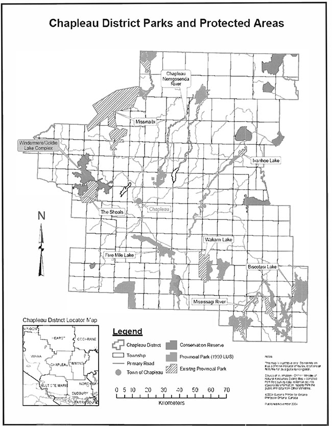
8.2: Windermere Goldie Lake Complex Conservation Reserve Boundary Map
8.3: Windermere Goldie Lake Complex Conservation Reserve Values Map
8.4: Windermere Goldie Lake Complex Conservation Reserve Vegetation Map
8.5: Windermere Goldie Lake Complex Conservation Reserve Earth Science Map
Appendix 9.1: General description of the region
Climate
Chapleau District is situated entirely within the Height - of - Land climatic region of Northern Ontario (Chapman and Thomas, 1968). The climate can be classified as continental, but is somewhat modified by elevation, and particularly in the southwestern part of the District, by the influence of Lake Superior. Most of the District’s precipitation comes in the summer and fall as a result of cyclonic storms, although thunderstorms are also important. (DLUG Background Information - p.7) The frost-free period for the town of Chapleau extends from mid June to early September, while temperatures range from a January mean of -15.6° C to a July mean of 16.7° C. (DLUG)
Characteristics of the ecoregion and ecodistrict
The Windermere Goldie Lake Complex Conservation Reserve is located in the Foleyet Ecodistrict (3E-5) which is found in the Lake Abitibi Ecoregion (3E). This region is found to contain moderately to gentle rolling bedrock, generally covered by deep deposits of clay, silt, and sand. The Ecodistrict is generally described as having rolling plains with thinly covered rock knobs, sandy outwash and silty depressions.
The Foleyet ecodistrict is characterized by gently rolling plains of thinly covered rock knobs, sandy outwash and silty depressions. Material is generally acidic (granitic), locally overlain by low-base and low lime materials. Deep deposits cover one-quarter or the area with the remaining areas being very shallow to moderately deep. At the site level the underlying granitic, volcanic and sedimentary rocks are of the Precambrian age and from them the shallow till overburden has inherited varying degrees. In the central and western portions the till overburden is richest and rocks such as greenstone occur (Cudmore, W. 2004).
Forest region
The Windermere Goldie Lake Complex Conservation Reserve is found within the Missinabi-Cabonga Section of Rowe’s (1972) Boreal Forest Region. The Missinabi Cabonga Section contains mixed forests of balsam fir, black spruce and white birch with scattered white spruce and trembling aspen. The presence of eastern red and white pine can be found on rocky shores and ridges, but only to a small degree due to past logging operations. Jack pine is situated along rivers and found in association with black spruce on poor rocky soils. Black spruce is also found in association with tamarack and white cedar in wet lowland areas.
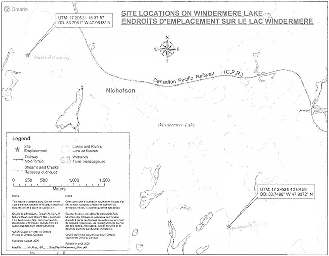
Map: Site location on Windermere Lake
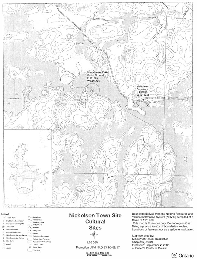
Map: Nicholson Town site cultural sites
Appendix 9.2: Summary of permitted uses
Commercial uses
| Issues and Activity | Permitted | Explanation |
|---|---|---|
| Commercial fishing - new | Maybe | New operations can be considered subject to ‘Class EA for PPCR’ |
| Commercial fishing - existing | Yes | Existing uses permitted to continue unless there are significant demonstrated conflicts |
| Commercial fishing - transfer | Maybe | Transfers will be considered within the context of the SCI, subject to the ‘Class EA for PPCR’ |
| Bait-fish harvesting - new | Maybe | New operations can be considered subject to the ‘Class EA for PPCR’ |
| Bait-fish harvesting - existing | Yes | Existing uses permitted to continue unless there are significant demonstrated conflicts |
| Bait-fish harvesting - transfer | Maybe | Requests for transfer will be dealt with on an on-going basis subject to the ‘Class EA for PPCR’ |
| Commercial bear hunting - New | No | New operations will not be permitted. New operations are defined as an activity that has not been licensed or authorized since January 1, 1992. |
| Commercial bear hunting - Existing | Yes | Existing operations will be permitted to continue indefinitely Existing operations are definled as an activity that has been licensed or authorized at any time between January 1, 1992 and June 25, 2003. |
| Commercial bear hunting - transfer | Maybe | Requests for transfer will be dealt with on an on-going basis and not deferred until the completion of a SCI or RMP |
| Commercial fur trapping - New | Maybe | New operations may be considered subject to the ‘Class EA for PPCR’, including consideration for the associated trails that may be required |
| Commercial fur trapping - existing | Yes | Existing uses permitted to continue unless there are significant demonstrated conflicts |
| Commercial fur trapping - transfer | Yes | Requests for transfer will be dealt with on an on-going basis subject to the ‘Class EA for PPCR’ |
| Trapping cabins - New | No | Not permitted |
| Trapping cabins - Existing | Yes | Existing use are permitted to continue, including repair and replacement, as long as the scale and function are not significantly altered. Relocation may be permitted if consisted with protection of natural heritage values. |
| Trapping cabins - transfer | Yes | Trapping cabins are included in the transfer of a commercial fur trapping licence |
| Outpost camps/tourism facilities - New | Maybe | New tourism facilities can be considered during planning |
| Outpost camps/tourism facilities - Existing | Yes | Existing authorized tourism facilities can continue unless there are significant demonstrated conflicts. Tourism facilities can apply to upgrade tenure from LUP to lease. Applications will be subject to the ‘Class EA for PPCR’ |
| Outpost camps/tourism facilities - transfer | Maybe | Requests for transfer will be dealt with on an on-going basis subject to the ‘Class EA for PPCR’ |
| Wild rice harvesting - existing | Yes | Existing uses permitted to continue unless there are significant demonstrated conflicts |
| Wild rice harvesting - transfer | Maybe | Requests for transfer will be dealt with on an on-going basis subject to the ‘Class EA for PPCR’ |
| Food harvesting - new | Maybe | New operations can be considered subject to the ‘Class EA for PPCR’ |
| Food harvesting - existing | Yes | Existing uses permitted to continue |
| Food harvesting - transfer | Maybe | Requests for transfer will be dealt with on an on-going basis subject to the ‘Class EA for PPCR’ |
Industrial activities
| Issues and Activity | Permitted | Explanation |
|---|---|---|
| Energy transmission corridors and communication corridors - existing | Yes | Permitted to continue |
| Energy transmission corridors and communication corridors - new | No | New corridors should be discouraged through planning however it is recognized that in some circumstances there will be no alternatives. |
| Commercial hydro power generation | No | Not permitted |
| Commercial timber harvest | No | Not permitted |
| Cutting of trees by leaseholders, cottagers, for fuel wood and other small-scale uses | No | The cutting of trees for non-commercial purposed is not permitted. Exceptions may be authorized by permit, subject to a review and determination of the impact that such cutting would have on natural heritage values. This flexibility is intended only for leaseholders, cottagers and other property owners who do not have road access to their property. |
| Timber salvage | Maybe | If provided for in an SCI or RMP, standing, fallen or sunken trees may be removed for resource management purposed. Such trees may be marketed if economical |
| Forest renewal in recently harvested areas | Yes | Renewal can be conducted where it will be of net benefit to the protected area. Review and approval of the proposals must be completed by appropriate silvicultural and program staff responsible for the management of the protected area in order to determine what actions would best support the long-term ecological integrity of the area. |
| Extraction of peat, soil, and aggregate | No | Not permitted |
| Mining and Mineral Exploration | No | No new exploration on untenured land is permitted. All existing mining land tenure within the conservation reserve including mining claims, leases, licenses of occupation and patents, will remain protected under the Mining Act and will be treated as any other in the Province |
| Roads - existing | Yes | Existing authorized roads can continue to be used. With regards to resource access roads, where alternative access does not exist or road relocation is not feasible, road will continue to be available for access. Continued use includes maintenance and may include upgrading. |
| Private access roads - existing | Yes | New roads for resources extraction will not be permitted except for those identified in Forest Management Plans before March 31, 1999 and for which no viable alternative exists. |
| Private access roads - new | No | Where there is no prior commitment, new private access roads will not be permitted. Where OMNR made a commitment prior to March 29, 1999, to permit a private access road within a recommended protected area, the road proposal will be subject to completion of a public planning process. |
Recreational activities
| Issues and Activity | Permitted | Explanation |
|---|---|---|
| Sport fishing | Yes | Existing and new uses permitted to continue |
| Sport Hunting | Yes | Existing and new uses permitted to continue |
| Motorized boating | Yes | Existing and new uses permitted to continue |
| Canoeing/ Kayaking | Yes | Existing and new uses permitted to continue |
| Non-trail ATV use | No | Non-trail ATV use may be permitted for direct retrieval of game only |
| Recreational Trail - existing (motorized and non-motorized) | Yes | Existing authorized trails can continue unless there significant demonstrated conflicts |
| Recreational Trail - new (motorized and non-motorized) | Maybe | New trail can be considered subject to the ‘Class EA for PPCR’ |
| Private recreation camps - new | No | Not permitted |
| Private recreation camps - existing | Yes | Existing authorized recreation camps permitted to continue and may be eligible for enhanced tenure but not for purchase of land (enhanced tenure being defined as anything beyond the term and form of current tenure). Enhanced tenure is not guaranteed and will be addressed through a screening process, such as the ‘Class EA for PPCR’ |
| Private recreation camps - transfer | Maybe | Requests for transfer will be dealt with on an on-going basis subject to the ‘Class EA for PPCR’ |
| Research | Yes | Any proposed research activity must be approved by the Area Supervisor. |
| General Walking | Yes | Existing and new uses permitted to continue |
| Photography and Painting | Yes | Existing and new uses permitted to continue |
| Wildlife Viewing | Yes | Existing and new uses permitted to continue |
| Outdoor Education/ Interpretation | Yes | Existing and new uses permitted to continue |
| Collecting | No | Collecting may only be permitted as part of an authorized research project. The issuance of permits will be considered on a per-site basis. |
Other
| Issues and Activity | Permitted | Explanation |
|---|---|---|
| Land Disposition - sale | No | Sale of land is not permitted with some types of minor exception (road allowances, installation of septic system, etc.) where it does not detrimentally affect the values and area is intended to protect. |
Footnotes
- footnote[1] Back to paragraph Boat caches on Crown land are subject to OMNR’s Free Use Policy which allows caching a noncommercial boat canoe, etc. on public land adjacent to public waterways, except on a public road, trial, access point, or portage.