Windigo Point Provincial Park Management Statement
This document provides policy direction for the protection, development and management of Windigo Point Provincial Park and its resources.
Interim Management Statement
Ministry of Natural Resources
Hon. Vincent G. Kerrio
Minister
Additional copies of this publication are obtainable only from the Ministry of Natural Resources,
Sioux Loo out District Office,
P.O. Box 309, Prince Street,
Sioux Lookout, Ontario P0V 2T0
©1989 Government of Ontario
January, 1989
Regional Director’s approval statement
This Interim Management Statement will provide interim direction for the management of the Windigo Point Provincial Nature Reserve until a comprehensive Park Management Plan is prepared.
This statement will provide the basis for the subsequent preparation of the Park Management Plan.
I am pleased to approve this Interim Management Statement for the Windigo Point Provincial Nature Reserve.
Signed by:
D. R. Johnston
Regional Director
Northwestern Region
Introduction
The purpose of this Interim Management Statement is to identify:
- park values which are to be protected
- resource management prescriptions necessary to protect these values; and
- restrictions on use of natural resources within the park
This Interim Management Statement is not intended to replace a Park Management Plan. Rather it is intended to guide the use of natural resources and related activities within the park until such time as a Park Management Plan is prepared.
Background information
| Name: | Windigo Point |
|---|---|
| Proposed Class: | Nature Reserve |
| M.N.R. District: | Sioux Lookout |
| M.N.R. Region: | Northwestern |
| Total Area (ha): | 513 ha. |
| Land: | |
| Water: | |
| Site Region: | 4S - Lake Wabigoon |
| Site District: | 4s-2 |
| Date in regulation: |
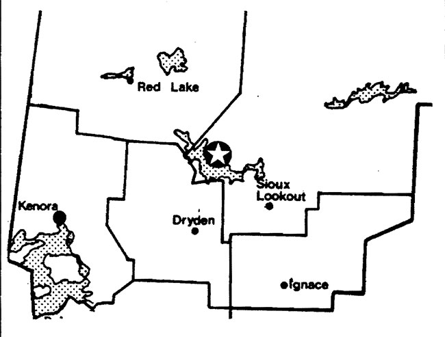
Regional Setting Map
Targets
1 Life science representation
| site type/landscape unit | species/communities |
|---|---|
| L.U. 25 - Lac Seul Basin | Southern Boreal Forest Region
|
2 Earth science representation
| geological theme | feature |
|---|---|
| N/A | N/A |
3 Cultural resource representation
| theme | theme segment |
|---|---|
| N/A | N/A |
4 Recreation opportunities
| day use | car camping | wilderness/back country |
|---|---|---|
| N/A | N/A | N/A |
Inventories
| level/ type | earth science | life science | cultural | recreational | other |
|---|---|---|---|---|---|
| reconnaissance completion date |
Dec. 1979 | ||||
| detailed completion date |
|||||
| required? | yes |
Management guidelines
I Land tenure
There are presently no alienated forms of land tenure within the park area and none will be considered pending the completion of the park management plan.
II Land acquisition/disposition
There is presently no patented land within the park area and no disposition will occur pending the completion of the park management plan.
III Existing/proposed development
There is no existing development within the park and none will be considered pending the completion of the park management plan.
IV Recreation activities
Sport hunting, fishing and a limited amount of camping occur along the shoreline of Lac Seul within the vicinity of the park.
Guideline
Sport hunting will not be permitted within the Windigo Point Provincial Nature Reserve. Enforcement will be accomplished through communication within park literature and signage along the shoreline of the park.
Camping along the shoreline of Lac Seul within the park area will be permitted to continue for Ontario residents. Non-residents of Canada are subject to the conditions of the Crown Land Camping Program which presently prohibits Crown land camping within 500 metres of Lac Seul. The Windigo Point Provincial Nature Reserve is considered to be a non-operating park and normal park fees will not apply.
V Commercial activities
A portion of one Native trapline lies within the park.
The park lies within the Lac Seul Forest Management Agreement Area.
Guideline
The above existing trapline will be permitted to continue as a non-conforming use. In the event of a request for a transfer of this licence, the area contained within the park will be excluded from the reissued licence. No trapline cabins will be permitted within the park.
Timber Harvesting is not permitted in the park area. The park has been excluded from the Lac Seul Forest Management Agreement Area. This situation will be reflected in all management and operating plans that cover the park area.
No other commercial activities will be permitted pending the completion of the park management plan.
VI Natural resources
The primary life science value within this nature reserve is a large stand of red pine at the extreme range limit for this species as detailed in the attached check sheet. Interim management efforts will be directed towards the protection of this life science value.
Due to the proximity of the park to forest harvesting areas and the susceptibility of the park values to fire, all fires within the park will be subject to initial attack and fire suppression efforts. Fire suppression techniques used will have as minimal effect as possible on the park environment. Such means of suppression as bulldozing, helipad locations, fire camps, and waterbombing with chemical additives will not be permitted except in critical situations.
VII Research
A more complete and detailed life science inventory will be necessary prior to the preparation of the park management plan.
Research activities that will enhance our scientific and resource knowledge of the park will be encouraged.
VIII Native interests
The park lies within the Treaty #3 area. Status Indians enjoying treaty rights to carry on traditional natural resources harvesting activities will be permitted to carry on those activities in accordance with the terms of their treaty within the Windigo Point Provincial Nature Reserve. Accordingly such Status Indians will be permitted to carry on those activities in certain circumstances. The details of those circumstances will be the subject of further discussion and review.
IX Cultural resources
There are no known cultural resources within the park area.
Sources/references
Gray, Stephen L. 1980. Life Science Systems Planning Report West Patricia land Use Plan.
Harvey, E.T. 1980. Earth Science Systems Planning in the West Patricia Planning Area, Final Report.
Harvey, T., S. L. Gray, B. Thacker 1980. Landscape Units of the West Patricia Land Use Planning Area
Ontario Ministry of Natural Resources, Backgrounder -District Land Use Guidelines, June 1983.
Table IV
Source: Backgrounder
District Land Use Guidelines
OMNR, 1983
Recommended nature reserve candidates
Uses recommended to continue prior to and after regulation
| Name | MNR Region | Size (ha) | Mineral Exploration/ Development | Hunting | Trapping | Commercial Fishing | Bait Fishing | Other |
|---|---|---|---|---|---|---|---|---|
| 1. Trout Lake* | NW | 7,850 | Phase out | |||||
| 2. Windigo Point* | NW | 380 | Phase out | |||||
| 3. Lola Lake | NW | 6,350 | Yes | Yes | Yes | Yes | ||
| 4. Butler Lake | NW | 3,290 | Yes | Yes | Yes | |||
| 5. Bonheur | NW | 720 | ||||||
| 6. Minitaki Kames* | NW | 4,340 | Phase out | |||||
| 7. Sable Island | NW | 1,800 | Yes | Yes | Yes | |||
| 8. Gameland | NW | 2,200 | Yes | Yes | Yes | Yes | ||
| 9. Nelles Township | NW | 800 | Yes | Yes | Yes | |||
| 10. Blue Township | NW | 1,600 | Yes | Yes | Yes | Yes | ||
| 11. West Bay | NC | 1,140 | Yes | |||||
| 12. Windigo Bay | NC | 8,300 | Yes | Yes | ||||
| 13. Sedgeman lake | NC | 5,800 | Yes | Yes | Wild Rice | |||
| 14. Edward Island | NC | 530 | Yes | |||||
| 15. Kiashk/Gull River | NC | 230 | ||||||
| 16. White Fish lake (W) | NC | 1,150 | ||||||
| 17. White Fish lake (E) | NC | 190 | Yes | |||||
| 18. Thompson Island | NC | 170 | Yes | |||||
| 19. Craig’s Pit | NC | 480 | Yes | Yes | Yes | Yes | ||
| 20. Matawin River | NC | 2,650 | Yes | Yes | ||||
| 21. Pantagruel Creek | NC | 2,200 | Yes | |||||
| 22. Kab River | NC | 1,970 | Yes | Yes | ||||
| 23. Fraleigh lake | NC | 870 | Yes | Yes | ||||
| 24. Devon Road Mesa | NC | 90 | ||||||
| 25. Pigeon River Clay Plain | NC | 2,870 | Yes | Yes | ||||
| 26. Prairie River Mouth | NC | 290 | Yes | Yes | Yes | Yes | ||
| 27. Gravel River | NC | 790 | Yes | Yes | Yes | Yes | ||
| 28. Arrowhead Peninsula | NC | 490 | ||||||
| 29. Pie Island Mesa | NC | 50 | ||||||
| 30. Red Sucker Point | NC | 380 | Yes | Yes | Yes | Yes | ||
| 31. Kama Hill | NC | 1 | ||||||
| 32. Puff Island | NC | 2 |
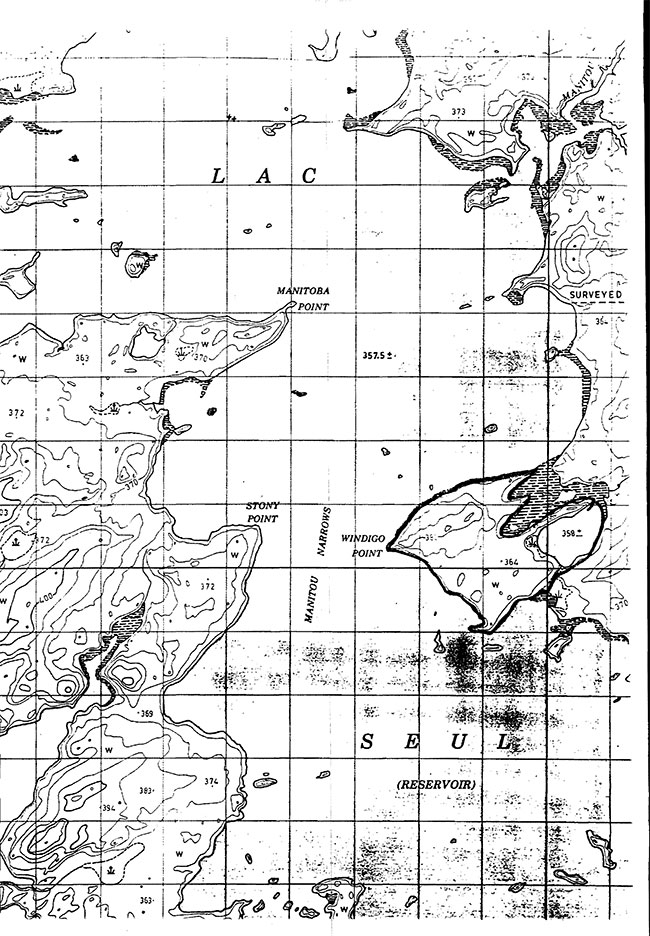
Windigo Point Provincial Nature Reserve map
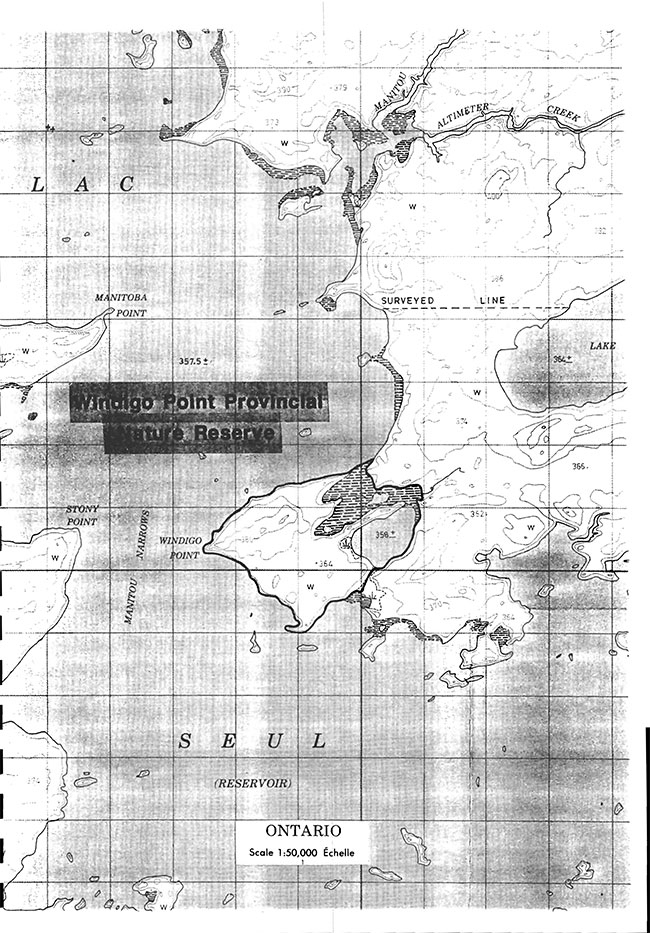
Enlarge Windigo Point Provincial Nature Reserve map
Ontario Nature Reserves Program - Life Science Inventory Check-Sheet
| Name | Windigo Point - Red Pine Stand |
|---|---|
| Map Name | McIntyre Bay |
| Map Number | 52K/7 |
| UTM Ref. | 190800 |
| County, District or Regional Municipality | District of Kenora |
| Latitude | 50°23'N |
| Longitude | 92°44'W |
| Altitude Minimum | 357 m |
| Altitude Maximum | 390 m |
| Locality | Lac Seul |
| Township | |
| Lots | |
| Concessions | |
| Area | 1200 acres, 480 ha |
| Ownership | |
| Administration | |
| Forest Region and District | B. 11-U. English R. |
| Site Region and District | 4S-2 (Lac Seul) |
| MNR Region and District | NW- Sioux Lookout |
| Aerial Photographs Year/ Roll/ Flight Line/ Numbers |
Base Map: 503923/504923 |
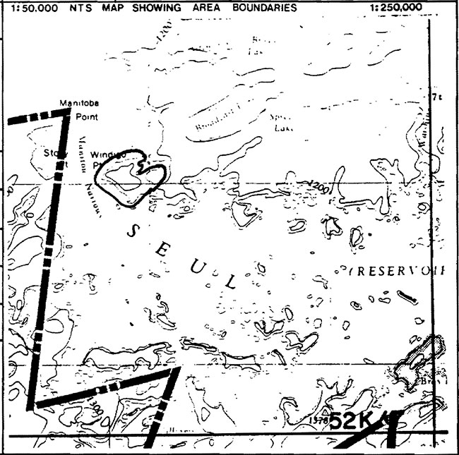
1: 50,000 NTS Map Showing Area Boundaries
Physical and biological features
A large stand of red pine is located on Windigo Point which juts out into Lac Seul. This stand is located on the extreme range limit for this species as its occurrence at this latitude is somewhat sporadic. Haddow (1948) indicates isolated stands as occurring in the Red Lake, Lac Seul and Lake St. Joseph area with this site on Windigo.Point being one of the locations. Haddow also refers to the fact that the "largest stand of red pine is on Thaddeus Lake". This stand was not visited in the field so it is not known if it still exists.
The pine stand at Windigo occurs within a landscape consisting of weakly broken lacustrine clay and sand deposits. Although not verified in the field, the actual deposits supporting this stand may be glacio-fluvial ice contact material (eskerkame?) that have been modified by lake action. The spatial form of these deposits is that of a large knoll which slopes the lake on all sides. Some cutting has occurred here which has left scattered clumps of red pine. The red pine is regenerating except in small clearings where balsam fir is prolific.
Data sheets attached
Physical description
Vegetation summary
Evaluation sheet
Community Descrs.
Community comp. lists
Summary species lists
Physical features map
Vegetation map b
Bibliography
Photographs
Major information sources
Haddow, 1948. Jour. Arnold Arb. Vol. 29.
Evaluation and priorities
This site is of life science significance and should be protected.
Date compiled: December 4, 1979
Compiler: T. Noble
Ontario Ministry of Natural Resources, Division of Parks, Park Planning Branch, Queens Park, Toronto, Ontario, M7A 1W3
| Substrate and temperature | Regime | Arid | Dry | Dry | Mesic | Mesic | Mesic | Wet | Wet | Rated | Water |
|---|---|---|---|---|---|---|---|---|---|---|---|
| Colder | Rock | ||||||||||
| Colder | Sand | ||||||||||
| Colder | Loam | ||||||||||
| Colder | Clay | ||||||||||
| Colder | Organic | ||||||||||
| Normal | Rock | ||||||||||
| Normal | Sand | ||||||||||
| Normal | Loam | ||||||||||
| Normal | Clay | ||||||||||
| Normal | Organic | ||||||||||
| Warmer | Rock | ||||||||||
| Warmer | Sand | A | A | ||||||||
| Warmer | Loam | ||||||||||
| Warmer | Clay | ||||||||||
| Warmer | Organic |
A Closed Coniferous Forest - sand
Note: More site types exist here than indicated above. Field work would be required to more accurately describe the area.
Windigo Point Provincial Nature Reserve Site Map