Geographic profiles
The final section summarizes the forest using geographic profiles and discusses the underlying geography and climate that affects Ontario's forests.
There are many ways to subdivide Ontario geographically. For example, depending on what you want to explore you might use ecological or watershed boundaries, or administrative boundaries such as ownerships, forest or wildlife management units, or even electoral districts.
The following summaries show the area of productive forest for all Ontario by ownership using several commonly referenced subdivisions. These summaries use satellite data rather than detailed FRI summaries.
Rowe's forest regions
J. Stan Rowe was a geo-ecologist who worked for Forestry Canada and the University of Saskatchewan. In 1959 he wrote Forest Regions of Canada
which is perhaps one of the most commonly used systems to describe Canadian forests. The boundaries used in this version of The Forest Resources of Ontario
are still based on the 1972 version of Rowe's map, however; improved mapping standards means they vary slightly from those used previously.
Each forest region is characterized by its climate, forest ecosystems and wildlife species. North-south gradients in temperature and east-west gradients in precipitation largely determine the extent of these forest regions.
Most of Ontario's population lives within the Great Lakes – St. Lawrence and Deciduous forest regions. The managed forest zone is almost exclusively on the Boreal and Great Lakes – St. Lawrence forest regions.
| Region | Crown | Parks & protected areas | Other owners | Total |
|---|---|---|---|---|
| Hudson Bay Lowlands | 5,793,762 | 358,022 | 45,603 | 6,197,386 |
| Boreal Forest | 31,349,666 | 4,147,278 | 1,660,326 | 37,157,270 |
| Great Lakes St. Lawrence | 6,477,499 | 1,540,213 | 4,459,210 | 12,476,922 |
| Deciduous | 3,833 | 7,091 | 454,876 | 465,800 |

Ecological land classification - Ecoregions
In the 1950s, Angus Hills developed the first comprehensive, hierarchical, ecological land classification system for describing ecosystems using climate and geological landforms. In 2009 the we revised Ontario's ecological land classification system and published “The Ecosystems of Ontario, Part 1: Ecozones and Ecoregions”.
| Ecoregion | Crown | Parks & protected areas | Other owners | Total |
|---|---|---|---|---|
| 0E - Hudson Bay Coast | 168,540 | 98,130 | 563 | 267,234 |
| 1E - Northern Taiga | 1,963,335 | 82,904 | 12,241 | 2,058,479 |
| 2E - James Bay | 3,083,146 | 53,959 | 22,065 | 3,159,170 |
| 2W - Big Trout Lake | 9,404,402 | 671,983 | 158,736 | 10,235,122 |
| 3E - Lake Abitibi | 9,759,643 | 856,515 | 1,047,418 | 11,663,576 |
| 3S - Lake St. Joseph | 3,879,704 | 925,767 | 34,940 | 4,840,411 |
| 3W - Lake Nipigon | 5,603,291 | 1,155,426 | 301,307 | 7,060,024 |
| 4E - Lake Temagami | 2,675,097 | 521,044 | 187,820 | 3,383,961 |
| 4S - Lake Wabigoon | 3,303,462 | 663,016 | 213,171 | 4,179,649 |
| 4W - Pigeon River | 965,637 | 377,730 | 193,602 | 1,536,968 |
| 5E - Georgian Bay | 2,725,263 | 577,165 | 2,186,809 | 5,489,237 |
| 5S - Agassiz Clay Plain | 53,280 | 12,036 | 126,925 | 192,240 |
| 6E - Lake Simcoe - Rideau | 38,464 | 51,033 | 1,853,431 | 1,942,928 |
| 7E - Lake Erie - Lake Ontario | 1,498 | 5,895 | 280,986 | 288,379 |

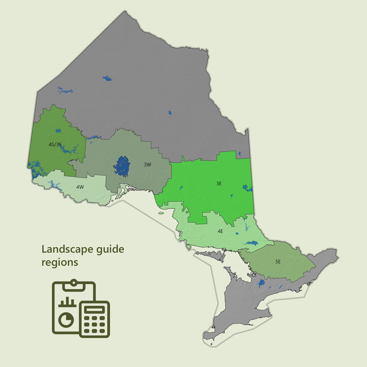
Landscape guide regions
In Ontario, landscape guide regions are groupings of management units that approximate ecoregion boundaries. They represent the geographic context of the Boreal and Great Lakes Landscape Guides used in forest management planning.
Visual display
Tables and supporting data are available on the Ontario Data Catalogue. To support representation of complex data, a variety of tables, charts and maps are available in a visualization format.
View data visualization – Landscape metrics
| Landscape guide region | Crown | Parks & protected areas | Other owners | Total |
|---|---|---|---|---|
| 3E | 8,996,039 | 779,039 | 929,163 | 10,704,241 |
| 3W | 7,017,848 | 1,214,808 | 162,882 | 8,395,539 |
| 4E | 3,807,211 | 740,816 | 1,080,790 | 5,628,817 |
| 3S/4S | 4,282,024 | 856,194 | 199,149 | 5,337,366 |
| 4W | 2,116,042 | 462,005 | 542,294 | 3,120,341 |
| 5E | 1,487,760 | 361,136 | 1,565,673 | 3,414,568 |
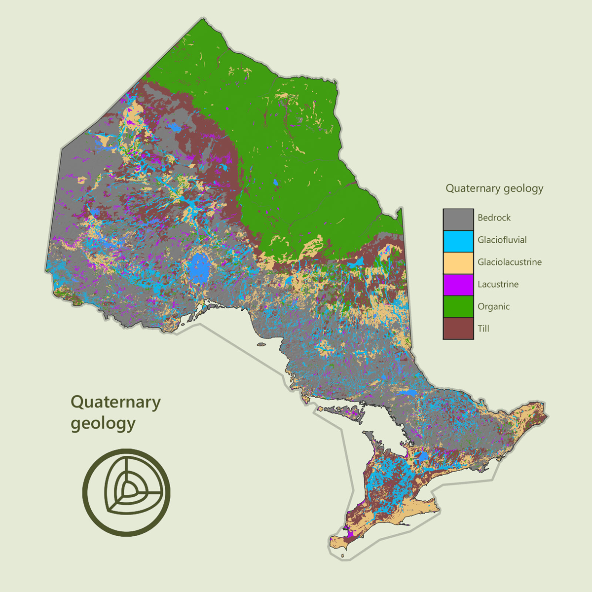
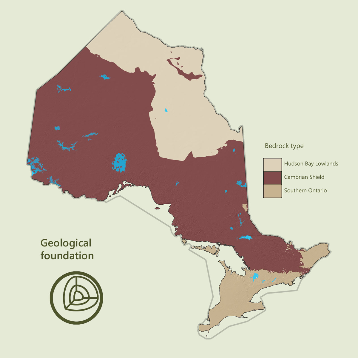
A base for forests - geology and climate
Ontario lies on a foundation of bedrock and sedimentary rock that are among the oldest in the world.
The Cambrian Shield (often referred to as the Canadian Shield) is dominated by shallow soils and granite bedrock that stretch from the northern end of the Great-Lakes through to the Hudson Bay Lowlands. The Cambrian Shield accounts for 66% of Ontario's area and contains approximately 86% of Ontario's productive forests.
North and south of the Cambrian Shield lay areas of limestone sedimentary rock formed over 438 million years ago. The Hudson Bay Lowlands have strong influences of climate and organic soil cover that limit forests to mostly slow growing black spruce. Southern Ontario is a highly productive area that is now dominated by agriculture and urban settlement.
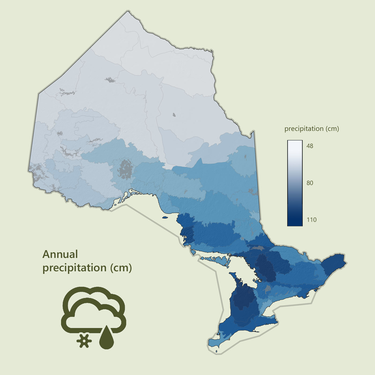
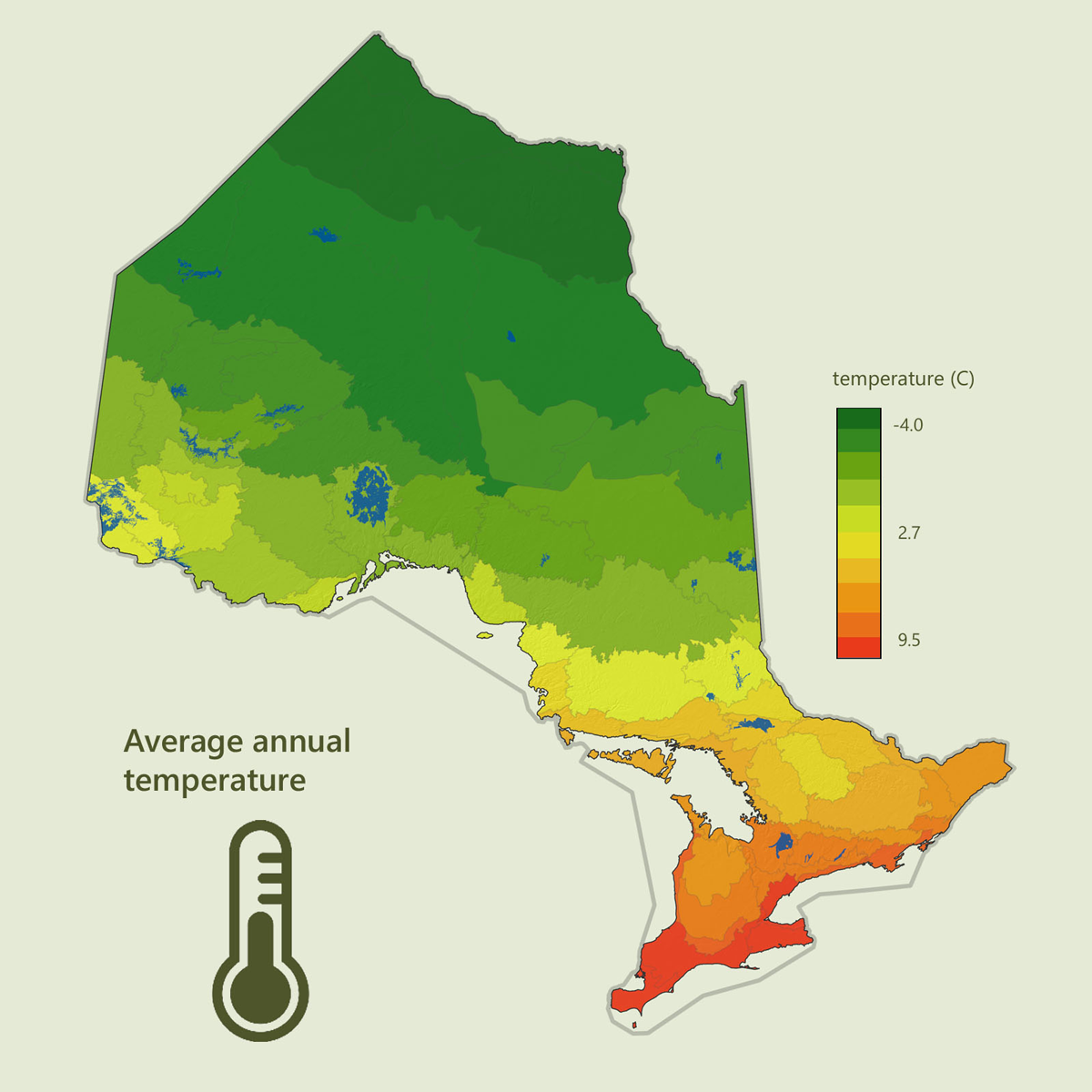
Climate influences Ontario's forests in a complex pattern. The interaction of climatic factors and soil characteristics has a dramatic impact on the tree species found in any given area. Ontario's climate is most affected by cold polar air from Hudson Bay and the prairies, and warmer air from the Gulf of Mexico.
The Great Lakes also have a profound influence on Ontario's weather. The relationship between forest soils, climate and forest vegetation is known to be important to forest management. Broad soil and ecosystem classifications are tracked as part of forest resources inventory products.
The climate maps below are average values from 1981 to 2010 by ecodistrict as provided by Natural Resources Canada - Regional, national and international climate modeling Natural Resources Canada Climate Modeling.