Part I: Policies for Crown land planning processes — 2.0 Crown land use planning in Ontario – Overview and context
2.1 Role of MNRF in land and resource management
MNRF manages forests, fish, wildlife, Crown lands and waters, aggregates, petroleum and salt resources to promote the responsible use of Ontario’s natural resources. As part of this management, MNRF strives to maintain healthy and diverse natural resources and ecosystems that are resilient to change and provides leadership in the development and application of geographic information. MNRF protects life, property and natural resources from the effects of forest fires, floods and drought.
2.2 Crown land use planning overview
Crown land use planning assigns Crown lands and waters to specific land use designations with associated general policies, determines the specific uses that may occur in land use areas, and/or establishes broad direction for the land uses. Crown land use planning interprets and applies broad government policies and objectives in the context of local conditions and values.
To arrive at sound decisions for allocating and managing Ontario’s natural resources, MNRF employs a variety of planning processes that:
- differentiate among policy decisions (e.g. strategic planning and land use planning) and management decisions (e.g. resource management plans)
- provide partners and the general public with opportunities to participate in and influence the development of strategic, land use and resource management decisions
- provide Indigenous peoples with opportunities to participate in and influence the development of strategic, land use and resource management decisions in ways that consider the traditions and approaches of Indigenous communities, and address any applicable legal obligations for Indigenous community consultation
- provide a record of the natural resource issues, objectives, information, analyses and outcomes considered in and resulting from natural resource planning and decision making
- rely on science and best available information to support decisions
- ensure consistent approaches are applied when decisions are made at various spatial scales
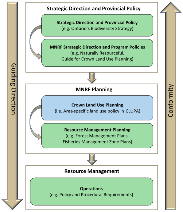
The relationship of MNRF’s Crown land use policy and planning to MNRF’s broad policy, planning and management system is represented in Figure 2. This figure shows how Crown land use policy and planning is directed and influenced by other sources of policy and direction, including government priorities, legislation, MNRF strategic direction and MNRF program policies. Crown land use policy and planning in turn provides direction for a variety of resource planning and management processes carried out by MNRF and partners. As shown in Figure 2, each level conforms with the direction in the level above it. The role of legislation, policy and government direction in developing Crown land use policy and planning is discussed in Section 7.1.
Land use policy plays an important role in:
- ensuring the orderly allocation and management of Ontario’s Crown lands and resources
- applying government and ministry policy that involves the allocation and sustainable management of land providing context for more detailed resource management planning and the planning of projects and activities and communicating how land use policies apply to local areas
Crown land use planning under the PLA
Section 12 of the PLA is the legislative basis for Crown land use planning, and authorizes the Minister to:
- establish policies and guidelines for land use planning (s. 12.1 (1))
- designate an area of public lands to be planned - referred to as a planning unit. A planning unit cannot include lands defined as a planning area for the purposes of the Far North Act, 2010 (s. 12 (1))
- require that a plan be prepared for a planning unit (s. 12 (2)) in accordance with any established policies or guidelines (s. 12.2 (1))
- approve a land use plan (s. 12.2 (2))
- amend a land use plan at any time in accordance with any established policies and guidelines (s. 12.2 (3))
Section 12 also provides:
- that all activities carried out in a planning unit shall be consistent with an approved land use plan (s. 12.3 (1))
- that the Minister may by order require a person to stop any activity that is not consistent with a land use plan (s. 12.3 (3))
In the Guide, a “land use plan” includes:
- policy reports published in CLUPA
- documents that are primarily intended to provide area-specific land use policy
- land use amendments
Activities that must be consistent with a land use plan under s. 12(3) of the PLA may include commercial activities (e.g. forestry, aggregate extraction, mineral exploration and development), land and resource management activities (e.g. Crown land disposition, road development and maintenance), recreational activities (e.g. hunting, fishing) and associated facilities and infrastructure (e.g. road use). Activities are not limited to those activities carried out by MNRF under the authority of the PLA and include activities on Crown land authorized under any Act, including Acts administered by other ministries. Activities carried out by agencies of the Crown, as well as any third parties, must be consistent with the approved land use plan.
An outcome of a Crown land use planning process may put conditions or restrictions on an activity that is not administered under the PLA. In this situation, it is important that during the planning process MNRF has engaged and sought endorsement from other ministries with legislative responsibility for that activity. Upon approval of the land use amendment, the conditions or restrictions would be documented in the planning document and may require implementation through the appropriate ministry. For example, if a land use decision were to restrict hunting in a certain area, the decision would be documented in the land use amendment but would also require a change to the Hunting Regulations under the Fish and Wildlife Conservation Act. Where land use restrictions related to mineral exploration and development were adopted MNRF would engage with ENDM to implement and effect the restrictions through Mining Act provisions and approvals, as required.
Standard:
Activities carried out on Crown lands shall be consistent with any general and area-specific land use policies that have been approved by MNRF.
Community based land use planning under the Far North Act (2010)
The Far North Act, 2010, established a legislative basis for community based land use planning in the Far North to be carried out jointly between First Nation communities and Ontario.
Approved community based land use plans are included in the Crown Land Use Policy Atlas (CLUPA). Unlike the area south of the Far North boundary however, CLUPA is not the primary source for area-specific land use direction in the Far North. In the Far North, community based land use plans are the source of all area-specific land use direction, not CLUPA. Effectively, CLUPA provides a summary of permitted uses and related direction in CLUPA policy reports that is open and accessible to First Nations, planners and the public.
As community based land use plans are the primary source of land use direction in the Far North, and are prepared, approved, and amended in keeping with the Far North Act, amendments to community based land use plans are not subject to the amendment policies in the Guide (Section 5.3). When community based land use plan information is added to CLUPA it is done through an administrative amendment. These administrative amendments are posted on CLUPA and serve as a means of notifying the public that there has been an update to an existing community based land use plan, or that a new community based land use plan has been approved.
All Far North documentation for display in CLUPA is consistent with CLUPA mapping and presentation standards.
2.3 Principles for Crown land use planning processes
The following principles should be considered in any evaluation of planning processes. The principles are focused on planning processes, whereas other policies provide direction for the desired outcomes.
MNRF’s strategic direction outlined in Ministry of Natural Resources & Forestry Strategic Plan 2020-2025: Naturally Resourceful outlines the Ministry’s mission to sustainably manage and promote the responsible use of Ontario’s natural resources. These resource stewardship principles, which reflect the Ministry’s Statement of Environmental Values (SEV) under the Environmental Bill of Rights, must be considered in MNRF’s Crown land use planning.
Crown land use planning principles include:
Aboriginal and treaty rights:
Ontario is committed to meeting its constitutional obligations in respect of the Aboriginal and treaty rights of Indigenous peoples. Ontario has a duty to consult with Indigenous peoples where its actions may adversely affect an established or credibly asserted Aboriginal or treaty right.
Broad perspectives:
Land use decisions should consider implications for both the broader landscape and the longer term. As part of the broader perspective, the potential cumulative effects of land use decisions should be considered.
Efficient:
Planning processes should be designed to achieve useful outcomes while considering the time and effort required by both participants and the government.
Informed:
Planning decisions should be informed by scientific and traditional knowledge, social values and interests, and thorough analysis. Local and traditional ecological knowledge includes Indigenous traditional ecological knowledge and other local knowledge. Planning decisions need to consider the ecological, social, and economic context and implications.
Integrated:
Decision making should be integrated where possible, either through making interdependent decisions together, or coordinating related processes. Integration also involves considering a broad range of policies and objectives, using an interdisciplinary approach and working with other organizations on land use issues.
Involvement:
Meaningful, flexible and effective opportunities for involvement should be provided in planning processes. Planning processes should engage a range of perspectives in order to identify solutions that, wherever possible, have broadly-based support. Appropriate engagement provides opportunities for Indigenous peoples to be involved in matters that may affect their communities.
Respectful relationships:
Provide opportunities for reconciling relationships and building constructive, co-operative partnerships with Indigenous peoples.
Responsive:
Planning is an ongoing process that needs to respond to changing conditions, improved knowledge, ongoing assessment of the results of previous decisions, and updated policies.
Transparent:
Crown land use planning processes should provide access to relevant information, identify the potential consequences of options, and document reasons for decisions.
Strategic focus:
MNRF should focus its planning resources on initiatives that are likely to make the greatest contribution to the achievement of broad government objectives and MNRF’s strategic directions.