
Report a fire

To report forest fires in the Northwest and Northeast fire regions north of the Mattawa and French rivers and represented by a solid colour in the map, call a 310-FIRE. To report a wildland fire (including grass, brush and forest fires) call 310-FIRE (3473)

To report forest fires South of the French and Mattawa Rivers and represented by diagonal lines in the map, call 911. South of the French and Mattawa rivers call 911.
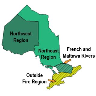
The Northwest Region is north and west of Sault Saint Marie, the east region is east of Sault Saint Marie, areas south of Owen Sound and Ottawa are outside the fire region.

Interactive fire map

Real time updates.

Our interactive map visually shows active fires, current fire danger across the province and restricted fire zones in effect.

The map now shows perimeters for some fires over 40 hectares in size. Note that not all fires are mapped and perimeters are not updated every day (may differ from the size reported in the table).

Most of the data used in the Interactive Map is available on Ontario GeoHub.

We recommend using Google chrome as your web browser to access the map.

Ontario's fire season starts April 1

Aviation, Forest Fire and Emergency Services reminds the public that outdoor fire rules are in effect throughout Ontario’s legislated fire season, which runs from April 1 to October 31. To dispose of yard waste and woody debris, we encourage the use of alternatives such as composting or utilizing your local landfill. If you must burn, use caution and follow the rules outlined in Ontario’s Wildland Fire Management regulation.

Fires are to be ignited no sooner than 2 hours before sunset and extinguished no later than 2 hours after sunrise. Always ensure you have adequate tools and water available to contain the fire at the site. Know the rules for safe outdoor burning. Read the full set of outdoor fire rules.

Residents within municipal boundaries must also check with their local fire department for burning restrictions or permitting requirements prior to burning.

Wildland Fire Management Act

Effective April 1, several regulatory changes come into effect as a result of updates to the Wildland Fire Management Act. These amendments will help to ensure greater awareness of rules designed to prevent unwanted human-caused fires and include:

  • A new Ontario Regulation 44/26 (Administrative Penalties) to establish a framework for issuing administrative monetary penalties for contraventions of the Act or its regulations, generally before a wildland fire has occurred.
  • Replacing the Outdoor Fires regulation with the Ontario Regulation 43/26 (Wildland Fire Management) to clarify, streamline, and reduce permit requirements.
  • Amendments to the existing cost recovery regulation.
  • Updates to short form wordings in an existing regulation.

These amendments will help modernize wildland fire management and protect Ontario communities throughout current and future wildland fire seasons. To learn more about the updates now in effect, keep an eye out for our social media posts this month or visit the Wildland Fire Management Act webpage found on e-Laws.

Learn more about the regulations.

Forest fire updates

Northeast Region

Updated: July 13, 2026 at 7:00 p.m. Eastern Daylight Time (EDT)

No new wildland fires were confirmed in the Northeast Region today.

Two wildland fires were confirmed last night after the update was issued:

  • Wawa 15 (WAW015) is 0.7 hectares in size and is not under control. This fire is located on the eastern shore of Lake Superior in Lake Superior Provincial Park approximately 1 kilometre south of Laughing Brook Creek.
  • Chapleau 10 (CHA010) is 2.1 hectares in size and is under control. This fire is located approximately 1 kilometre southeast of Sunnyside Beach Road, north of the Sault Ste Marie Airport.

There are currently 29 active wildland fires in the Northeast Region. Of these fires: 1 is not under control, 1 is being held, 2 are under control and 25 are being observed.

To access the current forest fire danger rating in your area visit our interactive fire map.

Northwest Region

Updated: July 13, 2026 at 9:40 p.m.  Central Daylight Time (CDT)

A total of 31 new wildland fires were discovered in the Northwest Region by the evening of July 13.

Fort Frances Sector
  • Fort Frances 38 (FOR038) is located north of Hwy. 11 near Duck Lake, approximately 26 kilometres east of Atikokan. The 5.0 hectare fire received air attack July 13 and is not under control.
  • Fort Frances 37 (FOR037) is located north of Crooked Lake in Quetico Provincial Park, approximately 61 kilometres south of Atikokan, the 5-hectare fire is being observed.
  • Fort Frances 36 (FOR036) is located near French Lake, approximately 36 kilometres east of Atikokan. The 0.2 hectare fire is being held.
Sioux Lookout Sector
  • Sioux Lookout 89 (SLK089) is located near Hill Lake, approximately 19 kilometres north of the Ojibway Nation of Saugeen. The fire is not under control at 55 hectares.
  • Sioux Lookout 88 (SLK088) is located near Doghole Lake, approximately 8 kilometres southwest of Mishkeegogamang First Nation. The fire is not under control at 0.2 hectares.
  • Sioux Lookout 87 (SLK 087) is located on an island on Lake of Bays, approximately 40 kilometres southeast of Sioux Lookout. The fire is not under control at 0.2 hectares.
  • Sioux Lookout 86 (300 hectares) and Sioux Lookout 85 (0.3 hectares) - are located near Pashkokogan Lake, approximately 18 and 22 kilometres south of Mishkeegogamang First Nation, respectively.
  • Sioux Lookout 84 (SLK084) is located near DeLesseps Lake, approximately 71 kilometres south of Mishkeegogamang First Nation. The 143-hectare fire is not under control.
Dryden Sector
  • Dryden 36 (DRY036) is located near Lower Moosehide Lake, approximately 21 kilometres southwest of Ignace. The fire is not under control at 60 hectares.
  • Dryden 35 (DRY035) is located near Weaver Lake, approximately 72 kilometres north of Upsala. The fire is not under control at 500 hectares.\
  • Dryden 34 (DRY034) is located near Harmon Lake, approximately 28 kilometres south of the Allanwater Bridge. The fire is not under control at 400 hectares.
  • Dryden 33 (DRY033) is located on a southern peninsula of Eagle Lake, approximately 11 kilometres southwest of Migisi Sahgaigan First Nation. The fire is not under control at 3 hectares.
  • Dryden 32 (DRY032) was located adjacent Hwy. 647 near Blue Lake Provincial Park. The fire was called out at 0.1 hectares.
Thunder Bay Sector
  • Thunder Bay 59 (THU059) is located near the northern shore of Lake Nipigon, approximately 35 kilometres east of Armstrong. The fire is not under control at 0.2 hectares.
  • Thunder Bay 58 (THU058) is located approximately 2 kilometres south of Pallisades Rd. near the junction of Moore Rd. The 1.0 hectare fire received air attack from waterbombers this afternoon. The fire is not under control.
  • Thunder Bay 57 (THU 057) is located approximately 5.5 kilometres north of Whitefish Lake. The fire is not under control at 0.5 hectares.
  • Thunder Bay 56 (THU056) is located near Wawang Lake, approximately 41 kilometres north of Upsala. The 400-hectare fire is not under control.
  • Thunder Bay 55 (THU055) is located near Smoothrock Lake in Wabakimi Provincial Park, approximately 37 kilometres northwest of Armstrong. The fire is not under control at 5 hectares.
  • Thunder Bay 54 (THU 054) is located near Brett Lake, approximately 59 kilometres west of Gull River First Nation. The 400-hectare fire is not under control.
  • Thunder Bay 53 (1.0 hectare), Thunder Bay 50 (25 hectares) and Thunder Bay 49 (0.1 hectare) are located west of Caribou Lake in Wabakimi Provincial Park, approximately 21 kilometres north of Armstrong.
  • Thunder Bay 52 (THU052) is located east of Wabakimi Provincial Park, approximately 37 kilometres north of Armstrong. The fire is not under control at 0.1 hectares.
  • Thunder Bay 51 (THU 051) is located approximately 6.3 kilometre northwest of Whitefish Lake, the 9.0 hectare fire received air attack from waterbombers, July 13. The fire remains not under control.
Nipigon Sector
  • Nipigon 40 (NIP040) is located near Opichaun Lake, approximately 42 kilometres south of Fort Hope First Nation. The 1.0 hectare fire is not under control.
  • Nipigon 39 (0.5 hectares) and Nipigon 38 (1.5 hectares) are located near Sollas Lake, approximately 38 kilometres northwest of Aroland. Both fires are not under control.
  • Nipigon 37 (NIP037) is located south of Toronto Lake, approximately 61 kilometres west of Aroland. The 35 hectare fire is not under control.
  • Nipigon 36 (NIP036) is located near the north shore of Miminiska Lake, approximately 56 kilometres west of Fort Hope First Nation.
  • Nipigon 35 (NIP035) is located south of Luella Lake, approximately 72 kilometres southwest of Fort Hope First Nation. The 150-hectare fire is being observed.

At the time of this update there are 128 active wildland fires in the Northwest Region. Of those fires, 53 are not under control, 8 fires are being held, 4 fires are under control 63 fires are being observed. A total of 4 fires were called out today.

To access the current forest fire danger rating in your area visit our interactive fire map.

Fires of note

Fort Frances 14
  • Fort Frances 14 (FOR014) is located approximately 35 kilometres southwest of Upsala near Byers Lake.
  • The fire is now measuring 1,749.7 hectares and is not under control.
  • There are 13 FireRanger crews, 10 Type-2 fire fighting crews, and 12 helicopters assigned to suppression operations
  • Increased fire behaviour was observed today as hot, dry conditions persist.
  • Ground crews and bucketing helicopters were supported throughout the day by CL-415 waterbombers.
  • A NOTAM is now in effect over the fire area.
Fort Frances 15
  • Fort Frances 15 (FOR015) is located in Quetico Provincial Park, south of Pickerel Lake.
  • The fire is now measuring 1,751.9 hectares and is not under control.
  • Increased fire behaviour was observed today as hot, dry conditions persist. Smoke is visible in the area.
  • Quetico Provincial Park has issued a closure in parts of the park. Details can be found on their webpage.
Restrictions in effect

NOTAM - Fort Frances 14     
There is currently a NOTAM in the area of wildland fire Fort Frances 14, northeast of Byers Lake.

This is over and above the standard airspace restrictions imposed by Section 601.15 of the Canadian Aviation Regulations (CARs) which state that the airspace around all active forest fires is restricted to forest fire suppression aircraft only, specifically airspace within 5 nautical miles, up to an altitude of 3000 feet above ground level.

Pilots are reminded that NOTAMs concerning forest fires can be found on NavCanada’s Collaborative Flight Planning Services under the ‘Weather and NOTAM’ tab, when flight planning.

NOTAM - Nipigon 16        
There is currently a NOTAM in the area of wildland fire Nipigon 16 near Kasabonika Lake First Nation.

This is over and above the standard airspace restrictions imposed by Section 601.15 of the Canadian Aviation Regulations (CARs) which state that the airspace around all active forest fires is restricted to forest fire suppression aircraft only, specifically airspace within 5 nautical miles, up to an altitude of 3000 feet above ground level.

Pilots are reminded that NOTAMs concerning forest fires can be found on NavCanada’s Collaborative Flight Planning Services under the ‘Weather and NOTAM’ tab, when flight planning.

Restricted fire zones

Due to the high to extreme fire hazard, increased wildland fire activity, the current fire load and to reduce the number of human-caused wildland fires, the Ministry of Natural Resources will be implementing a Restricted Fire Zone (RFZ) effective July 15 at 12:01 a.m. local time for the Northwest Region and a small portion of the Northeast Region.

The areas impacted are from the corner of the borders of the USA, Manitoba and Ontario , north along the Manitoba and Ontario border to a point southwest of the Echoing River, then southeast in a straight line to roughly 40 kilometres northeast of the community of Kitchenuhmaykoosib, then east to a point roughly 73 kilometres northwest of the community of Attawapiskat, then south to roughly 12 kilometres south of Highway 11, then west to the northeast tip of Sandlink Lakes, then south following Sandlink Creek to Northeast Bay on McKay Lake, following the eastern shore of McKay Lake to the entrance of the Pic River, then south along the Pic River to Lake Superior Canada/US border in Lake Superior. This order is required to reduce the number of human-caused wildland fires. We are expecting the current fire hazard to remain, along with the potential for problematic fires to continue and expect a continuation of the increased forest fire activity into the foreseeable future.

No open air burning, including campfires, is permitted within the boundaries of a Restricted Fire Zone.  Portable gas or propane stoves may be used for cooking and warmth but must be handled with extreme caution.  All burning permits are suspended. The Restricted Fire Zone will be in place until further notice.

Review Restricted Fire Zone Map here

If your municipality has also imposed a fire ban, you must comply with both the restricted fire zone (RFZ) and municipal fire ban.

Contact information

Northeast Region

Isabelle Chenard
Fire Information Officer
705-564-6156

Alison Lake
Fire Information Officer
1-888-220-7242

Northwest Region

Chris Marchand
Fire Information Officer
1-888-258-8842

Shayne McCool
Fire Information Officer
705-507-0509

Social media

Check out our Facebook, Instagram and X (formerly Twitter) accounts for safety tips and other wildland fire related information.

For highway conditions, including road closures, call 511 or visit 511on.ca

For air quality in your area, visit:
public weather alerts for Canada

For smoke drift conditions across North America, visit:
smoke drift across North America

For information about wildland fire smoke and your health, consult:
smoke and your health

Fires: year to date

These figures represent the year-to-date total number of wildland fires inside Ontario’s fire region for the 2026 fire season, as they compare to the 2025 season and to the 10-year average.

  • 416
    fires in 2026
  • 344
    fires in 2025
  • 303
    10-year average

Fire bans in provincial parks

For all park fire bans visit:
Ontario parks alerts
Fire Ban icon

You are responsible for fires you light

From April through October, people using outdoor fires must follow strict guidelines under the Wildland Fire Management Act of Ontario to ensure their fires are properly managed.

Anyone who starts a fire outdoors must take all necessary steps to tend the fire, keep it under control and make sure the fire is out before leaving the site. A person failing to burn safely could be fined and held responsible for the cost of putting out the fire. People living in municipalities should check with local fire officials for bylaws on outdoor fires.

Hunters

  • Check the interactive fire map to find out where the active wildland fires are in Ontario.
  • Be aware of FireRangers who may be working in wildland areas.
  • Check your surroundings for FireRanger activity before discharging your firearm to help keep everyone safe.

About Aviation, Forest Fire and Emergency Services (AFFES)

Visit our forest, wildland and outdoor fires page for more information on AFFES and wildland fire management, including: