Chapter 2 The planning basis
2.1 General
2.1.1 This implementing plan details the response to an emergency at the Darlington Nuclear Generating Station (DNGS).
2.1.2 DNGS is located in the Municipality of Clarington at latitude 43°52' North and longitude 78°43' West, on the northern shore of Lake Ontario.
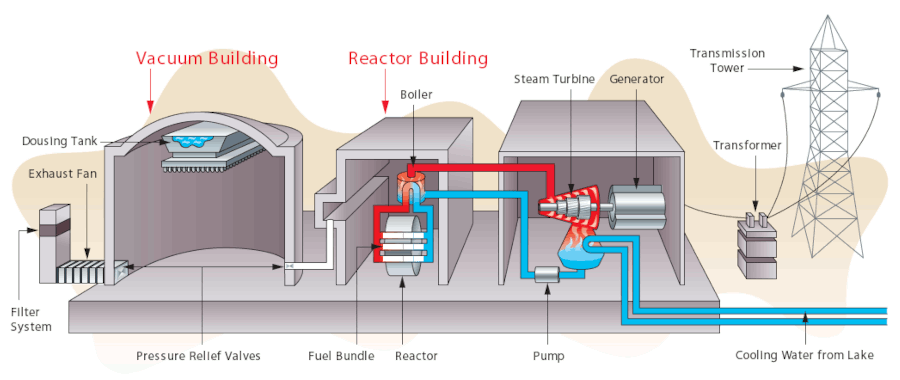
2.1.3 The Darlington nuclear facility consists of one power generating station with four Canada Deuterium Uranium (CANDU) nuclear reactors, each having an electric power generating capacity of 881 megawatts. The installation also contains a Tritium Removal Facility, which is housed in a portion of the heavy water (D2O) management building, a separate structure from the main nuclear generating station. Figure 2.1 shows a schematic diagram of a CANDU reactor.
2.1.4 Referencms in this document to the Darlington Nuclear Generating Station (DNGS) or the Darlington station include the Tritium Removal Facility unless stated otherwise, or the context indicates otherwise.
2.2 The hazard
2.2.1 If an accident were to occur at DNGS, the most probable result would be that its effects would be confined within the station boundary because of the facility's designed safety systems, structures and components.
2.2.2 Nuclear emergency preparedness requires a planning basis which considers both design basis accidents, and significantly less probable beyond design basis accidents (BDBAs), including severe accidents and multi-unit scenarios where applicable. For a detailed explanation regarding the basis for these reference accidents, refer to PNERP Master Plan, Annex L- PNERP Planning Basis Background.
2.2.3 Design Basis Accidents (DBA)
- The DBA release provides the main platform for detailed planning and is generally characterized by one or more of the following:
- Station containment systems function normally allowing radiation to start decaying prior to a controlled release.
- Sufficient time would be available to alert the public and implement protective measures prior to a release.
- The main radiological hazard to people would be external exposure to, and inhalation of, radionuclides.
- Filter systems function to remove almost all of the radioactive particulate and radioiodine. As a result, the plume would be mostly composed of inert noble gasses which would dissipate and do not pose a contamination hazard.
- Radiation doses to the public would likely be below the generic criteria as defined in PNERP Master Plan, Annex E.
- Environmental contamination would be limited to very low levels.
- Low-level radioactive releases to the environment could occur on and off for some time (e.g., days or weeks).
- An example of a design basis accident scenario is a Loss-of-Coolant Accident (LOCA), with the following typical progression:
- The reactor building would “box-up” preventing any immediate releases. A “box-up” is a condition whereby all possible release pathways to the environment, such as ventilation stacks, are closed.
- Duct connections from the reactor building to the vacuum building would open, thereby reducing the former's internal pressure to below atmospheric pressure, drawing radioactive material released from the damaged reactor fuel into the vacuum building. During this hold-up time (e.g., 7 days) the contained radioactivity would decay.
- If at any stage the pressure in the containment system nears atmospheric pressure, the contained radioactivity may be vented through filters to the environment. Such venting could be intermittent or continuous but may last for weeks (see Section 4.6.6). The level of radioactivity being released would progressively decline with time.
- Suitable meteorological conditions may make it possible to vent some of this contained radioactivity through filters in a direction away from populated areas. It may be possible to do this several times.
2.2.4 Beyond Design Basis Accidents (BDBA)
- One or more of the following may define a BDBA:
- Station containment systems may be impaired leading to significantly reduced hold up time and decay of radioactive materials.
- An early release of radioactivity from a BDBA with limited warning time.
- An uncontrolled release of radioactivity from a BDBA with limited warning time.
- The plume could include radioiodine and particulates along with noble gases.
- Radiation doses could potentially be high.
- Environmental contamination could be quantitatively significant in both extent and duration.
- The area affected could extend beyond the Detailed Planning Zone.
- A multi-unit accident (i.e., an accident involving more than one reactor).
- BDBAs which go unmitigated may evolve into severe accidents involving fuel degradation in the reactor core.
- The response to BDBAs, including severe accidents, is facilitated by dedicated emergency mitigating equipment in addition to the measures already in place to respond to DBAs (see 2.2.3 above) and the ability to expand their function.
- The following additional planning and preparedness actions shall be conducted to mitigate the much less probable, but possibly more severe, off-site effects of BDBAs:
- pre-distribution of Potassium Iodide (KI) pills (see Section 5.3.3)
- automatic, default actions to initiate public alerting (see Section 6.2) and to direct the implementation of protective actions, including sheltering-in-place (see Section 5.3.4) and evacuation (see Section 5.3.1)
- timely dispatch of aerial and ground monitoring teams to determine areas of contamination (see Section 4.7.3)
- priority evacuations for those closest to the hazard (see Section 5.3.1)
- extension of protection actions to the Contingency Planning Zone (CPZ), if required, to reduce potential for exposure
- radiation monitoring and, if necessary, decontamination of persons (see Section 6.9)
- medical assessment, treatment and counselling as required (see Section 6.9)
2.2.5 Tritium Removal Facility (TRF)
- The radiological hazard from an accident at the TRF could arise from the release to the environment of tritium, tritiated water, and tritiated water vapour.
- The airborne pathway could carry tritium gas and tritiated water vapour in the downwind direction, thus creating a potential hazard from external exposure to, and inhalation of radioactive material.
- The waterborne pathway could carry tritiated water into the lake (either directly or after draining into the ground), thus creating a potential hazard from the ingestion of radioactively contaminated water or fish. Such a liquid release from the TRF shall be dealt with as prescribed in the Provincial Liquid Emission Response Procedure.
2.3 Protective actions
2.3.1 The protective actions available for minimizing the radiation hazard in a nuclear emergency include:
- precautionary measures
- exposure control measures
- ingestion control measures
2.3.2 These measures are listed in Table 2.1 below and defined in the glossary (Annex D).
2.3.3 The operational use of these measures is described in appropriate sections of this plan.
Table 2.1 Protective actions for a nuclear emergency response
| Precautionary measures | Exposure control measures | Ingestion control measures |
|---|---|---|
|
|
|
2.4 Planning zones
2.4.1 Automatic Action Zone (AAZ)
- The AAZ is a pre-designated area immediately surrounding a reactor facility where pre-planned protective actions would be implemented by default on the basis of reactor facility conditions with the aim of preventing or reducing the occurrence of severe deterministic effects.
- The DNGS AAZ is the area immediately surrounding the reactor facility extending out to an approximate radius of 3 kilometres.
- The Automatic Action Zone comprises Detailed Planning Zone (DPZ) response sector D1 (see Figure 2.2) and includes an area adjacent to the DNGS boundary from Courtice Road to Martin Road and extending north to Darlington Baseline Road.
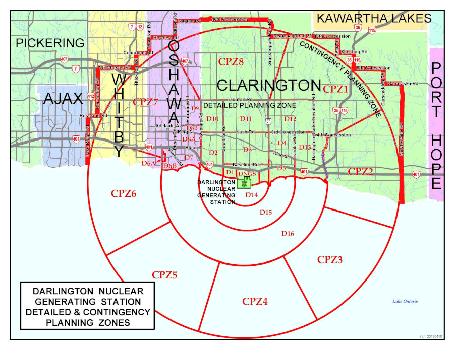
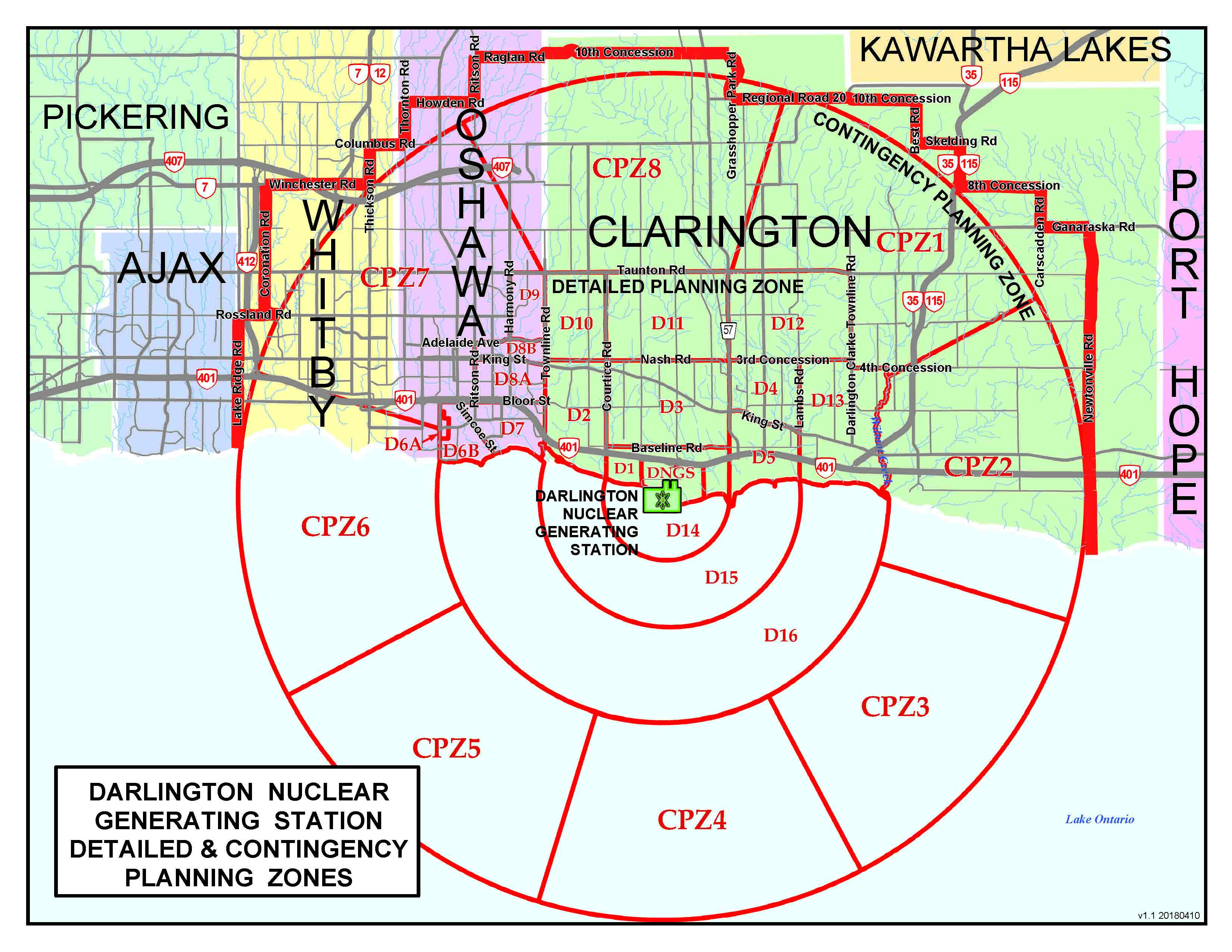
2.4.2 Detailed Planning Zone (DPZ)
- The DPZ is a pre-designated area surrounding a reactor facility, incorporating the Automatic Action Zone, where pre-planned protective actions are implemented as needed on the basis of reactor facility conditions, dose modelling, and environmental monitoring, with the aim of preventing or reducing the occurrence of stochastic effects.
- The DNGS DPZ is the area immediately surrounding the reactor facility extending out to an approximate radius of 10 kilometres.
- The Detailed Planning Zone for DNGS is shown in Figure 2.2. It includes an area of the Regional Municipality of Durham bounded generally by Taunton Road to the north, Wilmot Creek to the east, and Park Road (RR 54) to the west. The zone extends southward into Lake Ontario to a radius of 10 km from DNGS. The exact boundaries of the zone can be determined from Annex A.
2.4.3 Contingency Planning Zone (CPZ)
- The CPZ is a pre-designated area surrounding a reactor facility, beyond the Detailed Planning Zone (see 2.4.2 above), where contingency planning and arrangements are made in advance, so that during a nuclear emergency, protective actions can be extended beyond the Detailed Planning Zone as required to reduce potential for exposure.
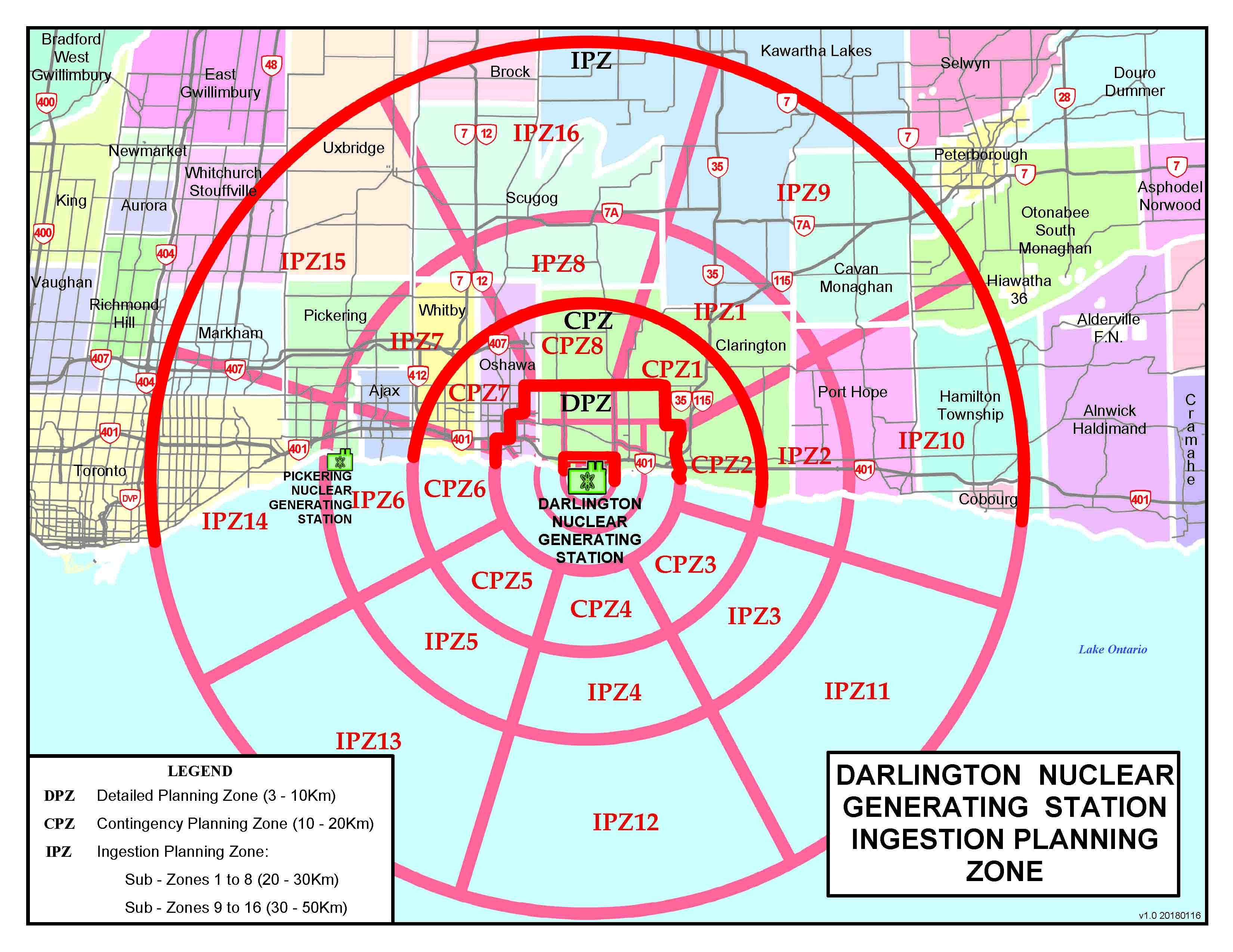
- The DNGS CPZ is shown in Figure 2.3 and includes the area between 10 and 20 kilometres surrounding the reactor facility.
- Additional CPZ guidance is provided in Annex C.
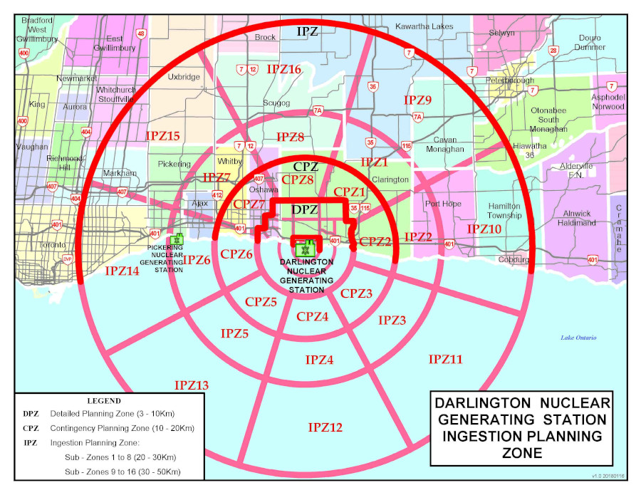
2.4.4 Ingestion Planning Zone (IPZ)
- The IPZ (see Figure 2.3) is a pre-designated area surrounding a reactor facility where plans or arrangements are made to:
- protect the food chain
- protect drinking water supplies
- restrict consumption and distribution of potentially contaminated produce, wild-grown products, milk from grazing animals, rainwater, animal feed
Note: Wild-grown products can include mushrooms and game.
- restrict distribution of non-food commodities until further assessments are performed
- The DNGS IPZ encompasses all areas of Durham Region, the City of Toronto, York Region, the City of Kawartha Lakes, Northumberland County and Peterborough County that lie within a 50 km radius of DNGS. The Ingestion Planning Zone includes the Automatic Action Zone, Detailed Planning Zone and Contingency Planning Zone. Figure 2.3 also shows the sub-zones of the Ingestion planning zone.
2.5 Response sectors
2.5.1 The Detailed Planning Zone for DNGS is divided into 16 response sectors which fall into the following sector rings around the station:
- Automatic Action Zone: Sectors D1 and lake sector D14
- Inner Ring: Sectors D2 through D5 and lake sector D15
- Outer Ring: Sectors D6A, D6B, D7, D8A, D8B, D9, D10, D11, D12, D13, and lake sector D16
2.5.2 The boundaries of the DPZ response sectors are shown in Figure 2.2, and are detailed in Annex A.
2.6 Planning data, interface and support
2.6.1 Planning times for radioactive emissions
- The time interval between the occurrence of an accident at DNGS and the commencement of an emission depends on the condition and functioning of the station containment system and on the effectiveness and timing of the actions taken by station operators to reduce the rate of vacuum structure repressurization thus prolonging the holdup and decay of radioactive material within containment.
- For a normally functioning containment system, a minimum interval of 7 days (between the occurrence of the accident and the commencement of an emission) can be used for planning purposes.
- When controlled venting is required (see Section 4.6.6), intermittent filtered releases of varying durations could continue for many weeks.
- In the exceptional situation where the containment system was impaired, an emission could commence much earlier; in some cases, very soon after the accident and, the emission may be continuous.
2.6.2 Municipal planning data
Designated Municipality nuclear emergency plans shall detail the planning data necessary to undertake an effective nuclear emergency response. This data should be organized according to planning zones, sub-zone and response sector, and include:
- population estimates (see Annex B)
- institutional data
- critical infrastructure
2.6.3 Evacuation time estimates
- Evacuation time estimate studies shall be prepared and regularly updated to facilitate transportation planning and the management of transportation during a response.
- Evacuation time estimate studies shall be developed in accordance with NUREG/CR-7002, Criteria for Development of Evacuation Time Estimate Studies, or similar standard.
- Evacuation time estimates shall be based on current census data and future population growth projections until end of life of the reactor facility and take into consideration shadow evacuations
footnote 1 . - The Province, Designated Municipalities and reactors facilities shall agree on their respective role in the development and maintenance of public evacuation time estimates and where they are documented.
- Nuclear emergency response plans of provincial ministries, Designated Municipalities and reactor facilities shall identify:
- Their respective role in the development and maintenance of public evacuation time estimates.
- Where public evacuation time estimates are documented.
2.6.4 Interface and support
- The DNGS operator shall provide an interface and support for OFMEM in accordance with the PNERP Master Plan and regulatory requirements
footnote 2 . - For DNGS, this ensures that in the unlikely event of containment venting (see Section 4.6.6):
- There is a designated person onsite at all times with the authority for venting.
- The Province, Designated Municipalities and Canadian Nuclear Safety Commission (CNSC) are consulted before undertaking any venting activity, unless venting must be performed in an urgent manner to protect the structural integrity of containment. In such a case, every effort shall be made to inform these stakeholders as early as possible.
Footnotes
- footnote[1] Back to paragraph "Shadow evacuation" is the term used to describe when people beyond the officially declared evacuation zone who are not directly affected by a nuclear emergency choose to voluntarily leave the area.
- footnote[2] Back to paragraph Clause 2.2.4 of REGDOC 2.10.1 Nuclear Emergency Preparedness and Response.
- footnote[3] Back to paragraph Nuclear Generating Unit Schematic - CANDU Pressurized Heavy Water Reactor is a generic diagram.