Chapleau-Nemegosenda Rivers Park management statement
This document provides policy direction for the protection, development and management of Chapleau-Nemegosenda Rivers Park and its resources.
Approval statement
December 11, 2017
I am pleased to approve the Chapleau-Nemegosenda Rivers Provincial Park Management Statement as the official policy for the management of this provincial park. The plan reflects the intent of the Ministry of Natural Resources and Forestry, Ontario Parks to protect the significant natural and cultural heritage values of Chapleau-Nemegosenda Rivers Provincial Park. Furthermore, the plan indicates Ontario Parks’ continued vision for Chapleau-Nemegosenda Rivers Provincial Park to provide opportunities for ecologically sustainable recreation for residents of Ontario and visitors to the province in a semi-remote setting.
This document outlines the site objectives, policies, actions and implementation priorities related to managing the park’s natural, cultural and recreational values and summarizes the involvement of Indigenous communities, the public and stakeholders that occurred as part of the planning process.
The Chapleau-Nemegosenda Rivers Provincial Park Management Statement will be used to guide the management of the park over the next 20 years. During that time, the management statement may be examined to address emerging issues or changing conditions, and may be adjusted as the need arises.
I wish to extend my sincere thanks to all those who participated in the planning process.
Yours truly,
Bruce Bateman, Director
Ontario Parks
Date: October 30, 2017
Executive summary
Chapleau-Nemegosenda Rivers Provincial Park is a waterway class park that links two parallel Arctic headwater rivers in Northeastern Ontario. It protects extensive wetlands, small lakes, and forest habitats in a semi-remote recreational setting. The park extends 120 kilometres along the Chapleau and Nemegosenda rivers, north of Highway 101. The park is located approximately 400 kilometres northwest of Sudbury and is a two-hour drive from Wawa.
Chapleau-Nemegosenda Rivers Provincial Park was established in 1973 and has been expanded four times. A fifth addition has been recommended to meet the 200-metre water’s edge setback standard established for waterway class parks. Once regulated, this addition will increase the size of the park by over 4000 hectares from its current area of 17,732 hectares.
The traditional canoe routes, portages, and campsites allow visitors to experience the park’s natural and cultural heritage. The park protects provincially, regionally and locally significant landform-vegetation combinations that are not well represented in other protected areas in Ecodistrict 3E-5. Maintaining ecological integrity is the first priority in provincial park planning and management.
This management statement describes the park’s purpose, vision, objectives, values and pressures, permitted uses, zoning, and implementation priorities. The following describes key management direction for the park.
- Industrial activities (e.g., logging and mining) are prohibited.
- No new roads or trails are permitted. Park access will be managed through two access zones in the park and two canoe-route access points that are outside the park. Unauthorized roads and trails will be closed.
- Motorized land vehicles are not permitted in the park. Exceptions occur for licenced trappers if authorized by the park superintendent, and also for a gated commercial road that is administered by a land use permit and associated conditions.
- Hunting is not permitted in historical and access zones, or in the area of the park overlapping the Chapleau Crown Game Preserve.
- Trapping is not permitted in access zones, in Frog Lake Historical Zone 2 or in the area of the park overlapping the Chapleau Crown Game Preserve.
- Motorized boating is not permitted in Riparian Cedar Wetlands Natural Environment Zone 4 with an exception for licenced trappers if authorized by the park superintendent.
- Aircraft landings for land tenure holders on Schewabik Lake and the Nemegosenda River will be permitted.
- The park superintendent will design and implement a boat cache program.
- Ontario Parks may undertake a cultural heritage assessment of park waterways in partnership with Indigenous communities to document values and establish deeper contextual knowledge for the park.
This management statement was prepared in accordance with the Provincial Parks and Conservation Reserves Act, 2006, other pertinent legislation, applicable park policy, and the planning process established in the Ontario’s Protected Areas Planning Manual and associated guidelines. Indigenous communities, stakeholders and interested public were invited to comment on the preliminary management direction for the park. Their comments and input were carefully considered during the preparation of this approved management statement.
This management statement replaces the 2006 interim management statement for Chapleau-Nemegosenda Rivers Provincial Park. It will guide the management of the park over the next 20 years. It may be amended as necessary, in consultation with Indigenous communities, stakeholders and the public.
1. Introduction
Chapleau-Nemegosenda Rivers Provincial Park is a waterway class park that links two medium-sized rivers, extensive wetlands, small lakes, and forest habitats in a semi-remote recreational setting in Northeastern Ontario. The park protects the natural and cultural heritage values of both the Chapleau and Nemegosenda rivers, and through protection, it provides semi-remote recreation opportunities. The park infrastructure is the traditional canoe route with portages and campsites. To better reflect the two significant waterways protected by the park, the name will be changed in regulation to Chapleau-Nemegosenda Rivers Provincial Park.
Chapleau-Nemegosenda Rivers Provincial Park is an ideal example of a low-use waterway class park. Waterway class parks are based on outstanding recreational water routes, and they focus on protection of aquatic and associated shoreline environments.
This management statement is written with a 20-year perspective with a purpose, a vision and objectives, a description of values and pressures, and direction on permitted uses, zoning, implementation priorities, research and monitoring. This management statement replaces the interim management statement that was released in 2006.
1.1 Planning context
This management statement is consistent with purpose, principles and objectives outlined in the Provincial Parks and Conservation Reserves Act, 2006 (PPCRA). Direction is also consistent with Ontario Provincial Parks: Planning and Management Policies (OMNR 1992) and Ontario’s Living Legacy Land Use Strategy (OLL LUS), where applicable. Management will also be in accordance with other pertinent legislation (e.g., Endangered Species Act, 2007) and policy (e.g., A Class Environmental Assessment for Provincial Parks and Conservation Reserves).
This statement will aid in managing Chapleau-Nemegosenda Rivers Provincial Park because it is tailored to protection while describing opportunities for visitors to enjoy the park’s natural, cultural, and recreational values. Ontario Parks also promotes increased knowledge and appreciation of natural and cultural heritage, research of the significant and representative habitats as indicators of ecological change on the broader landscape (e.g., from climate change), as well as opportunities for outdoor recreation.
1.2 Location, boundary and ecological integrity
Chapleau-Nemegosenda Rivers Provincial Park extends 120 kilometres along the Chapleau and Nemegosenda rivers, north of Highway 101. The park is located approximately 400 kilometres northwest of Sudbury and is a two-hour drive from the Trans-Canada Highway at Wawa (Map 1).
Chapleau-Nemegosenda Rivers Provincial Park is within the Lake Abitibi Ecoregion and Foleyet Ecodistrict, 3E-5 (Map 1). Approximately seven percent of the ecodistrict is contained in protected areas. Ministry of Natural Resources and Forestry (MNRF) Chapleau District administers Crown land surrounding the park for resource-based land uses such as forestry, mining, recreation and tourism. The area of the park located west of the Chapleau River is overlapped by the Chapleau Crown Game Preservea 7,000 square kilometre game preserve designated in 1925. Park policies conform to those of the preserve in the area of overlap (i.e., hunting and trapping are not permitted).
The PPCRA’s leading management principle is to maintain ecological integrity. Ecological integrity exists when ecological communities and their habitats are maintained without undue human interference. The boundary of this park has been added to over the years to enhance ecological integrity. Chapleau-Nemegosenda Rivers Provincial Park was established in 1973. The park was expanded in 1980 and again in 1985. In 1999, two park additions were recommended through the OLL LUS. The Chapleau-Nemegosenda Rivers Provincial Park Addition, regulated in 2003 (P1550), protects provincially significant south-trending esker systems (Duba and Frey 2002). The Nemegosenda River Wetlands Addition, regulated in 2005 (P1546), provides protection primarily for two provincially significant wetland landform-vegetation associations that are not well represented in other protected areas within the ecodistrict (Morris 2004).
Other approved Crown land additions to the park will help reconcile the loss of a former OLL LUS recommended protected area in the ecodistrict. Once regulated, these additions will expand the park boundary from 122 metres to 200 metres on each side of the Chapleau and Nemegosenda rivers to meet Ontario Parks’ minimum boundary requirements for waterway class parks (Map 2). These additions include more of the provincially significant Nemegosenda River wetlands, and will increase the park area from 17,732 to 21,946 hectares. Management direction for these pending park additions is included in this management statement.
As a waterway class park, Chapleau-Nemegosenda Rivers is a predominantly linear protected area that helps to maintain biodiversity because it includes a variety of terrestrial and aquatic habitats that provide protected corridors for native species. Both the Chapleau and Nemegosenda rivers are oriented south to north, and the protected habitats and connectivity provided by the park could prove important for maintaining ecological integrity despite the effects of climate change.
1.3 Climate change
Climate change is occurring globally and protected areas may be found to play an important role in mitigating impacts. Assessments of changes have determined that historic rates of seasonal change and temperature variations are no longer an accurate gauge for climate and weather prediction (Ontario Ministry of the Environment 2007).
Environmental changes that are occurring will result in warmer temperatures in most areas but increases will vary seasonally and there will be more variable water levels in lakes and rivers, increased frequency of high magnitude wind and precipitation events, and greater severity of forest fires (Ontario Ministry of the Environment 2007). These changes will add stress to natural communities, which will increase the risk of disturbances and alien species introductions.
This management statement looks at how park and visitor management could help to reduce the risk of human-caused effects of climate change. Some park uses (e.g., motorized vehicles, motor boats) that may be affecting the environment may not continue to be used in the same way as they were historically.
Adapting to changes requires that park managers and visitors evaluate how to reduce activities that contribute to climate change (i.e., less reliance on fossil fuel burning vehicles that produce greenhouse gas emissions). Management is needed to reduce exposure of sensitive organisms and ecosystems to additional pressures or risks. In this management statement, mitigation and adaptation to climate change have been considered and reasonable management initiatives are presented to reduce pressures on park values so as to maintain ecological integrity.
1.4 Indigenous community involvement
Development of the Chapleau-Nemegosenda Rivers Provincial Park was of interest to five Anishinabek and Cree First Nations; all but one is located in Treaty 9. In addition, members of the Chapleau Métis Community have historically used the landscape. Management direction for the park and additions does not abrogate or derogate from the Aboriginal and treaty rights of Indigenous people.
Four First Nation communities participated in preparing this management direction: Brunswick House, Chapleau Cree, Chapleau Ojibwe and Missanabie Cree. In addition, Michipicoten First Nation, signatory on the Robinson Superior Treaty (1850), has identified traditional use in this territory. Chapleau Cree and Chapleau Ojibwe had unresolved land claims that were being negotiated at that time, however, representatives of both communities indicated during their participation on the planning team that their preferred areas for land claim settlement did not affect this park.
The four First Nation communities’ involvement in the planning process included:
- participating as planning team members, contributing knowledge about the area;
- providing updates to their respective communities;
- facilitating community meetings to obtain input and review from members; and,
- providing other levels of involvement as determined by the community and the planning team.
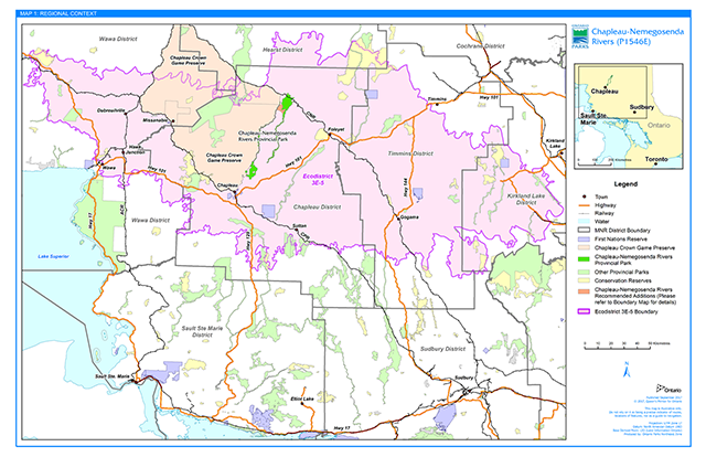
Enlarge this regional context map for Chapleau-Nemegosenda Rivers Provincial Park
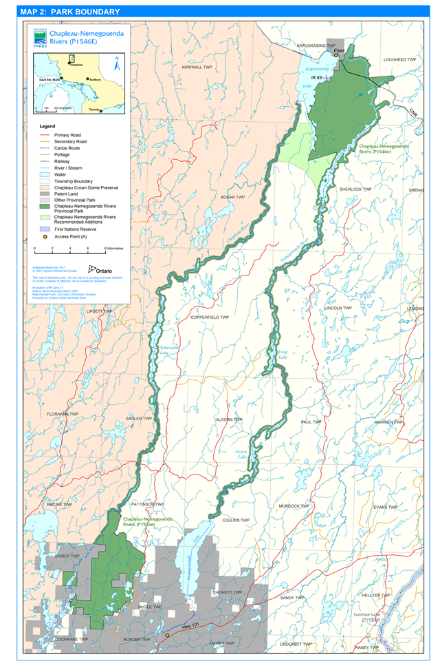
Enlarge this park boundary map for Chapleau-Nemegosenda Rivers Provincial Park
2. Purpose and vision
2.1 Purpose
Chapleau-Nemegosenda Rivers Provincial Park protects portions of two medium-sized Arctic headwater rivers that flow parallel to each other through the northern clay belt and on extensive till/outwash deposits. The rivers, wetlands and landform-vegetation associations of the southern boreal forest supported ancient travel and habitation. The rivers continue to benefit Ontario residents, Indigenous communities, and travellers from outside the province. These rivers provide numerous opportunities for ecologically sustainable recreation such as canoeing, camping, fishing and hunting in a semi-remote setting.
2.2 Vision
Chapleau-Nemegosenda Rivers Provincial Park protects significant river landscapes and cultural values along traditional travel routes north of the height-of-land in the boreal forest. Visitors enjoy canoeing, boating, camping, hunting and fishing and seeing wildlife in a semi-remote setting. This setting is particularly notable where the Chapleau River follows the edge of the Chapleau Crown Game Preserve, the world’s largest game preserve and the undeveloped natural character of the river is most evident.
3. Provincial park objectives
The park’s objectives provide an overarching basis for park-specific management interests flowing from the provincial PPCRA objectives.
Protection
Chapleau-Nemegosenda Rivers Provincial Park shall protect a traditional and current waterway route that protects cultural heritage, natural heritage, and the cultural and recreational benefits derived from these values. These values include canoe routes, pictographs, significant eskers, wetlands, fish spawning areas, and old-growth forest.
Natural and cultural heritage appreciation
Visitors shall have opportunities to learn about and appreciate the natural and cultural heritage values protected by the park.
Recreation
The park shall provide semi-remote wilderness recreation opportunities in a waterway setting and will promote sustainable recreation and associated local economic benefits. Recreational activities along the waterways include canoeing, camping, fishing, and hunting.
Scientific research
Chapleau-Nemegosenda Rivers Provincial Park provides research and monitoring opportunities for authorized persons or organizations wishing to monitor park values. As the park is made up of un-impounded, semi-remote waterways and significant natural areas, it has the potential to act as a benchmark for larger landscape comparisons. Ontario Parks will facilitate the undertaking of scientific studies compatible with protection and recreation.
4. Chapleau-Nemegosenda Rivers Provincial Park values
Chapleau-Nemegosenda Rivers Provincial Park includes a variety of earth and life-science values. It also represents traditional travel routes that are still in use today. The semi-remote wilderness setting is used by residents and tourists alike to canoe, boat, fish, hunt, camp and enjoy nature.
4.1 Natural heritage
The Chapleau and Nemegosenda Rivers are free flowing through a landscape with some of the oldest rock on the Precambrian Canadian Shield (2.5-3.4 billion years old; Ontario Geological Survey 1991). The park has significant Quaternary geology, including representations of major glacial events of the Wisconsinan period. The rivers occur in a transition region between the Great Clay Belt to the north and the extensive till/outwash deposits more characteristic of the height of land to the south.
The park is centred on two rivers with significant wetlands, mature to old-growth mixed-wood forest, as well as unique landform-vegetation associations and surficial geology (Geomatics International 1993). Thus, there are provincially, regionally, and locally significant landform-vegetation combinations that are not well represented in other protected areas within Ecodistrict 3E-5. Wetlands and forests in the park support plant species typical of the southern Boreal Forest with a few isolated patches of species generally found in the Great Lakes-St. Lawrence Forest (Foleyet Ecodistrict; Noble 1982). The river valleys in the park include provincially significant lowland tamarack and black spruce forest associations along with old-growth white cedar and regionally and locally significant open marsh/fen wetlands. There are also locally significant white pine associations, where tall trees that catch the eye on the horizon often grow on glaciofluvial esker-kettle landforms.
The variety of habitats is important for ecological integrity. For example, moose aquatic feeding areas; fish spawning, migration, and nursery areas; raptor nesting sites; a heronry (heron nesting site); waterfowl, wetland bird, and amphibian breeding habitats; and, migratory bird habitats contribute to the biodiversity found in the park.
4.2 Cultural heritage
Cultural heritage sites occur along the two traditional canoe routes with portages and campsites that have been in use for as long as people have travelled through this landscape. These rivers are representative of the extensive, interconnecting four-season travel routes that criss-cross the Canadian Shield. The waterway travel routes were used before and during the fur-trade; licenced trappers continue to use the rivers to access their traplines to this day. In addition, the rivers were important in the extensive logging history of this region as they were used to drive logs to rail sidings in the region before extensive road networks were created. Elements of the cultural history such as pictographs and the remains of historic river-drive logging structures within the park attract visitors to the area.
4.3 Recreation
Chapleau-Nemegosenda Rivers Provincial Park attracts visitors looking for semi-remote wilderness experiences. There are portions of two canoe routes with portages and campsites with access in and adjacent to the park. The larger lakes and river sections in the park are destinations for boating, fishing and hunting. Access management and zoning are vital to sustaining the park’s recreational values.
5. Managing pressures on values
5.1 Pressures
Chapleau-Nemegosenda Rivers Provincial Park is known for its semi-remote wilderness recreation opportunities. Human activities and adjacent land uses can put pressures on park values. These pressures along the length of the Chapleau and Nemegosenda rivers include unauthorized park use and unauthorized access, as well as effects from adjacent forest management operations. Other current pressures on park values include the lack of natural fire disturbance, potential conflicts between park uses, and climate change.
Potential pressures on park values include the disruption of natural water regimes of the waterways by hydroelectric developments downriver of the park, introduced invasive species, and potential disturbance of unidentified cultural heritage resources.
Park policies, zoning and site-specific management are the tools used for managing these pressures on the park’s natural, cultural, and recreational values.
5.2 Park stewardship and community partners
Park management will involve stewardship of access, canoe routes, portages and campsites to sustain park values. Community partners (e.g., trappers, outfitters, logging company, and other stakeholders, businesses and communities) will be sought to assist in providing information about the park access and use to enhance protection of park values (e.g., to reduce the risk of introducing alien and invasive species).
Working with local community partners will strengthen park stewardship. For example, the park superintendent will continue to participate in forest management planning to identify ways to mitigate potential impacts of operations on park values such as noise during peak park use, drift from herbicide application, unplanned access from roads and trails, and view-shed management. The park superintendent will also participate in the assessment of waterpower development proposals near the park: park values shall not be affected by the footprint of any new facilities downriver from the park.
Ontario Parks will monitor interior park access as part of its stewardship program. Through signage, information on the park boundary and values may be provided where visitors enter and exit the park and will include the promotion of “leave no trace” to minimize impacts on natural and cultural values. Ontario Parks welcomes partners with goals that are consistent with the PPCRA and the purpose, vision and objectives for this waterway class park. In particular, partners could fund building and/or maintaining information kiosks at access locations.
5.3 Park access
Access management is vital to protecting the quality of park natural, cultural and recreational values. Access to Chapleau-Nemegosenda Rivers Provincial Park occurs through access points and access zones (Section 5.4).
Access points are places outside the park that provide convenient and authorized access to the park, and are a first point of contact for people who travel connecting waters to get into the park. Two access points adjacent to Chapleau-Nemegosenda Rivers Provincial Park are used to get to the traditional waterway routes. They are described below, however, as they are outside the park, park policies do not apply.
North Chapleau River access point
Access to the park is from the Canadian National Railway (CNR) right of way at Elsas, one kilometre outside but adjacent to the park (Map 2).
Visitors can enter the park here from Kapuskasing Lake when travelling up or downstream on the Chapleau River and can work upstream to the Nemegosenda River within the park.
The park superintendent may seek partnerships with local interests (e.g., CNR, regional tourism association, outfitters) to establish an information kiosk at Elsas to identify best practices for visitors as they travel south and east of Kapuskasing Lake (e.g., know your route, leave no trace, reduce risk of introducing invasive species, etc.).
South Nemegosenda River access point
The South Nemegosenda River Access Point begins at Westover Lake, which is a headwater lake of the Nemegosenda River with an existing Crown land access point adjacent to Highway 101 outside the park (Map 2). Visitors travel 15 kilometres north from the access point along the Nemegosenda River and into Nemegosenda Lake before entering the park (Map 2).
The park superintendent may seek partnerships with local interests (e.g., regional tourism association, outfitters) to establish an information kiosk at South Nemegosenda River Access Point to identify best practices for visitors as they travel east and north to enter the park.
5.4 Zoning and site-specific management
Zoning organizes the park into management units based on common values and/or uses. Permitted activities by zone are derived from considering zone-specific uses in the context of park objectives, values and pressures, policies and sustainable use. Provincial park policies (general, class, and zone-specific) were applied to establish site-specific management direction. Ecologically sustainable recreational use is permitted while protecting representative or sensitive values to maintain ecological integrity of ecosystems. The site specific direction also helps retain cultural and recreational resources.
This management statement identifies four types of zones for Chapleau-Nemegosenda Rivers Provincial Park: access, natural environment, wilderness and historical (Map 3).
Park-wide policies are described in Section 6.
5.5 Access zones
Access zones are the designated land-based entry points to the park. They provide staging areas that have limited facilities to support visitor use of the park. There is one access zone where visitors can enter on the Chapleau River side of the park, and one on the Nemegosenda River portion the park. Activities involving natural and cultural heritage appreciation are permitted in access zones. These zones are a gateway for the visitor’s recreational experience, and they include boat access and staging for ice fishing.
The park superintendent may seek partnerships (e.g., logging company, outfitters, regional tourism association) to establish an information kiosk to identify best practices for visitors as they travel (e.g., know your route, leave no trace, reduce the risk of introducing invasive species). Hunting and camping are not permitted at access zones to ensure safety and equal access to park visitors.
A1 Martel (1 hectare)
Martel Road is a forest access road within the park. The road and bridge are maintained by the local forest licence holder. Over time, it has also become a road travelled for recreational purposes by locals and visitors to the area. Motorized travel over land is permitted on the road and into the access zone, but is not permitted in the adjacent natural environment zones (NE2 and NE3).
The A1 boundary is 80 metres long along the northeast side of the Martel Road and bridge over the Chapleau River. On the one side of the road only, the boundary of this access zone extends outward 40 metres to allow visitors’ parking on the side of Martel Road west of the Chapleau River crossing (Map 3). Sufficient area exists to allow vehicles with boats to park off the road.
Visitors with boats access the Chapleau River on the southeast riverbank: boats can be dragged in near the bridge. Canoeists can also access the river via the portages on both sides of the road, also back from the southeast bank of the river. Visitors usually travel downriver towards Kapuskasing Lake.
A2 North Via Rail (5 hectares)
On the west bank of the Nemegosenda River, A2 extends 20 metres out along either side of the railway right of way. On the east bank, the access zone extends out 20 metres from the right of way only on the north side of the railway. Thus, the access zone is 250 metres long on the north side of the railway, but only 120 metres on the south side (out from the west bank of the Nemegosenda River; Map 3).
This railway crossing is known as the CNR right of way (for Canadian National Railway, now known as CN) and is the bridge crossing adjacent to NE5 along the Nemegosenda River. Today, Via Rail’s The Canadian travels through the town of Elsas on its way from Toronto to Vancouver. Visitors that arrive by train can enter the park from the CN line where they access the Nemegosenda River. From there, visitors can make a short trip to Kapuskasing Lake or canoe upriver (south) towards Chapleau.
The park superintendent may work to develop partnerships with local interests (e.g., Via Rail, regional tourism association, outfitters) to establish an information kiosk to identify best practices for visitors as they enter the preferred access into the Nemegosenda River adjacent to the CN line (e.g., know your route, leave no trace, reduce risk of introducing invasive species).
The park superintendent may coordinate with Via Rail and the Ontario Ministry of the Environment and Climate Change to obtain information on emergency response procedures to determine when and how MNRF would be notified in the event of an accident.
5.6 Natural environment zones
Five natural environment zones include natural, cultural and aesthetic landscapes in which minimal development will support a variety of recreational activities (Map 3). They cover the largest proportion of the park and include the extensive linear free-flowing waterways of the Chapleau and Nemegosenda rivers.
Permitted uses include backcountry canoeing and other self-propelled land or water travel, nature appreciation, camping, sport fishing, and motor boating (except in NE4). Hunting (including bear hunting), and commercial trapping are permitted in natural environment zones except for areas of the park within the Chapleau Crown Game Preserve. No new roads or trails are permitted.
NE1 Chapleau River Uplands (4,850 hectares)
NE1 Chapleau River Uplands zone includes the Nemegosenda River Wetlands located at the south end of the park on the east side of the Chapleau River, including river and lake beds. NE1 excludes two sections of privately owned land within its perimeter: in Darcy Township and also on the west side of Adams Lake (Map 3). Subject to funding and willingness of the owners to sell, these lands may be acquired and incorporated into the park in the future if the acquisition enhances the values or management of the park. There are provincially, regionally, and locally significant landforms in this zone, including white pine-red pine, jack pine mixed woods, and open marsh/fen/bog that correspond to significant wildlife habitat.
A gated road exists through NE1 to the east of the Chapleau River and west of the bulk of NE1. The road provides access for commercial resource companies to private land outside the park for commercial resource access. The road is authorized by a land use permit (LUP) and will be maintained by the LUP holder, and rehabilitated by the LUP holder when no longer required. The LUP holder is permitted to use mechanized vehicles under their permit.
Otherwise, use of motorized land vehicles (all-terrain vehicles (ATVs), amphibious vehicles (e.g., Argo), motorcycles, snowmobiles, etc.) is not permitted in this zone.
NE2 Chapleau Game Preserve Shorelands (1,676 hectares)
NE2 includes provincially significant open marsh/fen, boreal mixedwoods, and riparian wetlands. The zone is defined by a boundary 200 metres from the water’s edge on the west side of the Chapleau River (adjacent private lands are excluded). It begins at the most southern portion on the west side of Robinson Lake and extends northward for the length of Crown lands on the west bank of the Chapleau River flowing into Kapuskasing Lake (Map 3). Motorized land travel is not permitted. NE2’s boundary follows that of the Chapleau Crown Game Preserve along the west bank of the Chapleau River, so hunting, commercial trapping and bear management operations are not permitted in this zone (Map 3). However, the Crown in the context of hunting prosecutions in 2006 took the position that a prohibition on hunting in the preserve was an unjustifiable infringement on Treaty 9 and Robinson Superior treaty rights to hunt.
NE3 Chapleau River (1,447 hectares)
NE3 values include provincially significant boreal mixed woods, jack pine-spruce-fir on glaciofluvial esker-kettle deposits, and riparian wetland on the Chapleau River, as well as associated important fish and wildlife habitat.
This zone has two separate parts. The part along the upper river begins at the northern limits of NE1 and ends at a boundary just south of the portage at the north end of Schewabik Lake (Map 3). Within this length of river the zone is defined by the high water mark on the west bank and includes the river bed and islands continuing east to a boundary defined as being 200 metres from the water’s edge on the east side of the Chapleau River.
The part of NE3 on the lower river is defined by the northern boundary of NE4, approximately five kilometres upstream of the confluence of the Chapleau River with Kapuskasing Lake. NE3 continues north, encompassing the land 200 metres on either side of the Chapleau River that are not within the Chapleau Crown Game Preserve. The northern limit of this zone is the confluence of the Chapleau River and Kapuskasing Lake (Map 3).
There is higher use in NE3 than elsewhere in the park with a full mix of users from private or Crown land tenure holders to visitors who fish, hunt, camp, motor boat and canoe. Schewabik Lake is one of the busier locations along the traditional canoe route. There is one private property on Schewabik Lake. Valid land use permits will continue. Aircraft landing is allowed for the private and land use permit holders on Schewabik Lake provided they acquire written authorization from the park superintendent each year. Schedule 2 of O. Reg. 347/07 will be amended to reflect this policy. Motorized land travel is not permitted in NE3.
NE4 Riparian Cedar and Wetlands (859 hectares)
NE4 includes regionally significant open marsh/fen with cedar shoreline patches and adjacent uplands with tall, large-diameter white pine in mixed stands. Osprey nesting sites, fish spawning and nursery habitat and moose aquatic feeding areas occur along this river section.
The zone’s southern boundary starts south of the falls and portage beginning just north of Schewabik Lake. The zone encompasses the Chapleau River bed, islands and park boundary which extends 200 metres from east side of the Chapleau River; NE4 extends from just south of the portage north of Schewabik Lake to its northern extent where shallow rapids occur in the river approximately five kilometers upstream of Kapuskasing Lake (Map 3).
Should a park cultural heritage assessment be undertaken in the future, it would identify the traditional waterway travel context for the zone. This assessment would help determine whether natural environment is the appropriate zoning or whether there is another more appropriate zone type (e.g., wilderness, historical). Any proposed changes to zoning would undergo park planning processes, including public consultation.
The management intent for this zone is to retain the semi-remote waterway condition of this portion of the Chapleau River. All types of motorized vehicles (e.g., ATVs, snowmobiles, motor boats) are not permitted in this zone. Exceptions may be made for licenced commercial trappers with authorization from the park superintendent. Schedule 1 of Ontario Regulation 347/07 will be amended to reflect motorboat restrictions in this zone. Limited access to the river maintains it as a high-quality recreational setting for those travelling the canoe route.
NE5 Nemegosenda River (5,406 hectares)
NE5 encompasses the Nemegosenda River bed and the minimum area that exists for 200 metres on either side of the river for its entire length (not including H2; Map 3). Here, provincially significant conifer associations and regionally significant open marsh/fen occur on basic Precambrian bedrock. Provincially significant white cedar associations and locally significant mixed upland forests with tall, large-diameter white pine both exist on a glaciofluvial esker-kettle landform. Biological diversity is supported by locally significant riparian wetlands and aspen dominated forests on glaciofluvial esker-kettle terrain. Significant habitats include moose aquatic feeding areas, waterfowl breeding and staging habitat, raptor nesting sites, and walleye spawning and nursery sites.
NE5 provides a largely undeveloped natural environment and protects a forested river valley with extensive riparian wetlands. With limited access, this zone will continue to offer a high quality recreation setting for recreational boaters and visitors to the five commercial outpost camps. Aircraft landing is permitted for land tenure holders accessing their property from below Alcorn Lake upstream to where the Nemegosenda River widens in Sherlock Township. Written authorization for aircraft landing will be required each year from the park superintendent. Motorized travel on the shorelands is not permitted in NE5.
Motor boating is permitted in NE5. This use will be monitored for effects on riparian wetlands. If motor boat use is found to be negatively affecting wetland aquatic vegetation, waterfowl or fish habitat, or peatlands and shorelines where eskers occur, Ontario Parks will determine mitigation measures (e.g., boat horsepower restrictions at low water levels).
Should a park cultural heritage assessment be undertaken in the future, it would identify the traditional waterway travel context for the zone.
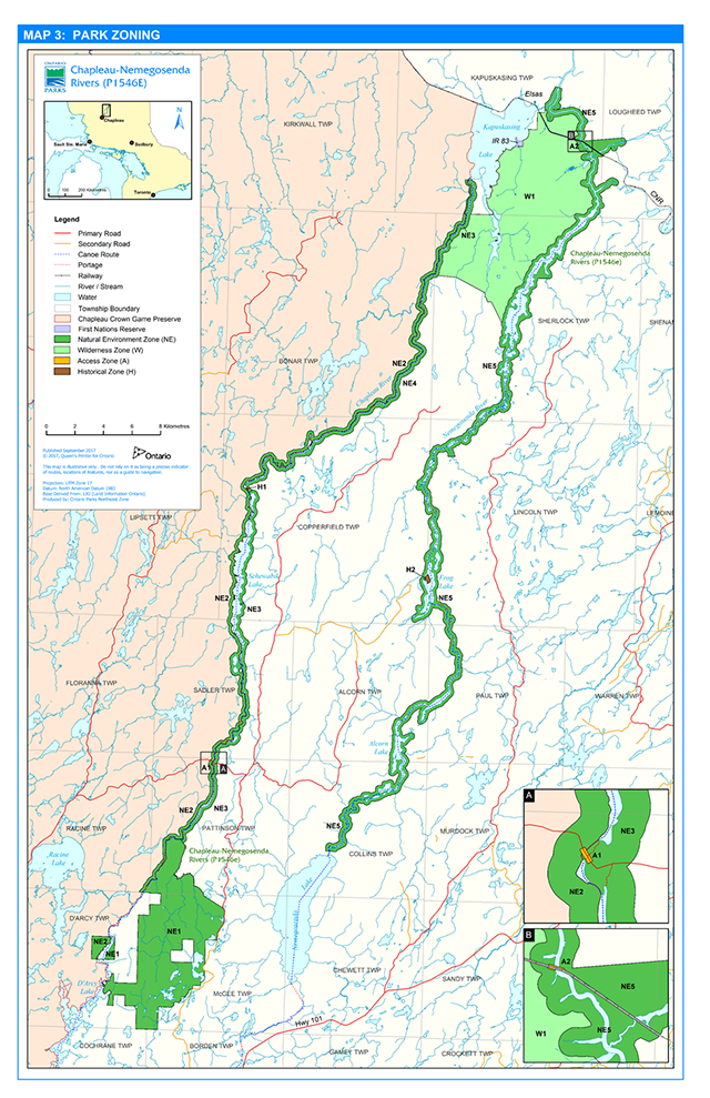
Enlarge this park zoning map for Chapleau-Nemegosenda Rivers Provincial Park
5.7 Wilderness zone
Wilderness zones include wilderness landscapes of appropriate size and integrity to protect natural and cultural values, and to support backcountry recreation. Chapleau-Nemegosenda Rivers Provincial Park’s one wilderness zone protects natural and cultural values in a large wetland-dominated roadless landscape.
W1 Nemegosenda Wetlands (7,332 hectares)
W1 encompasses the provincially significant Nemegosenda wetlands in the northern part of the park. The area’s extensive wildlife habitat includes productive waterfowl breeding and staging areas, eagle/osprey nest sites, fish spawning and nursery areas, and Moose aquatic feeding habitat. The zone is bound to the west by the Chapleau River in NE3, NE4, unregulated Crown land and Kapuskasing Lake, and to the east and north by the Nemegosenda River, NE5 (Map 3).
The Nemegosenda Wetlands Wilderness Zone will enable natural processes to function freely in a wetland-dominated landscape. Users are permitted to travel by non-mechanized means while they experience nature. Motorized vehicles including aircraft, ATV, motorcycle, amphibious vehicles (e.g. Argo), snowmobiles, and any other mechanized travel vehicles are not permitted. No new roads or trails are permitted.
Licenced trapping is permitted, as are a variety of recreational activities including canoeing, hunting, sport fishing, hiking, camping, natural and cultural heritage appreciation, photography, dog sledding, snowshoeing and cross country skiing.
5.8 Historical zones
Historical zones include significant archaeological, historical, and Indigenous values. Traditional Indigenous uses continue in these two historical zones as part of Aboriginal and treaty rights in the park. A cultural heritage assessment of the park waterways, in partnership with Indigenous communities may document values (e.g., place names, nastawgan - canoe routes and possible winter routes, campsites and portages, culturally modified trees, logging structures) to establish deeper contextual knowledge for the park.
H1 Nastawgan (1 hectare)
Nastawgan is a word still commonly used by older Ojibwa-speaking people in Ontario meaning traditional land travelways or routes. H1 is at the north end of Schewabik Lake. It includes the shorter of two portages that travel around a falls and downstream rapids. Adjacent uplands are also part of the zone on the east side of the Chapleau River and include rock ledges and a small west-facing cliff (Map 3).
This zone conserves cultural heritage values and supports traditional spiritual uses. Portaging, cultural and natural heritage appreciation, painting, and photography are permitted. Trapping may also continue. However, hunting, camping, campfires, new trails and mechanized uses are not permitted.
H2 Frog Lake (15 hectares)
H2 recognizes traditional spiritual and sacred uses and conserves cultural values. Low-impact spiritual and sacred uses, as well as cultural and nature appreciation, painting and photography are a priority in this location. This prominent east-facing headland on the western side of Frog Lake on the Nemegosenda River is only accessible by water (Map 3).
Campfires, camping, hunting, trapping, access to commercial bait harvesting areas, and new trails and roads are not permitted.
6. Park policies
This section provides broad park policies on recreational and commercial activities and management interests. Zoning and zone-specific management direction is described in Section 5.
6.1 Industrial activities
Commercial timber harvesting is not permitted.
Generation of electricity is not permitted within the park.
Extracting aggregate, topsoil or peat is not permitted, except if produced incidentally as a result of authorized construction activities and uses in the park. No such operations exist within the park at the time this management statement was prepared.
Prospecting, staking mining claims, developing mineral interests or working mines are not permitted.
6.2 Fisheries, wildlife and vegetation management
Park management practices will sustain native species and communities and maintain and/or enhance ecological integrity.
Introduction of alien species is not desirable to the health of native species and communities. Possession or introduction of any plant, animal or other living thing, or any object, material, or substance that may carry non-native or invasive pests or species is not permitted. Park management may take action to keep invasive or alien species out or to apply programs to control or eradicate invasive or alien species. Control programs will be directed as narrowly as possible to the specific alien or invasive species to have minimal effect on the ecosystem.
Fisheries and baitfish
Sport fishing is permitted within established seasons in accordance with the regulations outlined in the Ontario Fishing Regulations Summary.
Persons wishing to leave ice fishing huts unattended must comply with the PPCRA (Section 27, O. Reg. 347/07).
Fish stocking currently does not occur in the park. Fish stocking of native species by MNRF may occur in the future, and will be consistent with MNRF’s Ecological Framework for Fisheries Management, Fisheries Management Zone 8.
No commercial fishing exists within the park and no new operations are permitted.
Portions of commercial bait harvest areas CH0010, CH0011, CH0017, CHOO18, CH0034, CH0035, CH0048, CH0049, CH0050, CH0064, CH0065, CH0063, CH0077, and CH0078 overlap the park. Following approval of the provincial bait management policy, Ontario Parks will support implementing applicable changes to commercial and personal bait harvesting, possession, and use in the park.
Hunting and Bear Management Areas
The park is located within Wildlife Management Units (WMUs) 30 and 31. Where hunting is permitted in provincial parks, including hunting in Bear Management Areas (BMAs), it is regulated by the Fish and Wildlife Conservation Act 1997 (FWCA) and regulations under this Act.
Hunting is permitted in the wilderness zone, and in natural environment zones with the exception of NE2 since hunting is restricted in the Chapleau Crown Game Preserve. Hunting is not permitted in historical and access zones. Hunting regulations under the FWCA will be amended to reflect changes in areas permitted for hunting in the park. For information concerning species or open hunting seasons, contact the park superintendent.
Portions of BMAs CP31006, CP31007, CP31011, CP31013, and CP31016 occur within the park. BMAs are managed by MNRF Chapleau District. Ontario Parks will work with district staff to ensure that the no hunting policy in historical and access zones is implemented for affected BMAs CP31007, CP31011 and CP31013.
For the safety of park visitors and to maintain ecological integrity, conditions for BMA operators will appear on each Licence to Provide Bear Hunting Services relating to the portion(s) of the BMA that are in the park. Furthermore, licenced BMA operators shall discuss these conditions and specifics of their operation with the park superintendent before authorization can be granted under the PPCRA for certain bear management activities in the park.
The superintendent may work with districts to amend the boundaries of BMAs. Should this occur, BMA licence fees will be adjusted, if warranted. Ontario Parks will notify BMA operators of potential amendments to BMA boundaries due to park zoning policies or other restrictions. No new bear management operations are permitted.
Tree stands may be used associated with licensed hunting. However, no permanent structures are permitted. Temporary tree stands may be erected at the beginning of the hunting season and must be removed at the end of the season.
Trapping
Traplines that intersect the park include CP3, CP7, CP07, CP15, CP16, CP21, CP30 and CP38.
Trapping may continue except in access zones, H2, and in NE2 where trapping is prohibited in the Chapleau Crown Game Preserve. Trapline boundaries will be adjusted to reflect the no trapping policy in H2, A1 and A2 when licences associated with CP7, CP15 and CP 30 are revoked, surrendered or transferred.
Existing trap cabins are permitted and can be maintained under the authority of a work permit.
With written authorization from the park superintendent, trappers may use motorized vehicles in the park on their existing trails to access and operate their trapline.
Use of motorboats to access traplines is permitted. In NE4, written authorization from the park superintendent is required for motorboat use. Boat caches used by trappers will be evaluated and those necessary for trapline operations and not negatively impacting park values will be managed through the boat cache program.
New commercial trapping operations, and new trap cabins and trails are not permitted. The park superintendent may consider trail relocation to mitigate negative impacts or for operational needs.
Vegetation
Commercial vegetation harvest including wild rice and non-timber forest products such as berries, tree sap, mushrooms and fiddleheads will not be permitted. Standing, fallen or sunken trees will not normally be removed unless authorized by the park superintendent. Fuelwood permits will not be issued.
Natural disturbance from fire, blow down, native insects or disease will normally be left to recover naturally. However, vegetation management may occur in access zones for visitor safety.
The park superintendent will continue to participate on forest management planning teams to mitigate potential impacts of operations outside the park on park values (e.g., drift from herbicide application, unplanned access from roads and trails, view-shed management).
6.3 Forest fire management
Forest fire management will be consistent with the Wildland Fire Management Strategy, and applicable policy and guidelines. Chapleau-Nemegosenda Rivers Provincial Park is in the Northeast Fire Region where forest fire response and management is the responsibility of MNRF (OMNRF 2014).
The purpose of fire management in protected areas is to: 1) protect human life, property and other values; and, 2) employ fire to achieve ecological benefits and reduce hazards. Fires that threaten human life, property or values will receive a response commensurate with the risk of harmful effects.
Opportunities to use fire to achieve ecological benefits or reduce fire hazards through appropriate fire response or prescribed burning may occur in accordance applicable policies and procedures. All prescribed burns will be evaluated in accordance with A Class Environmental Assessment for Provincial Parks and Conservation Reserves. Minimum impact suppression techniques will be used where feasible and practical to reduce the effects of suppression on protected area values.
6.4 Species at risk
Parks provide invaluable habitat and refuge for native flora and fauna, whether their populations are at risk or not. Waterway parks are linear protected areas that are important for maintaining biodiversity because they include a variety of terrestrial and aquatic habitats that provide habitat connectivity and travel routes for both common and at-risk species.
One species at risk is known to occur in the park at the time that this management statement was developed: bald eagle is of ‘special concern’ in this part of Ontario.
Observations or occurrences of rare species or species listed on the Species at Risk in Ontario list under Ontario Regulation 230/08 of the Endangered Species Act, 2007 (ESA) should be documented and submitted to park staff (e.g. park superintendent). Species at risk will be managed and protected in accordance with the ESA and associated regulations as well as other applicable legislation and policy. Recommendations from recovery strategies and government response statements along with other existing MNRF species at risk policies and guidelines should be considered and may be implemented as appropriate.
6.5 Water management
There are no water control structures within the park. No new water control structures will be permitted. Ontario Parks will participate in the assessment of any waterpower development proposals for waters down river of the park: impoundments or reservoirs that may cause flooding in the park will not be permitted.
6.6 Land management
The sale of park land is not permitted.
Six commercial land use permits (LUPs) occur within the park. These will continue and will be eligible for extended tenure, provided the nature and capacity of operations do not change (i.e., expansion of existing outpost camps are not permitted). Existing park access to tenured property for LUP holders may be authorized by the park superintendent, if they are of the opinion that the access does not compromise park values or otherwise result in conflicts with other users. New commercial tourism lodges, outposts or any other accommodation facilities will not be considered.
The LUP for a private recreation camp will not be re-issued. New private LUP are not permitted.
6.7 Utility corridors
There are no energy transmission or communications corridors through the park. Proposals for new corridors should avoid park lands where possible. Where there are no viable alternatives, utility corridors may be considered.
6.8 Access to the park by roads and trails
Non-motorized use of trails in the park
Non-motorized use of authorized trails and portages is permitted in natural environment zones, H1 and W1. No new roads and trails are permitted in the park. Some existing trails are not authorized and may be closed and posted by the park superintendent if they are of the opinion that doing so will mitigate harm to park values or threats to public safety.
Motorized use of trails and roads
There are no trails authorized for motorized vehicle use in the park. No authorization for motorized use will be granted. Exceptions may be made for licenced commercial trappers to access their traplines for commercial trapping purposes (except in H2) with written authorization from the park superintendent. Where motorized use is occurring on unauthorized trails, they will be closed at the discretion of the park superintendent.
There is a gated 820-metre long road through NE1 to the east of the Chapleau River and west of the bulk of NE1. This 20-year road was built in 2012 and is authorized by a commercial LUP. Authorized users can travel this road through NE1 to access their land for commercial purposes only. The road will be maintained by the LUP holder and will be rehabilitated by them when they no longer require it. There are no other authorized roads or trails for motorized vehicles leading to private property in the park.
No new roads or trails for motorized vehicle use are permitted. Off-trail use (e.g., cutting access) is prohibited.
Getting a boat into the waterway and boat caching
There are no public boat launches in the park. No new boat launch access will be authorized. Visitors hauling boats can access either river via roads that lead to the park’s authorized access locations or can enter the park from adjacent waters (Map 3).
Currently, there are no authorized boat caches in the park. Boat caches may be desirable to reduce the risk of introducing alien species that occur in other waterways, and may be authorized by the park superintendent in certain areas.
The park superintendent will design and implement a boat cache program. The establishment of a boat cache program and its implementation will follow approved Ontario Parks Boat Cache Procedure and Policy directives. Boats will not be cached in areas where park natural, cultural, or recreational values may be negatively affected.
6.9 Recreational values and cultural heritage management
Recreational and cultural heritage resources are interrelated in Chapleau-Nemegosenda Rivers Provincial Park. Some campsites and portages may have cultural heritage value. Today, the canoe route continues to provide an extensive and varied setting for semi-remote recreational travel along the rivers.
Recreation
Canoe portaging, backcountry camping, motor boating, recreational camps and tourist outposts occur in the park. The following actions are intended to manage access and recreational use of the park and will inform park-wide management:
- Establish boundary signs to inform visitors of the presence and extent of the park.
- Establish criteria for long-term campsite management. Evaluate, designate and manage campsites, or close sites that do not meet program criteria.
- Establish new backcountry campsites (e.g., as a replacement for a campsite that must be closed and as needed for additional, sustainable recreation opportunities).
- Determine the patterns and flow of visitor use in the park.
- Work with partners to provide access information (e.g., access kiosks, park map).
- Monitor effects of motor boat use on sensitive riparian wetlands’ aquatic vegetation, waterfowl and fish habitat, peatlands and eskers, and if necessary, undertake a regulation change to the PPCRA to establish motor boat restrictions in NE5.
- Inform users of the limited access in NE4. Ontario Parks will undertake a regulation change to the PPCRA to establish motorboat restrictions in NE4.
- Evaluate the best approach (e.g., criteria, conditions, circumstances, permit/authorization requirements, fees, etc.) before implementing the boat cache program for the park. Local practices will conform to the provincial boat cache policy and procedure.
Cultural heritage
Ontario Parks may take the following steps to design and undertake a cultural heritage assessment:
- Work with knowledgeable sources (e.g., First Nations’ Elders, resource harvesters, archaeologists, canoeing interests, Métis) to help identify sites that may have cultural heritage resources.
- Inventory sites that may have cultural heritage resources.
- Use cultural heritage assessment information in the management of the park.
- Record and protect, as much as possible, cultural heritage resources as they are rediscovered.
Portage and campsite use will continue following direction in this management statement. If new information becomes available about sensitivity of cultural heritage resources, use of the canoe route will be assessed and appropriate actions taken to protect values. Cultural heritage resources that may be impacted by park activities or projects shall be identified and managed in accordance with MNRF’s ‘Technical Guideline for Cultural Heritage Resources for Projects planned under the Class Environmental Assessment for Provincial Parks and Conservation Reserves’, and other applicable direction.
6.10 Science and education
Information, interpretation, and natural/cultural appreciation opportunities in Chapleau-Nemegosenda Rivers Provincial Park are self-guided by visitors along the rivers and/or the traditional canoe route. Ontario Parks may work with existing tourism interests to help promote an awareness of Chapleau-Nemegosenda Rivers Provincial Park and its values.
Information on the park boundary and values may be provided where visitors enter and exit the park and will include the promotion of “leave no trace” to minimize impacts on natural values and cultural resources.
There is little known about the cultural significance and sensitivity of canoe routes, backcountry campsites and portages in the park. A cultural heritage assessment may be carried out to identify and document values associated with the pre-contact nastawgan (e.g., place names, canoe routes, possible winter routes, campsites, portages, culturally modified trees, etc.). Knowledge resulting from science and research can also be used to protect values, and to enrich visitor experiences.
Any research activities proposed for the park require written authorization issued under the PPCRA, consistent with Research Authorization for Provincial Parks and Conservation Reserves Policy. Research is subject to development and management policies associated with the park’s classification, unless special permission is given. Research must be undertaken consistently with other applicable provincial and federal legislative requirements, and may require additional permits or approval (e.g., MNRF Wildlife Scientific Collector authorization or Endangered Species Act permits).
7. Management statement implementation
This statement will be examined after it has been in place for 20 years to determine whether it is still relevant, effective, and current or if adjustments are needed. In circumstances where this statement is not providing sufficient direction, it can be reviewed prior to the next scheduled examination. External requests for amendments to address specific requests or needs may be considered. Ontario Parks can provide further guidance on the process for requesting an amendment and whether specific requests can/will be considered.
The following list summarizes implementation priorities that will guide the ongoing management of this park as outlined for Chapleau-Nemegosenda Rivers Provincial Park in this management statement.
7.1 Short-term priorities
Park additions and name change:
Ontario Parks will amend Ontario Regulation 316/07 of the PPCRA to reflect the park additions and new name: Chapleau-Nemegosenda Rivers Provincial Park.
Access points and zones:
The park superintendent will work with MNRF Chapleau District to monitor and inventory existing park access to:
- identify required work (e.g., parking, kiosk signage, facilitating boat access);
- communicate with known users about authorized access points; and,
- close and post unplanned/unauthorized access.
Interior management:
The park superintendent will finalize the best approach to manage such things as park access, portages, boundary and other signage, and campsites.
Boat caches:
The park superintendent will finalize the best approach (e.g., criteria, conditions, permit requirements, fees, etc.) before implementing the boat cache program for the park.
Hunting Regulations:
Ontario Parks will amend Part 3 of O. Reg. 663/98 of the Fish and Wildlife Conservation Act 1997, to reflect changes in areas permitted for hunting in the park.
Bear Management Areas (BMAs):
Ontario Parks will work with MNRF Chapleau District to communicate conditions to BMA operators (relating to the portion of the BMA that are in the park) that will appear on their Licence to Provide Bear Hunting Services. Licenced BMA operators shall discuss the conditions and specifics of their operation with the park superintendent. Authorization will be required under the PPCRA for certain bear management activities in the park.
Baitfish Harvest Areas and trapline areas:
MNRF may modify bait harvest areas, or trapline area boundaries (if applicable) to reflect zoning restrictions for trapping, and provincial bait management policy once approved.
Motorboat use:
As motor-boats are restricted in NE4, Ontario Parks will amend Schedule 1, O. Reg. 347/07 of the PPCRA to reflect this decision. Motorboat use in NE5 will be monitored. If values are being negatively affected, Ontario Parks will consider motorboat restrictions in NE5 through a regulation change which will include public consultation.
Aircraft landing authorization:
Ontario Parks will establish provision in Schedule 2, O. Reg. 347/07 of the PPCRA for aircraft landings for private land or land use permit holders accessing their properties on Schewabik Lake and on the Nemegosenda River (Alcorn Lake and in the river’s wider area in Sherlock township). Associated written authorization from the park superintendent must be acquired each year.
7.2 Medium-term priorities
Access points and zones:
The park superintendent, working together with MNRF Chapleau District, will continue to work through zone and district initiatives to monitor and inventory existing park access as listed in short-term priorities and will:
- work with local interests (e.g., Via Rail, CN, forestry companies, tourism associations, outfitters) to erect signage or information kiosks at access points and zones that promote best practises for travelling along the rivers (e.g., leave-no-trace, know your route, preventing invasive species); and,
- work to manage access points and zones and ensure that they provide up-to-date information for, and are easily used by, park visitors (e.g., parking, kiosk signage, boat access).
Interior management:
The park superintendent will implement the best approach to manage portages, boundary and other signage, and campsites.
Boat caches:
The park superintendent will implement a boat cache program.
Tourism:
Ontario Parks will work with existing tourism interests to help promote an awareness of Chapleau-Nemegosenda Rivers Provincial Park, and make them aware of park values and opportunities to partner in access management.
7.3 Long-term priorities
Access points and zones:
The park superintendent will continue to monitor and manage park access as listed in the short- and medium-term implementation priorities;
Participation in forest management and water management planning:
The park superintendent will continue to participate on forest management planning teams to mitigate potential impacts of operations on park values (e.g., noise during peak park use, drift from chemical tending, unplanned access from roads and trails, view-shed management, impacts on park ecosystems). The park superintendent will also participate in the assessment of waterpower development proposals near the park: park values shall not be affected by the footprint of any new facilities downriver from the park.
Cultural heritage assessment:
Along with cultural heritage assessment professionals, the park superintendent will work with knowledgeable sources (i.e., Indigenous elders, resource harvesters, canoeing interests) should a cultural heritage assessment be undertaken. This will help identify and recognize sites that may have spiritual value and/or archaeological value and will inform recreation and interior management. Cultural heritage resources will be recorded and protected as they are rediscovered.
Recreational inventory:
Over time, the park superintendent will develop a site-specific database on recreational values along the rivers (e.g., access, portages, campsites, white water sections, cultural sites, boat caches, commercial and private land use permits, private land) to help park management and monitoring.
References
Beaucage, J., A. Bourque, Q. Chiotti, J. Guernsey, D. Lapp, E. Ligeti, G. McBean, J. Parry, B. Smit. 2009. Adapting to Climate Change in Ontario. Report of the Expert Panel on climate change adaptation for The Minister of the Environment, Ontario. Queens Printer for Ontario, Toronto.
Beechey, T.J. 1980. A Framework for the Conservation of Ontario’s Biological Heritage. Toronto. Ontario Ministry of Natural Resources, Parks and Recreation Areas Branch, Peterborough.
Callan, K. 2002. A Paddler’s Guide to Ontario’s Lost Canoe Routes. The Boston Mills Press.
Canadian Pacific Railway Company. 1954. Sport and Recreation Bulletin no. 212. Emerald Circle Canoe Cruise. General Tourist Department, Montreal.
Collings, E. 2011. Aboriginal Background Information Report (Draft), 2011-2021 Forest Management Plan For the Martel Forest. Ontario Ministry of Natural Resources & Chapleau Ojibwe First Nation, Chapleau.
Davidson, R.J. 1981. A framework for the Conservation of Ontario’s Earth Science Heritage. Open File Earth Science Report 8101. Ontario Ministry of Natural Resources, Parks and Recreational Areas Branch, Peterborough.
Ecological Services for Planning. 1991. Report on Reconnaissance Life Science Inventory for Nemegosenda River Wetlands Area of Natural and Scientific Interest (ANSI). Prepared for the Ontario Ministry of Natural Resources, Northern Region, Chapleau District, Timmins.
Endangered Species Act, 2007, S.O. 2007, c. 6
Fish and Wildlife Conservation Act, 1997, S.O. 1997, c. 41
Frey, E. and D. Duba, 2002a. P1550 Nemegosenda River Wetlands Park Addition (Earth Science Checksheet – Draft). Ontario Ministry of Natural Resources, Ontario Parks Northeast Zone, Sudbury.
Frey, E. and D. Duba, 2002b. P1546 Chapleau-Nemegosenda Rivers Provincial Park Addition (Earth Science Checksheet – Draft). Ontario Ministry of Natural Resources, Ontario Parks Northeast Zone, Sudbury.
Geomatics International Incorporated. 1993. A Biological Inventory and Evaluation of Chapleau-Nemegosenda River Waterway Provincial Park. Prepared for the Ontario Ministry of Natural Resources, Chapleau by Geomatics International, Burlington.
Harper, T. 2003. Chapleau-Nemegosenda Rivers Provincial Park Addition (P1546) Recreation Assessment Inventory Report Version 1.1 (Draft). Ontario Ministry of Natural Resources, Ontario Parks Northeast Zone, Sudbury.
Harper, T. 2003. Nemegosenda River Wetlands Provincial Park Addition (P1550) Recreation Assessment Inventory Report Version 1.1 (Draft). Ontario Ministry of Natural Resources, Ontario Parks Northeast Zone, Sudbury.
Macdonald, I. D. 1980. Life Science Features, Environmental Planning Series. Ontario Ministry of Natural Resources, Division of Parks, Northeastern Region.
Macdonald, C.K. 1985. Nastawgan Explained.
Migratory Birds Convention Act, 1994 (S.C. 1994, c.22)
Morris, E. 2004. P1550 – Nemegosenda River Wetlands Provincial Park Addition Natural Heritage Checksheet. Ontario Ministry of Natural Resources, Peterborough.
Morris, E. 2010. Chapleau-Nemegosenda River Ecological Areas Summary (PowerPoint presentation). Ontario Ministry of Natural Resources, Ontario Parks Northeast Zone, Sudbury.
Morris, E.R. 2008, (unpublished). Prediction Model of Landform-Vegetation Diversity in Ecoregions 3E and 4E. Ontario Ministry of Natural Resources, Ontario Parks Northeast Zone, Sudbury.
Natural Resources Canada. 2008. From Impacts to Adaptation: Canada in a changing climate 2007. Lemmen, D.S., Warren, F.J., Lacroix, J., and Bush, E. (Eds). Ottawa.
Noble, T.W. 1982. Life Science Report - Site Region 3E – Northern Region. Prepared for Ontario Ministry of Natural Resources, Northern Region, Cochrane.
Ontario Ministry of Natural Resources. 1973. A Topical Organization of Ontario History. Historical Sites Branch, Division of Parks.
Ontario Ministry of Natural Resources. 1991. Chapleau-Nemegosenda Provincial Park Interim Management Statement. Northeast Region, Chapleau.
Ontario Ministry of Natural Resources. 1992. Ontario Provincial Parks Planning and Management Policies. Provincial Parks and Natural Heritage Policy Branch. Toronto.
Ontario Ministry of Natural Resources. 1997. Nature’s Best: Ontario’s Parks & Protected Areas - A Framework and Action Plan. Lands and Natural Heritage Branch, Ontario Ministry of Natural Resources, Peterborough.
Ontario Ministry of Natural Resources. 1999. Ontario’s Living Legacy Land Use Strategy. Queen’s Printer for Ontario, Peterborough.
Ontario Ministry of Natural Resources. 2000. Ontario Provincial Park Policy as Amended by the Ontario Living Legacy Land Use Strategy. Planning and Research Section, Peterborough.
Ontario Ministry of Natural Resources. 2001. Trapping in new OLL Parks. Ontario Parks, Planning and Research Section, Peterborough.
Ontario Ministry of Natural Resources. 2003. Direction for Commercial Resource Use Activities in Provincial Parks and Conservation Reserves (Memorandum). Ontario Parks, Peterborough.
Ontario Ministry of Natural Resources. 2005. A Class Environmental Assessment for Provincial Parks and Conservation Reserves. Environmental Assessment Report Series. Queen’s Printer for Ontario.
Ontario Ministry of Natural Resources. 2006. A Technical Guide for Cultural Heritage Resources for Projects Planned Under the Class Environmental Assessment for Ministry of Natural Resources Resource Stewardship and Facility Development Projects and the Class Environmental Assessment for Provincial Parks and Conservation Reserves. Queen’s Printer for Ontario, Peterborough.
Ontario Ministry of Natural Resources. 2006. Chapleau-Nemegosenda River Interim Management Statement. Ontario Parks Northeast Zone, Sudbury.
Ontario Ministry of Natural Resources, 2007. Amendment to the Crown Land Use Policy Atlas # 2007-26 Woman River Complex (Amendment Package).
Ontario Ministry of Natural Resources. 2010. Chapleau Protected Areas Planning – Terms of Reference: Chapleau-Nemegosenda Rivers Provincial Park and Chapleau-Nemegosenda Rivers Provincial Park Replacement Addition. Ontario Parks Northeast Zone, Sudbury.
Ontario Ministry of Natural Resources. 2010. Permitted Use Policy Amendment, Memorandum and Policy Document. Parks and Protected Areas Policy Section, Peterborough.
Ontario Ministry of Natural Resources. 2010. Fire Management Policy for Provincial Parks and Conservation Reserves. Parks and Protected Areas Policy, Peterborough.
Ontario Ministry of Natural Resources. 2010. Sustainability in a Changing Climate: A Strategy for the Ontario Ministry of Natural Resources. Queen’s Printer of Ontario.
Ontario Ministry of Natural Resources. 2011. Fire Management Planning Guideline for Provincial Parks and Conservation Reserves. Parks and Protected Areas Policy, Peterborough.
Ontario Ministry of Natural Resources. 2011. Forest Fire Management Policy for Ontario (revised). Aviation, Forest Fire and Emergency Services, Integrated Services Section.
Ontario Ministry of Natural Resources. 2011. Species at Risk in Ontario List. Toronto. Queen’s Printer for Ontario. Accessed September 2011.
Ontario Ministry of Natural Resources and Forestry. 2014. Wildland Fire Management Strategy. Queen’s Printer for Ontario, Toronto.
Ontario Ministry of Natural Resources and Forestry. 2015. Hunting Regulations Summary. Queen’s Printer for Ontario. Accessed January 2016.
Ontario Ministry of Natural Resources and Forestry. 2016. Ontario Fishing Regulations Summary. MNRF publication #5439. Accessed January, 2016.
Ontario Ministry of the Environment. 2007. Go Green: Ontario’s Action Plan on Climate Change. Queen’s Printer for Ontario, Toronto.
Provincial Parks and Conservation Reserves Act, 2006, S.O. 2006, c. 12
Rob Amup Consulting. 2000. Pre-industrial Forest Condition Report for the Superior-Martel Forest (Version 1.0). Timmins.
Rowe, J.S. 1972. Forest Regions of Canada. Publication No 1300. Canadian Forest Service, Department of Environment, Ottawa.
Tangie, P. 2005. Aboriginal Background Information Report for the 2006-2026 Martel Forest Management Plan. Ontario Ministry of Natural Resources, Chapleau.
Taylor, K.C., R.W. Arnup, B.G. Merchant, W.J. Parton, J. Nieppola. 2000. A Field Guide to the Forest Ecosystems of Northeastern Ontario (2nd ed.) NEST Field Guide FG-001. Ontario Ministry of Natural Resources, Northeast Science and Technology, South Porcupine.
Thurston, P.C., R.P. Sage, and G.M. Siragusa. 1977. Geoscience Report 157: Geology of the Chapleau Area, districts of Algoma, Sudbury and Cochrane. Ontario Division of Mines.
Appendix I: Glossary
- Access points
- A site or staging area, usually along or at the end of a road, or an entry point used to gain access into a park. Access points take the form of waterways, trailheads, and parking areas. They may be zoned as access zones, if within the park.
- All-terrain vehicle
- (ATV)
- May also be known as an off-road vehicle (ORV). This vehicle is defined as follows:
- Has four wheels, the tires of which are all in contact with the ground. Tracked ATVs have tracks, instead of tires
- Has a steering handlebar
- Has a seat that is designed to be straddled by the driver
- Meets requirements of the Motor Vehicle Safety Act (MVSA) and the National Standards Institute (NSI standard)
- Is designed to carry a driver only and no passengers
- Authorized roads and trails (existing)
- Roads or trails that have been agreed upon in a trail plan between the Ministry of Natural Resources/Ontario Parks and a non-government interest.
- Boat cache
- A temporary or indeterminate storage site for boats/canoes adjacent to a water body. Typically, boat caches are found at the “far end” of portages, enabling anglers to access lakes by foot or ATV which do not have direct vehicle access. Other boat caches are found on lakes which are typically accessed only by aircraft.
- Chapleau Crown Game Preserve
- A wildlife preserve in Ontario, Canada, north-east of Lake Superior in the Algoma and Sudbury Districts, officially classified as a Crown Game Preserve by the Government of Ontario in 1925. With a surface area of 7,000 square kilometres (2,700 square miles), it is the largest game preserve in the world. The preserve is bound by the Canadian National Railway to the north, the Chapleau River to the east, the Canadian Pacific Railway to the south, and Algoma Central Railway to the west. It encompasses Pichogen River Provincial Park and part of Missinaibi Provincial Park, and the Chapleau-Nemegosenda Rivers Provincial Park is on its eastern boundary. Although park zoning policies conform to the no-hunting and no-trapping policies of the preserve, the Crown in the context of hunting prosecutions in 2006 took the position that a prohibition on hunting in the preserve was an unjustifiable infringement on Treaty 9 and Robinson Superior treaty rights to hunt.
- Crown land
- All lands held by the Province of Ontario (including lands under water) that have never been granted to any individual or group. This also includes lands that have been re-acquired by the Province.
- Cultural heritage
- Collective term describing examples of a society’s evolution (e.g., history, anthropology, archaeology) worthy of study and preservation.
- Cultural heritage resources
- Sites, features or artifacts related to the Province’s archaeology, anthropology, or history, which are preserved in a natural setting.
- Ecodistrict
- The term comes from the Ecological Land Classification system for Ontario. The system provides for the hierarchical classification and inventory of ecosystems in Ontario and is based on broad geological, climatic and physiographic patterns. The system has three levels, including ecozones, ecoregions and ecodistricts. Ecodistricts represent the smallest spatial divisions and are entirely nested within ecoregions, which again are nested within ecozones.
- Ecological integrity
- A condition in which biotic and abiotic components of ecosystems, the composition, abundance of native species and biological communities are characteristic of their natural regions and rates of change and ecosystem processes are unimpeded.
- Environmental registry
- The Registry, established under the Environmental Bill of Rights (EBR) is an internet site that provides the public with electronic access to environmentally significant proposals and decisions, appeals of instruments, and other information related to ministry decision-making. The EBR assures the basic environmental rights of Ontario residents and enables environmental decision-making process to be to subject to greater public scrutiny.
- Invasive species
- Alien species whose introduction or spread threatens the environment, the economy, and/or society including human health. Ontario’s definition of an invasive species may include those species which are native to Ontario, but have been introduced to a new geographic region due to human activity.
- Ontario’s Living Legacy Land Use Strategy
- A provincial land use document resulting from an extensive planning process that was carried out from 1997 to 1999. The Strategy outlines the intended strategic direction for the management of 39 million hectares of Crown lands and waters in a planning area covering 45 percent of the province.
- Persons authorized
- Individuals or groups who have been granted written authorization by the park superintendent.
- Policy
- Direction that guides present and future actions and decisions.
- Protected area
- Refers to a provincial park or conservation reserve, either existing in regulation or recommended through an approved land use direction such as Ontario’s Living Legacy Land Use Strategy (1999) or District Land Use Guidelines.
- Provincial park
- An area of land and water that is protected and regulated under the Provincial Parks and Conservations Reserves Act.
- Public consultation
- During planning processes relevant information is provided to the public (e.g., Information Centres, EBR registry, newspaper releases and mailings, etc.), wherein the public is encouraged to input and participate in the decision-making process.
- Significance
- Park values are significant if they represent outstanding examples or representations of their type or if they are rare or endangered at the local, regional or provincial landscape scales.
- Species at risk (SAR)
- A species of plant, fish or wildlife that has been assessed and designated as Extinct, Extirpated, Endangered, Threatened, or Special Concern, by the Committee on the Status of Endangered Wildlife in Canada (COSEWIC) and/or the Ministry of Natural Resources and Forestry, based on recommendation of the Committee of the Status of Species-at-Risk in Ontario (COSSARO).
- Statement of Environmental Values (SEV)
- A document that outlines how MNRF (and all other Ministries subject to the Environmental Bill of Rights) will consider the environment and apply the purposes of the EBR when making environmental decisions.
Appendix II: Summary of Indigenous, public and stakeholder consultation
In 2010 and 2011, representatives of four local First Nations took part on the planning team during the preparation of this preliminary management statement: Brunswick House First Nation, Chapleau Cree First Nation, Chapleau Ojibwe First Nation and Missanabie Cree First Nation.
Between January 9th and February 23rd, 2017, Ontario Parks invited all interested parties to comment on the Chapleau-Nemegosenda Rivers Preliminary Management Statement. The preliminary management statement was posted on the Environmental Registry (ER # 012-9258). As well, engagement letters were sent out to the provincial mailing list, and a list of local interested parties, stakeholders, and Indigenous communities. A total of 125 letters and e-mails were sent. An advertisement was posted in the Chapleau Express newspaper. Eight individuals responded.
Four clarifications to park policies resulted from the individuals’ questions and concerns:
- Ontario Parks has identified in the management statement that park policies, including zoning policies, do not prevent those wishing to exercise their Aboriginal and treaty rights from doing so in the park. To further clarify (although the zoning policies for the Chapleau Crown Game Preserve Shorelands Zone (NE2) conform to the no-hunting and no-trapping policies of the Chapleau Crown Game Preserve), the Crown, in the context of hunting prosecutions in 2006 took the position that a prohibition on hunting in the preserve was an unjustifiable infringement on Treaty 9 and Robinson Superior treaty rights to hunt. For more information, see sections entitled 1.4 Indigenous Community Involvement, 5.6 Natural Environment Zones under NE2, and Appendix 1: Glossary under Chapleau Crown Game Preserve.
- Ecological integrity is Ontario Parks’ first priority in park planning and management, and NE4 has been determined to be ecologically significant. The Riparian Cedar and Wetlands Zone (NE4) policy states that no motorized use, including by motor boats, is permitted in this zone. Schedule 1 of O. Reg. 347/07 of the PPCRA will be amended to reflect this policy. Although portages exist from the traditional canoe-route, there are no roads and trails to the river authorized for general public access in this zone. Park visitors seeking recreational activities in a semi-remote area are still welcome to travel the river, fish, and hunt in NE4. For more information, see section entitled 5.6 Natural Environment Zones under NE4.
- The sub-heading Wildlife from the preliminary management statement has been replaced with two headings: “Hunting and Bear Management Areas" and "Trapping" in the management statement. Licenced trappers can request written authorization from the park superintendent for their motorized vehicles used for their trapping operations (e.g., ATVs, motor boats, and snowmobiles) including in the Riparian Cedar and Wetlands Zone (NE4). As outlined in the preliminary statement, existing trails and boat caches used for trapping must also be authorized by the park superintendent. For more information, see sections entitled 5.6 Natural Environment Zones under NE4, 6.2 Fisheries, Wildlife and Vegetation Management under Hunting and Bear Management Areas and Trapping, and 6.8 Access to the Park by Roads and Trails.
-
Periodically, the park superintendent will continue to authorize existing trails, use of motorized vehicles by licenced trappers, or unattended vehicles or equipment (e.g., boat caches) in the park unless they find environmental harm or threats to public safety are occurring. Requests for park superintendent authorization will be reviewed by Ontario Parks: the authorization process will follow provincial policy and procedures, if applicable. These policies conform to Sections 27, and 34 of O. Reg. 347/07 of the PPCRA. For more information, see section 6.8 Access to the Park by Roads and Trails.
Some commenters requested that the above authorizations be directly in the management statement. Delineating and authorizing trails, motorized use, boat caches, and aircraft landing for individuals is beyond the scope of the management direction because these authorizations are not designated for the general public. The records MNRF keeps regarding the authorizations will ensure that there is continuity with the authorizations into the future.