Ecological impacts of cottages in Algonquin Provincial Park
This study looks at the ecological impact of private cottages being leased in Algonquin and Rondeau provincial parks.
ISBN 978-1-4606-2961-1 (PDF)
©Queen’s Printer for Ontario, 2013
©Imprimeur de la Reine pour l’Ontario, 2013
Executive summary
Algonquin is one of only two provincial parks in Ontario that provide tenure for private cottages. Cottage lots have been leased in the park beginning in 1905. Currently, there are 303 cottage lots with a total of 326 cottages. Cottages are one of many uses of the park that cumulatively affect Algonquin’s ecosystems. To assist with a review of cottage tenure in the park, the potential impacts of activities associated with cottages on ecological values was reviewed and synthesized using available data and information.
Cottage lots in the park are located on 22 lakes in three secondary watersheds and seven quaternary sub-watersheds. Ninety percent (90%) of cottage lots are on lakes in two sub-watersheds along the Hwy. 60 corridor. The remaining lakes are in less accessible sub-watersheds north of the highway. In total, cottage lots occupy 131 ha and 26 km of shoreline. Commercial leases and campgrounds are present on six and seven of the cottage lakes, respectively. A total of 295 designated interior campsites are within 150 m of the shores of 15 of the lakes.
The most significant pressures exerted by cottage development in the park are those with the potential to degrade water quality, alter riparian and littoral habitats and increase the risk of invasive species introductions. In general, effects are most severe in lakes and sub-watersheds that are most intensively developed.
In the two sub-watersheds with the greatest number of developments, water quality data indicate that at least some of these cottage lakes are sensitive to nutrient inputs from shoreline development (e.g., from septic systems). Commercial developments, campgrounds and interior campsites are other sources of nutrients to the lakes in these watersheds. Additional water quality data and application of the lakeshore capacity assessment model would be useful to investigate the relative contributions of phosphorus inputs from these sources relative to natural levels.
Since these lakes are located in the headwater regions of their sub-watersheds, degraded water quality has the potential to affect downstream reaches. As a result, headwater protection, a significant value and purpose of the park, may be detrimentally affected by the intensity of cottage and other shoreline developments in the two sub-watersheds along the Hwy. 60 corridor.
Water quality also affects fish populations and habitat. Algonquin has one of the highest densities of lake trout and brook trout lakes in the world. Twenty-one of the 22 cottage lakes have populations of lake trout and brook trout. This represents about 14% and 8% of the park’s lake trout and brook trout lakes, respectively. Both species require cold, well-oxygenated waters. Late summer dissolved oxygen levels were below levels necessary to sustain lake trout populations for at least one year in five of six lakes for which data were available.
Additional sampling is needed to confirm these results and for lakes with no or insufficient data. Other potential pressures on the habitat of these species include degradation of spawning and nursery habitat located in proximity to cottage lots and disruption of probable groundwater recharge and discharge areas.
The severity of effects from alteration and fragmentation of riparian and littoral habitats is also related to the intensity of development. Even small changes in the amount of development on lakes have been associated with shifts in fish diet and distribution and the composition, abundance and diversity of small mammals, birds, invertebrates, aquatic plants and algae. Cottage lots accounted for the highest proportion of shoreline frontage on the most intensively developed lakes in the sub-watersheds along the Hwy. 60 corridor. Up to 25% of lake frontage on these lakes was within the cottage lots; in contrast, about 3% or less of frontage on lakes in the sub-watersheds in more northern portions of the park was within the cottage lots. Many studies have demonstrated that the impacts of human developments extend beyond their physical footprint into adjacent, undisturbed areas. These effects can be reduced if developments are clustered; however, cottage lots in Algonquin tend to be dispersed around the lakeshore rather than concentrated in smaller areas.
Several activities associated with the use of cottages increases the risk of introducing invasive species into the park. The use of motorboats can increase access and contribute to the spread of aquatic invasive species. Providing water access for cottage lots and commercial operations is one of the purposes of allowing motorboats on 21 of the 22 cottage lakes. Roads used to access cottage lots are another factor that increases the risk of introducing invasive species. This risk is greatest for lakes in less accessible areas that are otherwise remote; however, a portion of only one road branching off from Hwy. 60 is exclusively for cottage access. Gardening, and construction and maintenance activities are other pathways for introducing invasive species that are associated with the cottages in the park.
In summary, the cumulative impacts of cottages and their uses contribute to the pressures on the park’s ecosystems. Their effects present an additional challenge to the maintenance and restoration of ecological integrity of the park as defined in the Provincial Parks and Conservation Reserves Act, 2006.
1.0 Introduction
Algonquin is one of only two provincial parks that provide tenure for private cottages. Cottage tenure has a long history in the park, with the first cottage lots leased in 1905. Currently, there are 303 cottage lots with a total of 326 cottages. Current private tenure is scheduled to expire on December 31, 2017. In October 2012, the Ministry of Natural Resources proposed an extension of this deadline that would allow this use to continue beyond 2017.
Ontario’s parks are governed under the Provincial Parks and Conservation Reserves Act, 2006. Under this act, all planning and management activities within provincial parks are required to follow two guiding principles:
- Maintenance of ecological integrity shall be the first priority and the restoration of ecological integrity shall be considered.
- Opportunities for consultation shall be provided. 2006, 12, s. 3.
Ecological Integrity is defined as “…a condition in which biotic and abiotic components of ecosystems and the composition and abundance of native species and biological communities are characteristic of their natural regions and rates of change and ecosystem processes are unimpeded”. 2006, c. 12, s. 5 (2).
Ecological integrity also includes but is not limited to:
- healthy and viable populations of native species, including species at risk, and maintenance of the habitat on which the species depend; and
- levels of air and water quality consistent with protection of biodiversity and recreational enjoymen 2006, c. 12, s. 5 (3).
Parks are dedicated to the people of Ontario, with the intent that “… these areas shall be managed to maintain their ecological integrity and to leave them unimpaired for future generations” (2006, c. 12, s. 6). Thus, planning and management decisions in Ontario Parks must be conducted with consideration of any factors which impair the ability of a protected area to maintain or enhance ecological integrity.
This report provides a review and synthesis of information as it relates to the ecological impacts of private cottage tenure in Algonquin Provincial Park. A values and pressures approach has been used to identify selected values that are of significance and that would be expected to receive pressure as a result of cottages, based on available data, published reports and scientific litreature. The report is intended to help inform the consultation and decision-making process on the proposed extension of private cottage tenure in Algonquin Park.
2.0 Context
Algonquin is the oldest and third largest provincial park in Ontario. Spanning over 7,700 square kilometres, the park protects a diversity of plant and animal species, numerous lakes and rivers, forests, wetlands and significant landforms of the Canadian Shield. A significant purpose and function of the park is the protection of the headwaters of several major watersheds that are within its boundary (OMNR 1998). Located in central Ontario, within driving distance of Toronto, the park is visited by over 800,000 people each year that participate in a variety of recreational opportunities, including day use activities, campground stays or backcountry tripping. Algonquin is unique in being the only provincial park to permit commercial forestry. It is also recognized as a centre of scientific research for fish, wildlife and forestry.
This variety of uses exerts many pressures on the ecological values the park was established to protect. The volume of visitors, and the facilities and infrastructure to support them, reduces and degrades habitats and environmental quality. Forest operations, such as access roads and logging operations, are permitted in the recreation/utilization zone, which encompasses about 65% of the park (OMNR 2013c). A major highway corridor, Hwy. 60, bisects the park, fragmenting the landscape and acting as a source of wildlife mortality and a vector for invasive species. Easily accessible lakes along the highway have been heavily exploited by anglers (Hicks 2009). Several aquatic invasive species, such as smallmouth bass and rainbow smelt, have been introduced into lakes through intentional and accidental releases (Mandrak and Crossman 2003, Kerr 2006). There are several dams that regulate water levels for recreational purposes, as well as maintaining water levels that provide for electricity generation downstream of the park boundary. In addition, the park is subject to pressures from land uses beyond its boundary.
Cottages are another use of the park that adds to the cumulative effects of the pressures on Algonquin’s ecosystems. Although the physical footprint of the cottages in the park may be small relative to the size of the park, their effects may be significant at local, lake or watershed scales.
3.0 Description of cottage lakes
3.1 Watershed location
Cottages in Algonquin Provincial Park are located in seven quaternary watersheds. These quaternary watersheds are found within three of the four secondary watersheds that emanate from the park: Central Ottawa, Upper Ottawa and Eastern Georgian Bay (Table 1).
| Secondary Watershed | Quaternary Watershed | Lake Name |
|---|---|---|
| Eastern Georgian Bay | 2EB-11 | Bonita, Brûlé, Canoe, Joe, Little Joe, Smoke, Tea |
| Eastern Georgian Bay | 2EB-15 | Rain |
| Upper Ottawa | 2JE-04 | Kioshkokwi, Manitou, North Tea |
| Central Ottawa | 2KB-01 | Cedar, Radiant |
| Central Ottawa | 2KB-02 | Grand |
| Central Ottawa | 2KB-08 | Cauchon, Little Cauchon |
| Central Ottawa | 2KD-01 | Cache, Galeairy, Lake of Two Rivers, Rock, Source, Whitefish |
3.2 Characteristics of cottage lakes
Cottages are located along the shores of 22 lakes. The surface area of lakes with cottage lots ranges from 49.7 ha to over 2,500 ha (Table 2). The average and median area is 591.8 ha and 312 ha, respectively. Shoreline perimeter, including islands, ranges from 5.4 km to 52.9 km (mean=27.8 km; median=19.0 km). Most are cold, deep-water lakes with a maximum depth from 16.6 m to 56.5 m (mean depth=30.0 m; median depth=31.3 m). Bonita, Little Joe and Tea Lakes are shallow-water lakes with a maximum depth under 15 m.
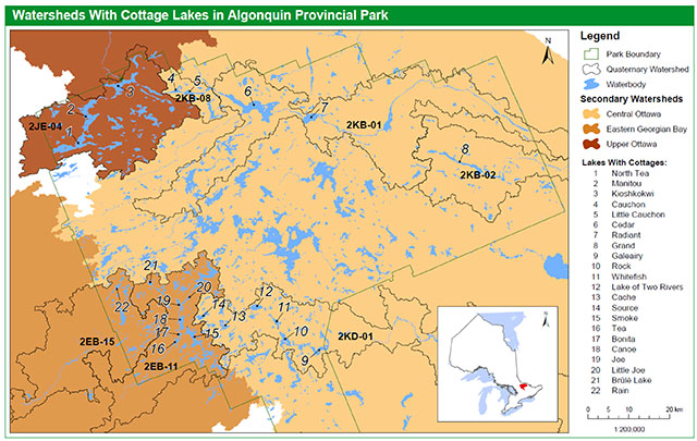
Enlarge figure 1. Watersheds with cottage lakes in Algonquin Provincial Park (PDF)
| Watershed | Lake Name | Lake Area (ha) | Shoreline Perimeter (km) | Max. Depth (m)* | Mean Depth (m)* |
|---|---|---|---|---|---|
| 2EB-11 | Bonita | 56.0 | 5.7 | 3.6 | 3 |
| 2EB-11 | Brûlé | 86.0 | 6.8 | 27 | 11.5 |
| 2EB-11 | Canoe | 359.0 | 29.7 | 41* | 12.1* |
| 2EB-11 | Joe | 138.0 | 16.5 | 24.4 | 6.1 |
| 2EB-11 | Little Joe | 49.7 | 5.4 | 10.3 | 3 |
| 2EB-11 | Smoke | 663.2 | 38.0 | 56.5* | 16.0* |
| 2EB-11 | Tea | 150.3 | 13.7 | 14.5* | 6.6* |
| 2EB-15 | Rain | 166.3 | 18.4 | 23.5 | 5.5 |
| 2JE-04 | Kioshkokwi | 1,100.4 | 45.8 | 45.8 | 12.5 |
| 2JE-04 | Manitou | 1,386.5 | 48.4 | 33.6 | 12.2 |
| 2JE-04 | North Tea | 1,476.4 | 52.9 | 31.1 | 10 |
| 2KB-01 | Cedar | 2,548.6 | 74.7 | 24.9 | 14.1 |
| 2KB-01 | Radiant | 637.7 | 16.2 | 36.9 | 7.7 |
| 2KB-02 | Grand | 735.2 | 39.3 | 16.6 | 8.5 |
| 2KB-08 | Cauchon | 236.7 | 19.6 | 39.2 | 12.4 |
| 2KB-08 | Little Cauchon | 254.0 | 16.3 | 31.5 | 13.7 |
| 2KD-01 | Cache | 286.0 | 26.8 | 34.1 | 6.7 |
| 2KD-01 | Galeairy | 843.0 | 64.9 | 22.9 | 6.1 |
| 2KD-01 | Lake of Two Rivers | 312.0 | 11.3 | 41.5 | 14.5 |
| 2KD-01 | Rock | 511.2 | 33.1 | 34.7 | 7.9 |
| 2KD-01 | Source | 267.8 | 16.2 | 41,5* | 9.4* |
| 2KD-01 | Whitefish | 220.0 | 12.8 | 24.4 | 6.2 |
(Sources of data: Aquatic Resource Area Summary, Land Information Ontario, OMNR;
*Aquatic Science Unit, Science and Information Branch, OMNR)
3.3 Shoreline developments
There is a total of 303 cottage lots in the park (Table 3). Thirteen of the lakes with cottages are within two quaternary sub-watersheds (2EB-11 and 2KD-01) along the Hwy. 60 corridor. These lakes account for 90% of the cottage lots. The remaining lakes are located in five sub-watersheds in less accessible areas of the park. Most of the lots (66%) are concentrated on three lakes: Smoke, Canoe and Cache. Source and Rock Lakes have intermediate levels of cottage development, with 15 and 24 cottage lots, respectively. The remaining lakes have ten or fewer cottage lots. All of the lakes, except Galeairy Lake, are entirely within the park. Galeairy Lake has one cottage lot within the park but several other permanent, seasonal and commercial shoreline developments in the neighbouring municipality.
The average area of cottage lots is 0.43 ha with a mean shoreline frontage of 88 m (Tables 4 and 5). Cottage lots occupy a total of 131 ha of park land and 26 km of shoreline. Access to cottages is primarily by boat. About 82% of cottages are reachable by boat and 18% by road (Table 6).
Commercial leases, campgrounds and designated interior campsites are present on some of the cottage lakes (Table 3). There are seven commercial operations on six lakes. Commercial lodges or youth camps are located on Canoe, Little Joe and Tea Lakes in sub-watershed 2EB-11 and on Cache Lake (two operations), Lake of Two Rivers and Source Lake in sub-watershed 2KD-01. Seven lakes have campgrounds: Tea Lake (2EB-11); Kioshkokwi Lake (2JE-04); Cedar Lake (2KB-01); Grand Lake (2KB-02), and; Lake of Two Rivers, Rock Lake and Whitefish Lake (2KD-01). There are a total of 295 designated interior campsites within 150 m of the shores of 15 of the lakes (Table 3).
Commercial leases (consisting of lodges and youth camps) occupy a total of 56 ha and 9.5 km of shoreline. The total area and frontage of all campgrounds is 94 ha and 6.7 km, respectively (Tables 4 and 5). Two commercial establishments are accessed by boat and road, two are road access only, and three are boat access only. All campgrounds are accessible by road (Table 6).
There are a few other developments on some of the lakes that support park services or operations. The Portage Store on Canoe Lake is a large commercial establishment with a park store, restaurant, staff houses, water treatment plant and sewage facility. Other developments include: an airbase on Smoke Lake (hangar, docks, staff accommodation); a rental Ranger cabin on Rain Lake; a rental Ranger cabin and permit office on Kioshkokwi Lake; the Brent Store, CN leased cottages and two rental Ranger cabins on Cedar Lake; a staff residence on Cache Lake; East Beach Picnic Pavilion and day use area on Lake of Two Rivers, and; a permit office on Rock Lake.
| Watershed | Lake Name | No. of Cottage Lots | No. of Commercial Establishments (# lots) | No. of Campgrounds | No. of Designated Interior Campsites |
|---|---|---|---|---|---|
| 2EB-11 | Bonita | 1 | - | - | - |
| 2EB-11 | Brûlé | 2 | - | - | 3 |
| 2EB-11 | Canoe | 48 | 1 (11) | - | - |
| 2EB-11 | Joe | 6 | - | - | 19 |
| 2EB-11 | Little Joe | 1 | 1 (1) | - | 1 |
| 2EB-11 | Smoke | 89 | - | - | - |
| 2EB-11 | Tea | 10 | 1 (3) | 1 | - |
| 2EB-11 Total | N/A | 157 | 3 (18) | 1 | 23 |
| 2EB-15 | Rain | 1 | - | - | 14 |
| 2EB-15 Total | N/A | 1 | - | - | 14 |
| 2JE-04 | Kioshkokwi | 3 | - | 1 | 24 |
| 2JE-04 | Manitou | 2 | - | - | 46 |
| 2JE-04 | North Tea Lake | 1 | - | - | 71 |
| 2JE-04 Total | N/A | 6 | - | 1 | 141 |
| 2KB-01 | Cedar | 10 | - | 1 | 25 |
| 2KB-01 | Radiant | 4 | - | - | 9 |
| 2KB-01 Total | N/A | 14 | - | 1 | 34 |
| 2KB-02 | Grand | 2 | - | 1 | 21 |
| 2KB-02 Total | N/A | 2 | - | 1 | 21 |
| 2KB-08 | Cauchon | 1 | - | - | 13 |
| 2KB-08 | Little Cauchon | 5 | - | - | 6 |
| 2KB-08 Total | N/A | 6 | - | - | 19 |
| 2KD-01 | Cache | 62 | 2 (3) | - | - |
| 2KD-01 | Galeairy | 1 | - | - | 22 |
| 2KD-01 | Lake of Two Rivers | 6 | 1 (2) | 1 | - |
| 2KD-01 | Rock | 24 | - | 1 | 18 |
| 2KD-01 | Source | 15 | 1 (1) | - | - |
| 2KD-01 | Whitefish | 9 | - | 1 | 3 |
| 2KD-01 Total | N/A | 117 | 4 (11) | 3 | 43 |
| Grand Total | N/A | 303 | 7 | 7 | 295 |
| Watershed | Lake Name | Cottages | Commercial | Campgrounds** | Total |
|---|---|---|---|---|---|
| 2EB-11 | Bonita | 0.4 | - | - | 0.4 |
| 2EB-11 | Brûlé | 1.7 | - | - | 1.7 |
| 2EB-11 | Canoe | 21.1 | 20.5 | - | 41.5 |
| 2EB-11 | Joe | 2.5 | - | - | 2.5 |
| 2EB-11 | Little Joe | 1.1 | 8.5 | - | 9.6 |
| 2EB-11 | Smoke | 36.1 | N/A | - | 36.5 |
| 2EB-11 | Tea | 5.7 | 10.2 | 6.3 | 22.2 |
| 2EB-11 Total | N/A | 68.6 | 39.6 | 6.3 | 114.4 |
| 2EB-15 | Rain | 0.3 | - | - | 0.3 |
| 2EB-15 Total | N/A | 0.3 | - | - | 0.3 |
| 2JE-04 | Kioshkokwi | 1.5 | - | 3.5 | 5.0 |
| 2JE-04 | Manitou | 1.3 | - | - | 1.3 |
| 2JE-04 | North Tea | 0.4 | - | - | 0.4 |
| 2JE-04 Total | N/A | 3.1 | - | 3.5 | 6.6 |
| 2KB-01 | Cedar | 2.1 | - | 31.7 | 33.8 |
| 2KB-01 | Radiant | 3.9 | - | - | 3.9 |
| 2KB-01 Total | N/A | 6.0 | - | 31.7 | 37.7 |
| 2KB-02 | Grand | 1.5 | - | 10.1 | 11.6 |
| 2KB-02 Total | N/A | 1.5 | - | 10.1 | 11.6 |
| 2KB-08 | Cauchon | 0.5 | - | - | 0.5 |
| 2KB-08 | Little Cauchon | 2.8 | - | - | 2.8 |
| 2KB-08 Total | N/A | 3.4 | - | - | 3.4 |
| 2KD-01 | Cache | 24.0 | 4.9 | - | 28.9 |
| 2KD-01 | Galeairy | 0.2 | - | - | 0.2 |
| 2KD-01 | Lake of Two Rivers | 2.6 | 4.8 | 21.9 | 29.3 |
| 2KD-01 | Rock | 10.8 | - | 6.6 | 17.4 |
| 2KD-01 | Source | 6.8 | 6.9 | - | 13.7 |
| 2KD-01 | Whitefish | 4.0 | - | 13.5 | 17.5 |
| 2KD-01 Total | N/A | 48.5 | 16.6 | 42.0 | 107.0 |
|
Grand Total |
N/A | 131.3 | 56.1 | 93.6 | 281.0 |
**Measurements of some campgrounds are approximate and require confirmation.
| Watershed | Lake Name | Cottages | Commercial | Campgrounds** | Total |
|---|---|---|---|---|---|
| 2EB-11 | Bonita | 122.0 | - | - | 122.0 |
| 2EB-11 | Brûlé | 320.0 | - | - | 320.0 |
| 2EB-11 | Canoe | 4,102.0 | 4,122.7 | - | 8,224.7 |
| 2EB-11 | Joe | 556.0 | - | - | 556.0 |
| 2EB-11 | Little Joe | 290.0 | 663.2 | - | 953.2 |
| 2EB-11 | Smoke | 5,893.0 | - | - | 5,893.0 |
| 2EB-11 | Tea | 1,108.0 | 1,179.7 | 535.1 | 2,822.8 |
| 2EB-11 Total | N/A | 12,391.0 | 5,965.6 | 535.1 | 18,891.7 |
| 2EB-15 | Rain | 173.0 | - | - | 173.0 |
| 2EB-15 Total | N/A | 173.0 | - | - | 173.0 |
| 2JE-04 | Kioshkokwi | 257.0 | - | 534.9 | 791.9 |
| 2JE-04 | Manitou | 181.0 | - | - | 181.0 |
| 2JE-04 | North Tea | 131.0 | - | - | 131.0 |
| 2JE-04 Total | N/A | 569.0 | - | 534.9 | 1,103.9 |
| 2KB-01 | Cedar | 735.0 | - | 2,526.9 | 3,261.9 |
| 2KB-01 | Radiant | 517.0 | - | - | 517.0 |
| 2KB-01 Total | N/A | 1,252.0 | - | 2,526.9 | 3,778.9 |
| 2KB-02 | Grand | 404.0 | - | 1,227.2 | 1,631.2 |
| 2KB-02 Total | N/A | 404.0 | - | 1,227.2 | 1,631.2 |
| 2KB-08 | Cauchon | 171.0 | - | - | 171.0 |
| 2KB-08 | Little Cauchon | 435.0 | - | - | 435.0 |
| 2KB-08 Total | N/A | 606.0 | - | - | 606.0 |
| 2KD-01 | Cache | 6,656.0 | 1,166.9 | - | 7,822.9 |
| 2KD-01 | Galeairy | 96.0 | - | - | 96.0 |
| 2KD-01 | Lake of Two Rivers | 391.0 | 1,127.2 | 374.6 | 1,892.8 |
| 2KD-01 | Rock | 1,761.0 | - | 689.3 | 2,450.3 |
| 2KD-01 | Source | 1,628.0 | 1,210.7 | - | 2,838.7 |
| 2KD-01 | Whitefish | 449.0 | - | 771.4 | 1,220.4 |
| 2KD-01 Total | N/A |
10,981.0 |
3,504.8 |
1,835.3 |
16,321.1 |
| Grand Total | N/A | 26,376.0 | >9,470.4 | 6,659.4 | 42,505.8 |
**Measurements of some campgrounds are approximate and require confirmation.
| Watershed | Lake Name | Boat (Cottages) | Road (Cottages) | Boat (Commercial) | Road (Commercial) | Boat (Campgrounds) | Road (Campgrounds) |
|---|---|---|---|---|---|---|---|
| 2EB-11 | Bonita | 1 | - | - | - | - | - |
| 2EB-11 | Brûlé | 2 | - | - | - | - | - |
| 2EB-11 | Canoe | 39 | 9 | 1 | 1 | N/A | N/A |
| 2EB-11 | Joe | 6 | - | - | - | - | - |
| 2EB-11 | Little Joe | 1 | - | N/A | 1 | N/A | N/A |
| 2EB-11 | Smoke | 86 | 3 | - | - | - | - |
| 2EB-11 | Tea | 4 | 6 | 1 | 1 | N/A | 1 |
| 2EB-11 Total | N/A | 139 | 18 | 2 | 3 | - | 1 |
| 2EB-15 | Rain | 1 | - | - | - | - | - |
| 2EB-15 Total | N/A | 1 | - | - | - | - | - |
| 2JE-04 | Kioshkokwi | 3 | - | N/A | N/A | N/A | 1 |
| 2JE-04 | Manitou | 2 | - | - | - | - | - |
| 2JE-04 | North Tea Lake | - | 1 | - | - | - | - |
| 2JE-04 Total | N/A | 5 | 1 | - | - | - | 1 |
| 2KB-01 | Cedar | 1 | 9 | - | - | - | 1 |
| N/A | Radiant | 3 | 1 | - | - | - | - |
| 2KB-01 Total | N/A | 4 | 10 | - | - | - | N/A |
| 2KB-02 | Grand | 1 | 1 | - | - | - | 1 |
| 2KB-02 Total | N/A | 1 | 1 | - | - | - | 1 |
| 2KB-08 | Cauchon | - | 1 | - | - | - | - |
| N/A | Little Cauchon | 1 | 4 | - | - | - | - |
| 2KB-08 Total | N/A | 1 | 5 | - | - | - | - |
| 2KD-01 | Cache | 62 | - | 2 | - | - | - |
| N/A | Galeairy | 1 | - | - | - | - | - |
| N/A | Lake of Two Rivers | 1 | 5 | - | 1 | - | 1 |
| N/A | Rock | 17 | 7 | - | - | - | 1 |
| N/A | Source | 15 | - | 1 | - | - | N/A |
| N/A | Whitefish | 1 | 8 | - | - | - | 1 |
| 2KD-01 Total | N/A | 97 | 20 | 3 | 1 | - | 3 |
|
Grand Total |
N/A |
248 |
55 |
5 |
4 |
0 |
6 |
4.0 Values
Natural and cultural heritage features or processes that are important enough to warrant special attention are often referred to as ’values’. The following ecological values are a subset of the overall values within Algonquin Provincial Park, and are limited to those that would be expected to be impacted by cottages.
4.1 Water quality
Algonquin has nearly 2,500 lakes and encompasses the headwaters of several major river systems (OMNR 1998). Clean water is essential to support aquatic species and ecosystems of the park and the many water-based recreational activities that are enjoyed by visitors. Because several waterways originate in the park, the water quality of the lakes in the park is also important for downstream ecosystems and communities outside its boundary. Water quality can be degraded by the input of excessive nutrients from shoreline developments. Based on available data, two measures of water quality are described for the cottage lakes: total phosphorus and dissolved oxygen.
4.1.1 Total phosphorus
Total phosphorus is a nutrient that most commonly limits the growth of algae and plants in lakes within the Precambrian Shield. Oligotrophic lakes, such as those that are typical of Algonquin Provincial Park, are characterized by low nutrient levels, low primary productivity (e.g., growth of algae and aquatic plants) and well oxygenated waters. The clear, cold waters of oligotrophic lakes are valued for their aesthetic appeal, recreational opportunities and coldwater fisheries.
Total phosphorus concentrations in oligotrophic lakes are generally less than10 µg/L, although natural background levels vary among lakes (MOE et al. 2010). The Ministry of Environment’s (MOE) provincial water quality objective for total phosphorus allows for a 50% increase above a modeled natural baseline in the absence of human influence (MOE et al. 2010). Lakes with total phosphorus concentrations that exceed this level are considered to be at capacity for shoreline development, and at risk of water quality and ecosystem impairment.
Average total phosphorus was calculated for 14 of the lakes that had at least one year of sampling during spring turnover. Total phosphorus was less than 10 µg/L in 12 of these lakes. This threshold was exceeded in Brûlé and Whitefish Lakes. The levels in these lakes may be due to naturally higher levels of phosphorus or may be an indication of water quality impairment. Natural baseline levels were not modelled for this report. Consequently, a comparison of total phosphorus levels with the provincial water quality objective is not possible at this time. In addition, since phosphorus concentrations can vary from year to year, at least two years of spring sampling data is recommended.
Natural baseline levels were modelled for Cache Lake by Gartner Lee Limited in 2007 in response to concerns by cottagers over algal blooms on the lake. Based on these model results, cottages on this lake were estimated to contribute about 30% of the total phosphorus inputs (Gartner Lee Limited 2007).
| Watershed | Lake | Years of Spring TP Sampling | No. of TP Samples | Avg. Measured TP (µg/L) |
|---|---|---|---|---|
| 2EB-11 | Bonita | no data | N/A | N/A |
| 2EB-11 | Brûlé | 2012 | 1 | 11.4 |
| 2EB-11 | Canoe | no data | N/A | N/A |
| 2EB-11 | Joe | 2006 | 1 | 3.2 |
| 2EB-11 | Little Joe | no data | N/A | N/A |
| 2EB-11 | Smoke | 1982-1985, 2002, 2003 | 7 | 6.64 |
| 2EB-11 | Tea | no data | N/A | N/A |
| 2EB-15 | Rain | no data | N/A | N/A |
| 2JE-04 | Kioshkokwi | no data | N/A | N/A |
| 2JE-04 | Manitou | 2012 | 2 | 7.25 |
| 2JE-04 | North Tea Lake | no data | N/A | N/A |
| 2KB-01 | Cedar | 2003 | 1 | 7.25 |
| 2KB-01 | Radiant | no data | N/A | N/A |
| 2KB-02 | Grand | 2003 | 1 | 9.4 |
| 2KB-08 | Cauchon | 2003 | 1 | 5.4 |
| 2KB-08 | Little Cauchon | 2003 | 1 | 5.7 |
| 2KD-01 | Cache | 2002, 2003, 2006, 2012 | 5 | 7.87 |
| 2KD-01 | Galeairy | 2002 | 1 | 6.0 |
| 2KD-01 | Lake of Two Rivers | 2002, 2003 | 2 | 7.15 |
| 2KD-01 | Rock | 2002 | 1 | 7.6 |
| 2KD-01 | Source | 2012 | 1 | 3.7 |
| 2KD-01 | Whitefish | 2002, 2006, 2010 | 5 | 11.6 |
(Sources of data: Wilton and Banks 2004, MOE)
4.1.2 Dissolved oxygen
Dissolved oxygen is a critical determinant of habitat for coldwater fish species, such as brook trout (Salvelinus fontinalis) and lake trout (Salvelinus namaycush). Both species require cold, well oxygenated water to support their life processes (Evans 2007, OMNR 2007). Dissolved oxygen can be especially limiting in late summer when warm water at the lake surface causes these species to retreat to cooler temperatures at deeper depths (Strickland 1995, Evans 2007).
Beginning in the spring, the deep oligotrophic lakes of Algonquin Provincial Park stratify as warming of surface water creates a difference in density with colder, deeper water. The bottom cold layer of a stratified lake is called the hypolimnion. Since the waters of the hypolimnion do not mix with oxygenated surface waters during the summer, oxygen levels decline as algae and other organisms drift to the bottom and decompose.
MNR has established a Mean Volume Weighted Hypolimnetic Dissolved Oxygen (MVWHDO) criterion of 7 mg/L for the protection of lake trout habitat in inland lakes on the Precambrian Shield (MOE et al. 2010). This criterion is based on the late summer hypolimnetic dissolved oxygen level needed to support most of the life processes of juvenile lake trout without detrimental effects on growth or recruitment (Evans 2007). The criterion is used to determine the development capacity of lakes designated by policy to be managed for lake trout. Lakes are considered to be at capacity if the MVWHDO is at or below 7 mg/L for at least three years during the sampling period of August 15 to September 15 (Dunlop et al. 2009).
Lake bathymetry and sufficient dissolved oxygen data were available to calculate the MVWHDO for six of the cottage lakes. Regression analysis was performed to correct MVWHDO to a standard date of September 15, using a minimum of three dissolved oxygen profiles taken during the open water season for each year that data were available. MVWHDO at September 15 was at or below 7 mg/L in five of the lakes (Table 8). These included Canoe and Smoke Lakes in sub-watershed 2EB-11 and Cache Lake, Galeairy Lake and Source Lake in sub- watershed 2KD-01.
A minimum of three years of data over a ten year period is necessary to determine if a lake is “at capacity” for development based on the dissolved oxygen criterion. Based on this criterion, Cache Lake is “at capacity”. Galeairy Lake was previously identified by MOE as “at capacity”.
| Watershed | Lake Name | Years of Dissolved Oxygen Sampling | Avgerage MVWHDO at Sep 15 |
|---|---|---|---|
| 2EB-11 | Canoe | 2001 | 5.4 |
| 2EB-11 | Smoke | 2001, 2003 | 6.8 |
| 2KD-01 | Cache | 2001, 2002, 2003 | 4.2 |
| 2KD-01 | Galeairy | 1995, 2006, 2010 | 2.6 |
| 2KD-01 | Lake of Two Rivers | 2002, 2003 | 8.6 |
| 2KD-01 | Source | 2001 | 5.3 |
(Sources of data: Wilton and Banks 2004; MOE; Algonquin Fisheries Assessment Unit, Science and Information Branch, OMNR; Aquatic Science Unit, Science and Information Branch, OMNR).
4.1.3 Effects of watershed position on water quality
In the absence of water quality data for several of the cottage lakes, the size and position of the lakes in their respective watersheds can be useful in assessing their resilience to land use activities, as well as their contribution to downstream conditions. In general, lakes located in upper portions of watersheds tend to be smaller and shallower than those in downstream positions (Quinlan et al. 2003). These lakes are more likely to have lower oxygen levels in late summer than larger, deeper lakes located lower in the watershed (Quinlan et al. 2003).
Because lake trout habitats may already be marginal under these conditions, any impacts from shoreline developments can be significant (Evans et al. 1991). Effects of development on water quality of lakes in mid to lower watershed positions can be buffered by up-gradient flows; however, water quality in these lakes can be degraded if there is significant development upstream.
Seven of the cottage lakes are in upper watershed positions (Table 9). Among these lakes, Cache and Source are the most intensively developed. The position of these lakes and the number of developments on them would potentially make them more vulnerable to water quality degradation. Since Cache and Source Lakes are at the top of the same watershed (2KD-01), they would be expected to influence water quality in downstream lakes, including Lake of Two Rivers, Whitefish, Rock and Galeairy Lakes. The other lakes in upper watershed positions have few developments.
| Quaternary Watershed | Lake | Watershed Position |
|---|---|---|
| 2EB-11 | Bonita | Middle |
| 2EB-11 | Brûlé | Upper |
| 2EB-11 | Canoe | Upper to Middle |
| 2EB-11 | Joe | Upper to Middle |
| 2EB-11 | Little Joe | Upper to Middle |
| 2EB-11 | Smoke | Upper to Middle |
| 2EB-11 | Tea | Middle |
| 2EB-15 | Rain | Upper |
| 2JE-04 | Kioshkokwi | Lower |
| 2JE-04 | Manitou | Upper to Middle |
| 2JE-04 | North Tea | Upper to Middle |
| 2KB-01 | Cedar | Upper to Middle |
| 2KB-01 | Radiant | Upper to Middle |
| 2KB-02 | Grand | Upper |
| 2KB-08 | Cauchon | Upper |
| 2KB-08 | Little Cauchon | Upper |
| 2KD-01 | Cache | Upper |
| 2KD-01 | Galeairy | Lower |
| 2KD-01 | Lake of Two Rivers | Upper to Middle |
| 2KD-01 | Rock | Middle |
| 2KD-01 | Source | Upper |
| 2KD-01 | Whitefish | Upper to Middle |
Thirteen of the lakes are in upper to middle or middle watershed positions and two are in lower portions of their sub-watersheds. In sub-watershed 2EB-11, some lakes in upper to middle and middle positions are at greater risk of water quality degradation than others. Tea Lake receives direct flow from Canoe Lake and Smoke Lake, both of which have significant cottage activity. This situation is of concern since Tea Lake is a comparatively small lake with limited inflow outside of the main system of Smoke, Canoe, Joe and Little Joe Lakes. Similarly, Bonita Lake may be at risk due to its small size and its location directly downstream from Canoe Lake; however, this lake has only one cottage on its shores. The other lakes in this system receive significant flow from large, undeveloped lakes upstream, which would help to dilute excess nutrients coming from developed lakes.
4.2 Headwater protection
Algonquin Provincial Park provides a critical function in the protection of significant headwaters, which was one of the purposes for its establishment in 1893 (OMNR 1998). Because of the topographic effect of the “Algonquin dome”, a total of four major (secondary) watersheds emanate from the park. The secondary watersheds are comprised of tertiary watersheds which in turn are made up of quaternary watersheds.
The park is a unique headwater area. In the northwest region of the park, near Gibson Lake, there is a surface water divisional node or point that separates three major secondary watersheds: The Central Ottawa, The Upper Ottawa, and The Wanapitei and French. In addition, the Eastern Georgian Bay secondary watershed flows out of the southwest corner of the park. There are a total of 37 quaternary watersheds that are at least partially within the footprint of the park.
The headwater regions of a watershed provide many important hydrologic and biological functions with impacts felt through the rest of the watercourse. It is the source of many springs, seeps and ephemeral creeks that ultimately flow down- gradient to produce a network of streams and lakes. Headwaters supply downstream reaches with essential nutrients and clean, cool, well-oxygenated water. Protection of headwaters is vitally important to preserving the quality and flow of water in the remainder of the watershed.
Cottage lakes in Algonquin occupy three of the four secondary watersheds in the park and seven quaternary watersheds (Table 1).
4.3 Fish and critical fish habitats
Algonquin is well known for its trout fishery and coldwater fish communities. Fishing is one of the most popular activities in the park. In 2011, 39% and 26% of backcountry and campground visitors, respectively, reported that they fished during their time in the park (Ipsos Reid 2012a and 2012b). Cottage developments can affect many of the components of aquatic ecosystems that fish and other species rely on, such as water quality, groundwater recharge and discharge areas, and riparian and nearshore habitats.
4.3.1 Lake trout
Lake trout are a highly sought sport fish as well as a significant component of Ontario’s biodiversity. Lake trout have a relatively limited distribution provincially and globally due to their adaptation to the cold oligotrophic lakes that formed with the retreat of the glaciers. About 1% of the lakes in the province contain lake trout, which represents 20 to 25% of the lake trout lakes in the world (OMNR 2006).
Algonquin has a unique glacial past, which resulted in isolation of coldwater habitats before warm water species could colonize (Mandrak and Crossman 2003). As a result, Algonquin has one of the highest densities of lake trout lakes in the province or the world (Mandrak and Crossman 2003). The park is well known for some of the best recreational fishing in the province, in large part due to the availability and quality of its lake trout fishery (Strickland 1995, OMNR 1998).
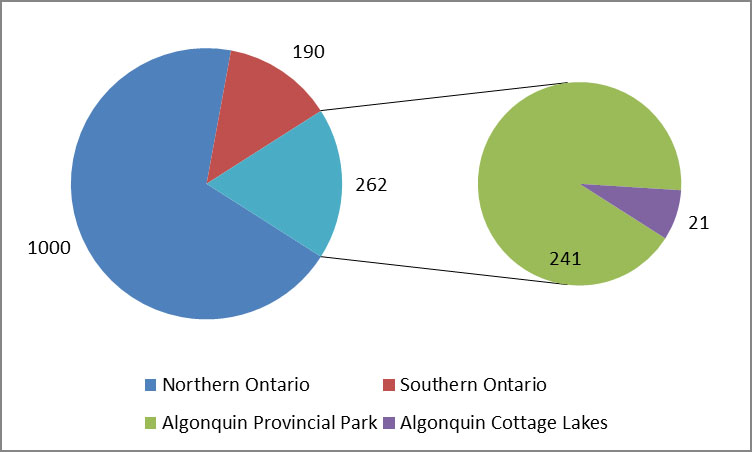
Seven percent of the designated natural lake trout lakes in the province, and 40% of those in southern Ontario, are in Algonquin Provincial Park (Figure 1) (OMNR 2006). Designated “natural” lake trout lakes are those that are managed for naturally reproducing populations, including ones identified for restoration of extirpated populations. OMNR policies and guidelines apply to these designated lakes to protect them from the effects of development and other pressures (OMNR 2005, 2006 and 2008).
All of the cottage lakes, except Bonita Lake, have been designated as natural lake trout lakes (OMNR 2006). This represents about 14.2% of Algonquin’s lake trout lakes.
4.3.2 Brook trout
Brook trout is another prized sport fish species that is uniquely adapted to Algonquin’s coldwater lakes. Brook trout are second only to lake trout in their importance to the sport fishery in the park (Strickland 1995).
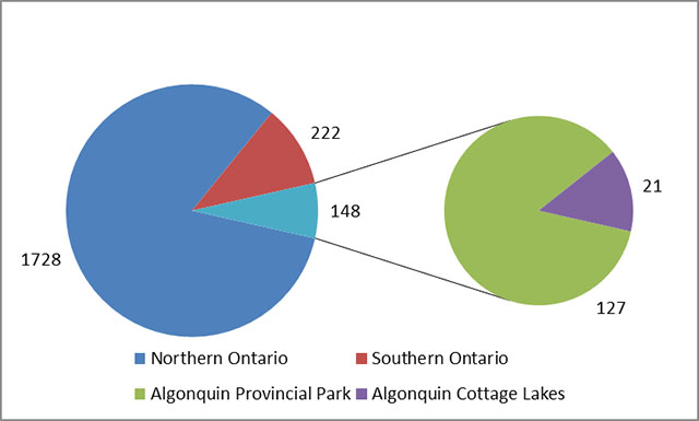
Algonquin has the highest global concentration of brook trout lakes (Mandrak and Crossman 2003). Brook trout lakes in other parts of its range are in decline. In the eastern U.S., only 31% of sub-watersheds within the native range of stream- dwelling brook trout are classified as having self-sustaining populations; populations are known or predicted to be extirpated in 28% of sub-watersheds (Hudy et al. 2008). Within Ontario, Algonquin accounts for 18% of the brook trout lakes in the province and 58% of those in southern Ontario (OMNR 2007) (Figure 2).
All of the cottage lakes in the park, except Bonita, have records of brook trout (Crossman and Mandrak 1992). This represents about 8% of Algonquin’s native brook trout lakes (Figure 2).
4.3.3 Other fish species
Algonquin has many unique fish species and communities due to its glacial history. Notably, blackfin cisco (Coregonus nigripinnis), a fish species thought to be extinct, was discovered in Radiant Lake in 2010. Since then, it has also been found in Cedar Lake. Blackfin cisco inhabits deep waters of coldwater lakes. Opossum shrimp (Mysis relicta), another glacial relict species, is known to be present in Grand and Radiant Lakes and is the primary food of blackfin cisco in Radiant Lake.
4.3.4 Critical fish habitats
Critical fish habitats are areas on which fish depend for one or more life stages, including spawning, nursery and feeding areas, movement corridors and migration routes, and the ecological processes that maintain them. Although Algonquin has a diversity of fish species and communities, only the habitats of lake trout and brook trout are highlighted due to their relatively narrow and specialized requirements, the significance of these species provincially and globally, and their importance to the recreational fishery.
Lake trout require cold, well-oxygenated waters that are less than 100C and that have greater than 7 mg/L dissolved oxygen (Scott and Crossman 1973). They spawn in the fall over rocky shorelines or deep-water shoals. Eggs filter into crevices formed by the substrate where they remain for four to five months before hatching in February or March (Scott and Crossman 1973). Fry may spend up to a month in shallow waters nearshore before dispersing to deeper habitats (Scott and Crossman 1973). Maintenance of water levels during spawning and incubation periods is critical to provide access for egg-laying and to prevent eggs from being dewatered before hatching (Evans 1991). Lake trout spend the summer in colder, deeper waters of the hypolimnion where dissolved oxygen levels are a critical determinant of habitat in the late summer.
Spawning habitat has been mapped on Smoke Lake, where some sites are in the vicinity of cottage lots. Spawning habitats have not been mapped on the other cottage lakes; however, suitable habitat is most likely to be found on rocky shorelines with steep slopes that are exposed to west and southwest prevailing winds (MacLean et al. 1990, Flavelle et al. 2002). Information on slope, depth and fetch has been used to predict the location of spawning habitats in other lakes in the park (Flavelle et al. 2002). Late summer hypolimnetic dissolved oxygen levels of cottage lakes have been described in Section 4.1.2.
Brook trout have higher temperature and oxygen tolerances than lake trout, requiring temperatures less than 20°C and greater than 5 mg/L dissolved oxygen (Scott and Crossman 1973). Brook trout spawn in the fall in gravel substrates over groundwater upwellings along the shores of lakes or in streams. Eggs incubate in the substrate until they hatch in fifty to a hundred days. Fry stay in the substrate until they are free-swimming (Scott and Crossman 1973). Shallow water areas of lakes and streams are used in the spring and early summer and cooler deep-water areas in the summer (Borwick et al. 2006). Areas of groundwater discharge are a critical feature of spawning habitat and young of the year nursery habitat (Quinn 1995, Borwick et al. 2006). Groundwater provides oxygen-rich water and coldwater refugia during the summer (Quinn 1995, Curry and Devito 1996, Banks 2009). These habitat conditions are relatively rare in lakes, occurring along only 0.5 to 7.9% of the shores of twenty-one study lakes in Algonquin (Borwick et al. 2006, Hicks 2009). Recharge areas located in uplands adjacent to shore must be maintained to sustain discharge areas in lakes (Curry and Devito 1996, Hicks 2009).
Brook trout spawning and nursery habitats have not been mapped in the cottage lakes. Furthermore, brook trout that are resident in lakes may have been recruited from nursery streams and not from a lake spawning population (Ridgway 2008). Despite these uncertainties, areas of groundwater recharge and discharge remain critical aquatic habitats due to their rarity and productivity for other species besides brook trout.
Probable groundwater recharge and discharge areas have been mapped in the park based on topographic and other information (Ontario Parks 2007). While this mapping provides a broad indication of groundwater and surface water interactions, ground-truthing at local scales is necessary. Based on the mapping, few cottage lots coincided with significant probable recharge or discharge areas. Cache Lake was the only lake with significant overlap of cottage lots with recharge zones along the west shore. A few cottage lots may coincide with recharge or discharge zones on ten of the cottage lakes, including Canoe, Little Joe, Smoke, Tea, Manitou, North Tea, Cedar, Cauchon, Little Cauchon and Rock Lakes. There was no overlap of cottage lots with recharge or discharge zones on the remaining eleven lakes (Bonita, Brûlé, Joe, Rain, Kioshkokwi, Radiant, Grand, Galeairy, Lake of Two Rivers, Source and Whitefish).
4.4 Riparian and littoral habitats
Riparian and littoral habitats are critical components of lake ecosystems. As the interface between land and water, natural shorelines provide habitats for both terrestrial and aquatic species. Vegetation along shore and in the water performs many functions. Overhanging vegetation shades the water and provides a source of terrestrial insects that is an important food source for many fish (Engels and Pederson 1998, Francis and Schindler 2009). Dead leaves, trees and branches that fall into the water provide places for algae and invertebrates to colonize, supply structure and cover for birds, mammals, reptiles and amphibians, and is an important component of habitat for brook trout and other fish species (Guyette and Cole 1999). Warmer, shallow waters near shore where aquatic plants can grow are some of the most productive and are particularly important in oligotrophic lakes where this type of habitat is limited (Rosenberger et al.2008). In addition, riparian vegetation filters sediments, nutrients and pollutants (Engels and Pederson 1998).
Many species of birds, mammals, reptiles and amphibians are dependent on shoreline habitats for at least part of the year for food, cover and reproduction (Racey and Euler 1982, Engels and Pederson 1998, Elias and Meyer 2003, Woodford and Meyer 2003, Newbrey et al. 2005, Fisheries and Oceans 2008, Henning and Raemsburg 2009). Bird diversity and abundance, for example, are higher in riparian habitats than in adjacent uplands (Henning and Raemsburg 2009). Riparian and littoral areas are also critical for fish and other aquatic species. About 90% of aquatic species spend a portion of their life cycle in the littoral zone, which is used as spawning and nursery habitat and for feeding and cover (Fisheries and Oceans Canada 2008).
Recommendations for the amount of natural shoreline that is necessary to protect lake ecosystems tend to be for individual lots rather than on a whole-lake basis. DFO recommends that less than 25% of riparian habitats, on land and in water, along the frontage of a shoreline property should be altered for developments such as docks and boathouses (Fisheries and Oceans Canada 2007). MOE and MNR recommend maintaining a 30 m wide buffer of natural vegetation along the shorelines of coldwater lakes to protect water quality and fish habitats (MOE et al. 2010). Maintenance of 75% of riparian habitats to protect stream ecosystems has been recommended by Environment Canada in recognition of the importance of terrestrial vegetation to stream habitats (Environment Canada 2004). The significance of riparian habitats to the functioning of lake ecosystems has been less well studied; however, even small changes in the amount of development on lakes has been associated with shifts in fish diet and distribution and the composition, abundance and diversity of small mammals, amphibians, birds, algae and invertebrates (Racey and Euler 1982, Clark et al.1983, Woodford and Meyer 2003, Scheuerell and Schindler 2004, Rosenberger et al. 2008, Francis and Schindler 2009, Henning and Raemsburg 2009, Wehrly et al. 2012).
The amount of developed and natural shorelines on cottage lakes was assessed by calculating the frontage of cottage and commercial lots and campgrounds relative to the shoreline perimeter of each lake, inclusive of islands (Table 10). For this calculation, the entire frontage of leased lots and campgrounds was categorized as developed shoreline due to the potential for natural vegetation to have been altered by human activities anywhere on the lot. The amount of natural, undeveloped shoreline on the cottage lakes ranged from about 71% to over 99% of the lake perimeters. The lowest proportion of undeveloped shoreline was on lakes in the sub-watersheds along the Hwy. 60 corridor, 2EB-11 and 2KD-01. Two of these lakes had less than 75% natural shoreline: Cache Lake, in sub-watershed 2KD-01 (71%) and Canoe Lake in sub-watershed 2EB-11 (72%). The length of natural shoreline was greater than 95% for all lakes in the less accessible sub-watersheds (2EB-15, 2JE-04, 2KB-01, 2KB-02 and 2KB-08).
The amount of shoreline within cottage lots was highest on Cache (25%), Smoke (16%), Canoe (14%) and Source (10%) Lakes. Commercial shoreline frontage was greatest on Canoe Lake, Little Joe Lake, Lake of Two Rivers and Tea Lake (approximately 14%, 12%, 10% and 9% of shoreline perimeter, respectively). Campgrounds accounted for 6% of shoreline frontage on Whitefish Lake and 1% to 4% on Kioshkokwi, Rock, Grand, Lake of Two Rivers, Cedar and Tea Lakes.
| Watershed | Lakes | Cottage Lot (%) | Commercial Lease (%) | Campground (%) | Undeveloped shoreline (%) |
|---|---|---|---|---|---|
| 2EB-11 | Bonita Lake | 2.1 | - | - | 97.9 |
| 2EB-11 | Brûlé Lake | 4.7 | - | - | 95.3 |
| 2EB-11 | Canoe Lake | 13.8 | 13.9 | - | 72.3 |
| 2EB-11 | Joe Lake | 3.4 | - | - | 96.6 |
| 2EB-11 | Little Joe Lake | 5.4 | 12.3 | - | 82.3 |
| 2EB-11 | Smoke Lake | 15.5 | - | - | 84.5 |
| 2EB-11 | Tea Lake | 8.1 | 8.6 | 3.9 | 79.4 |
| 2EB-15 | Rain Lake | 0.9 | - | - | 99.1 |
| 2JE-04 | Kioshkokwi Lake | 0.6 | - | 1.2 | 98.3 |
| 2JE-04 | Manitou Lake | 0.4 | - | - | 99.6 |
| 2JE-04 | North Tea Lake | 0.2 | - | - | 99.8 |
| 2KB-01 | Cedar Lake | 1.0 | - | 3.4 | 95.6 |
| 2KB-01 | Radiant Lake | 3.2 | - | - | 96.8 |
| 2KB-02 | Grand Lake | 1.0 | - | 3.1 | 95.9 |
| 2KB-08 | Cauchon Lake | 0.9 | - | - | 99.1 |
| 2KB-08 | Little Cauchon Lake | 2.7 | - | - | 97.3 |
| 2KD-01 | Cache Lake | 24.9 | 4.4 | - | 70.8 |
| 2KD-01 | Galeairy Lake | 0.1 | - | - | 99.9 |
| 2KD-01 | Lake of Two Rivers | 3.5 | 10.0 | 3.3 | 83.2 |
| 2KD-01 | Rock Lake | 5.3 | - | 2.1 | 92.6 |
| 2KD-01 | Source Lake | 10.0 | 7.5 | - | 82.5 |
| 2KD-01 | Whitefish Lake | 3.5 | - | 6.0 | 90.4 |
4.5 Significant natural areas
One of the purposes of the Provincial Parks and Conservation Reserves Act is to protect representative examples of all of Ontario’s ecosystems. MNR uses the combination of landform and vegetation associations (LV types) within each of the 71 ecodistricts in Ontario as the basis for assessing representation of ecosystems in protected areas. Ecodistricts are ecological land units with broad similarities in land formations and predominant vegetation (Davis and McCalden 2004). The landform-vegetation types that are present in protected areas are compared against minimum thresholds to protect the greater of at least 1% or 50 ha of each LV type in each ecodistrict. Critical LV types are those that are under- represented in protected areas or that would become under-represented if the individual park or conservation reserve was no longer protected (Davis 2006).
Algonquin Provincial Park is situated in two ecodistricts. The west side of the park is in Ecodistrict 5E-9 and the east side is in 5E-10. A description of these ecodistricts in the park is provided in the Algonquin Provincial Park Management Plan (OMNR 1998). All of the cottage lakes except those in sub-watersheds 2KB-01 and 2KB-02 are within Ecodistrict 5E-9. Radiant and Grand Lakes in these sub-watersheds are in Ecodistrict 5E-10, while Cedar Lake is partially within both ecodistricts.
There are a total of 160 landform-vegetation types in the Ecodistrict 5E-9 portion of the park, of which 145 are considered to be critical. One hundred fifty-eight (158) of the 178 landform-vegetation types in the 5E-10 portion of the park are critical (Table 11).
The cottage lots intersect 39 (24%) of the landform-vegetation types in the park in Ecodistrict 5E-9 (excluding the recreation/utilization zone), 31 of which are classified as critical (Table 11). In Ecodistrict 5E-10, eight (4%) landform- vegetation types coincide with cottage lots, six of which are classified as critical. About 63% of the cottage lots intersect one or more critical landform-vegetation types (Table 12). The most frequently intersected landform-vegetation types are those that are common in the park and the ecodistrict; however, several of the critical landform-vegetation types are rare in the ecodistrict and/or in the protected area system. Two of these critical landform-vegetation types are below minimum thresholds.
Mapping and classification of landform-vegetation types is based on digital Ontario Geological Survey maps of quaternary geology and Forest Resource Inventory maps. Use of this mapping to interpret the overlap of cottage lots with landform-vegetation types is limited by the coarse scale of these data sources. Field verification is necessary to confirm the presence, type and significance of landform and vegetation associations in the vicinity of the cottages.
| Ecodistrict | No. Landform-Vegetation Types (LVs) | Algonquin Provincial Park | Cottage Lots |
|---|---|---|---|
| 5E-9 | Total No. of LVs | 160 | 39 |
| 5E-9 | No. of Critical LVs | 145 | 31 |
| 5E-10 | Total No. of LVs | 178 | 8 |
| 5E-10 | No. of Critical LVs | 158 | 6 |
| Watershed | Lake Name | No. Cottage Lots Intersecting Critical LV types |
|---|---|---|
| 2EB-11 | Bonita | 1 |
| 2EB-11 | Brûlé | 2 |
| 2EB-11 | Canoe | 32 |
| 2EB-11 | Joe | 2 |
| 2EB-11 | Little Joe | 1 |
| 2EB-11 | Smoke | 71 |
| 2EB-11 | Tea | 8 |
| 2EB-15 | Rain | 1 |
| 2JE-04 | Kioshkokwi | 2 |
| 2JE-04 | Manitou | 2 |
| 2JE-04 | North Tea | 1 |
| 2KB-01 | Cedar | 4 |
| 2KB-01 | Radiant | 1 |
| 2KB-02 | Grand | 2 |
| 2KB-08 | Cauchon | 1 |
| 2KB-08 | Little Cauchon | 3 |
| 2KD-01 | Cache | 19 |
| 2KD-01 | Galeairy | - |
| 2KD-01 | Lake of Two Rivers | 3 |
| 2KD-01 | Rock | 16 |
| 2KD-01 | Source | 13 |
| 2KD-01 | Whitefish | 7 |
| Total | N/A | 192 |
5.0 Pressures
The following pressures on Algonquin’s ecological values are directly or indirectly linked to cottages through published litreature and/or analysis.
5.1 Degradation of water quality
Excess nutrients from human activities can detrimentally affect the water quality of inland lakes and aquatic ecosystems. Sources of nutrients from shoreline developments include septic systems, fertilizers, run-off from yards and gardens, and exposed soils (MOE et al. 2010). Nutrient levels can also be affected by clearing of vegetation and shoreline erosion (MOE et al. 2010).
Phosphorus is a limiting nutrient for growth of plants and algae in most lakes on the Precambrian Shield (Steedman et al. 2004). Increases in phosphorus can cause algal blooms and increased plant growth, resulting in impairments to aesthetics, recreational activities and coldwater fish habitat (Steedman et al. 2004, MOE et al. 2010). Shoreline developments that increase phosphorus inputs into a lake can also affect downstream water quality (MOE et al. 2010).
Cottage septic systems are considered to be the primary human source of phosphorus in lakes on the Precambrian Shield, in the absence of agricultural or urban sources (MOE et al. 2010, Evans et al. 1991). Greywater (untreated household wastewater not contaminated by toilet waste) typically accounts for the greatest volume of wastewater and contains significant amounts of nitrogen and phosphorus (World Health Organization 2006). Septic systems in areas with thin soils over bedrock slow the movement of nutrients but do not prevent them from eventually reaching adjacent water bodies (Wilkinson et al. 1999, MOE et al. 2010). Long-term retention of phosphorus has been demonstrated to be as high as 90% in some soil types with a depth greater than 6 m (MOE et al. 2010).
Most of the septic systems of the Algonquin cottages are Class 1 (outhouses) and Class 2 (greywater pit or leaching bed) (Gerrits Drilling and Engineering Ltd. 2011). Septic system inspections were completed for 243 of the cottage lots between 2007 and 2010. Deficiencies that were identified included: greywater discharging to the ground surface or with inadequate cover to prevent runoff from entering and overflowing the system (58 lots); greywater discharging directly to the lake (2 lots), and; outhouses in need of structural repair (15 lots) (Gerrits Drilling and Engineering Ltd. 2011). In addition to these issues, about 47% (114) of the lots that were inspected had greywater systems and 11.5% (28) had outhouses that were less than 15 m from a water body (Gerrits Drilling and Engineering Ltd. 2011). Similar issues were identified in a survey of 31 cottage lots in the park in Nightingale Township in 2009 (Reddering and Rose 2009). A minimum 30 m setback of all buildings and structures is recommended by MOE and MNR to protect fish habitat and water quality of lakes on the Precambrian Shield (MOE et al. 2010). Fifteen meters is the minimum setback required by the Ontario Building Code to prevent pathogens that are harmful to humans from entering the water. This setback, however, does not account for protection of aquatic ecosystems from phosphorus inputs.
Water quality data for several lakes in sub-watersheds 2EB-11 (Brûlé, Canoe, Smoke Lakes) and 2KD-01 (Cache, Galeairy, Lake of Two Rivers, Source, Whitefish Lakes) indicate that they may be sensitive to existing or additional phosphorus inputs from human sources (Section 4.1). Other developments on the cottage lakes, such as resorts, youth camps and campgrounds, also contribute phosphorus to lake ecosystems. The lakeshore capacity assessment model (MOE et al. 2010) is a tool that could assist with quantifying the contributions of phosphorus from these different sources and the amount of development that can be sustained without adverse effects. In particular, those watersheds in the park that are most intensively developed (2EB-11 and 2KD-01) should be assessed.
Since headwater protection is a significant value and purpose of Algonquin Provincial Park, it is critical that pressures that degrade water quality are mitigated to protect a supply of clean water for downstream communities and ecosystems. Headwater protection may be detrimentally affected by the intensity of cottage and other development in quaternary watersheds 2EB-11 and 2KD-01, located in the Eastern Georgian Bay and Central Ottawa secondary watersheds, respectively. These quaternary watersheds within the park contain portions of the headwaters of the Muskoka (2EB-11) and Madawaska (2KD-01) Rivers. Cottage development in the other quaternary watersheds would not be expected to affect headwater protection as there are few lakes with cottages in these sub- watersheds and the number of cottages is low.
In addition to ecological effects, degraded water quality in the park can limit development opportunities on lakes outside the park and associated economic benefits for neighbouring municipalities. For example, Galeairy Lake in South Algonquin Township has been determined to be “at capacity” for development. The province recommends that no new developments or intensification of developments be permitted by municipalities on lakes that are at capacity, based on either MOE’s Provincial Water Quality Objectives for phosphorus or MNR’s dissolved oxygen criterion (MOE et al. 2010, Dunlop et al. 2009).
5.2 Loss and degradation of fish and aquatic habitats
5.2.1 Declines in oxygen levels
The effects of cottage development on water quality and oxygen levels have been described in Section 4.1. Lake trout are particularly vulnerable to declining oxygen levels due to their narrow temperature and dissolved oxygen tolerances. Even minor increases in phosphorus have been linked to significant loss of lake trout habitat due to oxygen declines in the hypolimnion in late summer (Evans et al. 1991).
Dissolved oxygen data for Canoe, Smoke (sub-watershed 2EB-11), Cache, Galeairy and Source Lakes (sub-watershed 2KD-01) indicates that water quality may be impaired for lake trout in these lakes. The MVWHDO was below 7 mg/L in these lakes in at least one year. Since dissolved oxygen levels can fluctuate from year to year, additional and more current sampling is required to confirm these results. Sampling of lakes with no or insufficient data is also needed.
5.2.2 Water level regulation
Water levels may be regulated to maintain recreational uses of inland lakes and water access for shoreline developments. In regulated (dammed) lakes, water can be maintained at higher levels throughout the summer season and later into the fall than would occur naturally. Levels may also be drawn down artificially over the winter to provide storage to prevent spring flooding. These alterations in natural water level regimes can reduce the availability of spawning habitats for fall spawning fish, such as lake trout, result in dewatering of eggs or fry after fish have spawned, or expose overwintering habitats used by amphibians (Banks 2009, Hicks 2009). Other potential effects include changes in water quality and thermal regime, siltation of substrates, modifications of riparian habitats and wetlands, and associated impacts on plant and animal assemblages (Leira and Cantonati 2008). In addition, more frequent water level changes could accelerate erosion of fine particles and reduce vegetation cover (Leira and Cantonati 2008).
There are many dams In Algonquin that are managed to regulate water levels in lakes for a variety of purposes. Management regimes include provisions to reduce impacts on lake trout spawning (Hicks 2009, Banks 2009). Some dams even provide an ecological benefit by acting as a barrier to invasive species. All of the sub-watersheds with cottage lakes are regulated by dams in various states of repair. Dams are located at the outlets of: Tea and Joe Lakes in sub- watershed 2EB-11; Cache Lake, Lake of Two Rivers and Rock Lake in sub- watershed 2KD-01; Kioshkokwi Lake (2JE-04); Cedar Lake (2KB-01), and; Grand Lake (2KB-02).
There are no lakes where water levels are managed exclusively for cottages; however, the primary purpose of the Rock Lake dam is to enhance recreational use. One recreational use that would be most affected by the absence of this dam is boat access to cottage lots on Whitefish Lake.
5.2.3 Direct damage of nearshore spawning habitats
The nearshore area provides critical spawning, nursery and food production areas for many species. Habitats of species that spawn nearshore, like lake trout and brook trout, can be physically damaged as a result of cottage developments. Substrates used for spawning can be smothered by increased sedimentation resulting from removal of riparian vegetation and construction activities that expose soils. Localized nutrient inputs from septic systems can result in algal growth that fouls spawning sites. Trampling of substrates can crush and kill eggs (Engels and Pederson 1998, Lewin et al. 2006). In addition, motorboats can disturb bottom sediments and reduce aquatic vegetation in frequently used passages (Engels and Pederson 1998).
Some lake trout spawning sites on Smoke Lake may be exposed to these pressures due to their location in front of cottage lots. The location of spawning habitats on the other cottage lakes has not been surveyed.
5.2.4 Groundwater disruption
Surface and groundwater flow paths can be altered, truncated or otherwise disturbed by anthropogenic developments. Anthropogenic causes include excavation activities, road building, aggregate extraction, septic bed installation, well drilling, and creation of low permeable surfaces such as driveways or roofing (Curry and Devito 1996).
By altering the surface or subsurface of a recharge zone, precipitation can be re- directed from infiltrating down to the water table to becoming part of the overland flow system. Redirection of overland flows can lower groundwater table elevations with possible ill effects. These effects include impacts to surface vegetation (root system can no longer access sufficient soil moisture), water well levels, and groundwater discharge zones (seeps and springs) which in turn maintain surface water features such as creeks, streams, rivers, lakes and wetlands, and spawning and nursery habitats for brook trout. In addition, by increasing overland flow, sediment transport can be increased which, depending on the receiving feature, can increase sediment and nutrient loading to surface water features. Increased overland flow can also lead to degradation of the ground surface (such as gullying) and possibly localized changes to soil stability. Similarly, by altering groundwater discharge zones, changes to surface water flows and features could result along with unwanted erosional effects.
Cottages on Cache Lake have the greatest potential to affect groundwater flows due to the coincidence of several cottage lots with probable recharge and discharge zones. There is little overlap of cottage lots with these features on the other cottage lakes.
5.3. Alteration of riparian and littoral habitats
Natural shorelines are altered by common practices associated with shoreline development. These include clearing of terrestrial vegetation for viewing and access to the water, removal of aquatic vegetation, woody debris and large rocks for swimming and boat access, construction of docks and boat houses, creation of sand beaches and hardening of shorelines for erosion control.
Many studies have documented differences between developed and undeveloped shorelines and effects of these changes on fish, wildlife and water quality. Developed shorelines typically have fewer mature trees, few shrubs and a highly altered ground layer compared to undeveloped sites (Racey and Euler 1983, Clark et al. 1984, Elias and Meyer 2003). These changes have been associated with declines in the diversity and abundance of birds, amphibians and mammals, and shifts in community composition from forest species to those of early successional habitats or tolerant of human disturbance (Racey and Euler 1982, Clark et al. 1984, Elias and Meyer 2003, Henning and Raemsburg 2009).
In-water habitat is also altered by shoreline development. The nearshore area in front of developed lots typically has less overhanging vegetation on shore, few aquatic plants and significantly reduced amounts of coarse woody debris (Elias and Meyer 2003, Rosenburger et al. 2008, Wehrly et al. 2012). The removal of coarse woody debris has significant long-term implications since it can take several centuries to build up in littoral areas, persists in the water for hundreds of years (Guyette and Cole 1999), yet can be cleared out very quickly by shoreline development. Structures, such as docks and boathouses, alter the abundance and composition of aquatic vegetation by shading out plants (Wehrly et al. 2012). Although these structures may be used as cover by some fish species, they are rarely used for feeding and nesting because they reduce habitat diversity and invertebrate production (Engels and Pederson 1998). Intact littoral habitats are particularly important in deep, coldwater oligotrophic lakes where warm, shallow waters are limited (Scheuerell and Schindler 2004). Alteration of these areas can reduce the diversity and productivity of fishes, alter fish diets and distribution, reduce invertebrate production and fragment habitat for fish and amphibians (Woodford and Meyer 2003, Scheuerell and Schindler 2004, Taillon and Fox 2004, Francis and Schindler 2009).
Developed sites may also have degraded water quality compared to natural shorelines (Rosenberger et al. 2008, Wehrly et al. 2012). Riparian and aquatic vegetation helps to reduce phosphorus loadings to lakes and improves sediment retention (MOE et al. 2010). Filamentous green algae may be more abundant in front of developed lots due to localized nutrient inputs from sewage in groundwater and from surface run-off (Rosenberger et al. 2008). These changes, in addition to reduced woody debris, can disrupt lake food webs through changes in invertebrate communities to species that prefer these conditions, with cascading effects on species in higher trophic levels (Rosenberger et al. 2008). In some lakes, these localized nearshore effects may be early indicators of lake-wide water quality degradation (Rosenburger et al. 2008).
A total of 26 km of shoreline is contained within cottage lots in Algonquin. Lakes with the greatest proportion of cottage developments along their shores are Cache, Canoe, Smoke and Source Lakes. Cottage lots on these lakes occupy 10% to 25% of the shoreline perimeter. Cache and Canoe Lakes have the least amount of natural shorelines (<75%) due to a combination of cottage, commercial and campground developments.
5.4 Loss and fragmentation of terrestrial habitats
Cottages in the park are responsible for both direct and indirect losses of habitat. The cottage lots occupy a total of 131 ha and 26 km of shorelines that would otherwise be natural habitat. Some of these habitats include critical landform- vegetation types that are important to meeting provincial targets for protecting representative examples of Ontario’s ecosystems in the provincial protected areas system (Section 4.5).
In addition to the physical footprint of the cottage lots, many studies have demonstrated that their impacts extend into adjacent, undisturbed areas (Glennon and Kretser 2013, Hansen et al. 2005). In Adirondack Park in the state of New York, the effects of developments on the composition of breeding birds were found to extend up to 200 m into the surrounding forest matrix. Similar results have been observed for small mammals, amphibians and plants (Glennon and Kretser 2013, Hansen et al. 2005, Racey and Euler 1982). Human developments tend to favour more common, generalist species and to disadvantage less common ones with more specialized requirements (Glennon and Kretser 2013, Hansen et al. 2005). These effects can be reduced if developments are clustered (Glennon and Krester 2013); however, cottage lots in Algonquin tend to be dispersed around the lakeshore rather than concentrated in smaller areas.
Indirect losses of terrestrial habitat are also due to fragmentation caused by access roads. Most access roads used by cottagers are multi-purpose. Only the road to the north end of Canoe Lake is exclusively for access to cottage lots. Roads are a barrier to movement between habitats for many species, and a source of mortality (Wedeles 2009). Aside from the physical footprint of roads, the access they provide can increase the risk of invasive species introductions and exploitation of fish populations by anglers (Steedman et al. 2004, Wedeles 2009).
5.5 Invasive species
There are several activities associated with the use of cottages that increase the risk of introducing invasive species into the park. These include the use of motor boats and roads for access, gardening and landscaping of cottage lots, and construction and maintenance activities.
Invasive species can disrupt ecosystems through their effects on native species, including competition, disease, predation, hybridization, parasitism and habitat alteration (Lee and Hovorka 2003). Once established, invasive species are difficult and costly to control and their effects are often irreversible (OMNR 2012).
The use of motor boats for recreational boating is one of the most significant vectors for the spread of aquatic invasive species in Ontario when boats are moved between water bodies (Enneson 2012). Motorboats are allowed on all of the cottage lakes, except Brûlé. Providing water access for cottage lots and commercial operations is one of the purposes of allowing motorboats on these lakes. Motor boats can transport a variety of invasive plants and animals, such as Eurasian water milfoil (Myriophyllum spicatum) and the spiny water flea (Bythotrephes longimanus) , which have invaded many inland Ontario lakes but have not yet spread to Algonquin (Banks 2009). Invasive species are transported by attaching to or getting caught on boats, motors or trailers, or by travelling in water held on board. Non-motorized craft, such as canoes, may pose a lower risk of introducing invasive species because they typically are not left in the water for long periods of time and are transported upside down allowing water to drain before reaching another water body (Enneson 2012).
Roads used to access cottage lots or boat launches are another pathway for introducing invasive species, particularly in areas that are otherwise remote. Introductions of aquatic invasive species are generally higher on lakes that have road access than those that are remote (Kaufman et al. 2009). Roads act as dispersal corridors for terrestrial invasive species, as well as providing prime habitats for establishment along roadsides due to a more open canopy and high levels of disturbance (Wedeles 2009). Invasive plants and their seeds can get caught on vehicles or introduced through road maintenance activities. Motorized vehicles are also a common vector for the spread of invasive earthworms when juveniles or cocoons become embedded in tire treads (Evers et al. 2012).
Gardening and landscaping is another pathway for the spread of invasive species. Many invasive species were originally introduced for horticultural purposes (Reichard and White 2001). Common garden species, such as lily of the valley (Convallaria majalis), periwinkle (Vinca minor) and day lily (Hemerocallis spp.), have the potential to spread into adjacent natural areas from cottage gardens. Many non-native invasive species have been planted on cottage lots in Algonquin Park. The Algonquin Park Management Plan (OMNR 1998) prohibits the introduction of non-native species.
Construction and maintenance of structures on cottage lots can also introduce invasive species. Species can be introduced on construction equipment, on vehicles, boats and motors used to access lots, and in soil and aggregates used for fill. Disturbed areas provide suitable conditions for colonization by some invasive species (Bauer 2012).
5.6 Wildlife attractants
Maintaining or storing wildlife attractants in a provincial park is prohibited (O. Reg. 347/07). Wildlife attracted to anthropogenic food sources and products can lead to habituation to the presence of humans, aggressive behaviour, and consequently human/wildlife conflict (Marzano and Dandy 2012). Some examples of wildlife attractants that may be found at the cottage sites are: BBQs; garbage; food, including pet food, left in the open outdoors or indoors; compost piles; birdseed and hummingbird feeders, and; other odorous items (fuel containers, personal hygiene products, etc.) (OMNR 2013a).
Feeding wildlife can become a threat to them, as well. For example, feeding wildlife can cause them to congregate in unnaturally high densities which can damage natural habitat, aid the spread of disease, and cause illness or mortality from being fed foods not natural to their diet. Wildlife may also become dependent on humans as a food source and be at an increased risk of being hit by vehicles due to feeding along roadsides (OMNR 2013b).
Black bears (Ursus americanus) are particularly known to be enticed by wildlife attractants, leading to problem bear reports, damage to property and a potential threat to the safety of park users (OMNR 2013a). Responses by Algonquin Park staff to problem bear reports are guided by MNR’s Bear Wise policies and protocols for bear management, which may include monitoring, aversion conditioning, trapping and relocation, chemical immobilization, and/or dispatch. Although circumstances vary with each situation, public safety is invariably an issue when a decision is made to dispatch a bear (McRae 2013).
Between 2002 and 2012, Algonquin Park staff responded to over 1500 bear reports and handled a total of 107 problem bears, including recaptures from previous years (McRae 2013). Occurrences requiring the handling of bears are usually due to the culmination of reports from cottages, commercial leases and campgrounds in close proximity. Eighteen (17%) incidents of handling were associated with cottage or commercial lots. A total of 33 problem bears were dispatched in the park during this period, almost all of which involved issues with wildlife attractants. Six (18%) of the dispatches were connected with garbage and birdfeeders at cottages and commercial lots, and/or garbage at campgrounds.
5.7 Subsidized predators
Subsidized predators are species such as raccoons (Procyon lotor), ravens (Corvus corax) and red foxes (Vulpes vulpes) that benefit from cottages and other human developments, and that consequently increase in abundance and suppress their prey species (Marchand and Litvaitis 2004, Hansen et al. 2005, Gompper and Vanak 2008). Many of these generalist predators opportunistically prey on nests of birds and turtles. Declines in the survival of bird eggs and nestlings have been linked with the activity of these predators in areas near developments in rural and forested landscapes (Hansen et al. 2005, Rodewald et al. 2011). Nest predation is also a significant factor affecting the survival of turtle eggs (Strickland and Janzen 2010). Domestic cats and dogs are other subsidized predators that can have an impact on wildlife populations (Hansen et al. 2005).
6.0 Summary
Cottages in Algonquin Provincial Park have the potential to affect a variety of significant ecological values, such as: headwaters; lake trout, brook trout and other coldwater species; natural shorelines, and; representative and critical landforms and vegetation communities. The most significant pressures exerted by cottages are those that degrade water quality, alter riparian and nearshore habitats and increase the risk of invasive species introductions. The effects of these pressures can exceed the physical footprint of the cottages, with the potential to affect entire lake ecosystems and to extend downstream to other water bodies in the sub-watersheds where they are located.
In general, the most severe pressures from cottages are on lakes and sub- watersheds that are most intensively developed. This includes the lakes of sub- watersheds 2EB-11 (particularly Canoe and Smoke Lakes, as well as Tea Lake and Joe Lake to some extent) and 2KD-01 (particularly Cache Lake, Rock Lake and Source Lake). Water quality data indicate that at least some of these lakes are sensitive to phosphorus inputs from human sources. Further sampling and modeling is necessary to verify these results and investigate the relative contribution of cottages and other developments. A high density of cottage developments is also associated with the greatest alteration and fragmentation of riparian and littoral habitats.
Access to cottage lots is another factor that affects the extent and severity of pressures. The risk of introducing invasive species and exploitation by anglers are greatly increased compared to lakes that are inaccessible by road. The use of motorboats also increases access and the risk of introducing aquatic invasive species.
Cottages in Algonquin Provincial Park contribute cumulatively to the pressures on the park’s ecosystems. Although the cottages have a small physical footprint relative to the size of the park, the types of pressures they exert can have a disproportionate effect on ecological values. These effects present an additional challenge to the maintenance and restoration of ecological integrity of the park as defined in the Provincial Parks and Conservation Reserves Act.
7.0 References
Banks, H. 2009. Lakes and Streams. Eds. D. Euler and M. Wilton, Algonquin Park- The human impact. Espanola, Ontario. Algonquin Eco Watch. pp. 244-277.
Bauer, J.T. 2012. Invasive species: “back-seat drivers” of ecosystem change? Biological Invasions 14:1295-1304.
Borwick, J., J. Buttle and M.S. Ridgway. 2006. A topographic index approach for identifying groundwater habitat of young-of-year brook trout (Salvelinus fontinalis) in the land-lake ecotone. Canadian Journal of Fisheries and Aquatic Science 63: 239-253.
Clark, K.L., D.L. Euler, E. Armstrong. 1984. Predicting avian community response to lakeshore cottage development. Journal of Wildlife Management, 48(4): 1239-1247.
Crossman, E.J. and N.E. Mandrak. 1992. Analysis of fish distribution and community structure in Algonquin Park: Annual report 1991/92 and completion report 1989-1991. Ontario Ministry of Natural Resources and the Royal Ontario Museum. 19 pp. + appendices.
Curry, R. A. and K. J. Devito. 1996. Hydrology of brook trout (Salvelinus fontinalis) spawning and incubation habitats: implications for forestry and land use development. Canadian Journal of Forest Resources 26:767-772.
Davis, R.G. and L. McCalden. 2004. Representing Ontario’s ecosystems. Queen’s Printer for Ontario. 8 pp.
Davis, R.G. 2006. GapTool users guide. Ontario Ministry of Natural Resources, Peterborough, Ontario. 52 pp. + appendices.
Dunlop, W.I., B. Bergmann, S. Scholten, D. Shaver. 2009 (draft). Guidelines for the application of a dissolved oxygen criterion for the protection of lake trout habitat. Ontario Ministry of Natural Resources, Peterborough, Ontario. 37 pp.
Elias, J. E. and M. W. Meyer. 2003. Comparisons of undeveloped and developed shorelands, northern Wisconsin, and recommendations for restoration. Wetlands 23:800-816.
Engels, S. and J.L. Pederson. 1998. The construction, aesthetics and effects of lakeshore development: A litreature review. Wisconsin Department of Natural Resources Research Report 177.
Enneson, J. 2012 (draft). Recreational pathways, best management practices and the effects of access for aquatic invasive species- A litreature review for Ontario protected areas. Peterborough, Ontario. Ontario Ministry of Natural Resources. 25 pp.
Environment Canada. 2004. How much habitat is enough? A framework for guiding habitat rehabilitation in Great Lakes Areas of Concern (Second Edition). Minister of Public Works and Government Services Canada. 88 pp.
Evans, D.O., J. Brisbane, J.M. Casselman, K.E. Coleman, C.A. Lewis, P.G. Sly, D.L. Wales and C.C. Willox. 1991. Anthropogenic stressors and diagnosis of their effects on lake trout populations in Lake Ontario. Lake Trout Synthesis Response to Stress Working Group. Ontario Ministry of Natural Resources. 126 pp.
Evans, D.O. 2007. Effects of hypoxia on scope-for-activity and power capacity of lake trout (Salvelinus namaycush). Canadian Journal of Fisheries and Aquatic Science 64:345-361.
Evers, A.K., A.M. Gordon, P.A. Gray, W.I. Dunlop. 2012. Range expansion of invasive earthworms in Ontario’s forested ecosystems- A preliminary vulnerability analysis. Ontario Ministry of Natural Resources, Queen’s Printer for Ontario. Climate Change Research Report CCRR-23. 46 pp.
Fisheries and Oceans Canada. 2007. Dock and boathouse construction- Fisheries and Oceans Canada Ontario operational statement, Version 3. Her Majesty the Queen in Right of Canada.
Fisheries and Oceans Canada. 2008. The shore primer- A cottager’s guide to a healthy waterfront, Ontario edition. Her Majesty the Queen in Right of Canada. 28 pp.
Flavelle, L.S., M.S. Ridgway, T.A. Middel and R.S. McKinley. 2002. Integration of acoustic telemetry and GIS to identify potential spawning areas for lake trout (Salvelinus namaycush). Hydrobiologia 483: 137-146.
Francis, T. B. and D. E. Schindler. 2009. Shoreline urbanization reduces terrestrial insect subsidies to fishes in North American lakes. Oikos 118:1872-1882.
Gartner Lee Limited. 2007. The state of Cache Lake- Water quality assessment 2004-2006. Prepared for Algonquin Eco Watch. 139 pp.
Gerrits Drilling and Engineering Ltd. 2011. Algonquin Provincial Park septic system re-inspection program 2007-2010. Prepared for North Bay- Mattawa Conservation Authority. North Bay, Ontario. 5 pp.
Glennon, M.J. and H.E. Krester. 2013. Size of the ecological effect zone associated with exurban development in the Adirondack Park, NY. Landscape and Urban Planning 112: 10-17.
Hansen, A.J., R.L. Knight, J.M. Marzluff, S. Powell, K. Brown, P.H. Gude, K. Jones. 2005. Effects of exurban development on biodiversity: Patterns, mechanisms, and research needs. Ecological Applications 15(6): 1893-1905.
Henning, B. M. and A. J. Raemsburg. 2009. Lakeshore vegetation effects on avian and anuran populations. American Midland Naturalist 161:123-133.
Hicks, F. 2009. Algonquin Park fisheries and aquatic resources. Eds. D. Euler and M. Wilton, Algonquin Park- The Human Impact. Espanola, Ontario. Algonquin Eco Watch. pp. 140-172.
Hudy, M., T.M. Thieling, N. Gillespie and E.P. Smith. 2008. Distribution, status and land use characteristics of subwatersheds within the native range of brook trout in the eastern United States. North American Journal of Fisheries Management. 28:1069-1085.
Ipsos Reid. 2012a. Ontario Parks background visitor survey. Ipsos Public Affairs, Toronto. 128 pp.
Ipsos Reid. 2012b. Ontario Parks campground visitor survey. .Ipsos Public Affairs, Toronto. 120 pp.
Kaufman, S. D., E. Snucins, J. M. Gunn, and W. Selinger. 2009. Impacts of road access on lake trout (salvelinus namaycush) populations: regional scale effects of overexploitation and the introduction of smallmouth bass (Micropterus dolomieu). Canadian Journal of Fisheries and Aquatic Sciences, 66. 212-223.
Kerr, S.J. 2006. An historical review of fish culture, stocking and fish transfers in Ontario, 1865-2004. Fish and Wildlife Branch. Ontario Ministry of Natural Resources. Peterborough, Ontario. 154 pp. + appendices.
Lee, M. and M. Hovorka. 2003. Issues and topics in alien invasive species in Canada. Hinterland Who’s Who. Environment Canada.
Leira, M. and M. Cantonati. 2008. Effects of water-level fluctuations on lakes: an annotated bibliography. Hydrobiologia 613: 171-184.
Lewin, W. C., R. Arlinghaus, and T. Mehner. 2006. Documented and potential biological impacts of recreational fishing: Insights for management and conservation. Reviews in Fisheries Science 14:305-367.
MacLean, N.G., J.M. Gunn, F.J. Hicks, P.E. Ihssen, M. Malhiot, T.E. Mosindy and W. Wilson. 1990. Environmental and genetic factors affecting the physiology and ecology of lake trout. Lake Trout Synthesis Physiology and Ecology Working Group. 90 pp.
Mandrak, N.E. and E.J. Crossman. 2003. Fishes of Algonquin Provincial Park. The Friends of Algonquin Park, Whitney, Ontario. 40 pp.
Marchand, M.N and J.A. Litvaitis. 2004. Effects of landscape composition, habitat features, and nest distribution on predation rates of simulated turtle nests. Biological Conservation 117: 243-251.
Marzano, M. and N. Dandy. 2012. Recreationist behavior in forests and the disturbance of wildlife. Biodiversity Conservation 21: 2967-2986.
McRae, E. 2013. Algonquin Provincial Park black bear management program. Unpublished report. Algonquin Provincial Park. 6 pp.
Newbrey, J.L., M.A. Bozek and N.D. Niemuth. 2005. Effects of lake characteristics and human disturbance on the presence of piscivorous birds in Northern Wisconsin, USA. Waterbirds 28: 478-486.
OMNR. 1998. Algonquin Provincial Park management plan. Queen’s Printer for Ontario. 83 pp.
OMNR. 2005. Natural heritage reference manual for natural heritage policies of the Provincial Policy Statement. Second edition. Toronto: Queen’s Printer for Ontario. 248 pp.
OMNR. 2006. Inland Ontario lakes designated for lake trout management. Fisheries Section, Fish and Wildlife Branch, OMNR, Peterborough, Ontario. 53 pp.
OMNR. 2007. Guidelines for managing the recreational fishery for brook trout in Ontario. Fisheries Section, Fish and Wildlife Branch, Ontario Ministry of Natural Resources. 15 pp. + appendices.
Ontario Parks. 2007. Probable groundwater recharge and discharge areas within Algonquin Provincial Park. Queen’s Printer for Ontario.
OMNR. 2008. Application review and land disposition process. Lands and Waters Branch, Peterborough. PL 4.02.01, 19 pp.
OMNR. 2012. Ontario invasive species strategic plan. Toronto: Queen’s Printer for Ontario. 58 pp.
OMNR. 2013a. Living with bears. Wildlife and nature. Accessed by K. Hartley, March 27, 2013.
OMNR. 2013b. Living with wildlife: Are you feeding wildlife? Wildlife and nature. Accessed by K. Hartley, March 26, 2013.
OMNR. 2013c. Algonquin Park Management Plan Amendment. Queen’s Printer for Ontario. 21 pp.
Quinn, N.W.S. 1995. General features of brook trout spawning sites on lakes in Algonquin Provincial Park. Canadian Field Naturalist 109(2):205-209.
Ridgway, M.S. 2008. A roadmap for coasters: Landscapes, life histories and the conservation of brook trout. Transactions of the American Fisheries Society 137: 1179-1191.
MOE, MNR and MMAH. 2010. Lakeshore capacity assessment handbook- Protecting water quality in inland lakes on Ontario’s Precambrian Shield. Queen’s Printer for Ontario. 47 pp. + appendices.
Racey, G. D. and D. L. Euler. 1982. Small mammal and habitat response to shoreline cottage development in central Ontario. Canadian Journal of Zoology 60:865-880.
Reddering, T. and G. Rose. 2009. Algonquin Park sewage system reinspection program. Haliburton, Kawartha, Pine Ridge District Health Unit. 12 pp.
Reichard, S. H. and P. White. 2001. Horticulture as a pathway of invasive plant introductions in the United States. BioScience 51:103-113.
Rodewald, A.D., L.J. Kearns and D.P. Shustack. Anthropogenic resource subsidies decouple predator-prey relationships. Ecological Applications 21(3): 936-943.
Rosenberger, E. E., S. E. Hampton, S. C. Fradkin, and B. P. Kennedy. 2008. Effects of shoreline development on the nearshore environment in large deep oligotrophic lakes. Freshwater Biology 53:1673-1691.
Scheuerell, M. D. and D. E. Schindler. 2004. Changes in the spatial distribution of fishes in lakes along a residential development gradient. Ecosystems 7:98-106.
Scott, W.B. and E.J. Crossman. 1973. Freshwater fishes of Canada. Fisheries Research Board of Canada. 966 pp.
Steedman, R.J., C.J. Allan, R.L. France, R.S. Kushneriuk. Land, water, and human activity on Boreal watersheds. Eds. Gunn, J. M., R. J. Steedman, and R. A. Ryder, Boreal Shield watersheds: lake trout ecosystems in a changing environment. CRC Press, Boca Raton, Florida. pp. 55-81
Strickland, D. 1995. Fishing in Algonquin Provincial Park. The Friends of Algonquin Park. Whitney, Ontario. 32 pp.
Strickland, J.T. and F.J. Janzen. 2010. Impacts of anthropogenic structures on predation of painted turtle (Chrysemys picta) nests. Chelonian Conservation and Biology 9(1): 131-135.
Taillon, D. and M. G. Fox. 2004. The influence of residential and cottage development on littoral zone fish communities in a mesotrophic north temperate lake. Environmental Biology of Fishes 71:275-285.
Wedeles, C. 2009. Impacts of roads on Algonquin Park wildlife. Eds. D. Euler and M. Wilton, Algonquin Park- The Human Impact. Espanola, Ontario. Algonquin Eco Watch. pp. 278-303.
Wehrly, K. E., J. E. Breck, L. Z. Wang, and L. Szabo-Kraft. 2012. Assessing local and landscape patterns of residential shoreline development in Michigan lakes. Lake and Reservoir Management 28:158-169.
Wilkinson, A. N., R. I. Hall, and J. P. Smol. 1999. Chrysophyte cysts as paleolimnological indicators of environmental change due to cottage development and acidic deposition in the Muskoka-Haliburton region, Ontario, Canada. Journal of Paleolimnology 22:17-39.
Wilton, M. and H. Banks. 2004. Algonquin watershed baseline study. Algonquin Eco Watch.
Woodford, J.E. and M.W. Meyer. 2003. Impact of lakeshore development on green frog abundance. Biological Conservation: 110: 277-284.
World Health Organization. 2006. Overview of greywater management health considerations. World Health Organization, Cairo. 49 pp.