Quetico Provincial Park Management Plan (Published 2018)
This document provides direction on the management of Quetico Provincial Park.
ISBN 978-1-4868-1136-6 Print
ISBN 978-1-4868-1137-3 HTML
ISBN 978-1-4868-1138-0 PDF
© 2018, Queen’s Printer for Ontario
Printed in Ontario, Canada
Additional copies of this publication can be obtained from the Ministry of Natural Resources and Forestry Ontario.ca website
And
Quetico Provincial Park
108 Saturn Avenue
Atikokan Ontario
P0T 1C0
Telephone:
Planning questions can be addressed to:
Superintendent,
Quetico Provincial Park
108 Saturn Avenue
Atikokan Ontario
Ontario Parks
Northwest Zone Office
Suite 221d 435 James St. S.
Thunder Bay, ON P7E 6S8
Cette publication hautement spécialisée Quetico Provincial Park Management Plan n’est disponible qu’en Anglais en vertu du Règlement 671/92 qui en exempte l’application de la Loi sur les services en français. Pour obtenir de l’aide en français, veuillez communiquer avec Michele Proulx au ministère des Richesses naturelles et des forêts au
![]()
Lac La Croix First Nation
Neguaguon Lake I.R. 25D
Greetings! We would like to say thank you to the parks management team for allowing us the opportunity to contribute to the Park Management Plan. A community process was followed to add Lac La Croix First Nation’s voice to the plan. We appreciate the opportunity and thank everyone involved in the process.
We listened to many great stories and teachings from our elders during this time helping to bridge the gap between the Quetico Park Personnel and Lac La Croix park employees. This exercise has brought us closer to realizing the dream of working together as equal partners and strengthening our relationship. Because of this exercise unity, strength, and wisdom from both sides are now entrenched in this plan. Lac la Croix takes great pride in providing their expertise, knowledge and feedback to the plan.
Realizing that both parties have a vested interest in the Park lands, we must never forget that it has always been the Anishinaabe people caring for their homelands since time immemorial. Our hunting, fishing and ceremonial rights on these lands provide us with our way of life, given to us by the Creator. Our ancestors have always shown their sacred ceremonies upon these lands and still do so today. We are one with the land and will do our part in taking care and nurturing it for future generations to enjoy. We believe the laws given to us by our Creator are the laws we Anishinaabe people must follow. We have inherent rights and obligations to the land since time immemorial and a long history of ancestors on these lands. We are forever connected spiritually to the land, these are our beliefs and who we are.
We must also never forget about the Sturgeon Lake Band, also known as 24C, where our relatives were forcibly removed to make way for the creation of Quetico Park. A public apology was made by then Minister of Aboriginal Affairs, Bud Wildman, for this great injustice. The knowledge of reserve 24 C still has a place in our hearts and the pain, suffering, trauma and emotional scars are ever present. For most of us it remains difficult to talk about it and instills in us our strong commitment to be equal managers of Quetico Park. There are still significant spiritual and cultural ties to the land there, especially with the wild medicines that can only be found there and also for our elders that have passed on who had shared their stories from there.
The pristine waters, good quality fresh air, awesome old trees making way for young ones, beautiful waterfalls, nice sandy beaches, mysterious caves, great fish and all the animals and insects and plants are naturally occurring elements that provide for our people. These Naturally existing elements give us our medicines, food, water and way of life, as they have been, since we were placed here, to sustain us. We want to welcome all our park visitors to experience and share the park lands and all it has to offer as we have been doing since the beginning. These are indeed great and majestic lands, full of life, freedom and wonders. It is our serene and powerful home that we protect and share. The people of Lac La Croix open their hearts and spirits for the visitors of Quetico Park to enjoy everything the park offers as our ancestors did.
This Park Management Plan was written with the voice of Lac La Croix. This reassures that Lac La Croix, Anishinaabe Nation will always be there to help protect the park, as it is our homeland. Just like our leaders before us the land of Quetico Park hold a strong cultural, spiritual meaning that will always be present and must be respected. Quetico Provincial Park sits on our traditional territory and we are very happy and honored to work and manage this land together.

Norman Jordan
Chief of Lac La Croix First Nation
Approval statement
I am pleased to approve the Quetico Provincial Park Management Plan as the official policy for the management and development of this park. The plan reflects the intent of the Ministry of Natural Resources and Forestry, Ontario Parks to protect the natural values and cultural heritage resources of Quetico Provincial Park and to maintain and develop opportunities for high quality ecologically sustainable outdoor recreation experiences and heritage appreciation for the residents of Ontario and visitors to the province. The plan includes the invaluable contributions of the Lac La Croix First Nation that reflect their deep relationship to the park lands and waters and to the spirit of shared resource decision making for Quetico Park.
This document outlines the site objectives, policies, actions and implementation priorities related to the parks’ natural, cultural and recreational values and summarizes the involvement of Indigenous communities, the public and stakeholders that occurred as part of the planning process.
The plan for Quetico Provincial Park will be used to guide the management of the park over the next 20 years. During that time, the management plan may be examined to address changing issues or conditions, and may be adjusted as the need arises.
I wish to extend my sincere thanks to all those who participated in the planning process.
Yours truly,

Bruce Bateman
Director, Ontario Parks
Context
Planning context
This park management plan has been prepared consistent with direction contained in the Strategic Directions for MNRF Aboriginal Relations (2010); The Ministry’s strategic direction Horizons 2020 (2015); Biodiversity: It’s In Our Nature (OMNR 2012) and in Ontario Provincial Parks: Planning and Management Policies (OMNR 1992). Additionally, Quetico Provincial Park will be managed to protect any species at risk and their habitats in a manner consistent with the Endangered Species Act, 2007 (ESA) and regulations.
Ontario, as the Crown, has a legal obligation to consult with Indigenous peoples where it contemplates decisions or actions that may adversely impact the existence of credibly asserted or established Aboriginal or treaty rights. Ontario is committed to meeting its duty to consult with First Nations and Métis communities. The duty to consult and, where appropriate, accommodate is rooted in:
- the Honour of the Crown (a legal principle that commits government to act with integrity)
- the protection of Lac La Croix First Nation and treaty rights under section 35 of the Constitution Act, 1982
All activities undertaken in Quetico Provincial Park must comply with A Class Environmental Assessment for Provincial Parks and Conservation Reserves (Class EA-PPCR; OMNR 2005b), where applicable.
Anishinaabe Peoples
This management plan does not affect Aboriginal or Treaty Rights and associated traditional uses.
Quetico Provincial Park is located within the boundaries of lands covered by the Treaty #3 area. All communities of Treaty #3, including, Lac La Croix First Nation (LLCFN), Seine River First Nation, and Lac des Mille Lacs First Nation and others have an established claim to inherent rights as set out in Treaties and by virtue of their proximity to Quetico Provincial Park.
Métis peoples
Quetico Provincial Park is located in proximity to three Métis Nation of Ontario (MNO) asserted harvesting territories. The closest modern day Community Councils that may have an interest include Northwest (Dryden), Kenora, Sunset Country (Fort Frances) including the Atikokan and Area Métis Council.
In recognition of the Anishinaabe cultural and any other archaeological features located within the park, Ontario Parks will have special regard for local particular interests. Respect and protection of cultural values are integral to this park management plan. Anishinaabe and Métis communities will be consulted on related issues of concern during the implementation of this plan.
Lac La Croix and the Agreement of Coexistence
A major amendment to the park management plan was initiated by the Lac La Croix First Nation in 1992 to temporarily expand the number of lakes permitting motorized access by the Lac La Croix Guides Association (LLCGA), which resulted in the Agreement of Co-existence (1994) and the Revised Park Policy (1995). This agreement between the Lac La Croix First Nation and the Province of Ontario, represented by the Minister of Natural Resources and the Minister for Native Affairs, was intended to redress the First Nation for their displacement from their traditional homeland and loss of economic opportunities and to work towards the provision of opportunities for employment and economic diversification.
The Agreement of Co-existence established a framework for long-term employment targets, spiritual and cultural use of Quetico, management and interpretation of Anishinaabe resources, co-management of mechanized guiding activity, and year-round road access to the First Nation community. Key elements of the agreement included creation of a mechanized guiding zone for members of the Lac La Croix Guides Association (LLCGA) (Wilderness Zone 2) to be co-managed with Lac La Croix First Nation; relocation of the Lac La Croix entry station to the community of Lac La Croix; and a commitment to open communications between Lac La Croix First Nation and Quetico Provincial Park.
Since 1995, this agreement has facilitated the development of a work centre and park entry station at the Lac La Croix community. It has also provided yearly funding which the band uses to support staff positions at the village work centre/entry station, at the Beaverhouse entry station, as well as an interior portage maintenance crew. Park warden and natural heritage education positions have also been funded. See Appendix A for the governing principles of the Agreement of Co-existence.
Lac La Croix First Nation and Quetico
In a message to Quetico Provincial Park visitors, Lac La Croix First Nation’s Leadership share the origin of the park’s name.
The Name Quetico comes from the Ojibway word, “Gwetaming”. This refers to how we view this sacred land. There is a place in the park that is named Quetico Lake. The lake is sacred, meaning it is occupied by living spirits that have been here since time immemorial. You hear stories from our elders of unexplained and unusual events at this lake, which can only be explained by our spiritual ways. The Lake is very spiritual and sacred to us. We are told to be mindful and respectful of the power it holds. “Gwetaming” means we sacredly respect that area for the spirits that dwell there.”
Quetico is the land upon which much Lac La Croix First Nation’s rich history has played out long before the creation of the park. For centuries, Anishinaabe people lived, raised families, conducted ceremonies, travelled and harvested on the land. It is not until relatively recently that Lac La Croix First Nation and Quetico began to share a history that has spanned the lifetime of the park. Quetico is a part of Lac La Croix First Nation’s traditional territory and homeland. In 1887 The Sturgeon Lake Indian Reserve 24C was surveyed on the east side of what is today Quetico. The Sturgeon Lake Band settled on the reserve until it was declared cancelled by the Province in 1915, two years after the creation of the park. After this cancellation, families were removed from 24C by the government, but neither the Sturgeon Lake Band nor the memory of its land have been totally erased. Today, Lac La Croix, Seine River and Lac De Milles Lacs First Nations all have members who are descendants of the Sturgeon Lake Band. The connection to 24C remains strong to this day. Lac La Croix First Nation continues to care for the Community Drum and Treaty Medallion of the Sturgeon Lake Band that lived at 24C. When the land that was the traditional territory of Lac La Croix First Nation and Sturgeon Lake First Nation was transferred from Canada to Ontario, neither First Nation was consulted. When Quetico Provincial Park was first regulated in 1913 by the Ontario government, once again neither Lac La Croix First Nation nor Sturgeon Lake First Nation were consulted. In the years after the creation of the park, members of Lac La Croix First Nation endured numerous injustices. First Nation members were prevented from accessing sacred places, trap lines were disturbed, and access to the park for hunting, fishing and trapping was denied. These and other imposed land use restrictions contributed to the economic hardships of the isolated community.
On Monday June 3, 1991, the Minister Of Natural Resources made a public apology to Lac La Croix First Nation which set in motion changes to the Park Management Plan of the time, including the recognition of lakes set aside for motorized guiding for Lac La Croix Fishing guides, This in turn led to the 1994 Agreement of Co-existence (AOC) between Lac La Croix First Nation and the Province. As a result of the AOC and the openness of Lac La Croix First Nation to work in partnership with Quetico, a number of developments have taken place from 1994 onwards that have helped to improve the relationship. Lac La Croix took on the management and operation of a large portion of the park as a part of the AOC. The number of motorized guiding lakes for the Lac La Croix Guides has increased, and many other shared initiatives have been undertaken to bring the parties closer together and improve the social and economic condition of Lac La Croix First Nation.
Provincial Parks and Conservation Reserves Act
The Provincial Parks and Conservation Reserves Act, 2006 (PPCRA) is the legislation that guides the planning and management of the protected areas system. The PPCRA has two specific principles that guide all aspects of planning and management of Ontario’s system of provincial parks and conservation reserves:
- Maintenance of ecological integrity shall be the first priority and the restoration of ecological integrity shall be considered
- Opportunities for consultation shall be provided. 2006, c. 12, s. 3
The PPCRA requires that management direction be prepared for each protected area in Ontario. This plan fulfils this requirement, and provides the long term direction for managing the protected area, including the purpose and vision, objectives, zoning, protected area policies and implementation priorities. This management plan is written with a 20 year perspective in mind.
Ecological integrity
The PPCRA defines ecological integrity as follows:
“Ecological integrity refers to a condition in which biotic and abiotic components of ecosystems and the composition and abundance of native species and biological communities are characteristic of their natural regions and rates of change and ecosystem processes are unimpeded.”
Ecological integrity addresses three ecosystem attributes – composition, structure and function. Ecological integrity is based on the idea that the composition and structure of the protected area should be characteristic for the natural region and that ecosystem functions should proceed normally. In other words, ecosystems have integrity when they have a mixture of native living components (plants, animals and other organisms), non-living components (such as rock, water and soil), and processes (such as reproduction and population growth) and the interactions between these parts are not disturbed (by human activity).
Management direction describes the contribution(s) that a protected area makes to achieve the objectives and principles set out in the PPCRA, and identifies site-specific management policies intended to maintain or where possible, restore ecological integrity.
1.0 Introduction
Quetico Provincial Park is located in the judicial district of Rainy River and within the Fort Frances District of the Ontario Ministry of Natural Resources and Forestry (MNRF). Quetico Provincial Park encompasses 4718 km2 (471,878 hectares) of rugged Canadian Shield with numerous lakes and streams. Quetico is located in northwestern Ontario, south of the town of Atikokan, approximately 160 km west of Thunder Bay and adjacent to the Canada -United States (U.S.) boundary (see Figure 1 for regional context). The park occupies a zone of transition between the boreal forests to the north, the mixed forests to the south and the Great Plains forests to the west and southwest. The southern boundary of the park lies on the Canada - U.S. boundary, the Boundary Waters Canoe Area Wilderness (BWCAW) within the Superior National Forest, while Voyageurs National Park abuts the international boundary just to the west of Quetico. These American protected areas share recreational and interpretive themes with Quetico (Figure 1). In 1996, the Canadian side of the waterway along the international border was also designated by the Canadian federal and Ontario provincial governments as part of the Boundary Waters-Voyageur Waterway, a Canadian Heritage River.
Seine River First Nation is located roughly 30 kilometres west of the Quetico park western boundary. As of November 2017, the First Nation had a total registered population of 780, of which 351 lived on reserve. Reserve lands are in three parcels - Seine River 23A, Seine River 23B and Sturgeon Falls 23. The Seine River First Nation is home to the Grey Raven Ranch, a non-profit organization whose mission is to help the community’s youth develop confidence and leadership skills by entrusting them with the care of the Lac La Croix Indian Ojibway pony herd.
Lac des Mille Lacs First Nation is a signatory to Treaty #3 under the Shebandowan-Adhesion in 1873. The First Nation is the furthest east of the communities within the Treaty #3 territory. The current population of registered Band Members is 603. The First Nation is comprised of two separate and distinct parcels of land, one being Lac des Mille Lacs First Nation Reserve 22A1 (Farmlands) located on Lac des Mille Lacs approximately 135 km west of Thunder Bay and the other being Lac des Mille Lacs First Nation Reserve 22A2 (Wildlands) located on the banks of the Firesteel and Seine Rivers, approximately 20 km west of Upsala. The Ojibway name is Nezaadiikaang, which means Place of the Poplars. Reserve 221A is approximately 50 kilometres east of the Quetico park eastern boundary.
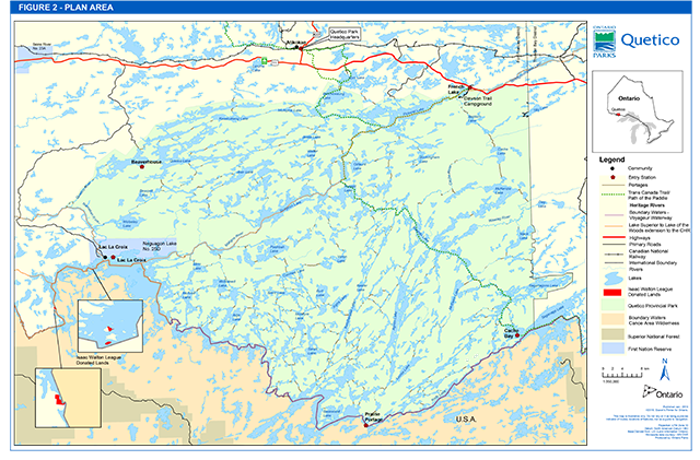
The community of the Lac La Croix First Nation, known as Zhingwaako Zaaga’iganing (Lake of the Pine Trees or Pine Tree Lake) abuts the southwest boundary of the park, where it spans 62.1 km2 along the northern shore of Lac La Croix (INAC 2005). This community of approximately 350 people is home to the Lac La Croix First Nation, and serves as a western administrative area for the park (see Figure 2 for local context).
Figure 1 Regional context
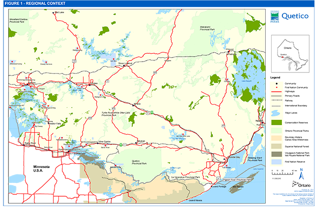
Expand Figure 1 Regional Setting
Figure 2 Plan area
The Township of Atikokan with a population of 3,000 is located immediately north of Quetico, and serves as base for park administration.
In 1909, Quetico Forest and Game Reserve was established to protect wildlife values. Earlier that same year, in the adjacent American state of Minnesota, the Superior National Forest was founded to enhance forest management. Quetico Provincial Park was regulated as a provincial park in 1913, and was classified as a wilderness park in 1977. There are no commercial tourism facilities located within the park boundaries, with the exception of a facility on private land used for commercial tourism on Batchewaung Lake. Quetico has had a management (master) plan in place since 1977 which has been reviewed and updated regularly (1982, 1988, and 1995). The park’s abundant waterways, rich cultural history, wild undeveloped landscape and relative lack of mechanized travel, all contribute to its reputation as an area of unparalleled wilderness canoeing opportunity (Figure 2).
The PPCRA, which governs activities within provincial parks, applies only to lands and waters within the regulated boundaries of parks and conservation reserves. Ontario Parks is committed to an ecosystem approach to park planning and management. This approach allows park managers to consider the relationship between the park and the surrounding environment. Park managers may consider potential impacts on park values and features from activities occurring on adjacent lands, and potential impacts from park activities on land uses in adjacent areas.
Park management plan policies apply only to the area within the regulated boundary of the park. Within the park boundary, the protection of park values and features will be achieved through appropriate zoning, control of land use and activities, education, and monitoring of ecological impacts.
Quetico Provincial Park is governed by Ontario’s PPCRA, Ontario Provincial Parks: Planning and Management Policies (OMNR 1992a) and Ontario’s Living Legacy - Land Use Strategy (OLL-LUS; OMNR 1999).
2.0 Classification
Through park classification, Ontario’s provincial parks are organized into broad categories, each of which has particular purposes and characteristics.
Quetico Provincial Park is classified as a wilderness park. The class target for wilderness parks is to establish at least one in each of Ontario’s 13 ecoregions. Quetico Provincial Park fulfils the representation target for wilderness class parks in ecoregion 4W. As a wilderness park, Quetico’s primary emphasis will be protection. The classification does not affect Treaty #3 communities, including Lac La Croix First Nation Aboriginal or Treaty Rights. The wilderness classification will also honour the deep spiritual sacrosanct connection with the land that is the cultural heritage of Lac La Croix First Nation.
Quetico Provincial Park is currently an operating park. A park operations plan has been prepared to provide park staff with the necessary direction to operate the park on a day to day basis. In addition to addressing the operations policies that follow, the plan includes such topics as budget, staffing, maintenance schedules, enforcement, education, and emergency services. The provisions of the plan will be consistent with the approved Ontario Provincial Parks Minimum Operating Standards, and will be reviewed annually and updated as required.
The operating status of provincial parks is determined by Ontario Parks based on visitation and use, analysis of revenue and expenditures, and infrastructure needs. Changes to a park’s operating status may be made by Ontario Parks without the provision of external involvement.
3.0 Vision
The vision for Quetico Provincial Park is:
3.1 Lac La Croix First Nation and its relationship with Quetico Park
An Agreement of Co-Existence negotiated in 1994 between the government of Ontario and the Lac La Croix First Nation, frames this relationship. The substantive elements of that agreement provided the basis for amendments to the 1995 plan and it continues to provide direction in this plan. As of 2015, the Agreement of Coexistence is undergoing a joint review. If a renewed agreement is finalised it will also provide direction to this plan and if necessary a plan amendment will be undertaken to address any new direction.
4.0 Objectives
Quetico will be planned, managed and operated as a wilderness park in accordance with the PPCRA: “The objective of wilderness class parks is to protect large areas where the forces of nature can exist freely and visitors travel by non-mechanized means, except as may be permitted by regulation, while engaging in low-impact recreation to experience solitude, challenge and integration with nature.” 2006, c. 12, s. 8 (2).
There are four objectives for Ontario’s provincial parks: protection, recreation, heritage appreciation and scientific research. Each park in the system may contribute in some way to each of these objectives, depending on its resource base. Quetico Provincial Park contributes to the achievement of all four objectives.
4.1 Protection
Ontario’s protected areas play an important role in representing and conserving the diversity of Ontario’s natural features and ecosystems across the broader landscape. Protected areas include representative examples of life and earth science features, and cultural heritage features within ecologically or geologically defined regions. Ontario’s ecological classification system provides the basis for the life science feature assessment, and the geological themes provide the basis for earth science assessment.
The protection objective will be accomplished through appropriate park zoning, resource management policies, research, and monitoring.
4.1.2 Earth science
Bedrock geology
Quetico Provincial Park lies on the southwestern portion of a vast area of ancient rock known as the Canadian Precambrian Shield (the Shield). The Shield forms the foundation of the North American continent and consists of some of the oldest rocks on earth. It is divided into provinces and subprovinces on the basis of overall differences in internal structural trends, age, lithology (rock types), metamorphic grade (alteration) and style of folding (Thurston 1991). Quetico Provincial Park lies within the Superior Structural Province of the Shield, and encompasses portions of two subprovinces, the Wawa Subprovince in the southeastern portion of the park, and the Quetico Subprovince in the remaining portion of the park. All the rocks within the park boundaries are of Archaean age, having last been affected by a major period of mountain-building during the Kenoran Orogeny some 2 700 to 2 500 million years before present.
A sedimentary-volcanic sequence known as the Poohbah Lake Complex is located at Poohbah Lake. It is an alkaline intrusive sequence comprising syenite and nepheline syenite associated with sheets of leucogranite. The complex is significant in that it is one of the oldest known alkaline intrusives in the Shield, with an age of some 2 700 million years (Williams 1991). The type locality
Two thirds of the park is underlain by granite, an acidic bedrock that results in a low variety of plant species and clearer, less productive lakes. Two larger areas of metasedimentary bedrock, one in the east and one in the west, result in soils that are deeper and richer with a higher diversity of plant species. In the southeast corner of Quetico is an area of metavolcanic bedrock, also referred to as greenstone. In contrast to the acidic soils of the granitic area, soils and lakes in this area tend to be basic due to the higher levels or calcium. Plant diversity is much higher and lakes tend to be more productive when compared to lakes in the rest of the park.
Surficial geology
In the Quetico area, the Wisconsinan Stage was witness to many advances and retreats of the continental ice masses, though only the features associated with the last of these, the Late Wisconsinan, are preserved. The ice withdrew from the area of the park for the last time about 11 000 years before present as the ice front stabilized briefly along the Steep Rock Moraine and the subsequent Eagle-Finlayson Moraine. Glacial Lake Agassiz was in contact with the ice margin along its northern shoreline, and covered most of the low-lying areas in the Rainy River valley (Barnett 1992).
Glacial and postglacial features and landforms left behind by the last glacial retreat in the park include two sets of glacial striae, reflecting local variations in the movement of the ice, segments of two recessional moraines (a type of end moraine) associated with ice-halt positions during the retreat of the final ice sheet, raised shoreline features and lacustrine deposits of glacial Lake Agassiz, and bare to sporadically mantled bedrock, the result of wave-washing of the Shield by the waters of glacial Lake Agassiz. The predominant surficial deposit in most of the park consists of a thin, discontinuous mantle of sandy till deposited as a ground moraine.
4.1.3 Life science
Quetico Provincial Park has a number of life science features that are of ecological, interpretive and educational significance. A number of significant communities are found in Quetico. These communities are of interest for a number of reasons. Some of the communities are biologically diverse, contain high levels of rare species, or are of value to the Natural Heritage Education (NHE) Program.
Quetico Provincial Park is situated in ecodistrict 4W-1, within the Great Lakes-St. Lawrence Forest Region, and borders the Boreal forests to the north and the Great Plains forests to the west and southwest. As a result, Quetico is characterized as containing a mixture of mostly northern, as well as some southern and western elements, resulting in a diversity of plant species typical of the different regions. To date, 666 plant species have been identified in the park, the majority of which are terrestrial. The aquatic plant community has not been sampled to the same degree, and there are likely many more plant species still to be recorded.
Efforts will be made to enhance protection of species at risk and to prevent and /or mitigate the introduction of invasive species.
Red and white pine communities
Although white and red pine trees are widely distributed throughout the park, large stands where they are the dominant species are relatively rare, making up about 10% of Quetico’s forest. Red and white pine stands are most common in an area from McAree to Kahshahpiwi Lake in the south of the park and from Sturgeon to Pickerel Lake in the north. A significant area of old white and red pine occurs in the vicinity of McNiece and Shan Walshe Lake. These forest communities are also significant for their fire research and natural heritage appreciation values.
Eastern white cedar communities
Extensive stands of eastern white cedar are largely absent from the majority of the park, but can be found on greenstone bedrock in the southeast corner of the park. Many of these communities are significant as old growth features. One significant old growth eastern white cedar community is found on Emerald Lake. Associated ground flora includes false Solomon’s seal, dwarf horsetail and blunt-leaved orchid. Another significant eastern white cedar community is located near Belaire Lake. This community is a pure cedar stand situated in a depression on metamorphic bedrock. Two southern species found here are jack-in-the-pulpit and blunt-leaved orchid, both of which are abundant here but locally rare.
Hardwood forest communities
A rich trembling aspen community on clay soil is found on Wolseley Lake. Because deep pockets of clay are rare in Quetico, the floristic diversity at this site is locally significant. Components of the community are Saskatoon berry, black snakeroot, white rattlesnake-root and purple oat.
Two forest communities that contain large red maple have also been identified. In the area between Poohbah and Berniece Lakes, the forest community is dominated by white birch and trembling aspen with an abundance of large red maple. Pure stands of red maple are found in the vicinity of Glacier Lake, where the red maple stands are smaller inclusions within a trembling aspen forest. These hardwood forests are rare in Quetico. In addition to their ecological value, they also have a high value for education and research purposes.
Mixedwood forest communities
A significant white pine and yellow birch forest community exists along the portage between Lindsay and Cache Lakes. This is the best and largest example of this community type found in the park to date. Yellow birch is locally rare in the park, and can only be found throughout the park as minor inclusions in other forest types.
Red oak is a hardwood species that is locally significant. In the park it is found in mixed forest communities, usually growing in association with red pine. Red oak is fairly abundant along the Maligne River and in the red pine stands in the Shan Walshe Lake area.
Open wetland communities
A number of bog communities in Quetico support locally rare orchid species. Swamp pink orchid and rose pogonia have both been documented at two bogs in the vicinity of Bearpelt Lake and Star Lake. Walshe (1980) noted that the Bearpelt Lake bog is significant as every stage of bog development can be found here.
Rich marsh communities are rare in Quetico. Bearpelt Creek Marsh is an extremely rich marsh and contains the only local occurrence of pickerel weed. Rich wetland communities are important for the high level of biodiversity present, and are also important moose aquatic feeding areas and provide important habitat for waterfowl.
Shoreline communities
Significant open shoreline communities that support prairie species exist along Lac La Croix in Martin and Rice Bay, and on Iron Lake. Locally rare freshwater cordgrass is generally found growing close to shore, with big bluestem growing higher on the shore in drier soils.
Floodplain communities
The physiographies of the Wawiag and Cache River floodplains are extremely rare in Quetico and northwestern Ontario. Deep glaciofluvial outwash and alluvial deposits of sands and gravels were deposited here when glacial Lake Agassiz occupied the area. In later, quiet-water times of the lake, silts and clays were periodically deposited in association with the nearshore and outwash sediments, creating an extremely fertile alluvium.
The floral diversity of the Wawiag River floodplain is perhaps greater than anywhere else in Quetico, with many southern and western species present. Near the mouth of the Wawiag at Kawa Bay, a silver maple community with white elm is found on the narrow levee. Fringed loosestrife and sessile-leaved bellwort are abundant in the herbaceous layer. Hawthorn spp. and chokecherry are co-dominant, with nannyberry and highbush cranberry common associates. Hops are also present at this site, found growing on the upright shrub species. Locally rare herbaceous species found in this forest community include smooth carrion flower, ostrich fern, and cow parsnip.
Within Kawa Bay, the provincially rare red-disked water lily is abundant, growing in association with softstem club-rush, river club-rush, and narrow-leaved floating burreed.
Farther upstream from this site at the Mack Creek junction is a white elm and red ash community with Manitoba maple occurring as a minor component. Wild ginger is found in this community and it is the only one of two known locations of this species in the park.
A number of significant floodplain communities exist along the Namakan River. A red ash – silver maple stand with bur oak can be found along the shoreline. Herbaceous flora associated with this community include: poison ivy, royal fern, small sundrops and sand cherry. Located behind the red ash - silver maple community is a trembling aspen – white elm community with a large component of basswood, bur oak and red maple. Associated with this community are many southern herbaceous plants including: sessile-leaved bellwort, carrion flower, false Solomon’s seal, and jack-in-the-pulpit, downy yellow violet and alternate-leaved dogwood.
Cliff communities
Provincially rare basic cliff communities are found along the Man Lakes Chain, Emerald and Ottertrack lakes and on a tributary of the Wawiag River. Other basic cliffs may exist in the park, but have not been reported to date. The Basic Open Cliff Type is provincially rare and ranked S3S4 (Bakowsky 2002).
Most of the basic cliffs in the park are covered in the calcium loving orange lichen, making identification of these cliff types quite easy. The north-facing Emerald Lake cliff community has a cooler than normal microsite that supports many arctic disjunct species including smooth cliffbrake, encrusted saxifrage, smooth woodsia, as well as two provincially rare species, limestone oak fern and snowy cinquefoil. Maidenhair spleenwort is also found at this location, and is only one of two known locations in the park. The other location is at a cliff found at the narrows on Agnes Lake, where the provincially rare limestone oak fern is also found. Disjunct northern and western plant species have persisted at these cliffs for thousands of years.
Mammals
Forty-three mammal species have been recorded to date in the park, representing 61% of Ontario’s mammal list (excluding non-native and marine mammals). Because of the relatively large size of Quetico Provincial Park and its position adjacent to the BWCAW, the combined protected area is able to support populations of species which require a relatively large home range and/or large portions of contiguous habitat. Such species found in Quetico include black bear, marten, and moose. Other large mammals found in Quetico include gray wolf, lynx, coyote and white-tailed deer.
Quetico Provincial Park contains the typical suite of small mammals for the area. A number of shrews, moles, bats, squirrels, voles, mice, and weasels can be found throughout the park. These include the northern short-tailed shrew, star-nosed mole, little brown bat, least chipmunk, woodchuck, woodland jumping mouse, deer mouse, meadow vole, southern bog lemming, red-backed vole, river otter and marten. Other species include fisher, porcupine, mink, red fox, and snowshoe hare.
Birds
As a result of Quetico’s transitional character, an overlapping of typically northern, southern, eastern and western species of birds occurs. Some representative species include: common raven, gray jay, black-backed woodpecker, black-capped chickadee, great gray owl, spruce grouse and many species of wood warblers, the Nashville, magnolia and mourning warblers being among the most common. Pine and evening grosbeaks, common redpoll, white-winged and red crossbills, pine siskin and purple finch are some of the very few bird species found in Quetico in the winter months.
Birds at the northern limit of their range include the black-billed cuckoo and indigo bunting while birds common to the western prairies such as the yellow-headed blackbird and western meadowlark have been observed. Quetico is known for its populations of bald eagle and osprey. All three accipiter species in Ontario are found in Quetico, including Cooper’s hawk, northern goshawk and sharp-shinned hawk.
Significant populations of waterfowl do not occur within the park. Common merganser, common goldeneye, black duck, mallard and common loon are the most common breeding species. Trumpeter swans have increased in Quetico over the past decade as a result of re-introduction efforts in Minnesota.
Reptiles and amphibians
Eight species of frogs, (including the northern leopard frog, wood frog, boreal chorus frog, and spring peeper), one species of toad (American toad) and two species each of salamanders (the eastern red-backed salamander and the blue spotted salamander), snakes (the common garter snake, and likely the red-bellied snake as it has been recorded in the Atikokan area) and turtles (the snapping turtle and the western painted turtle) have been recorded within the park. The western painted turtle is a subspecies of the painted turtle, and in Ontario this subspecies is only found in a narrow band in Northwestern Ontario along the Minnesota border. The snapping turtle is ranked as a species of Special Concern.
Fish communities
A total of 48 fish species have been reported in Quetico. The lakes within the park support fish communities that vary according to local lake characteristics. The broadest classification of these communities is according to coldwater and warmwater habitats. Coldwater communities can include lake trout, lake whitefish, cisco (lake herring), and burbot. Warmwater communities can include walleye, northern pike, smallmouth bass, largemouth bass, yellow perch, black crappie, rock bass, lake sturgeon
Invertebrates
Forty-nine species of moths and 31 species of butterflies have been identified to date in Quetico. Only one species has been designated a species at risk: the monarch butterfly is designated as Special Concern.
Dragonflies and damselflies are some of the more visible invertebrates in the park. Canada darners, dusky clubtail and chalk-fronted corporal are some of the most commonly encountered of the more than 50 dragonfly species in the park while river jewel and various species of bluet are frequently observed damselflies. The pygmy snaketail is a globally rare clubtail dragonfly ranked as a species of Special Concern. This dragonfly is known at only one location in Ontario at Lady Rapids on the Namakan River close to the western boundary of Quetico, where a single exuvium was discovered in June 2007.
4.1.4 Cultural features
Quetico Provincial Park contains a number of cultural features that are of historical and educational significance.
Respect for, and protection of, archaeological and cultural features is important to Lac La Croix First Nation as well as other Treaty #3 communities. Lac La Croix First Nation, and other communities have an established claim to inherent rights as set out in Treaties and by commitments made under Treaty #3 and by virtue of their proximity to Quetico Provincial Park; they will be involved in implementation of the plan.
The cultural heritage resources of Quetico Provincial Park are both plentiful and significant, representing major expressions of the Anishinaabe people of the boreal forest and Canadian Shield and their descendants, as well as Quetico’s role and importance to the fur trade period and to the exploration of Canada. Quetico’s rich archaeological past can be traced to its origins as part of the corridor between glacial lakes Agassiz and Minong through which the earliest inhabitants moved northeast as the glaciers retreated. The boundary waters corridor of Quetico has also been a major transportation route since the earliest times. The co-operation and partnership among the British fur traders, the voyageurs, and Indigenous people, including the Anishnaabe people, was a critical stage in the development of present day Canada, and international co-operation has been integral to the development and preservation of this extraordinary region.
The number of archaeological and pictograph sites found within the park reflects a high level of Anishinaabe, and earlier, peoples occupation (e.g., Paleo-Indian, Middle Shield, Woodland, Laurel and Blackduck cultures). The seasonally strategic lifestyle of the first inhabitants, the harsh terrain, and the acidic soils meant that relatively few small and scattered archaeological sites have been located (Dawson 1983, Wright 1995). The sites are often destroyed by rising water levels, invading forests, and acidic soils (Dawson 1983, Wright 1995). As a result, it is likely that many more artifacts may have existed than have been found to date, but were unable to withstand the ravages of time. Many portions of the park have not been explored archaeologically and those that have been surveyed have only been subject to cursory testing and, on rare occasions, limited excavation. As a result, available information about the long period of occupation by Anishinaabe people is incomplete. The park superintendent may close areas to camping in consultation with Lac La Croix First Nation and other Treaty #3 communities in order to protect known cultural values such as sacred sites, ceremonial sites, and burial sites.
An Indigenous rare breed of horse known as the Lac La Croix Indian or Ojibway Pony has a long association with the Quetico area. This is an extremely hardy and intelligent breed that was used by the people of Lac La Croix and Bois Forte (in Minnesota) for hauling, logging, running trap lines and for transportation and other work in the winter. The last four surviving ponies were removed from the Lac La Croix community in the 1970s and a breeding program was established in the 1990s to save the breed. The Seine River First Nation has several of these ponies at the Grey Raven Ranch which is run as a non-profit to provide community youth with opportunities to work with the horses.
4.2 Outdoor recreation
In recent years, approximately 26,300 people visit Quetico each year, with 118,000 camper nights (# visitors X length of stay) spent in the park. Approximately 8,200 people visit the campground each year, resulting in 15,000 camper nights in the campground. Approximately 18,000 people visit the interior of the park each year, resulting in 103,000 camper nights. Since the last management plan review in 1995, there has been a gradual but steady decline in the number of interior park visitors. In 2014 there were 11,333 interior visitors and 2,786 campground visitors, as well as 1,581 day users.
A 2011 visitor survey indicates that in 2011 83% of park visitors were from the U.S. and 60% of interior visitors entered through the southern boundary of the park. The 2011 Quetico Provincial Park Interior Visitor Survey asked respondents to provide their entry point: 38% of visitors entered via Prairie Portage; another 20% of entries were associated with the Cache Bay Entry Station: these figures represent 58% of entries through the two southern entry stations and eight entry points. Dawson Trail and Atikokan accounted for 31% of all park entries via the northern entries with Pickerel entry point at 16%, Batchewaung at 8% and Cirrus Lake/Sue Falls/Baptism Creek at 7%. Beaverhouse entry station accounted for 9% of entries and Lac La Croix entry station accounted for 6%.
Outdoor recreation will be encouraged to the greatest extent possible without adversely affecting the park environment or visitor experiences.
4.2.1 Quetico interior
To provide high quality, low intensity, wilderness experiences by providing ecologically sustainable outdoor recreation opportunities for extended non-mechanized travel and associated activities throughout the park’s interior.
The interior of Quetico Provincial Park offers a variety of recreation opportunities, in an array of natural settings. Recreational activities in Quetico are limited to primitive forms of travel, as well as those activities that are associated and compatible with primitive travel. The types of non-mechanized travel provided for have only been those consistent within the historical context of the park. Permitted activities include:
- Canoeing/kayaking
- Camping (back country)
- Sport fishing
- Motorized guiding on designated lakes by members of the Lac La Croix Guides Association
- Nature Appreciation
- Photography/Painting
- Hiking
- Snowshoeing
- Cross-country skiing
4.2.2 French Lake and the Dawson Trail Campgrounds
To provide high quality, moderate intensity, threshold wilderness experiences by providing ecologically sustainable outdoor recreation opportunities/or non-mechanized travel and associated activities based from the Dawson Trail car campground and day-use facilities.
The recreation objectives will be achieved through appropriate park zoning; the identification of management policies to prevent any compromise of significant natural and/or cultural heritage values or the ecological integrity of the park; market research and monitoring; and mitigating impacts of recreational use. Permitted activities include:
- Canoeing/kayaking
- Camping (car camping)
- Roofed accommodation
- Sport fishing
- Nature Appreciation
- Photography/Painting
- Hiking
- Snowshoeing
- Cross-country skiing on groomed trails
- Bicycling (including mountain bikes) on park roads
- Day use activities
- Education programs
4.3 Heritage appreciation
To provide opportunities for structured and unstructured individual exploration and appreciation of the natural and cultural heritage of Quetico Provincial Park.
This objective will be achieved through the park’s Education Program, structured and unstructured individual park exploration, and through the efforts of other groups such as the Friends of Quetico Park, the Quetico Foundation, the Lac La Croix First Nation, Lac des Milles Lacs First Nation and Seine River First Nation. Education is discussed in Section 8.4.
4.4 Scientific research
To facilitate scientific research and to provide points of reference to support monitoring of ecological change on the broader landscape, as well as to enhance the historical record and to support the preservation of Anishinaabe culture.
Ontario’s provincial parks play an important role in the provision of places to undertake research activities to: provide a better understanding of park environments, contribute to appropriate park management practices and actions, to contribute to cultural and historic knowledge and to provide baseline ecological information that can be used to support ecological monitoring on the broader landscape.
Quetico Provincial Park provides many opportunities for research by Ontario Parks and other MNRF staff, Lac La Croix First Nation, academic researchers and the Quetico Foundation. Research is discussed in Section 8.7.
5.0 Boundary
Quetico Forest and Game Reserve was created in 1909. Quetico was regulated as a provincial park in 1913 and classified as a wilderness class provincial park in 1977.
Park management plan policies apply only to the area within the regulated boundary of the park. Within the park boundary, the protection of park values and features will be achieved through appropriate zoning, control of land use and activities, education, and monitoring of ecological impacts (Figure 3).
Quetico Provincial Park surrounds several patent land parcels, totalling 74.26 ha in area. These lands are not subject to the PPCRA or park regulations. Many are the result of mining claims staked during and after World War II. As they become available, the titles to the mineral and surface rights for all mining claims, patents and licences of occupation located within the park will be acquired by the Crown. Lac La Croix First Nation will be notified when a piece of patent land reverts to the Crown or when Ontario moves to purchase a parcel that comes up for sale.
The Minister of Natural Resources, under the authority of Section 13(1) of the Public Lands Act, R.S.O. 1990, may designate any area in the unorganized territories of Ontario as a restricted area. As the designation grants MNRF significant control over activities on private land, restricted areas are created by regulation to ensure full oversight of the process. The construction of any building or structure or improvement in the restricted area requires prior approval by a permit issued by the MNRF. Current restricted areas surrounded by Quetico Provincial Park are listed in schedules 2 and 4 of O.Reg. 150/12. These restricted areas will continue to control development of private lands surrounded by the park.
Figure 3 Land use and development
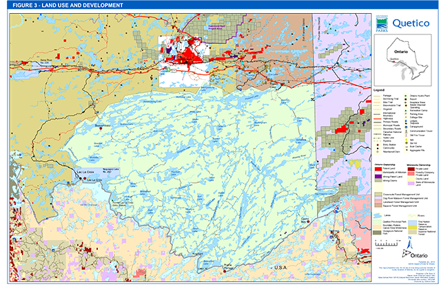
Expand Figure 3 Land Use and Development
There are 3 Crown-owned properties (2 islands and a mainland parcel at Beatty portage) on Lac La Croix that were donated by the Izaak Walton League of America Endowment to Ontario in 1970 with the expressed purpose of wilderness protection (Figure 2). One island (parcel # CL 155) and the mainland parcel are regulated as Lac La Croix Wilderness Area under the Wilderness Areas Act. The other island (parcel # BG372) is included in the general use area (G2564). The reasons why this parcel is not included in the Wilderness Area will be investigated. Land use planning will be initiated for the Lac La Croix Wilderness Area and G2564. This process will determine whether these areas will be added to Quetico Provincial Park, or will be granted some other land use designation. Lac La Croix First Nation has expressed an interest in future land use planning for the three Crown patent properties donated by the Izaak Walton League.
The last park boundary adjustment occurred in 2014 when one parcel (64 ha) near Veron Lake was added to the park. This parcel (PIN 56067-0026) reverted to the Crown in 1936 for tax arrears. All forms of private land tenure surrounded by park will, in due course, be acquired by the Crown. Negotiations to acquire the remaining private land holdings will continue as funds and priorities permit.
A property plan will be prepared, approved and kept current for the park. It will provide guidelines for the acquisition, maintenance, operation and abandonment of all tenured land holdings.
6.0 Park zoning
Zoning is a key part of a park management plan. Zones fulfill a variety of functions that may include:
- Recognizing the features and attributes of a park;
- Delineating areas on the basis of their need for protection or their ability to protect provincially significant representative features;
- Delineating areas on the basis of their ability to support various recreational activities; and,
- Identifying uses that will protect significant features, yet allow opportunities for recreation and heritage appreciation.
Management of the park’s resources is consistent with policies in Ontario Provincial Parks Planning and Management Policies (OMNR 1992a) and OLL-LUS. To date, two types of zones have been employed to guide Quetico’s resource management, operations and development; central wilderness zones 1 and 2 (W1 and W2) and peripheral access zones (entry stations).
The W1 and W2 zones are being consolidated and renamed the W zone. Two additional zone types are being added in this plan. Historical and nature reserve zones include the French Portage cultural heritage zone, and the Wawiag River Floodplain and the Emerald Lake Basic Cliff Communities nature reserve zones.
6.1 Wilderness zone
Wilderness zones (W) include wilderness landscapes of appropriate size and integrity which protect significant natural and cultural features and are suitable for wilderness experiences, as well as a protective buffer with an absolute minimum of development.
Wilderness Zone 467,581 ha
The wilderness (W) zone, as shown in Figure 4, occupies all but about 4,279 ha of Quetico’s approximately 471,878 hectares. Because of its dominance within the park, the wilderness zone is the focus of the detailed policy outline as contained in the following sections. Development will be limited to back country campsites, portages, and trails. Wilderness campsites will offer limited facilities such as firepits. Box privies may be installed on sites close to entry points and on major travel routes that experience heavy use or where there is a risk to the environment.
The W zone is comprised of ninety-nine percent of Quetico’s land base, including all park lands not zoned as access, nature reserve or historic zones.
Two parcels of land, the first parcel formerly part of access zone A2, the second island of two islands at Cache Bay, and the second parcel a former part of access zone A4 at the end of the Beaverhouse access road, have been added to the W zone.
Management intent:
The revered qualities of Quetico, as identified in the park’s goal and objectives will be preserved in this zone. This wilderness zone will remain the domain of natural processes; the presence of the recreationist will be that of a privileged visitor, activities will be restricted to those not compromising the integrity of the biophysical base. Mechanized forms of recreational travel will not be permitted with the exception of the Lac La Croix Guides Association (LLCGA) under the guidelines listed in section 8.2.1.
A shared resource management decision making regime between Lac La Croix First Nation and the Quetico administration will be designed and implemented.
Figure 4 Wilderness and nature reserve zones
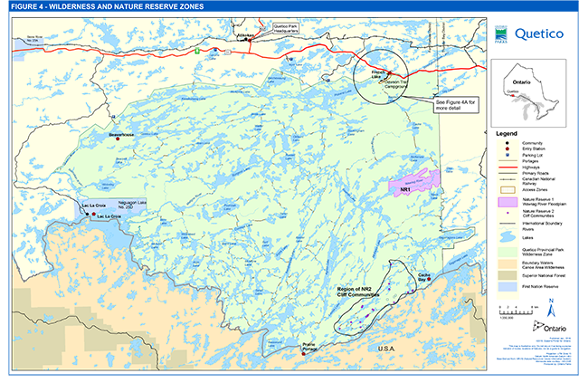
Expand Figure 4 Wilderness and Nature Reserve Zones
6.2 Nature reserve zones
Nature reserve zones (NR) include any significant earth and life science features which require management distinct from that in adjacent zones, as well as a protective buffer with an absolute minimum of development.
NR1 Wawiag River Floodplain 4,976 ha
The physiography of the Wawiag River floodplain is extremely rare in Quetico and northwestern Ontario. Deep glaciofluvial outwash and alluvial deposits of sands and gravels, silts and clays were deposited creating an extremely fertile alluvium. The floristic diversity of the Wawiag River floodplain is perhaps higher than anywhere else in Quetico, with a high number of southern and western species present. For a detailed description of this floodplain community refer to section 4.1.2.
NR2 Basic Cliff Communities 33 ha
Provincially rare basic cliff communities are found along the following lakes: Blackstone (1), Other Man (3), Ottertrack (10), This Man (3), Littlerock (2), Emerald (12), Fisher (1), Sheridan (1) and on a tributary of the Wawiag River. The Basic Open Cliff Type is provincially rare and ranked S3S4 (Bakowsky 2002). This zone is delineated as all of the cliff faces on the listed lakes.
Disjunct northern and western plant species have persisted at these cliffs for thousands of years. Since deglaciation, the surrounding vegetation has undergone drastic changes, while tundra and prairie plants were able to persist in open cliff habitats as the surrounding landscape became forested (Bakowsky 2002). For a detailed description of this basic cliff community refer to section 4.1.2.
Management intent:
The NR zone designation recognizes the fragility of these resources. Only scientific, educational and interpretive use is permitted in this zone. Some minimum impact recreational activity such as hiking is acceptable, provided there is no potential for features to be impacted. Development is limited to trails, directional and interpretive signs and temporary facilities for research and management.
Rock climbing and scrambling, back country camping, and mechanized travel are not permitted in nature reserve zones. Existing campsites in nature reserve zones will be closed and rehabilitated. Commercial trapping in NR zones by Lac La Croix trappers is permitted. Designation of nature reserve zones does not affect Aboriginal or Treaty Rights and associated traditional uses such as camping, hunting, fishing and harvesting medicines.
6.3 Historical zone
Historical zones (HI) encompass the provincially significant cultural resources of a park. They generally focus on a specific site (e.g., area of human occupation site, building(s)) and that site’s relationship to the surrounding landscape, and may include a protective buffer around the main feature in the zone.
H1 French Portage 36.2 ha
The French Portage runs three kilometres from the mouth of the French River, at the west end of Windigoostigwan Lake to French Lake. The French Portage is part of the historic Kaministiquia River fur trade route used by the French as well as the British. The Northwest Company and the Hudson Bay Company both used this travel route. It was also used by Anishinaabe peoples prior to the arrival of Europeans. In the 1860s it was part of the Dawson Route from what is now Thunder Bay (Fort William) to Winnipeg (Fort Garry). The French portage historic zone is comprised of the parcel of land on the north side of highway 11 that was added to the park in 1968 to encompass the area of a way station on the French portage (Figure 4A). Excavations of the way station site undertaken by Ken Dawson of Lakehead University yielded a 1871 five cent piece, square nails, and a straight boot - (left and right footed boots were introduced in the 1860s) - in addition to many other artifacts (Dawson and Klinefelder 1971).
The eastern landing of the French Portage (at the west end of Windigoostigwan Lake) was painted by Paul Kane in 1846. Paul Kane (1810-1871) was an artist who was one of the first Canadian artist-explorers to record life in the Canadian Northwest before European settlement, over two journeys between 1845 and 1848 (Noftall 2006).
In the summer of 2006, Ken Lister of the Royal Ontario Museum, discovered that one of Paul Kane’s paintings ‘French River Rapids’ had been painted at the east end of the French Portage at Quetico, not at the French River at Georgian Bay on Lake Huron as it had previously been identified. Paul Kane’s own journal makes reference to a sketch at this location and Lister confirmed this by locating the exact site of the painting. This painting portrays an important stage of Ontario’s transportation history and the history of Quetico Provincial Park; the French Portage is a part of this history, as are the historic and prehistoric travel routes that traverse Quetico Provincial Park)
Management intent:
Day-use activities (e.g., hiking and viewing) are permitted in historical zones. Camping is not permitted in historical zones. Development is limited to trails, necessary signs, interpretive, educational, research and management facilities, and historical reconstruction where appropriate.
Interpretive displays recounting the story of Paul Kane’s painting and the fur-trade era use of the French Portage as depicted in the painting will be included in the Education program at the Dawson Trail pavilion.
Ontario Parks and Seine River First Nation will work together to educate park visitors about the relationship of the Lac La Croix/Ojibwa ponies to the First Nations and to the park area, including visits to the Dawson Trail Campground with the ponies and potential use of the French Portage trail in this zone.
Ontario Parks will work with the Ministry of Transportation to ensure that any upgrade or replacement of the highway bridge adjacent to the Kane site will consider design considerations to facilitate safe pedestrian access. A small parking area may be developed to access the French Portage.
Figure 4A Zoning and development detail
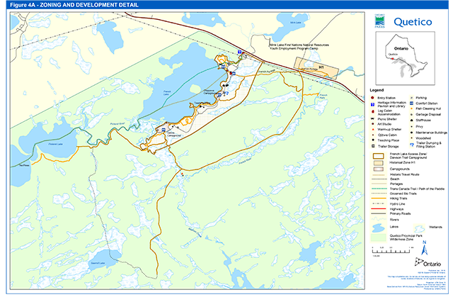
Expand Figure 4A Zoning and Development Detail
6.4 Access zones and entry stations
Access zones (A) serve as staging areas, where minimal facilities support the use of other zones such as wilderness zones. Access zones serve to provide access and regulate use to areas of a park geared towards extensive recreation.
Quetico is served by six entry stations (Figure 5). Beaverhouse Lake, French Lake and Nym Lake provide northern entry opportunities and are accessible by road. Cache Bay (Saganaga Lake) and Prairie Portage (Basswood Lake) are located on the southern boundary and are accessible by water only. Lac La Croix entry station was relocated adjacent to the village of Lac La Croix in 1997. Entry stations provide route information, interpretive information, permit issuing services and also serve as an emergency contact.
Five access zones, each with an entry station, were designated in the former plan. All of these zones have been retained (Figure 5).
The French Lake access zone (A1) (230.4 ha) contains the Dawson Trail Campground, staff quarters and offices, the Heritage and Information pavilion and John B. Ridley Research Library, day-use areas, the Teaching Place Roundhouse, and interpretive, hiking and cross country ski trails.
The Cache Bay access zone (A2) (3.1 ha) consists of one small island on Saganaga Lake. The island contains the entry station with staff quarters, the entry station office, and a storage garage, an aircraft landing dock, and a solar powered composting privy for park visitors. Another island was once part of the A2 zone, as it had a cabin for interior crews, which was removed in the early 1990s. This second island has been added to the W zone.
Prairie Portage access zone (A3) (6.1 ha) consists of a peninsula of land adjacent to the Canada - U.S. border between Basswood Lake and Sucker Lake. The entry station has staff quarters, an aircraft landing dock and a hydro-electric powered composting privy for park visitors. The Canada Customs facility ceased operation in 1996 and Ontario Parks has since used the buildings to operate the entry station office, a park’s store and to provide accommodations for entry station staff and interior crews. Upgrades to these facilities occurred from 2006-2008.
Beaverhouse access zone (A4) (8.5 ha) consists of one parcel of land on the shore of a small bay on Beaverhouse Lake. This lakeside parcel contains the entry station facilities which include staff quarters with the entry station office, an aircraft landing dock and a small cabin for interior crews. The Beaverhouse entry station is operated and staffed by Lac La Croix First Nation. There is a historic fire tower adjacent to the access zone. The part of the access zone that was formerly at the end of the access road has been added to the W2 zone.
Lac La Croix access zone (A5) (5.5 ha) is the site of the former entry station. The Lac La Croix entry station was re-located outside of the park near the village of Lac La Croix in 1997, where it is now operated and staffed by members of Lac La Croix First Nation. The A5 site was used by Lac La Croix First Nation for a youth camp and the zoning is being retained to enable future compatible use of the site by the First Nation.
The Stanton Bay forest access road, is located outside of the park boundary north of Pickerel Lake, and provides an alternative entry for Pickerel Lake with a parking lot (also outside of the park) and a boardwalk portage to Stanton Bay. Overnight parking at this location is restricted to Canadian citizens. Due to the fact that the road and parking lot are adjacent to the park boundary access zoning is not required at this location.
Two entry stations are located external to the park.
The Atikokan Area MNRF office, which is located in Atikokan, houses the Quetico Provincial Park headquarters, as well as the Atikokan entry station. Entries through Batchewaung (via Nym Lake) as well as entries through Sue Falls (via Lerome Lake) are processed at this station. Entry to the park via Batchewaung Lake is reached through Nym Lake, located outside of the park. Quetico Provincial Park maintains facilities at Nym Lake which include parking, vault privies and a dock. Parking is available at Lerome Lake for entry into the park via Sue Falls/Cirrus Lake.
A new entry point will not be considered for the eastern boundary of the park due to concerns regarding the availability of resources for construction and maintenance, road use compliance enforcement, visitor dispersal, and uncertainties regarding long term road access (maintenance) via the sustainable forest licence (SFL) holder. The Mack Lake entry location will be changed to Cullen Lake via the portage from Ross Lake. Aircraft will not be permitted to land on Mack Lake but will land instead outside of the park on Ross Lake. Three entries per day are permitted on Mack Lake. The Mack Lake aircraft landing will be removed from regulation.
Additional designation or improvement of access will be contingent upon site selection and visitor use.
Figure 5 Access zones

Management intent:
A major emphasis in the planning and management of Quetico is the development and improvement of opportunities for northern access. The implementation of this basic policy will achieve a number of important objectives. Additional northern entry opportunities will facilitate the use of Quetico by Canadians and, in particular, residents of Ontario. In providing viable alternatives to the traditionally heavily used southern entry points, these entry opportunities will encourage user redistribution within the park. The resulting increase in user activity in areas adjacent to the park’s northern boundary will tend to increase the economic impact of Quetico on the surrounding local Atikokan area.
New development may include staff accommodation and administrative facilities, signs, tertiary roads, overnight camping facilities, and facilities for education, or for research and management. Any development will be subject to the availability of financial and human resources, and carried out in accordance with an approved site or development plan, as well as Class EA-PPCR requirements.
The A5 zone will enable future park access related tourism activity by Lac La Croix First Nation with cultural/ ecotourism, youth facility and or a healing facility. The zone boundary will be adjusted to include the old portage. Cultural trails may be established from the A5 zone to Warrior Hill and to the Painted Rocks.
7.0 Resource stewardship policies
This section presents the detailed site objectives and management actions for Quetico Provincial Park. Implementation of the actions is subject to a number of conditions, including:
- applicable legislation and provincial policy;
- Class EA-PPCR;
- the availability of financial and human resources
- preservation of the cultural values of Anishinaabe people and,
- shared resource decision making with Lac La Croix First Nation
Resource stewardship initiatives may be accomplished through partnerships and sponsorships.
An adaptive management approach will be applied to resource management activities within Quetico Provincial Park. Adaptive management allows for the modification of management strategies in response to monitoring and analysis of the results of past actions and experiences. Adaptive management is a systematic, practical approach to improving resource stewardship.
7.1 Anishinaabe and Métis uses of natural resources
Quetico Provincial Park is located within the boundaries of lands covered by Treaty #3. All members of Treaty #3 have an established claim to inherent rights as set out in Treaties.
Quetico Provincial Park is located in proximity to three Métis Nation of Ontario (MNO) asserted harvesting territories as of 2015. The closest Community Councils that may have an interest include Northwest (Dryden), Kenora, and Sunset Country (Fort Frances/Atikokan).
Quetico Provincial Park overlaps traditional lands and waters of these Anishinaabe and Métis communities. Lac La Croix First Nation, Seine River First Nation, Lac des Mille Lacs First Nation and other Treaty #3 First Nations use the area for hunting, trapping, fishing, wild rice harvesting, medicinal harvesting and ceremonies; and other gathering and travel, and may continue to do so in accordance with section 35 of the Constitution Act, 1982. The Anishinaabe spiritual connection to the lands and waters of the park area is a sacrosanct relationship.
Lac La Croix First Nation and Quetico Provincial Park will collaboratively develop a park access plan that assures the community’s preferred means of access including power boat and aircraft access to Anishinaabe resources for spiritual and cultural purposes. Cultural access is at the discretion of the Chief and Council, under advisement from Lac La Croix Elders, and notice to the park superintendent.
7.2 Land management
Land management in Quetico Provincial Park will strive to protect the natural landscape by permitting the forces of nature to function freely, only taking action where necessary to preserve the ecological integrity of the park and the wilderness integrity of its features.
The management of the park’s land base will be directed towards maintaining the natural landscape. Ontario Parks will not dispose of protected area land to individuals or corporations for private use.
If any lands within, nearby or adjacent to the park become available for acquisition; they will be evaluated for purchase with regard to their contribution to park objectives, willing seller/willing buyer and other factors including available funding.
Solid waste will be disposed of outside the park at approved locations.
The Hydro One corridor that runs east west across the northern boundary through the Dawson Trail Campground (in A1) will continue to be administered through a land use permit (LUP).
Ontario Parks will pursue the designation of Dark-Sky Preserve by the Royal Astronomical Society of Canada to enhance the protection of the quality of the night sky over Quetico Park by minimizing light pollution. A Dark-Sky Preserve is an area in which no artificial lighting is visible and active measures are in place to educate and promote the reduction of light pollution to the public and nearby municipalities.
7.2.1 Industrial/commercial uses
The following uses are not permitted within the Quetico Provincial Park boundary:
- Commercial forestry.
- Prospecting, staking mining claims, advanced exploration, working mines.
- Extraction of sand, gravel, topsoil or peat.
- Commercial electricity generation.
- Other industrial uses.
7.3 Commercial tourism services
Ontario Parks will continue to support the existing tourism-based economic activity which benefits the Lac La Croix First Nation and the Town of Atikokan and surrounding area. The provision of guiding and outfitting services from bases outside Quetico Provincial Park will be encouraged, consistent with the park goal and objectives.
The establishment and use of commercial outpost camps within the park is prohibited.
Ontario Parks and Lac La Croix First Nation will practice shared resource decision making when exploring cultural and ecotourism opportunities associated with A5 (Lac La Croix access zone) and the current Lac La Croix Entry station.
7.4 Adjacent land management
Lands designated as General Use Area
Surrounding land uses include commercial trapping, commercial bait harvesting, commercial forest operations, commercial tourism, mineral exploration, and hydro-electric power generation. In the area adjacent to the eastern boundary of the park, mining claims continue to be staked and mineral exploration and development is ongoing. Exploration is focusing on gold deposits as well as volcanogenic massive sulphide deposits of copper and zinc. The revised terms of reference for an individual environmental assessment for the Hammond Reef Gold project were released in January 2012, and permitting is underway
There are active proposals for mines on public lands in the Superior National Forest adjacent to the BWCAW in Minnesota. One of these is the high profile Twin Metals proposal for an underground mine for the extraction of copper, nickel and other metals near Ely, in the Rainy River watershed that flows north and west into the BWCAW, and then out of Minnesota into Quetico and Rainy Lake.
Ontario Power Generation’s Atikokan Generating Station is located approximately 20 km to the north of the park near the Town of Atikokan. It originally consisted of one coal-fuelled generating unit that produced up to 211 megawatts (MW) and was recently converted to wood fibre biomass (pellet fuel).
A small part of Quetico Provincial Park in the Batchewaung Lake area abuts the municipal boundaries of the Township of Atikokan. The Official Plan for the Township identifies the watershed of Quetico Provincial Park as an area of resource management and land use activities where the protection of park values should be considered. The values of Quetico Provincial Park within the Township of Atikokan include critical landform vegetation types, wilderness zone (mechanized travel not permitted in this area), Trans Canada trail (non-mechanized travel only) and an entry point to the park (Batchewaung Lake via Nym Lake). Development proposals will be reviewed by MNRF and Ontario Parks staff to determine impacts on the park and possible mitigation/minimization methods.
The development of 4 hydroelectric projects on the Namakan River was initiated several years ago. The project design was subject to a proponent-led EA process and Ontario Parks was part of the agency review. Concerns with the proposal, which included upstream impacts to Quetico Provincial Park water levels and the environmental assessment process itself, were identified and the EA was suspended in the fall of 2011. In 2012, the EA process was re-initiated for one of the original hydroelectric projects at High Falls with a new design intended to prevent impacts to Quetico Provincial Park water levels. The project was cancelled in 2013, and there has been no recent activity associated with hydroelectric development on the Namakan River. Ontario Parks will participate in the agency review of the EA process for any future hydroelectric proposal.
When Ontario Parks staff review development proposals on adjacent land, impacts of the proposal on ecological integrity, water quality, the experience of remoteness, noise levels, viewscapes, travel routes and wilderness integrity will be considered. Ontario Parks will discuss development proposals with Lac La Croix First Nation to ensure that both park values are protected and that Anishinaabe cultural values are protected.
Quetico Provincial Park forms part of the Rainy Lake watershed and lies north of the international boundary waters between Canada and the U.S. (Figure 1). The Canadian waters were designated by the Canadian and Ontario governments as part of the Boundary Waters-Voyageur Waterway, a Canadian Heritage River, in 1996. The southern boundary of the park is contiguous with the BWCAW within the Superior National Forest, while Voyageurs National Park abuts the international boundary to the west of Quetico. This 1,000,000 hectare suite of protected areas surrounds the historical travel corridor along the boundary waters between Lake Superior and Lake of the Woods, and has many historical, natural heritage, and recreational interpretive themes in common with Quetico.
7.5 Vegetation management
Management of vegetation within the park will be directed towards the maintenance of an evolving natural succession of communities, and natural disturbances (fire, blowdown). The Quetico Provincial Park Fire Management Plan is used to accomplish vegetation management objectives such as renewal of pine stands.
Trees may be removed to enable resource management or facility development specifically authorized by this plan, an approved secondary plan, site plan, or development plan.
Any development that requires the removal of vegetation will be supported by a vegetation inventory in accordance with approved site plans and available resources. Ontario Parks will work with Lac La Croix elders and youth to provide opportunities to participate in any vegetation inventory and mapping projects.
Interior campers are to use deadwood for campfires.
The removal of hazard trees will be permitted in all zones where safety is a concern (e.g., portages, campsites, campgrounds). Areas experiencing adverse use impacts will be rehabilitated whenever possible using plant species native to the park.
Brushing along roads, hiking/skiing trails and portages will be permitted, as necessary, to improve sight lines and/or traffic flow.
Non-native plant species (plant species not native to Ontario or Quetico Provincial Park) will not be deliberately introduced to the park. If non-native plant species threaten natural heritage values or recreation values, a program for their eradication and/or control will be developed and considered. If biologically feasible and acceptable, extirpated native species may be re-established.
The occurrence of forest insects and diseases is recognized as an integral component of the park’s ecology. Infestations of forest insects and diseases will be monitored and assessed dependant on available resources. Non-native species may be controlled in all zones. If control measures are undertaken, they will be directed as narrowly as possible to the specific insect or disease, in order to have minimal effects on the balance of the park environment. Biological controls will be considered if appropriate.
Herbicide applications for vegetation management will be subject to written authorization of the park superintendent as per O. Reg. 347/07 Section 2(2) and 2(2)(a). Mechanized or hand tending of the Hydro One corridor that crosses the park through the French Lake access zone and W zone will be encouraged.
7.6 Forest fire management
Forest fire management within Quetico Provincial Park is directed through the Quetico Forest Fire Management Plan (1997, updated in 2009) which is consistent with The Wildland Fire Management Strategy for Ontario (2014) and the Fire Management Planning Guideline for Provincial Parks and Conservation Reserves (2011). MNRF is responsible for fire response in the park.
The first Quetico Provincial Park Fire Management Plan was approved in 1997. Quetico was divided into two distinct fire zones; the Measured Compartment and the Prescribed Natural Fire Compartment (PNF). The Prescribed Natural Fire Compartment comprised approximately 63% of Quetico’s land base. Fires in the Prescribed Natural Fire Compartment were candidates for a monitored or modified response based upon pre-identified criteria and the approved fire assessment report (FAR). If these criteria were not met, a full response was initiated.
In 2005, the scope of the fire plan was expanded to allow human-caused fires to be managed as prescribed fire, provided they occurred in areas pre-identified for renewal (e.g., insect infested stands, blowdown, decadent stands). As a result of this inclusion, the PNF Zone became the Prescribed Fire Compartment.
With the Quetico Provincial Park Fire Management Plan (2009) already in place, fire response remained largely unchanged with the implementation of the Wildland Fire Management Strategy for Ontario (2014). Other than minor changes in terminology, to provide consistency with this strategy, fire response within Quetico boundaries has remained the same.
The current fire management plan divides the park into four fire compartments: two managed fire compartments (1 and 2) and two prescribed fire compartments (3 and 4). Compartment 1 includes the northern boundary of the park where a higher level of protection is required to mitigate impacts to values in and adjacent to the Quetico boundary. Compartment 2 comprises approximately 63% of the Quetico Provincial Park land base. This compartment is located south of Compartment 1 and extends south to the international border, west to the community of Lac La Croix and southeast to the Thunder Bay District boundary. Compartment 2 will generally receive a monitored response based on an approved FAR. The two prescribed fire compartments identify where prescribed fire may meet specific ecosystem renewal and hazard reduction objectives necessary to maintain and improve the ecological integrity within Quetico. Compartment 3 is located in the north-central part of Compartment 2 and consists of 9,223 ha. The objective for this compartment is to address concerns regarding jack pine budworm damage in the central portion of the park with the goal of jack pine regeneration within this area. Compartment 4 consists of two areas in the south-western part of Compartment 2 and consists of 13,951 ha. The objective for this compartment is to maintain old growth red and white pine communities within these areas while promoting new regeneration of these species.
Fires originating in Minnesota that have the potential to cross the international border into Quetico Provincial Park will be assessed in consultation with Quetico Provincial Park managers, Fort Frances Fire Management Headquarters and representatives from the US Forest Service. Fires will be managed in accordance with the current Quetico Provincial Park Forest Fire Management Plan using appropriate fire response and/or fire use criteria and based on an approved FAR which will include the predicted fire behaviour, the potential impact of the fire on persons, property and values and the estimated cost of the response. The Quetico Provincial Park Fire Operations Plan provides communication linkages and standard operating procedures that are followed between the agencies involved.
Fires originating in Quetico Provincial Park that have the potential of crossing into the BWCAW are subject to the same process as described above. The BWCAW will not accept human-caused forest fires therefore these fires need to be managed accordingly to reflect this policy direction. Fires moving from BWCAW into a prescribed fire compartment in Quetico must meet the prescriptions assigned to these compartments to be considered as prescribed natural fire under the Quetico Provincial Park Fire Plan.
Culturally sensitive areas such as Kawa Bay and Warrior Hill will receive full suppression response and Lac La Croix First Nation will be involved in future reviews of the Quetico Fire Management Plan to identify culturally sensitive sites.
Fuel caches are not permitted in the park, with the exception of a cache at Prairie Portage entry station.
7.7 Water management
Approximately 21% (101,057 ha) of the total park area is comprised of water, with 2,943 lakes; 678 lakes are larger than 10 ha, while 2,265 lakes are smaller than 10 ha. A survey of 298 Quetico lakes indicated 36% (106 lakes) have cold water characteristics, and 64% (191 lakes) have warmwater characteristics (Tyhuis 2000).
Ultimately, all of Quetico’s waters drain to the west, through the Rainy Lake basin, the Lake of the Woods basin, the Lake Winnipeg basin, and finally into the Hudson Bay basin (Arctic watershed). It is important to note that several of Quetico’s secondary and tertiary watersheds do not all lie completely within its boundaries. As a result, activities and developments occurring outside the park, but within these watersheds, can have a direct impact on Quetico’s water quality.
Through the Crown Land Use Policy Atlas Policy Report G2624: Hinterland, the Quetico watershed is identified as an area of concern. Resource management and land use activities in the watershed will be carried out in consideration of the protection of values within the park.
Water quality along the boundary waters, requires continued co-operation with U.S. government agencies to ensure that Quetico’s values are not impaired.
Water quality data is being collected through the broad scale monitoring associated with Fisheries Management Zone 5.
There are two dams maintained in Quetico located on Pickerel Lake and Sucker Lake. The Pickerel Lake dam passively maintains water levels on this and adjacent lakes, and is unlikely to create substantial fisheries impacts. The Sucker Lake dam is used to maintain water levels south of the U.S. border and water levels are controlled through the International Joint Commission (IJC). Ontario Parks is not involved in the management of the Sucker Lake dam however, adjacent to the dam is a small hydroelectric generator that provides electricity to the entry station at Prairie Portage. This run-of-the-river hydroelectric generator is maintained by Ontario Parks.
Water levels within Quetico will not be manipulated by dams located in the park. Existing historic logging dams will be allowed to deteriorate, such as the log dam on Tanner Lake.
Quetico Provincial Park will continue to work with the Northwest Region MNRF to monitor the condition of the Pickerel Lake dam and to undertake remedial actions (such as repair or stoplog replacement) to prevent dam failure and to maintain the present water levels. Subject to available resources should extensive repair or replacement of the existing structure be required, the creation of a spillway or weir type dam will be considered.
Educational initiatives will be developed to demonstrate the sources and dangers of nutrient input. These programs will stress the need to bury grey water and human waste in pits far from waterbodies.
Public awareness programs will be developed to share information concerning the possible sources, extent, and consequences of external pollution.
Ontario Parks’ staff will provide input on the review of proposals for projects occurring in the park vicinity that could affect water quality or the hydrological regime in the park (e.g., hydroelectric, mining, and forest management).
The potable water system for the Dawson Trail Campground was replaced in 2003.
Drinking water quality will be monitored on a regular basis in the Dawson Trial campground in accordance with current Ontario Safe Drinking Water Regulations, and the Ontario Beach Management Protocol.
7.8 Fisheries management
The Quetico Provincial Park Fisheries Stewardship Plan was approved in 2006. As a wilderness park, the primary objective of the Fisheries Stewardship Plan is to maintain the biological integrity of the park’s aquatic ecosystems. This will enhance the wilderness experience of park users, and provide a protected wilderness ecosystem that can enhance research and fisheries assessment knowledge. The plan provides management direction for the protection of the ecological integrity of aquatic ecosystems in Quetico Provincial Park, and in turn the high quality fishing experiences associated with them.
With the development of Fisheries Management Zones as part of the Ecological Framework for Fisheries Management (2006), Quetico Provincial Park became part of the Fisheries Management Zone 5 (FMZ 5) in 2007. A Fisheries Management Plan for FMZ 5 was approved and implemented in 2014 and replaced the park’s Fisheries Stewardship Plan. A FMZ 5 subplan may be developed for Quetico with objectives for maintaining ecological integrity in the aquatic ecosystems of the park. Shared resource decision making between Lac La Croix First Nation and Ontario Parks staff would guide the development of a FMZ 5 subplan for Quetico Provincial Park. Currently, angling regulations in the park are the same as the rest of the zone with two exceptions, that only artificial baits and barbless hooks may be used. Analysis of 2010 Broadscale Monitoring data for Quetico Provincial Park concluded that the principle of ecological integrity is being met at the park scale under current zone management regulations. Quetico Provincial Park managers reviewed the proposed management actions and concluded that they will continue to maintain or enhance ecological Integrity. Because of this, general FMZ 5 angling regulations will continue to be applied to the park except for the two previously mentioned exceptions. Assessment data for both fish population and the aquatic ecosystem will continue to be analyzed separately for the park in the future to determine whether it continues to meet the principles of ecological integrity.
Ontario Parks will work with Lac La Croix First Nation to assess and monitor the ecological health of lakes in the park including those that are used for motorized guiding. Ontario Parks will work with Lac La Croix First Nation to provide opportunities for community members to be involved in lake health/fish population monitoring and assessment, as well as potential stewardship projects in Quetico including rehabilitation of fisheries habitat. Ontario Parks will work with Lac La Croix First Nation community members to build capacity towards participation in educational opportunities (e.g., warden training in order to act as fisheries officers, and other park positions).
Recreational fishing is permitted in the park subject to the Ontario Fishing Regulations. FMZ 5 regulation exceptions require the use of artificial lures and barbless hooks by park visitors in Quetico Provincial Park.
No commercial fishing licences exist, including bait harvest, nor have any been issued since 1968. No new operations are permitted.
Stocking of native species for the purpose of rehabilitation of native aquatic communities is permitted subject to the Class EA-PPCR. Stocking for the purpose of sport fishing is not permitted. Spawn collection for the purpose of research may be authorized by Ontario Parks research permit. Both activities are permitted in wilderness zones.
Anglers and other park visitors will be encouraged to prevent the introduction and movement of invasive species such as spiny water flea and Eurasian milfoil by cleaning and drying their canoes, boats and other equipment before entering park waters.
The use of alternative, non-lead tackle will be encouraged and educational initiatives will be developed to promote the merits of lead-free tackle.
Rehabilitation of fisheries habitat is permitted subject to the Class EA-PPCR.
7.9 Wildlife management
Quetico Provincial Park is located within Wildlife Management Unit 11C. Sport hunting is prohibited by the PPCRA.
There are presently 14 registered traplines wholly or partially within Quetico and, of these, 13 are operated by members of the Lac La Croix First Nation. These lines are located in the park’s northwestern, northern and northeastern sectors. Provincial park policy directs that, if an Anishinaabe interest has been identified for those traplines in Quetico not held by Status Indians exercising inherent rights as set out in Treaties, existing licences will not continue for the lifetime of the head trapper. Steps are underway to transfer these traplines to licenced members of Lac La Croix. Currently trapping is limited to the harvest of beaver and marten but the establishment of trapping agreement between Lac La Croix First Nation and Quetico may include the harvest of other fur bearing animals.
A number of traplines in the park are served by trapping cabins situated discretely away from shorelines and away from major canoe routes.
The relocation of existing development, including trapline cabins and trails etc. may be permitted but will be subject to an assessment of ecological impacts.
Licenced trappers are permitted to access their traplines using mechanized travel such as aircraft, all-terrain vehicle (ATV) or motorized snow vehicle (e.g., snowmobile) in areas designated by the park superintendent:
- Aircraft: The use of aircraft will be permitted between September 15 and May 1 with the approval of the park superintendent.
- Motorized snow vehicles and ATVs: The use of motorized snow vehicles and ATVs will only be permitted during the trapping season in areas designated by the park superintendent.
- Outboard motors: The use of outboard motors with an engine rating not exceeding 10 h.p., for the purpose of trapping activities is permitted during the trapping season.
The management of Anishinaabe trapping will be defined through negotiation of a trapping agreement with the Lac La Croix First Nation. This agreement will address administration, species limitation, quotas, cabin construction, and trapping on Hunter Island.
Wildlife habitat in Quetico will be managed through the use of fire for forest renewal. Non-native animal species will not be deliberately introduced to the park. If any non-native animal species threaten park values, a program for their eradication may be developed subject to the Class EA-PPCR. Extirpated native species may be reintroduced, and existing populations replenished subject to the Class EA-PPCR if biologically feasible, acceptable, and desirable in terms of perpetuating park values.
Opportunities for wildlife viewing will be encouraged in the park.
Mortally-wounded animals or individual animals may be controlled when essential to protect health and safety of park visitors or park facilities. Nuisance animals may be trapped and removed or dispatched under the supervision of, or directly by, Ontario Parks staff.
Ontario Parks and Lac La Croix First Nation will develop a protocol for found eagle carcasses to be delivered to Lac La Croix First Nation, as well as a protocol for Anishinaabe ceremonial requirements when an animal such as a black bear is dispatched in the park.
7.9.1 Species at risk
Species at risk and their habitat will be protected consistent with the ESA and regulations and Ontario Parks policy.
Assessment and monitoring of the park’s species at risk (e.g., lake sturgeon) and their habitat use may be undertaken to support wildlife management projects.
7.9.2 Alien and invasive species
An alien species is one that has been introduced to an ecosystem either accidentally or intentionally. These species may originate in other continents or countries, or from other parts of Ontario or Canada.
Alien species of flora and fauna shall not be deliberately introduced to the park.
Invasive species are species that are likely to spread and negatively affect native ecosystems. These species can include plants, animals, insects and diseases which may be managed where aesthetic, cultural, or natural values are threatened.
Visitors will be informed of species that may threaten park ecosystems if introduced.
Where possible actions will be taken to eliminate or reduce the threat of invasive species on natural biodiversity. Where alien species are already established and threaten park values, control strategies may be implemented where feasible, following established guidelines.
An invasive species plan will be prepared.
7.10 Cultural heritage management
The main cultural heritage values identified in Quetico Provincial Park include pictographs, archaeological encampment sites, burial sites, abandoned logging camps and old ranger cabins.
The management of cultural heritage resources in Quetico Provincial Park will be directed towards protection, heritage appreciation and research. Where cultural heritage resources may be impacted by any park projects or activities, MNRF will follow requirements as outlined in A Technical Guideline for Cultural Heritage Resources (2006) or other relevant cultural heritage policy. In the event of a discovery of additional archaeological sites, Ontario Parks will work with the appropriate authorities to identify and assess the significance of the site. Lac La Croix First Nation will share in decision making on all aspects of Indigenous archaeological discovery, reporting and assessment in the park.
Ontario Parks will consult with Lac La Croix First Nation, Seine River First Nation and Lac des Mille Lacs First Nation and Métis communities on matters pertaining to Anishinaabe and Métis history, any sites found within the park associated with Anishinaabe culture, interpretation of Anishinaabe history, and appropriate use of cultural artefacts. The precise location of any known or found Anishinaabe cultural sites, including burial sites, will not be disclosed to the public.
Ontario Parks will work with Lac La Croix First Nation to develop a response protocol regarding the discovery of cultural artefacts and the treatment of known cultural values such as pictographs. The protocol will address rules about what to do or not do, who to tell, how to treat pictographs, and will include the development of educational materials.
The removal of artefacts or destruction of historical features is illegal and is prohibited under the PPCRA.
7.10.1 Canadian heritage rivers system
The Canadian Heritage Rivers System (CHRS) is a cooperative program developed and run by the park administrations of territorial, provincial and the federal governments to give national recognition to the important rivers of Canada. The primary objective of the program is to ensure that those rivers which are outstanding examples of Canada’s natural and cultural heritage, as well as offering outstanding recreational opportunities, are protected.
The international waterway portions of Quetico, Pigeon River and LaVerendrye Provincial Parks were nominated as the Boundary Waters-Voyageurs Waterway under the CHRS. The nomination as a Canadian Heritage River was based upon its outstanding representation of natural, cultural and recreational values. With the completion of a management plan entitled “Managing the Boundary Waters-Voyageur Waterway as a Canadian Heritage River”, the waterway was officially designated by the Canadian Heritage Rivers Board of Directors in September, 1996.
A requirement of the CHRS is to prepare a monitoring report every 10 years for each designated heritage river. This report, entitled Boundary Waters-Voyageur Waterway, Ontario A Decade in the Canadian Heritage Rivers System 1996 – 2006, was completed in 2006 and includes a summary of the changes to the waterway’s natural and cultural heritage, recreational values; a brief description of the publications, reports and plans associated with the waterway; and an evaluation of the 1996 management plan and its implementation. The 2016 monitoring report and field work included the involvement of Lac La Croix First Nation youth. Future monitoring reports will include the involvement of Lac La Croix First Nation in the fieldwork and report development for the 10 year reports which are scheduled to occur in 2026 and 2036.
The Boundary Waters-Voyageur Waterway has maintained the qualities and values for which it was originally nominated since its designation in 1996.
A proposal to amend the existing designated route to recognize the early fur trade route from Fort William through Quetico was submitted to the Canadian Heritage Rivers Board in 2013 and is underway.
8.0 park operations policies
Operations policies deal with topics such as the NHE program, recreation management, and the provision of recreation services, business planning and research.
Restrictions in this section regarding the activities of park visitors do not apply to Lac La Croix First Nation, Seine River First Nation and Lac des Mille Lacs First Nation and Anishinaabe people under Treaty #3 exercising treaty rights.
8.1 Recreation management
Permitted recreational activities for park visitors within Quetico will include primitive/non-mechanized travel (e.g., canoeing, hiking, snowshoeing, and cross-country skiing), as well as those activities (e.g., camping, fishing, photography, and viewing) that are associated and compatible with non-mechanized travel. The types of non-mechanized travel provided for will only be those that are consistent with the historical context of the park. For example, although horseback riding and sailing may be considered as non-mechanized forms of travel, facilities for these activities will not be provided for within Quetico. In addition, the use of Quetico in the teaching or practicing of consumptive or destructive wilderness survival techniques will not be permitted. Similarly, those activities which may permanently deface the park landscape (e.g., use of pitons for rock climbing) will be prohibited.
Winter activities in Quetico include ice fishing as well as self-directed back country skiing, snowshoeing, and winter camping in the interior of the park. Commercial dog sledding will not be permitted anywhere in the park. Non-commercial dog teams of one to two dogs will be permitted. Non-commercial teams of more than 3 dogs may be permitted in the park subject to authorization by the park superintendent.
Groomed classic trails are available for day-use skiing in the area of the Dawson Trail Campground in the French Lake access zone. There is a rest stop at the old Camp 111 near Baptism Creek with a privy, a picnic table and fire ring.
Recreational activities that are deemed to be incompatible with the park goal or with specific zones are prohibited or restricted. Examples include adventure races, rock climbing and other high risk activities as described in park policy. Prevention and control of such activities will be achieved through education of park visitors regarding appropriate uses in the park in general and within specific zones, and through enforcement.
In keeping with Quetico’s wilderness ideal, the recreational use of all mechanical forms of transportation is prohibited as per regulation
Existing regulations prohibit the use of other motorized equipment such as chain saws, power augers and generators in the interior of Quetico Provincial Park with the exception of use for park management purposes.
8.1.1 Dawson Trail Campground
The Dawson Trail Campground was established in 1957 on French Lake, and provides a “window on the wilderness” to those not able or inclined to venture into the interior. Facilities are provided in the Chippewa and Ojibwa campgrounds for day-use, car-camping and interior access (Figure 4A). Campground amenities include: 106 campsites, 49 of which have electricity and 2 which are barrier-free, as well as 3 rustic cabins, comfort stations and day-use areas. Additional campground amenities include vault privies, potable water, trailer service facilities and a comfort station with shower and laundry facilities. Interior access facilities include a parking area and a canoe-launching site near the Ojibwa campground. Additional park amenities include the Dawson Trail Information Pavilion and the John B. Ridley Library as well as the Teaching Place Roundhouse.
All campgrounds and campsites will be monitored to ensure their continued viability. This will include necessary improvements to maintain the campgrounds according to Ontario Parks’ operating standards as funding becomes available.
The Dawson Trail Campground area will be managed in keeping with the character of Quetico, which may include non-mechanized recreation such as natural heritage education, hiking, cross-country skiing, skijoring (skiing while pulled by a dog), mountain biking (in designated areas), as well as providing staging for day trips and short overnight trips into the interior.
Ontario Parks will coordinate work where feasible with the Mink Lake First Nations Natural Resources Youth Employment Program to support the objectives of the Mink Lake First Nations Natural Resources Youth Employment Program whose facilities are located outside of the park adjacent to the Dawson Trail Campground.
The number of campsites within the Dawson Trail Campground will be limited to 106, with 49 of them electrical. Campsites or other areas in the Dawson Trail access zone may be used for alternative roofed accommodation
Ontario Parks will continue to support the John B. Ridley Research Library in its provision of valuable local provincial and international resources for wilderness management, research and education.
Roofed accommodation may be developed at the location of the old staff residence or set back an appropriate distance from the shore of French Lake between the two campgrounds in A1 to preserve and protect aquatic and riparian habitats from these developments.
8.1.2 Visitor regulation program (quota system)
The Visitor Regulation Program (VRP) for Quetico was created in 1977 with the approval of the original Quetico Provincial Park Master Plan. The VRP is based on the wilderness management philosophy of the park and the definition of wilderness. The VRP addresses existing uses, users, numbers, impacts; it highlights park regulations specific to Quetico; and establishes cycles for the collection of travel and visitor information data.
Various components of the VRP have been implemented to minimize the deterioration of both the park’s resources and the quality of the visitor’s experience. This has included the implementation of a quota system based on entry points and use areas, a reservation service to accommodate the quotas, regulations specific to the control of visitor impacts on park values, and a user education/orientation program.
The VRP quotas are based upon a defined recreational carrying capacity for the park. This capacity was derived from analysis of the recreational capabilities of both the natural resource base, the social setting for the wilderness experience and management practices to nurture wilderness settings. The capacity is presently defined as an entry quota of 68 parties (of up to 9 persons per party) per day, for a maximum of 69,165 persons annually over a 113 day operating season (mid-May until Labour Day). The carrying capacity, quota and reservation system may be revised and adjusted to reflect changes in use patterns and to support the maintenance or restoration of ecological integrity.
Visitors may continue to travel anywhere in the park that is not temporarily closed to travel, for reasons of safety, research and preservation. The superintendent in consultation with Lac La Croix First Nation and other Treaty #3 First Nations may restrict park visitor travel to culturally sensitive areas and may close campsites and/or areas of the park to travel for protection of culturally sensitive areas/sites.
Interior campsite occupancy is limited by regulation to one party per site. Maximum party size for interior use is limited by regulation to nine people.
Large groups travelling together are encouraged to limit themselves to a maximum of two parties, and to camp separately to minimize impacts on park resources and the experience of other wilderness visitors. These parties are required to have individual reservations and permits.
The use of non-burnable food and beverage containers (cans and glass bottles) in the interior is prohibited by regulation. All refuse which is not burned must be carried out of the interior by the park visitor.
There is no limit to the maximum length of stay in the park for individual parties
Maximum number of nights
-
- No person shall camp on an interior camp-site or in an interior camping zone for more than the maximum number of nights specified on the provincial park permit. O. Reg. 347/07, s. 16 (1).
- No person shall camp on a campground camp-site or unserviced camp-site for more than 23 consecutive nights or on an interior camp-site for more than 16 consecutive nights unless,
- the camp-site is available;
- the superintendent authorizes its continued use on the grounds that no adverse effect to the natural environment will occur as a result; and
- a new provincial park permit is obtained. O. Reg. 347/07, s. 16 (2).
. Limitations on length of stay may be imposed at campsites situated within congested sectors of the park, particularly in the vicinity of access zones and busy travel corridors.
Campsites will be monitored for site deterioration. Campsites may be closed for site restoration.
In areas of critical firewood shortage, or during periods of extreme fire hazard, visitors are required to carry and use portable stoves for cooking.
Structures such as fish wells, benches and tables are not permitted, and will be dismantled by park staff when discovered.
8.1.3 Portages
Portages will consist of primitive pathways developed to provide stable and safe passage between segments of canoeable waterways. As a general principle, neither docks nor signs will be permitted at portage landings; however, in situations involving extreme hazard (i.e., a waterfall), signs may be used. Otherwise, appropriate information on the location of and safe approach to portages will be provided in the park map and in natural heritage education literature.
The condition of portages will be continually monitored as part of the interior maintenance program. Entry station staff will provide information to park visitors about portages. Acceptable portage maintenance will include brushing, the construction of log causeways/boardwalks and selective surface treatment. Mechanical portage facilities will not be developed, and the use of mechanical devices introduced by users (e.g., portage cart/wheels) is prohibited by regulation. Portage crews maintain portages on adjacent Crown lands that provide access to the park.
8.1.4 Trails
Quetico, although not known for its hiking opportunities, has a small network of good day-hiking and interpretive trails located in the French Lake Access Zone and adjacent W zone (Figure 4A). At the Dawson Trail Campground, there are several short interpretive trails (1.2 to 2.2 km in length) that are used by car-campers and day-users. Interpretive signs are located at points of interest, and guided interpretive walks are conducted by NHE staff. A 1 km barrier-free boardwalk runs alongside the Pickerel River from the Heritage and Information Pavilion to the playground beach. In addition, a 4.4 km hiking trail runs south and west from the Ojibwa campground to The Pines Beach on Pickerel Lake, and a 4.2 km hiking trail runs parallel to the French River on the former Camp 111 road.
Quetico Provincial Park has developed a Nordic ski trail system on Dawson Trail Campground roads, hiking trails, and new ski trails. There are almost 30 km of groomed ski trails within the French Lake access zone and environs, Including a 24 km loop to Sawmill Lake (Figure 4A).
Trail development will be undertaken as per existing park policy, a trail management plan and Class EA-PPCR review. Trail development and maintenance will include such procedures as brushing and the construction of log causeways/boardwalks. Small scale bridge construction is permitted. Development and management of trail-related campsites will be guided by the same principles as those governing the management of waterway-related campsites (Section 8.1.6).
A water-based section of the Trans Canada Trail runs through Quetico Provincial Park from Cache Bay through to French and Pickerel lakes and out of the park through the Racers portages. This section of the trail will conform to the wilderness management policies that are in place for Quetico Provincial Park.
8.1.5 Canoe routes
The reputation of Quetico Provincial Park is based upon its outstanding wilderness canoeing opportunities, and Quetico is considered primarily to be the domain of the canoeist. The park’s erratic drainage system provides a myriad of interconnecting lakes and streams from which the canoeist can choose a route suitable to individual preferences and abilities.
Many factors contribute to the quality of the canoeing available within the park. The extensive network of lakes and rivers increases the variety of the wilderness travel experience. The canoeist can choose a short and relatively easy trip or, alternatively, a lengthy one requiring skillful canoe-handling and rigorous portaging.
Canoeing activity within Quetico fans out into the interior from the entry stations. Canoe routes are most heavily travelled in the southern sector of the park, which is accessed by the busiest entry stations. In the north, use is greatest in the sector of the park accessible from the French Lake entry station.
The freedom to travel and camp anywhere is one of the primary attractions of Quetico. Unrestricted travel and camping is implicit in a wilderness experience.
Park managers retain the ability to temporarily close areas for reasons of public safety, research and preservation, including protection of significant cultural heritage values.
8.1.6 Interior camping
Interior campsites in Quetico have minimal development. There are more than 2,000 interior campsites within the park, and all are unmarked (by signs), have no privies or fire grates, and are available on a first-come first-serve basis. Sites are identified by established fire rings, and campers are encouraged to use sites with these primitive stone fire-places rather than to camp in a previously undisturbed area. Construction of structures such as benches and tables is not permitted. Many campsites have been used by Anishinaabe and earlier peoples for thousands of years, and signs of this may occasionally be seen. Their presence (i.e., cultural artefacts) should be respected and left as they were found.
Criteria for campsite location will avoid development adjacent to portages, fragile features or features of special interest as identified in natural heritage education literature, sites within hearing or sight of other campsites or incidental use sites. In order to satisfy this requirement, some existing campsites may be closed.
Campsites may be temporarily or permanently closed for site stabilization or rehabilitation or to protect sensitive cultural values.
Park visitors will be educated in acceptable methods of human waste and greywater disposal. Box privies may be installed on sites close to entry points and on major travel routes that experience heavy use.
Park literature and other information provided to back country users will promote wilderness etiquette and a “leave no trace” philosophy in order to minimize human impacts on the park environment, as well as information about respecting cultural values and features and what to do if an artefact is found. The importance of adequate skill levels, safety precautions, and proper outfitting as part of a safe and enjoyable wilderness experience will also be communicated.
8.2 Mechanized travel
Ontario Parks’ staff may use power boats, motorized snow vehicles, aircraft, motor vehicles, and ATVs in the park to the extent necessary for research, efficient park management and operations. Trappers may use power boats, motorized snow vehicles, aircraft, and ATVs as per section 7.9. Other public agencies may use any craft or vehicle for emergency search and rescue operations within the park, provided the park superintendent or designate is notified at the earliest possible opportunity.
8.2.1 Power boats
Power boats are permitted to access traplines by authorized trappers and their helpers. The Canada - U.S. border intersects Bottle, Iron, Crooked, Basswood, Sucker, Birch, Carp, Knife, Ottertrack, Swamp and Saganaga lakes; private use of power boats with a 25 horsepower limit is permitted on the American side of Basswood,Sucker and Saganaga lakes, and prohibited on the Canadian side of these lakes.
Motorized guiding
The Lac La Croix First Nation has a long-standing dependency on the fisheries resources of the Quetico area. Motorized fishing guiding has been a service provided by the Lac La Croix fishing guides since the 1920s, shortly after the invention of the outboard motor
Watercraft powered by not more than 10 h.p. (7.5 Kw) and used by a member of the Lac La Croix First Nation who is also a member of the Lac La Croix Guides Association, may be operated for the purpose of day-use guiding on the following lakes: Beaverhouse, Quetico, Cirrus, Jean, Wolseley, Tanner, Poohbah, Minn and McAree (figure 6). This will be permitted through an amendment to Ontario Regulation 346/07 Mechanized Travel in Wilderness parks Schedule 1.
Figure 6 Lac La Croix First Nation Guides Association Motorized Guiding Lakes

Expand Figure 6 Lac La Croix First Nation Guides Association Motorized Guiding Lakes
Watercraft of unlimited horsepower and used by a member of the Lac La Croix First nation who is also a member of the Lac La Croix Guides Association (LLCGA), may be operated for the purposes of guiding on Wegwagum Bay of Lac La Croix up to Twin Falls.
Overnight guided trips may be considered by the Lac La Croix Guides Association. Additional impacts on the resource and on other park visitors are significant considerations in arriving at a decision.
Aircraft landings required to facilitate day use guiding by a member of the Lac La Croix First Nation who is also a member of the Lac La Croix Guides Association, are permitted on Beaverhouse, Cirrus, Jean and Poohbah Lakes.
Boat caches are permitted for the purposes of guiding on the motorized guiding lakes. Locations for caching boats will be determined by Ontario Parks staff and the Lac La Croix Guides Association in September and announced in October, for the following year.
Members of the Lac La Croix Guides Association will work in partnership with Ontario Parks staff to monitor the ecological health of the lakes used for motorized guiding and to ensure that sites used for shore lunches on fly-in lakes are maintained in a pristine condition.
Ontario Parks will work with the Lac La Croix Guides Association to develop educational materials to increase public awareness of the long history of guiding and the importance of motorized guiding to the Lac La Croix First Nation.
8.2.2 Motorized snow vehicles
Recreational motorized snow vehicle use is not permitted in Quetico Provincial Park.
Motorized snow vehicles are permitted to access traplines by authorized trappers and their helpers.
8.2.3 Aircraft
Commercial aircraft landings authorized by the park superintendent are permitted at Cache Bay (Saganaga Lake) and King Point (Basswood Lake) for Canadian residents and outfitters, and at Beaverhouse Lake for outfitters and Lac La Croix Guides Association members. This supports the retention of aircraft landings for Canadians to access the southern boundary of Quetico without having to cross into the USA to access the park. Ontario Regulation 346/07 Mechanized Travel in Wilderness Parks Schedule 1 will be amended to remove Mack Lake from regulation for commercial aircraft landings.
A group of 3 lakes in addition to Beaverhouse has been identified within Quetico Provincial Park, one of which may be designated, each year, as fly-in for members of the Lac La Croix Guides Association. The lakes include: Cirrus, Jean and Poohbah.
Aircraft also land on waters outside of the park to disembark parties holding valid park entry permits. Lakes outside of the park currently used for this purpose include Lac La Croix, Nym Lake, Clay Lake, and Saganaga Lake (portion outside of park). No park permit is required to land aircraft on waters outside of the park.
Private or commercial aircraft may land by permit on Batchewaung (2 locations) and Saganagons Lakes for access only to private tenured, properties. An amendment to Ontario Regulation 346/07 Mechanized Travel in Wilderness Parks will take place to authorize these landings.
When flying to access points, outfitters will be encouraged to circumnavigate the park in order to avoid negative impacts on wilderness users.
Park managers will encourage local operators to adopt an overflight protocol of 4000’ above sea level (ASL), which aligns with direction in the Superior National Forest Plan for the BWCAW (1993) which is adjacent Quetico’s southern boundary. This exceeds the measure of 2000’ above ground level (AGL) Transport Canada’s Aeronautical Information Manual TP 14371E (Transport Canada 2012). Park Managers will investigate the opportunity to create a regulated flight ceiling over the park.
An unmanned aerial vehicle (UAV), commonly known as a drone is an aircraft without a human pilot aboard. The flight of UAVs may be controlled either autonomously by onboard computers or by the remote control of a pilot on the ground or in another vehicle. Transport Canada regulates the use of all aircraft, manned and unmanned. Transport Canada is developing new regulations to address the growing popularity of UAVs. Recreational use of UAVs in Quetico is prohibited. UAVs are subject to the same policies and regulations as other aircraft.
8.2.4 All terrain vehicles
Recreational ATV use is not permitted in Quetico Provincial Park. ATV use for the purpose of accessing traplines by authorized trappers and their helpers is permitted.
8.3 Social and economic links
Within the context of the broader landscape, it is important to consider the social and economic relationships that Quetico Provincial Park has with the surrounding area. Social and economic links include the local communities of Ignace, Atikokan and Thunder Bay whose residents and businesses either visit the park and/or utilize the park as an attraction for outdoor recreation activities and/or for business opportunities. Lac La Croix First Nation, other Treaty #3 communities and the state of Minnesota also have economic links to Quetico Provincial Park.
Ontario Parks may provide support, in the form of information to park visitors and participation by staff in local and regional initiatives, to assist in the co-ordination of recreation opportunities that are compatible with park values. Ontario Parks will seek to maintain a supportive working relationship/dialogue with individuals, groups and agencies.
8.4 Access to the park
Access zones are described in section 6.4. These are the entry points of the park to which Ontario Parks will direct and encourage visitors.
Resource access roads adjacent to the park are developed and maintained for resource extraction purposes, such as commercial forestry, and are usually abandoned once the intended use is completed in an area. In some instances, roads are re-opened to continue work, or to access other locations. Plans for the development, use and abandonment of all resource access roads on Crown land are documented for public review in the form of use management strategies in approved forest management plans (FMPs). Since road use strategies are defined on a case by case basis, Ontario Parks staff will work with Lac La Croix First Nation to comment on the FMP process in the spirit of shared resource decision making to ensure that park values are considered.
8.4.1 Utility corridors
Hydro One Networks Inc. (formerly part of Ontario Hydro) holds a land use permit (LUP) for the hydro corridor that runs through the northern boundary of the park in the French Lake access zone (A1) and the W zone. Manual/mechanical tending, instead of the use of herbicides, will be encouraged in the existing corridor, as per the conditions on the LUP.
New hydro corridor crossings will be minimized where possible and they will be managed to reduce their impact on ecological, recreational and aesthetic values. New crossings will be assessed, and if deemed appropriate must meet criteria of Section 21 of the PPCRA.
8.4.2 Boat caches
Within the park, there are a number of resource user (trappers) boat caches. The Lac La Croix Guides Association also has boats cached to support mechanized guiding. The park superintendent will work with the Lac La Croix Guides Association to maintain an inventory of boat caches located within the park. Private and commercial tourism boat caches are not permitted.
Boat caches to support day-use guiding are permitted on the following lakes: Beaverhouse, Quetico, Cirrus, Jean, Wolseley, Tanner, Poohbah, Minn and McAree. The Lac La Croix Guides Association will be encouraged to rationalise the number of boat caches and cached boats used to support mechanized guiding.
Local resource users (trappers) will be permitted to cache boats in zones, other than nature reserve zones, as approved by the park superintendent.
Except under the preceding circumstances, no person will be permitted to cache boats anywhere in the park. Any cached boat not authorized by the policies of this plan will be removed from the park at the discretion of the park superintendent.
8.5 Education
Provincial parks have a primary role in supporting and delivering the education objective as outlined in the PPCRA. The manner in which that objective will be met will vary for each park and will be adapted to Quetico based on the park’s resources and Ontario Parks’ direction and priorities at the time.
An Anishinaabe interpretive program for park visitors will be planned with Ontario Parks staff, developed and implemented through the Lac La Croix First Nation. Anishinaabe interpretive materials will be developed for the Dawson Trail Heritage Pavilion. This program will capitalize on the Mink Lake First Nations Natural Resources Youth Employment Program to use the Teaching Place Roundhouse and to enhance cultural sharing and programming.
- This program will explore the philosophy of wilderness and thus nurture among users an appreciation and understanding of the dynamics of ecological processes as well as the spiritual and cross cultural dimensions of the wilderness concept.
- The program will also delve into the history of Quetico and Lac La Croix First Nation and Anishinaabe culture from the earliest times to the present, including the Anishinaabe cultures, the fur trade, the Dawson Route and the more recent logging eras.
A Public Information Program will provide visitors with information about the park, its resources, environment and facilities, the park system and local attractions. This information emphasizes the visitor’s role in maintaining the natural environment of the park, appropriate behaviour in the park, safety in the outdoors and protecting wildlife. Park information will include basic information about Aboriginal and Treaty rights in order to educate park visitors about Anishinaabe people and members of the Lac La Croix Guides Association who use the park. Park literature will also advise visitors about commercial services and attractions in the local area and other Ontario Parks.
A protocol will be developed to encourage park visitors to show respect toward pictographs and found artefacts. The protocol will include information and direction about:
- not taking photographs of the pictographs or using the images of the pictographs for any purpose;
- the use of tobacco offering when viewing the pictographs;
- ensuring permission by the Lac La Croix First Nation elders is obtained prior to any future use of the images; and
- leaving found artefacts in place, taking a picture, recording the location, and reporting them to Ontario Parks staff.
A detailed park interior map and wilderness guide will be used to enable visitors to explore and use the park. The wilderness guide and other information provided to back country users will provide information on:
- trip planning (e.g., maps, seasonal water levels, travel skills required, transportation logistics, local services and attractions);
- park management messages (e.g., safe travel, fishing regulations, minimum impact camping including can and bottle ban and packing out garbage, human waste disposal, potential for wildlife contact such as black bears, preventing the spread of invasive species, common PPCRA offences);
- natural and cultural heritage values; awareness of Anishinaabe culture;
- recreational attributes of the park, its dangers (e.g., whitewater) and safety considerations; and
- permitted uses/activities within the park.
Within the wilderness zone, park information will be focused at entry stations and will stress personal communication and high quality publications. A park orientation will be provided to interior users at entry stations prior to their entering the wilderness zone.
An extensive education effort promoting minimum impact camping will continue An organized youth group education package may be developed.
Visitor service facilities complement the Dawson Trail Campground. These include the Teaching Place Roundhouse, a multi-use activity centre for cultural and educational programs and the Quetico Provincial Park Heritage/Information Pavilion. The John B. Ridley Research Library was established by The Quetico Foundation. The library provides resources for the study of biology, geology, history, culture, archaeology, and wilderness management. The collection, managed by the park staff, includes books, articles, pamphlets, maps, slides, photographs, and oral history tapes.
Quetico Provincial Park staff will involve Lac La Croix, Seine River and Lac des Mille Lacs First Nations, as well as area Métis communities to ensure that any information relating to Anishinaabe and Métis cultural features is accurate and appropriate.
Ontario Parks and Seine River First Nation will work together to educate park visitors about the Lac La Croix/Ojibwa ponies.
8.6 Marketing
Quetico Provincial Park will be promoted in accordance with the Ontario Parks Marketing Plan, the Quetico Provincial Park marketing plan and established Ontario Parks’ policy. Marketing activities will be consistent with the park level and provincial marketing plans. When opportunities arise, Lac La Croix First Nation will work with Quetico and other partners and agencies to promote Quetico Provincial Park.
8.7 Research and monitoring
In order to maintain Quetico’s ecological integrity, the park will be managed as a dynamic ecosystem. Managing as a dynamic system will allow natural process and rates of change to occur, such as allowing forest fire and periodic endemic (native) insect infestations to occur. The goal will be to maintain ecosystem processes and the associated structure and composition of native species and biological communities.
In the past, Ontario’s provincial parks have been managed as both static and dynamic, depending on the issue. Static management treats an ecosystem as if change within that system is undesirable and is something to be resisted. An example of static management in Quetico would be the tall pines project, or fire objectives based on historical fire cycle. Dynamic management allows for the adaptation to changing conditions, such as the effects of climate change on ecological systems, including fire and vulnerable ecosystem components. By using a consistent, dynamic approach, Quetico will be able to naturally adapt to pressures such as climate change, as it has continually done for thousands of years, and will also conform to wilderness class parks objectives “…where the forces of nature can exist freely…” (PPCRA). Climate change challenges our notions of what a dynamic ecosystem should look like, meaning that processes such as range expansion of more southern native species into Quetico will be permitted. This does not mean that active management and/or intervention will not be needed. Threats to ecological integrity such as invasive species will still be controlled if necessary and feasible.
In order to understand and manage for ecological integrity, an ecological monitoring plan will be prepared. Through monitoring, the status of natural resources can be determined at a point in time. The state of the resources can then be compared to similar assessments at another point in time to determine what change, if any, has occurred. The state of the resources can also be compared to the objectives that have been established for the resource to determine if those objectives are being met.
Ontario Parks encourages scientific research by qualified individuals who can contribute to the knowledge of natural and cultural history to enhance the historical record, to support the preservation of Anishinaabe culture when appropriate, and to support sound environmental management in the park. All research at Quetico Provincial Park will be conducted by, or authorized by, Ontario Parks. Research projects will be administered through the park and require a research permit. Research must also meet all requirements under applicable provincial and federal legislation. Approved research and monitoring activities must be consistent with protected Areas Research Needs Survey Report (MNRF 2013).
The Interim Research Strategy (2008) has been used to guide research projects in Quetico Provincial Park for the period 2008-2011. The strategy will be reviewed and updated to ensure that research needs and priorities are kept current. Ontario Parks will invite the participation of the Lac La Croix First Nation and other Treaty #3 communities on the review and update of the strategy to ensure collection of information that supports shared decision making as well as involvement in appropriate park research projects.
Research in Quetico has been occurring as early as the 1940s. The formal research program did not begin until 1997 however, when the Quetico Foundation developed the Summer Student Research Program, hiring university and high school students to collect data under the direction of a research scientist.
In 2005 a park biologist was hired to develop a research program in the park. The two main areas of research include long term monitoring and assessment, which is generally conducted by park staff and other government agencies, and applied research, which is generally conducted by academic institutions.
A number of partnerships have been developed to support Quetico Provincial Park research and monitoring. The Quetico Foundation continues to support the Summer Student Research Program under the direction of the park biologist; in 2006 the Foundation started an internship program for biology students and recent graduates to work with the park biologist. The Heart of the Continent Partnership works on cross-border projects that benefit the region. The Legacy Forest initiative is a partnership involving the forestry industry, Lakehead University and Quetico that focuses on intensive forest management research in the Dog River-Matawin Forest with Quetico as a control area.
Ontario Parks may consider allowing temporary facilities in support of approved research and monitoring activities. Sites altered by research activities must be rehabilitated as closely to their previous condition as possible, except where the specific intent of the research activities is disturbance for the purpose of ecological enhancement or restoration.
8.8 Partnerships
In the implementation of the approved park management plan, Ontario Parks may pursue opportunities for partnerships involving other agencies and groups through formal partnership agreements. Partners may represent the local community, and local and provincial interests. Partners will work with Ontario Parks to assist with the implementation of the approved park management plan and follow provincial park policies and regulations.
The Agreement of Coexistence (AoC) negotiated in 1994 stands as a unique partnership between Ontario and Lac La Croix First Nation.
Ontario Parks will foster linkages between Mink Lake First Nations Natural Resources Youth Employment Program and Dawson Trail Campground to support the transition from youth camp to park employment.
The Quetico Foundation plays an active role as a partner and advocate in the delivery of research, educational and outreach programs, and provides input into research plans, advice on matters of common interest, and engagement on issues of concern. Ontario Parks will continue to work cooperatively with the Quetico Foundation on matters of mutual interest.
Ontario Parks will continue to work with U.S. agencies in Minnesota on matters of mutual interest relating to the management of the shared International Boundary Waters and adjacent and regional wilderness areas.
9.0 Development policies
Development policies identify priorities for new development as well as redevelopment of existing facilities. Development is implemented through business and work program planning, based on priority and subject to the availability of funds, and in accordance with approved site and development plans that detail the location, type and extent of development permitted.
All development undertaken by Ontario Parks, or by partners on its behalf, must meet the process requirements of the Class EA-PPCR and be carried out in accordance with approved site and development plans that meet development standards for provincial parks.
Areas proposed for development will require prior assessment for significant cultural heritage features and natural values – such as species at risk - to ensure these values are identified and protected at the site. Any assessment of significant cultural features will involve the Lac La Croix First Nation and other Treaty #3 communities including harvesting areas, sacred sites and ceremonial sites. Replacement and/or upgrading of park facilities will occur as required.
The following developments may be undertaken as funding permits.
9.1 Historical zone (French Portage)
- Investigation of the Anishinaabe significance of the portage and interpretation of this with interpretive signs and displays.
- Pedestrian crossing signage on highway 11.
- A small parking area.
All associated development will complement the zone’s historical values and resources.
9.2 Access zones
The development of additional facilities and structures to support tourism and recreation in the park, as well as Anishinaabe cultural activities in A5 will require site planning once environmental assessment requirements have been met.
Zone A1 (French Lake)
- A limited number of the campsites or other areas within the Dawson Trail Campground may be used for roofed accommodation (premium, standard or rustic cabins), a group campsite, walk-in camp sites, canvas tents, or yurts.
- The Information Pavilion, warehouse, Teaching Place Roundhouse, staff house and gatehouse will be upgraded/replaced as required, subject to available resources.
- Interpretive materials at The Dawson Trail Information Pavilion will be renewed/developed to celebrate Anishinaabe culture and the relationship between Lac La Croix First Nation and Quetico.
- Day-use areas: picnic shelter, comfort stations, septic systems and water system replacement, repair and/or expand.
- Day-use area break wall and area repair, or replace or landscape.
- Telephone/hydro line removal and burial.
- Staff house radio tower replacement.
Zone A2 (Cache Bay)
- Entry station facilities (including staff accommodations, office, park store, storage, aircraft landing dock, solar system, water system, septic, public washrooms) will be upgraded/replaced as required subject to available resources.
- Radio tower replacement.
- Clean up of debris associated with removal of the portage crew cabins.
Zone A3 (Prairie Portage)
- Entry station facilities (including staff accommodations, office, park store, storage, aircraft landing dock, septic, public washrooms) will be upgraded/replaced as required subject to available resources.
- Hydroelectric generator, penstock and discharge maintenance and replacement.
- Radio tower replacement.
Zone A4 (Beaverhouse)
- Entry station facilities (including staff accommodations, office, storage, park store, aircraft landing dock, solar system, water system, and septic) will be upgraded/replaced as required subject to available resources.
- Radio tower replacement.
- A kiosk with directions to the entry station and a comment book will be installed at the Beaverhouse landing parking lot.
Zone A5 (Lac La Croix)
- Assessment, signing, demolition and disposal of the former entry station facilities that are not salvageable.
- Future development of a youth/cultural/ecotourism and or a healing facility.
- Develop trails with Lac La Croix First Nation from A5 zone to Warrior Hill and to the Painted Rocks.
9.3 Wilderness zone
W zone (park interior)
- Monitoring of the condition of the Pickerel Lake dam with NW Region MNRF to undertake remedial actions (such as repair or stoplog replacement) to prevent dam failure and to maintain the present water levels. Subject to available resources, should extensive repair or replacement of the existing structure be required, the creation of a spillway or weir type dam will be considered.
- Existing portages and back country campsites will be maintained and improved as funding permits. New portages and campsites may be developed by Ontario Parks and will involve Lac La Croix First Nation and a cultural heritage assessment. Campsite rehabilitation will be carried out where necessary and primitive facilities such as privies may be developed on campsites in high use/travel areas.
- Renovation of Cabin 16 and the cabin at King Point may occur to provide patrol cabins along the border and to maintain the character of these heritage buildings.
- Radio repeater tower repair/replacement (Kahshahpiwi fire tower and all entry stations).
- McKenzie Lake fire tower removal.
- Beaverhouse fire tower removal.
9.4 Lac La Croix First Nation initiatives
- Lac La Croix entry station in the community will be the focal point for activities such as cultural initiatives, interpretation, exchange, park powwow.
- Development of a career pathways strategy to identify and provide support education, training and employment succession planning requirements for Lac La Croix First Nation youth to work towards employment in all aspects of park operations and management.
- Development of a youth, eco/cultural tourism, or healing facility at A5 zone.
9.5 Friends of Quetico Park
A co-operating association, “Friends of Quetico Park”, is a non-governmental, volunteer, not-for-profit, registered charitable organization governed by a volunteer elected board of directors. The Friends were incorporated in 1984 and have been working with the park since then. Their purpose is to enhance and supplement the educational, recreational, research and resource protection programs and facilities of the park with which it is affiliated thereby increasing the public’s understanding and appreciation of the park and the Ontario provincial park system. The membership is drawn from park visitors and individuals from the local area. In addition to its directors and volunteers, an association may also employ paid staff. Friends’ activities may include:
- Enhancing and supplementing the educational, recreational, research and resource protection programs and facilities provided in a park,
- Producing and selling educational and informational materials (i.e., trail guides, checklists, maps, newsletters, etc.),
- Encouraging volunteer and community participation in its programs and those of Quetico Provincial Park in accordance with established Ontario Parks’ policy.
10.0 Implementation priorities
Park development, operations and resource stewardship will be contingent upon the availability of funding and unforeseeable changes in priorities or policy. Implementation of the management plan and operation of the park will meet the requirements of the Environmental Assessment Act, Environmental Bill of Rights, 1993, PPCRA, ESA, and other pertinent legislation.
Further planning and consultation may be required to address implementation priorities and emerging needs. This may involve an amendment to this document and/or evaluation through the Class EA-PPCR. A list of implementation priorities follows.
10.1 Resource stewardship priorities
Ontario Parks will undertake shared resource decision making with Lac La Croix First Nation to address the following as resources become available:
- Campground restoration including annual tree planting.
- Interior campsite inventory, maintenance and restoration.
- Ongoing biological data collection that includes the establishment of Ontario Parks Inventory and Monitoring plots, breeding bird monitoring, fisheries and benthic monitoring (Section 8.6).
- Ecological monitoring plan. (Section 8.7).
- Pursue the designation of a Dark-Sky Preserve for Quetico Provincial Park (section 7.2).
- Fire management plan amendment, update or rewrite (Section 7.6).
- Fisheries management direction for Quetico Provincial Park through FMZ 5 (Section 7.8).
- Wildlife monitoring such as moose, beaver and bears (Section 7.9).
- Data collection on park users including back country canoeists and youth groups, day users, anglers, and shoulder season and winter users (Section 8.6).
- Archaeological assessments of sites that may be impacted by use or development (Section 7.10).
- Development of a protocol for artefact discoveries and behaviour about pictographs (Section 8.5.1).
- Park values maps for forest management planning and other resource planning and development proposals (Section 7.5).
- Support for cultural and historical research to preserve and celebrate Anishinaabe culture and to tell the story of Lac La Croix First Nation and Quetico Provincial Park.
- Wildlife dispatch ceremonial protocol with Lac La Croix First Nation.
- Review and update of the research strategy (Section 8.7)
10.2 Operations/administration priorities
- Replacement and/or upgrading of park facilities as required.
- Preparation of an education plan.
- Preparation of a park marketing plan/strategy.
- Annual review of the operating plan, the business plan and the interim research strategy.
- Preparation of an invasive species plan.
- Preparation of a property plan to provide guidelines for the acquisition, maintenance, operation and abandonment of all tenured land holdings.
10.3 Development priorities
Ontario Parks may undertake the following developments as resources become available:
- Projects listed in sections 9.1 through 9.4 will be considered at such time that operational, capital and human resources are available.
10.4 Project screening
All aspects of park management, development and operation will be undertaken in accordance with the requirements of Class EA-PPCR.
11.0 Social and economic impact analysis
Provincial parks provide a wide range of social, economic and environmental benefits to communities, the region and the province. Some of the benefits can be measured in economic terms; other benefits cannot.
There are other benefits which provincial parks and protected areas provide to local communities, to the province and to society as a whole. The following are important benefits and help to demonstrate how the park supports our quality of life:
- Protection and contribution to ecological functions (e.g., water quality and quantity).
- Protection and preservation of cultural features.
- Sustainability of natural resources.
- Health benefits from use of parks (mental, physical, spiritual benefits).
- Worker productivity (healthy and happy workers tend to be more productive - a visit to a provincial park can contribute).
- Educational benefits (young and old learning about our environment).
- Enhanced understanding of indigenous culture and way of life.
- Scientific benefits (research in provincial parks).
- International responsibilities to protect intact landscapes and biodiversity.
- Business location decisions (quality of life/business) and community cohesion.
- Ecosystem services.
- Adaptation of ecosystems and society to a changing climate.
Provincial parks help to make their communities attractive for residents, business as well as for tourists.
A tangible measure of the social and economic contribution of a protected area is the number of jobs it supports. The combined expenditures at Quetico Provincial Park support approximately 191 person years of employment in the province each year (Mulroney and Mosley 2007). This activity provides the area with employment opportunities and contributes to a stable local economy and community.
12.0 Plan replacement, adjustment and examination
The park management plan can be replaced or adjusted to address changing issues or conditions. The plan will be examined after it has been in place for 20 years to determine whether it is relevant, effective and current or if adjustments or a replacement is needed. Review, adjustment or replacement of the plan will be carried out in partnership with Lac La Croix First Nation.
A review may involve a reassessment of all or part of the plan, including classification, zoning, goal, objectives and all resource management, operations and development policies.
An amendment can be considered to address specific issues or needs.
13.0 Summary of Anishinaabe and Métis, stakeholder and public involvement
Involvement with Anishinaabe and Métis communities and with the public and stakeholders was an important part of the Quetico Provincial Park management planning process. To date, public involvement in the development of the park management plan has included several opportunities:
Phase 1 - Terms of reference and invitation to participate
Phase 2 – Background information
Phase 3 – Management options
Phase 4 - Preliminary park management plan
Phase 5 – Revised preliminary park management plan (current stage)
Phase 6 - Approved park management plan (final stage)
13.1 Invitation to participate
The terms of reference were approved in July 2006. The invitation to participate was issued on July 17, 2006 and comments were received until October 12, 2006. A policy proposal notice was published on the Environmental Registry, Registry Number PB06E2023. Newspaper ads were placed in the Thunder Bay Chronicle Journal, the Atikokan Progress, Fort Frances Times, and the Ely Echo (Minnesota, USA). Approximately 300 packages containing an invitation to participate letter and a copy of the terms of reference were mailed to the management plan contact list. The terms of reference were also posted on the Ontario Parks website.
Fifteen written comments were received from individuals and groups including park users, local residents, tourism operators, the Quetico Foundation, the Canadian Parks and Wilderness Society, the Ontario Federation of Anglers and Hunters (OFAH), the Ministry of Culture, the Ontario Archaeological Society and the Union of Ontario Indians. Concerns and suggestions included:
- Requests to allow hunting in Quetico.
- Enforcement of existing policies.
- Concern for the protection of cultural resources.
- More emphasis on pre-trip environmental education/low-impact camping is necessary
- Concern for, greater emphasis on ecological integrity, greater park ecosystem/ watershed.
- Protection of wildlife corridors.
- Increased/ enhanced buffer zone.
- Recommendation for the park boundary to be based on watershed.
- Lack of geographic scope of plan.
- Issues related to wilderness preservation/ecological integrity largely absent in terms of reference.
- More monitoring and research should be proposed.
- Review of park carrying capacity:
- Overcrowding
- Loss of solitude
- Heavy impact on portages/ campsites rehabilitation required
- Review of quota/ reduce quota in some areas.
- No commercial activities in the park.
- Oppose aircraft landings in park.
- Support for motorized guiding phase out.
- Hiking - is it appropriate/ can it be accommodated.
- Opposition to development:
- Oppose new access points, roads
- Oppose expanded recreational activities
- Oppose increased marketing- overuse/overcrowding
- Oppose logging/road construction/hydro-electric development adjacent to park.
- Opposition to presence of Prospector Association on Advisory Committee.
- Requests for an open house in Toronto.
- Corrections provided for text and figures.
Engagement was ongoing with Lac La Croix First Nation participation on the planning team and on the advisory group. Regular updates on the progress of park planning occurred at the Agreement of Coexistence implementation committee monthly meetings. Numerous attempts were made to arrange a community meeting, but none resulted in a meeting.
13.2 Background information
The background information document for the Quetico Provincial Park Management Plan project was released for public review on August 29, 2007 until October 13, 2007 for a 45 day review. The policy proposal notice was updated and posted on the Environmental Registry, Registry Number PB06E2023. Approximately 300 packages were mailed to the management plan contact list, containing an opportunity to review letter and a copy of the background information document.
An newspaper ad was placed in the Thunder Bay Chronicle Journal, the Atikokan Progress, the Fort Frances Times and the Ely Echo (Minnesota, USA), providing an opportunity to review the background information. Open houses were held in late September and early October in Thunder Bay (13 attendees, 2 comments received), Atikokan (16 attendees, 1 comment received), Ely (22 attendees), Fort Frances (3 attendees) and in Toronto (8 attendees) prior to the Quetico Foundation Annual Dinner.
Engagement was ongoing with Lac La Croix participation on the planning team and on the advisory group. Regular updates on the progress of park planning occurred at the Agreement of Coexistence implementation committee monthly meetings. Numerous attempts were made to arrange a community meeting, but none resulted in a meeting.
The Quetico Management Plan Advisory Group met on two occasions: in November 2007 and in February 2008 to review of the feedback received on the background information stage and to identify preliminary management alternatives.
Twenty two comments were received (16 by mail/email, 5 open house comment sheets and 1 verbal) including park users, local residents, tourism operators, Atikokan Sportsman’s Conservation Club, the Quetico Foundation, the Izaak Walton League of America, the Canadian Parks and Wilderness Society, Thunder Bay Field Naturalists, the Nature Conservancy of Canada, and the OFAH. Concerns and suggestions included:
- Opposition to possible new access points into the interior (east side, Batchewaung, King Point).
- Opposition to possible development of a new access road, parking area and portage to the shores of Batchewaung Lake.
- Support for defining access zone and campground boundaries.
- Opposition to designation of access zone corridors in the northeastern portion of W1 on existing logging roads to facilitate mechanized trail grooming for cross-country skiing and/or dog sledding.
- Support for phase-out of trapping in Quetico Provincial Park by non-native trappers by January 1st, 2010 and transfer of lines to Lac La Croix.
- Concern over number of flights over park each year and the need for flight ceiling/restrictions.
- Suggestion for appropriate policies to deal with human waste in the interior; many suggested installation of box privies, especially in heavily used/ nearest entry.
- Support for greater emphasis on cultural heritage and archaeological resources.
- Support for further development of the trails system for hiking and skiing.
- Opposition to mechanized grooming of ski trails, except in campground.
- Opposition to designated campsites in the interior of Quetico.
- Suggestion for limits on the length of stay on a lake and/or site (most supported limit on site most opposed limit on lake).
- Support for the active restoration of degraded campsites.
- Opposition to development of new facilities to accommodate new activities.
- Support for the creation of more campsites.
- Suggestion for a variable fee system to reflect different use patterns and season of use.
- Suggested changes to facilities to accommodate an aging demographic of park visitors.
- Concern about lack of enforcement, lack of presence in park, need for more staff- wardens, conservation officers.
- Support for an increase in winter staff to handle winter activity at French Lake.
- Concern over development outside of park, especially Namakan River hydro projects, logging, and mining activity on the east side.
- Suggestion that the park plan has a greater emphasis on the importance of Greater Park Ecosystem in planning.
- Suggestion for a longer operating season – potable water on longer, staff available for assistance.
- Support for helping LLC realize goal of motorized guiding phase-out.
13.3 Management options
The Management Options document for the Quetico Provincial Park management plan was released for public review for 60 days on August 16 2010 until October 15 2010. The policy proposal notice was updated and posted on the Environmental Registry, Registry Number PB06E2023. Notices were mailed out to the management plan review contact list.
A newspaper ad was placed in the Thunder Bay Chronicle Journal, the Atikokan Progress, the Fort Frances Times and the Ely Echo (Minnesota, USA), offering the opportunity to comment. Open houses were held in late September in Thunder Bay (6 attendees, 1 comment received), Atikokan (16 attendees, 6 comments received), Ely (4 attendees), Fort Frances (1 attendee). Seventy-one written responses were received.
The focus of this review period was to seek feedback on nine (9) management topics. Information provided on these topics included a brief background of each topic, including a summary of related legislative and/or policy direction; a broad assessment of actual and potential impacts to park values; and perceived ecological stress. For each topic, possible management policies (options) were presented to address the topic, and respondents were asked to identify their preferred option.
In addition to responding to the topics and options presented in the Management Options document, many respondents provided comments on a variety of topics. The summary below represents a synopsis of comments grouped by subject area.
Ecological integrity (18)
Many of the additional comments addressed the importance of maintaining ecological integrity (EI) in the development of management direction. Specific issues relating to EI included the importance of visitor education, managing invasive species, assessing impacts to EI before introducing new activities or commercial opportunities, as well as recognizing and valuing the linkages to nearby protected areas (Voyageurs National Park and Boundary Waters Canoe Area Wilderness).
Specific comments regarding EI included many expressions of concern relating to the proposed hydroelectric development on the Namakan River adjacent to/abutting Quetico Park and the potential impacts of this development on the park’s EI, including impacts to threatened/rare species such as Lake Sturgeon and the Pygmy Snaketail dragonfly. Strong criticism was expressed by several parties regarding the lack of inclusion of this topic in the Management Options stage of consultation, including requests for this stage of planning to be repeated to address the Namakan hydro development proposals. In addition to concerns relating to the Namakan development proposals impacts to Quetico Park’s EI and that of the nearby protected areas, commenters also expressed concerns about impacts to the canoe routes associated with the Namakan.
Wilderness integrity (19)
Without specifically referring to EI many commenters expressed concerns about threats to the persistence/maintenance of the integrity of Quetico Provincial Park’s wilderness, citing examples such as introducing new activities, introducing new commercial activities, expanding the footprint of development via the proposed threshold wilderness zone, and diverting Quetico from its primary recreational role as a wilderness canoeing destination. Commenters also addressed the lack of travel restrictions and its importance to the sense of freedom and solitude as integral to the wilderness experience. Several commenters expressed concerns regarding a perceived shift away from the fundamental values/objectives of Quetico’s wilderness classification.
Cultural resources (2)
Support was expressed for the inventory and protection of archaeological and historical resources. Concerns were expressed about the need to implement policy to protect the integrity of Quetico’s past. Specific concerns were raised about development proceeding in areas with known high cultural resource potential (Prairie Portage and French Lake) without adequate archaeological assessment and without the involvement of Lac La Croix First Nation as per the Agreement of Co-existence. Suggestions include the need for changes to be made in order that Quetico Provincial Park improve its stewardship of Ontario’s archaeological heritage.
New activities (8)
Requests for consideration of new activities included permitting horseback riding in the Dawson Trail Campground area and the provision of a ‘bathing suit optional’ designated area on French Lake. Requests were also made to raise the awareness of French Lake as a destination for seniors and RV use including extending the autumn campground operations and providing transportation for day trips from Atikokan. A request for increasing accessibility of French Lake and the Pickerel River for people with mobility impairments included the suggestion that small motorboats be permitted. Concerns were expressed about permitting mountain bikes on wilderness trails, and permitting commercial dog sledding in the park.
Hunting (2)
Concerns were expressed that hunting for active wildlife management of deer populations in Quetico was not included in the management options. It was requested that local consultation on this topic be undertaken.
Batchewaung Road/Stanton Bay Road (3)
Suggestions included construction of a road to Batchewaung Lake and allowing US residents (independents) to use the Stanton Bay access. Concerns were expressed regarding the undefined status of the Batchewaung Lake road proposal as a threat to the integrity of the wilderness character of Batchewaung Lake.
Human waste disposal (7)
Many commenters addressed the improper disposal of human waste as a chronic recreation management issue. Most suggested the provision of pit privies at (at least) heavily used campsites.
Park Fees (4)
Commenters indicated that interior park fees are too high and that high fees serve as a barrier to use (affordability) and that tiered fees serve to discourage southern entries.
Zoning (2)
Support was expressed for the creation of new nature reserve and historical zones.
Flight ceilings (4)
Support was expressed for a minimum altitude flight ceiling over Quetico.
Lac La Croix (4)
Commenters expressed uncertainty about the status and the future role of the Agreement of Coexistence, and questioned why the role of the lac La Croix First Nation was not more explicit in the Management Options document. Support was expressed for the future phase-out of mechanized guiding.
Other topics (12)
The impacts associated with youth groups who use the same routes and campsites were raised as a concern that needs to be addressed in park management.
The implications for park staffing capacity relating to many of the management options topics were raised as a concern.
The absence of analysis of the economic considerations relating to the management options was questioned.
The effective administration for the Certified Outfitter Program was raised as a method to address a number of recreation management issues through proper visitor education.
The use of motors by park staff was raised as a concern. It was suggested that only electric motors be permitted in the park. Also the increased use of motors by park staff, in association with park sponsored activity and with management proposals for mechanized grooming and long distance trail development was identified as incompatible with wilderness objectives.
Support was expressed for the current management direction not to replace historic logging dams in the park.
The importance of fire management was identified as an integral component of park management.
The use of an independent, impartial body (such as the Provincial Parks Council) to conduct management plan reviews was suggested and the content of the current management options was cited as evidence of the bias of the current plan review team.
Portage maintenance was identified as a concern and the use of boardwalks or other trail hardening was suggested.
Campsite maintenance was identified and the removal of hazard trees near tent sites was suggested.
13.4 Preliminary plan
The preliminary management plan was posted for public review from September 30th until November 29th, 2013. The policy proposal notice was updated and posted on the Environmental Registry, Registry Number PB06E2023. Approximately 300 letters were mailed to the management plan contact list, containing an opportunity to review letter. Newspaper ads were placed in the Thunder Bay Chronicle Journal, the Atikokan Progress, Fort Frances Times, and the Ely Echo (Minnesota, USA).
Twelve written comments were received from individuals and groups including a former park superintendent, park users, local residents, tourism operators, the Quetico Foundation, the Canadian Parks and Wilderness Society, the Ontario Federation of Anglers and Hunters (OFAH), the Ministry of Culture. Concerns and suggestions included:
- Suggestions regarding a proactive ecosystem approach to park management
- Concerns about the impacts of the proposed hydro development project at High Falls on the Namakan River.
- Suggestion of a more substantive policy for the proactive prevention, management, and control of existing and potential exotic invasive species, reflecting an ecosystem based approach.
- Concerns regarding the potential for heavy metals and other pollutants to enter the Park from mining claim activity on the Park’s eastern boundary.
- Concern that the introduction of the W3 zone sets a dangerous precedent for the future of wilderness parks and the wilderness experience, and that new categories of wilderness zoning that are inconsistent with the integrity of wilderness objectives
- Concern that the Lac La Croix First Nation’s interests were not adequately reflected in the preliminary plan including the degree of Lac La Croix First Nation engagement in current planning process and discussion about the Lac La Croix First Nation AOC
- Mechanisms for monitoring of park plan effectiveness,
- A request for the inclusion of active wildlife management, using licenced Ontario hunters, as a management option in the park management plan.
- Opposition to the introduction of long distance hiking trails in Quetico as there are already sufficient travel routes given the existing canoe route network.
- Opposition to the direction in the preplan to maintain/rebuild the dam on Pickerel Lake
- Support for the restriction of aircraft landings in the park, for a minimum flight altitude over the park, and for the ban on mountain biking and commercial dog sledding.
- Support for the status quo with respect to where visitors can camp and travel in the park.
- The need for the feasibility increasing visitor entries from the southwest via the LLC entry station to be further investigated as part of the next phase of implementation of the Co-existence Agreement.
- Detailed prescriptive suggestions for archaeological resources; built heritage resources, including bridges and monuments; and cultural heritage landscapes.
Lac La Croix First Nation engagement
Park/zone staff were invited to meet with about twenty Lac La Croix community members, Chief and councillors in early December 2013 where the creation of an advisory committee to revise the park plan was discussed. Park/zone staff were then invited to Lac La Croix for a community meeting in early April 2014. The meeting included a fish fry, drumming, prayers and songs and community members took turns speaking. Approximately 30 people attended this meeting.
A Quetico plan advisory committee was formed with representation of community members including elders, guides, entry station staff, and Council. The committee met with the park superintendent and park planner and the meetings were facilitated by the Lac La Croix First Nation Executive director. Thirteen meetings including two community meetings were held between July 2014 and March 2015. A number of themes emerged from these discussions:
- The Shared History and Relationship between Lac La Croix and Quetico
- Continuation of motorized guiding
- Cultural heritage resource management
- Fish and wildlife resource management
- Changes to zoning (wilderness, nature reserve zones)
- Opportunities for youth
The committee’s activities reflect the intent to revitalize the relationship between Lac La Croix First Nation and Quetico Provincial Park. Committee recommendations identify Lac La Croix First Nation interests in full participation in all aspects of park management and operations with the intent to build capacity over time through opportunities for youth, as well as to pursue tourism opportunities associated with the park including motorized guiding. The committee produced a recommendations report that was approved by Chief and Council in June 2015. This report consists of text revisions that are reflected in the revised preliminary park management plan
Seine River and Lac des Mille Lacs community engagement
Meetings were also held with Seine River First Nation; two with Chief and Council and one community meeting in November 2015. One meeting was held with Lac des Mille Lacs First Nation Chief and Council in September of 2015. An additional meeting occurred in February 2017 with community and council members from Seine River, Lac des Mille Lacs and Lac La Croix First Nations.
13.5 Revised preliminary plan
The revised preliminary management plan was posted for public review from May 1st until July 4th, 2017. The policy proposal notice was updated and posted on the Environmental Registry, Registry Number PB06E2023. Approximately 300 letters were mailed to the management plan contact list, containing an opportunity to review letter. Newspaper ads were placed in the Thunder Bay Chronicle Journal, the Atikokan Progress, Fort Frances Times, and the Ely Echo (Minnesota, USA).
Twenty five written responses were received. Comments came from individuals and groups, park users, local residents, tourism operators, the Quetico Foundation, Friends of the Boundary Waters, the Rainy Lake Conservancy, Voyageurs National Park Association, the Ontario Federation of Anglers and Hunters (OFAH), and the Ministry of Tourism Culture and Sport. Comments and suggestions included:
- The inclusion of Jean Lake as a fly-in lake for motorized guiding and concerns about the use of live bait, the use of cans and bottles, pollution, the introduction of invasive aquatic species, fish carcass disposal, human waste and other garbage. Suggestions included fisheries assessment and monitoring.
- The role of Lac La Croix First Nation in the revised preliminary plan and the value of their contribution to the plan direction. Support for the involvement of the community in cooperative park management and the inherent value of the contributions of the historical and contemporary cultural context for Anishinaabe peoples for the park plan.
- The renegotiation of the Agreement of Co-existence and the potential impacts to the park management plan with a request for clarification about how the public would be engaged in any changes.
- The need for explicit wording to address the use of drones for recreation and for environmental monitoring.
- The long term direction for the Pickerel Lake dam including its potential value as built heritage.
- The recognition of the built heritage resources in Quetico, including historic logging dams, fire towers and cabins as well as the archeological management of the numerous registered archeological sites.
- Support for both nature reserve and historical zoning.
- The importance of outreach to the public as well as the cooperation with ENGOs were identified, as was the importance of working collaboratively with other resource management agencies in the United States.
- Support for the direction in the plan relating to commercial and private dogsledding.
- The need for privies on heavily used sites on the busiest travel routes including Pickerel Lake and the route to Keats, Basswood Lake at Prairie Portage, the south basin of Agnes Lake, and Cache Bay of Saganaga Lake. Use of the fiberglass model of privy used by the USFS in the BWCAW was suggested.
- Support was expressed for improved visitor education about Anishinaabe guiding, motorized access, trapping, hunting, camping, wild rice harvesting and spiritual activities as well as the need for additional educational efforts relating to park visitor water safety, leave no trace camping and the sensitivity of cultural and archeological sites.
- Support for research and monitoring and resource stewardship plans including the suggestion to monitor potential impacts of mining activity in the park’s watersheds.
- The importance of the John B. Ridley Research Library was emphasized as was the need for Ontario Parks to confirm its commitment to support the library in the long term.
- Concerns were expressed about potential development in the Namakan River and it was noted as having significant ecological, historical, recreational and cultural values that merit consideration.
- Reference to the mining and mineral development activities in the Rainy River (Quetico) watershed was identified as a concern.
- Clarification was requested regarding the portage maintenance program and it was suggested that strategic planning be undertaken to reroute portages when necessary based upon satellite imagery and topographic data.
- Support was expressed for the removal of the eastern entry concept while a suggestion was offered to create an eastern entry via the Wawiag River.
- Support was expressed for a flight ceiling/minimum overflight level for Quetico.
- A suggestion was made to require all Beaverhouse entries to pick up their permits at the entry station.
- The lack of inclusion of hunting as a wildlife management tool was noted by the OFAH.
- Clarification was requested regarding the consistency of park regulations and wilderness management policies for the section of the TransCanada Trail that travels through Quetico.
- The importance of Quetico park staff engagement and cooperation with ENGO groups such as the Quetico Foundation was identified.
- The importance of Quetico staff engagement and cooperation with state and federal agencies in Minnesota USA was identified.
Community meetings were held with community members at Lac La Croix First Nation in June 2017 and again in August, to discuss the content of the revised preliminary plan. A meeting was held with Lac des Mille Lacs Chief and Council in November 2017 to discuss the content of the revised preliminary plan.
13.6 Final plan
Ontario Parks will retain reference copies of the approved park management plan on file.
14.0 References
Bakowsky, W. D. Winter 2002. Rare Vegetation of Ontario: Diabase Cliffs of Northwestern Ontario. Natural Heritage Information Centre (NHIC) Newsletter. p. 12-15.
Barnett, P.J. 1992. Quaternary Geology of Ontario; Chapter 21. In Geology of Ontario, Ontario Geological Survey, Special Volume 4, Part 2: 1011-1088.
Brodribb, K.E., M.J. Oldham, A.E. Zammit, and D.A. Sutherland. 2001. COSEWIC and MNR designated species at risk in Ontario. Natural Heritage Information Centre, Ontario Ministry of Natural Resources: unpublished document
Crins, W. J. and S.G. Kor. 2000. Natural heritage gap analysis methodologies used by the Ontario Ministry of Natural Resources (Draft). Ontario Ministry of Natural Resources, Lands and Natural Heritage Branch, Natural Heritage Section, Peterborough, Ontario.
Crossman, E. 1976. Quetico Fishes. Royal Ontario Museum. Toronto.
Dawson, K.C.A. 1983. Prehistory of the Interior Forest of Northern Ontario. In Boreal Forest Adaptations: Algonkians of Northern Ontario. Edited by A.T. Steegmann Jr. Plenum Press, Buffalo.
Dawson, K.C.A. 2004. Original People and Euro-Canadians in Northwestern Ontario. Northern and Regional Studies Series, Volume 11. Centre for Northern Studies, Lakehead University, Thunder Bay.
Dawson, K.C. and J. Kleinfelder. 1971. Archaeological Investigation at the Site of the East End Way Station at French Portage in Quetico Provincial Park. Ontario Department of Lands and Forests, Toronto.
Dewdney S.H., Kidd K.E. 1967. Indian Rock Painting of the Great Lakes 2nd edition, Toronto.
Harris, A.G., S.C. McMurray, P.W.C. Uhlig, J.K. Jeglum, R.F. Foster and G.D. Racey. 1996. Field guide to the wetland ecosystem classification for northwestern Ontario. Ontario Ministry of Natural Resources, Northwest Science & Technology Field Guide FG-01.
Hosie, R.C. 1979. Native trees of Canada. Fitzhenry & Whiteside Limited: Don Mills, Ontario.
Konze, K. McLaren M. 1997. Wildlife Monitoring Programs and Inventory Techniques for Ontario. NEST Technical Manual TM-009. Boreal Science Section, Ontario Ministry of Natural Resources. Government of Ontario: Ontario.
MacDonald, G.B., J. Fraser and P. Gray (eds.), 1999. Adaptive Management Forum: Linking Management and Science to Achieve Ecological Sustainability. Ontario Ministry of Natural Resources. Government of Ontario: Ontario.
Mulroney, D., Mosley M. 2007. Benefits of Provincial Parks - Quetico Provincial Park. Planning and Research Section, Ontario Parks.
Noftall, K. 2006. French River Rapids. Atikokan Progress, Vol. 56, No. 45, September 25, 2006
Ontario Federation of Snowmobile Clubs (OFSC). 2001. (November 14, 2001) www.ofsc.on.ca/Trails/WhatAreTopTrails.asp [invalid link]
[OMNR] Ontario Ministry of Natural Resources. 1975. A Topical Organization of Ontario History. OMNR, Historic Sites Branch - Division of Parks.
[OMNR] Ontario Ministry of Natural Resources. 1981 District Land Use Plan: Background Information. Government of Ontario: Ontario. for Atikokan, Dryden, Fort Frances, and Ignace.
[OMNR] Ontario Ministry of Natural Resources 1983. District Land Use Guidelines, Government of Ontario: Ontario. As amended, for Atikokan, Dryden, Fort Frances, and Ignace.
[OMNR] Ontario Ministry of Natural Resources. 1988. District Fisheries Management Plan, Government of Ontario: Ontario. for Atikokan, Dryden, Fort Frances, and Ignace.
[OMNR] Ontario Ministry of Natural Resources. 1992a. Ontario Provincial Parks: Planning and Management Policies. Government of Ontario: Ontario.
[OMNR] Ontario Ministry of Natural Resources. 1994. Ontario Provincial Park Management Planning Manual. Government of Ontario: Ontario.
[OMNR] Ontario Ministry of Natural Resources. 1995. Statement of Environmental Values Government of Ontario: Ontario.
[OMNR] Ontario Ministry of Natural Resources. 1995. Social and Economic Model, Technical Manual.
[OMNR] Ontario Ministry of Natural Resources. 1999. Ontario’s Living Legacy Land Use Strategy. Government of Ontario: Ontario.
[OMNR] Ontario Ministry of Natural Resources. 2000. Beyond 2000. Government of Ontario: Ontario.
[OMNR] Ontario Ministry of Natural Resources. 2001. Natural Resource Values Information System (NRVIS). Dryden and Fort Frances Districts, OMNR.
[OMNR] Ontario Ministry of Natural Resources. 2003. Regional Summaries of Walleye Life History Characteristics Based on Ontario’s Fall Walleye Index Netting (FWIN) Program (Morgan et al.)
[OMNR] Ontario Ministry of Natural Resources. 2005b A Class Environmental Assessment for Provincial Parks and Conservation Reserves.
[OMNR] Ontario Ministry of Natural Resources. 2006. A Technical Guideline for Cultural Heritage Resources for Projects Planned Under the Class Environmental Assessment for MNR Resource Stewardship and Facility Development Projects and the Class Environmental Assessment for Provincial Parks and Conservation Reserves.
[OMNR] Ontario Ministry of Natural Resources. 2006. Boundary Waters ~ Voyageur Waterway, Ontario A Decade in the Canadian Heritage Rivers System 1996 – 2006. Ontario Parks.
[OMNR] Ontario Ministry of Natural Resources (OMNR). Quetico Provincial Park Interior User Survey Statistical Summary – 2006. Ontario Parks.
[OMNR] Ontario Ministry of Natural Resources. 2006. Quetico Terms of Reference. Ontario Parks.
[OMNR] Ontario Ministry of Natural Resources (OMNR). 2007. Quetico Background Information. Ontario Parks.
[OMNR] Ontario Ministry of Natural Resources (OMNR). 2010. Quetico Management Options. Ontario Parks.
[OMNR] Ontario Ministry of Natural Resources. 2011. Our Sustainable Future: A Renewed Call to Action, Ministry of Natural Resources Strategic Directions.
[OMNR] Ontario Ministry of Natural Resources 2012 Ontario Invasive Species Strategic Plan. Toronto: Queen’s Printer for Ontario. 58pp.
[OMNR] Ontario Ministry of Natural Resources. 2012. Biodiversity: It’s In Our Nature. Ontario Government Plan to Conserve Biodiversity, 2012–2020. Queen’s Printer for Ontario. Toronto, ON. 42 pp.
Ontario Power Generation’s (OPG) Atikokan Generating Station website accessed on January 26, 2012: http://www.opg.com/power/thermal/atikokan.asp [invalid link]
Quetico Provincial Park Preliminary Park Management Plan – Lac La Croix Management Advisory Committee Recommendations Report. April 2015. Compiled by Jessica Atatise – Assistant Park Planner
Racey, G.D., A.G. Harris, J.K. Jeglum, R.F. Foster and G.M. Wickware. 1996. Terrestrial and Wetland Ecosites of Northwestern Ontario. Ontario Ministry of Natural Resources, Northwest Science & Technology Field Guide FG-02.
Sims, R.A., W.D. Towill, K.A. Baldwin, P. Uhlig, and G.M. Wickware. 1997. Field guide to the forest ecosystem classification for northwestern Ontario.
Thurston, P.C. 1991. Archean Geology of Ontario: Introduction, Chapter 4. In Geology of Ontario, Special Volume 4, Part 1. Ontario Geological Survey.
Transport Canada. 2012. Aeronautical Information Manual TP 14371E http://www.tc.gc.ca/publications/en/tp14371/pdf/hr/tp14371e.pdf (PDF)
Walshe S. 1980. Plants of Quetico and the Ontario Shield. Published for the Quetico Foundation by University of Toronto Press.
Williams H.R. 1991. Quetico Subprovince, Chapter 10. In Geology of Ontario, Special Volume 4, Part 1, Ontario Geological Survey.
Van Sleeuwen, 2006. Fire regimes in Ontario OMNR Queen’s printer for Ontario.
Van Wagoner, D. August 2000 Tourism Trends and Opportunities in the North of Superior Region. Ministry of Northern Development and Mines.
Wright, J.V. 1995. A History of the Native Peoples of Canada. V.1. (10 000 BC to 1000 BC). Mercury Series Paper 152, Archaeological Survey of Canada, Canadian Museum of Civilization, Ottawa.
Zoltai, S.C. 1965. Glacial Features of the Quetico-Nipigon Area. Canadian Journal of Earth Sciences. Vol. 2 no. 3: 247-269.
15.0 Scientific names of plants of plants and animals referenced in the document
alternate-leaved dogwood (Cornus alternifolia)
American basswood (Tilia americana)
American larch (Larix laricina)
American white elm (Ulmus americana)
balsam fir (Abies balsamea)
black ash (Fraxinus nigra)
black spruce (Picea mariana)
blunt-leaved orchid (Platanthera obtusata)
blunt-lobed hepatica (Anemone americana)
bur oak (Quercus macrocarpa)
chokecherry (Prunus virginiana)
cow parsnip (Heracleum lanatum)
dwarf birch (Betula spp.)
dwarf horsetail (Equisetum scirpoides)
downy yellow violet (Viola pubescens)
eastern white cedar (Thuja occidentalis)
encrusted saxifrage (Saxifraga paniculata)
field sedge (Carex conoidea)
fir-clubmoss (Huperzia porophila)
freshwater cordgrass (Spartina pectinata)
fringed loosestrife (Lysimachia ciliate)
green ash (Fraxinus pennsylvanica)
green alder (Alnus viridis)
hawthorn (Crataegus spp.)
highbush cranberry (Viburnum trilobum)
jack-in-the-pulpit (Arisaema triphyllum)
jack pine (Pinus banksiana)
Labrador tea (Ledum groenlandicum)
large-tooth aspen (Populus grandidentata)
leatherleaf (Chamaedaphne calyculata)
limestone oak fern (Gymnocarpium robertianum)
Maidenhair spleenwort (Asplenium trichomanes)
Manitoba maple (Acer negundo)
nannyberry (Viburnum lentago)
narrow-leaved floating burreed (Sparganium angustifolium)
northern red oak (Quercus rubra)
orange lichen (Xanthara elegans)
ostrich fern (Matteuccia struthiopteris)
pickerel weed (Pontederia cordata)
poison ivy (Rhus radicans)
purple oat grass (Schizachne purpurascens)
red-disked water lily (Nuphar rubrodisca)
red maple (Acer rubrum)
red pine (Pinus resinosa)
river club-rush (Bolboschoenus fluviatilis)
royal fern (Osmunda regalis)
sand cherry (Prunus pumila)
Saskatoon berry (Amelanchier alnifolia)
sessile-leaved bellwort (Uvularia sessilifolia)
silver maple (Acer saccharinum)
small sundrops (Oenothera perennis)
softstem club-rush (Schoenoplectus tabernaemontani)
smooth carrion flower (Smilax herbacea)
smooth cliffbrake (Pellaea glabella)
smooth sumac (Rhus glabra)
smooth woodsia (Woodsia glabella)
snowy cinquefoil (Potentilla nivea)
Solomon’s seal (Maianthemum racemosum)
sphagnum moss (Sphagnum spp.)
stinging nettle (Urtica dioica)
trembling aspen (Populus tremuloides)
water dock (Rumex orbiculatus)
white birch (Betula papyrifera)
white elm (Ulmus spp.)
white pine (Pinus strobus)
white spruce (Picea glauca)
white rattlesnake-root (Prenanthes alba)
wild ginger (Asarum canadense)
winter bentgrass (Agrostis hyemalis)
yellow birch (Betula alleghaniensis)
American marten (Martes americana)
American mink (Mustela vison)
bald eagle (Haliaeetus leucocephalus)
beaver (Castor canadensis)
black bear (Ursus americanus)
deer mouse (Peromyscus maniculatus)
eastern chipmunk (Tamias striatus)
fisher (Martes pennanti)
least chipmunk (Tamias minimus)
little brown bat (Myotis lucifugus)
lynx (Lynx canadensis)
marten (Martes americana)
meadow vole (Microtus pennsylvanicus)
mink (Mustela vison)
moose (Alces alces)
muskrat (Ondatra zibethicus)
northern short-tailed shrew (Blarina brevicauda)
red-backed vole (Clethrionomys gapperi)
red fox (Vulpes vulpes)
red squirrel (Tamiasciurus hudsonicus)
river otter (Lutra canadensis)
star-nosed mole (Condylura cristata)
southern bog lemming (Synaptomys cooperi)
snowshoe hare (Lepus americanus)
timber wolf (Canis lupus)
white-tailed deer (Odocoileus virginianus)
woodchuck (Marmota monax)
woodland jumping mouse (Napaeozapus insignis)
bald eagle (Haliaeeutus leucocephalus)
black-backed woodpecker (Picoides arcticus)
black-capped chickadee (Parus atricapillus)
Cooper’s hawk (Accipiter cooperii)
common redpoll (Carduelis flammea)
evening grosbeak (Coccothraustes vespertinus)
least flycatcher (Empidonax minimus)
gray jay (Perisoreus canadensis)
great gray owl (Strix nebulosa)
magnolia warbler (Dendroica magnolia)
mourning warbler (Oporornis philadelphia)
Nashville warbler (Vermivora ruficapilla)
northern goshawk (Accipiter gentilis)
osprey (Pandion haliaetus)
pine grosbeak (Pinicola enucleator)
pine siskin (Carduelis pinus)
raven (Corvus corax)
purple finch (Carpodacus purpureus)
red crossbill (Loxia curvirostra)
red-eyed vireo (Vireo olivaceus)
sharp-shinned hawk (Accipiter striatus)
Swainson’s thrush (Catharus ustulatus)
spruce grouse (Dendragapus canadensis)
white-throated sparrow (Zonotrichia albicollis)
white-winged crossbill (Loxia leucoptera)
winter wren (Troglodytes troglodytes)
yellow-rumped warbler (Dendroica coronata)
common merganser (Mergus merganser)
common goldeneye (Bucephala clangula)
black duck (Anas rubripes)
mallard (Anas platyrhynchos)
common loon (Gavia immer)
American toad (Bufo americanus)
blue spotted salamander (Ambystoma laterale)
boreal chorus frog (Pseudacris maculata)
common gartersnake (Thamnophis sirtalis)
eastern red-backed salamander (Plethodon cinereus)
northern leopard frog (Rana pipiens)
red-bellied snake (Storeria occipitomaculata)
snapping turtle (Chelydra serpentina)
western painted turtle (Chrysemys picta bellii)
spring peeper (Pseudacris crucifer)
wood frog (Rana sylvatica)
black crappie (Pomoxis nigromaculatus)
burbot (Lota lota)
cisco (lake herring) (Coregonus artedii)
lake sturgeon (Acipenser fulvescens)
lake trout (Salvelinus namaycush)
lake whitefish (Coregonus clupeaformis)
largemouth bass (Micropterus salmoides)
northern pike (Esox lucius)
rock bass (Ambloplites rupestris)
smallmouth bass (Micropterus dolomieui)
sunfish species (Lepomis spp.)
walleye (Stizostedion vitreum vitreum)
yellow perch (Perca flavescnes)
bluet (Enallagma spp.)
Cabbage white (Pieris rapae)
Canada darner (Aeshna canadensis)
Chalk-fronted corporal (Ladona julia)
Dusky clubtail (Phanogomphus spicatus)
monarch butterfly (Danaus plexippus)
Pygmy Snaketail (Ophiogomphus howei)
River jewel (Calopteryx aequabilis)
Williamson’s Emerald (Somatochlora williamsoni)
Appendix A – Governing principles of the Lac La Croix Agreement of Co-Existence
The formal government-to-government relationship between Ontario and the Lac La Croix First Nation is guided by the following governing principles contained within the Agreement of Co-Existence.
All governments in Ontario, provincial and First Nations alike, have a shared responsibility to preserve, protect and enhance lands and natural resources for the benefit of future generations.
The creation of Quetico Provincial Park has partially severed the people of Lac La Croix First Nation from their sacrosanct relationship with their ancestral homeland, the social health of Mind, Body and Spirit which is attributable to their relationship with the land and the economic benefits derived from the land area.
The Parties agree that in light of indignities suffered by the citizens of the First Nation, their displacement from their traditional homeland and the loss of significant economic opportunities due to the creation of Quetico Provincial Park, it is vital to foster and promote a co-operative government-to-government relationship of co-existence which recognizes the First Nation as a co decision-maker in accordance with the provisions of this Agreement in the Quetico Area while providing significant cultural, social and economic opportunities to the First Nation.
The First Nation must be an active and full participant in the future planning, development and management of the Quetico Area in accordance with the provisions of this Agreement and share in the economic benefits derived from that Area.
The maintenance of the wilderness values of Quetico Provincial Park is of paramount importance to the people of Ontario and is consistent with sustaining the cultural and social integrity of both the First Nation and the Park.
The Parties agree that courses of action must be developed and implemented to meet the First Nation’s economic needs and aspirations while consistent with the wilderness values of Quetico Provincial Park.
The Parties recognize that the lands and resources of Quetico Provincial Park have always been relied upon to fulfil many of the economic needs of the First Nation but that Quetico Provincial Park cannot be relied upon to fulfil all of the economic development needs of the First Nation.
The Parties recognize that improved power boat and aircraft access by the First Nation, in the short term, to Quetico Provincial Park is critical for the First Nation to realize its economic development needs and viability.
The Parties agree, that in keeping with the principles outlined above, to work towards the elimination of power boat and aircraft access to Quetico Provincial Park.
Appendix B - Motorized guiding lakes
- Beaverhouse - fly-in
- Quetico
- Cirrus rotating - fly-in
- Jean rotating - fly-in
- Wolseley
- Tanner
- Poohbah rotating - fly-in
- Minn
- McAree
Footnotes
- footnote[i] Back to paragraph A type locality is one in which the original, or subsequently designated, type representative of a named feature was first identified and described. It constitutes the standard for the definition and recognition of that feature, in this case, the rock malignite, named for its occurrence at Maligne Lake. The type locality identifies the first place that the rock malignite was identified, described and named. Type localities are generally used to identify and compare other occurrences of that rock (Kor 2007).
- footnote[ii] Back to paragraph Invasive species are alien species whose introduction or spread threatens the environment, the economy, and/or society including human health. Ontario’s definition of an invasive species may include those species which are native to Ontario, but have been introduced to a new geographic region due to human activity (OMNR 2012).
- footnote[iii] Back to paragraph The Lake Sturgeon in northwestern Ontario is “Threatened” under the Committee on the Status of Species at Risk in Ontario (COSSARO) classification and “Special Concern” under the federal COSEWIC system.
- footnote[iv] Back to paragraph Ontario’s Living Legacy Land Use Strategy identifies five Land Use Designations including: provincial park, conservation reserve, forest reserve, general use area, and wilderness area. A full range of resource and recreational uses can occur in General Use Areas. Management of General Use Areas occurs in the context of maintaining ecological sustainability. Planning in General Use Areas occurs mainly through the forest management planning process. Planning in the General Use Areas also considers the implications of management actions on adjacent land use designations.
- footnote[v] Back to paragraph Permitting at Hammond Reef is subject to approvals from both Federal (Canadian Environmental Assessment Agency) and Provincial (Ministry of the Environment and Climate Change, Environmental Approvals Branch) authorities. The final EA/EIS report was distributed for public comment on January 17, 2014. http://www.agnicoeagle.com/en/Exploration/Pages/default.aspx
- footnote[vi] Back to paragraph as per Ontario Regulation 346/07 Mechanized Travel in Wilderness Parks
- footnote[vii] Back to paragraph Ontario Parks may consider four types of roofed accommodation: 1. premium cabin which is fully serviced with 3 bedrooms; 2. standard cabin with electricity but no water and 3 bedrooms; 3. rustic cabin with electricity but no water and 4. remote cabin with no electricity or water located in back country.
- footnote[viii] Back to paragraph
- footnote[ix] Back to paragraph The most successful early outboard motor was created by Norwegian-American inventor Ole Evinrude in 1909. Between 1909 and 1912, Evinrude made thousands of his outboards and the three horse units were sold around the world. The 1920s were the first high-water mark for the outboard with Evinrude, Johnson, ELTO, Atwater Lockwood and dozens of other makers in the field. From: https://en.wikipedia.org/wiki/Outboard_motor#History_and_developments