Schedule A – Order in Council 1027/2017
O.C. 1027/2017
Approved NEP Amendments
The following 19 site specific amendments are approved and the Niagara Escarpment Plan is amended as follows.
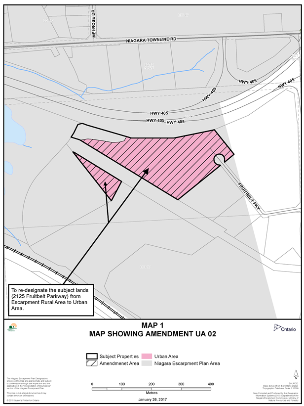
- UA02: Applicant: Cotton Holdings Inc. Location: 2125 Fruitbelt Parkway, Part of Lots 4, Geographic Township of Stamford, City of Niagara Falls, Regional Municipality of Niagara.
- The Niagara Escarpment Plan mapping is amended as shown on Map 1 to this Schedule.
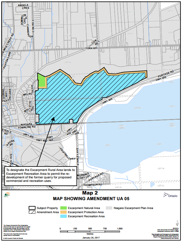
- UA05: Applicant: Queenston Quarry Reclamation Company. Location: 5523 Townline Road, Part of Lots 44, 45, 47, 48 and 49, Part of the Road allowance between Lots 44 and 49, Part of the Road allowance between lots 45 and 46, Part of the Road allowance between Lots 45 and 48, Part of the Road allowance between Lots 46 and 47 and Part of the Road allowance between Lots 47 and 48, Geographic Township of Niagara, Town of Niagara-on-the-Lake, Regional Municipality of Niagara.
- The Niagara Escarpment Plan mapping is amended as shown on Map 2 to this Schedule.
- Part 2.2.20 of the Niagara Escarpment Plan is deleted and replaced with the following special provision:
The Queenston Quarry lands, on Part of Lots 44, 45, 47, 48 and 49, Part of the Road allowance between Lots 44 and 49, Part of the Road allowance between lots 45 and 46, Part of the Road allowance between Lots 45 and 48, Part of the Road allowance between Lots 46 and 47 and Part of the Road allowance between Lots 47 and 48, Geographic Township of Niagara, in the Town of Niagara-on the-Lake, Regional Municipality of Niagara, are subject to the following provisions:- The lands will continue to be governed by the Mineral Resource Extraction Area policies of this Plan until such time as the Ministry of Natural Resources and Forestry is satisfied that rehabilitation is complete and the quarry licence is surrendered in accordance with the Aggregate Resources Act and the Ministry of the Environment and Climate Change confirms in writing that any required site remediation and decommissioning has been satisfactorily completed. Prior to surrender of the licence, site rehabilitation may be permitted to occur at the same time as, and consistent with the development of new uses which may be permitted provided they are in accordance with all other relevant policies of this Plan.
- The exact delineation of the Escarpment Natural Area designation on the lands is as shown on Map 2 to this Schedule.
- Notwithstanding the permitted uses of the Escarpment Protection Area, the portion of the lands designated Escarpment Protection Area may be used in association with a golf course for uses accessory to the design and operation of a golf course.
- Following the surrender of the quarry licence as referred to in a) above, all or part of the lands may be permitted to connect to municipal servicing subject to compliance with all other relevant policies of this Plan and the approval of such servicing by the Region of Niagara.
- The uses which may be permitted are those provided for on the lands in the Region of Niagara Official Plan Amendment No.1-2009 and the Town of Niagara-on-the-Lake Official Plan Amendment No. 45, as they may be amended from time to time.
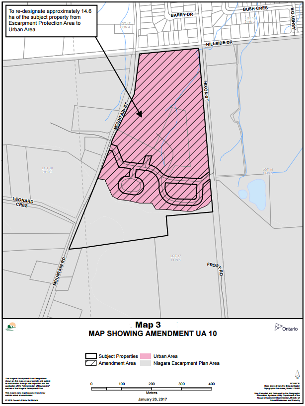
- UA10: Applicant: Albright Gardens Homes Inc. Location: 5050 Hillside Drive, Part of Lots 17 and 18, Concession 5, Geographic Township of Clinton, in the Town of Lincoln, Regional Municipality of Niagara.
- The Niagara Escarpment Plan mapping is amended as shown on Map 3 to this Schedule.
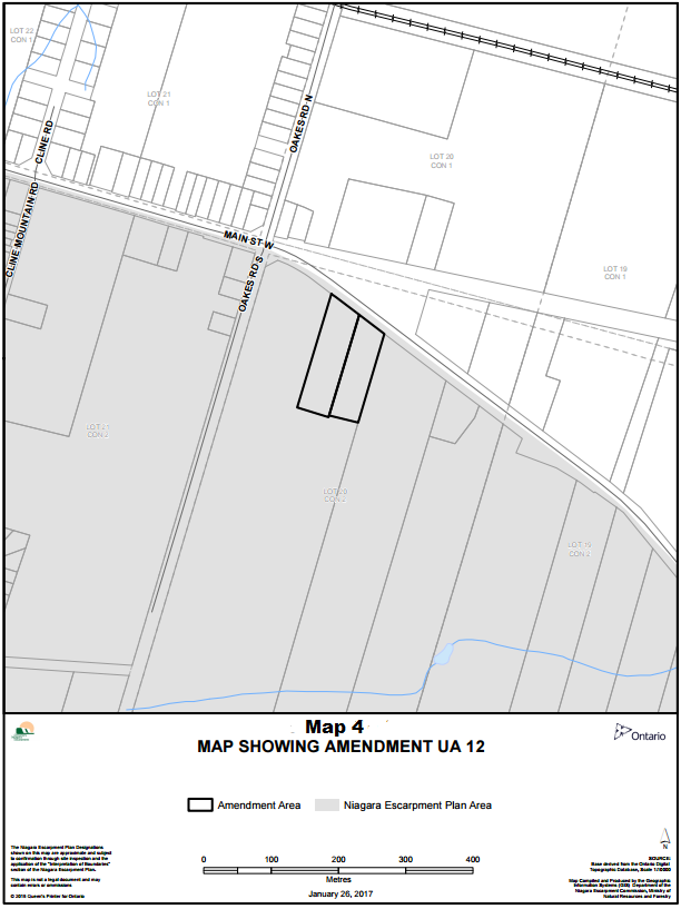
- UA12: Applicant: Winona Concrete and Pipe Products Ltd. Location: 487 & 489 Main Street West, Part of Lot 20, Concession 2, Geographic Township of Grimsby, in the Town of Grimsby, Regional Municipality of Niagara.
- The following new policy is added to Part 2.3 of the Niagara Escarpment Plan:
Notwithstanding Part 2.3.4, an existing industrial use located on Part Lot 20, Concession 2, Geographic Township of Grimsby, in the Town of Grimsby, Regional Municipality of Niagara may be permitted to expand within the area shown on Map 4 to this Schedule.
- The following new policy is added to Part 2.3 of the Niagara Escarpment Plan:
- UA16: Applicant: City of Hamilton. Location: 385 Jerseyville Road, Part of Lots 38 and 39, Concession 2, Geographic Township of Ancaster, in the City of Hamilton.
- The Niagara Escarpment Plan mapping is amended as shown on Map 5 to this Schedule.
- UA17: Applicant: IBI Group on behalf of Alyssa Cohen and Scott Friedman. Location: 42 Springhill Street, Part of Lots 10 & 11, Concession 1, Geographic Township of West Flamborough, in the City of Hamilton.
- The Niagara Escarpment Plan mapping is amended as shown on Map 6 to this Schedule.
- UA18: Applicant: City of Hamilton. Location: 40 and 70 Olympic Drive, Part Lots of 19, 20, and 21, Concession 1, Geographic Township of West Flamborough, in the City of Hamilton
- The Niagara Escarpment Plan mapping is amended as shown on Map 7 to this Schedule.
- UA19: Applicant: Janet Hopkins. Location: 296 York Road, Part of Lots 20 and 21, Concession 1, Geographic Township of West Flamborough, in the City of Hamilton.
- The following new policy is added to Part 2.12 of the Niagara Escarpment Plan:
Notwithstanding Part 2.12.7, a single detached dwelling located on Part of Lots 20 and 21, Concession 1, Geographic Township of West Flamborough (296 York Road) in the City of Hamilton may be permitted to connect to the municipal sewer system.
- The following new policy is added to Part 2.12 of the Niagara Escarpment Plan:
- UA22: Applicant: Denis and Cynthia Callaghan. Location: 768 Mountain Brow Road, Part of Lots 12 & 13, Concession 2, Geographic Township of East Flamborough, in the City of Burlington, Regional Municipality of Halton.
- The following new policy is added to Part 2.12 of the Niagara Escarpment Plan:
Notwithstanding Part 2.12.7, a single detached dwelling located at 768 Mountain Brow Road, Part of Lots 12 & 13, Concession 2, Geographic Township of East Flamborough, in the City of Burlington, Regional Municipality of Halton, may be permitted to connect to the municipal water service.
- The following new policy is added to Part 2.12 of the Niagara Escarpment Plan:
- UA41: Applicant: Cosmopolitan Associates Inc. Location: 3383 Guelph Line, Part of Lot 15, Concession 1 NDS, Geographic Township of Nelson, in the City of Burlington, Regional Municipality of Halton
- The following new policy is added to Part 2.3 of the Niagara Escarpment Plan:
Notwithstanding Part 2.3.4, up to a 1,300 square-metre building to be used as a funeral establishment and expansion of the existing area occupied by cemetery burial gardens may be permitted to be added to an existing use located on Part of Lot 15, Concession 1 NDS, Geographic Township of Nelson, in the City of Burlington, Regional Municipality of Halton.
- The following new policy is added to Part 2.3 of the Niagara Escarpment Plan:
- UA42: Applicant: Victor Petrovski. Location: 2373 Dundas Street, Part of Lot 17, Concession 1 NDS, Geographic Township of Nelson, in the City of Burlington, Regional Municipality of Halton.
- The following new policy is added to Part 1.4.3 of the Niagara Escarpment Plan:
Notwithstanding the Permitted Uses of this section, a commercial reception (banquet) and conference facility, with capacity up to a maximum of 150 guests, may be permitted, outside of the heritage portion of the “Springer House”, to replace the existing banquet / conference facility on Part of Lot 17, Concession 1 NDS, Geographic Township of Nelson, in the City of Burlington, Regional Municipality of Halton.
- The following new policy is added to Part 1.4.3 of the Niagara Escarpment Plan:
- UA45: Applicant: Town of Milton. Location: Part of Lots 14 & 15, Concession 1, Geographic Township of Trafalgar, in the Town of Milton, Regional Municipality of Halton.
- The following new policy is added to Part 2.12 of the Niagara Escarpment Plan:
Notwithstanding Part 2.12.7, a NEPOSS Park, on Part of Lots 14 and 15, Concession 1, Geographic Township of Trafalgar, in the Town of Milton, Regional Municipality of Halton, may be permitted to connect to municipal servicing. - The Niagara Escarpment Plan mapping is amended to add the NEPOSS overlay on the subject lands as shown on Map 8 to this Schedule.
- The following new policy is added to Part 2.12 of the Niagara Escarpment Plan:
- UA46: Applicant: Town of Milton. Location: Part of Lots 1 & 2, Concession 1, Geographic Township of Esquesing, and Part of Lots 1, 2 and 3, Concession 7, Geographic Township of Nassagaweya, in the Town of Milton, Regional Municipality of Halton.
- The following new policy is added to Part 2.12:
Notwithstanding Part 2.12.7, a NEPOSS Park, on Part of Lots 1 & 2, Concession 1, Geographic Township of Esquesing and Part of Lots 1, 2 and 3, Concession 7, Geographic Township of Nassagaweya, in the Town of Milton, Regional Municipality of Halton, may be permitted to connect to municipal servicing. - The Niagara Escarpment Plan mapping is amended to add the NEPOSS overlay on the subject lands as shown on Map 9 to this Schedule.
- The following new policy is added to Part 2.12:
- UA47: Applicant: Conservation Halton. Location: The Kelso Glen Eden Conservation Area located at 5234 Kelso Road, Part of Lots 4 and 5, Concession 6, and Part of Lots 1, 2, 3, 4, and 5, Concession 7 and Part of the Road allowance between Concessions 6 and 7, Geographic Township of Nassagaweya, in the Town of Milton, Regional Municipality of Halton.
- The following new policy is added to Part 2.12 of the Niagara Escarpment Plan:
Notwithstanding Part 2.12.7, an extension of municipal water and wastewater services may be permitted within Part Lots 4 and 5, Concession 6, and Part of Lots 1, 2, 3, 4, and 5, Concession 7, Geographic Township of Nassagaweya, in the Town of Milton, Regional Municipality of Halton to service park facilities within the Kelso Glen Eden Conservation Area.
- The following new policy is added to Part 2.12 of the Niagara Escarpment Plan:
- UA48: Applicant: Country Heritage Agricultural Society. Location: 8560 Tremaine Road, Part of Lots 4 and 5, Concession 7, Geographic Concession of Nassagaweya, in the Town of Milton, Regional Municipality of Halton.
- The following new policy is added to Part 2.12 of the Niagara Escarpment Plan:
Notwithstanding Part 2.12.7, Country Heritage Park, a NEPOSS Park, on Part of Lots 4 and 5, Concession 7, Geographic Township of Nassagaweya, in the Town of Milton, Regional Municipality of Halton, may be permitted to connect to municipal sewer servicing.
- The following new policy is added to Part 2.12 of the Niagara Escarpment Plan:
- UA49: Applicant: Nicholas H. Dell (agent) on behalf of Sanjay Massey. Location: 11445 Regional Road 25, Part of Lot 18, Concession 3, Geographic Township of Esquesing, in the Town of Halton Hills, Regional Municipality of Halton.
- The following new policy is added to Part 1.5.3 of the Niagara Escarpment Plan:
Notwithstanding the Permitted Uses of this Section, a non-profit, private elementary school use up to 1,800 square metres may be permitted in an existing vacant building located on Part Lot 18, Concession 3, Geographic Township of Esquesing, in the Town of Halton Hills, Regional Municipality of Halton.
- The following new policy is added to Part 1.5.3 of the Niagara Escarpment Plan:
- UA51: Applicant: Poltawa Country Club. Location: 55 Odessa Boulevard (Terra Cotta), Part of Lot 28, Concession 5 WHS, Part of Lot 27, Concession 6 WHS, Part of the Road allowance between Concessions 5 and 6 WHS and Part of the Road allowance between Lots 27 and 28, Geographic Township of Chinguacousy, in the Town of Caledon, Regional Municipality of Peel.
- The Niagara Escarpment Plan mapping is amended as shown on Map 10 to this Schedule.
- UA54: Applicant: Town of Caledon. Location: McColl Drive and 15825 and 15835 McLaughlin Rd, Part of Lot 3, Concession 1 WCR, Geographic Township of Caledon, in the Town of Caledon, Regional Municipality of Peel.
- The Niagara Escarpment Plan mapping is amended as shown on Map 11 to this Schedule.
- UA56: Applicant: Pine River Institute. Location: 606060 River Road, Part of Lots 12 & 13, Concession 3, West of Hurontario Street, Township of Mulmur, County of Dufferin.
- The following new policy is added to Part 2.3 of the Niagara Escarpment Plan:
Notwithstanding Part 2.3.4, a dormitory, up to 613 square metres, may be permitted to be added to an exsiting institutional use located on Part of Lots 12 &13, Concession 3, West of Hurontario Street, Geographic Township of Mulmur, County of Dufferin.
- The following new policy is added to Part 2.3 of the Niagara Escarpment Plan:
Schedule A: Map 1 - showing amendment ua 02
View a larger version of this map (PDF)
To re-designate the subject lands (2125 Fruitbelt Parkway) from Escarpment Rural Area to Urban Area.
The Niagara Escarpment Plan Designations shown on this map are approximate and subject to confirmation through site inspection and the application of the ”Interpretation of Boundaries” section of the Niagara Escarpment Plan.
This map is not a legal document and may contain errors or ommissions.
Source: Base derived from the Ontario Digital Topographic Database, scale 1:10000.
Map Compiled and Produced by the Geographic Information Systems (GIS) Department of Niagara Escarpment Commission, Ministry of Natural Resources and Forestry
Schedule A: Map 2 - showing amendment ua 056
View a larger version of this map (PDF)
To designate the Escarpment Rural Area lands to Escarpment Recreation Area to permit the redevelopment of the former quarry for proposed commercial and recreation uses.
The Niagara Escarpment Plan Designations shown on this map are approximate and subject to confirmation through site inspection and the application of the "Interpretation of Boundaries" section of the Niagara Escarpment Plan.
This map is not a legal document and may contain errors or ommissions
SOURCE: Base derived from the Ontario Digital Topographic Database, Scale 1:10000
Map Compiled and Produced by the Geographic Information Systems (GIS) Department of the Niagara Escarpment Commission, Ministry of Natural Resources and Forestry
Schedule A: Map 3 - showing amendment ua 10
View a larger version of this map (PDF)
To re-designate approximately 14.6 ha of the subject property from Escarpment Protection Area to Urban Area.
The Niagara Escarpment Plan Designations shown on this map are approximate and subject to confirmation through site inspection and the application of the "Interpretation of Boundaries" section of the Niagara Escarpment Plan.
This map is not a legal document and may contain errors or ommissions
SOURCE: Base derived from the Ontario Digital Topographic Database, Scale 1:10000
Map Compiled and Produced by the Geographic Information Systems (GIS) Department of the Niagara Escarpment Commission, Ministry of Natural Resources and Forestry
Schedule A: Map 4 - showing amendment ua 12
View a larger version of this map (PDF)
The Niagara Escarpment Plan Designations shown on this map are approximate and subject to confirmation through site inspection and the application of the "Interpretation of Boundaries" section of the Niagara Escarpment Plan.
This map is not a legal document and may contain errors or ommissions
SOURCE: Base derived from the Ontario Digital Topographic Database, Scale 1:10000
Map Compiled and Produced by the Geographic Information Systems (GIS) Department of the Niagara Escarpment Commission, Ministry of Natural Resources and Forestry
Schedule A: Map 5 - showing amendment ua 16
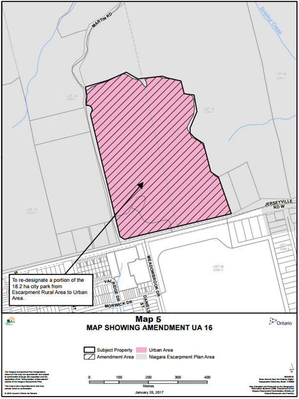
View a larger version of this map (PDF)
To re-designate a portion of the 18.2 ha city park from Escarpment Rural Area to Urban Area.
The Niagara Escarpment Plan Designations shown on this map are approximate and subjectto confirmation through site inspection and the application of the "Interpretation of Boundaries" section of the Niagara Escarpment Plan.
This map is not a legal document and may contain errors or ommissions
SOURCE: Base derived from the Ontario Digital Topographic Database, Scale 1:10000
Map Compiled and Produced by the Geographic Information Systems (GIS) Department of the Niagara Escarpment Commission, Ministry of Natural Resources and Forestry
Schedule A: Map 6 - showing amendment ua 17
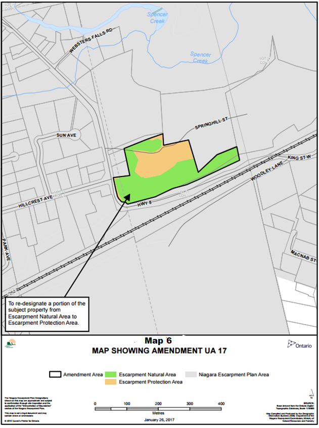
View a larger version of this map (PDF)
To re-designate a portion of the subject property from Escarpment Natural Area to Escarpment Protection Area
The Niagara Escarpment Plan Designations shown on this map are approximate and subject to confirmation through site inspection and the application of the "Interpretation of Boundaries" section of the Niagara Escarpment Plan.
This map is not a legal document and may contain errors or ommissions
SOURCE: Base derived from the Ontario Digital Topographic Database, Scale 1:10000
Map Compiled and Produced by the Geographic Information Systems (GIS) Department of the Niagara Escarpment Commission, Ministry of Natural Resources and Forestry
Schedule A: Map 7 - showing amendment ua 18
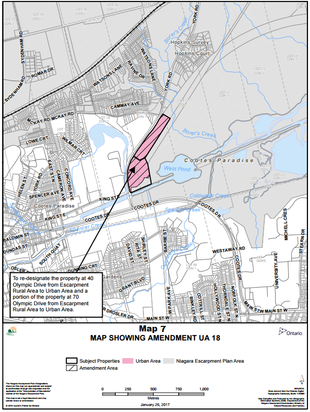
View a larger version of this map (PDF)
To re-designate the property at 40 Olympic Drive from Escarpment Rural Area to Urban Area and a portion of the property at 70 Olympic Drive from Escarpment Rural Area to Urban Area
The Niagara Escarpment Plan Designations shown on this map are approximate and subject to confirmation through site inspection and the application of the "Interpretation of Boundaries" section of the Niagara Escarpment Plan.
This map is not a legal document and may contain errors or ommissions
SOURCE: Base derived from the Ontario Digital Topographic Database, Scale 1:10000
Map Compiled and Produced by the Geographic Information Systems (GIS) Department of the Niagara Escarpment Commission, Ministry of Natural Resources and Forestry
Schedule A: Map 8 - showing amendment ua 45
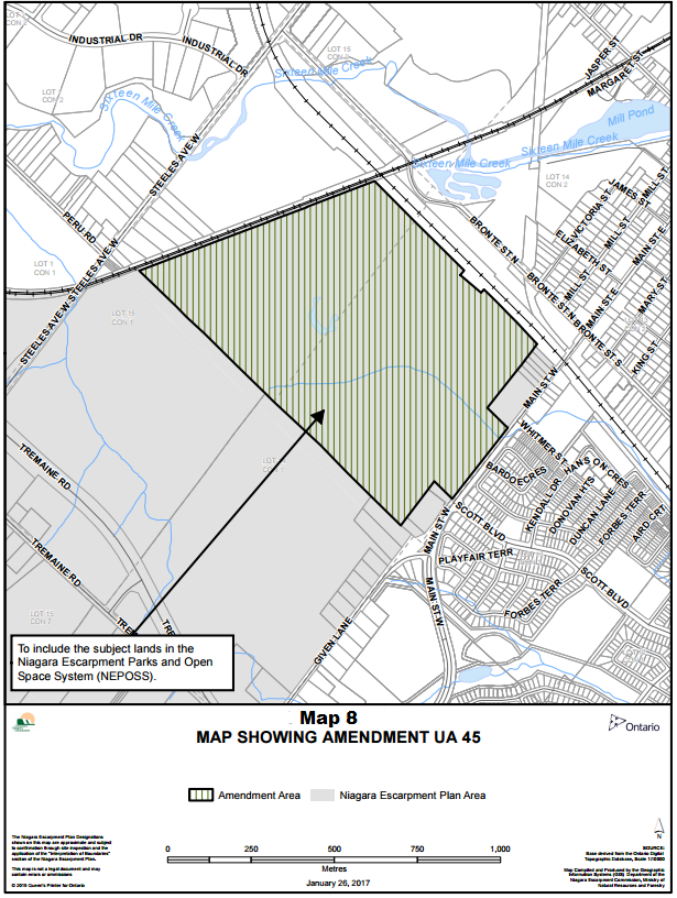
View a larger version of this map (PDF)
To include the subject lands in the Niagara Escarpment Parks and Open Space System (NEPOSS)
The Niagara Escarpment Plan Designations shown on this map are approximate and subject to confirmation through site inspection and the application of the "Interpretation of Boundaries" section of the Niagara Escarpment Plan.
This map is not a legal document and may contain errors or ommissions
SOURCE: Base derived from the Ontario Digital Topographic Database, Scale 1:10000
Map Compiled and Produced by the Geographic Information Systems (GIS) Department of the Niagara Escarpment Commission, Ministry of Natural Resources and Forestry
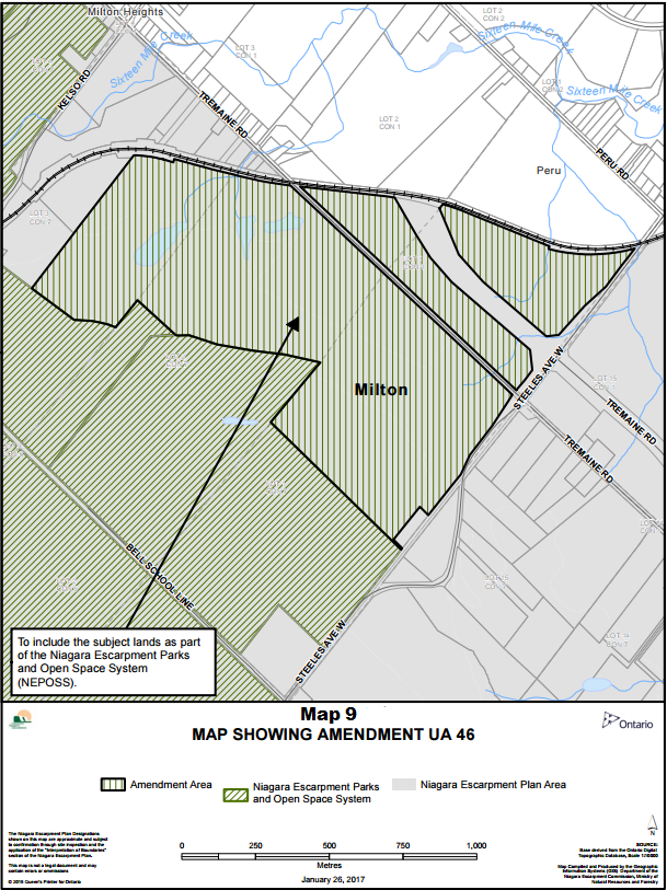
Schedule A: Map 9 - showing amendment ua 46
View a larger version of this map (PDF)
To include the subject lands of the Niagara Escarpment Parks and Open Space System (NEPOSS)
The Niagara Escarpment Plan Designations shown on this map are approximate and subject to confirmation through site inspection and the application of the "Interpretation of Boundaries" section of the Niagara Escarpment Plan.
This map is not a legal document and may contain errors or ommissions
SOURCE: Base derived from the Ontario Digital Topographic Database, Scale 1:10000
Map Compiled and Produced by the Geographic Information Systems (GIS) Department of the Niagara Escarpment Commission, Ministry of Natural Resources and Forestry
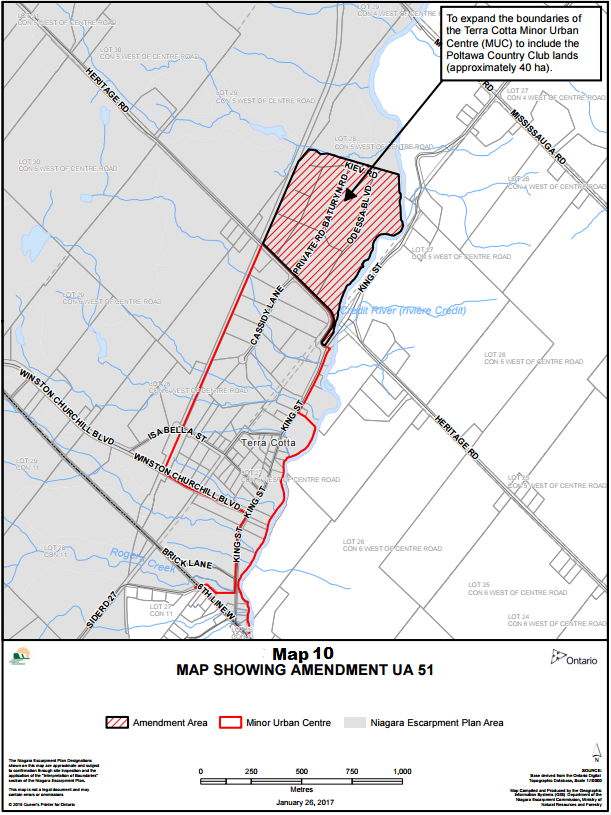
Schedule A: Map 10 - showing amendment ua 51
View a larger version of this map (PDF)
To expand the boundaries of the Terra Cotta Minor Urban Centre (MUC) to include the Poltawa Country Club lands (approximately 40 ha)
The Niagara Escarpment Plan Designations shown on this map are approximate and subject to confirmation through site inspection and the application of the "Interpretation of Boundaries" section of the Niagara Escarpment Plan.
This map is not a legal document and may contain errors or ommissions
SOURCE: Base derived from the Ontario Digital Topographic Database, Scale 1:10000
Map Compiled and Produced by the Geographic Information Systems (GIS) Department of the Niagara Escarpment Commission, Ministry of Natural Resources and Forestry
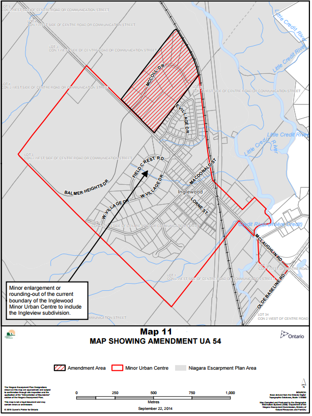
Schedule A: Map 11 - showing amendment ua 54
View a larger version of this map (PDF)
Minor enlargement or rounding-out of the current boundary of the Inglewood Minor Urban Centre to include the Ingleview subdivision.
The Niagara Escarpment Plan Designations shown on this map are approximate and subject to confirmation through site inspection and the application of the "Interpretation of Boundaries" section of the Niagara Escarpment Plan.
This map is not a legal document and may contain errors or ommissions
SOURCE: Base derived from the Ontario Digital Topographic Database, Scale 1:10000
Map Compiled and Produced by the Geographic Information Systems (GIS) Department of the Niagara Escarpment Commission, Ministry of Natural Resources and Forestry