Thermal inversions and spray drift
Learn about thermal inversions and how they can impact your spraying.
In April 2014, NDSU extension published an excellent factsheet explaining what thermal inversions are, how to detect them and how they affect pesticide spray drift. This article attempts to summarize the key points, but it is recommended that spray operators read the NDSU fact sheet.
The atmosphere
The earth is surrounded by a bubble of air called the atmosphere, and while you can't see it, imagine it as a bubbling, swirling mass that moves like water. The lower part of the earth's atmosphere (the surface boundary layer) is directly influenced by the earth's surface and everything on it (Figure 1). As it drags and percolates over the surface, it experiences relatively rapid changes in windspeed, temperature and humidity (on a time scale of an hour or less).
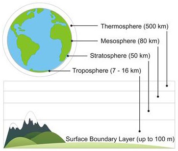
Accessible image description of Figure 1
Atmospheric temperature
Dry air naturally cools with elevation, at a rate of about 1°C per 100 m. This change, called the Adiabatic Lapse Rate is caused by pressure changes with elevation. As we move up, the weight of the overhead atmosphere decreases, pressure drops, and air expands. That expansion takes work, and that creates the cooling effect (see red line, Figure 2). See how simple thermodynamics are?
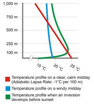
Accessible image description of Figure 2
When we add the effect of daytime solar heating and night time cooling, the rate of this temperature change is affected, and this changes how airborne particles like spray droplets settle, flow, and disperse.
Let's consider a clear, relatively calm day:
Early morning
On a clear, relatively calm morning, the sun emits short wave radiation, which is absorbed by the earth's surface. The surface conducts some of this energy deeper into the ground as well as heating the air near the surface. This creates a temperature gradient wherein the surface is warmest, and the air gets cooler with elevation (see red line, Figure 2).
As the air warms and expands, it becomes less dense and rises, similar to a lava lamp or hot air balloon (see Figure 3). As it rises, cooler air sinks and the air begins to circulate in a Convection Cell. This is called Thermal Turbulence, and is a very effective way for airborne particles, such as pesticide spray, to be rapidly diluted. This is also how the atmosphere disperses pollution.
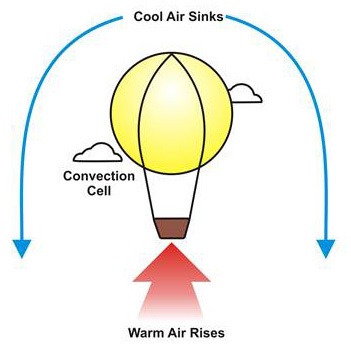
Accessible image description of Figure 3
If the morning were overcast instead of clear, the clouds would intercept much of the sun's radiation, absorbing or reflecting it. As a result, the earth's surface would still warm up, but much more slowly. Thermal turbulence would be suppressed.
Mid-late afternoon
As the sun passes over and the wind starts to rise, the convection cells get disrupted by the wind and experience mechanical turbulence (see blue line, Figure 2). This type of turbulence mixes warmer air near the ground with cooler air above it, and also suppresses thermal turbulence.
Mid-afternoon to night
As the energy from the sun lessens, the soil begins to cool, which in turn cools the air next to it. Once the air cools enough to be colder than the air above it, we have the beginning of a Temperature Inversion (see green line, Figure 1). It is called that because it is now the reverse of the typical day-time temperature profile. The height of the inversion grows with time, reaching a maximum of about 100 m by sunrise. Within the inversion layer, thermal turbulence no longer exists.
How inversions affect dispersion
We now know that during a sunny day, solar energy warms the earth's surface, and the air near the surface, more than air above it (see red line, Figure 2). We also know that this causes convection cells to circulate (Figure 3). The rising parcel of air will cool and shrink as it rises through the relatively cooler air above it. Conversely, cool parcels of air fall feely through warm air, and the resulting mixing action allows airborne particles (such as pollution or pesticide spray) to become much less potent at ground level. This protects us from drift damage (see Figure 4).
Accessible image description of Figure 4
Now let's imagine an air parcel that is displaced upward during an inversion. This time it is cooler than the air above it, and as it begins to rise it gets denser. This prevents it from rising, and it will return to the layer where started. In other words, it stays where it is. It is the same for a sinking parcel of air: it will start off warmer (and less dense) than the air below it, but will warm further as it falls. As a result, it will want to rise back to its origin.
The result is that in an inversion, air does not mix by thermal turbulence. Spray drift (or vapour) stays concentrated in the cold air into which it was released. And cold, dense air tends to move downhill or laterally with light winds, taking any spray drift particles with it.
How clouds and wind affect inversions
As mentioned earlier, clouds absorb energy from the sun as well as the long-wave radiation from the earth's surface. They also reflect radiation from the earth back to the soil. This is why overcast nights are warmer than clear ones.
Inversions are not affected by light wind (for example, 6 to 8 km/h), but as the wind increases and mechanical turbulence mixes the air, the strength of the inversion will be reduced and the atmosphere will approach a neutral condition (see blue line, Figure 2). There may not be an inversion, but spraying would still be inadvisable if the wind got too high.
Therefore, extended periods of mostly clear skies in the evening or night when the wind is light means a high probability of strong temperature inversions. Conversely, cloud cover usually means a near neutral atmosphere, so no strong inversion.
Humidity affects inversions
Inversions form more rapidly when there is less water vapour in the air to absorb radiation. Once humid air has cooled to the dew point, water condensation gives off energy and warms the air a little. This slows the formation of the inversion. Be aware that inversion conditions can exist long before fog forms, so fog is not a good indicator for the beginning of an inversion - you're already in one.
Soil conditions and shade affect inversions
This is a complex issue, but soil conditions that make inversions more intense include low soil moisture, freshly tilled soils, coarse soils, heavy residue and closed crop canopies. Further, inversions in shaded areas (for example, behind windbreaks) start sooner, and last longer. See the NDSU factsheet for more detail.
Inversions and spray drift
When you spray during an inversion, the larger drops fall quickly, but smaller lighter droplets fall very slowly (a few centimetres per second). The do not disperse (as in Figure 4). Instead, they float along with the cool air, evaporating very slowly, over great distances (see figure 5). These small particles, as well as vapours from volatilizing products, are capable of moving for kilometers.
Accessible image description of Figure 5
Spray timing
Inversions, once formed, persist until the sun rises and warms the earth's surface, or until winds increase and mix the stationary layers of air together. Therefore, spraying in the evening poses the greatest risk for pesticide drift when conditions favour inversions. Very early mornings (for example, around sunrise) are not much better. Remember, at sunrise, the inversion will be at its maximum height.
The rising sun will warm the earth and create turbulent conditions near its surface (for example, a few metres). It takes a few hours of sun for the inversion to burn off to a sufficient height to adequately disperse once again. Most inversions will have dissipated two hours after sunrise, which may be the best choice for spraying.
Detecting an inversion
The only sure way to know if you are in an inversion is to take two temperature readings: the first about 10 cm from the ground, and the second about three metres off the ground. If the surface temperature is cooler, you are in an inversion. The magnitude of the difference indicates how strong the inversion is. Accurate measurements are difficult to manage with conventional thermometers, so it is generally easier for sprayer operators to watch for the following cues:
- Large temperature swings between daytime and the previous night.
- Calm (for example, less than 3 km/h wind) and clear conditions,
- Intense high pressure systems and low humidity where you intend to spray
- Dew or frost (fog may be too late)
- Smoke or dust hanging in the air or moving laterally,
- Odours traveling large distances and seeming more intense,
- Daytime cumulus clouds collapse toward the evening
- Overnight cloud cover is 25% or less
If you suspect a strong inversion, don't spray. Stop drift before it starts.
Accessible image descriptions
Figure 1. The earth's atmosphere.
This illustration depicts the earth's atmosphere and concentric layers that comprise it. The outer-most layer is the thermosphere, spanning 80 to 500 km from the erth's surface. Moving inward, the next layer is the mesosphere, spanning 50- to 80 km from the earth's surface. Then the stratosphere, spanning approximately 10 to 50 km from the earth's surface. Finally, the innermost layer is the troposphere reaching some 10 km from the earth's surface. When discussing surface inversions, we generally focus on subsection of the Troposphere: the surface boundary layer, which is in constant flux, but generally spans the first 100 metres form the earth's surface.
Figure 2. Three possible atmospheric temperature profiles in the lower troposphere.
This graph depicts three possible atmospheric temperature profiles in the lower troposphere. The Y-axis represents elevation in metres and the X-axis represents temperature in celsius. The first profile is the air temperature on a clear, calm midday. The adiabatic lapse rate is minus one degree celsius per 100 metre elevation, and is graphed as a positively-skewed line from 25 degrees celsius at the earth's surface. The second profile is the air temperature on a windy midday. In this case, the slope of the slight asymptote is near-vertical, beginning at 19 degrees celsius and curving slightly to 18 degrees celsius at 1000 metres, where it approaches linearity. The third and final profile is the air temperature during a surface inversion before sunset. This sinusoidal curve starts at 15 degrees at the earth's surface, reaching 24 degrees at the 100 metre elevation, before cooling again at a shallow angle to 22 degrees celsius at a 1000 metre elevation.
Figure 3. A hot-air balloon is a metaphor for convection cells that create thermal turbulence.
This illustration is a metaphor for how convection cells circulate. A hot air balloon is depicted to represent light, warm rising air, displacing cooler, denser air which falls around it. The result of a circulation cell is thermal turbulence.
Figure 4. Thermal turbulence allows particle-laden warm air to rise and clean cool air to fall.
This illustration shows how particle-laden warm air rises and thereby removes airborne pesticide, dust and pollution from the lower troposphere. Concurrently, cooler, denser clean air falls to replace it. It is in this manner that thermal turbulence disperses air-borne particles.
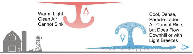
Figure 5. Thermal turbulence is suppressed during a temperature inversion.
This illustration shows how a thermal inversion suppresses thermal turbulence. In this case, the particle-laden air is cooler than the air above it, and convection cannot occur. This relatively warmer layer of air cannot rise, but does move laterally with light winds and downhill. This is how pesticide can drift in an inversion.