Oak Ridges Moraine maps
Read about the Oak Ridges Moraine Conservation Plan and view maps of the moraine’s boundary, and ecological and hydrological features.
Overview
The Oak Ridges Moraine Conservation Plan was established in 2002. It provides direction on land use and resource management for the land and water located within the moraine.
As part of the Greenbelt, the Oak Ridges Moraine is an environmentally sensitive, geological landform in south central Ontario that stretches 160 kilometers from the Trent River in the east to the Niagara Escarpment in the west, covering approximately 470,000 acres.
The Oak Ridges Moraine Conservation Act, 2001 designates the Oak Ridges Moraine Area and provides the authority for the creation of the Oak Ridges Moraine Conservation Plan for that Area. On December 6, 2023 section 2 of the Act was re-enacted to designate the Oak Ridges Moraine Area based on the series of land designation maps. The act requires that decisions made under the Planning Act and the Condominium Act, 1998 conform with the Oak Ridges Moraine Conservation Plan.
Current land use designation maps (2023)
The Oak Ridges Moraine Conservation Plan shows the land use designations including Natural Core Areas, Natural Linkage Areas, Countryside Areas and Settlement Areas as defined by the Oak Ridges Moraine Conservation Plan and reflecting the statutory reversal of the 2022 amendment by section 26 of the Oak Ridges Moraine Conservation Act, 2001:
- Map 321 (as filed in the Provincial Land Use Plans Branch, MMAH)
View detailed maps (sectional maps) showing the land use designation map divided into smaller geographic areas:
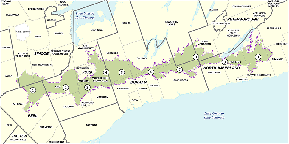
Image description: Map of the Oak Ridges Moraine conservation area divided into 10 municipal sections covered by the maps below.
- Section 1 - Caledon, Adjala-Tosorontio, Mono, New Tecumseth (PDF)
- Section 2 - Township of King (PDF)
- Section 3 - Aurora, Newmarket, Richmond Hill, Vaughan (PDF)
- Section 4 - East Gwillimbury, Markham, Whitchurch-Stouffville (PDF)
- Section 5 - Pickering, Uxbridge (PDF)
- Section 6 - Oshawa, Scugog, Whitby (PDF)
- Section 7 - Clarington (PDF)
- Section 8 - Cavan-Millbrook-North Monaghan, City of Kawartha Lakes (PDF)
- Section 9 - Hamilton, Port Hope (PDF)
- Section 10 - Alnwick-Haldimand, Cramahe, Trent Hills (PDF)
Current land use designation interactive map (2023)
Boundary regulation maps (2002)
The Oak Ridges Moraine Area is precisely defined in section 2 of the Oak Ridges Moraine Conservation Act, 2001 and described on a series of maps.
This map series provides the information for establishing the Oak Ridges Moraine by a Licensed Ontario Land Surveyor, under instructions from the Surveyor General for the Province of Ontario including changes made in 2017. The following maps should be read in conjunction with section 2 of the Oak Ridges Moraine Conservation Act, 2001.
The Oak Ridges Moraine Area (2002)
These maps show the prescribed legal boundary of the Oak Ridges Moraine.
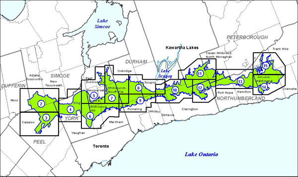
Image description: Map of the Oak Ridges Moraine conservation area divided into 18 sections covered by the maps or sheets below.
These map sheets are digital representations of the official signed versions of the Plan of the boundary of the Oak Ridges Moraine Area, which are available through the Office of the Surveyor General.
- Sheet 1 of 18 (PDF) - Full scale key map for the plan of the boundary of the Oak Ridges Moraine showing the plan area separated into 18 tiles
- Sheet 2 of 18 (PDF) - Adjala-Tosorontio, Caledon, Mono, New Tecumseth, Township of King
- Sheet 3 of 18 (PDF) - Caledon, Township of King
- Sheet 4 of 18 (PDF) - Township of King
- Sheet 5 of 18 (PDF) - Aurora, Newmarket, Richmond Hill, East Gwillimbury, Township of King, Whitchurch-Stouffville
- Sheet 6 of 18 (PDF) - Aurora, Richmond Hill, Vaughan, Markham, Township of King, Whitchurch-Stouffville
- Sheet 7 of 18 (PDF) - East Gwillimbury, Pickering, Uxbridge, Whitchurch-Stouffville
- Sheet 8 of 18 (PDF) - Clarington, Oshawa, Uxbridge, Scugog, Whitby
- Sheet 9 of 18 (PDF) - Markham, Oshawa, Pickering, Scugog, Uxbridge, Whitby, Whitchurch-Stouffville
- Sheet 10 of 18 (PDF) - City of Kawartha Lakes, Clarington, Oshawa, Scugog, Whitby
- Sheet 11 of 18 (PDF) - City of Kawartha Lakes, Scugog, Cavan-Millbrook-North Monaghan
- Sheet 12 of 18 (PDF) - City of Kawartha Lakes, Clarington, Port Hope, Cavan-Millbrook-North Monaghan
- Sheet 13 of 18 (PDF) - Alnwick-Haldimand, Cavan-Millbrook-North Monaghan, Hamilton, Port Hope
- Sheet 14 of 18 (PDF) - Alnwick-Haldimand, Cramahe, Hamilton
- Sheet 15 of 18 (PDF) - Alnwick-Haldimand, Cramahe, Hamilton, Trent Hills
- Sheets 16 to 18 (PDF) - UTM coordinates required for surveying the Oak Ridges Moraine Area
Removal from the Oak Ridges Moraine Area (2017)
This map shows the prescribed legal boundary of the removal from the Oak Ridges Moraine Area in 2017.
Landform conservation areas maps (2002)
The Oak Ridges Moraine contains many landform types that affect the ecological and hydrological character of the moraine.
These maps show landform conservation areas such as natural and water-based features within the Oak Ridges Moraine

Image description: Map of the Oak Ridges Moraine conservation area divided into 4 sections to show the ecological and hydrological character of the areas covered by the maps below.
- Section 1 (PDF) - Peel Region, County of Simcoe and County of Dufferin
- Section 2 (PDF) - York Region and Durham Region
- Section 3 (PDF) - Durham Region, City of Kawartha Lakes and City of Peterborough
- Section 4 (PDF) - City of Peterborough and County of Northumberland
Areas of high aquifer vulnerability maps (2002)
These regional maps show areas within the Oak Ridges Moraine where aquifers are highly vulnerable to contamination from both human and natural sources.
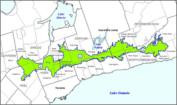
Image description: Map of the Oak Ridges Moraine conservation area divided into 3 sections by regional boundaries to show the ecological and hydrological character of the areas covered by the maps below.
- Section 1 (PDF) - York Region and Peel Region
- Section 2 (PDF) - Durham Region
- Section 3 (PDF) - Durham Region, City of Peterborough, and County of Northumberland
Sectional maps
View detailed maps showing part of the Oak Ridges Moraine area and areas of high aquifer vulnerability by municipal boundaries.
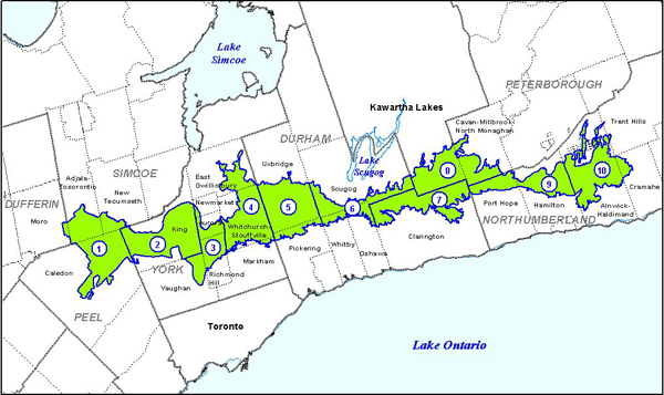
Image description: Map of the Oak Ridges Moraine conservation area divided into 10 sections by municipal boundaries to show the ecological and hydrological character of the areas covered by the maps below.
- Section 1 - Caledon, Adjala-Tosorontio, Mono, New Tecumseth (PDF)
- Section 2 - Township of King (PDF)
- Section 3 - Aurora, Newmarket, Richmond Hill, Vaughan (PDF)
- Section 4 - East Gwillimbury, Markham, Whitchurch-Stouffville (PDF)
- Section 5 - Pickering, Uxbridge (PDF)
- Section 6 - Oshawa, Scugog, Whitby (PDF)
- Section 7 - Clarington (PDF)
- Section 8 - Cavan-Millbrook-North Monaghan, City of Kawartha Lakes (PDF)
- Section 9 - Hamilton, Port Hope (PDF)
- Section 10 - Alnwick-Haldimand, Cramahe, Trent Hills (PDF)
Open data (2002-2023)
Get GIS data of the Oak Ridges Moraine land use designations, regulatory boundaries and landform conservation areas:
Active offer of assistance
If you require this information in an alternative format or need assistance using our interactive maps, please contact mininfo@ontario.ca. We will:
- acknowledge your request within three business days
- let you know when we are able to fulfil the request