This page is no longer current and is provided for archival and research purposes.
Forest Resources of Ontario 2016
Learn more about Ontario forests and forest resources. Find statistics describing the area of land and water forest types and the distribution of tree species across Ontario summarized in tables, charts and colour maps.
Foreword
“The Forest Resources of Ontario” (FRO) has been produced since the 1920s. Each version of the FRO builds on the previous in response to improved information and user feedback. This version continues to respond to the questions received about Ontario’s forests. The accuracy of FRO 2016 has been enhanced by the volume of spatial data being compiled and refined across the MNRF on a daily basis.
The Crown Forests and Lands Policy Branch notes the contribution of MNRF district and Regional staff and forest industry partners for providing forest resources and annual report information. The remote sensing staff in Peterborough for providing satellite (land cover) imagery for provincial summaries. As well, the staff at Land Information Ontario (LIO) have been instrumental in providing invaluable access to the most up to date provincial level data layers.
Ontario’s forests
Canada occupies over 998 million hectares of the earth’s surface and includes more than 400 million hectares of forests. This represents about 6% of the world’s forests. Ontario has over 71 million hectares of forest – 2% of the world’s forests and 17% of Canada’s forests. There are 10 hectares of land and water for every citizen of the province. There are 6.5 hectares of forest for every Ontarian.
Ontario’s 71 million hectares of forest cover a land area equivalent in size to the landmasses of Germany, Italy and the Netherlands combined. Ontario has 56 million hectares of productive forest covering an area roughly equivalent to the area of France.
Ontario’s landscape is dominated by forests, lakes and wetlands. Most Ontarians are very familiar with the southern portions of the province which contain a mixture of small patches of forest, agricultural lands and urban areas. In reality, that image of Ontario represents only about 7% of the province. The rest of Ontario is dominated by vast tracts of forest.
Map of Ontario’s geological foundation
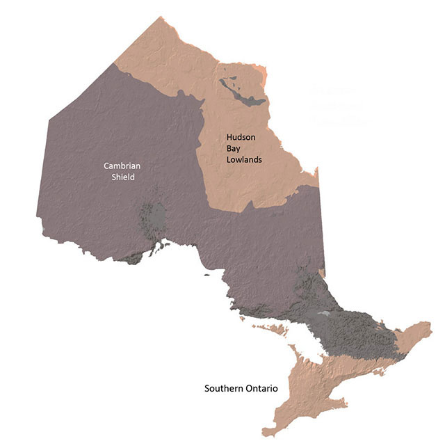
Enlarge Map of Ontario’s geological foundation
A base for forests –Geology and climate
Ontario lies on a foundation of bedrock and sedimentary rock that are among the oldest in the world. The Cambrian Shield (often referred to as the Canadian Shield) is dominated by shallow soils and granite bedrock that stretch from the northern end of the Great-Lakes through to the Hudson Bay Lowlands. The Cambrian Shield accounts for 66% of Ontario’s area and contains approximately 86% of Ontario’s productive forests.
North and south of the Cambrian Shield lay areas of carbonate or limestone sedimentary rock formed over 438 million years ago. The Hudson Bay Lowlands north have strong influences of climate and organic soil cover that limit forests to mostly slow growing Black Spruce. Southern Ontario is a highly productive area is now dominated by agriculture and urban settlement.
Approximately 12,000 years ago, the last major glacial advance – the Laurentide ice sheet –extended in several major lobes across Ontario. The retreating ice sheet deposited materials of many types. The most common material deposited was till, or mixture of unsorted and unstratified clay, silt, sand gravel and boulders. Fluvial and lacustrine features were deposited by water (river or lake). Organic deposits are areas of very deep peat or sphagnum.
Soils are an important factor affecting tree species distribution and growth. Each tree species in Ontario has site specific soil requirements. The relationship between forest soils, climate and forest vegetation is known to be important to forest management. Since 1999, the MNRF has been photo interpreting broad forest ecosystem classification (FEC) types along with stands of trees in the forest resources inventory (FRI). Soil depth, texture and moisture class are key characteristics in identifying ecosystem types. Ecosystem type is a further refinement/classification of stand level forest inventories.
Climate influences Ontario’s forests in a complex pattern. The interaction of climatic factors and soil characteristics has dramatic impact on the tree species found in any given area. Ontario’s climate is most affected by cold polar air from Hudson Bay and the prairies, and warmer air from the Gulf of Mexico. The Great Lakes also have a profound influence on Ontario’s weather.
Quaternary geology
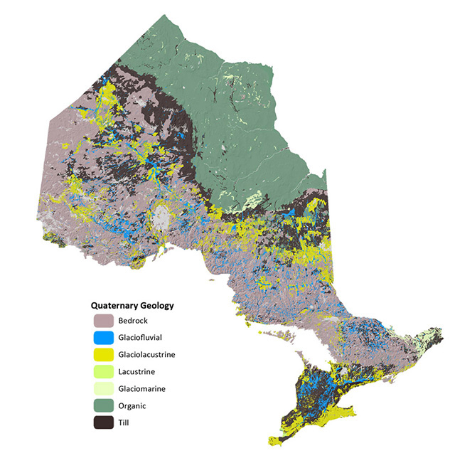
Enlarge Map of Ontario’s geological foundation
Forest management area
The area in Ontario where forest management occurs is referred to as the “Area of the Undertaking” (MNR-71) or AOU. It is an area that was delineated in the Class Environmental Assessment for forest management in 1994. The details of the EA are available on the MNRF website Ontario.ca. The Whitefeather Forest (MNR-74) was been added to the AOU in this report.
Prior to 2001, the FRO series reported Ontario’s total area as 106.8 million hectares. In 2001, that area was revised to 107.6 million hectares. Ontario did not increased in size, rather the way we measure it changed.
Improvements in mapping technology and geographic information systems continue to refine the actual measurements we derive from our landbase. For the purposes of this report, Ontario’s total area is 107,520,421 hectares, which is slightly lower than the 2011 reported total.
Geographic projections
Due to curvature of the Earth, any paper or flat map distorts the Earth’s surface. The larger the area represented by a map, the greater the distortion can be. Ontario covers a very large area, and is over 1,500 kilometres north to south and east to west. A map projection is a way to portray geographic data on a flat surface. Many types of projections are in use today, and each has its own advantages and disadvantages. Information used in this report comes from several different map projections. Most of Ontario’s digital FRI data is developed in the Universal Transverse Mercator Projection (UTM). Since this crosses multiple zones and can be difficult to work with as a continuous coverage, all of the data used in this report has been moved to the Lambert Conformal Conic Projection (NAD83) for consistency and ease of use.
It is important to note that many of the pieces used to compile this report originated from varying scales, accuracies, vintages and sources. All attempts have been made to ensure that the data layers line up correctly with minimal errors or overlap. As well, class or data definitions between data sources can vary, and not all data elements line up exactly.
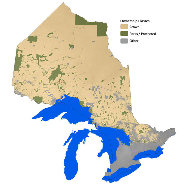
Ownership classes
The ownership groups used in this report are:
- Crown: this represents publically owned forest. Land withdrawals normally associated with areas of concern (AOCs), areas of scientific and natural interest (ANSIs), protection forest and other planning concerns are included in this classification.
- Parks and protected areas: areas of forest/land within all provincial and federal parks, recreation reserves and conservation reserves, both proposed and existing. The utilization zone of Algonquin Park is excluded (classed as Crown Land).
- Other: Areas of land within federal, private or First Nations ownership.
Map of ownership classes