This page is no longer current and is provided for archival and research purposes.
Management zones
Management zones
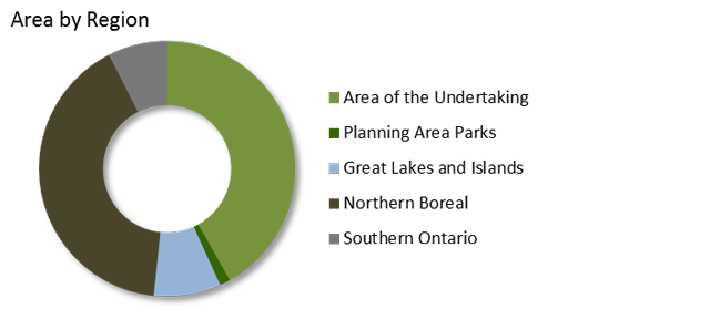
Ontario is divided into several management zones for the purposes of administration and management programs. The Area of the Undertaking is one of these zones and is described in detail. The northern boreal or far north is essentially all land north of the AOU and is largely inaccessible with some isolated communities scattered across the landscape. The planning area parks are part of Ontario’s Living Legacy and was coupled with the AOU as part of a planning program in the late 1990s designed to expand parks and protected areas within the managed forest. The great lakes zone is a summary of the lakes themselves, and the islands that occur within them, including Manitoulin. Southern Ontario is where most of the population in the province lives, and is dominated by private land.
Total area by land class and administrative zone (hectares)
| Land class | Area of the Undertaking | Planning Area Parks | Great Lakes and Islands | Northern Boreal | Southern Ontario |
|---|---|---|---|---|---|
| Water | 5,864,260 | 248,795 | 8,725,395 | 4,224,622 | 372,406 |
| Wetland | 467,734 | 8,419 | 3,838 | 8,861,162 | 136,235 |
| Field/Agriculture | 595,793 | 22 | 59,169 | 12 | 4,746,538 |
| Other | 656,638 | 61,768 | 47,548 | 685,299 | 689,218 |
| Treed Wetland | 1,776,527 | 47,453 | 3,836 | 12,283,354 | 860,777 |
| Forest | 35,618,055 | 1,091,381 | 264,078 | 17,921,211 | 1,198,878 |
| Total Area | 44,979,007 | 1,457,837 | 9,103,865 | 43,975,660 | 8,004,052 |
Total area by ownership and administrative zone (hectares)
| Zone | Crown | Parks and protected areas | Other | Total |
|---|---|---|---|---|
| Area of the Undertaking | 34,414,210 | 4,558,380 | 6,006,417 | 44,979,007 |
| Planning Area Parks | 9,494 | 1,448,085 | 259 | 1,457,837 |
| Great Lakes and Islands | 39,383,164 | 4,281,085 | 311,411 | 43,975,660 |
| Northern Boreal | 8,632,690 | 188,895 | 282,280 | 9,103,865 |
| Southern Ontario | 211,799 | 73,467 | 7,718,786 | 8,004,052 |
| Total Area | 82,651,356 | 10,549,912 | 14,319,153 | 107,520,421 |
Map of management zones
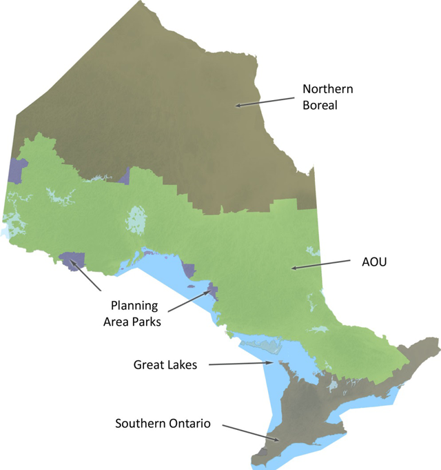
Enlarge map of management zones
Area by region